<?xml version="1.0" encoding="UTF-8"?>
<feed xmlns="http://www.w3.org/2005/Atom">
  <title type="text">Intermountain Histories</title>
  <updated>2026-04-17T19:32:21+00:00</updated>
  <generator uri="http://framework.zend.com" version="1.12.20">Zend_Feed_Writer</generator>
  <link rel="alternate" type="text/html" href="https://www.intermountainhistories.org/"/>
  <link rel="self" type="application/atom+xml" href="https://www.intermountainhistories.org/items/browse?output=rss2"/>
  <id>https://www.intermountainhistories.org/</id>
  <author>
    <name>Intermountain Histories</name>
    <uri>https://www.intermountainhistories.org</uri>
  </author>
  <link rel="hub" href="https://pubsubhubbub.appspot.com/"/>
  <entry>
    <title type="html"><![CDATA[La Mesa Fire, Bandelier National Monument]]></title>
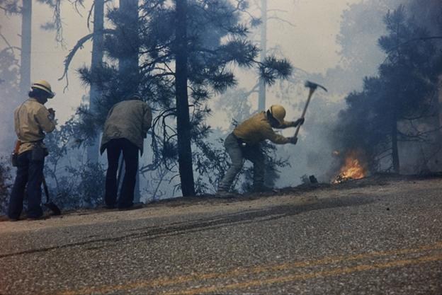
    <summary type="html"><![CDATA[<p><strong><em>In national parks and monuments, flames pose a significant threat to archaeological resources. During the 1977 La Mesa Fire, Bandelier National Monument became the first known park to conduct archaeological surveys on fire lines. </em></strong></p><img src="https://www.intermountainhistories.org/files/fullsize/c2bb9bc0b3c1876b9c14448a59827b75.jpg" alt="Firefighters battling the La Mesa Fire, c. 1977." /><br/><p>Established in 1916 to preserve Ancestral Puebloan archaeological resources near Los Alamos, New Mexico, Bandelier National Monument historically experienced few wildfires. Because the park protected cultural resources instead of natural ones, it extinguished fires to protect archaeological sites. The nearby development of the atomic bomb at Los Alamos, New Mexico, also made the Pajarito Plateau a high-risk area for federal officials, contributing to rapid suppression policies.
In 1977, the U.S National Park Service (NPS) approved NPS-18, a nationwide policy that established new protocols for fire management. Under the new “let-burn” policy, the Park Service allowed natural fires to burn and experimented with deliberate burns in controlled areas. However, the National Historic Preservation Act required archaeological surveys to approve prescribed burn areas. These policies put Bandelier in a delicate position: it had to simultaneously avoid burning cultural resources and promote the let-burn approach. As a result, park managers at Bandelier continued to suppress blazes long after most of the park system allowed them to burn.
            On June 16, 1977, the La Mesa Fire began in the Santa Fe National Forest near Bandelier’s park boundaries. Officials speculated that either a cigarette or a motorcyclist’s engine started it. Because it posed a risk to nearby communities, wildland firefighters worked to suppress La Mesa immediately. Hot, dry conditions and dense vegetation allowed it to spread quickly, threatening both residents and the national monument. By June 17, it entered Bandelier and started to advance towards Los Alamos. NPS evacuated families living in Bandelier’s Frijoles Canyon, demonstrating the immediate threat the flames posed to locals.
Below the surface of the ground, Bandelier contained numerous archaeological sites that researchers never examined. NPS used heavy equipment, including bulldozers, to construct physical barriers where flames could not access fuel. The blaze itself also threatened to destroy delicate structures. These factors meant both La Mesa and the efforts to stop it endangered the national monument. In response, Park Service scientist Millford R. Fletcher worked with cultural resource manager Cal Cummings to enlist volunteer archaeologists on fire lines who surveyed land in front of heavy equipment and recommended locations that would minimize damage to archeological sites. While they could not survey every line in the area, La Mesa damaged only forty percent of the cultural resources it threatened, demonstrating their effectiveness.
On June 21, summer rain slowed La Mesa down, allowing firefighters to contain it. It burned over 23,000 acres, becoming the largest wildfire on the Pajarito Plateau in the twentieth century. The blaze exposed gaps in NPS fire policy, which had not historically accounted for archaeological resources. While federal officials did not address the issue, park managers at Bandelier developed a new management system that ignited small, carefully monitored burns to determine whether officials could safely implement let-burn procedures near cultural resources.</p><p><em><strong><a href="https://www.intermountainhistories.org/items/show/915">For more (including 3 images) view the original article</a></strong></em></p>]]></summary>
    <published>2025-09-23T15:39:30+00:00</published>
    <updated>2026-04-17T19:32:21+00:00</updated>
    <link rel="alternate" type="text/html" href="https://www.intermountainhistories.org/items/show/915"/>
    <id>https://www.intermountainhistories.org/items/show/915</id>
    <author>
      <name>Kaylen Wilson, Northern Arizona University </name>
    </author>
  </entry>
  <entry>
    <title type="html"><![CDATA[Monterey Motel, Albuquerque, NM]]></title>
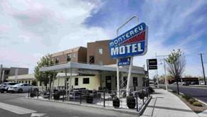
    <summary type="html"><![CDATA[<p><strong><em>In continuous use since its construction in 1937, Albuquerque’s Monterey Motel on 2402 Central Avenue is a rare gem of googie architecture preserved in form and function.</em></strong></p><img src="https://www.intermountainhistories.org/files/fullsize/f25d46bc57c66cd0d6574c9ba1c0df99.jpg" alt="The Monterey Motel as seen from the sidewalk on Central Avenue" /><br/><p>The Monterey Motel is a stellar example of googie architecture along Albuquerque’s stretch of Route 66. Googie architecture became poplar in the western United States in the mid-twentieth century and the style is characterized by a futuristic and slightly industrial appearance. The building oozes a functional and futuristic aesthetic. The original steeply pitched roof of the motel was a hallmark of the type of commercial road-side buildings that make up the bulk of examples in googie architecture. A decorative aluminum band wraps around the entire structure and contributes to the futuristic styling that demarcates it as googie. The Monterey is especially interesting since its construction predicates the googie design as a cognizant genre. The most iconic attribute of the Monterey is its original neon sign, drawing travelers in for generations with its saturated colors and mod font, easily read from the road. The design motif of sharp acute angles is carried over to the sign, with the large sans serif letters being illuminated with the glow of the hand blown neon tubes.
     The motel was the brainchild of an Albuquerque businessman named Norman Bugg. In 1937, Bugg was one of the first to realize the economic promise that Route 66 held for those who would invest in it. The site he picked for the Monterey is directly across Route 66 from Albuquerque’s Old Town district, a hot spot for tourists as they traveled down the Mother Road. The structure has managed to retain its original status of a mid-century modern traveler’s paradise and was restored in 2018 as part of larger efforts to reinvigorate Albuquerque’s historic stretch of the Mother Road.
     The Monterey Motel and its many sibling motor courts across the Duke City were thrown into flux with the construction of I40 in the late nineteen fifties. The coming of the highway created a marked difference in how vehicle tourism would function in Albuquerque. Motels gave way to budget hotels as the accommodation of choice for most travelers across the U.S. and the construction of googie motor courts like the Monterey gradually dropped off. Interestingly, the Albuquerque’s numerous motels fared decently well throughout the years despite the dip in tourism along the Mother Road. Many of the courts still operate today in some capacity, either as accommodations or as new boutiques and eateries, with the stylistic charm that once drew tourists in being re-packaged as retro flair along historic Route 66.
     Similarly, in July of 2024 the Monterey participated in an event held for fans of the <em>Borderlands</em> games. The staff of the Monterey covered the updated facilities with decrepit neon signs and rusted metal siding to provide photo-ops and entertainment for fans at the event. This sort of community engagement highlights the public’s interest in the liminal spaces and aesthetics that googie structures like the Monterey represent. The hotel has come into a new era via a greater public interest and nostalgia for what Route 66 and its historic architecture, commercial or not, represent to the American public.</p><p><em><strong><a href="https://www.intermountainhistories.org/items/show/902">For more (including 4 images) view the original article</a></strong></em></p>]]></summary>
    <published>2025-09-23T15:36:01+00:00</published>
    <updated>2026-04-17T19:32:20+00:00</updated>
    <link rel="alternate" type="text/html" href="https://www.intermountainhistories.org/items/show/902"/>
    <id>https://www.intermountainhistories.org/items/show/902</id>
    <author>
      <name>Emily MacDonell, Northern Arizona University</name>
    </author>
  </entry>
  <entry>
    <title type="html"><![CDATA[The Battle of Glorieta Pass and the Confederate Campaign in New Mexico]]></title>
    <summary type="html"><![CDATA[<p><strong><em><span style="font-weight:400;">The Battle of Glorieta Pass marked a pivotal moment in the American Civil War's Western Theater. Often called the "Gettysburg of the West," this 1862 clash determined the fate of Confederate ambitions as they attempted to expand into New Mexico and beyond.</span></em></strong></p><img src="https://www.intermountainhistories.org/files/fullsize/a7fa00d8af44b7b6e3f361212c0c14d3.jpg" alt="Battle of Glorieta Pass at Pigeon&#039;s Ranch by Roy Andersen" /><br/><p><span style="font-weight:400;">In March 1862, the Battle of Glorieta Pass emerged as a pivotal moment in the Civil War as Confederate troops attempted to seize control of New Mexico, a territory long coveted by the South for its mineral wealth and strategic position along important routes of trade. After capturing Santa Fe on March 13, Brigadier General Henry Hopkins Sibley and his Confederate forces sought to consolidate their gains by advancing toward Fort Union, the last major Union stronghold in the New Mexico territory. However, their path was obstructed by the determined forces of Colonel John Slough, who were preparing to mount a counteroffensive against Sibley’s attack.</span>
<span style="font-weight:400;">Slough's division, bolstered by 800 Colorado volunteers, began their march from Fort Union to engage Sibley’s troops. The Union strategy hinged on thwarting the Confederate advance and securing vital supply lines. As the two armies maneuvered toward each other, they both sought to control the strategic high ground at Glorieta Pass.</span>
<span style="font-weight:400;">On March 28, the two sides met in Apache Canyon, with skirmishes erupting as the Confederate forces attempted to strike the enemy first. Initially caught off guard, the Confederates regrouped and engaged the Union troops ferociously. The fighting soon escalated, with the Union holding the high ground and utilizing artillery to devastating effect against Confederate assaults. Despite this advantage, Colonel Sam Shropshire was killed, a critical blow to the Union’s command. As the battle raged, the Confederate forces made a series of bold charges in an attempt to break through Union lines. They managed to push the Federals back, but their success was tempered by heavy casualties. By the afternoon, Sibley’s forces found themselves at a critical juncture. Their position had begun to erode under the relentless fire of Union artillery, which had effectively neutralized many of their advances.</span>
<span style="font-weight:400;">In a dramatic turn of events, the Confederate forces received alarming news from their base of operations at Johnson’s Ranch. A Union column, led by Captain John Chivington, had launched a surprise attack on the Confederate supply camp, destroying vital resources and inflicting further damage. With eighty supply wagons burned and many pack animals lost the Confederates faced a tenuous situation, exacerbated by their own diminishing supplies. Recognizing the untenable nature of their position at Glorieta Pass, Sibley ordered a retreat to Santa Fe to regroup. Meanwhile, Colonel Slough seized the opportunity to coordinate a follow-up attack, intent on pushing the Confederates further back. The Union forces, now reinvigorated, were ready to capitalize on their opponent’s misfortunes. By March 29th, it was clear to the Confederate commanders that the battle had not yielded the decisive victory they had sought. Retreating to Santa Fe, Sibley hoped to reestablish communication with the Texas government for reinforcements. However, dwindling supplies hampered their efforts, leading to a chaotic withdrawal from the region as they attempted to escape the approaching Union forces. </span>
<span style="font-weight:400;">The Battle of Glorieta Pass marked a turning point in the New Mexico Campaign, symbolizing the failure of Confederate ambitions in the Southwest. Although both sides incurred significant losses—432 Union casualties and 187 Confederate—the aftermath proved disastrous for Sibley’s forces, setting the stage for further Union advances in the territory. The battle ultimately underscored the Confederacy's vulnerability, dashing their hopes of establishing a stronghold in the West, and left them to retreat back to Texas with little more than the remnants of their once-promising campaign.</span></p><p><em><strong><a href="https://www.intermountainhistories.org/items/show/878">For more (including 3 images) view the original article</a></strong></em></p>]]></summary>
    <published>2025-01-27T01:49:52+00:00</published>
    <updated>2026-04-17T19:32:20+00:00</updated>
    <link rel="alternate" type="text/html" href="https://www.intermountainhistories.org/items/show/878"/>
    <id>https://www.intermountainhistories.org/items/show/878</id>
    <author>
      <name>Benjamin Nichols, Brigham Young University</name>
    </author>
  </entry>
  <entry>
    <title type="html"><![CDATA[Dowa Yalanne Mountain]]></title>
    <summary type="html"><![CDATA[<p><strong><em>Many notable events for the Zuni people transpired on Dowa Yalanne, including traditional legends and ceremonies. It provided the Zunis protection against the invading Spanish and other raiding groups and continues to inspire and remind the Zuni people of their culture and history.</em></strong></p><img src="https://www.intermountainhistories.org/files/fullsize/ae143c3a012b84adff08586fd045f838.jpg" alt="“Dowa Yalanne Mountain.”" /><br/><p>Located in New Mexico on the Zuni reservation, Dowa Yalanne, or Corn Mountain, overlooks Zuni Pueblo at an elevation ranging in the 7000s. A Zuni legend explains that during an intense flood, the people fled to the top of the Dowa Yalanne, bringing their corn. To cause the water to recede, they sent a son and daughter of a Zuni priest into the water as an offering. Eventually the waters receded, revealing that the son and daughter turned to stone. Corn Mountain’s mesa features approximately 320 acres of Zuni sandstone, mudstone, and Dakota sandstone. Based on these sedimentary rocks, Dowa Yalanne appears to have formed during the Triassic and Jurassic periods and is recognizable by its red and white coloring. Piñon-juniper trees populate the mountain, along with smaller brush and foliage. </p><p>During the early days of European contact, Dowa Yalanne offered the Zuni people refuge from the Spanish conquistadors. In 1540, after Francisco Vasquez Coronado and his men battled at the Zuni village of Hawikuh, the remaining Zunis fled to Corn Mountain to escape Spanish occupation. Familiar with the mountain trails, they remained secluded until the Spanish left. The Zuni then returned to their villages once it appeared safe. </p><p>Zunis utilized Dowa Yalanne as a place of retreat before contact with the Spanish when conflict arose with other tribes. Zunis returned to Dowa Yalanne in 1632 after they conspired and killed two Franciscan Friars and Spanish soldiers stationed at Hawikuh. It was not until 1635 that the people of the six Zuni villages entirely left the mountain’s protection. This particular cycle continued in 1680, after the immediate events of the Pueblo Revolt, and again in 1703 when the Zunis repulsed Spanish interlopers.  From that point on, the use of Dowa Yalanne as a place of protection significantly diminished due to fewer conflicts.</p><p>Zuni rock art decorates Dowa Yalanne in locations where they took refuge. The historic engraved shields and mountain lion iconography served a magical protective function for them. Zunis still maintain sacred shrines on the top of Dowa Yalanne mesa, cementing its spiritual reminder of Zuni culture and resilience during difficult circumstances.</p><p><em><strong><a href="https://www.intermountainhistories.org/items/show/849">For more (including 4 images) view the original article</a></strong></em></p>]]></summary>
    <published>2024-09-24T18:01:38+00:00</published>
    <updated>2026-04-17T19:32:19+00:00</updated>
    <link rel="alternate" type="text/html" href="https://www.intermountainhistories.org/items/show/849"/>
    <id>https://www.intermountainhistories.org/items/show/849</id>
    <author>
      <name>Joseph Namingha, Brigham Young University</name>
    </author>
  </entry>
  <entry>
    <title type="html"><![CDATA[Mining in Madrid, NM]]></title>
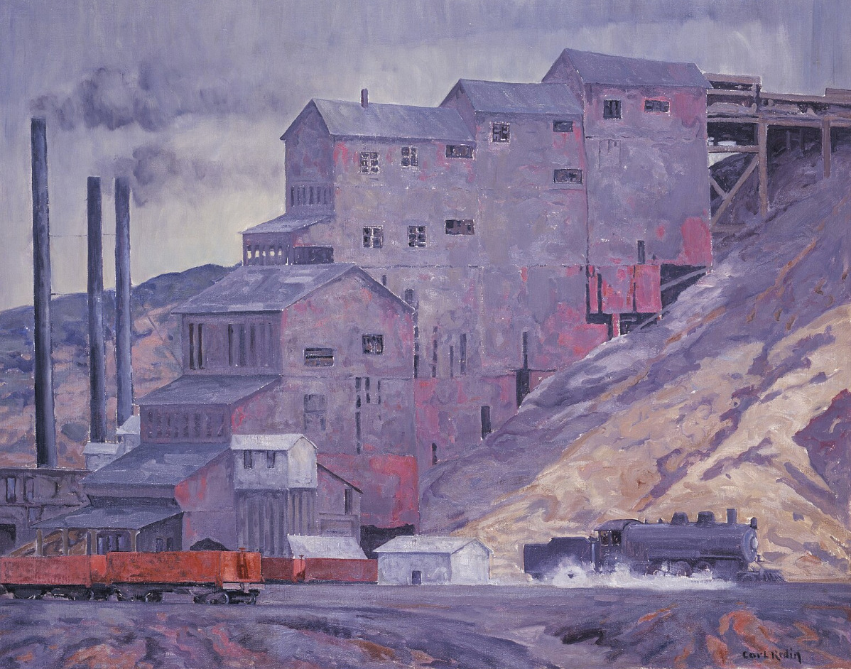
    <summary type="html"><![CDATA[<p><strong><em><span style="font-weight:400;">Once a coal mining town with mandated celebratory traditions, Madrid is kept alive today by a community of artists.</span></em></strong></p><img src="https://www.intermountainhistories.org/files/fullsize/2c557ddeacfb0b63a0565ae116711530.jpg" alt="At Madrid Coal Mine, New Mexico" /><br/><p><span style="font-weight:400;">There is a community in the mountains of Santa Fe County, New Mexico that has redeemed itself from “ghost town” status–though they still claim the title. Madrid was best known for its wealth of coal during the mining boom in the late nineteenth and early twentieth century. The town was first founded in 1869, attracting attention from its location along the Santa Fe Railroad. Traveling journalist Charles Fletcher Lummis said that there was no other railroad that “penetrated such a wonderland of the pictorial in geography and in humanity.” Trains used Madrid to refuel and stock up on coal. The prosperity of the land brought in a large enough community for businesses like the trading post, stores, schools, a diner, and a boarding house to be built and well-used in the early twentieth century. </span>
<span style="font-weight:400;">Life in mining towns is sometimes thought of as exciting–newfound wealth and communities brought together in the wake of the gilded age–but the reality was far grittier. Men, women, and children who worked in coal mines were subject to the dangers of collapsing shafts, explosions, and machinery malfunctions, as well as gas poisoning and other illnesses brought on by poor air quality. However, the corporations running the town had several initiatives that attempted to make life more enjoyable for the residents. </span>
<span style="font-weight:400;">The free electricity they provided to each home was certainly the most valuable perk, but there were also annual festivities that were required in an attempt to boost the community’s morale. As Christmas approached each year, every resident had to ornament their house with string lights, buy a Christmas tree, and make sure their house was as much of a spectacle as possible. With 3,000 residents by the 1930s, Madrid did become quite a spectacle, drawing in crowds from Albuquerque and other nearby communities in awe of the light displays. When blackouts for World War II started, the Christmas lights were put out, and shortly after the war ended, the mines were closed for good.</span>
<span style="font-weight:400;">As steam locomotives were replaced with diesel engines, coal lost its value and the mines in Madrid were shut down not long after the war ended. The population rapidly declined, and Madrid sat among other former mining towns in Santa Fe county, with the threat of complete abandonment. Yet, Madrid never quite lost its charm. It went on to be featured in several movies, from 1970 to the early 2000s, and now it is home to artists, quirky landmarks, and converted historic buildings. </span></p><p><em><strong><a href="https://www.intermountainhistories.org/items/show/805">For more (including 3 images) view the original article</a></strong></em></p>]]></summary>
    <published>2024-05-16T01:44:03+00:00</published>
    <updated>2026-04-17T19:32:18+00:00</updated>
    <link rel="alternate" type="text/html" href="https://www.intermountainhistories.org/items/show/805"/>
    <id>https://www.intermountainhistories.org/items/show/805</id>
    <author>
      <name>Megan Bailey, Brigham Young University</name>
    </author>
  </entry>
  <entry>
    <title type="html"><![CDATA[Apache County on Route 66]]></title>
    <summary type="html"><![CDATA[<p><strong><em><span style="font-weight:400;">The land on the Arizona-New Mexico border has a storied past–from Spanish trading routes and gutsy American cowboys to railroad tracks and the boom of a brand-new highway.</span></em></strong></p><img src="https://www.intermountainhistories.org/files/fullsize/c94d71a364203dd0571092e6433d1afa.jpg" alt="In Apache Land, Arizona" /><br/><p><span style="font-weight:400;">Apache County, which makes up the northeast region of Arizona, has been occupied since at least 800 A.D. by Ancestral Puebloans (formerly known as “Anasazi”). The first of many Spanish expeditions to the Arizona/New Mexico region lasted from 1540-1542, and began a tumultuous relationship with the indigenous population. In the following years Spanish colonists introduced new cattle to the region, and sheepherding became a popular practice for the next several hundred years. In 1864 the U.S. government issued a forced displacement of the Navajo people known as the “Long Walk.” It was a harsh and unforgiving journey that resulted in at least 500 deaths. One region exiled during the Long Walk later became known as Lupton, one of several unincorporated communities along Route 66. </span>
<span style="font-weight:400;">Famous for its scenic “painted cliffs,” brightly colored roadside shops, and appearance in the 1940 film adaptation of </span><i><span style="font-weight:400;">Grapes of Wrath</span></i><span style="font-weight:400;">, Lupton was built from a railroad settlement in 1905. The community's namesake, G.W. Lupton, was a trainmaster and owner of the first trading post in the area. In the post-war tourism boom of the early 1950s, the Yellowhorse family of the Navajo Reservation opened their own trading post. The building was painted a striking yellow with red and black painted signage advertising “The Indian Market Place: Deal with the Friendly Navajo.” Although Route 66 had given the area a new life after the railroad revolution, the construction plans for Interstate 40 bypassed Lupton. Like so many other little towns that survived only from the tourist revenue, Lupton soon slipped into obscurity. The shop fronts have not been well-preserved, and there is not much charm left to draw people in, but the sight of the painted cliffs when the sun hits them just right remains as breathtaking as it always was.</span>
<span style="font-weight:400;">Twelve miles west of Lupton and the New Mexico border another now deserted town called Houck has its own storied past. In 1877 James Houck, a horseback-riding mail carrier, established a trading post along his route which ran from Prescott, Arizona to Fort Wingate, New Mexico. The post, which was called “Houck’s Tank,” expanded into a small community which adopted Houck’s name. He lived a fairly successful life, but had a hard time staying out of trouble. He was no stranger to shoot-outs or plots of revenge–and his friendship with the Tewksbury family put him in the middle of a major feud between two ranching families. Known as the Pleasant Valley War or the Graham-Tewksbury Feud, it resulted in somewhere between thirty-five to fifty deaths. His career beyond mail delivery included sheepherding, mining, trading, and a position as the Apache County Deputy Sheriff. Yet he is memorialized now as the namesake for the once lively ghost town of Houck, Arizona.</span>
<span style="font-weight:400;">In late 1926, Route 66 made its way through Houck, attracting new visitors to what had once been nothing more than a trading post. Although becoming a part of Route 66 helped bring a more steady flow of business and traffic, Houck never quite blossomed the way other towns along the highway did. A gas station, a grocery store, a “Pancake House,” and a few other small establishments popped up, but much of it has since gone out of business and become overgrown. In 1998, long after the excitement died down, the Native American Bahá'í Institute opened as a place of worship, training, and gathering place for the Navajo reservation and surrounding communities. </span></p><p><em><strong><a href="https://www.intermountainhistories.org/items/show/800">For more (including 5 images) view the original article</a></strong></em></p>]]></summary>
    <published>2024-05-15T20:15:34+00:00</published>
    <updated>2026-04-17T19:32:17+00:00</updated>
    <link rel="alternate" type="text/html" href="https://www.intermountainhistories.org/items/show/800"/>
    <id>https://www.intermountainhistories.org/items/show/800</id>
    <author>
      <name>Megan Bailey, Brigham Young University</name>
    </author>
  </entry>
  <entry>
    <title type="html"><![CDATA[Golden: A Ghost Town]]></title>
    <summary type="html"><![CDATA[<p><strong><em><span style="font-weight:400;">In an overgrown cemetery, amidst tombstones and memorabilia, a child’s white metal bed frame sits above a grave. Golden, New Mexico–population zero–is a ghost town in more ways than one. </span></em></strong></p><img src="https://www.intermountainhistories.org/files/fullsize/e67fd8700f683d9e53b557c2c957ca2f.jpg" alt="San Francisco de Asis Catholic Church" /><br/><p><span style="font-weight:400;">Today the tiny Santa Fe community of Golden is known for the gold rush that it was named for, but before the gold Navajo peoples found prosperity in turquoise. The road running from Albuquerque to Santa Fe, which is now part of New Mexico 14, is still aptly referred to as the “Turquoise Trail.” In the 14th century Spanish Conquistadors made their way to the region of Mexico that would later become New Mexico and Arizona. For several hundred years they traded goods, mined, and colonized the land. </span>
<span style="font-weight:400;">It is said that the gold rush didn’t really begin in New Mexico until it was declared an American state, but nearly one-hundred years earlier in 1825 the community of Golden had its day in the sun. When Mexico gained independence from Spain in 1821, the Santa Fe trail became open to Americans for trading purposes–creating an influx of American settlers to the area, who had been few and far between during the Spanish years. Trading opportunities, cattle herding, gold, and the exciting prospect of “new” land drew Americans in from surrounding U.S. territories and states. Gold was discovered in the land just north of the San Pedro mountains and a mining district blossomed. Within the next few decades a general store, a post office, a public school, and quite a few saloons, were built as well as a Catholic church–which is now the most photographed church along the Turquoise Trail. </span>
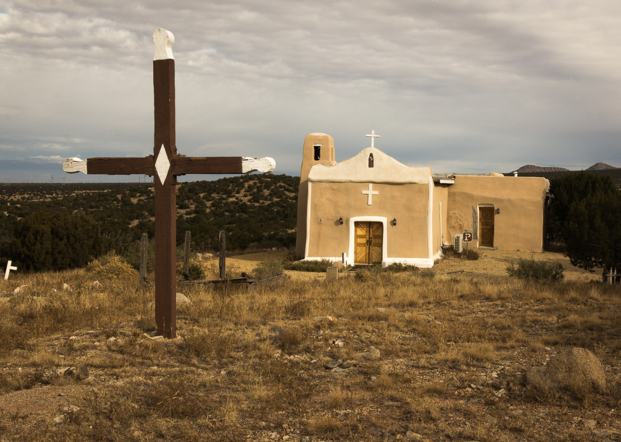
<span style="font-weight:400;">San Francisco de Asis Catholic Church, named after Saint Francis of Assisi, was built around 1830. The adobe brick plaster makeup of the church has held up well over the years, and the white painted crosses still look as bright as ever. The churchyard is home to the bodies of those who died in the fleeting time of Golden’s own “life.” Although the church provides a glimpse into the past, it isn’t completely dormant. Beloved by those who explore the grounds on their way through town, and welcoming to Sunday tourists who attend church services.</span>
<span style="font-weight:400;">The era of growth and excitement in the community was short-lived and ended almost as suddenly as it had begun. When the 1825 gold rush era ended, there was little reason to stay. The few who remained resorted primarily to agriculture to make their living. There was a dwindling and largely fruitless attempt by some remaining residents to dig up the last of the gold, but there was only so much to be found before even the most stubborn of them abandoned the pursuit. A hundred years after the initial gold rush there were so few people remaining that Golden lost its township status. In 2021 the census reported a population of zero residents of Golden, but the Turquoise Trail continues as a scenic route for road trips and the church with its overgrown cemetery stands as a monument–a living memory of all that once was. </span></p><p><em><strong><a href="https://www.intermountainhistories.org/items/show/799">For more (including 5 images) view the original article</a></strong></em></p>]]></summary>
    <published>2024-05-15T19:52:11+00:00</published>
    <updated>2026-04-17T19:32:17+00:00</updated>
    <link rel="alternate" type="text/html" href="https://www.intermountainhistories.org/items/show/799"/>
    <id>https://www.intermountainhistories.org/items/show/799</id>
    <author>
      <name>Megan Bailey, Brigham Young University</name>
    </author>
  </entry>
  <entry>
    <title type="html"><![CDATA[Route 66]]></title>
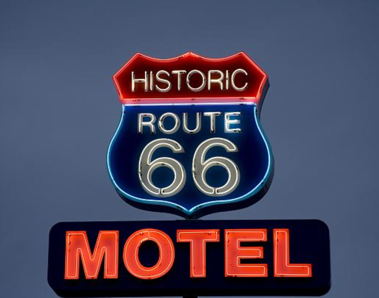
    <summary type="html"><![CDATA[<p><strong><em><span style="font-weight:400;">Route 66 is famous for its 1950s era diners and eclectic curio shops, but it was a road traveled long before it was paved and has remained iconic even after it was removed from the highway system.</span></em></strong></p><img src="https://www.intermountainhistories.org/files/fullsize/e07e210fcc5e7f610fdad382fdbd04f5.jpg" alt="Neon sign for the Historic Route 66 Motel in Seligman, Arizona." /><br/><p><span style="font-weight:400;">Route 66 revolutionized cross country travel in America. With mass auto production and transportation accessibility on the rise, the highway’s construction in 1926 was truly a product of its time. Beginning in Chicago, Illinois and ending in Santa Monica, California the new highway gave Americans a convenient way to travel west, a practice that had become increasingly popular the previous century. </span>
<span style="font-weight:400;">Route 66 was planned around several trade routes and old roads. Geographically similar paths had been used by Kiowas, Cheyennes, Comanches, and other Native peoples for centuries. In later years these paths continued to be well traversed by Euro-Americans. Many of the automobiles on the highway were occupied by migrants, but there were plenty of vacationers as well. An exciting new concept, the “road trip,” was born in the 1920s providing Americans with the opportunity to create a grand adventure of their own.</span>
<span style="font-weight:400;">As one of the original U.S. highways Route 66 was often called  “America’s Main Street” in its early days, and later, “The Mother Road,” as coined by John Steinbeck. Whole communities and businesses were established along the highway which thrived off of tourism. In the 1930s about 200,000 migrants drove cars, took trains, and even walked along Route 66, hoping for a better chance of survival and solace further west. The end goal was often California, but most of them ended up settling somewhere else along the way. America’s involvement in World War II a decade later called for the rationing of gas. This changed the demographic of highway traffic, but did not diminish it. Transportation of war supplies, military troops, and new job opportunities brought another wave of westward travelers in the mid 1940s. As the war ended, patriotism and an increased emphasis on the nuclear family led to another boom in tourism. A long drive along Route 66, a stop for dinner and photo ops, and a night or two in a roadside motel made for a relatively affordable family vacation. </span>
<span style="font-weight:400;">Beginning in 1957, Route 66 was gradually replaced by Interstate 40, whose gradual construction was mostly completed by the 1970s. Traversing similar east-west latitudes, it became the preferred route designated highway for cross country travel. Much like familiar boom-bust cycles associated with gold and other mining rushes in the West, the sudden shift of traffic away from Route 66 resulted in  an abundance of ghost towns. Now, it is the nostalgia of Route 66 and its seemingly permanent existence in the past that attracts tourists. Not everyone picked up and left town when the “rush” was over. Many of the businesses that either stayed open or have since been reopened have made a living off of nostalgia, curiosity, and the prospect of adventure. </span></p><p><em><strong><a href="https://www.intermountainhistories.org/items/show/798">For more (including 4 images) view the original article</a></strong></em></p>]]></summary>
    <published>2024-05-15T19:33:31+00:00</published>
    <updated>2026-04-17T19:32:17+00:00</updated>
    <link rel="alternate" type="text/html" href="https://www.intermountainhistories.org/items/show/798"/>
    <id>https://www.intermountainhistories.org/items/show/798</id>
    <author>
      <name>Megan Bailey, Brigham Young University</name>
    </author>
  </entry>
  <entry>
    <title type="html"><![CDATA[ Women in Los Alamos during the Manhattan Project <br />
]]></title>
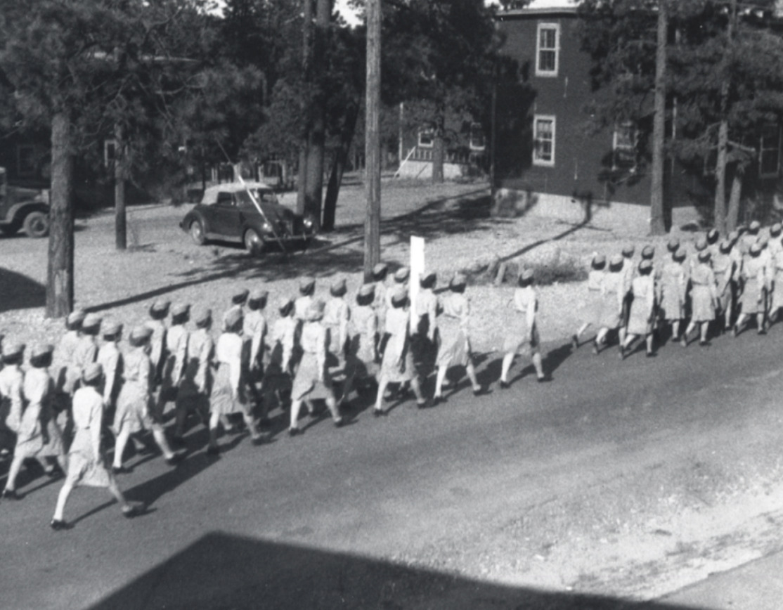
    <summary type="html"><![CDATA[<p><strong><em>With the war effort withdrawing men from the domestic labor force, women became an increasingly important part of the Manhattan Project in Los Alamos. </p></strong></p><img src="https://www.intermountainhistories.org/files/fullsize/c8f195c81db8f6804378056bc75c3f0b.jpg" alt="WAC March in Los Alamos" /><br/><p><span style="font-weight:400;">Wartime labor shortages were a constant struggle for the United States during World War II. They needed to send troops overseas, develop weaponry, spy on their enemies, strategically plan, and mobilize the entire nation as quickly as possible. By 1943, the United States Army was 200,000 men short for their invasion on D-Day, they were in need of 315 more physicists for their defense projects, and the Manhattan Project was desperately in search of all kinds of labor from scientists and engineers to machinists and pipefitters. In response, President Franklin D. Roosevelt signed into existence the Women’s Army Auxiliary Corps established “for the purpose of making available to the national defense the knowledge, skill, and special training of women of the nation” on May 15, 1942. Still facing discrimination, unequal pay, and fewer opportunities than their male counterparts, women played an essential role in World War II, especially in Los Alamos. </p>
<span style="font-weight:400;">Because Los Alamos was such a restricted town and the directors wanted to limit the number of outsiders, General Leslie Groves encouraged wives of scientists to work on the project in whatever capacity they could. As an incentive, they provided nursery schools for their young children to aid with childcare. Despite the government’s encouragement, some women were still hesitant to work on the project over concerns for their family’s well-being. Many had not expected to work at all, and quite a few were dissatisfied with the living conditions in which they now were expected to raise their children. Charlotte Serber, the only female group leader at the laboratory, wrote, “For the potential working wife, there was one chief worry. Could she manage her home here on the mesa and work too?” These were fair concerns. The conditions under which they were expected to work were difficult. They were isolated from extended family, were allowed only one day off of work per month for shopping in Santa Fe, were expected to work forty-eight hours in a week, and had almost no bargaining power to shift their rules or salary. They were also far less likely to gain security clearance than their male counterparts, so it was unlikely that they knew what they were helping create. </p>
<span style="font-weight:400;">Despite these stringent circumstances, many women in Los Alamos did work on the secretive atomic gadget. By October 1944, women constituted about 30% of the labor force in the Tech Area, hospital, and schools. It is also notable that although they did employ some women in clerical positions, the vast majority were scientists or technicians. They were metallurgists, engineers, physicists, chemists, and teachers, involved in every aspect of the atomic effort until the very end. The exception for this participation was in Project Alberta. This was the very last phase of the project; the physical delivery of the bomb to the Pacific island Tinian where the nuclear components were assembled before being dropped on Japan. Women who had spent years contributing to this moment were left behind in the United States to learn about the bombingsfrom the same newspapers as everyone else. However, the atomic bomb could not have been built as quickly or efficiently as it was without the contribution of women. They faced gender discrimination, suboptimal conditions, and unfair pay to contribute to the atomic effort in Los Alamos. </span>

</p><p><em><strong><a href="https://www.intermountainhistories.org/items/show/756">For more (including 3 images) view the original article</a></strong></em></p>]]></summary>
    <published>2023-09-24T18:36:48+00:00</published>
    <updated>2026-04-17T19:32:16+00:00</updated>
    <link rel="alternate" type="text/html" href="https://www.intermountainhistories.org/items/show/756"/>
    <id>https://www.intermountainhistories.org/items/show/756</id>
    <author>
      <name>Abigail Beus, Brigham Young University</name>
    </author>
  </entry>
  <entry>
    <title type="html"><![CDATA[The Trinity Site and the First Atomic Bomb<br />
]]></title>
    <summary type="html"><![CDATA[<p><strong><em>The first successful detonation of an atomic weapon on July 16, 1945 in a remote New Mexican desert had global and historic consequences. “A new thing had been born; a new control; a new understanding of man, which man had acquired over nature” (Isidore I. Rabi). </p></strong></p><img src="https://www.intermountainhistories.org/files/fullsize/bde97f62bde69872a28b0c4c3d01417d.jpg" alt="The Gadget Aerial View" /><br/><p><span style="font-weight:400;">Even after the United States and its World War II allies accepted Germany’s surrender on May 8, 1945, the conflict still raged in the Pacific with Japan. Japanese resistance was fierce as the United States painstakingly advanced toward Tokyo. As the allied forces moved island by island, fighting in sweltering jungle, both sides suffered heavy losses. It was at this crucial moment that the scientists of the secret American Manhattan Project began planning for a test that would not only change the course of the war, but also the future of international relations. </p>
<span style="font-weight:400;">The United States, in collaboration with allied Great Britain, had been developing an experimental master weapon since August 1942. Code-named “The Manhattan Project,” this highly secret endeavor largely took place in Los Alamos, New Mexico although there were participating teams at Oak Ridge, Tennessee and Hanford, Washington. In this inaccessible New Mexican desert, hundreds of physicists, chemists, engineers, and military personnel gathered in secret to theorize and create the deadliest weapon known to man. </p>
<span style="font-weight:400;">By the end of 1944, there were two designs and two bombs, Little Boy and Fat Man. Little Boy used a gun-type fission design which shot uranium 235 at itself to reach supercritical mass, resulting in the single largest explosion of its time. The Los Alamos scientists were confident that this design would work and did not want to waste any precious material on a test. Little Boy had used all available U235, so any test would deplete the United States’ supply and would require too much time for the project to regenerate at its Oak Ridge site. Little Boy would go on to be dropped on Hiroshima on August 6th, 1945 and become the first nuclear bomb used in warfare.  </p>
<span style="font-weight:400;">On the other hand, Fat Man utilized an implosion design with explosives surrounding the highly reactive plutonium core. The idea was that the inward-facing explosives would trigger an explosive reaction of the plutonium and result in a larger blast than its Little Boy uranium counterpart. The scientists were less confident in this design. Plutonium had only been discovered at the end of 1940, and the implosion method was difficult to master. If each explosive was not uniform in strength and distance, the correct reaction would not begin, and the overall impact would decrease. Due to these doubts and the easier access to plutonium, the Los Alamos scientists decided to test “The Gadget.” </p>
<span style="font-weight:400;">The first step was finding somewhere to detonate a 10,000 ton bomb without alerting the international community. They decided on a stretch of high desert between New Mexico and Texas called Jornada del Muerto, translated as “Journey of Death.” It was later named the Trinity Site, likely inspired by Robert J. Oppenheimer’s interest in the Hindu concept of the three gods of preservation, destruction, and creation. On May 31, 1945, the requisite shipment of plutonium arrived in Los Alamos from the Hanford facility and scientists began to assemble Fat Man. Up to this point, Los Alamos had not housed a significant supply of plutonium, so all work on Fat Man was done speculatively or at miniscule scales. Working at a harried pace, scientists and engineers readied and transported a plutonium core to Trinity by July 13. Harry Truman, newly inaugurated President of the United States, wanted the test completed before the Potsdam conference with Churchill and Stalin on July 17, but weather conditions made it difficult for the scientists to comply. Finally, at 5:30 am on July 16, “The Gadget” detonated. </p>
<span style="font-weight:400;">Many reactions have been recorded describing the physical experience as well as moral and philosophical implications of the detonation. The light was so powerful that Georgia Green, a blind student miles away at the University of New Mexico asked “What’s that?” Physicist Isidore I. Rabi, who observed from ten miles away at base camp wrote, “Suddenly, there was an enormous flash of light, the brightest light I have ever seen or that I think anyone has ever seen. It blasted; it pounced; it bored its way right through you. It was a vision which was seen with more than the eye. It was seen to last forever.” Rabi also acknowledged the historic and philosophical weight of the moment, “A new thing had been born; a new control; a new understanding of man, which man had acquired over nature.” Alongside confusion and fear expressed by some locals and trepidation expressed by some Los Alamos scientists, there was also great enthusiasm and excitement. Project officials immediately sent a coded telegram announcing the “satisfactory operation” to Truman, just before his meeting with Churchill and Stalin.</p>
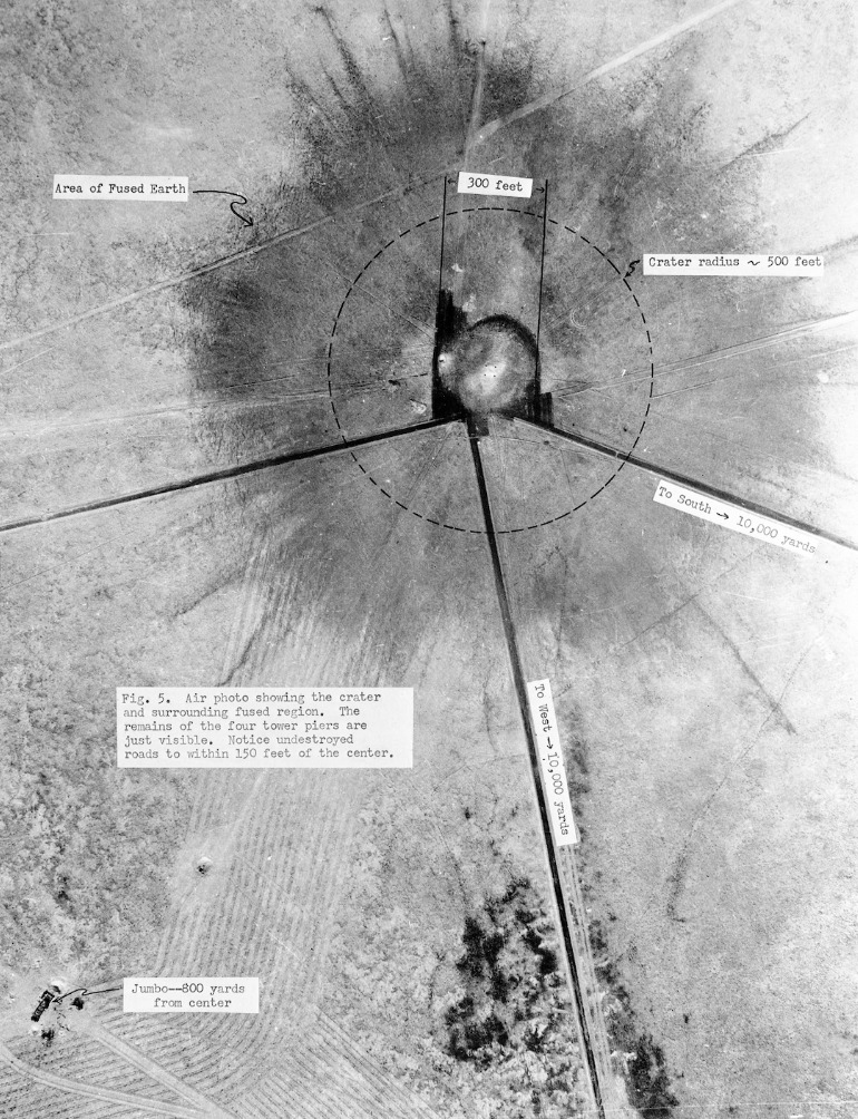
<span style="font-weight:400;">Back at the Trinity site, the scientists emerged from their safe havens and inspected the damage. The Gadget had destroyed every living thing within 1,200 feet of ground zero and disintegrated the steel tower on top of which it had been placed. It was, in the words of General Groves, “successful beyond the most optimistic expectations of anyone” and even larger than Little Boy. Because of its success at the Trinity Site, the Fat Man model would later be dropped on Nagasaki on August 9th, three days after Little Boy obliterated Hiroshima. </p>
<span style="font-weight:400;">Today, Trinity remains a highly radioactive site. Visitors are only allowed to visit two days a year. There are replicas of the bomb casing and the tower. Part of the original crater remains and reveals pockets of Trinitite, a green residue of highly radioactive sand particles melted by incredible temperatures into a glass-like substance. It can only be found at the Trinity Site and is illegal to collect for health concerns. Here, the first man-made atomic weapon detonated which aided in ending WWII and ushering in the age of atomic weaponry and mutually assured destruction. This continues to define international relations today. </span>


</p><p><em><strong><a href="https://www.intermountainhistories.org/items/show/755">For more (including 10 images) view the original article</a></strong></em></p>]]></summary>
    <published>2023-09-20T20:26:47+00:00</published>
    <updated>2026-04-17T19:32:16+00:00</updated>
    <link rel="alternate" type="text/html" href="https://www.intermountainhistories.org/items/show/755"/>
    <id>https://www.intermountainhistories.org/items/show/755</id>
    <author>
      <name>Abigail Beus, Brigham Young University</name>
    </author>
  </entry>
  <entry>
    <title type="html"><![CDATA[Life in Los Alamos: Linking the Past and Present <br />
]]></title>
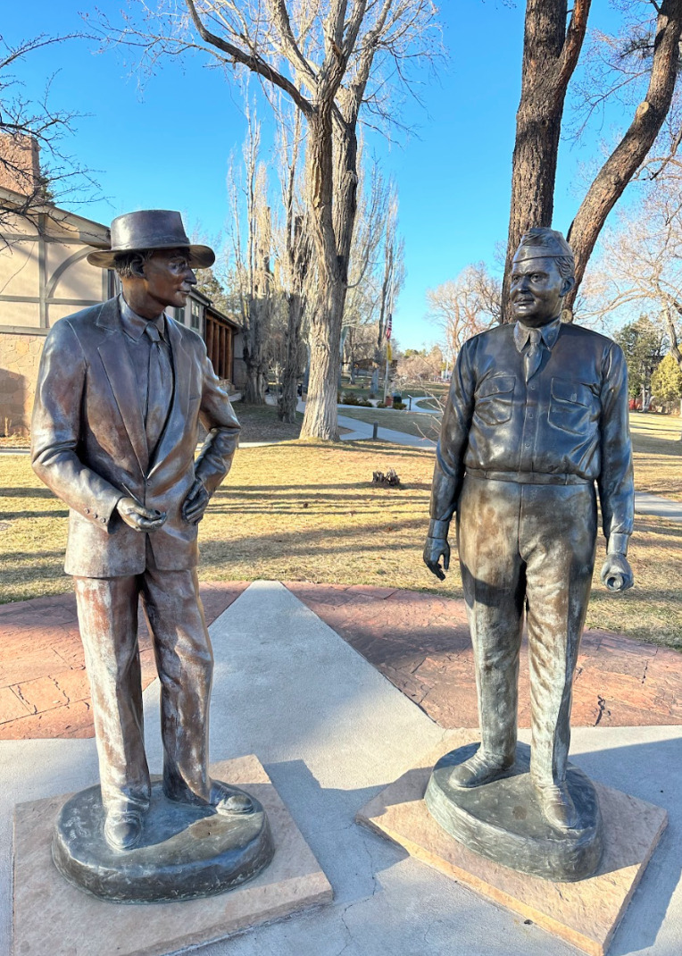
    <summary type="html"><![CDATA[<p><strong><em>Los Alamos residents in the 1940s found themselves in unusual circumstances. John von Neumann explained that, “At great expense we have gathered on this mesa the largest collection of crackpots ever seen.” Yet these people continued life under the cover of secrecy and created a community which has lasted until this day. 	</p></strong></p><img src="https://www.intermountainhistories.org/files/fullsize/a56ce2e0f40dcd7d1a6e2fe9af1ddcf0.jpg" alt="Statue of Oppenheimer and Groves" /><br/><p><span style="font-weight:400;">As the scientists and military personnel worked furiously to create an atomic weapon during the latter years of WWII, many moved to the classified town of Los Alamos, New Mexico. Because their project was shrouded in such secrecy, they were required to move themselves and their family without knowing many of the details of their new job or location. Although the civilian and academic director, J. Robert Oppenheimer, tried to make it as much of a collaborative and normal operation as possible, the nature of their assignment meant that living in Los Alamos was unique. </p>
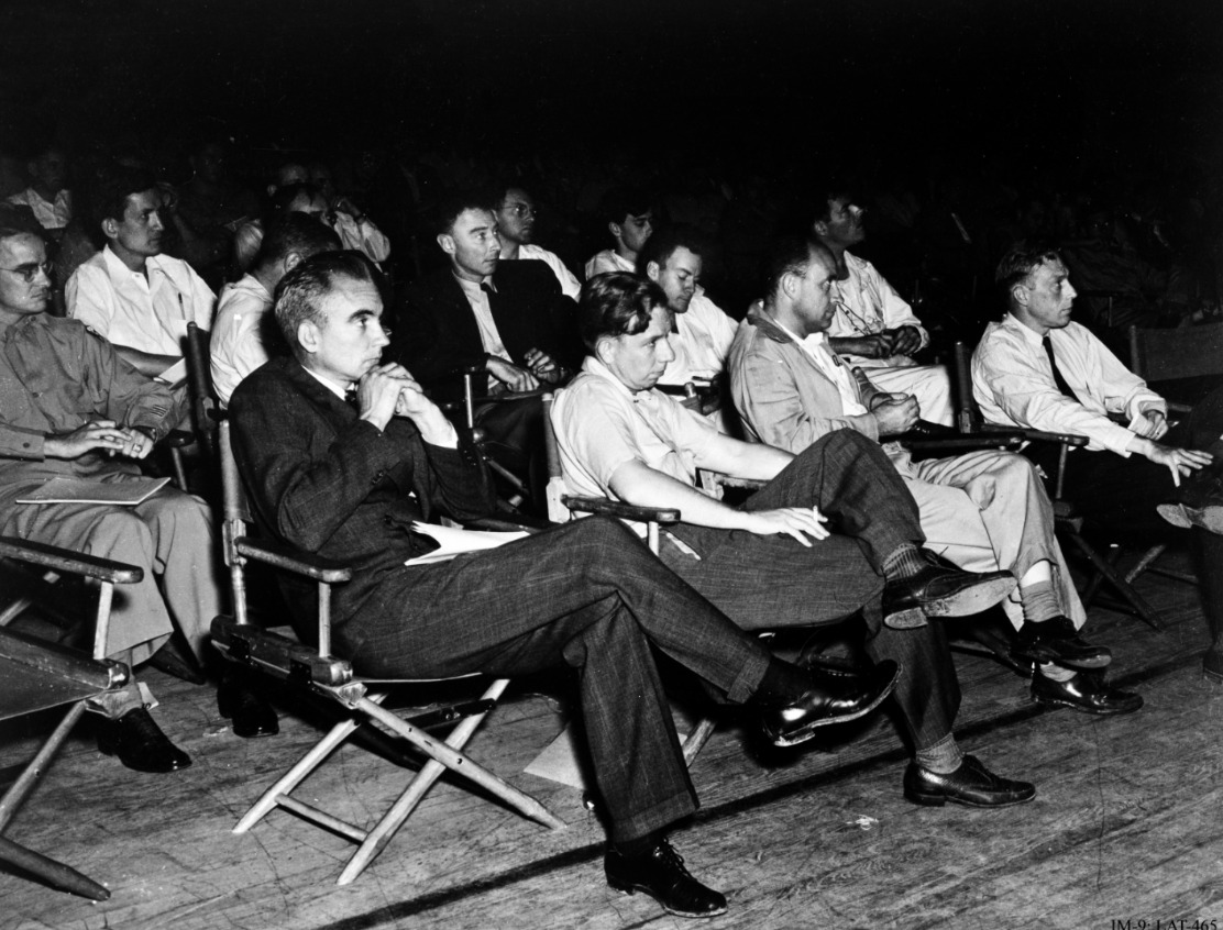
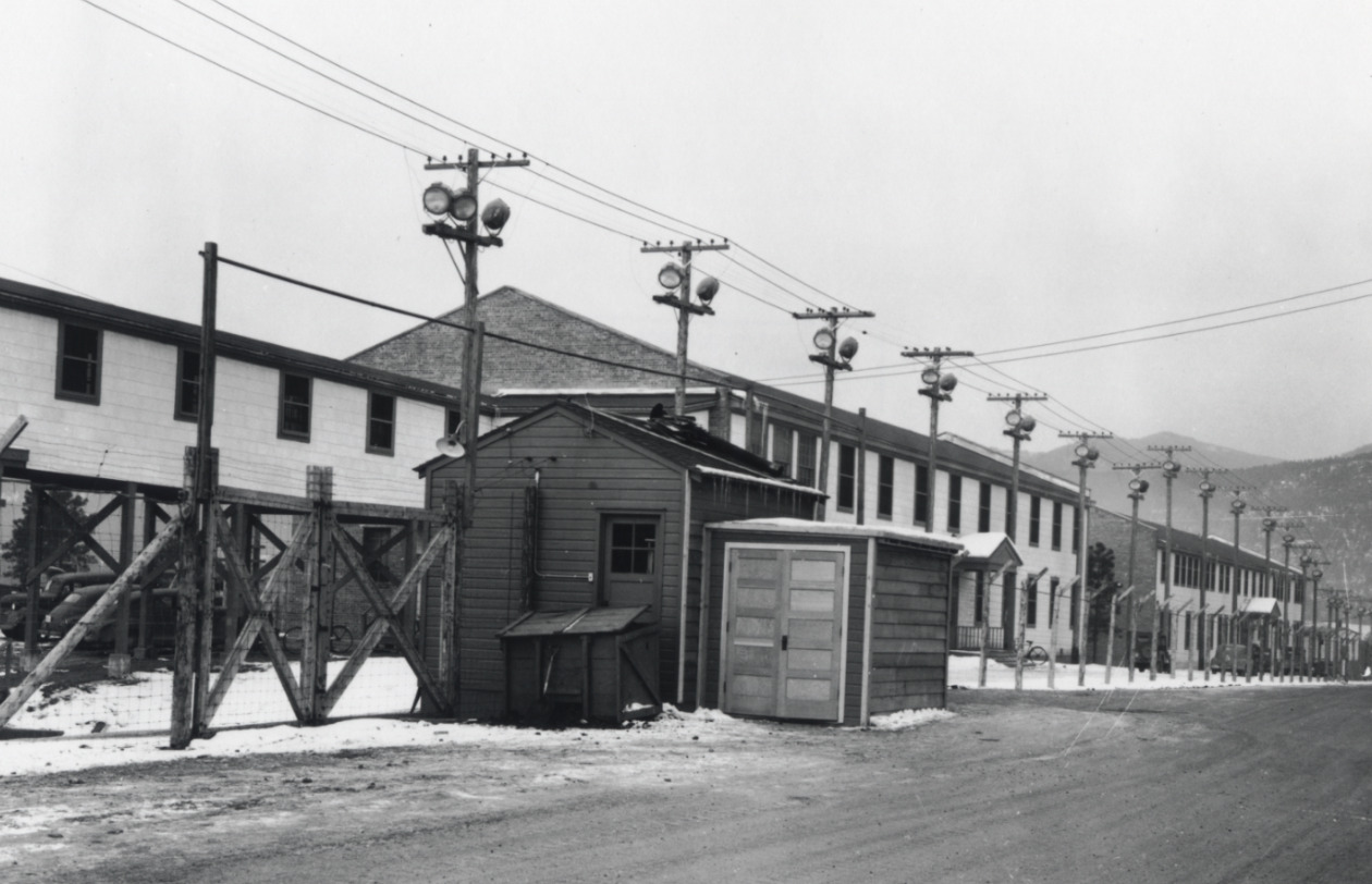
<span style="font-weight:400;">Many scientists arrived without knowing exactly where they would be working or what they would be doing. They were not even allowed to tell their spouses what their work in the restricted laboratories entailed. Secrecy was of the utmost importance. Oppenheimer spread disinformation to nearby cities, such as Santa Fe, that they were working on an electric rocket. Mail for all scientists was addressed to Box 1663, Sandoval County, Rural. It was liable to searches and some outgoing mail was redacted for security concerns. Even phone calls were monitored—army intelligence agents were obvious in listening in on people’s private conversations. Barbed wire covered the scenic landscape and made some workers feel as though they were the ones imprisoned rather than the liberators of those in European prison camps. </p>
<span style="font-weight:400;">Despite the secrecy and sometimes oppressive security, many familiar aspects of daily life continued in Los Alamos. Many women were given clerical jobs such as secretaries or computer operators to keep them occupied while their husbands worked. Children continued to attend school and babies continued to be born. In regards to the baby boom, the military official General Leslie Groves grumbled that they were simply taking advantage of the free healthcare awarded to those in the army effort. The few movies which were allowed to play were quite popular. In a move for additional entertainment, engineers and scientists threw amateur theatricals which even featured the eminent Oppenheimer in the role of “corpse.” </p>
<span style="font-weight:400;">The setting of Los Alamos itself served as a diversion for employees and their families. Oppenheimer had picked the site of Los Alamos for its beauty and openness. He thought that it could give the scientists a sense of freedom amidst all of their restrictions. Placed on top of towering mesas flanked by green mountains and overlooking fantastic natural features, there were many opportunities for outdoor recreation. During the winter, avid skiers trekked up the nearby Jemez Mountains and skied back down to their homes. The outdoor ice rink, built in 1936, became an unofficial youth center for local children to spend their winters with friends. The warmer months brought camping, horseback riding, fishing, and hiking. Curious children and adults also explored the many nearby Ancestral Puebloan archaeological sites and ruins. </p>
<span style="font-weight:400;">Even though Los Alamos was a unique environment of brilliant scientists sequestered in the wilderness, life found a way to continue in relative normalcy. It grew out of a wartime necessity into a long-lasting community with unusual origins. Today, Los Alamos is home to around 13,000 people and a National Laboratory specializing in weapon-making for the United States government. The community maintains their engagement in many of the recreational activities that their predecessors did. The Pajarito Ski Hill and the ice rink continue to gather youth and adults during the winter months. Warmer times of the year bring outdoor sports, especially running and hiking, among the abundant natural landscape. Summer is also the ideal time for weapons testing. For seasoned Los Alamos citizens, a large explosion miles away that rattles windows and door frames is unsurprising—rarely do they suspect an earthquake.  The work and life of Los Alamos persists nearly a century after it was settled. </span>


</p><p><em><strong><a href="https://www.intermountainhistories.org/items/show/754">For more (including 5 images) view the original article</a></strong></em></p>]]></summary>
    <published>2023-09-20T19:36:59+00:00</published>
    <updated>2026-04-17T19:32:16+00:00</updated>
    <link rel="alternate" type="text/html" href="https://www.intermountainhistories.org/items/show/754"/>
    <id>https://www.intermountainhistories.org/items/show/754</id>
    <author>
      <name>Abigail Beus, Brigham Young University</name>
    </author>
  </entry>
  <entry>
    <title type="html"><![CDATA[Jewish Contribution to the Manhattan Project ]]></title>
    <summary type="html"><![CDATA[<p><strong><em>Jewish participation in the Manhattan Project, particularly in Los Alamos, was an essential part of the operation's success. They continued to support their country despite local discrimination and the tragedy of World War II occurring abroad. </em></strong></p><img src="https://www.intermountainhistories.org/files/fullsize/89d79d7a997cf1681e9e7681568b097e.jpg" alt="Manhattan Project Scientists" /><br/><p>The United States’ development of the first atomic bomb would not have been possible without the contribution of Jewish Americans and Jewish refugees who fled Nazi Germany and war-torn Europe throughout the Manhattan Project. In August of 1939, Albert Einstein, Leo Szilard, and Enrico Fermi drafted and sent a letter to President Roosevelt via Alexander Sachs, warning the President of the potential use of atomic power in weaponry. This, in addition to another letter sent by British-Jewish scientists, led Roosevelt to form an advisory committee on uranium and, eventually, create the Manhattan Project.</p><p>Significantly, every person involved in the drafting and deliverance of this letter were Jewish or had close Jewish family members. Of the four involved, three were European refugees. Einstein was from a family of German Ashkenazi Jews and fled to the United States in 1933. Szilard was from a Hungarian Jewish family and fled to England in 1933 and then the United States in 1938. Fermi, while himself not Jewish nor German, was married to a Jewish woman which required him and his family to flee his home of Italy in 1938. Sachs was American-Jewish and an important advisor to President Roosevelt. All were impacted by the anti-Semitism of Germany and were respected and prominent enough to sway the President of the United States into forming a committee. Subsequent letters and information, much of which was provided by Jewish scientists, followed and increased the breadth of the project. </p><p>Jewish involvement in the Manhattan Project burgeoned as the war continued. J. Robert Oppenheimer, a young American Jew, was placed as the head of the Los Alamos branch of the Manhattan Project. He created four divisions in the Los Alamos lab, with the T-division, the theoretical division, being the most important. Of the 86 members in this division, 18 were Jewish—almost 21%. Even more impressive, of the eight groups in 1945, five were led by Jewish scientists such as Richard Feynman, Hans Bethe, and John von Neumann. Although Jews only constituted around .05% of the US population at the time, they made up a significant portion of the scientists at Los Alamos National Laboratory. </p><p>Jewish involvement in the Manhattan Project, as well as the project itself, were not known by the American public, and antisemitic prejudice was commonplace. In the 1920s, before J. Robert Oppenheimer attended, the president of Harvard, A. Lawrence Lowell, called for a quota of Jews to keep their presence sparse in the university. Even in Los Alamos, where Jewish scientists were important pioneers of the Manhattan Project, General Leslie Groves, the project’s military leader, stated, “I don’t like certain Jews, and I don’t like certain well-known characteristics of theirs.” Some Jewish scientists, such as Leo Szilard, were tailed by the FBI and noted for their “Jewish extraction” and “foreign tongue.”</p><p>At the same time, Los Alamos was a relative haven for these Jews. They were allowed in the upper echelons of decision-making and they were not stripped of titles or rewards because of their background. Ellen Bradbury Reid, an Anglo child in Los Alamos recalled, “I would not say [it was] a utopian situation, but. . . now I realize there were a lot of Jewish people, the European Jewish community who were there. I had no idea. . . [we] were all sort of in the same soup.” Despite prejudice, Jewish scientists were largely able to find footing in Los Alamos and thrive in the project. Jewish scientists in the Manhattan Project made a substantial and powerful impact in crafting the bombs which would end the war that, in total, killed over six million Jews. </p><p><em><strong><a href="https://www.intermountainhistories.org/items/show/753">For more (including 7 images) view the original article</a></strong></em></p>]]></summary>
    <published>2023-09-13T00:46:14+00:00</published>
    <updated>2026-04-17T19:32:16+00:00</updated>
    <link rel="alternate" type="text/html" href="https://www.intermountainhistories.org/items/show/753"/>
    <id>https://www.intermountainhistories.org/items/show/753</id>
    <author>
      <name>Abigail Beus, Brigham Young University</name>
    </author>
  </entry>
  <entry>
    <title type="html"><![CDATA[Dorothy McKibbins: The Gatekeeper of Los Alamos ]]></title>
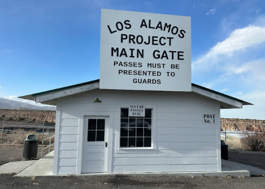
    <summary type="html"><![CDATA[<p><strong><em>The Manhattan Project would not have been possible without the efforts of Dorothy McKibbin, the Gatekeeper of Los Alamos. From attaining marriage licenses to transferring phone calls, Dorothy McKibbin was an integral and diversely skilled cog in the large machine of building the first nuclear weapons. </p></strong></p><img src="https://www.intermountainhistories.org/files/fullsize/5c401996b7cfdc416ba17d96a788fbec.jpg" alt="Los Alamos Project Main Gate Replica" /><br/><p><span style="font-weight:400;">Once General Leslie Groves and Dr. J. Robert Oppenheimer chose Los Alamos, New Mexico as the place to build the atomic bomb; hundreds of bewildered employees streamed into the nearby town of Santa Fe. Due to the confidentiality of the Manhattan Project, recruitment was difficult and details provided to the new hires were vague because of the classified nature of their work. They were told that their work would helpe war effort and be located in the scenic mesas of New Mexico, but little else. After a long train ride to the nearby town of Lamy, scientists and their families hauled their luggage through the winding streets of Santa Fe, looking for 109 East Palace Avenue—the only address they had been given. There, they were met by a simple red and blue sign reading “United States Engineer Office No. 3” and the welcoming presence of Dorothy McKibbin. </p>
<span style="font-weight:400;">In 1932, recently-widowed Dorothy McKibbin moved to Santa Fe from Kansas with her son, hoping for a new life. When she met Dr. J. Robert Oppenheimer in 1943, she found one. Oppenheimer recognized her comforting, calming, and competent presence and asked her to be a War Department secretary with unspecified duties. Like the other personnel, she only knew that her job concerned an essential war project. As she discovered after accepting the position, duties encompassed everything from disciplining Nobel laureates, receiving classified mail, enforcing security, helping lost families find the way to their new homes, and more. She was there for some of the most important moments of the project, even observing the Trinity Test from a car parked near Albuquerque. To Dorothy McKibbin, “Working at 109 was more than just a job. It was an exciting experience. Our office served as the entrance to one of the most significant undertakings of the war or, indeed, of the twentieth century.” </p>
<span style="font-weight:400;">For the entirety of the Manhattan Project she was the point of contact between the secret city and the rest of the world, earning herself the nickname of  the “Gatekeeper of Los Alamos.” After the Manhattan Project concluded, the site was renamed the Los Alamos National Laboratory, and McKibbin continued to work there until her retirement in 1963. She spent her retirement organizing community programs in Los Alamos and Santa Fe until her death in 1985. Today, a room in the Los Alamos History Museum is named in her honor, and although her office at 109 East Palace currently houses a gift shop, its original iron gate which once welcomed thousands to the secret city is on display at the Los Alamos History Museum. </span>
</p><p><em><strong><a href="https://www.intermountainhistories.org/items/show/752">For more (including 4 images) view the original article</a></strong></em></p>]]></summary>
    <published>2023-09-08T01:24:19+00:00</published>
    <updated>2026-04-17T19:32:16+00:00</updated>
    <link rel="alternate" type="text/html" href="https://www.intermountainhistories.org/items/show/752"/>
    <id>https://www.intermountainhistories.org/items/show/752</id>
    <author>
      <name>Abigail Beus, Brigham Young University</name>
    </author>
  </entry>
  <entry>
    <title type="html"><![CDATA[Bathtub Row ]]></title>
    <summary type="html"><![CDATA[<p><strong><em>As scientists raced to build the first atomic weapon during WWII, they were required to sacrifice their time, academic careers, energy, bathtubs, and more in the remote desert highlands of New Mexico. </p></strong></p><img src="https://www.intermountainhistories.org/files/fullsize/81238fa6d58203850c43f89b67708cda.jpg" alt="Los Alamos Infrastructure " /><br/><p>As World War II raged into the 1940s, each country in the war was an avid participant in the race for scientific advancement. With such high stakes, the United States invested two billion dollars—over $33 billion today—in the creation of the atomic bomb. This massive project was dubbed the Manhattan Project, after its headquarters in New York, despite largely taking place in the remote highlands of New Mexico.</p><p><span style="font-weight:400;">While the United States had fiscal resources to invest in the project, they did not have much time. Both the Germans and the Soviets were developing their own nuclear weapons, and it seemed that whoever discovered how to harness the power of the atom first would win the war. The speed and urgency of the venture inevitably meant that some details were overlooked. Construction teams were tasked with building housing for thousands of men, women, and children in the remote deserts of New Mexico in total secrecy. The workmanship of many of these early houses was shoddy at best. Project builders were not only short on time, but materials. In particular, iron was a scarce resource and largely reserved for the war effort. Understandably, it could hardly be used for iron bathtubs. Due to these factors, the majority of scientists, military personnel, and their families lived in small, relatively iron-less, hastily built homes with only a few variations of bathroom fixtures—none of which included bathtubs. </span>
<span style="font-weight:400;">Only a single row of houses had the luxury of bathtubs because they were built before the war and had originally belonged to teachers of a secondary boys’ ranch school. These “master cottages” were some of the only buildings already built when the government bought the land and were a coveted luxury. Reserved for men such as Nobel-Prize winning Englishman Sir James Chadwick, explosives expert George Kistiakowsky, bomb designer Max Roy, ordnance director William S. “Deak” Parsons, and head scientist Robert J. Oppenheimer, bathtubs were a sign of prestige in this secret New Mexico town. According to local legend, Alice Kimball Smith, wife of scientist Cyril Smith, coined the term “bathtub row.” This effectively differentiated between the comfortable ranch school homes with bathtubs and those of government construction with showers.</p>
<span style="font-weight:400;">Despite the obvious disparity, many on Bathtub Row were willing to share their good fortune. Robert Oppenheimer was reportedly a generous host who invited many in the community into his home for classified discussions, drinks, and dinner parties. Ordnance director William S. Parsons’ home was fortunate enough to have two bathtubs. He often allowed military men to use them if they were injured and unable to stand for long periods of time under a shower. These bathtubs were also used to entice babysitters who would be rewarded with a relaxing soak in their neighbor’s home in exchange for an afternoon taking care of the owners’ children.</p>
<span style="font-weight:400;">Today, these houses are privately owned, but remain part of the Los Alamos National Historical Landmark District. In 2007, the Los Alamos population petitioned to change the street name from 20th to Bathtub Row. The community has continued to embrace this humorous anecdote from WWII through naming the local brewing co-op after the iconic row of houses. It stands as a reminder of the simple luxuries many relinquished in favor of supporting the American effort during WWII. </span>

</p><p><em><strong><a href="https://www.intermountainhistories.org/items/show/751">For more (including 10 images) view the original article</a></strong></em></p>]]></summary>
    <published>2023-09-08T00:39:58+00:00</published>
    <updated>2026-04-17T19:32:16+00:00</updated>
    <link rel="alternate" type="text/html" href="https://www.intermountainhistories.org/items/show/751"/>
    <id>https://www.intermountainhistories.org/items/show/751</id>
    <author>
      <name>Abigail Beus, Brigham Young University</name>
    </author>
  </entry>
  <entry>
    <title type="html"><![CDATA[Ashley Pond]]></title>
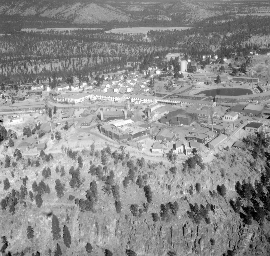
    <summary type="html"><![CDATA[<p><strong><em>From a soggy bog to a beloved community gathering place, the change and continuity of Ashley Pond illustrates the many eras of Los Alamos from homestead to Ranch School to government laboratory to the vibrant community of today.</em></strong></p><img src="https://www.intermountainhistories.org/files/fullsize/474ae326a19e2d428271b8e7a2ab5485.jpg" alt="1946 Aerial View of Los Alamos" /><br/><p><span style="font-weight:400;">Although Ashley Pond is now a prominent green space in the center of Los Alamos, it had a less majestic beginning. In 1908, it was a soggy depression used by homesteader H. H. Brook for watering his stock. Later, the Los Alamos Ranch School used it for the same purpose. Its applicable, albeit unimaginative, first name was the Stock Watering Tank. This was later switched to the Duck Pond in honor of its most popular visitors. The waterhole continued to remain a relatively unimpressive morass until the Ranch School built a dam in Los Alamos Canyon in 1923. This created a small reservoir which fed a pipeline to provide the school with water. The overflow from the pipeline was then dispersed into a puddle which progressively grew into a pond and then a small lake. </p>
<span style="font-weight:400;">The all-boys Los Alamos Ranch School was founded in 1917 by Detroit native, Ashley Pond Jr., who created it to generate tough, intelligent, well-rounded, and experienced outdoorsmen. As such, the students were encouraged to utilize the beautiful landscape for recreation and exercise. The pond provided an ideal place to put their learning into practice. Although never deep enough for true diving, the pond was perfect for canoeing and an excellent place to practice swimming. In the winter, the boys skated across its frozen surface playing hockey and harvesting the ice for the coming year. Ice blocks were stored in a nearby stone ice house and they were known to have collected enough ice to sustain them for up to two years. Once sufficiently filled, school faculty member—and notorious lover of puns—William Mills, provided the name of Ashley Pond in honor of the founder. The official title for the pond is Ashley Pond, not Ashley Pond Pond, but today Los Alamos natives enjoy the humorous anecdote. </p>
<span style="font-weight:400;">When the United States government acquired the land for the Manhattan Project, they allowed the school two months to make other arrangements. The boys went through a hurried graduation and left their beloved mountains, mesas, and pond in the hands of scientists. Manhattan Project staff built the Technical Area, also called TA 1, around the south side of Ashley Pond as a safeguard against fire. They repurposed the ice house as well, using it in 1945 to assemble nuclear components of the “gadget” which would be tested at Trinity. As such, Ashley Pond became restricted under laboratory security and very few outsiders were able to enjoy it. </p>
<span style="font-weight:400;">Today, Ashley Pond is a pleasant downtown landmark of Los Alamos. Situated near the center of town, it is used for picnics, walks, and outdoor concerts in the summer. Los Alamos natives attentively watch the ducks and geese who live at the pond, especially during chick season. During the winter, surrounding trees are decorated with colorful Christmas lights. The local winter parade currently ends at the pond, the same place where the Ranch School boys canoed and harvested ice nearly a century ago. </span>


</p><p><em><strong><a href="https://www.intermountainhistories.org/items/show/750">For more (including 6 images) view the original article</a></strong></em></p>]]></summary>
    <published>2023-09-07T23:39:58+00:00</published>
    <updated>2026-04-17T19:32:16+00:00</updated>
    <link rel="alternate" type="text/html" href="https://www.intermountainhistories.org/items/show/750"/>
    <id>https://www.intermountainhistories.org/items/show/750</id>
    <author>
      <name>Abigail Beus, Brigham Young University</name>
    </author>
  </entry>
  <entry>
    <title type="html"><![CDATA[Back to the Land: New Buffalo ]]></title>
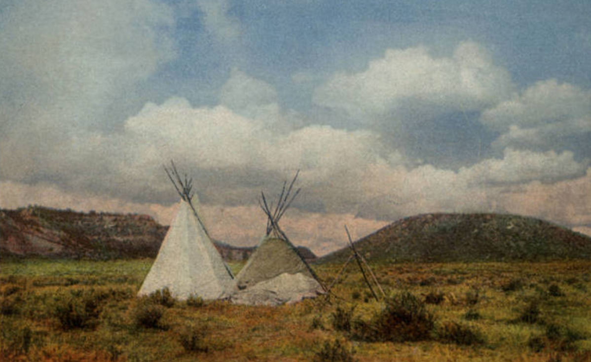
    <summary type="html"><![CDATA[<p><strong><em>New Buffalo was a hippie commune founded in 1967 with the goal of getting back to the land and creating a self-sufficient community. It was emblematic of the Taos area commune scene, which encountered a number of environmental and cultural challenges.</em></strong></p><img src="https://www.intermountainhistories.org/files/fullsize/6dacaae9fe0157eec7e32948bb70d7a4.jpg" alt="Tipis in New Buffalo " /><br/><p><span style="font-weight:400;">During the late 1960s, the US saw an unprecedented explosion of commune formation driven by the hippie counterculture. Alienated by the mainstream conformist, consumption-oriented society, a generation of young people left their places of origin to “tune in and drop out” and “get back to the land.” New Mexico was one of the epicenters for commune development, however the reasons for this are not entirely clear. The climate is harsh and life difficult. Nevertheless, New Mexico had inexpensive land and a reputation for artistic communities around Taos and Santa Fe starting in the early 20</span><span style="font-weight:400;">th</span><span style="font-weight:400;"> century.</span>
<span style="font-weight:400;">In 1967, Rick Klein used his inheritance of $50,000 to purchase 100 acres of land in Arroyo Hondo near Taos and established New Buffalo with a group of friends. They quickly faced several challenges including the loss of their main structure to fire in 1968 and an influx of more residents than the infrastructure could handle. Membership experienced constant turnover and extreme seasonal fluctuations. The residents lived frugally; dozens of inhabitants were supported for only forty dollars per week. Aside from growing their own vegetables and grain, communards hunted their own meat and collected firewood from thirty miles away. </span>
<span style="font-weight:400;">Following New Buffalo, as many as twenty-five communes appeared in the area around Taos and Santa Fe. This influx of new inhabitants had an impact on the local communities. The relationship with local Native Americans was complex. On one hand, some of the communes had good relations with local tribes such as the Taos Pueblo. For example, Klein named New Buffalo in honor of the significance of the buffalo for the Indians, and the members were interested in Indian architectural and sartorial practices and studied the ceremonial use of peyote under Native teachers. However, some scholars have accused the communards of “playing Indian.” </span>
<span style="font-weight:400;">In contrast, the relationship with the local Hispanic population was much more contentious and the area around Taos became the site of the US’s most explosive conflict between local inhabitants and hippies, known locally as the “Hippie-Chicano War.” Nearby Hispanic communities resented the communards, perceiving that they came from prosperous backgrounds yet chose to live in poverty, that they flaunted social norms, that they were unhygienic, sex-crazed dope fiends, and that they might negatively affect the economically important local tourist industry. Incidents such as dynamiting, arson, and telephone threats occurred. The conflict came to a head when one nearby commune member was murdered, two others beaten, and a third raped. Soon after, the pace of commune establishment slowed and cultural conflicts became less salient.</span>
<span style="font-weight:400;">New Buffalo came to public attention when it served as the inspiration for some commune scenes in the film </span><i><span style="font-weight:400;">Easy Rider</span></i><span style="font-weight:400;">, although shooting did not take place on the property itself. By the early 1980s, New Buffalo’s population had dwindled and Rick Klein decided to turn the property into a hippie-themed bed and breakfast referred to as the “Far Out Inn” by the </span><i><span style="font-weight:400;">LA Times</span></i><span style="font-weight:400;">.  It was later purchased by a person interested in preserving the historic site.</span></p><p><em><strong><a href="https://www.intermountainhistories.org/items/show/703">For more (including 5 images) view the original article</a></strong></em></p>]]></summary>
    <published>2023-02-21T14:56:45+00:00</published>
    <updated>2026-04-17T19:32:15+00:00</updated>
    <link rel="alternate" type="text/html" href="https://www.intermountainhistories.org/items/show/703"/>
    <id>https://www.intermountainhistories.org/items/show/703</id>
    <author>
      <name>Evan Železny-Green, Northern Arizona University</name>
    </author>
  </entry>
  <entry>
    <title type="html"><![CDATA[Santo Tomas de Abiquiu: A Genízaro Settlement on the Spanish Frontier]]></title>
    <summary type="html"><![CDATA[<p><strong><em>The town of Santo Tomas de Abiquiu, a Genízaro settlement established in 1754, served as a vital defensive settlement and trading post for Colonial New Mexico. The Genízaros who lived there—formerly enslaved detribalized indigenes—experienced the brutal life of the Spanish imperial frontier.</em></strong></p><img src="https://www.intermountainhistories.org/files/fullsize/c051def285f42825c44765693e65a4be.jpg" alt="Abiquiu in the 1910s" /><br/><p>Throughout the second half of the 18th century, detribalized Native Americans known as Genízaros (pronounced heh-NEE-sah-ros) relocated to land bordering colonial New Mexico and Indigenous territory through a series of land grants from imperial Spain. These settlements played an important role in facilitating trade between New Mexico and Indigenous tribes while also providing a form of colonial defense from other indigenous raiding parties by acting as a buffer zone for the villages of the Rio Chama Valley. The Genízaro settlement of Santo Tomas de Abiquiu was formed in 1754 when Governor Tomas Cachupín issued a land grant to a group of thirty-four Genízaro families. The settlement was about 60 miles north of Santa Fe.
The Genízaros were both Indigenous former slaves and the descendents of former slaves. It was often the case that Indigenous slaves who reached an age of maturity, who married, or whose enslavers released them from their <em>rescate </em>(“ransom and redemption”) debt, received their freedom. These former slaves experienced minimal economic and social mobility. Most had to work menial tasks to survive and were often the poorest members of their communities. Some found success in working as scouts and interpreters, or in Spanish auxiliary military forces. Land grants, like the one that established Abiquiu, were one of the few ways Genízaros could obtain their own property and experience greater economic mobility.
As the Spanish imperials had hoped, Abiquiu throughout its existence served as a buffer against Ute, Navajo, and Comanche raids. And like other Genízaro settlements Abiquiu also became an important waypoint for trade with other indigenous peoples, and Abiquiu became an important frontier trading post. Thanks to a treaty of friendship negotiated between Governor Cachupín and the Ute people, Abiquiu became the site of Ute trading fairs, especially in the late autumn months. In 1786, Spain the the Comanche signed a treaty to further trade between the people of Abiquiu and other Indigenous groups.
Despite the important role Genízaro settlements played as a link between Colonial Spain and Indigenous groups, Genízaros and Spanish settlers had a fraught relationship. A series of witch trials, originating in Abiquiu and spreading throughout the region, revealed the tensions that existed both between Spaniards and Genízaros, as well as the tensions that existed between Genízaros of differing beliefs and cultural/tribal backgrounds. Genízaros made up both accused and accusers, and Spanish inquisitorial courts condemned many Genízaros’ traditional spiritual beliefs as satanic. In the end, the Inquisition never executed any accused Genízaro, but inquisitors did torture many and sentence others to perpetual servitude in Spanish Catholic homes, revealing the fragility of Genízaro freedom.
More recently, Abiquiu has been the site of important Indigenous land right battles. While the United States’ Court of Private Land Claims validated the Genízaros’ 16,000 acre land grant in 1894, some disputes over dispossessed Genízaro land remained unresolved for nearly a century. In 1969, the United States returned National Forest lands to Genízaro families, in part thanks to help from the Presbyterian Church. Later, in 2008, New Mexico expanded the land they recognized as part of the historical grant and returned another 32.5 acres to the Genízaro community.</p><p><em><strong><a href="https://www.intermountainhistories.org/items/show/631">For more (including 3 images) view the original article</a></strong></em></p>]]></summary>
    <published>2022-07-01T01:02:07+00:00</published>
    <updated>2026-04-17T19:32:13+00:00</updated>
    <link rel="alternate" type="text/html" href="https://www.intermountainhistories.org/items/show/631"/>
    <id>https://www.intermountainhistories.org/items/show/631</id>
    <author>
      <name>Jacob Morrison, Brigham Young University</name>
    </author>
  </entry>
  <entry>
    <title type="html"><![CDATA[Santa Fe Trail’s Indigenous Origins]]></title>
    <summary type="html"><![CDATA[<p><strong><em>The Santa Fe Trail was a conduit of trade in the Americas controlled by the Comanches and Utes.</em></strong></p><img src="https://www.intermountainhistories.org/files/fullsize/904510e761af8d3ad907e44dde960226.jpg" alt="Braves and their steeds" /><br/><p>The Santa Fe Trail is one of the symbols of American westward expansion and Manifest Destiny. The trail runs from Independence, Missouri to Santa Fe, New Mexico and was a major artery of trade between American pioneers, Mexican settlers, and most significantly, indigenous peoples. For decades before and throughout its history, the trade along the Trail was controlled by its main beneficiary: the Comanche nation.
The first man to make the journey from Santa Fe to Independence in the late 1700s was Pedro Vial, a Frenchman who had lived among the Comanche and was on peaceful terms with the powerful nation. Most Comanche–American relations around the advent of the 19<sup>th</sup> century were friendly and trade-based because of the Comanche’s ambitions for economic expansion. To the delight of the Comanche, declining Spanish colonial power in the American Southwest culminated in Mexican independence in 1821, sweeping away barriers to trade/
Through utilizing Spanish horses and raiding tactics, the Comanche had already established themselves as the dominant force in the Southwest. This was evident through the significant contractions of the neighboring tribes and the Spanish colonists themselves. An American officer, General Stephen Long, was the subject of a second-hand account of Comanche-Spanish conflict in the nineteenth century: “It was stated last fall by the Spanish officers at the Sabine, who were attached to the Spanish expedition against Gen. Long and his followers, that those Indians had, within the last season, destroyed upwards of 1000 families on the Rio del Norte, and in parts of the Spanish provinces.” The Americans recognized that the Comanche were a force to be respected.
While the Comanche could be brutal to those who didn’t cooperate with their terms, the Santa Fe trade flourished under their control. Tens of thousands of dollars of goods moved along the trail between 1820 and 1840. American traders like Josiah Greggs and Thomas James learned to pay for their passage and abide by Comanche rules and traditions, and they profited for years off of their economically beneficial friendship. James himself was even adopted into a Comanche tribe as a result.
Unfortunately for many American and Mexican settlers along the trail—therefore in Comanche territory—this meant Comanche tributary demands. When these demands for tribute or trade were not met, settlers suffered the consequences. Entire settlements in present-day Texas and New Mexico were destroyed because of their lack of cooperation with Comanche trade policy.</p><p><em><strong><a href="https://www.intermountainhistories.org/items/show/590">For more (including 3 images) view the original article</a></strong></em></p>]]></summary>
    <published>2022-04-16T00:16:42+00:00</published>
    <updated>2026-04-17T19:32:12+00:00</updated>
    <link rel="alternate" type="text/html" href="https://www.intermountainhistories.org/items/show/590"/>
    <id>https://www.intermountainhistories.org/items/show/590</id>
    <author>
      <name>Joshua Rust, Brigham Young University</name>
    </author>
  </entry>
  <entry>
    <title type="html"><![CDATA[Camels at Fort Defiance]]></title>
    <summary type="html"><![CDATA[<p><strong><em>The US government brought camels to the Southwest to use them in the short-lived US Camel Corps, formed in 1857 and lasting until 1863, which experimented with the pack animals for military use. Lieutenant Edward Fitzgerald Beale used them to survey a wagon route from Fort Defiance to the Colorado River, charting the “dim, uncertain, and unknown.”</em></strong></p><img src="https://www.intermountainhistories.org/files/fullsize/746aac8579a2592361a2a2a65a514dba.jpg" alt="Camel camp" /><br/><p>Fort Defiance marks the starting point of Lieutenant Edward Fitzgerald Beale’s 1857–1858 wagon road survey across the 35th parallel to the Colorado River, the very first deployment of the US Camel Corps. The government was eager to boost the efficiency of transport and trade between the East and California and furthermore wanted to survey the land acquired from the Mexican government after the Mexican–American War. Recommendations by military officials such as Major Henry C. Wayne eventually resulted in two shipments of camels, as well as camel handlers such as the Arizona-famous Hi Jolly, docking at Indianola, Texas, on May 14, 1856. From there they were moved to a fort near San Antonio. Lieutenant Beale, appointed by Major Wayne to use this Camel Corps for the wagon road survey, set out from San Antonio with twenty-eight camels on June 25, 1857.
Along the way to Fort Defiance, Lieutenant Beale was to meet up with a Colonel Loring, a general who had lost one arm in the Mexican War and would later go on to help train troops in Egypt. At this early date, however, he was unacquainted with camels, and Beale rather literally left him in the dust, as the camel Beale was riding easily outpaced Loring’s horse. They met back together some two days later and reached Fort Defiance together on August 25, 1857.
Colonel Edwin Vose Sumner established Fort Defiance to assert dominance over the Navajo population with a military presence. Lacking defensive fortifications, however, it took the form of a “military village,” with barracks, stables, storehouses, a civilian trading store, a hospital, and a structure for Navajos staying overnight, all arrayed around a parade ground. At this time, the fort held a tentative peace with the Native Americans of the region. They traded with the Zuni and the Navajo for food, but the fort occupied what had been grazing land, and occasional raids continued. While 1856–1857 was relatively quiet around the vicinity of the fort, Beale’s careful notes of any Native American sightings or interactions on his journey demonstrate the government’s uneasy relationship with the native inhabitants of the territory.
When he reached Fort Defiance, Beale wrote in his journal that “No one who has not commanded an expedition of this kind, where everything ahead is dim, uncertain, and unknown, except the dangers, can imagine the anxiety with which I start upon this journey.” Beale himself had already led an expedition such as this, charting a “Central Route” to California in 1853 from Missouri. Seeing the camels’ performance on this expedition from Fort Defiance left Beale with great admiration for their ability to carry enormous loads, travel great distances, and go long periods of time without water. He even developed a particular affinity for one camel named Seid.  Even after the Camel Corps was officially disbanded, Beale kept a collection of camels at his ranch near Fort Tejon, California.</p><p><em><strong><a href="https://www.intermountainhistories.org/items/show/525">For more (including 5 images) view the original article</a></strong></em></p>]]></summary>
    <published>2021-10-20T09:06:17+00:00</published>
    <updated>2026-04-17T19:32:11+00:00</updated>
    <link rel="alternate" type="text/html" href="https://www.intermountainhistories.org/items/show/525"/>
    <id>https://www.intermountainhistories.org/items/show/525</id>
    <author>
      <name>Emily Moore, Northern Arizona University</name>
    </author>
  </entry>
  <entry>
    <title type="html"><![CDATA[Chief Barboncito and The Treaty of 1868]]></title>
    <summary type="html"><![CDATA[<p><strong><em>After years of displacement and internment, negotiations between Chief Barboncito and the United States government resulted in a treaty that allowed the Navajo to returned to their homeland in the Four Corners region.</em></strong></p><img src="https://www.intermountainhistories.org/files/fullsize/acdbc3e43efc463260bb43435470b6cc.jpg" alt="Treaty marker" /><br/><p>Navajo Chief Barboncito (1821–1871) played an important role in the negotiations that helped the Navajo return to the Four Corners region in 1868. Fluent in Navajo and Spanish, Barboncito communicated with US negotiators, who used translators that were fluent in English and Spanish, to draft a dual language treaty that would allow the Navajo to return home, making them the first American Indian tribe able to do so.
The Navajo had lived in Bosque Redondo from 1864–1868. Arriving by forced relocation that put an end to the Navajo Wars at the command of General James Carleton and carried out by Colonel Christopher “Kit” Carson, the Navajo internment camp refinement period proved to be a failure due to the high cost required to maintain provisions to keep the Navajo alive. Due to poor soil conditions and resource constraints, the United States needed to rethink their role in confining the Navajo.
In addition to negotiating with the United States regarding Navajo internment, Barboncito was also a spiritual leader and medicine man who gained prominence alongside Chief Manulito and Ganado Mucho due to their diplomacy and oratory skills. When it came time to discuss treaty provisions, Barboncito rejected General William Sherman’s offer to relocate the Navajo to Indian Country in Oklahoma. Fearing that Oklahoma would be similar to Bosque Redondo, Barboncito advocated on behalf of himself and the 9,000 other Navajo that they would be a peaceful people upon their return home, declaring that the area between the four sacred mountains was created and given to them by their gods, First Man and First Woman, solely for them.
The treaty was signed and made official on June 1, 1868. After returning home and following the creation of the Navajo reservation system, Barboncito kept his word, and the Navajo no longer engaged in warring behavior against neighboring white settlements. Compared to the initial reservation boundary, the territory has since tripled in size, currently covering an area the size of West Virginia. The Navajo today can enjoy their ancestral land and continue to teach their traditions and cultures thanks to men like Chief Barboncito.</p><p><em><strong><a href="https://www.intermountainhistories.org/items/show/488">For more (including 3 images) view the original article</a></strong></em></p>]]></summary>
    <published>2021-09-16T22:05:02+00:00</published>
    <updated>2026-04-17T19:32:10+00:00</updated>
    <link rel="alternate" type="text/html" href="https://www.intermountainhistories.org/items/show/488"/>
    <id>https://www.intermountainhistories.org/items/show/488</id>
    <author>
      <name>Colin Tompson, Brigham Young University</name>
    </author>
  </entry>
  <entry>
    <title type="html"><![CDATA[The Kuaua Pueblo Ruins and the Coronado Historic Site]]></title>
    <summary type="html"><![CDATA[<p><strong><em>During Francisco Vasquez de Coronado’s expedition to New Mexico in the 1540s, he came into contact with the Tiwa people who lived in pueblos near modern-day Albuquerque. In the 1930s, archaeologists excavated the ruins of Kuaua, one of the largest pueblos. These ruins currently constitute a large part of the Coronado Historic Site.</em></strong></p><img src="https://www.intermountainhistories.org/files/fullsize/abc8c5fc50ca9f4f5d8bae95e244cdb1.jpg" alt="Kuaua ruins, Coronado State Monument, 1940" /><br/><p>Archaeologists located the Kuaua Pueblo ruins just north of Albuquerque, New Mexico along the banks of the Rio Grande River. Created as part of the 400th anniversary of Francisco Vasquez de Coronado’s entry into New Mexico, the Coronado History Site references the expedition’s interactions with local Tiwa villages. Kuaua, a name meaning “evergreen” in Tiwa, was one of the largest of these villages and may have been the site of Coronado’s winter headquarters during the expedition. Archaeologists have estimated that the Tiwa settled this village in the fourteenth century and likely contained more than one thousand people when they came into contact with Coronado. However, conflict over the years with Coronado and other Spanish explorers eventually led to the Tiwa’s abandonment of Kuaua Pueblo in the sixteenth century.</p><p>When the archaeological team excavated the Kuaua Ruins in the 1930s, they uncovered more than 1,200 adobe rooms, three ceremonial rooms, and six kivas. Several of the kivas contained a series of murals that many revere today as some of the best examples of Pre-Columbian artwork in the United States. Kuaua religious murals flourished throughout the fourteenth, fifteenth, and sixteenth centuries, reflecting religious and cosmological iconography such as references to rain, rainbows, clouds, lightning, and ritual figures engaging in rain-making rituals. These rituals formed an important part of Pueblo culture and religion due to the region’s general climate of minimal precipitation. </p><p>Thanks to extensive conservation efforts since the 1930s, the murals have been preserved for modern viewing. The Coronado Historic Site includes a Visitor Center, which features fourteen examples of original mural artwork as well as Pueblo Indian and colonial Spanish artifacts. Several trails throughout the ruins of the pueblo and along the Rio Grande River provide exploration opportunities for visitors wishing to more authentically learn about the Tiwa Pueblo culture and lifestyle.</p><p><em><strong><a href="https://www.intermountainhistories.org/items/show/404">For more (including 3 images) view the original article</a></strong></em></p>]]></summary>
    <published>2020-03-11T22:43:42+00:00</published>
    <updated>2026-04-17T19:32:08+00:00</updated>
    <link rel="alternate" type="text/html" href="https://www.intermountainhistories.org/items/show/404"/>
    <id>https://www.intermountainhistories.org/items/show/404</id>
    <author>
      <name>Sarah Rounsville, Brigham Young University</name>
    </author>
  </entry>
  <entry>
    <title type="html"><![CDATA[AIM Occupation of Fairchild Plant on Navajo Reservation]]></title>
    <summary type="html"><![CDATA[<p><strong><em>Activism plays a significant role in improving employment quality and longevity, but situations like the occupation of the Fairchild Plant on the Navajo Reservation causes people to question whether or not activism is the best method to achieve such goals.</em></strong></p><img src="https://www.intermountainhistories.org/files/fullsize/f881a04cf0a41c0bb4ee8d31723f525d.jpg" alt="Ribbon cutting at Fairchild Building Dedication, 1969" /><br/><p>In the early 1960s, unemployment on the Navajo Reservation hovered around 40% and Tribal leadership desperately tried to create jobs for Diné peoples. In 1964, Tribal chairman Raymond Nakai advocated for better economic development on the reservation and – hoping to attract outside investment – opened up the Navajo Nation to outside businesses. To further entice companies, the tribe offered $1 million toward development to any company willing to relocate. Fairchild Camera and Instrument Corporation responded to the offer and decided to build a plant in Shiprock, New Mexico and provide housing for tribal members who helped with construction. After its completion, Fairchild employed more than a thousand workers (the majority being female) and provided consistent jobs for ten years. </p><p>In the early 1970s, however, the country’s economy lagged, affecting companies like Fairchild. Many of the workers in Shiprock faced reduced paychecks or even termination. According to one Navajo account, the plant manager said, “This is a business venture, not a charitable activity.” The weakened economy combined with news of the plant’s financial solution wounded the community’s morale. The American Indian Movement (AIM) – an organization founded during the Civil Rights Era that fought for indigenous communities’ rights – heard about the situation and decided to intervene. Protestors including activist Russell Means came to Shiprock and laid siege to the plant on behalf of the underpaid and dismissed workers. The protestors demanded that Fairchild rehire the workers and restore their paychecks to pre-reduction rates. However, some local Natives considered this protest against the company dangerous and unnecessary. </p><p>Fairchild refused AIM’s conditions and let the tribal government handle the matter. However, the tribal government did not help overcome the impasse and the siege ultimately shut down the plant. Fairchild executives expressed frustration over how the tribe handled the situation and withdrew from the reservation altogether, relocating their operations to Korea. Some AIM supporters perceived this result as a victory, but locals recognized the great loss of employment opportunity alongside a damaged reputation for future incoming businesses on the Navajo Reservation. Even today, these consequential outcomes continue to have a harmful effect on Navajo employment.</p><p><em><strong><a href="https://www.intermountainhistories.org/items/show/398">For more (including 3 images) view the original article</a></strong></em></p>]]></summary>
    <published>2020-03-06T23:38:51+00:00</published>
    <updated>2026-04-17T19:32:08+00:00</updated>
    <link rel="alternate" type="text/html" href="https://www.intermountainhistories.org/items/show/398"/>
    <id>https://www.intermountainhistories.org/items/show/398</id>
    <author>
      <name>Elias Gold, Brigham Young University</name>
    </author>
  </entry>
  <entry>
    <title type="html"><![CDATA[Kit Carson’s 1864 Interactions with Navajos]]></title>
    <summary type="html"><![CDATA[<p><strong><em>Kit Carson’s siege of Canyon de Chelly led to the Long Walk relocation of the Navajo peoples. Having since returned to their homeland, the Navajos have proved their endurance through conquest and cultural genocide.</em></strong></p><img src="https://www.intermountainhistories.org/files/fullsize/8a4e53e9ca09e9d130768a68addeb683.jpg" alt="Navajo on Long Walk" /><br/><p>The natural fortress of Canyon de Chelly in modern-day Arizona housed was one of the largest gatherings of Navajo, or Diné, people. The area supported many family communities and contained plentiful resources. Early explorers even considered Canyon de Chelly a dangerous area because of the enormous Navajo population. However, as immigrants moved west in the early nineteenth century, the Navajos faced oppression from settlers and United States military forces. By the 1860s, the Navajos had encountered these groups on multiple occasions and frequently negotiated trade, land inquiry, and intertribal relations. </p><p>Indian agent Christopher “Kit” Carson primarily handled dealings between the federal government and Navajo people. The U.S. government authorized a campaign of total warfare against the Navajos to limit their independence and force their removal from the territory. Kit Carson was instructed to lead attacks against various communities of Navajo families and, in 1864, accomplished this goal by cutting off natural resources, exterminating food and shelter, gathering the Navajos together and communally leading them away from their traditional homelands, and incarcerating opposing forces. </p><p>Skirmishes and confrontations between the two parties led to the largest tribal surrender in American history. After a month of conflict, Kit Carson and his armies initiated the Navajo Long Walk, a 250-450-mile journey from their homeland to internment camps at Bosque Redondo in New Mexico.  </p><p>The Long Walk remains a defining moment in Diné history. Navajo war leaders and federal government authorities such as William T. Sherman convened to negotiate the future of the relocated Navajo people. The Navajo Treaty of 1868 allowed survivors to return to their traditional homelands and start over. The destruction at Canyon de Chelly and the subsequent removal caused permanent damage to Navajo family structures and instigated a gradual cultural genocide. Despite their significant losses of population, the Navajo people have managed to withstand the legacy of conquest by preserving their culture and homeland. The Navajos are the largest group of American Indians today.</p><p><em><strong><a href="https://www.intermountainhistories.org/items/show/394">For more (including 4 images) view the original article</a></strong></em></p>]]></summary>
    <published>2020-03-02T22:52:45+00:00</published>
    <updated>2026-04-17T19:32:07+00:00</updated>
    <link rel="alternate" type="text/html" href="https://www.intermountainhistories.org/items/show/394"/>
    <id>https://www.intermountainhistories.org/items/show/394</id>
    <author>
      <name>Sheiyenne Baloo, Brigham Young University</name>
    </author>
  </entry>
  <entry>
    <title type="html"><![CDATA[Tragedy at Church Rock: Superfunds and the Marginalization of Navajos]]></title>
    <summary type="html"><![CDATA[<p><strong><em>In 1979 the United Nuclear dam in New Mexico failed and released over 1,000 tons of radioactive waste, greatly harming the Navajo community at nearby Church Rock. </em></strong></p><img src="https://www.intermountainhistories.org/files/fullsize/24fb43a1f523a53719f4159e884c1d1d.jpg" alt="Church Rock Dam Breach" /><br/><p>Before sunrise on July 16, 1979, Navajos who resided in Church Rock, New Mexico, awoke to the sound of rushing water. They were confused, for there had been no rain to cause flooding of the nearby Puerco River. Unbeknownst to them, a nearby dam owned by United Nuclear had failed, releasing 95 million gallons of mine waste into the local water systems. This waste contained 1,100 tons of radioactive waste from a mill that processed uranium, killing sheep that drank it and burning the feet of children who waded in it. United Nuclear temporarily closed the mill and immediately the Indian Health Services urged people not to drink the water, but without assistance many poor families had no other options. Shortly after, the CDC tested the radiation levels of just six people, and when their results weren’t alarming, declared that no major threat to public health existed due to the spill. In spite of this, the Navajo Nation appealed to the state’s governor to declare a state of emergency in the Church Rock area, a request that was denied. However, when United Nuclear threatened to start laying people off if the mill remained closed, the state and federal government quickly complied to let mill operations resume just five months after the massive spill. The spill, and effects from the mill’s continued operation after, landed the Church Rock on the National Priority List for Superfund sites in 1983.</p><p>The neglect of Navajo lands is evident when one compares the response to another nuclear accident that happened just four months prior at Three Mile Island in Pennsylvania. A partial nuclear meltdown led to the evacuation of 140,000 people and to the state declaring a state of emergency, even though the release of nuclear radiation was significantly less than at Church Rock. Many government funded investigations were commissioned to understand the causes and the long-lasting effects of the accident in Pennsylvania, but such studies do not exist for the Navajo at Church Rock. The failure of United Nuclear’s dam was no mystery; cracks were reported in the 75-foot earthen structure nearly two years prior to the spill, but no action was taken. United Nuclear efforts to clean amounted to the removal of 3,500 tons of contaminated soil downstream, estimated to be just 1% of the total affected soil.</p><p>The site’s designation as a Superfund has hardly been effective at providing meaningful assistance. After 36 years as a Superfund, the EPA’s website still reports today that “groundwater contamination, and the migration of contaminated groundwater is not stabilized.” Many Navajos have long given up hope of government assistance. They have formed grassroots organizations like Eastern Navajo Diné Against Uranium Mining to prevent future mining operations and aid contaminated areas. In 2017, the ENDAUM discovered a small Navajo community was still using contaminated water to hydrate and bathe their livestock. They found hairless sheep and insides of cows that had turned yellow. The Navajo had to burn the sick animals to avoid further contamination. Even though there is a lack of scholarly investigation on the effects of the spill, the experiences of Navajo show the terrible consequences on local health. One Navajo remarked on the high cancer rates in the reservation: “That’s why we drink. We think we won’t live long.” This has negative implications for the future Navajo, as one resident of Church Rock commented, “Our generation is afraid of having children. Cancer runs in our family, but it shouldn't.” </p><p>Americans generally don’t view pollution positively, but the time of putting production and profits over human lives must end. The current presidential administration values economic potential over the environment and public health, a trend that does not bode well for the neglected Navajo. The Navajo Nation deserves the reparation that disasters like the Church Rock spill demand as well as protection from future exploitation. </p><p><em><strong><a href="https://www.intermountainhistories.org/items/show/379">For more (including 3 images) view the original article</a></strong></em></p>]]></summary>
    <published>2020-01-08T22:11:58+00:00</published>
    <updated>2026-04-17T19:32:07+00:00</updated>
    <link rel="alternate" type="text/html" href="https://www.intermountainhistories.org/items/show/379"/>
    <id>https://www.intermountainhistories.org/items/show/379</id>
    <author>
      <name>Sam Heywood, Brigham Young University</name>
    </author>
  </entry>
</feed>