<?xml version="1.0" encoding="UTF-8"?>
<feed xmlns="http://www.w3.org/2005/Atom">
  <title type="text">Intermountain Histories</title>
  <updated>2026-08-18T15:52:16+00:00</updated>
  <generator uri="http://framework.zend.com" version="1.12.20">Zend_Feed_Writer</generator>
  <link rel="alternate" type="text/html" href="https://www.intermountainhistories.org/"/>
  <link rel="self" type="application/atom+xml" href="https://www.intermountainhistories.org/items/browse?output=rss2"/>
  <id>https://www.intermountainhistories.org/</id>
  <author>
    <name>Intermountain Histories</name>
    <uri>https://www.intermountainhistories.org</uri>
  </author>
  <link rel="hub" href="https://pubsubhubbub.appspot.com/"/>
  <entry>
    <title type="html"><![CDATA[Fort Bridger and the Donner Party]]></title>
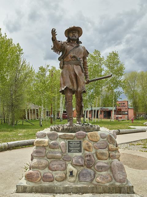
    <summary type="html"><![CDATA[<p><strong><em>On July 20th, 1846, a group of families on an emigrant train in present-day Wyoming separated from the main party to take a supposed shortcut that would expedite their journey to the Mexican territory of Alta California. This group known as the Donner Party started their journey on the cutoff with the goal of reaching Fort Bridger, which would be the point of no return on their ill-fated journey. </em></strong></p><img src="https://www.intermountainhistories.org/files/fullsize/e6c5db8e3d5e018d3b0a52d9335af3ff.jpg" alt="Statue of Jim Bridger at the Fort Bridger Historic Site" /><br/><p>Mountain men and adventurers Jim Bridger and Louis Vasquez established this fort in modern-day southwest Wyoming in 1842. Originally built as a trading post to service and profit off the rush of the trappers heading West, it found purpose as a resupply point for emigrant parties heading to California. While the word “fort” brings to mind high stone walls, a California-bound party led by Edwin Bryant in early 1846 described Fort Bridger as <i>“two or three miserable log cabins, rudely constructed, and bearing but a faint resemblance to habitable houses.”</i> The Donner Party reached Fort Bridger on July 27th, 1846. Earlier on the trail, the party had received letters from Lansford Hastings, the author of the cutoff. He advertised it as an alternative and shorter route, and said that if they met him at Fort Bridger, he would guide them through it. Despite James Clyman’s warnings of the cutoff to James Reed, a father of 6 and leader of the party, the allure of time and distance saved proved seductive. According to survivor reports, James Reed believed that the route would save them <i>“350 or 400 miles” </i>and relayed that Bridger had described it as ”<i>a fine, level road with plenty of water and grass.”</i> It is theorized that Bridger, a seasoned mountain man, knew of the danger of the cutoff but goaded them on regardless to increase emigrant traffic through his fort. After repairs, restocking, and rest, the Donner party left Fort Bridger on July 31st. Growing from around 60 members to 74 because of the addition of the McCutchen family and several teamsters. They proceeded towards the Wasatch Mountains in modern-day Utah. Emigrant parties continued to utilize Fort Bridger for the following decade, but the Donner party remains one of the most influential to do so. The fort remained operational until Bridger's run-ins with the law caught up to him, including an arrest warrant issued from Salt Lake City, Utah for <i>“furnishing the Indians with powder and lead to kill Mormons.”</i> The fort was sold to the Church of Jesus Christ of Latter-Day Saints (or Mormons) in 1855, with the church having documents of its sale from Vasquez representing both him and Bridger. The Saints held onto this fort until November of 1857. President James Buchanan sent an army commanded by General Albert S. Johnston to suppress a supposed Mormon rebellion. In preparation the saints burned several buildings before retreating to Echo Pass in Utah. Following its abandonment by the Saints, the fort was seized by the United States military, where it saw its commanders switch hands for decades. It found use as a staging area for military exercises against Native Americans and general military travel during the mid 19th century. As the years passed, the land under Fort Bridger’s jurisdiction became smaller as the threat of attacks from Native Americans subsided. It was abandoned on October 1st, 1890. This trading post, fort, and military depot served as a landmark for Western history as emigrants, natives, and mountain men all crossed its path. For the Donners, it served as their final resupply point, and for many the last semblance of civilization they would ever see. For the next 760 miles, the Donners would travel through rough mountain passes and barren salt deserts with minimal rest and resupply. The ill-intentioned words of Hastings and Bridger would prove to be a death sentence.</p><p><em><strong><a href="https://www.intermountainhistories.org/items/show/940">For more (including 6 images) view the original article</a></strong></em></p>]]></summary>
    <published>2026-02-02T17:23:00+00:00</published>
    <updated>2026-04-17T19:32:21+00:00</updated>
    <link rel="alternate" type="text/html" href="https://www.intermountainhistories.org/items/show/940"/>
    <id>https://www.intermountainhistories.org/items/show/940</id>
    <author>
      <name>Samuel Watson, Brigham Young University</name>
    </author>
  </entry>
  <entry>
    <title type="html"><![CDATA[The Donner Party at Fort Laramie]]></title>
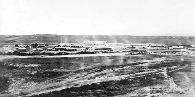
    <summary type="html"><![CDATA[<p><strong><em>	On June 27th, 1846, George Donner led a group of westward-bound emigrants from Illinois into Fort Laramie in what is now eastern Wyoming, but then unorganized territory. Fort Laramie was considered the doorway to the Intermountain West for travelers on the Overland Trail. For the Donners it would be considered the doorway to the first of many errors which made them the most infamous pioneers in American history.</em></strong></p><img src="https://www.intermountainhistories.org/files/fullsize/ff3f6be2d77dcfcaf49158dc57b9c4cc.jpg" alt="The Fort Laramie property photographed in 1877" /><br/><p>Fur trapper and trader William Sublette originally constructed the Fort in 1834. Emigrant trains and trappers used it as a stopping point and resupply station between the West and the East. It was here that the Donner party made a disastrous route decision to take an untested trail which would lead to their downfall and infamy.
The Donner family was from Illinois, and like other emigrant parties, knew little of the Western terrain outside of maps and journals. Before the Donners’ arrival, mountain men, fur trappers, and explorers had been devising routes westward out of Fort Laramie for emigrants to quickly and ‘safely’ travel to Oregon Country (which the U.S. co-managed with Great Britain) or the present-day areas of California that were then part of the larger Mexican territory of Alta California. The decision to stray from the traditional route was based on Lanford Hastings’ 1845 <em>The Emigrants guide to Oregon and California. </em>An explorer and eventual confederate soldier, Hastings described a westward route variation that would become known as the “Hastings Cutoff.” He wrote that the traditional route to get to central California could be hastened if one were to cut through the deserts of present-day western Utah and Nevada (then part of Mexican Alta California) instead of going north through present-day Idaho (then part of Oregon Country). They relied on the words of explorers like Hastings while planning their journey, even if the validity of these claims were yet untested.
Fearing the viability of Hastings Cutoff, famed mountain man James Clyman told one of the leaders of the party at Fort Laramie, James Reed, to “<em>take the regular wagon track and never leave it–it is barely possible to get through if you follow it–and it may be impossible if you don’t.</em>” Clyman’s warning fell on deaf ears. After leaving Fort Laramie in early July, many families decided to take the Hastings Cutoff. This decision proved fatal, eventually resulting in the death of 40 emigrants by the Spring of 1847. With George Donner chosen as the group’s captain, the collection of families that followed his lead to the Hastings Cutoff bear his name. The families that chose to take the Hastings Cutoff elected George Donner as its leader, with the group bearing his name. At Fort Bridger, in present-day southwestern Wyoming, they diverted southwest on the cutoff whereas the main company led by Lilburn W. Boggs continued on the traditional route which turned northwest from Fort Bridger towards Fort Hall in present-day southeastern Idaho. The Boggs party arrived safely in California in November 1846. The Donner Party did not.
The fort continued to play a role in migration, trading, and military activities in the years to come. Notable groups to pass through were the Latter-Day Saint migration of 1847, the gold rush of 1849, and the establishment of a military post in July of 1849. It became the site of several treaties signed between the federal government and Native Americans designed to reduce violence against emigrant trains. The Donner Party had not had conflicts with Native Americans on the plains, even though it was a concern for emigrants leading up to Fort Laramie. The Donners didn’t know it yet, but the decisions made here would lead to massive time loss, conflicts with Native Americans, and a heavy toll on their emotional health.</p><p><em><strong><a href="https://www.intermountainhistories.org/items/show/931">For more (including 7 images) view the original article</a></strong></em></p>]]></summary>
    <published>2026-02-02T17:19:19+00:00</published>
    <updated>2026-04-17T19:32:21+00:00</updated>
    <link rel="alternate" type="text/html" href="https://www.intermountainhistories.org/items/show/931"/>
    <id>https://www.intermountainhistories.org/items/show/931</id>
    <author>
      <name>Samuel Watson, Brigham Young University</name>
    </author>
  </entry>
  <entry>
    <title type="html"><![CDATA[Theodore Roosevelt&#039;s Ride Through the Cowboy State: Story 5 of 8 of the President Theodore Roosevelt in the West Tour]]></title>
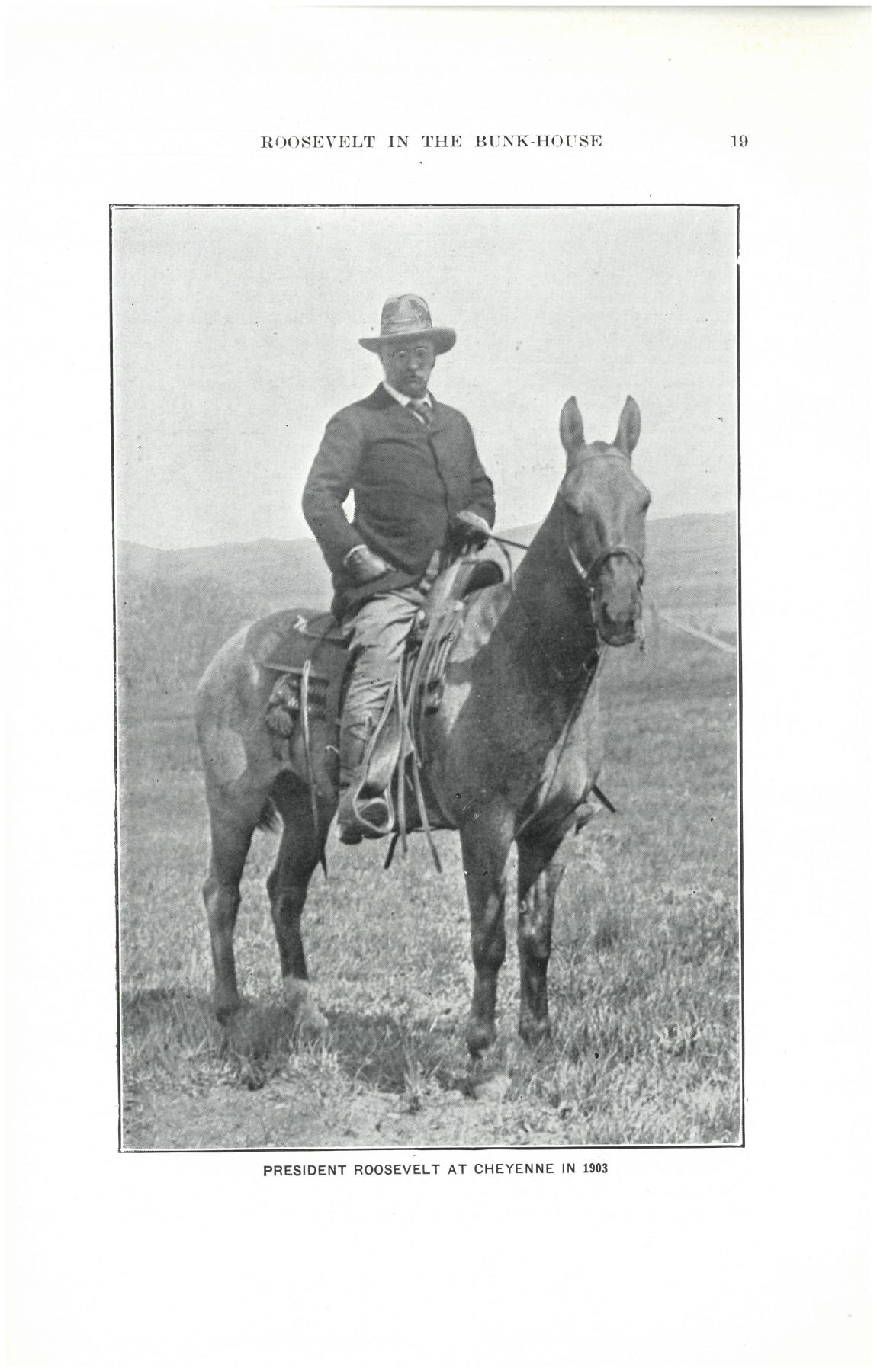
    <summary type="html"><![CDATA[<p><strong><em>President Theodore Roosevelt's iconic horseback ride from Laramie to Cheyenne to greet the veterans and citizens of Wyoming.</em></strong></p><img src="https://www.intermountainhistories.org/files/fullsize/60adc8f5c3838543347d6d16506e64cc.jpg" alt="President Roosevelt mounted on Ragalon, a horse who could count, bow, roll over, and distinguish colors. It was a “fine galloper and a speedy trotter.” " /><br/><p>President Theodore Roosevelt had a penchant for the dramatic in his public persona. His 1903 visit to Wyoming and May 31 speech commemorating Decoration Day (Memorial Day) was no exception.
Upon arrival in Evanston, Wyoming, via train from the west, President Theodore Roosevelt was greeted by a crowd of 7,000 peoplegathered from Wyoming and surrounding states to see the Commander in Chief. After a short visit, he continued east to Laramie, Wyoming. From there, he rode the remaining 65 miles to Cheyenne, Wyoming, on horseback. Along the way, he changed horses four times with prominent citizens like Senator Francis E. Warren and famous lawman and Black Hills Forest Reserve Supervisor Seth Bullock.Senator Warren, in a telegram, said it would be a “long, hard ride,”and indeed it was. Familiar with risk and discomfort, and always eager to make a dramatic scene, Roosevelt’s party emerged from a mountain valley near Telephone Canyon and was greeted by a crowd in Cheyenne. The Cheyenne Daily Leader later wrote, "The West was written in every line of his frame," alluding to Roosevelt’s strong connection with the land and spirit of the West. The stunt exemplified his well-known advocacy for the “strenuous life” and love of the West. Having “waved all possible objections” to overcome the difficulties he might have encountered, Roosevelt felt the West as a very restorative place. At the lowest point in his life, when his mother and wife died the same day, he had “lost the light” in his life but found it again in the American West.
Nearly 20,000 citizens gathered in Cheyenne to hear the President speak on May 31, 1903. Reflecting on his horseback arrival, he stated his desire “not to strive to find out the things that are easiest to do, but the things that are best worth doing.” The crowd included Civil War veterans in both Confederate gray and Union blue uniforms. With them in view, he emphasised the importance of national unity. Referring to the their wartime service, he declared “You don’t care where that man’s birthplace has been; you don't care a snap of your fingers how he worshiped his Maker; you don't care whether he was a banker, bricklayer, lawyer, mechanic, or farmer” Perhaps hoping to point to bridging divides between former enemies, he continued, “It is the same thing now in civil life.”His message was well-received, and the citizens reflected that sense of community with a frontier twist. A handsome cowpony, Ragalon, was gifted to Roosevelt with a specially made saddle, bridle, and blanket. Roosevelt was also entertained with an impromptu frontier show and many barbecues during his stay. 
This time in Wyoming marked the value Roosevelt had for veterans and small towns in America. His personability with common Americans, honored veterans included, helped boost his popularity in the subsequent 1904 election. Roosevelt loved the West, and the West loved him back.</p><p><em><strong><a href="https://www.intermountainhistories.org/items/show/922">For more (including 4 images) view the original article</a></strong></em></p>]]></summary>
    <published>2025-10-24T15:03:18+00:00</published>
    <updated>2026-08-18T15:52:16+00:00</updated>
    <link rel="alternate" type="text/html" href="https://www.intermountainhistories.org/items/show/922"/>
    <id>https://www.intermountainhistories.org/items/show/922</id>
    <author>
      <name>Jessika Cole, Brigham Young University</name>
    </author>
  </entry>
  <entry>
    <title type="html"><![CDATA[Kemmerer, Wyoming Alcohol Culture during Prohibition]]></title>
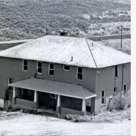
    <summary type="html"><![CDATA[<p><strong><em>Kemmerer, Wyoming emerged in the late nineteenth century when Patrick J. Quealy founded a coal company and a town to go with it. Kemmerer was popular among immigrant business owners who set up shops seeking financial and personal freedom. Their diverse cultures contributed to Kemmerer becoming a bootlegger’s haven when Prohibition began a few decades later.</em></strong></p><img src="https://www.intermountainhistories.org/files/fullsize/bc57fb9731bf760db28ae4ec4796ab05.jpg" alt="The original Southern Hotel building" /><br/><p>In 1897, Patrick J. Quealy founded a town and coal company, naming them “Kemmerer” after his financial backer, Mahlon S. Kemmerer of Pennsylvania. Quealy made Kemmerer an “independent town,” meaning that the coal company sold land to businesses and residents. This attracted immigrant miners and business owners, including those from southern and eastern Europe. Drinking was integral to many of the immigrants’ cultures, which included Italian, Polish, Slovak, and Scottish. This influenced Kemmerer’s freedom-focused Prohibition culture. In 1919, Wyoming passed laws banning alcohol. Kemmerer and its neighboring communities of Diamondville and Frontier formed a triangle network for illegal bootlegging and drinking.
During Prohibition, many Kemmerer residents made little effort to hide their drinking, as it was a southern and eastern European cultural norm and popular with the white men who worked the area’s mines. Isabel Burns migrated to Kemmerer in the 1880s and later established the brothel she named the Southern Hotel, which catered to illegal activities like prostitution and drinking. Burns and her successors operated the Southern Hotel for seven decades, throughout all of Prohibition, and continuously offered drinking and prostitution, regardless of legality. For its size, Kemmerer hosted a disproportionately large number of saloons and brothels like the Southern Hotel, which testified to local positive sentiment toward alcohol and cultural autonomy.
In addition to establishments like the Southern Hotel, well-documented arrests for alcohol possession and public intoxication highlight the prominence of drinking in Kemmerer during Prohibition. While police were generally tolerant of illegal alcohol consumption—acknowledging the town’s large immigrant population—the widespread nature of drinking still led to arrests, often for disrupting the peace. The <em>Kemmerer Gazette</em> reports indicate that authorities arrested people on alcohol-related charges, typically for public intoxication, operating stills, or alcohol distribution.
For example, the 20 April 1927 issue of the paper reported two separate intoxication cases from earlier that month. Both men paid $25 in fines (around $450 today). According to the paper, the first man, E. L. Mitchell, “made his rounds, proceeding to hit the high spots,” and caused a “rucus” at the Kemmerer hotel, thanks to “the potency of Kemmerer’s supply of moonshine, which will give a jackrabbit enough nerve to defy a bulldog.” The second man, a railroad worker from Mexico, “got all corned up on moonshine [then] ran a muck on the streets of Kemmerer.” Authorities incarcerated both men not merely for drinking, but for disorderly public conduct.
Kemmerer’s Prohibition history tells not a story of law, but a tale of western mining culture. As immigrants arrived for railroad and mining jobs, they brought customs wherein drinking was a way of life. When Prohibition criminalized that lifestyle, the law did not erase people’s culture. Places like the Southern Hotel thrived not because people wanted to rebel, but because they wanted to keep living as they always had. Kemmerer’s Prohibition history is one of colliding international and mining cultures withstanding the force of national reform.</p><p><em><strong><a href="https://www.intermountainhistories.org/items/show/895">For more (including 3 images) view the original article</a></strong></em></p>]]></summary>
    <published>2025-09-23T15:34:47+00:00</published>
    <updated>2026-04-17T19:32:20+00:00</updated>
    <link rel="alternate" type="text/html" href="https://www.intermountainhistories.org/items/show/895"/>
    <id>https://www.intermountainhistories.org/items/show/895</id>
    <author>
      <name>Scarlett Kluge, Northern Arizona University </name>
    </author>
  </entry>
  <entry>
    <title type="html"><![CDATA[The Mint Bar – Sheridan, Wyoming]]></title>
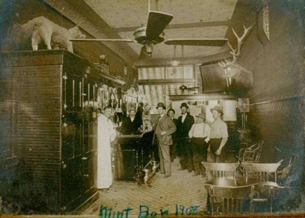
    <summary type="html"><![CDATA[<p><strong><em>In 1907 Charles “Dick” Marlow founded the Mint Saloon in Sheridan, WY. When Wyoming Prohibition laws banned alcohol in 1919, Marlow rebranded “the Mint” as legal storefronts but continued illegal alcohol sales. In 1935, post-Prohibition, the Mint Bar reopened its storefront as a bar. Today, the Mint Bar is still a staple of entertainment in Sheridan, Wyoming.</em></strong></p><img src="https://www.intermountainhistories.org/files/fullsize/634d0740f89c76472de8ecde2b526e01.jpg" alt="The Mint Bar in 1907, shortly after opening. " /><br/><p>In 1907 Charles “Dick” Marlow bought the building that would later become the Mint Bar from a barber and transformed it into the “Mint Saloon,” which locals often referred to as “the Mint.” In 1919, Wyoming passed laws banning the sale and consumption of alcohol unless for prescribed medicinal purposes. At this time, Marlow changed the Mint’s front into a dress shop, then a real estate office, while continuing alcohol sales in the back. In 1923, Oran Moore purchased the Mint, turning it into the “Mint Cigar Company and Soda Shop.” Between 1923 and 1930, Moore operated the Mint’s legal front while maintaining one of Sheridan’s more notorious speakeasies and gambling halls in the back.
During this time, law enforcement suspected the Mint of alcohol sales and conducted multiple raids on the location. On 23 June 1925, the <em>Sheridan Post Enterprise</em> published an article describing a moonshine bust at the Mint. Sheridan town sheriffs and a Wyoming state officer raided the Mint at four o’clock in the afternoon. Police discovered one gallon of moonshine whiskey hidden in a coffee pot by employees. The officers arrested Moore and several other employees. The court fined Moore $500.
On Tuesday, 23 June 1925, an article appeared in the <em>Sheridan Post Enterprise</em> about the officer’s raid at the Mint. A month later, the paper published a follow-up article on Tuesday, 07 July 1925, which mentioned that the court judge postponed the Mint employees’ trial. Lax police and judicial enforcement meant that raids, arrests, and trials like this never prevented the Mint from selling illegal alcohol. The establishment continued its bootlegging and alcohol sales until the stock market crash of 1929 forced Moore to close its doors. In 1933, the United States’ Twenty-first Amendment ended Prohibition, and Wyoming dissolved its alcohol ban.
In 1934, Archie Milson and Robert Thirlwell purchased the establishment and reopened the space as “the Mint Bar.” In 1948, the owner at the time, Lauren L. McVean, renovated the Mint Bar, giving the location its warm rustic style and now iconic bucking horse and cowboy neon sign. Cowboys, locals, travelers, and even celebrities like Ernest Hemingway once again made the bar a popular stop because of its historic charm, great beer, and gambling.
The Mint Bar’s story shows how Prohibition reshaped Sheridan without breaking its spirit. The hidden bar was a gathering place for cowboys and townsfolk alike. Raids and fines were a constant threat, but the establishment’s patrons remained loyal. After Prohibition, the Mint Bar never lost its notoriety. Today, “Meet me at the Mint” is now a signature phrase shared between Sheridan locals. The Mint Bar’s history is a nod to Western independence and resilience.</p><p><em><strong><a href="https://www.intermountainhistories.org/items/show/894">For more (including 4 images) view the original article</a></strong></em></p>]]></summary>
    <published>2025-09-23T15:34:46+00:00</published>
    <updated>2026-04-17T19:32:20+00:00</updated>
    <link rel="alternate" type="text/html" href="https://www.intermountainhistories.org/items/show/894"/>
    <id>https://www.intermountainhistories.org/items/show/894</id>
    <author>
      <name>Scarlett Kluge, Northern Arizona University </name>
    </author>
  </entry>
  <entry>
    <title type="html"><![CDATA[Sheep Eaters (Mountain Shoshones) in the Greater Yellowstone Ecosystem]]></title>
    <summary type="html"><![CDATA[<p><strong><em>The Sheep Eaters (also known as Mountain Shoshones, Tukudika, or Snake Indians), resided in Yellowstone National Park, the Wind River Mountains in Wyoming, and parts of central Idaho, until the reservation era.</p></strong></p><img src="https://www.intermountainhistories.org/files/fullsize/5a9a77ddc55c952bffe2d127a3c16817.jpg" alt="Tukudika (Sheepeater) men, women, and children at Medicine Lodge Creek, Idaho, in 1871." /><br/><p><span style="font-weight:400;">Much of the history of the Sheep Eaters emanates from archeological and ethnographic research. Many scholars believe their origins are in the Great Basin, though that continues to be debated. Trappers like Osborne Russell were among the first Euro-Americans to leave written accounts about the Sheep Eaters. Russell noted that a group of about 22 Sheep Eaters he met were “neatly clothed in dressed deer and Sheep skins of the best quality and seemed to be perfectly contented and happy … [They had] about 30 dogs on which they carried their skins, clothing, provisions etc on their hunting excursions. They were well armed with bows and arrows pointed with obsidian…” Early descriptions provide useful information, but they also often encouraged stereotypes. For example, Philetus Norris, Superintendent of Yellowstone National Park in 1877, described the Sheep Eaters as “vanished” and “hermits."</span>
<span style="font-weight:400;">The Sheep Eaters domesticated dogs they used to carry packs and pull travois. Their name came from their main source of food, Rocky Mountain Bighorn Sheep, which the dogs may have assisted in hunting. Pots and pipes carved from steatite represent another distinguishing characteristic of Sheep Eater culture.</span>
<span style="font-weight:400;">The Sheep Eaters participated in the Rocky Mountain fur trade from the 1820s through the 1850s. During the 1870s, the Lemhi Valley Agency was created to oversee the removal of the Sheep Eaters, Bannocks, and Shoshones to Lemhi Valley in central Idaho. In 1880, they began to be relocated to Fort Hall, but some Sheep Eaters remained in Yellowstone, eventually joining the Eastern Shoshones on the Wind River Reservation. Idaho censuses continued to list Sheep Eaters as a distinct group through the early part of the twentieth century.</span>
<span style="font-weight:400;">It is important to note that the Sheep Eaters did not “vanish” or go extinct as Norris and others described. </span><span style="font-weight:400;">Today, some of the Sheep Eater descendants live on the Wind River Reservation in Wyoming and the Fort Hall Reservation in Idaho. </span>
<span style="font-weight:400;">In 2023, the town of Jackson, Wyoming issued a land acknowledgement concerning the Sheep Eaters:</span>
<ul>
<li><em><span style="font-weight:400;">We recognize that the land we are gathering on is the ancestral homeland of the Mountain Shoshone People who stewarded it for thousands of years and that many other tribes also lived upon and cared for this area … With gratitude, we honor Indigenous peoples, past and present. We also acknowledge the sovereignty of the Native nations closest to Jackson whose land was taken through broken treaties that resulted in the creation of the Wind River and Fort Hall Indian Reservations. We recognize this acknowledgement is simply a first step. The Town of Jackson is committed to continued and informed action to connect with Indigenous people.</span></em></li>
</ul></p><p><em><strong><a href="https://www.intermountainhistories.org/items/show/887">For more (including 3 images) view the original article</a></strong></em></p>]]></summary>
    <published>2025-04-19T02:12:32+00:00</published>
    <updated>2026-04-17T19:32:20+00:00</updated>
    <link rel="alternate" type="text/html" href="https://www.intermountainhistories.org/items/show/887"/>
    <id>https://www.intermountainhistories.org/items/show/887</id>
    <author>
      <name>Emmaretta Barnett, Brigham Young University</name>
    </author>
  </entry>
  <entry>
    <title type="html"><![CDATA[Hastings Cutoff: A Not-So-Short Cut]]></title>
    <summary type="html"><![CDATA[<p><strong><em><span style="font-weight:400;">Made famous by the disaster of the Donner-Reed Party in 1846, Hastings Cutoff saved travelers a few hundred miles on the trek to Oregon or California. The trail started at Fort Bridger in present-day Wyoming and traversed the Wasatch Mountains before reaching the Salt Flats. However, it proved to be very unsuitable – even disastrous – for wagon travel.</span></em></strong></p><img src="https://www.intermountainhistories.org/files/fullsize/49e805c728cb5ee3cd9c072ba1c37956.jpg" alt="Fort Bridger, established in 1843. " /><br/><p><span style="font-weight:400;">Despite its name, the western explorer John C. Frémont was the first to traverse the trail that came to be known as Hastings Cutoff. The route was named after Lansford Warren Hastings in the following summer of 1846 when Hastings made it famous in his </span><i><span style="font-weight:400;">Emigrants’ Guide to Oregon and California</span></i><span style="font-weight:400;">, encouraging those headed westward to take it and save three hundred miles. He also promised that he would meet emigrants at Fort Bridger and guide them the rest of the way. That promise further convinced the Donner brothers and James Reed of the wisdom of taking the cutoff, though several in the party decided to stick with the proven trail.</span>
<span style="font-weight:400;">Unfortunately, Hastings had already left Fort Bridger to guide emigrants already on the trail by the time the Donner-Reed Party arrived at the fort. He promised to leave letters with directions for them. Edwin Bryant, a fellow expeditioner, advised in a letter to Reed that the plans to take the cutoff be abandoned. There was a forty-mile stretch devoid of water and the trail was simply not fit for wagons. Jim Bridger and Louis Vasquez withheld Bryant’s letter, however, since they had a financial interest in seeing Hastings Cutoff traveled. Partly because they did not receive that letter, the Donner-Reed Party pressed on. </span>
<span style="font-weight:400;">Almost nothing that the Donner-Reed Party understood about the cutoff was accurate, from the easiness of the way to the length of the trail and the available supplies of water and provisions. In her diary, Virginia Reed Murphy recorded that “at times it was hard to find any trace of the cutoff.” </span>
<span style="font-weight:400;">Hastings left extremely vague directions along the way and refused to guide the Donner-Reed Party when Reed, C. T. Stanton, and William Pike went and asked for his help. It was too dangerous to continue through Weber Canyon, so they took their chances in uncharted territory, where there were no roads or clear paths through the trees and underbrush. Virginia noted that “It took the men six days to clear a trail only thirteen miles in length.” They finally got through the Wasatch Mountains and by the time they reached the Great Salt Lake, the cutoff had taken a month (as opposed to the promised week) “and our cattle were so exhausted that they were not fit to cross the desert.” </span>
<span style="font-weight:400;">It truly is no wonder that once Virginia was settled in California, she wrote the following to friends back in the East who were planning to travel West: “Bring nothing but provisions and just enough clothing to last until you get here…and don’t take any cutoffs.” </span>
<span style="font-weight:400;">Much of the scholarship about Hastings Cutoff is about Hastings himself, if he were just as much a victim of the hard trail as the others or a scheming charlatan. Most people choose to believe the latter, especially as he received several death threats for his advice.</span></p><p><em><strong><a href="https://www.intermountainhistories.org/items/show/880">For more (including 4 images) view the original article</a></strong></em></p>]]></summary>
    <published>2025-01-27T04:23:30+00:00</published>
    <updated>2026-04-17T19:32:20+00:00</updated>
    <link rel="alternate" type="text/html" href="https://www.intermountainhistories.org/items/show/880"/>
    <id>https://www.intermountainhistories.org/items/show/880</id>
    <author>
      <name>Danielle Morgan, Brigham Young University</name>
    </author>
  </entry>
  <entry>
    <title type="html"><![CDATA[The Lonetree Mercantile and Post Office]]></title>
    <summary type="html"><![CDATA[<p><strong><em><span style="font-weight:400;">In the center of a ranching town called Lonetree, there is an old building with a white façade and log construction that once functioned as the Post Office and mercantile store for the remote community. From 1897 to 1982, the store served as the nerve center for the community.</span></em></strong></p><img src="https://www.intermountainhistories.org/files/fullsize/de8a2ff11079a55bb74a187bf6522441.jpg" alt="Ranchers pose in front of the Lonetree Mercantile. " /><br/><p><span style="font-weight:400;">Lonetree, Wyoming, is situated just north of the high Uinta Mountains and twenty miles south of Fort Bridger. Henrys Fork River, a tributary of the Green River, first brought fur-trading Europeans to the area. Those who stayed were the descendants of LDS pioneer Captain Isaac Bullock. Bullock was sent to the area by Brigham Young in the early 1850s.</span><span style="font-weight:400;"> The Bullocks were joined by many other families. These homesteaders eventually turned to ranching. </span>
<span style="font-weight:400;">In 1897, an immigrant from Manchester, England, named Herbert Joshua Gregory came to Lonetree. Since the old post office run by R. Handley had burned down, Gregory built his own.</span><span style="font-weight:400;"> Gregory’s store provided necessary supplies and correspondence to the ranchers and townspeople in the area. A visitor to the store could expect news of deaths, births, stolen livestock, grazing permits, events, and even outlaws.</span><span style="font-weight:400;"> Dances, turkey hunts, games, and gatherings of all kinds took place around the Gregory store.</span><span style="font-weight:400;"> It is said that Butch Cassidy and the Sundance Kid were among the outlaws who stopped by Gregory’s store and interacted with members of the community.</span><span style="font-weight:400;"> Gregory was the postmaster until his death in 1952, and the title of postmaster would remain in his family until 1982 when the post office closed.</p><span style="font-weight:400;">Thanksgiving in Lonetree, 1890, made for a popular story. It is said that a Pinkerton agent came to the Gregory store and formed a posse to catch two outlaws who were riding towards Lonetree. One of the outlaws was Harry Alonzo Longabaugh or the Sundance Kid. H. J. Gregory, the town fiddler, and several others rode out to apprehend them. With no fiddler, the Thanksgiving dance could not begin. While people milled around the schoolhouse, Harry Longabaugh and his partner walked into the Gregory store. The story says that the townspeople captured Longabaugh and made him play the fiddle for their dance where he stayed long enough to dance with a woman and escape before the return of the Pinkerton agent.</span><span style="font-weight:400;"> </span>
<span style="font-weight:400;">Lonetree remains a ranching community with a small population that has not forgotten its origins in the Wild West.</span></p><p><em><strong><a href="https://www.intermountainhistories.org/items/show/875">For more (including 4 images) view the original article</a></strong></em></p>]]></summary>
    <published>2025-01-23T00:33:27+00:00</published>
    <updated>2026-04-17T19:32:20+00:00</updated>
    <link rel="alternate" type="text/html" href="https://www.intermountainhistories.org/items/show/875"/>
    <id>https://www.intermountainhistories.org/items/show/875</id>
    <author>
      <name>Landon Wilson, Brigham Young University</name>
    </author>
  </entry>
  <entry>
    <title type="html"><![CDATA[The Johnson County Cattle War]]></title>
    <summary type="html"><![CDATA[<p><strong><em><span style="font-weight:400;">After assembling an armed expedition of wealthy cattlemen and hired Texas gunmen, members of the Wyoming Stock Growers Association rode on horseback to the small ranch of their first suspected cattle rustling target, Nate Champion. After gunning both Champion and his brother Nick Ray down at the K.C. Ranch, the Invaders continued North where they became involved in yet another hours-long standoff with a posse consisting of around two hundred Johnson County residents who had been warned of the invasion.</span></em></strong></p><img src="https://www.intermountainhistories.org/files/fullsize/2b084641e34d158b100ac1b672c9b922.jpg" alt="The T.A. Ranch barn where the invaders took cover from the gunfire of the Johnson County posse for hours before being taken into custody by the U.S. Army." /><br/><p><span style="font-weight:400;">Following the organization of an armed expedition by the Wyoming Stock Growers Association, the “Invaders” rode for 68 miles to K.C., the home of small-time rancher Nate Champion. Reaching the ranch, the Invaders planned to capture Champion and get a confession of rustling out of him before hanging him. It wasn’t until after the cabin was surrounded that the Invaders discovered that two trappers and Champion’s brother Nick Ray were also at the cabin. Taking the two trappers captive, the Invaders shot down Ray when he stepped out of the cabin. </span>
<span style="font-weight:400;">While the shooting between Champion and the Invaders continued from noon to 3 o’clock, two people passing by witnessed the shootout and fled while being fired upon by some of the Invaders. In their escape, the people left their hay-filled wagon behind which the Invaders then used to burn down the cabin with Champion inside. Knowing his flaming fate was at hand, Champion chose his own way out and ran out of the cabin with a rifle in one hand and revolver in the other, firing on the Invaders as he was shot down beside the burning cabin. After disposing of Champion’s body, the Invaders found that their plan for assassinating the officials of Johnson County was spoiled by people alerting Sheriff Red Angus of Buffalo. Hearing that armed Johnson County citizens were attempting to head them off, the Invaders decided to reach the T.A. Ranch where they fortified against the posse.</span>
<span style="font-weight:400;">After reaching the T.A. Ranch, the Invaders took apart many of the wagons they brought with them and reinforced the barn and other structures to protect them against gunfire. As Sherriff Red Angus organized his deputies to confront the Invaders, he deputized any able-bodied men who they came across on their way to the T.A. ranch. With his posse now totaling over 200 men, Angus surrounded the T.A. ranch and the two sides hunkered down for a two day standoff with near constant gunfire from both sides.</span>
<span style="font-weight:400;">During those two days the posse built a mobile bunker to approach the Invader’s defenses and burn them down while being protected from gunfire. While the posse was constructing the “go-devil” from the Invader’s salvaged wagons, allies of the Invaders in Cheyenne alerted the acting governor of Wyoming Amos Barber of their besiegement by the residents of Johnson County. Governor Barber, being associated with the WSGA, immediately telegraphed a request for the federal troops stationed near Buffalo in Fort McKinney to put a peaceful end to the insurrection and put the Invaders safely into their custody. When the troops arrived, the shootout ended with no fatalities. The Invaders were apprehended by federal troops and returned to Cheyenne, where they faced a series of inconclusive trials.</span></p><p><em><strong><a href="https://www.intermountainhistories.org/items/show/868">For more (including 3 images) view the original article</a></strong></em></p>]]></summary>
    <published>2024-10-21T20:57:49+00:00</published>
    <updated>2026-04-17T19:32:19+00:00</updated>
    <link rel="alternate" type="text/html" href="https://www.intermountainhistories.org/items/show/868"/>
    <id>https://www.intermountainhistories.org/items/show/868</id>
    <author>
      <name>Cooper Smith, Rocky Mountain College</name>
    </author>
  </entry>
  <entry>
    <title type="html"><![CDATA[Outside Invaders and the Johnson County Cattle War]]></title>
    <summary type="html"><![CDATA[<p><strong><em><span style="font-weight:400;">With violence and vigilantism on the rise in the late 1800s cattle industry, Wyoming had been booming with the success of both large thousand-head outfits and smaller family or individual-owned outfits. Within years the competition for both grazing land and the heads of cattle sparked cattle rustling and vigilante violence from both kinds of operators. To end this, the wealthy Stockgrowers made a hit list of rustlers and associates in Johnson County and hired over twenty Texas gunmen to kill or coerce the people of Johnson County.</span></em></strong></p><img src="https://www.intermountainhistories.org/files/fullsize/99d595cea52803cc73bd2e751eb8dd24.jpg" alt="Invaders on horseback in Casper before departing to the K.C. Ranch in Johnson County." /><br/><p><span style="font-weight:400;">In 1892, after years of economic and political competition between smaller ranches and the larger mostly foreign-owned cattle companies, a series of vigilante lynchings took place across Wyoming, particularly in the Northeastern portion of the state where Johnson County is located. The Wyoming Stock Growers Association (WSGA), representing the large cattle companies, accused many smaller cattle operations of stock theft, but local juries refused to convict because of lack of evidence or sympathy for the smaller operators. With seemingly no quick legal action able to stop any alleged rustlers, the WSGA devised a plan for an expedition to northeastern Wyoming to capture, coerce, or kill the rustlers and their associates.</span>
<span style="font-weight:400;">The network of stock growers and their associates was deeply entrenched in both state politics and economics. Judges, politicians, and bankers worked with ranchers to plan this expedition into rustler territory to root out the suspected rustlers. The scale of the operation was astonishing with the amount of sourcing of supplies, transportation, weapons & ammunition, and number of men involved. The crew of the expedition to Johnson County included multiple WSGA members, stock inspectors, and around twenty gunslingers brought by train from Texas. Using Cheyenne as their base of operations and calling themselves the Invaders, this 50-man group confidently had their photograph taken before at Fort D.A. Russell in Cheyenne before they left for Johnson County.</span>
<span style="font-weight:400;">Meanwhile in Cheyenne, the inner circles of the stock growers worked to establish their legal justifications for their violent actions against the suspected rustlers and their associates. Dozens of the expedition members, including the Texas gunmen, partied throughout both the day and night at many of the wealthier association members’ estates. When the Invaders regrouped in the morning, they boarded a privately booked train to Casper further north. While riding the train, some stops included a photo shoot of the train passing through Platte Canyon on its way to Casper. The expedition rode onward to the K.C. Ranch where they planned to kill one of their primary rustler targets, Nate Champion. Once again taking the opportunity to document their actions, the Invaders had the mounted expedition photographed before leaving to kill Nate Champion and move on to the town of Buffalo.</span></p><p><em><strong><a href="https://www.intermountainhistories.org/items/show/867">For more (including 3 images) view the original article</a></strong></em></p>]]></summary>
    <published>2024-10-21T18:53:43+00:00</published>
    <updated>2026-04-17T19:32:19+00:00</updated>
    <link rel="alternate" type="text/html" href="https://www.intermountainhistories.org/items/show/867"/>
    <id>https://www.intermountainhistories.org/items/show/867</id>
    <author>
      <name>Cooper Smith, Rocky Mountain College</name>
    </author>
  </entry>
  <entry>
    <title type="html"><![CDATA[Keyhole Beach: The Key to Beach Life]]></title>
    <summary type="html"><![CDATA[<p><strong><em>The "key" to beach life in Wyoming can be found at Keyhole Beach. The land originally belonged to the Sioux, however, the U.S. government claimed it in 1877 and the beach was later created by the reservoir behind Keyhole Dam in 1952.</em></strong></p><img src="https://www.intermountainhistories.org/files/fullsize/a1198626791a7dda71da4448f593c7fd.jpg" alt="Keyhole Reservoir, 2008" /><br/><p>Located on the southeast shore of Keyhole Reservoir, Keyhole Beach is hailed for its fishing opportunities and as a “mecca” for bird-watching with about 225 species to see. Along with catching one of Wyoming’s largest fish, a freshwater drum, beachgoers can enjoy swimming, boating, kayaking, paddleboarding, sunbathing, and waterskiing. The closest campground is called Tatanka, after the Lakota word for “buffalo.” Tatanka Campground has the best selection of amenities in the area, including water and electric hookups for RVs and rentable cabins, as well as picnic tables at Tatanka, a marina, and a boat launch on the beach. </p><p>The Sioux inhabited and controlled the area long before the Bureau of Reclamation completed Keyhole Dam in 1952, and they continue to fight for this right today. In the Ft. Laramie Treaty of 1868, the U.S. recognized the tribe's ownership of the Black Hills territory which included the Šahíyela Wakpá River (also known as the Belle Fourche River). Named by French fur traders in the 1780s, Bella Fourche means “beautiful fork.” As miners illegally entered the territory throughout the 1870s, the settlers and the Sioux continued to have disputes about the ownership of the territory, and after the defeat of Custer at Little Bighorn, the U.S. waged war on the Sioux and then confiscated their land in 1877. While offered monetary compensation for the land grab after the 1980 Supreme Court case United States v. Sioux Nation of Indians, the Sioux believed this was an insufficient settlement and declined the money. The dispute over land ownership, and the Sioux’s claim on it, continues today. </p><p>As the gold rush persisted in the Black Hills more settlers moved in and in 1891 the Chicago and Northwestern Railroad entered the town of Belle Fourche, seventy-three miles to the northeast. The community became a livestock shipping hub and the name of Keyhole Reservoir derives from the livestock brand the McKean brothers used at their nearby ranch. The Bureau of Reclamation proposed the dam as a part of the Belle Fourche Project, started in 1904, which irrigated lands in the area. While ranchers protested the dam in 1950 due to their loss of farming land, the benefits of wildlife conservation, flood control, and recreational opportunities outweighed their concerns. </p><p>With the completion of the dam in 1952, beach life started to take off at Keyhole Reservoir with the creation of Keyhole State Park. In 1984, the Keyhole Expo was a county fair on the beach's shores that included hot air balloon racing, windsurfing, and more. In 1989, the State Park expanded upon the fair as a part of Wyoming State Park’s “Summerfest.” This event included boat rides to discover the beauty of Keyhole Reservoir, arts and crafts booths, and food concessions. </p><p>Today, Keyhole Beach hosts events such as a Lantern Fest where beachgoers can release floating lanterns on the reservoir and witness the illumination of the lake. Keyhole Marina also contains a bar and grill where visitors can eat and listen to live music on the beach. The community-oriented marina and campgrounds paired with scenic views make Keyhole Beach a memorable vacation spot.</p><p><em><strong><a href="https://www.intermountainhistories.org/items/show/845">For more (including 3 images) view the original article</a></strong></em></p>]]></summary>
    <published>2024-09-03T19:39:03+00:00</published>
    <updated>2026-04-17T19:32:19+00:00</updated>
    <link rel="alternate" type="text/html" href="https://www.intermountainhistories.org/items/show/845"/>
    <id>https://www.intermountainhistories.org/items/show/845</id>
    <author>
      <name>Olivia Hall, Northern Arizona University</name>
    </author>
  </entry>
  <entry>
    <title type="html"><![CDATA[Old Faithful Inn - Yellowstone National Park]]></title>
    <summary type="html"><![CDATA[<p><strong><em><span style="font-weight:400;">When the Northern Pacific Railroad’s Upper Geyser Basin Hotel burned to the ground on November 17, 1894, the U.S government pressured the railroad to replace it with new tourist accommodations. The result was Old Faithful Inn, which utilized a new style of architecture to highlight Yellowstone’s iconic landscape. </span></em></strong></p><img src="https://www.intermountainhistories.org/files/fullsize/eddddd6f4d185123b8615299ae39a69b.jpg" alt="Old Faithful Inn, Entrance Drive" /><br/><p><span style="font-weight:400;">On March 1, 1872, President Ulysses S. Grant officially signed Yellowstone into law as America’s first national park. The Yosemite Act of 1864 had restricted settlement in the Yosemite Valley and placed it under the jurisdiction of California’s state government, but the Yellowstone Park Act expanded upon this legislation by designating all of Yellowstone a public park. As a result, the Yellowstone Park Act contained many restrictions on private development and very few administrative procedures to enforce regulations or oversee public use. Poorly supervised independent companies called concessionaires, who paid park administrators a fee to use the land, ran Yellowstone’s public facilities. Only a few concessionaires ferried guests into the park, but the Northern Pacific Railroad quickly expressed interest in Yellowstone’s small tourism industry.</span>
<span style="font-weight:400;">When the Northern Pacific reached Gardiner, Montana, in the early 1880s, its presence provoked interest in Yellowstone’s tourism industry. At this time, only a few concessionaires opened small hotels and tent camps. One such concessionaire, the Yellowstone Park Improvement Company, constructed the Upper Geyser Basin Hotel in 1885 to preserve its failing business. The Northern Pacific purchased its properties in 1885, gaining control of the Upper Geyser Basin Hotel. When fire destroyed it</span><span style="font-weight:400;"> in 1894,</span><span style="font-weight:400;"> the importance of a new hotel in Yellowstone became clear</span><span style="font-weight:400;">. At the time</span><span style="font-weight:400;">, many railroad hotels utilized conventional architectural styles that provided a sense of familiarity for their upper-class audience. The Northern Pacific’s Lake Hotel, constructed in 1890, followed this example. However, </span><span style="font-weight:400;">rustic architecture, which emphasized harmony with the natural environment surrounding a structure, gained popularity in the 1890s. Because distinctive architecture drew more attention from visitors, the Northern Pacific experimented with a rustic style for its new hotel. </span>
<span style="font-weight:400;">The Yellowstone Park Association, a subsidiary of the Northern Pacific, selected Robert Reamer to design its new rustic hotel. The railroad constructed the log building near Yellowstone’s most famous geyser, from which the Old Faithful Inn derived its name. </span><span style="font-weight:400;">The Union Pacific completed the central core of the hotel, known as the “Old House,” in 1903.</span><span style="font-weight:400;"> The finished building was seven stories tall at its highest point, and it cost a total of $140,000 (about $4.9 million today) to construct. The Northern Pacific set aside a further $25,000 (approximately $875,000 today) to furnish the new hotel. Reamer designed his massive log structure to emulate Swiss chalets and Norwegian villas, and he utilized rough, unfinished wood logs obtained in the Park on both the inside and outside of the building to connect it to Yellowstone’s forested landscape. The hotel’s most prominent feature is its seven-story lobby, which features a vast fireplace made of native stone. A complex log frame that supports the hotel’s roof surrounds this room. The structure’s use of exposed wooden supports emphasizes the rustic nature of the lobby, and a series of wooden balconies overlook the main floor of the hotel. </span></p><p><em><strong><a href="https://www.intermountainhistories.org/items/show/839">For more (including 5 images) view the original article</a></strong></em></p>]]></summary>
    <published>2024-05-29T19:43:03+00:00</published>
    <updated>2026-04-17T19:32:19+00:00</updated>
    <link rel="alternate" type="text/html" href="https://www.intermountainhistories.org/items/show/839"/>
    <id>https://www.intermountainhistories.org/items/show/839</id>
    <author>
      <name>Kaylen Wilson, Northern Arizona University</name>
    </author>
  </entry>
  <entry>
    <title type="html"><![CDATA[Rocky Mountain Herbarium]]></title>
    <summary type="html"><![CDATA[<p><strong><em>Aven Nelson was originally an English professor but was unexpectedly thrust into the world of botany after being hired at the University of Wyoming in 1893. He discovered a passion for the subject, eventually leading to the creation of the Rocky Mountain Herbarium. Over the years, the herbarium has assembled a collection of 1.3 million specimens through extensive collection efforts and collaborations.</em></strong></p><img src="https://www.intermountainhistories.org/files/fullsize/a9b0acfa38d3d30d1c75600955782178.jpg" alt="Rocky Mountain Herbarium collection sites" /><br/><p><span style="font-weight:400;">The Rocky Mountain Herbarium is at the University of Wyoming in Laramie, Wyoming. Aven Nelson, one of the original faculty members,  established the herbarium in 1893. The university initially hired Nelson as an English professor, but the board of directors made him the biology professor when the school mistakenly employed two English professors. This position led to Nelson discovering his passion for botany. His interest in botany grew as he assisted the university's resident plant expert, Burt Buffum, in identifying plant samples for the Chicago World's Fair in 1893. Nelson's journey in botany continued with his exploration into the Yellowstone National Park in 1899. His journey gained him respect within the botany field, leading to the official establishment of the herbarium as part of the University of Wyoming, with Nelson as its curator. He named it </span><i><span style="font-weight:400;">The Rocky Mountain Herbarium.</span></i><span style="font-weight:400;"> Nelson later became the president of the American Society of Plant Taxonomists and Botanical Society of America and the president of the University of Wyoming from 1918 to 1922.</span></p><p><span style="font-weight:400;">       Following Nelson's resignation in 1930, the herbarium experienced additional growth with the installation of the W. G. Solheim Mycological Herbarium. Added to the herbarium by the head of the university botany department, Dr. Wilhelm G. Solheim, it was Solheim's personal collection of fungi. With 48,000 fungi specimens, it is the largest collection of fungi globally. In 1960, the herbarium collection, comprising around 265,000 samples, moved to the Aven Nelson Memorial Building. Initially constructed as the university's first library in 1923, the building provided a new home for the expanding herbarium. The herbarium collection further grew in 1982 when the US Forest Service National Herbarium (USFS), founded in Washington, D.C., granted an indefinite loan of 120,000 plant specimens. Between the Rocky Mountain Herbarium's personal collection, W. G. Solheim Mycological Herbarium, and the collaboration with the USFS, the herbarium archives now contain over 1.3 million plant samples. This collection has earned the reputation of being one of the largest herbariums between St. Louis and the West Coast.</span></p><p><em><strong><a href="https://www.intermountainhistories.org/items/show/821">For more (including 4 images) view the original article</a></strong></em></p>]]></summary>
    <published>2024-05-21T21:49:59+00:00</published>
    <updated>2026-04-17T19:32:18+00:00</updated>
    <link rel="alternate" type="text/html" href="https://www.intermountainhistories.org/items/show/821"/>
    <id>https://www.intermountainhistories.org/items/show/821</id>
    <author>
      <name>Cristal A. DeSantiago, Northern Arizona University</name>
    </author>
  </entry>
  <entry>
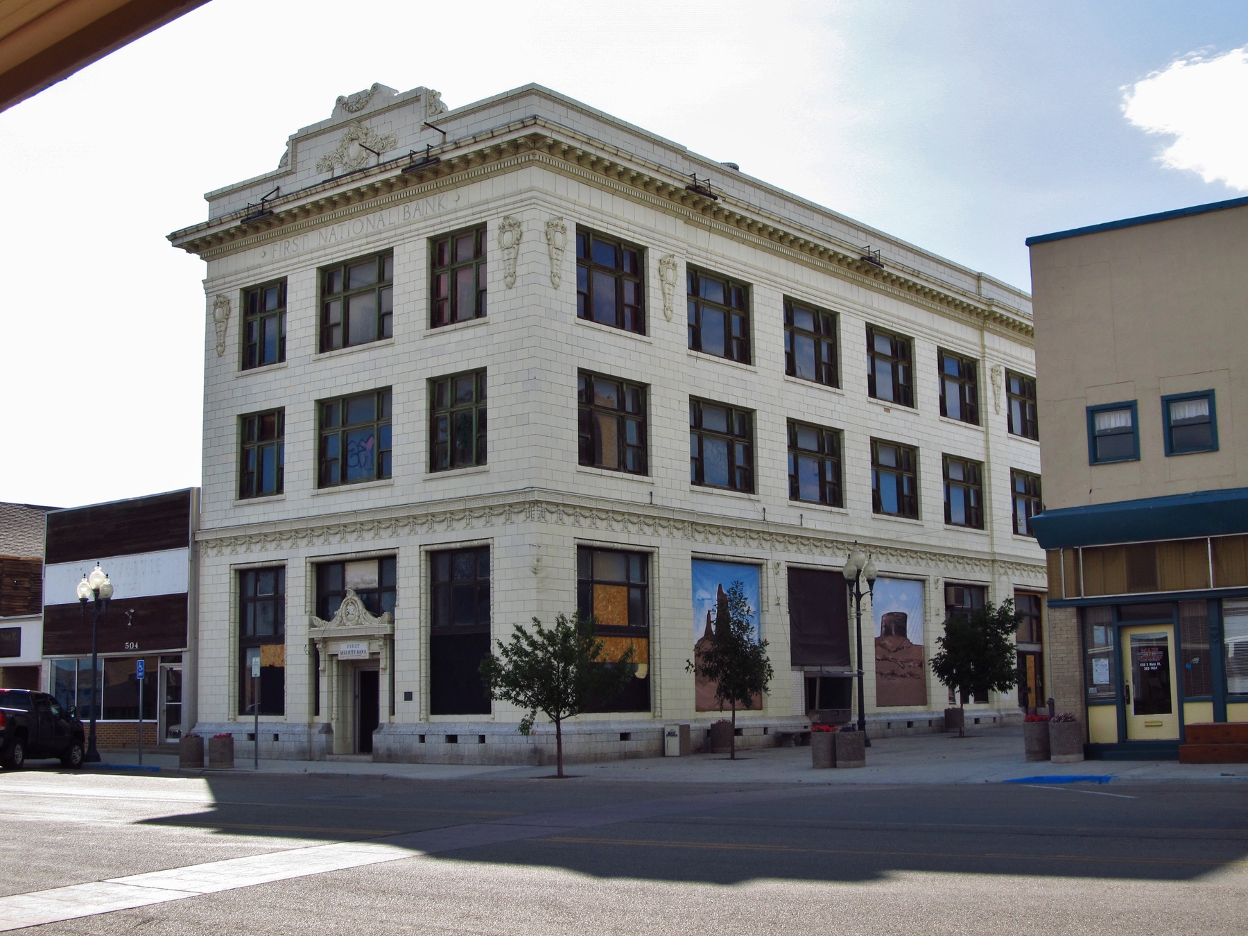
    <title type="html"><![CDATA[First National Bank of Rock Springs]]></title>
    <summary type="html"><![CDATA[<p><strong><em>Founded in 1887 as a local institution, the First National Bank of Rock Springs became one of Wyoming’s most stable financial houses, operating for 110 years.</em></strong></p><img src="https://www.intermountainhistories.org/files/fullsize/d43c0253826109ad76e45834b493d866.jpg" alt="The First National Bank" /><br/><p><span style="font-weight:400;">In the late 1880s, Rock Springs began transitioning from a modest mining town into western Wyoming’s economic center, and the state’s financial interests took notice. First among them was Henry Gordon Balch, a stockman and state politician who established the Laramie National Bank in 1881. In response to Rock Springs’s mounting population, growing by 346% from 1880-90, Balch expanded his reach, opening the First National Bank of Rock Springs in 1887.</span>
<span style="font-weight:400;">By 1890, Balch’s speculation paid off, as First National’s assets reached $270,000, with almost $20,000 in gold and silver on hand. This success allowed Balch to expand further by founding the Rock Springs Coal Company and the Commercial National Bank in Salt Lake City, bolstering First National’s profile. As ranching and mining operations developed, the bank’s wealth jumped to $389,000 by 1900, only for Balch to pass away from pneumonia in 1901, aged forty-nine. </span>
<span style="font-weight:400;">In Balch’s wake, Augustine Kendall, a long-term financial partner who co-established First National as its cashier, became president. Kendall, who held interests in lumber, cattle, and sheep, also served as Rock Spring’s Mayor from 1904-07. He also increased First National’s standing through his personal reputation and supplementary holdings. By 1909, assets reached $750,000, becoming Wyoming’s third-largest financial house. Kendall also served as Wyoming’s Federal Fuel Administrator from 1917-20, a department encouraging energy conservation by supporting American entry into the Great War.</span>
<span style="font-weight:400;">By 1917, First National’s directors hired Walter J. Cooper, a Salt Lake City-based architect, to construct a more secure building for their financial operations. Compared to the older structure, built from stone and prone to collapse after a fire, the new bank consisted of fire-resistant materials like brick and cement. The bank, now three stories high, became Rock Springs’s tallest structure, centrally located across from the local railroad situation. By 1922, First National's assets rested at $1.2 million. Kendall served as bank president until 1927, eventually retiring in California and dying in 1944, aged 81.</span>
<span style="font-weight:400;">By 1928, First National, acquired by Eccles-Browning Affiliated Banks, an Intermountain financial conglomerate including sixteen other operations, became the First Security Bank of Rock Springs. Marriner Eccles, becoming a millionaire at age twenty-one, served as the corporation’s leading figure, and later became a member of the Federal Reserve Board from 1934-51, acting as its chairman until 1948. Eccles further consolidated Intermountain finance in 1929 by establishing the First Security Cooperation of Ogden after purchasing another eight banks, making twenty-five total. Altogether, these financial houses encompassed $46 million in assets, with First Security representing $2 million, or 4.3%, of the conglomerate’s value.</span>
<span style="font-weight:400;">Corporate ownership of First Security continued, and its profitability grew. By 1975, $19.7 million existed in client accounts, increasing to $40.7 million in 1982 and $71.3 million in 1993. However, by 1997, First Security Corporation merged its Rock Springs branch, previously semi-independent, into its corporate structure. In 2000, First Security Corporation, bought out by Wells Fargo & Company, shuttered operations completely. The bank building, empty and in disrepair for many years, is currently under renovation.</span></p><p><em><strong><a href="https://www.intermountainhistories.org/items/show/797">For more (including 6 images) view the original article</a></strong></em></p>]]></summary>
    <published>2024-03-20T23:36:48+00:00</published>
    <updated>2026-04-17T19:32:17+00:00</updated>
    <link rel="alternate" type="text/html" href="https://www.intermountainhistories.org/items/show/797"/>
    <id>https://www.intermountainhistories.org/items/show/797</id>
    <author>
      <name>William R. Batson, Northern Arizona University</name>
    </author>
  </entry>
  <entry>
    <title type="html"><![CDATA[John Jarvie’s Historic Ranch]]></title>
    <summary type="html"><![CDATA[<p><strong><em>Not all hospitality is returned in kind. In the case of John Jarvie, the outlaws to whom he was so obliging went on to rob and murder both him and his son. </p></strong></p><img src="https://www.intermountainhistories.org/files/fullsize/fa571c3f7ee8336879f9a9d505c7f737.jpg" alt="John Jarvie" /><br/><p><span style="font-weight:400;">In 1880 John Jarvie and his wife Nellie Barr moved from Rock Springs, Wyoming to the burgeoning settlement of Brown’s Park. Jarvie set up a general store, post office, and ran a river ferry that crossed the nearby Green River. Jarvie became well known for his sagacity and kindness to all those who lived in the region, even the Wild Bunch outlaws. Such associations did not serve him well in the long run, but his kindness did, and his legacy has continued to today in Uintah and Daggett County.</span>
<span style="font-weight:400;">John Jarvie was born in Scotland in 1844. As a young man after being beaten soundly by a mine supervisor, Jarvie elected to immigrate to the United States as a stowaway. He arrived in America in 1870 and settled in Rock Springs, Wyoming.  After several years as a businessman in Rock Springs, working as a Saloon Owner, Jarvie met residency requirements and became a citizen on October 8</span><span style="font-weight:400;">th</span><span style="font-weight:400;">, 1875. In 1880 at the age of 36, Jarvie married Nellie Barr, 22, and the couple moved to Brown’s Park, the present location of John Jarvie’s Historic Ranch.  Jarvie opened a general store, moved the local post office to his property, and ran a ferry that crossed the Green River.</span>
<span style="font-weight:400;">Jarvie sold to everyone in the region, even notorious outlaws. One location on the historic ranch in particular, a storage cellar, was thought to have housed criminals like Butch Cassidy when they were on the run from the law. One notable event on the Ranch in 1895 termed the “Outlaws’ Thanksgiving Dinner” saw a dinner of gratitude  between several notorious outlaws including Billie Bender, Les Megs, Butch Cassidy, Elza Lay, Isom Dart, and the Sundance Kid. The meeting was jovial and in celebration of Jarvie and other residents in Brown’s Park tolerance of the outlaw’s activities. In light of their warm relationship, it is tragic that Jarvie and one of his sons eventually lost their lives to outlaws.</span>
<span style="font-weight:400;">William King and George Hood, hearing false rumors about Jarvie’s great wealth, came to the ranch on July 6</span><span style="font-weight:400;">th</span><span style="font-weight:400;">, 1909. Jarvie was alone, his sons having taken jobs on other farms, and his wife having died of Tuberculosis in 1895. Jarvie was known for his generosity and tendency to feed visitors so he set the table for three. The outlaws did not return his kindness. They forced Jarvie to open his store safe and took the contents, a $100 bill and a pearl handled revolver. Jarvie fled the store and was shot in the back and head. The outlaws placed his body on a boat and sent it down the river. Details of the murder slowly tricked out. When reports circulated of two men trying to change a $100 bill in Rock Springs, Jarvie’s son Jimmy pursued the outlaws voraciously. Jimmy was on their trail at an Inn in Idaho when he was pushed from a second-floor balcony and fell to his death. The criminals were never apprehended.</span>
<span style="font-weight:400;">Jarvie left a powerful legacy which was seen in the obituary written for him in the Vernal Express. There he was praised as a “the sage of the Uintahs, the Genius of Brown’s Park, and the Wizzard [sic] of the hills and rivers. He was not only a man among men but he was a friend among men… He was as broad and generous and far reaching in his good deeds as the stream which he knew and loved[.]”</span></p><p><em><strong><a href="https://www.intermountainhistories.org/items/show/770">For more (including 3 images) view the original article</a></strong></em></p>]]></summary>
    <published>2024-01-20T08:08:00+00:00</published>
    <updated>2026-04-17T19:32:17+00:00</updated>
    <link rel="alternate" type="text/html" href="https://www.intermountainhistories.org/items/show/770"/>
    <id>https://www.intermountainhistories.org/items/show/770</id>
    <author>
      <name>Samuel Pulsipher, Brigham Young University</name>
    </author>
  </entry>
  <entry>
    <title type="html"><![CDATA[Frontier No. 1 Mine and the Explosion that Rocked Kemmerer, Wyoming]]></title>
    <summary type="html"><![CDATA[<p><strong><em>Kemmerer, Wyoming has been a mining town for over a century. In 1923, an explosion from the Frontier No.1 mine rocked the town and killed 99 men. Not only did this event leave many fatherless and widowed, but it also represented the dangers of industrialism in the early 20th century. </em></strong></p><img src="https://www.intermountainhistories.org/files/fullsize/d5a639434211920e5755e69130230de8.jpg" alt="A Brick of the Mine" /><br/><p><span style="font-weight:400;">The Kemmerer mine explosion is memorialized in a mural in the neighboring community of Diamondville. The mural is separated into several different sections and tells the history of mining in Lincoln County, Wyoming, ending with the tragic explosion in 1923. The city of Kemmerer decorates the miners’ graves every Memorial Day with  commemorative flowers. At the local museum, exhibits tell the stories of the many mines in the area, including Frontier No. 1.  </span>
<span style="font-weight:400;">John Kemmerer and Patrick J. Quealy formed a partnership that grew into four companies, including the mine. The mine opened in 1887, a mile outside of Kemmerer. For nearly a decade, the mine had no name until 1897, when Kemmerer dubbed the mine Frontier,  the same name as their supply company. At the time of the explosion, the mine produced up to 700 tons of coal a day. It also contained 30 workable areas. </span>
<span style="font-weight:400;">On August 14, 1923, Frontier No. 1 exploded and killed 99 men, the second-worst mining disaster in Wyoming history. A fire boss had tried to relight the flame of a safety lamp and accidentally ignited some nearby gas. It exploded and trapped the workers as the exits filled with rock and other debris. If the miners didn’t die from the initial explosion, then smoke or suffocating gasses, known as black damp, soon overtook them. It took 48 hours for rescuers to find the first survivors. The explosion made newspapers all over the state and became a symbol of the dangers of industrialism. Most of the men that died in the accident were immigrants from places such as South America, Italy, Japan, Australia, and Mexico. The </span><i><span style="font-weight:400;">Rock Springs Rocket</span></i><span style="font-weight:400;"> newspaper called the miners, "Martyrs to Industrialism."  The mine started back up after six months only to be shut down three or four years later. Today, the mine is buried to keep the public safe, but evidence of the explosion and the existence of the mine remains.</span></p><p><em><strong><a href="https://www.intermountainhistories.org/items/show/738">For more (including 4 images) view the original article</a></strong></em></p>]]></summary>
    <published>2023-04-07T17:30:44+00:00</published>
    <updated>2026-04-17T19:32:16+00:00</updated>
    <link rel="alternate" type="text/html" href="https://www.intermountainhistories.org/items/show/738"/>
    <id>https://www.intermountainhistories.org/items/show/738</id>
    <author>
      <name>Madison D. King, Brigham Young University</name>
    </author>
  </entry>
  <entry>
    <title type="html"><![CDATA[Mt. Sinai in Cheyenne, Wyoming]]></title>
    <summary type="html"><![CDATA[<p><strong><em>Mt. Sinai is the oldest synagogue in Wyoming, representing the Jewish community whose beginnings in Cheyenne trace back to the founding of the city. </em></strong></p><img src="https://www.intermountainhistories.org/files/fullsize/b22791ea4f6ea36d53b16e3e4483d9cd.jpg" alt="The Mt. Sinai Synagogue" /><br/><p><p style="font-weight:400;">The Union Pacific Railroad established Cheyenne in 1867. Jewish migrants were some of the first to arrive, many of whom emigrated from Germany. Early attempts to build a synagogue failed. However, as more Jewish immigrants, encouraged by the Homestead Act, arrived in the early twentieth century plans for a synagogue began to be made.  In 1915, two congregations unified to build Mt. Sinai synagogue in the heart of Cheyenne. Immigration increased again in the 1940s following the Holocaust. Soon, the congregation reach 600 members, more than the initial synagogue could hold. Plans to build a new synagogue commenced. 
<p style="font-weight:400;">The congregation established a building committee to head the project. The committee decided upon a residential area, down the road from the first Mt. Sinai, to build the synagogue. This was convenient as Jews traditionally avoid driving on sacred holidays. In 1949, Denver architect Earl Morris designed it and prolific Cheyenne builder Carl Christensen began construction. Finished in 1951, the synagogue is built in a Mid-Century Modern style. The style is seen in the building’s large, undecorated walls with a flat roof and little overhang and its concrete and steel frame base with vertical windows. There is little ornamentation; only a Star of David embellishes the building. The exterior is brick and red granite, a contrast with the large wooden doors of the entrance. The choice in style reflects its popularity at that time and is contrasted by Cheyenne’s predominantly Victorian-style buildings surrounding it. The synagogue boasts a large main sanctuary, a small chapel, a kosher kitchen, classrooms, a rabbi study, and, uniquely, a mikvah, or ritual bath, added when construction unearthed an underground river. Mikvahs require living water to cleanse and purify, which this river allows. This is a rare feature for a synagogue in the West, and Jews from nearby states travel to use it.
<p style="font-weight:400;">The Jewish community in Cheyenne is comprised of several distinguished residents. Bertha Myers, who was behind original efforts to build a synagogue in 1915, helped to establish a Jewish religious school and taught at Cheyenne High School. Henry Altman was a pioneer merchant in Cheyenne who served on the city council and was dubbed, “Father of Cheyenne’s Parks” for his role in the city’s park system. Two later members developed a project to install twelve stained glass windows in the main sanctuary. This culminated with the 1972 dedication of a fifteen-panel menorah. The congregation paid for all the windows, which Watkins Stained Glass Studios of Denver designed and installed. </p><p>Other than the windows, the building has changed little since its dedication. It was placed on the National Register of Historic Places in 2017. Although its membership has decreased as members have moved, it continues as one of only two Jewish houses of worship in Wyoming today.</p><p><em><strong><a href="https://www.intermountainhistories.org/items/show/721">For more (including 8 images) view the original article</a></strong></em></p>]]></summary>
    <published>2023-03-02T20:27:31+00:00</published>
    <updated>2026-04-17T19:32:15+00:00</updated>
    <link rel="alternate" type="text/html" href="https://www.intermountainhistories.org/items/show/721"/>
    <id>https://www.intermountainhistories.org/items/show/721</id>
    <author>
      <name>Katie Scholler, Northern Arizona University </name>
    </author>
  </entry>
  <entry>
    <title type="html"><![CDATA[Preserving the WY Medicine Wheel]]></title>
    <summary type="html"><![CDATA[<p><strong><em>For decades, American Indians have fought to preserve sacred sites across the United States.  One important site is the Wyoming Medicine Wheel, located in the Bighorn Mountains, 60 miles outside of Sheridan, Wyoming.</em></strong></p><img src="https://www.intermountainhistories.org/files/fullsize/f55d6614142cdabeb464d673bb1b482d.jpg" alt="Medicine Wheel" /><br/><p>It is not known what group of indigenous peoples built the Wyoming Medicine Wheel, located 60 miles outside of Sheridan, Wyoming in the Bighorn Mountains, or when they did so, but various Native American tribes have used the wheel as a sacred site for centuries. The Medicine Wheel is a circular pattern of stones surrounding a central stone cairn; twenty-eight stone pathways lead to smaller cairns as part of the wheel. Today, a six-foot-high barbed wire fence surrounds the wheel, placed by the Forest Service to protect the Medicine Wheel.
Those indigenous people who consider the wheel a sacred sight view the Medicine Wheel as a holistic model for life. The different teachings of the Medicine Wheel help individuals learn to live in balance with the Creator and all of creation. A 2007 article in the newspaper <em>Win Awenen Nisitotung</em> described how tribes use the Medicine Wheel: “The medicine wheel is like a mirror in which everything about human condition is reflected back.” The Medicine Wheel assists people along their path of life. This sacred site is important to Indigenous people to continue their ceremonies using the Medicine Wheel.
In 1970, the United States Forest Service designated the Medicine Wheel a National Historic Landmark. Tourists took to visiting the wheel, but the National Forest Service did not adequately provide protection for the site. Over the decades, some visitors removed rocks from the Wheel and vandalized the site with graffiti. In the early 1990s, tribes and coalitions fought to protect this land such damages and thefts.
On June 9, 1993, tribes—including the Arapaho, Blackfeet, Cheyenne, Crow, Navajo, Shoshone, Sioux, and Southern Ute—political coalitions, and the Forest Services reached an agreement on managing the site. The Memorandum of Agreement (National Historic Preservation Act) contained several steps to curtail damage caused by tourists. The agreement reads, “The programmatic agreement will require the Forest Service in consultation with the parties to the MOA, to develop and implement a long term management plan which specifies the preservation and continued use of the Medicine Wheel and vicinity as its management priority.” Under the terms of the memorandum, the Forest Service agreed to only open Medicine Wheel to tourists between July 1 and November 1. Visitors would have to park away from the wheel itself and walk one-and-a-half a miles to the site. The government agreed to involve tribal members in discussions about managing the sacred site. The Forest Service would also close the site to visitors for three days around each equinox and solstice to “allow native practitioners undisturbed use for traditional rites and ceremonies.” This agreement set an important precedent. The government acknowledges sacred sites and protects them for American Indians.
Tribes have faced difficulties persuading the Forest Service to follow through with the National Historic Preservation Act. In May 1996, Diana Tillman Mitchell, a report for <em>On Indian Land</em>, revealed how the Forest Service failed to comply with the agreement. They were not including the elders from tribes in their consultations or management requirements. Mitchell wrote, “The guidance and policies should have active participation and notification to all Indian people involved! This is not happening.” The negotiations between Forest Service and the coalitions and tribes continued for a little over twenty years before reaching a final agreement. The updated agreement was implemented in September 1996 which issued the protocols the Forest Service must still follow followed today. The protocols designate 23,000 acres as sacred space to Native American and have provisions allowing Native American practitioners to use the site for ceremonies. In 2011, ethnographic discoveries about indigenous people’s cultural use of the surrounding landscape prompted the Forest Service to extend the boundaries of the Medicine Wheel National Historic Landmark to include an additional 4,080 acres. With this expansion, the Service also changed the name of the landmark to Medicine Mountain.
The steps taken in the 1990s to preserve the Medicine Wheel promoted a working relationship between Indigenous people and the United States government. Tribes and the federal government took steps to protect this special and sacred place. Still, the negotiated nature of this collaboration leaves some, including journalist Diana Tillman Mitchell, concerned that “the economics of a location may always outweigh Indigenous religious freedom.” Advocates like Chris Peters (Pohlik-lah/Karuk), an officer in Seventh Generation Fund, have insisted on their right to preserve sacred lands—“What’s more American: the right to drill for oil or the right to pray?—but when reviewing how the government has interacted with indigenous peoples in the past, it seems that if there is value to the land, the state will take it.</p><p><em><strong><a href="https://www.intermountainhistories.org/items/show/621">For more (including 3 images) view the original article</a></strong></em></p>]]></summary>
    <published>2022-06-25T01:36:18+00:00</published>
    <updated>2026-04-17T19:32:13+00:00</updated>
    <link rel="alternate" type="text/html" href="https://www.intermountainhistories.org/items/show/621"/>
    <id>https://www.intermountainhistories.org/items/show/621</id>
    <author>
      <name>Jessica Donaho, University of Wyoming</name>
    </author>
  </entry>
  <entry>
    <title type="html"><![CDATA[Suffrage in South Pass City]]></title>
    <summary type="html"><![CDATA[<p><strong><em>South Pass City, Wyoming, has long been considered “the birthplace of the women’s suffrage movement” in the West. It is here that women first secured a codified right to vote, and it was also home to the first woman Justice of the Peace. </em></strong></p><img src="https://www.intermountainhistories.org/files/fullsize/b97ab37a1b561f9bed835ce7511cda5a.jpg" alt="City of suffrage" /><br/><p>South Pass City, Wyoming, was the site of Wyoming’s first gold boom. In 1867, prospectors discovered gold, and soon a thousand people rushed to the area, hoping to strike it rich. Like most other gold strike towns, South Pass City boomed and then busted, and most of the newcomers abandoned the community by 1872. However, during the rush, South Pass City became one of the major sites of women’s suffrage in the United States, and is known by some as the birthplace of the women’s suffrage movement.
In 1869, during Wyoming’s first territorial legislation, a saloon keeper named William Bright presented a bill to recognize and affirm women’s right to vote in the territory. The governor at that time, Otis Campbell, passed this bill in December of the same year. This, for the first time, gave women not only the right to vote in Wyoming but to also hold office. In February of 1870, only a few months after the passing of the bill, residents elected South Pass City resident Esther Hobart Morris as Justice of the Peace. She was the first woman in the United States to hold judicial office.
Because of South Pass City’s role in women’s suffrage, the National Park Service designated it a National Historic Landmark in 1961, and the Wyoming 75th Anniversary Commission purchased the town for the state citizens as a “birthday present” in 1966. Four year later, the town was added to the National Register of Historic Places and still operates today as a state park. In 2019, the Wyoming legislature passed a joint resolution recognizing December 10, 2019, as Wyoming Women’s Suffrage Day, commemorating the 150th anniversary of the passage of the bill formally enabling women to vote. </p><p><em><strong><a href="https://www.intermountainhistories.org/items/show/614">For more (including 4 images) view the original article</a></strong></em></p>]]></summary>
    <published>2022-06-23T04:53:03+00:00</published>
    <updated>2026-04-17T19:32:13+00:00</updated>
    <link rel="alternate" type="text/html" href="https://www.intermountainhistories.org/items/show/614"/>
    <id>https://www.intermountainhistories.org/items/show/614</id>
    <author>
      <name>Megan Salinas, Northern Arizona University</name>
    </author>
  </entry>
  <entry>
    <title type="html"><![CDATA[Daniel, Wyoming Rendezvous of 1837]]></title>
    <summary type="html"><![CDATA[<p><strong><em>Alfred Jacob Miller attended the enormous 1837 rendezvous with Scottish adventurer Sir William Drummond Stewart. His paintings of the gathering have helped in creating a romantic image of the West that persists today.</em></strong></p><img src="https://www.intermountainhistories.org/files/fullsize/fa78dd356f020a8a54f55205fb588986.jpg" alt="Rendezvous in 1837" /><br/><p>Near what is today the small western Wyoming town of Daniel, fur traders held the rendezvous of 1837 along the Green River, in the shadow of the Wind River Range of mountains. Over the years, trappers and traders held eight rendezvous in Green River Valley, out of a total fifteen held between 1825 and 1840.
The 1837 rendezvous was one of the largest ever held. Alfred Jacob Miller, an artist known for his paintings of the American West, attended the rendezvous with Sir William Drummond Stewart, a British military officer and adventurer who was touring the American West. Stewart hired Miller to sketch their trip through the West. When Miller arrived at Green River, he was struck by the sight of hundreds of white lodges stretched out into the distance. He camped out under the Wind Mountains among over 3,000 Native Americans, many of whom were from the Snake tribe. Osborne Russell, a fur trapper, also recorded detailed descriptions of the events.
Fur trappers dedicated the first day to festivities and celebration; men gambled, raced horses, and gathered in small groups to tell their stories. The mountain men used animal skin for clothes and bedding, and their diets consisted mainly of meat from any animals they could catch. The American Fur Company arrived the second day to raise their tents and begin trading, and Thomas Fitzpatrick arrived on July 5 with the supply train: twenty mule-drawn carts. Trappers again complained about the highly inflated costs of goods in the mountains. There was a high demand for alcohol, and a one gallon sold for $64. The St. Louis traders brought newspapers as well as letters from friends and family members for the mountain men.
In addition to the relationships white men made with each other, Miller also observed white–Native American relations at the rendezvous, including gift exchanges and the smoking of a ceremonial pipe. He even observed the marriage between native woman and a half-Native American trapper named Francois. Francois paid the bride’s family in currency and material goods, giving the marriage an economic context. Miller also took frequent trips to a chain of lakes to take sketches of the scenery. Trading lasted a few days, after which traders packed up the furs and shipped them to St. Louis, or “the States” as Russell called them.
Daniel, Wyoming is now a very small town with a population of 150 in Sublette County, which is named after fur trader William Sublette. The Upper Green River Rendezvous Site became a National Historic Landmark in 1963 and was added to the National Register of Historic Places in 1966. Annual rendezvous reenactments are held in the nearby town of Pinedale, seat of Sublette County.</p><p><em><strong><a href="https://www.intermountainhistories.org/items/show/613">For more (including 5 images) view the original article</a></strong></em></p>]]></summary>
    <published>2022-06-11T01:34:37+00:00</published>
    <updated>2026-04-17T19:32:13+00:00</updated>
    <link rel="alternate" type="text/html" href="https://www.intermountainhistories.org/items/show/613"/>
    <id>https://www.intermountainhistories.org/items/show/613</id>
    <author>
      <name>Emily Roth, Northern Arizona University</name>
    </author>
  </entry>
  <entry>
    <title type="html"><![CDATA[McKinnon, Wyoming: First Rocky Mountain Fur Trade Rendezvous]]></title>
    <summary type="html"><![CDATA[<p><strong><em>The first annual rendezvous in Wyoming brought traders and trappers together, allowing for an exchange of furs and supplies in a centralized location. </em></strong></p><img src="https://www.intermountainhistories.org/files/fullsize/f8e18f3075d7b772ef7540c3ae6b56d5.jpg" alt="Rendezvous road marker" /><br/><p><p style="line-height:150%;margin:0in 0in 6pt 0in;"><span style="color:#000000;">McKinnon is a small town in southwest Wyoming, near the Utah border. Fur traders held the first Rocky Mountain Rendezvous north of present-day McKinnon, along the Henry’s Fork River. Founder William Ashley chose the site in 1825 for its proximity to a major river and abundance of open space, necessary to host such a large event with thousands of people and their horses. For this first rendezvous, Ashley wrote in his diary that he planned to leave directions for trappers buried underneath a mound of vermillion-painted rocks near the junction of two rivers.</span>

<p style="line-height:150%;margin:0in 0in 6pt 0in;"><span style="color:#000000;">Three years earlier, in 1822, William Henry Ashley and Andrew Henry had partnered to form the Rocky Mountain Fur Company, and they advertised that they sought to hire one hundred “enterprising young men.” This call to adventure drew individuals to the mountains, some of whom later became the stuff of legends. Ashley decided that a movable meeting would be a more efficient way of trading, rather than an established trading post to which trappers would have to travel and return. </span>Merchants journeyed from St. Louis to meet with Euro-American and indigenous trappers in their own environment, exchanging pelts for guns, knives, beads, traps, and other necessary supplies. The rendezvous were to be held annually at locations throughout the interior West in the summer, when beaver pelts were of lower quality. <span style="color:#000000;">The location for the next rendezvous would then be shared before the current meeting adjourned.</span>

<p style="line-height:150%;margin:0in 0in 6pt 0in;"><span style="color:#000000;">Ashley’s first fur trade rendezvous proved a financial success: in all, there were around 120 men in attendance at the first rendezvous, including both white and Native American trappers. Jedediah Smith—a famed mountain man and explorer credited with rediscovering the South Pass—accompanied Ashley on this trip. Other famous mountain men were said to have also attended, including Etienne Provost and a young Jim Bridger. Although the rendezvous system was originally planned as a solely economic exchange, it also became a time of festivities for the mountain men. They gambled, told stories, drank alcohol, and played games. After the 1825 rendezvous ended, William Ashley packed his pelts onto horses, brought them to the Bighorn River, and shipped them off to St. Louis. That year, their load of pelts valued $50,000.</span>

<p style="line-height:150%;margin:0in 0in 6pt 0in;"><span style="color:#000000;">Today, McKinnon is a census-designated place with a population of less than sixty people. Near where the 1825 rendezvous was held, there is a roadside marker commemorating the significance of the event and the rendezvous system as a whole. It describes the rendezvous as a “raucous social event” where “mountain men swapped stories, tested their skills, and shared news of friends.” This event remains an important part of the area’s history, and it marked a significant moment in the history of the American West.</span>
</p><p><em><strong><a href="https://www.intermountainhistories.org/items/show/609">For more (including 5 images) view the original article</a></strong></em></p>]]></summary>
    <published>2022-06-10T22:21:52+00:00</published>
    <updated>2026-04-17T19:32:13+00:00</updated>
    <link rel="alternate" type="text/html" href="https://www.intermountainhistories.org/items/show/609"/>
    <id>https://www.intermountainhistories.org/items/show/609</id>
    <author>
      <name>Emily Roth, Northern Arizona University</name>
    </author>
  </entry>
  <entry>
    <title type="html"><![CDATA[Beaver Creek Administrative Area Historic District Cultural Landscape]]></title>
    <summary type="html"><![CDATA[<p><strong><em>Explore the beautiful mountain range of Grand Teton National Park and sneak a peek at exemplary rustic architecture while there. </em></strong></p><img src="https://www.intermountainhistories.org/files/fullsize/50f5f2bba465e7d5d66e479abeb52569.jpg" alt="Superintendent’s residence" /><br/><p>The first development at the Beaver Creek Administrative Area in what became Wyoming’s Grand Teton National Park was in 1908, when Forest Service ranger Al Austin built the Stewart Ranger Station in what was then known as Teton National Forest. Between 1908 and 1929, there were a few small additions to the landscape, including three buildings, a road, fencing, and a flagpole. When Grand Teton became a National Park in 1929, the National Park Service took over the land and used it as a utility and administrative site. The 1930s brought new infrastructure to the park which conformed to the Park Service’s rustic building style. With funds from the New Deal program, the Park Service had a superintendent residence built, and they designed this first construction in the area to look rustic. The Civilian Conservation Corps added log cabins, garages, and buildings to the landscape. In addition, replanting natural vegetation was key to blending human development with the region’s natural aesthetic. 
The Beaver Creek Administrative Area continued to serve as the park’s headquarters from 1929 until 1958, when a new site near Moose, Wyoming replaced it. The original administrative area remains one of the easiest-to-identify National Park Service rustic sites in the United States. The use of unprocessed building materials like the lodgepole pine trees and river stones create a sense that the building grew directly out of the landscape, and the dark brown paint and green-rolled asphalt roofing meld the buildings with the natural color palette of the Teton forest. The absence of decorative design helps these man-made structures further blend into their environment. The Forest Service buildings that remain in Beaver Creek have undergone renovations since their construction in 1908 which combined the two log buildings into one under a new roof and added porches to the east and west sides of the structure.
The historic administrative area has been a topic of debate for Grand Teton National Park in years past. The buildings are still in use as housing, offices, and storage, but the NPS believes the area is an opportunity to showcase National Park designed rustic architecture. Accommodating both tourism and administrative operation requires conscience respect for the the size and design of the historic district. These buildings stand the test of time and exemplify the conservation movement and rustic architecture that the National Parks strove for in the 1930s.</p><p><em><strong><a href="https://www.intermountainhistories.org/items/show/600">For more (including 3 images) view the original article</a></strong></em></p>]]></summary>
    <published>2022-06-09T20:57:46+00:00</published>
    <updated>2026-04-17T19:32:13+00:00</updated>
    <link rel="alternate" type="text/html" href="https://www.intermountainhistories.org/items/show/600"/>
    <id>https://www.intermountainhistories.org/items/show/600</id>
    <author>
      <name>Jennifer John, Northern Arizona University</name>
    </author>
  </entry>
  <entry>
    <title type="html"><![CDATA[Big Horn Medicine Wheel]]></title>
    <summary type="html"><![CDATA[<p><strong><em>In a picturesque and seemingly significant location, the Big Horn Medicine Wheel may reveal indigenous knowledge of astronomy.</em></strong></p><img src="https://www.intermountainhistories.org/files/fullsize/e3c611b4ff4e6359f87c4c7f5dede281.jpg" alt="Big Horn Medicine Wheel" /><br/><p>At the top of the Big Horn Mountains, 9,642 feet above sea level, on the west ridge of Medicine Mountain, lies the Big Horn Medicine Wheel. The wheel sits about twenty yards away from a limestone cliff face, where visitors can look down upon the Big Horn Basin, the Wind River, and the Pryor Mountains of Montana. Using a piece of wood found built into the structure, archaeologists dated the Medicine Wheel itself to around 1760 AD. Other archaeological research carbon-dated charcoal and wood fragments found near the Medicine Wheel to 4,529 BCE.
The wheel is made of hundreds of white limestone rocks arranged in roughly in the circular shape of a wheel. Spanning eighty feet in diameter, the wheel is a true marvel, as most rocks used as material for the massive wheel originate from the bottom of the mountain, meaning the builders carried them to the top. At the center of the wheel lies another smaller circle, and 28 “spokes” radiate from this smaller center circle, connecting the center to the perimeter of the wheel. Small hollow cairns surround the wheel.
Although much research has been done on the wheel, archaeologists, astronomers, and other scholars have been unable to determine its origin and function. One astronomer suggests the indigenous builders might have designed the wheel to track celestial bodies, having found the cairns are in astronomical alignment with the summer solstice sunset and sunrise as well as the rise of the stars Alderbaran, Serius, and Rigel. Another astronomer disagrees, saying that had the medicine wheel’s purpose been to track the solstice and stars, the structure’s design would have been more precise and astronomical alignments with the wheel would be more obvious and practical. An archaeologist suggests that the cairns could have been small shelters for vision quest participants while another archaeologist believes the wheel is a model of a Cheyenne medicine lodge. A Crow legend tells the story of a boy that was able to find healing and tribal acceptance through the power connected to the wheel. The Cheyenne believe that the Legend of Sweet Medicine inspired the Big Horn Medicine Wheel. Many theories have been proposed and disputed, but no theory has provided irrefutable evidence for a single explanation.
The Big Horn Medicine Wheel is a national historical landmark and is still used by tribes for religious purposes. Visitors are allowed to view the Big Horn Medicine Wheel but are asked to respect the ancient site as it holds both religious and historical significance to many Native Americans.</p><p><em><strong><a href="https://www.intermountainhistories.org/items/show/582">For more (including 5 images) view the original article</a></strong></em></p>]]></summary>
    <published>2022-03-19T10:04:39+00:00</published>
    <updated>2026-04-17T19:32:12+00:00</updated>
    <link rel="alternate" type="text/html" href="https://www.intermountainhistories.org/items/show/582"/>
    <id>https://www.intermountainhistories.org/items/show/582</id>
    <author>
      <name>Kelli Holiday, Brigham Young University</name>
    </author>
  </entry>
  <entry>
    <title type="html"><![CDATA[Sacagawea’s Alleged Gravesite]]></title>
    <summary type="html"><![CDATA[<p><strong><em>American icon Sacagawea was instrumental in the Lewis and Clark expedition. However, the circumstances surrounding her death and even when and where she died are murky and hotly contested.</em></strong></p><img src="https://www.intermountainhistories.org/files/fullsize/0deae90765f5318925358d115eade6c9.jpg" alt="Mountains at Wind River" /><br/><p>Sacagawea has inspired countless girls to have greater strength and courage in their lives. Around age 16, this Lemhi Shoshone young woman joined Lewis and Clark on their journey across the American West, acting as an interpreter and occasional guide. She did this while carrying her baby Jean Baptiste upon her back. What the Lewis and Clark Expedition achieved was impressive, but what Sacagawea achieved seems heroic and unimaginable.
Despite the important place Sacagawea holds in American history, the stories regarding her death remain contested. Some insist she died in December 1812 in South Dakota at the age of 24. Others contend she lived to age 96 and died on the Wind River Indian Reservation in Wyoming Territory in 1884, reunited with her Shoshone kinsmen. The Hidatsa use Sacagawea (meaning Bird Woman or Eagle Woman). Shoshones used Sacajawea (meaning boat-pusher).
Between 1825 and 1828, William Clark created a list of the expedition members of the Corps of Discovery and identified where each of them were. Next to Sacagawea’s name he wrote, “dead.” This matches other primary accounts that record one of Toussaint Charbonneau’s wives died at Fort Manuel in December 1812. Additional primary sources indicate that Clark adopted her two children, Jean Baptiste and Lisette, the following year in 1813, offering additional credence to the notion that she likely died in December 1812.
Clark’s record conflicts with Shoshone oral histories about Bird Woman’s life and death recorded by University of Wyoming historian Grace Hebard in the early twentieth century. She interviewed several Shoshones and recorded their traditions. They described Sacagawea having left her abusive husband Charbonneau and traveled to Colorado territory to live with her cousins, the Comanches. She purportedly married a warrior named Jerk Meat, raised a family, and eventually returned home to live out her twilight years with the Eastern Shoshone on the Wind River Reservation. There she lived out her last days with her son Jean Baptiste and eventually died in peace. Her son is also reported by some to have died there and to be buried in an unmarked grave somewhere in the Wind River Mountain range. Other accounts clearly identify Jean Baptiste Charbonneau as dying in Danner, Oregon in 1866.
It is conceivable that these oral accounts attributed to the Bird Woman may also refer to another Shoshone woman who had life experiences similar to Sacagawea. No matter where her final resting place is, the grave in the Ethete cemetery marked with Sacajawea’s name stands as an important historical landmark because of how it honors this great Shoshone woman, pays tribute to her memory, and recognizes her contributions to history. While the spot marked here at the Sacajawea Cemetery near Fort Washakie, Wyoming may not be her actual resting place, it is still a remarkable place to visit for any American who wants to celebrate the life of this great explorer, or for any woman who wants to connect with a true heroine.</p><p><em><strong><a href="https://www.intermountainhistories.org/items/show/579">For more (including 3 images) view the original article</a></strong></em></p>]]></summary>
    <published>2022-03-12T09:50:55+00:00</published>
    <updated>2026-04-17T19:32:12+00:00</updated>
    <link rel="alternate" type="text/html" href="https://www.intermountainhistories.org/items/show/579"/>
    <id>https://www.intermountainhistories.org/items/show/579</id>
    <author>
      <name>Sara Grundvig, Brigham Young University</name>
    </author>
  </entry>
</feed>