<?xml version="1.0" encoding="UTF-8"?>
<feed xmlns="http://www.w3.org/2005/Atom">
  <title type="text">Intermountain Histories</title>
  <updated>2026-04-17T19:32:21+00:00</updated>
  <generator uri="http://framework.zend.com" version="1.12.20">Zend_Feed_Writer</generator>
  <link rel="alternate" type="text/html" href="https://www.intermountainhistories.org/"/>
  <link rel="self" type="application/atom+xml" href="https://www.intermountainhistories.org/items/browse?output=rss2"/>
  <id>https://www.intermountainhistories.org/</id>
  <author>
    <name>Intermountain Histories</name>
    <uri>https://www.intermountainhistories.org</uri>
  </author>
  <link rel="hub" href="https://pubsubhubbub.appspot.com/"/>
  <entry>
    <title type="html"><![CDATA[London Bridge in Arizona]]></title>
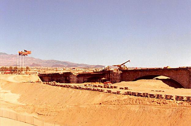
    <summary type="html"><![CDATA[<p><strong><em>While traveling the highways and rural paths of the American Southwest, it’s common to run into historical markers or monuments. In Lake Havasu City, Arizona, you can walk and drive along one that surprisingly originates from Great Britain.</em></strong></p><img src="https://www.intermountainhistories.org/files/fullsize/eb4a00dec8faaa2863b7452eb68fb4ca.jpg" alt="Construction of the London Bridge before a man-made canal was run along under it, Lake Havasu City, Arizona." /><br/><p>In 1958, entrepreneur and city planner Robert P. McCulloch envisioned a city in Western Arizona that would attract retirees and tourists. He purchased several thousand acres of land on the east side of Lake Havasu, a reservoir behind the Parker Dam along the Colorado River. The recreational aspect for his city was set, a dazzling blue and green lake set in contrast with the hot and red desert was sure to attract retirees. However, further appeal was needed to attract tourists and full time residents who would call the city home. A prospective attraction appeared in 1967, when it was found that one of the historic “London Bridges” along the Thames River in London, England was not structurally stable and would need to be replaced.
John Rennie of Scotland was the designer of the bridge, and completed its construction in August of 1831, replacing the original bridge constructed in 1209. When the officials found it structurally unsound in 1967, instead of demolishing it, they tried selling it. McCulloch’s oil company brokered a deal and bought the bridge’s exterior masonry for 2.46 million dollars at the end of 1967 (a sum worth almost 23 million dollars today when adjusted for inflation). Local newspaper <em>The Arizona Republic</em> reported the sale on April 19, 1968, writing that the bridge would “<em>serve as a centerpiece for the city’s leisure industry and an attraction to entice travelers to Lake Havasu City from transcontinental highways.”</em> The bridge that now exists only contains this exterior masonry. When shipment and construction began in 1968, they used a base concrete skeleton on which the veneer of the original stone masonwork was placed. The five arched bridge was built over a dip in the sandy earth of a peninsula jutting into Lake Havasu, through which a man-made canal was created. This made it so that the structure bridged together the newly created ‘Pittsburgh Point Island’ and mainland Lake Havasu City.
The bridge opened up with much fanfare and excitement in 1971. The opening ceremony featured a parade of flag-bearing boy scouts, fireworks, and the mayor of London who placed the foundation stone in 1968. Following construction, Lake Havasu City grew steadily because of efforts from McCulloch. He would fly in potential homebuyers, build hotels and stores on his own dime, plant palm trees to add greenery, and yes, even construct one of London’s famous bridges in the middle of the desert. What started as a dream in the desert has since turned into a city of over 57,000 people. Whether the London Bridge serves as a monument to foreign lands or a tourist trap is dependent on the visitor. But for those that live in this desert city, the bridge is one of the many attributes that makes them call Lake Havasu City home.</p><p><em><strong><a href="https://www.intermountainhistories.org/items/show/939">For more (including 5 images) view the original article</a></strong></em></p>]]></summary>
    <published>2026-02-02T17:22:18+00:00</published>
    <updated>2026-04-17T19:32:21+00:00</updated>
    <link rel="alternate" type="text/html" href="https://www.intermountainhistories.org/items/show/939"/>
    <id>https://www.intermountainhistories.org/items/show/939</id>
    <author>
      <name>Samuel Watson, Brigham Young University</name>
    </author>
  </entry>
  <entry>
    <title type="html"><![CDATA[Chico Hot Springs — Montana]]></title>
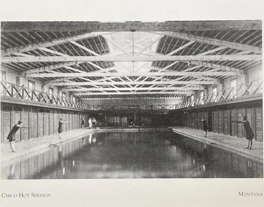
    <summary type="html"><![CDATA[<p><strong><em>Euro-American settlers converted these natural hot springs into a resort in the early 20th century, inviting travelers en route to Yellowstone National Park for a comfortable rest stop. After WWII, the site's ownership changed hands and converted Chico Hot Springs into a dude ranch, but the site's historic value and entertainment opportunities remained. </em></strong></p><img src="https://www.intermountainhistories.org/files/fullsize/35eaa6dfe7334e9b11c96e81dc2119ec.jpg" alt="Montana’s Hot Springs - Chico Hot Springs" /><br/><p><span>Chico Hot Springs sits within the Paradise Valley, where gold prospectors began mining in the 1860s. A gold miner wrote “went out to the hot springs and washed my dirty ‘duds” in a diary entry he dated to January 16, 1865, marking the first written record of these hot springs. As the Chico settlement developed in the 1880s, an investor named Walter Matheson announced his plans to construct a bathhouse in which locals and tourists could plunge into the spring’s steamy mineral waters. Matheson recognized that the Northern Pacific Railway’s completion would bring larger crowds through Montana, especially with the newly constructed Park Branch that ran through Paradise Valley and connected Livingston to Yellowstone National Park in 1883. He capitalized on this increased traffic by advertising to locals and railroad travelers of the relaxing and healthy qualities that dipping into the Chico Hot Springs offered. An 1893 article in <em>The Daily Enterprise, </em>Livingston, MT, noted that the facility became a popular tourist attraction, with visitors camping overnight near the springs. </span>
<span>Matheson passed his ownership of Chico Hot Springs down to his daughter, Percie, and her husband, William Knowles, before his death in 1893. With increasing patronage at the hot springs, Knowles recognized a lucrative opportunity in adding lodging and a dining room to the facility. Locals celebrated Chico Warm Springs Hotel’s grand opening in 1900, which unveiled the addition of hotel rooms, a hot plunge pool, gender-separated bathhouses, and a dance hall and saloon for evening social gatherings. Following Knowles’ death in 1910, Percie continued to manage Chico Hot Springs. She promoted the site’s medical services by closing the saloon and hiring an on-site physician to prescribe warm plunges in the springs to patients suffering from various ailments.</span>
<span>In 1948, Percie sold the Chico Warm Springs Hotel to Oneita Behnke, shifted the business’ focus toward entertainment in the following twenty years. Alongside swimming, visitors could participate in gambling, barbecues, rodeos, and square dancing. With the addition of livestock barns and corrals, Behnke renamed the business to “Chico Ranch” and began advertising the site as a dude ranch. The tourist appeal of Chico Hot Springs shifted once more when investors Mike Art and his wife Eve bought Chico Ranch in 1967 with intentions of restoring the business to its former purpose as a site of relaxation and recreation. He and his wife achieved this by remodeling the hotel, dining room, and pools, and renaming the business to “Chico Hot Springs Resort.” As a result, Chico Hot Springs became a modern, high-class getaway while retaining its historic architectural elements. </span>
<span>Chico Hot Springs Resort continues to be a popular Montana vacation site, offering hiking, horseback trail rides, outdoor garden walks, swimming, and a restorative plunge in the site’s natural hot springs. Its convenient location along Highway 89 continually draws automobile tourists to the site year-round. </span></p><p><em><strong><a href="https://www.intermountainhistories.org/items/show/912">For more (including 4 images) view the original article</a></strong></em></p>]]></summary>
    <published>2025-09-23T15:38:25+00:00</published>
    <updated>2026-04-17T19:32:21+00:00</updated>
    <link rel="alternate" type="text/html" href="https://www.intermountainhistories.org/items/show/912"/>
    <id>https://www.intermountainhistories.org/items/show/912</id>
    <author>
      <name>Alexandra Williams, Northern Arizona University</name>
    </author>
  </entry>
  <entry>
    <title type="html"><![CDATA[Antler Arch — Wyoming]]></title>
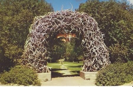
    <summary type="html"><![CDATA[<p><strong><em>Members of the Jackson Hole Rotary Club constructed the antler arch in 1953 as an installation that would capture the essence of the American West. Community members built the arch in the Jackson Hole Town Square, which is adjacent to Highway 89. </em></strong></p><img src="https://www.intermountainhistories.org/files/fullsize/012bb102c748391c0dd61daa10d08cf0.jpg" alt="Jackson WY-Wyoming, Elk Horn Arch, Scenic View" /><br/><p><span>Since its creation in 1953, the antler arch in Jackson Hole, Wyoming, has attracted countless Highway 89 travelers. Regardless of whether the destination is Jackson Hole itself or Grand Teton National Park further north, tourists often include a visit to the antler arch on their trip itinerary. The Jackson Hole Rotary Club developed an idea for a beautifying sculpture project in the Town Square in 1953. They agreed that the concept should capture the most iconic qualities of Jackson Hole, and that the sculpture itself may become a town icon. The same year, members of the Rotary Club asked locals to donate antlers for the construction of an arch made entirely of antlers. The Rotary Club initially planned to build one arch in Town Square, until the finished structure proved to be immensely popular, attracting large crowds of admiring people and individuals wanting to take photos beneath the arch. With such positive reception, the Jackson Hole Rotary Club began raising funds to build four more arches in the Town Square.</span>
<span> Due to the limited lifespan of natural elk antlers, the Jackson Hole community adopted the tradition of reconstructing the arch every 40-50 years. The Rotary Club developed this tradition to collaborate more with the community by partnering with local organizations. With the support of the U.S. Fish & Wildlife Service, local Boy Scouts began hiking into the National Elk Refuge annually in late April to acquire fresh antlers. The Rocky Mountain Elk Foundation then auctioned these antlers off at the Jackson Elkfest each year to raise funds for wildlife conservation. Individuals who purchased antlers at this auction typically donated them to the Rotary Club to help construct new arches or repair damaged ones in Town Square.</span>
<span>Both admiring and maintaining the Jackson antler arches are ongoing traditions in this town. With the National Elk Refuge, a home to one of the world’s largest elk herds, located just north of the town of Jackson, elk antlers are a fitting medium for an installation that aims to illustrate the town’s identity. Since their creation, the arches have been the site of various community events, including auctions, Christmas decorating, competitive winter sports registrations, Easter egg hunts, staged cowboy shoot-outs, and Wyoming Statehood Day celebrations. For tourists visiting Jackson or passing through on their way to a National Park, they are sure to catch a glimpse of the arches as they pass by the Town Square off of Highway 89. Automobile tourists often make a stop to take photos beneath the arches, capturing a symbol of the American West and Wyoming’s natural landscape.</span></p><p><em><strong><a href="https://www.intermountainhistories.org/items/show/911">For more (including 3 images) view the original article</a></strong></em></p>]]></summary>
    <published>2025-09-23T15:38:25+00:00</published>
    <updated>2026-04-17T19:32:21+00:00</updated>
    <link rel="alternate" type="text/html" href="https://www.intermountainhistories.org/items/show/911"/>
    <id>https://www.intermountainhistories.org/items/show/911</id>
    <author>
      <name>Alexandra Williams, Northern Arizona University</name>
    </author>
  </entry>
  <entry>
    <title type="html"><![CDATA[Bear Lake — Idaho-Utah]]></title>
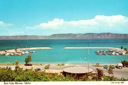
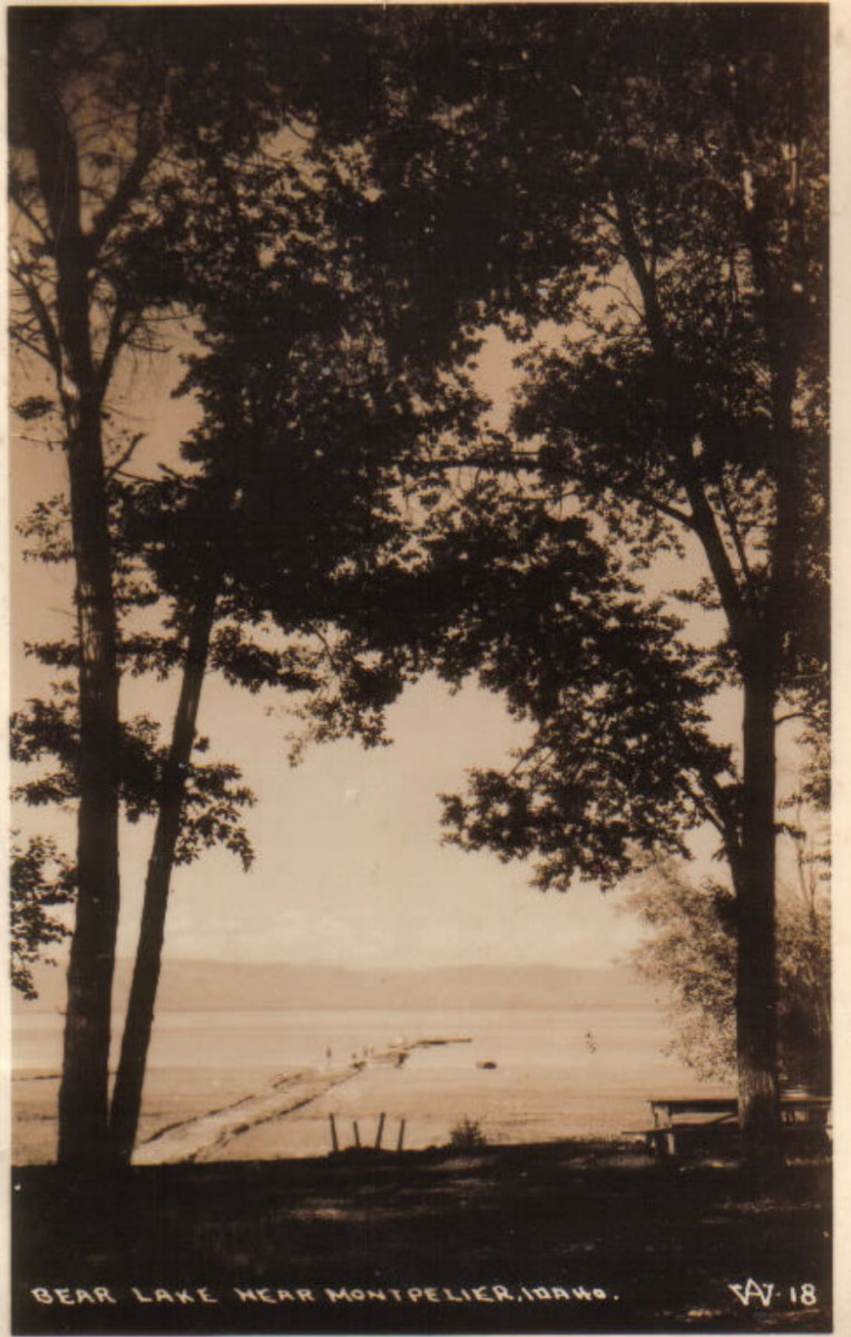
    <summary type="html"><![CDATA[<p><strong><em>Along Idaho’s forty-five-mile portion of Highway 89, travelers pass Bear Lake, a natural freshwater body that spans the Utah and Idaho state lines. The lake’s vibrant blue waters have attracted travelers and locals to enjoy its outdoor recreation opportunities since the arrival of Euro-American settlers. Regular visitors have referred to Bear Lake as the “Caribbean of the Rockies,” due to its bright blue color. </em></strong></p><img src="https://www.intermountainhistories.org/files/fullsize/a2052eb33acb8a79b958725076cfb96f.jpg" alt="Bear Lake Marina Idaho Vintage Postcard Collectible Scenic View" /><br/><p><span>Long before Euro-American settlers found Bear Lake, the Bannock, Shoshone, and Ute tribes frequented the surrounding landscape for hunting. U.S. military officers John Fremont and Benjamin Bonneville surveyed this area in 1842. Their findings paved the way for Oregon Trail travelers, who later traversed around the lake en route to Oregon. During the late 19th century, Bear Lake was an informal outdoor recreation site, attracting tourists from across the American West to enjoy boating, camping, fishing, hunting, and swimming at the lake’s bright blue waters. </span>
<span>Multiple ambitious locals recognized the site’s popularity and chose to open resorts with lodging and dining. By 1926, several private resorts operated on Bear Lake’s shores, including Bear Lake Hot Springs, Fish Haven, Ideal Beach, Lakota, and Logan Canyon. In the following decades, some of these facilities expanded to offer indoor entertainment, such as rollerskating at Lakota Resort and dancing at Fish Haven Resort. Alongside outdoor recreation, Bear Lake’s various resorts became popular sites for large gatherings like family reunions and school field trips. During the early-mid 20th century, the Bear Lake resorts received higher volumes of tourists between June and August, leaving their lodging facilities with no vacancies. The Bear Lake resorts would experience increased patronage following the extension of Highway 89 from St. Charles, Utah, to Paris, Idaho, in 1956. These businesses advertised the lake’s accessibility to Salt Lake City residents who could reach their summer getaway via the highway without being too far from home.</span>
<span>Recognizing the site’s popularity, the Utah Bureau of Land Management declared Utah’s portion of Bear Lake a state park in 1962 with plans to expand the marina and harbor that year. In 1963, the Idaho State Land Board designated the lake’s northern shore as a state park. It was not uncommon for travelers en route to Yellowstone National Park to stop and behold the unexpected beauty of Bear Lake. The site grew to such popularity in the 1970s that the two state parks closed temporarily and considered ways to control the expanding crowds. Members of the Bear Lake County Commission and the State Parks Commission in each state considered charging overnight campers additional fees, enforcing a maximum capacity, and enforcing boat speed limits. While the state park directors strove to allow the maximum number of visitors to enjoy the beaches, they agreed that certain regulations were necessary to promote a quality experience for all.</span>
<span>Bear Lake continues to be a popular outdoor tourist destination along Highway 89 throughout the year. Spring and summer visitors can enjoy biking, bird-watching, boating, camping, swimming, and water skiing, while winter visitors enjoy ice fishing for the native Bonneville Cisco whitefish. This unique fishing opportunity has made the lake a popular attraction for such an activity, especially when the fish spawn near the lake’s icy shores in late January each year. Even if highway travelers do not plan to stop at Bear Lake, its vibrant blue waters offer a uniquely scenic view as they cruise by on Highway 89.</span></p><p><em><strong><a href="https://www.intermountainhistories.org/items/show/910">For more (including 5 images) view the original article</a></strong></em></p>]]></summary>
    <published>2025-09-23T15:38:24+00:00</published>
    <updated>2026-04-17T19:32:21+00:00</updated>
    <link rel="alternate" type="text/html" href="https://www.intermountainhistories.org/items/show/910"/>
    <id>https://www.intermountainhistories.org/items/show/910</id>
    <author>
      <name>Alexandra Williams, Northern Arizona University</name>
    </author>
  </entry>
  <entry>
    <title type="html"><![CDATA[Big Rock Candy Mountain — Utah]]></title>
    <summary type="html"><![CDATA[<p><strong><em>After Harry McClintock released the song “Big Rock Candy Mountain” in 1928, Utah locals placed a sign at the base of a yellow mountain outside of Richfield, labelling it as the song’s namesake because they believed the scenic area matched McClintock’s lyrical description. After the song’s popularization in the 1950s, tourists along Highway 89 considered Utah’s Big Rock Candy Mountain an attraction itself. </em></strong></p><img src="https://www.intermountainhistories.org/files/fullsize/354f372af4646cdc53dcb45586facacb.jpg" alt="Big Rock Candy Mountain UT-Utah, Lemonade Springs, Antique, Vintage Postcard" /><br/><p><span>In his 1928 song, “Big Rock Candy Mountain,” the American folk singer Harry McClintock (1882-1957) sang of a fabled paradise that he described as being bathed in perpetual sunshine, free of danger and common stressors, and flowing endlessly with delicious food and drink. The song quickly gained national popularity, leading some Utah locals to place a sign at the foot of a colorful mountain outside of Richfield, which they believed resembled the one McClintock described in the song. For the mountain’s scenic views and association with the popular song, Big Rock Candy Mountain became a local tourist attraction. Two ambitious locals, Ben Dieringer and Pratt Seegmiller, capitalized on the site’s popularity by opening a resort, including a motel, café, gift shop, and fuel station at the foot of the mountain in 1933. </span>
<span>Utah locals recognized this mountain as one of Utah’s greatest natural wonders. The mountain’s vibrant colors resulted from mineralization that occurred after layers of hot magma covered the mountain’s volcanic rock and deposited an oxidized mineral, limonite, over twenty million years ago. Today, the mountain presents a combination of multiple vibrant colors, including orange, red, white, and yellow. Locals suggest that these bright colors make the mountain look as if it is made entirely of candy and is therefore deserving of its name.</span>
<span>Throughout the mid-20th century, the Big Rock Candy Mountain Resort became a popular roadside attraction along Highway 89 and a valued community center for the residents of Piute County. Travelers could fuel vehicles, enjoy a meal at the café, rest overnight, and purchase bottled mineral water and colorful rock candy from the curio shop. Beginning in the 1950s, Dieringer brought live animals to the resort, including coyotes, deer, mountain lions, porcupines, and lynxes, and allowed visitors to pet them. He believed these encounters could help people cultivate compassion for animals. Dieringer began hosting an annual Easter egg hunt. Advertisements in the <em>Richfield Reaper</em> invited families from the nearby town to spend their Sunday at the Big Rock Candy Mountain Resort, where children could search for Easter eggs he had hidden throughout the hills behind the resort. The 1950s and 1960s were Dierringer and Seegmiller’s prime years as business owners before they retired.</span>
<span>Dieringer and Seegmiller sold the Big Rock Candy Mountain Resort to Richfield resident John Gledhill in 1974. Two years later, a fuel pump ignited a fire, destroying the service station and motel. Gledhill rebuilt the resort in 1978 despite this setback. He owned the business for twenty years in total before he filed for bankruptcy in 1994 and offered the resort for auction. Dissatisfied with the auction’s turnout, Gledhill listed the property on the real estate market for $535,000.000 in 1995. Utah locals Michael and Anne Morrey purchased the property in 1997 and advertised the site as an ideal place for family reunions, where visitors could stay at the resort’s cabins, camp, hike, or ride ATVs on the surrounding outdoor trails.</span></p><p><em><strong><a href="https://www.intermountainhistories.org/items/show/909">For more (including 4 images) view the original article</a></strong></em></p>]]></summary>
    <published>2025-09-23T15:38:24+00:00</published>
    <updated>2026-04-17T19:32:20+00:00</updated>
    <link rel="alternate" type="text/html" href="https://www.intermountainhistories.org/items/show/909"/>
    <id>https://www.intermountainhistories.org/items/show/909</id>
    <author>
      <name>Alexandra Williams, Northern Arizona University</name>
    </author>
  </entry>
  <entry>
    <title type="html"><![CDATA[Cameron Trading Post — Arizona]]></title>
    <summary type="html"><![CDATA[<p><strong><em>Two businessmen founded this motel and curio shop in 1916 with tourists in mind, aiming to provide travelers with an “authentic” Southwestern experience. The trading post invited tourists to rest, indulge in a Southwestern-style cuisine, and browse a selection of authentic Navajo and Hopi arts and crafts. For these novelties, it remained a popular tourist attraction throughout the 20th century.</em></strong></p><img src="https://www.intermountainhistories.org/files/fullsize/e27f684a26c452aea3fbf91b29cbac3e.jpg" alt="Ariz. - Bridge at Cameron" /><br/><p><span>The Kansas City Midland Bridge Company constructed the steel suspension bridge over the Little Colorado River in 1911, making travel across the gorge more convenient. Brothers C.D. and Hubert Richardson saw an opportunity as they anticipated that this road would see more traffic following the bridge’s completion. In 1916, the Richardson brothers purchased 112 acres south of the bridge and built a wooden cabin as the center of their trading business. They served local Navajo and Hopi communities by trading livestock, rugs, skins, and wool in the company’s early years. As a public business in a remote area, increasing numbers of long-distance travelers visited Cameron Trading Post looking for a place to rest.</span>
<span>Cameron Trading Post became a convenient rest stop for travelers within the Four Corners region. As the site saw more patronage in the 1920s, the Richardson brothers constructed fuel pumps, a hotel, and a dining room adjacent to the trading post. Toward the mid-century, the Richardson family reported an influx of wealthy automobile tourists making stops at the Cameron Trading Post when traveling to and from the Grand Canyon. This adventurous class of automobile tourists traversing the Southwest sought the “authentic” regional experience at the trading post. Recognizing this site’s popularity, the Fred Harvey Company began including Cameron Trading Post as a stop along their Indian Detours, where guides drove tourists along rugged dirt roads to visit sights like the Painted Desert and the Grand Canyon. Cameron Trading Post was a routine stop along these tours. To cater to these travelers’ interests, the Richardson brothers filled the gift shop with cowboy hats and Native American arts and crafts. Tourists could browse from various Navajo and Hopi baskets, blankets, concho belts, pottery, and turquoise and silver jewelry.</span>
<span>Cameron Trading Post’s convenient location near the Little Colorado Bridge continued to attract droves of tourists when the federal government began regulating highways in 1925. The U.S. Bureau of Public Roads established the first stretch of Highway 89 that year, a route between Thistle, Utah, and Flagstaff, Arizona. This route provided travelers with convenient access to multiple national parks, including the Grand Canyon, Zion, and Bryce Canyon. Cameron Trading Post became a popular secondary tourist attraction along this route, offering travelers lodging, dining, and shopping with a uniquely Southwestern flair.</span>
<span>The Cameron Trading Post changed hands in 1966 when Hubert Richardson sold the business’s lease to Standard Oil and subleased the hotel, restaurant, and gift shop to the Fred Harvey Company. The trading post remained an international hub for trading Native American arts and crafts. Toward the end of the 20th century, Cameron Trading Post continued to add uniquely Southwestern elements to their business, including a fine art gallery displaying works of local artists, Navajo weavers demonstrating their craft while seated in the gift shop, and the option of ordering a Navajo taco in the dining room. Cameron Trading Post continues to offer an entertaining rest stop experience for travelers along Highway 89.</span></p><p><em><strong><a href="https://www.intermountainhistories.org/items/show/908">For more (including 4 images) view the original article</a></strong></em></p>]]></summary>
    <published>2025-09-23T15:38:23+00:00</published>
    <updated>2026-04-17T19:32:20+00:00</updated>
    <link rel="alternate" type="text/html" href="https://www.intermountainhistories.org/items/show/908"/>
    <id>https://www.intermountainhistories.org/items/show/908</id>
    <author>
      <name>Alexandra Williams, Northern Arizona University</name>
    </author>
  </entry>
  <entry>
    <title type="html"><![CDATA[MEDL, Flagstaff, AZ: The People Want Trails]]></title>
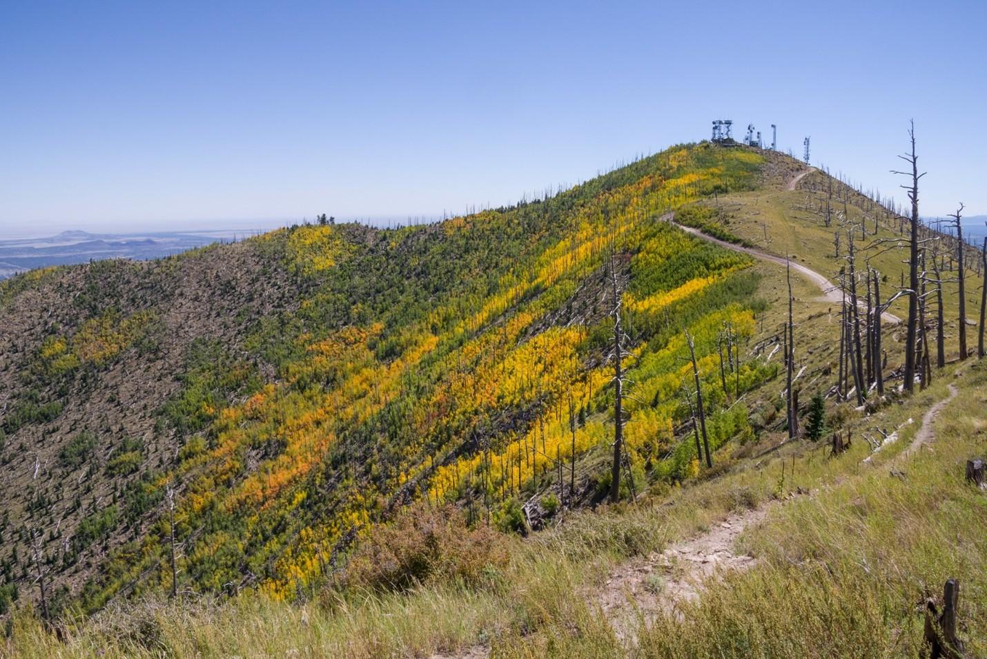
    <summary type="html"><![CDATA[<p><strong><em>The Mount Elden Dry Lake Hills trail system north of Flagstaff, AZ, traces its legacy of use closely with the history of the city. Dedicated in 1987, the network has steadily grown through community initiatives in cooperation with the Forest Service in Coconino National Forest to over 100 miles of trail. The proximity to town and rugged terrain give the illusion of a backcountry experience in an accessible frontcountry setting while the repurposing of game trails, sheepherding trails, fire breaks, and transportation lines maintains a connection to Flagstaff’s past.</em></strong></p><img src="https://www.intermountainhistories.org/files/fullsize/48b5ffa5c2b75a1821ff98ce917ee2a7.jpg" alt="Sunset Trail No. 23, Mount Elden" /><br/><p>As mountain biking developed around Marin County, CA, from the outfitting of WWII era “balloon tire” bikes with knobby tires and better brakes to more specialized equipment, two-wheeled recreation also began to take hold in the mountains and forests near Flagstaff, AZ. A local motorcycle club, the Coconino Motorcycle Trail Riders, connected remnants of the original Schultz Pass Road into a unified trail running up Schultz Creek in the 1970’s. When bicycle manufacturers began bringing bespoke mountain bikes to the market in the early 1980’s, Flagstaff’s existing cycling culture made for a quick uptake of the new machines. Mechanic Steve Garro of local shop Cosmic Cycles and the counterculture mountain bike racing team The Mutants joined other hobbyists to set about exploring the higher elevations accessible by Schultz Pass and Elden Lookout roads.
A series of disused wagon routes from the early 1900’s, old communications lines servicing the first lookout towers, fire breaks from the 1977 Radio Fire, and the plethora of livestock and game trails on the slopes were connected to unify the upper elevations of Mount Elden with the lower Dry Lake Hills to the west. As the trail network grew and diversified, so did the user base and rate of conflict. Many trails were closed to mountain bike access after unfavorable interactions with hikers and equestrians. After the forest service officially dedicated the Mount Elden Dry Lake Hills trail system in 1987, local advocacy groups successfully lobbied to restore mountain bike access and employed a code of conduct wherein cyclists were to yield to hikers or equestrians. 
As mountain bikes modernized into the 2000’s and usage expanded, MEDL supervisors recognized that mitigation of environmental damage induced by increased traffic was necessary. In 2006, the Flagstaff Bicycle Organization began advocating for directional downhill trails in the MEDL network to minimize hiker-biker interactions. Following the Schultz Fire in 2010, the forest service advanced a comprehensive trail planning scheme accounting for fire risk, endangered species protection, reduced user conflict, and local quality of life improvement. The proposed MEDL trail plan specifically focused on environmental protection and improved recreational access for residents over tourism.
Though delayed by thoughtful debate with groups like the Sierra Club, and the Museum Fire in 2019 that burned existing paths and planned expansion, the realignment of several traverses on erosive slopes in 2020 proved the venture worthwhile. The subsequent effort between the forest service and volunteer mountain bike, trail running, and motorcycle groups to professionally mark and build sustainable routes across the MEDL network garnered community support. The ongoing project has improved or created over twenty-five miles of trail since 2022 including the first sanctioned, directional mountain bike trails in Flagstaff – called Meteoride and Full Sail. The city’s assets in the sciences and passionate volunteer advocacy groups have allowed for thorough planning in current and future trail building that is as mindful of the protection of the mountain’s fragile ecology as it is of the improved quality of life that outdoor recreation can bring the community.  </p><p><em><strong><a href="https://www.intermountainhistories.org/items/show/906">For more (including 4 images) view the original article</a></strong></em></p>]]></summary>
    <published>2025-09-23T15:36:55+00:00</published>
    <updated>2026-04-17T19:32:20+00:00</updated>
    <link rel="alternate" type="text/html" href="https://www.intermountainhistories.org/items/show/906"/>
    <id>https://www.intermountainhistories.org/items/show/906</id>
    <author>
      <name>Nicholas Nation, Northern Arizona University </name>
    </author>
  </entry>
  <entry>
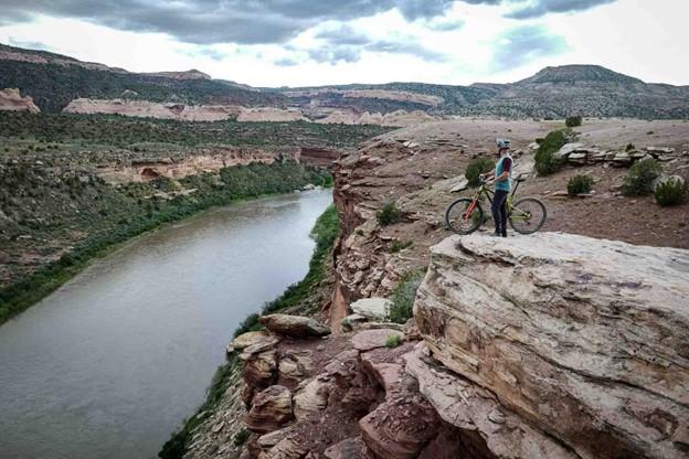
    <title type="html"><![CDATA[Kokopelli’s Trail, Loma, CO: In Pursuit of Solitude]]></title>
    <summary type="html"><![CDATA[<p><strong><em>Stretching 142 miles between Loma, CO, and Moab, UT, Kokopelli’s Trail is one of the earliest publicized examples of a backcountry mountain biking route. The unification of Kokopelli’s in 1989 by the Colorado Plateau Mountain Bike Trail Association helped popularize a new brand of distance cycling – bikepacking - and inadvertently made the American Southwest one of the best-known bikepacking destinations in the world. </em></strong></p><img src="https://www.intermountainhistories.org/files/fullsize/ec7c7c9ba0710082ba17aaf9f08f0443.jpg" alt="View of Kokopelli Trail Grand Junction" /><br/><p>When mountain bikes became commercially available in the early 1980’s, wealthy baby boomers from coastal California began to explore the west on their new machines enticed by the vast landscapes and inexpensive accommodation. Moabites recognized the economic opportunity afforded by mountain bike tourism and by the late 1980’s Moab, UT, had become a premier cycling destination. While the highly publicized Slickrock Trail was leveraged to draw visitors in, the vast network of 4x4 roads surrounding the town, relics of a defunct uranium industry, began to see increased use among cyclists. Nearby Grand Junction, CO, was experiencing similar backcountry traffic in the late 1980’s. Grand Junction Bureau of Land Management officials observed illegal mountain bike use in the Black Ridges Wilderness Study Area threatening to undermine ecological research. BLM area manager John Singlaub sought to protect the wilderness without alienating cyclists and proposed BLM recreation planner Carlos Sauvage build a cycling route on non-wilderness lands along the Colorado River. Lacking funding, the BLM turned to mountain biker and Grand Junction lawyer Timms Fowler to help plan and coordinate the effort. Long dreaming of a unified route across the remote region, Fowler jumped at the opportunity to aid in the construction.
Beginning in November of 1988, Sauvage and other BLM personnel began driving and mapping the dozens of dirt roads abandoned by the uranium industry between the route’s planned start point in Loma, CO, and terminus in Moab, UT. Meanwhile, Fowler set up meetings with bike shops in Grand Junction and Moab to secure volunteer support for the project. After identifying a course on 4wd tracks, BLM workers planned ten additional miles of singletrack trail to access scenic vistas and ensure an engaging riding experience. A volunteer building effort commenced in the spring of 1989 under the newly formed Colorado Plateau Mountain Bike Trail Association and after six weekends of construction, the 142 mile long Kokopelli’s Trail was completed. On May 6<sup>th</sup>, 1989, the Hopi Flute Clan for whom the trail was named held a ceremony under elder Ebin Leslie in Cisco, UT, the halfway point, to officially open Kokopelli’s to the public.  
Kokopelli’s quickly generated interest among mountain bikers. The high level of community engagement guaranteed considerable public awareness of the project and increased ridership. Proximity to major throughfares like Interstate 70 and Highway 191 made for easy access to the trail. The federal officiating in route creation and surveying resulted in an abundance of maps and backcountry planning resources for prospective users. The trail’s position on BLM land made it popular among bikepackers, backcountry cyclists who pursue multi-day, self-supported rides, because of the relaxed camping regulations imposed on remote public lands. The vastness of the landscape Kokopelli’s Trail traverses and the solitude afforded by its 142 miles in length made for an experience difficult to capture elsewhere and secured the Southwest as a stronghold for backcountry mountain biking.</p><p><em><strong><a href="https://www.intermountainhistories.org/items/show/905">For more (including 3 images) view the original article</a></strong></em></p>]]></summary>
    <published>2025-09-23T15:36:54+00:00</published>
    <updated>2026-04-17T19:32:20+00:00</updated>
    <link rel="alternate" type="text/html" href="https://www.intermountainhistories.org/items/show/905"/>
    <id>https://www.intermountainhistories.org/items/show/905</id>
    <author>
      <name>Nicholas Nation, Northern Arizona University </name>
    </author>
  </entry>
  <entry>
    <title type="html"><![CDATA[Gooseberry Mesa National Recreation Trail, Hurricane, UT: We Can Ride Too]]></title>
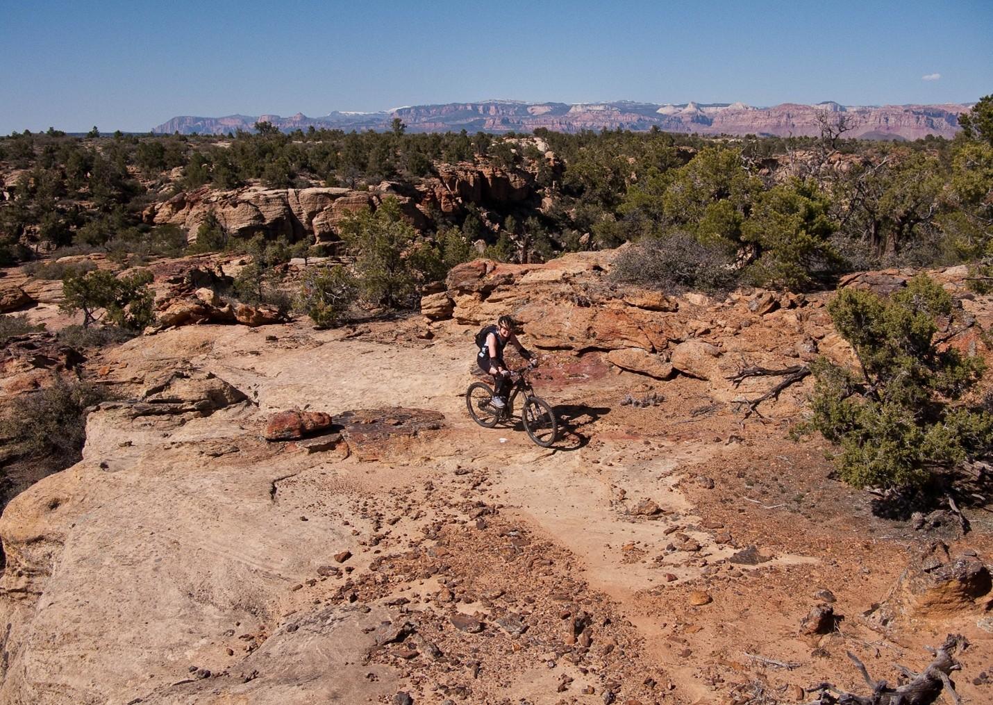
    <summary type="html"><![CDATA[<p><strong><em>After Mike and Morgan Harris started building the trail system now called Gooseberry Mesa National Recreation Trail in the early 1990’s, they had no idea it would become such a significant attraction to the mountain biking community. Situated eight and a half miles from Hurricane, Utah, and twenty miles southwest of Zion National Park, “The Goose” as it’s affectionately known is one of the most scenic riding centers on the Colorado Plateau.  </em></strong></p><img src="https://www.intermountainhistories.org/files/fullsize/7071445632eb7a04a4404768333d12d1.jpg" alt="Harris Secret Trail" /><br/><p>When Mike and Morgan Harris relocated to Hurricane, UT, in the early 1960’s, Gooseberry Mesa was a seldom frequented parcel allocated to the Bureau of Land Management that remained unused on account of the tight, maze-like topography. The water holding capacity of the rock that caps the mesa, Shinarump conglomerate, enables an ecology with pockets of lush vegetation frequented by game populations. The Harris’ early exploration of the mesa was as a hunting ground. Their use of motorcycles and frequent hikes through the formation gave them an intimate knowledge of the landscape and route-finding abilities that others lacked.
While the Harris’s were hunting the mesa, mountain biking had slowly been moving into the rural West. The fledgling sport originated in the late 1960’s in Marin County, CA, when a group of teens started riding single-speed “balloon tire” bikes up and down Mt. Tamalpais. After noticing cycling clubs optimizing old bikes for offroad races in the 1970’s, major manufacturers developed consumer market bicycles for the harsher settings mountain bikers were riding in the early 1980’s. Enticed by the new trend and cheap, rural accommodation, wealthy baby-boomers bought in and began to explore the Colorado Plateau. Moab’s Slickrock Trail came to be the pinnacle mountain biking destination in the late 1980’s and after a visit in 1993, Mike and Morgan realized their secluded hunting ground would be an ideal venue to develop deliberate mountain bike paths.
Upon returning from Moab, the Harris’ scouted and marked a primitive trail network across the twenty-four square miles of Gooseberry Mesa. Their approach attempted to fully immerse riders in the terrain by utilizing the entirety of the landscape. Though both were inexperienced riders and still honing their skills, their recognition that mountain biking equipment was consistently improving lead them to pursue increasingly challenging obstacles. They offered the spectacular scenery afforded by the mesa’s 2000 feet of prominence over the badlands below as a reward for each completed section. While their Gooseberry trails lacked the elevation gain and loss of Slickrock in Moab, they engaged mountain bikers by keeping difficult trail features like near vertical ascents and descents hidden around corners or behind foliage affording little time to prepare for each challenge. The construction style they helped popularize made riding acumen more important than quality of gear earning popularity among hobbyists and professionals alike.
After hearing that other builders were fined for similar unsanctioned work, the brothers turned themselves in to the BLM and facilitated a visit with federal officials to the mesa. To their surprise, BLM personnel were so impressed with the work that measures were taken to officially adopt the tracks resulting in their designation as the first official mountain biking trails in Washington County, Utah, on October 26<sup>th</sup>, 1999. Seven years later in 2006 the routes were upgraded to National Recreation Trail status by the BLM, an accolade that demonstrates a commitment to continued use, sustainable environmental practice, and an anticipated increase in tourism for the surrounding communities.</p><p><em><strong><a href="https://www.intermountainhistories.org/items/show/904">For more (including 3 images) view the original article</a></strong></em></p>]]></summary>
    <published>2025-09-23T15:36:54+00:00</published>
    <updated>2026-04-17T19:32:20+00:00</updated>
    <link rel="alternate" type="text/html" href="https://www.intermountainhistories.org/items/show/904"/>
    <id>https://www.intermountainhistories.org/items/show/904</id>
    <author>
      <name>Nicholas Nation, Northern Arizona University </name>
    </author>
  </entry>
  <entry>
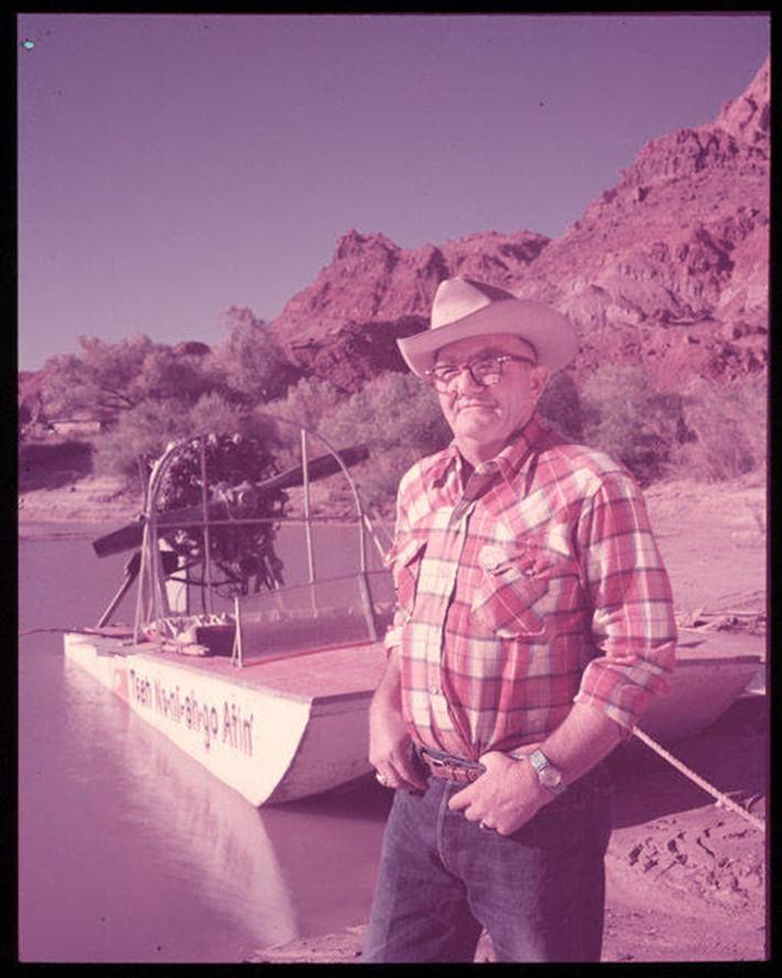
    <title type="html"><![CDATA[Art Greene and Lake Powell]]></title>
    <summary type="html"><![CDATA[<p><strong><em>Lake Powell is one of the largest reservoirs in the country by both volume and length, with almost a hundred side canyons extending into the surrounding arid, red-hued lands of southern Utah. Its waters quickly became a hub for outdoor recreation, with concessionaires like Art Greene pioneering desert boat-driven tourism.</em></strong></p><img src="https://www.intermountainhistories.org/files/fullsize/b3e159b1b55fa0b91b08098f58109e64.jpg" alt="Art Greene and his commercial river craft, the Tseh Na-ni-ah go Atin (Diné for “trail to the rock that goes over”, in reference to Rainbow Bridge), ca. 1949-1956" /><br/><p>The Glen Canyon Dam, which spans the Colorado River by the Utah-Arizona border, created Lake Powell in 1963. The lake submerged Glen Canyon to hold water and generate energy, and it remains a contested environmental issue. Nonetheless, Lake Powell attracts millions of visitors a year. Congress created the Glen Canyon Recreation Area (GCRA) in 1972 to center the region around leisure just as much as conservation. GRCA also borders Rainbow Bridge National Monument, only accessible by boat or a lengthy hike from the Navajo Nation. Rainbow Bridge, whose establishment predates that of GCRA, holds spiritual significance for nearby Indigenous tribes and attracts visitors looking for a trip “off the beaten path.” As Lake Powell’s waters rose, however, Rainbow Bridge and other surrounding features became more accessible for those traveling by boat.
            Art Greene was an early entrepreneur in the Glen Canyon who provided visitor services before Lake Powell was even created. Previously working as a river guide, cowboy, and oil rigger, to name a few, Greene and his family moved to Arizona from Colorado in 1943. They went on to manage the Marble Canyon Lodge, then bought the Cliff Dweller’s Lodge just down the road in 1949. The lodges, located near the Utah-Arizona border, catered to early river runners and outdoor enthusiasts. Greene launched the first commercial river trips upriver from Lee’s Ferry to Rainbow Bridge (a route that would be interrupted by the dam’s creation). Earl Johnson, his son-in-law, was the main supervisor of the river trips.
As early as 1945, Greene had noticed dam site surveyors in the area, and, after suspecting that the dam would disrupt his business downriver, he jumped at the prospect of lucrative lake tourism. The family acquired a commercial lease on the state grazing land nearby, planning lodging and recreation facilities. The Greenes also built a road, airstrip, and employee infrastructure in the area. The National Park Service (NPS), which had taken over administration duties from the Bureau of Reclamation, granted the Greene family a concession in 1959 to continue construction of the recreation area, now called Wahweap Marina.
By 1966, the family had worked with NPS to develop lodgings and boat ramps, a $3 million project to provide full access to America’s newest “playground”. Earl Johnson ran lake tours aboard boats like the <em>Rainbow</em> <em>Trail</em> for the family’s Canyon Tours, Inc. These tours ranged from daily trips to Rainbow Bridge to five-day overnight excursions. Tour boats brought passengers to features like the Glen Canyon Dam and the various side canyons of Lake Powell. Alongside guided tours, Canyon Tours owned a fleet of rental crafts for private use. As tourist rates increased, the family operation sold its concession to the Del Webb Corporation, a national developer of real estate and recreation properties, in 1976.
Today, Lake Powell’s low water levels not only hinder its water storage and power generating capacity, but also the ability to access features like Rainbow Bridge by boat. Guided tours persist, but are completely dependent on evaporation and drought conditions. Lake Powell still functions as a recreation hub for desert-dwellers in search of rare days on the water, as well as visitors from outside the West looking for deserts, canyon walls, and wide-open spaces.</p><p><em><strong><a href="https://www.intermountainhistories.org/items/show/893">For more (including 6 images) view the original article</a></strong></em></p>]]></summary>
    <published>2025-09-23T15:30:20+00:00</published>
    <updated>2026-04-17T19:32:20+00:00</updated>
    <link rel="alternate" type="text/html" href="https://www.intermountainhistories.org/items/show/893"/>
    <id>https://www.intermountainhistories.org/items/show/893</id>
    <author>
      <name>Anaëlle DePoint, Northern Arizona University</name>
    </author>
  </entry>
  <entry>
    <title type="html"><![CDATA[Grand Teton National Park and Jenny Lake]]></title>
    <summary type="html"><![CDATA[<p><strong><em>Established in 1929, Grand Teton National Park (GTNP) is known for its iconic landscape of the Teton Range, as well as its glacial lakes that dot its foothills and wildlife that fill the Jackson Hole valley. Jenny Lake, lying at the foot of the mountains, has long been a jumping-off point for visitors eager to explore the park’s many attractions. </em></strong></p><img src="https://www.intermountainhistories.org/files/fullsize/13852c02bc409ba82f38315a626b2a97.jpg" alt="Kenneth Reimer’s cabin" /><br/><p>Grand Teton National Park (GTNP) is located in northwestern Wyoming and often attracts visitors eager to experience the West’s scenery and “rustic” qualities. Homesteaders entered the area in the 1800s, but soil and climate conditions made it hard to raise cattle and crops. The area turned to outdoor recreation activities as its economic drivers, attracting upper-class East Coasters looking for the authentic “Western” experience. Hurried cabins, saloons, and large advertisements sprang up in the 1920s. The area’s natural environment was in quick danger of overdevelopment when John D. Rockefeller, Jr., emerged on the scene.
            The East Coast philanthropist wanted to protect the Tetons under the model Yellowstone had set in 1872. President Theodore Roosevelt established the Teton National Forest in 1908, but plans of damming lakes and residential constructions still threatened the area. Local ranchers and hoteliers strongly opposed federal encroachment on their ventures. After touring the area in 1926, Rockefeller was determined to conserve the Tetons regardless of political opposition, quietly buying up large plots of land to give to the federal government. President Calvin Coolidge established GTNP in 1929 at half its current size. After some legal and political difficulties questioning the billionaire’s influence, President Franklin D. Roosevelt took Rockefeller’s land and turned it into the Jackson National Monument in 1943. President Harry Truman combined the monument with GTNP in 1950 to complete the park as it is today.
            Although such actions protected the Tetons from rampant development, concessionaires were still permitted to build visitor services. Jenny Lake, the largest undammed lake in the park, was recognized for its natural beauty long before the park was officially created. During the 1920s, Charles J. Wort had already been renting motor and row boats to visitors under a National Forest Special Use Permit. Along with his Jenny Lake operations, Wort had also built lodges across the park. After Congress established GTNP, the National Park Service (NPS) granted him the first concession in Grand Teton and included him in its first Master Plan, which outlined plans for development in the park. After Wort’s death, Kenneth Reimer took over boating concessions on Jenny Lake in 1935. Civilian Conservation Corps crews had developed Jenny Lake’s trail system and west boat dock in the 1930s, encouraging the expansion of shuttle boat services across the lake. Following the “rustic” architectural guidelines set by NPS, Reimer also built a personal residence near Wort’s boathouse.
The Jenny Lake area is still a hub for NPS administration facilities and recreation. Along with other visitor infrastructure in the area, the west boat dock at the mouth of Cascade Canyon has been renovated multiple times over the last century. Most prominently, the Jenny Lake Renewal Project in 2018 improved the west boat dock for easier access to trails and lookouts. Along with rental boats, the current boat concession shuttles mountaineers intent on scaling the range’s world-famous faces, as well as visitors of all backgrounds looking to enjoy Jenny Lake’s scenery. Just as they did in the park’s early days, passengers can step on foot the shuttle, peering up at the towering Teton Range, eager to embark on their adventures. </p><p><em><strong><a href="https://www.intermountainhistories.org/items/show/892">For more (including 6 images) view the original article</a></strong></em></p>]]></summary>
    <published>2025-09-23T15:30:20+00:00</published>
    <updated>2026-04-17T19:32:20+00:00</updated>
    <link rel="alternate" type="text/html" href="https://www.intermountainhistories.org/items/show/892"/>
    <id>https://www.intermountainhistories.org/items/show/892</id>
    <author>
      <name>Anaëlle DePoint, Northern Arizona University</name>
    </author>
  </entry>
  <entry>
    <title type="html"><![CDATA[Waterton-Glacier International Peace Park and the International]]></title>
    <summary type="html"><![CDATA[<p><strong><em>Waterton-Glacier International Peace Park is a first-of-its-kind testament to the friendship between Canada and the United States. Glacial lakes, dramatic mountain faces, and abundant wildlife are just a few of the Glacier and Waterton Lakes’ shared features. The parks also feature the enduring craftsmanship of Captain J. W “Billy” Swanson, the prolific boat builder in the region.  </em></strong></p><img src="https://www.intermountainhistories.org/files/fullsize/24000f0abc2a900799c63e97227350e5.jpg" alt="The International, tinted-lantern slide, 1927" /><br/><p>In 1932, local rangers and Rotary Club members joined Glacier National Park (Montana, U.S.A.) and Waterton-Lakes National Park (Alberta, Canada) due to their contiguous landscape, similar ecosystems, and collaborative nature of their management. Though not erasing the international border, Glacier and Waterton already shared strong economic forces, like the Great Northern Railroad. The railroad’s Glacier Park Hotel Company (GPHC) built various chalets and hotels across Glacier, but its only Canadian property, the Prince of Wales Hotel, is emblematic of the international drive for nature-based tourism.
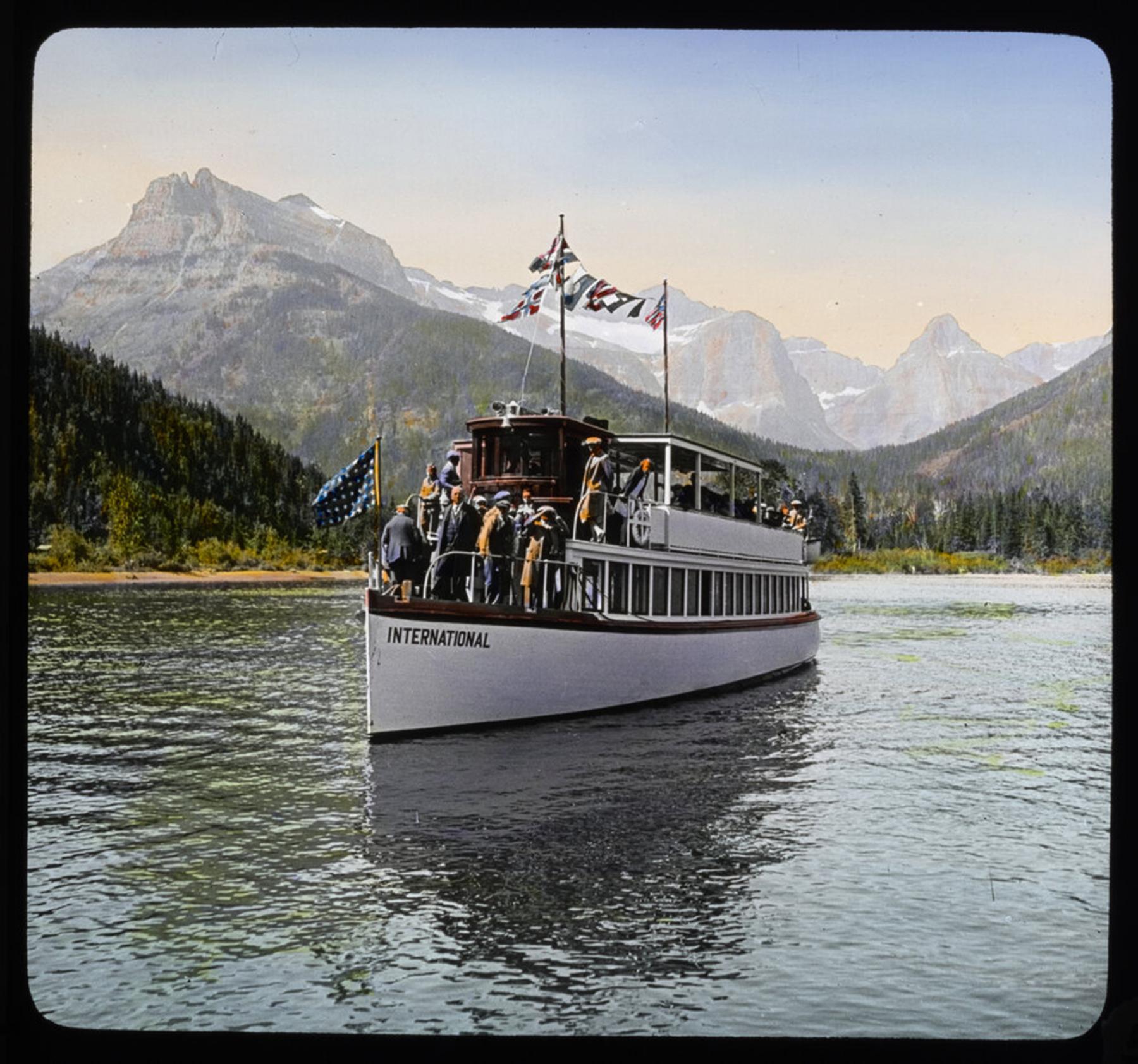
Opening in 1927, the sophisticated Prince of Wales Hotel needed travel amenities suitable for its upper-class clientele. The GPHC turned to Captain J.W. “Billy” Swanson, the prominent boat builder from Glacier National Park, to build his largest, grandest vessel: the <em>International</em>. To avoid Canadian labor and customs restrictions, the company insisted that Swanson build and register the boat on U.S. soil, even though it primarily served Canadian guests. The 250-passenger vessel was to transport guests to the remote Goat Haunt Chalet on the south side of Upper Waterton Lake. The <em>International </em>would also provide comfort and luxury to those coming from the chalet after a long trip on horseback. Though within Glacier’s borders and accessible via the park’s trail system, the backcountry chalet was easier to get to by boat from the lake’s Canadian side. However, materials were difficult to transport from Kalispell, about 150 miles away in Montana. Another boat concessionaire hauled parts for Swanson across the lake to Goat Haunt initially, but after the Captain deemed transportation prices too high, he simply built his own freighter boat. He and his small crew assembled the <em>International </em>in just two months, launching it on Upper Waterton Lake from the Prince of Wales Hotel in the summer of 1928.
Divided almost equally by the Canadian-American border, Upper Waterton Lake offers astounding views no matter which country one is in. However, some differences made the scenic trip even more sought-after from the Canadian side. The Prince of Wales Hotel initially drew Americans avoiding Prohibition laws, but by 1934, when they were repealed, Alberta still had restrictions on dancing and alcohol on Sundays. Despite the Great Depression, the vessel’s trips to the lake’s American side kept the <em>International </em>afloat. Canadians eager to escape Alberta laws hopped aboard her varnished, electrically lit deck for a good time, if only for a couple of hours.
Swanson had sold his Glacier operations by 1938 and moved on to other boat-building projects. However, as Canada entered World War Two in 1939, concession operations soon halted in the parks, though the <em>International </em>operated until 1940. The hiatus led to the neglect and eventual razing of Goat Haunt Chalet. The <em>International</em>, though, continues to transport Waterton-Glacier visitors across the lake, allowing them to experience a one-of-a-kind ride in a one-of-a-kind park.</p><p><em><strong><a href="https://www.intermountainhistories.org/items/show/891">For more (including 6 images) view the original article</a></strong></em></p>]]></summary>
    <published>2025-09-23T15:30:19+00:00</published>
    <updated>2026-04-17T19:32:20+00:00</updated>
    <link rel="alternate" type="text/html" href="https://www.intermountainhistories.org/items/show/891"/>
    <id>https://www.intermountainhistories.org/items/show/891</id>
    <author>
      <name>Anaëlle DePoint, Northern Arizona University</name>
    </author>
  </entry>
  <entry>
    <title type="html"><![CDATA[Glacier National Park’s Fleet and Captain J.W. “Billy” Swanson]]></title>
    <summary type="html"><![CDATA[<p><strong><em>Glacier National Park boasts a sprawling alpine landscape, with dozens of glacial lakes nestled between mountain faces and valleys. One concessionaire and expert craftsman, Captain J.W. “Billy” Swanson, constructed fleets of scenic cruisers and smaller boats that would allow visitors to soak in all Glacier had to offer.</em></strong></p><img src="https://www.intermountainhistories.org/files/fullsize/99b8e82e63e17fc192c50ed163a91c67.jpg" alt="Map of some of Captain J.W. Swanson’s Boats in Glacier National Park, with original launch sites, c.a. 1915-45, National Park Service (modified)" /><br/><p>Congress established Glacier National Park, located in northern Montana and close to the Canadian border, in 1910. The 1892 arrival of the Great Northern Railroad in the area facilitated an uptick in national park tourism. Glacier’s peaks and clear waters mirrored those featured in the traditional, lengthy European vacation. Early hotel concessionaires recognized this parallel and fashioned lodgings like Swiss chalets. Hiking trails and saddle ride routes first expanded access to the park, but as visitation increased, tourists wanted more comfortable, accessible ways to experience Glacier. Not only could boats link tourists to trails across lakes, but it could also connect guests from nearby towns to the park. Automobiles became the most efficient way to travel upon the completion of the Going-to-the-Sun Road in 1933, but boating remained a uniquely scenic way to explore the park.
Even before the federal government established Glacier, entrepreneurs were providing visitor services on Lake McDonald. By 1895, George Snyder purchased a steamship to ferry guests across the length of Lake McDonald to his hotel at the top, a trip that would often take an entire day.
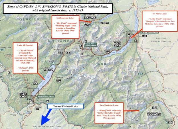
As Glacier’s popularity rose, so did the demand for boat travel. Captain J.W. “Billy” Swanson was the park’s most prominent boat concessionaire and builder for three decades. After running a boat-building operation on nearby Flathead Lake, Swanson moved his business to Glacier’s west side in 1911. He was known for his quality craftsmanship, ambitious personality, and willingness to go to extreme lengths in ensuring his boats’ success. In 1915, he hauled his steamship <em>City of Polson</em>, built for the Lewis Hotel owner John Lewis, upriver through a narrow canyon from Flathead Lake. After traveling over muddy, primitive roads to Lake McDonald, it was renamed <em>Lewtana</em> for ferrying and scenic touring on the lake.
Amongst other concessionaires, the captain built boats for the Great Northern’s tourism subsidiary, Glacier Park Hotel Company (GPHC). In 1920, the National Park Service granted him his own concession permit to build scenic cruisers and rental boats in Glacier’s eastern region. He built the <em>Little Chief </em>(St. Mary Lake) and the <em>Rising Wolf</em>  (Two Medicine Lake) for the GPHC in 1926. The company also commissioned the <em>International</em> for its Canadian-American operation in 1927. He returned to west Glacier to build the <em>DeSmet </em>for the Glacier Park Transport Company, another boat and bus tour concessionaire, in 1930. When Swanson’s finances declined in 1938, the Glacier Park Boat Company (GPBC) bought the captain’s boats and concession rights. Arthur Burch, the company head, ran the boats with Swanson until World War Two broke out. In 1945, they built the <em>Big Chief</em> on Swiftcurrent Lake together. This boat would turn out to be the captain’s last in Glacier.    
Captain Swanson maintained good relationships with park administrators and other concessionaires. Swanson’s superior craftsmanship is his strongest legacy, though. The GPBC, still run by the Burch family, operates with Swanson’s original fleet. Even though a century has passed, modern passengers can ride across the same waters, stand on the same decks, and view the same scenic landscapes that so many enjoyed before them.</p><p><em><strong><a href="https://www.intermountainhistories.org/items/show/890">For more (including 6 images) view the original article</a></strong></em></p>]]></summary>
    <published>2025-09-23T15:30:19+00:00</published>
    <updated>2026-04-17T19:32:20+00:00</updated>
    <link rel="alternate" type="text/html" href="https://www.intermountainhistories.org/items/show/890"/>
    <id>https://www.intermountainhistories.org/items/show/890</id>
    <author>
      <name>Anaëlle DePoint, Northern Arizona University</name>
    </author>
  </entry>
  <entry>
    <title type="html"><![CDATA[Yellowstone Lake’s Steamships and the Legacy of E.C. Waters]]></title>
    <summary type="html"><![CDATA[<p><strong><em>Yellowstone Lake, in Yellowstone National Park, is the largest high-elevation lake in North America. Visitors arrive eager to take in the mountains, glacial waters, and wildlife that surround it. Concessionaire E.C. Waters ran a lucrative steamship operation transporting guests across its waters for two decades, but his business practices and violations of park regulations led to its downfall.</em></strong></p><img src="https://www.intermountainhistories.org/files/fullsize/68c1a5bf36f9944b8e2ad2d694d1d81e.jpg" alt="Map of Yellowstone Lake area, National Park Service (modified)" /><br/><p>Congress established Yellowstone in 1872 as the country’s first and largest national park. Soon after, potential concessionaires flocked to build visitor services within park boundaries. In choosing leaseholders, early administrators strove to balance conservation and tourist accessibility. Increased transportation options would bring more people to the area, companies argued, and encourage the government to allocate funds to protect Yellowstone from vandalism and poaching. In 1886, following a decade of haphazard operations, the Yellowstone Park Association (YPA) took advantage of the park’s rise in popularity. The Northern Pacific Railroad-financed company took over property leases from the previous bankrupt concessionaire. The sites spanned across the park, including one at Yellowstone Lake.
E.C. Waters began as the general manager of the YPA’s hotels in 1887. Aiming to improve the quality of park-wide accommodations, the company planned a sophisticated hotel located on Yellowstone Lake. The site’s remoteness called for boat transportation, as stagecoach travel could be uncomfortable and slow. In 1889, the YPA named Waters president of its Yellowstone Lake Boat Company to meet this demand.
The entrepreneur, though, was already making enemies across the company and the Interior Department. In 1890, the YPA fired him for extortion, poaching, and a geyser’s eruption by throwing soap into it. Yellowstone officials barred him from the park, but his connection with President Benjamin Harrison’s son got him reinstated that same year. In 1892, the Interior Department granted him a permit to transport visitors on his steamship, the <em>Zillah</em>, from Thumb Bay to the Lake Hotel area. The 125-passenger vessel was sent piece-by-piece from Minnesota and reassembled at the lake. By 1896, the <em>Zillah</em> was making stops at E.C. Waters' “zoo” on Dot Island. It was a little more than some corralled bison and elk, which he shipped in from outside the park. Passengers were unknowingly charged extra by Waters for the quick stop. To make matters worse, the bison and elk starved as his finances declined and operations fell into disrepair. Park administrators and visitors questioned the <em>Zillah</em>’s lakeworthiness, Waters’ concession license, and his overall moral character.
Regardless, Waters built another steamship, the <em>E.C. Waters</em>, in 1905. It could carry 500 passengers, a violation of the park’s capacity limits. Fed up with his antics, park administrators refused to reinstate his lease and booted Waters from Yellowstone in 1907. A 1921 storm berthed the <em>E.C. Waters</em> on an island close to the hotel without ever transporting a single visitor. Park officials salvaged its parts over the next decades, most notably its boiler, which heated the Lake Hotel until the mid-twentieth century. What exactly became of the <em>Zillah</em> is unknown. Boat concessions continued after E.C. Waters sold his company in 1907, but the days of steamships and zoos were gone. Now, officials restrict lake operations to a tour boat, some motorboats, and paddle sports like kayaks. Visitors can still spot the skeleton of the <em>E.C. Waters</em> where it was shipwrecked years before, a testament to the hubris and ambition of its namesake.</p><p><em><strong><a href="https://www.intermountainhistories.org/items/show/889">For more (including 6 images) view the original article</a></strong></em></p>]]></summary>
    <published>2025-09-23T15:30:18+00:00</published>
    <updated>2026-04-17T19:32:20+00:00</updated>
    <link rel="alternate" type="text/html" href="https://www.intermountainhistories.org/items/show/889"/>
    <id>https://www.intermountainhistories.org/items/show/889</id>
    <author>
      <name>Anaëlle DePoint, Northern Arizona University</name>
    </author>
  </entry>
  <entry>
    <title type="html"><![CDATA[Kiva Beach: The Hidden Jewel of Lake Tahoe]]></title>
    <summary type="html"><![CDATA[<p><strong><em>Home to the Washoe Tribe, Kiva Beach on Lake Tahoe once had a luxurious beach resort along its shores which is now known as the Tallac Historic Site.</em></strong></p><img src="https://www.intermountainhistories.org/files/fullsize/18ccb87d120320af49769ab379cf98f4.jpg" alt="Tallac Resort and Casino with SS Tahoe on the lefthand side of the photo, ca. 1899-1920" /><br/><p>Kiva Beach on the southern shore of Lake Tahoe attracts thousands of visitors annually who seek a beach vacation and historic interpretation provided by the Tallac Historic Site.</p><p>Visitors enjoy swimming and sunbathing, and although there is no boat launch, people are welcome to bring their personal kayaks or paddle boards. Parking is free and the beach is also accessible by the Pope Baldwin Bike Path. The forest trail to the beach offers historical interpretation, including signs along the path that describe vegetation and local history. This beach is often less crowded than others around Lake Tahoe and provides picnic tables for people to sit at and enjoy the view of Maggie’s South Peaks in the distance.</p><p>The Washoe Tribe calls the region of Lake Tahoe their home, and Kiva Beach got its name after the traditional Indigenous kiva, which is a ceremonial structure. The lake provided life-sustaining water for the Washoe and each family had its own fishing grounds along the shorelines. While the tribe is still around today, they no longer reside near Lake Tahoe due to European settlement in the 19th century and contemporary tourism. The Washoe people continue to lobby for their rights to their homeland in the Lake Tahoe Basin.</p><p>The first settler at Lake Tahoe was John C. Fremont, explorer and politician, in 1844. However, it was not until 1859 that other European settlers started to pay attention to the area for its mining potential. Silver mining opportunities and the completion of the Central Pacific Railroad in 1869 brought people to settle around Lake Tahoe. One settler, Ephraim Clement, built the Tallac Point House located on Kiva Beach in the early 1870s. In 1880, Elias Baldwin bought the property and began to turn it into a luxurious beach resort complete with steamboat rides for guests. Baldwin added a second building called the Tallac Hotel, revered as “the grandest in all the world,” in 1899. These hotels allowed for high-end beach living on Lake Tahoe as only wealthy guests could afford to stay at Tallac Point. After the outbreak of World War I, tourism slowed in 1914 the Tallac House burned down, and the Tallac Hotel was razed in the 1920s.  The land went through multiple family owners until the Baldwin descendants sold the land to the Forest Service in 1969. The interpretive museum opened in 1990 where they give guided tours of the remaining buildings.</p><p>In 2011, Kiva Beach became a popular place for spiritual yoga practice. Attendees can participate in a yoga class on the sandy shores and then take an optional “cold plunge” in the lake. Beachgoers recommend this beach for dog owners since it is one of the few dog-friendly beaches on the lake. Kiva Beach is also family-friendly due to its secluded nature and the prohibition of alcohol on its shores. People continue to visit peaceful Kiva Beach as it allows guests to experience the best of both worlds, with both snowy mountains and a sandy beach.</p><p><em><strong><a href="https://www.intermountainhistories.org/items/show/846">For more (including 3 images) view the original article</a></strong></em></p>]]></summary>
    <published>2024-09-03T19:42:25+00:00</published>
    <updated>2026-04-17T19:32:19+00:00</updated>
    <link rel="alternate" type="text/html" href="https://www.intermountainhistories.org/items/show/846"/>
    <id>https://www.intermountainhistories.org/items/show/846</id>
    <author>
      <name>Olivia Hall, Northern Arizona University</name>
    </author>
  </entry>
  <entry>
    <title type="html"><![CDATA[Keyhole Beach: The Key to Beach Life]]></title>
    <summary type="html"><![CDATA[<p><strong><em>The "key" to beach life in Wyoming can be found at Keyhole Beach. The land originally belonged to the Sioux, however, the U.S. government claimed it in 1877 and the beach was later created by the reservoir behind Keyhole Dam in 1952.</em></strong></p><img src="https://www.intermountainhistories.org/files/fullsize/a1198626791a7dda71da4448f593c7fd.jpg" alt="Keyhole Reservoir, 2008" /><br/><p>Located on the southeast shore of Keyhole Reservoir, Keyhole Beach is hailed for its fishing opportunities and as a “mecca” for bird-watching with about 225 species to see. Along with catching one of Wyoming’s largest fish, a freshwater drum, beachgoers can enjoy swimming, boating, kayaking, paddleboarding, sunbathing, and waterskiing. The closest campground is called Tatanka, after the Lakota word for “buffalo.” Tatanka Campground has the best selection of amenities in the area, including water and electric hookups for RVs and rentable cabins, as well as picnic tables at Tatanka, a marina, and a boat launch on the beach. </p><p>The Sioux inhabited and controlled the area long before the Bureau of Reclamation completed Keyhole Dam in 1952, and they continue to fight for this right today. In the Ft. Laramie Treaty of 1868, the U.S. recognized the tribe's ownership of the Black Hills territory which included the Šahíyela Wakpá River (also known as the Belle Fourche River). Named by French fur traders in the 1780s, Bella Fourche means “beautiful fork.” As miners illegally entered the territory throughout the 1870s, the settlers and the Sioux continued to have disputes about the ownership of the territory, and after the defeat of Custer at Little Bighorn, the U.S. waged war on the Sioux and then confiscated their land in 1877. While offered monetary compensation for the land grab after the 1980 Supreme Court case United States v. Sioux Nation of Indians, the Sioux believed this was an insufficient settlement and declined the money. The dispute over land ownership, and the Sioux’s claim on it, continues today. </p><p>As the gold rush persisted in the Black Hills more settlers moved in and in 1891 the Chicago and Northwestern Railroad entered the town of Belle Fourche, seventy-three miles to the northeast. The community became a livestock shipping hub and the name of Keyhole Reservoir derives from the livestock brand the McKean brothers used at their nearby ranch. The Bureau of Reclamation proposed the dam as a part of the Belle Fourche Project, started in 1904, which irrigated lands in the area. While ranchers protested the dam in 1950 due to their loss of farming land, the benefits of wildlife conservation, flood control, and recreational opportunities outweighed their concerns. </p><p>With the completion of the dam in 1952, beach life started to take off at Keyhole Reservoir with the creation of Keyhole State Park. In 1984, the Keyhole Expo was a county fair on the beach's shores that included hot air balloon racing, windsurfing, and more. In 1989, the State Park expanded upon the fair as a part of Wyoming State Park’s “Summerfest.” This event included boat rides to discover the beauty of Keyhole Reservoir, arts and crafts booths, and food concessions. </p><p>Today, Keyhole Beach hosts events such as a Lantern Fest where beachgoers can release floating lanterns on the reservoir and witness the illumination of the lake. Keyhole Marina also contains a bar and grill where visitors can eat and listen to live music on the beach. The community-oriented marina and campgrounds paired with scenic views make Keyhole Beach a memorable vacation spot.</p><p><em><strong><a href="https://www.intermountainhistories.org/items/show/845">For more (including 3 images) view the original article</a></strong></em></p>]]></summary>
    <published>2024-09-03T19:39:03+00:00</published>
    <updated>2026-04-17T19:32:19+00:00</updated>
    <link rel="alternate" type="text/html" href="https://www.intermountainhistories.org/items/show/845"/>
    <id>https://www.intermountainhistories.org/items/show/845</id>
    <author>
      <name>Olivia Hall, Northern Arizona University</name>
    </author>
  </entry>
  <entry>
    <title type="html"><![CDATA[Bryce Canyon Lodge and Deluxe Cabins - Bryce Canyon National Park]]></title>
    <summary type="html"><![CDATA[<p><strong><em><span style="font-weight:400;">In 1923, the Union Pacific Railroad created the Utah Parks Company, which connected its rail line to attractions such as Zion National Park and the North Rim of Grand Canyon National Park. The Bryce Canyon Lodge and Deluxe Cabins linked Bryce Canyon State Park to this system of resorts in 1925. </span></em></strong></p><img src="https://www.intermountainhistories.org/files/fullsize/2d65ab73bf5bf337b81a40dba1d6d45e.jpg" alt="Bryce Canyon Lodge, c. 1929" /><br/><p><span style="font-weight:400;">In 1874, Bryce Canyon became part of a cattle ranch owned by Ebenezer Bryce. His ranch was unsuccessful, but automobile tourism revitalized the area when passable roads reached what is now Zion National Park in 1917. In 1921, Utah’s state legislature accepted a proposition from Park Service director Stephen Mather that protected Bryce Canyon as a state park. Utah made no attempt to develop the area for public use, but the Union Pacific Railroad spurred development in Bryce Canyon by creating the Utah Parks Company in 1923. This connected the Union Pacific’s Cedar City spur line to Bryce Canyon, the North Rim of Grand Canyon National Park, and Zion via bus lines. By establishing a network of parks and resorts, the Union Pacific aimed to compete with other successful railroad companies such as the Northern Pacific, Atchison-Topeka Santa Fe, and Great Northern. These companies had established successful tourist attractions at the South Rim of Grand Canyon, Yellowstone National Park, and Glacier National Park. As tourism brought in profit, road construction improved access to rural points of interest like Bryce Canyon. In 1924, Congress established Utah National Park, and the Utah Parks Company constructed Bryce Canyon Lodge and Deluxe Cabins in the same year to provide visitors with accommodations. Congress enlarged Utah National Park and renamed it Bryce Canyon in 1928. </span>
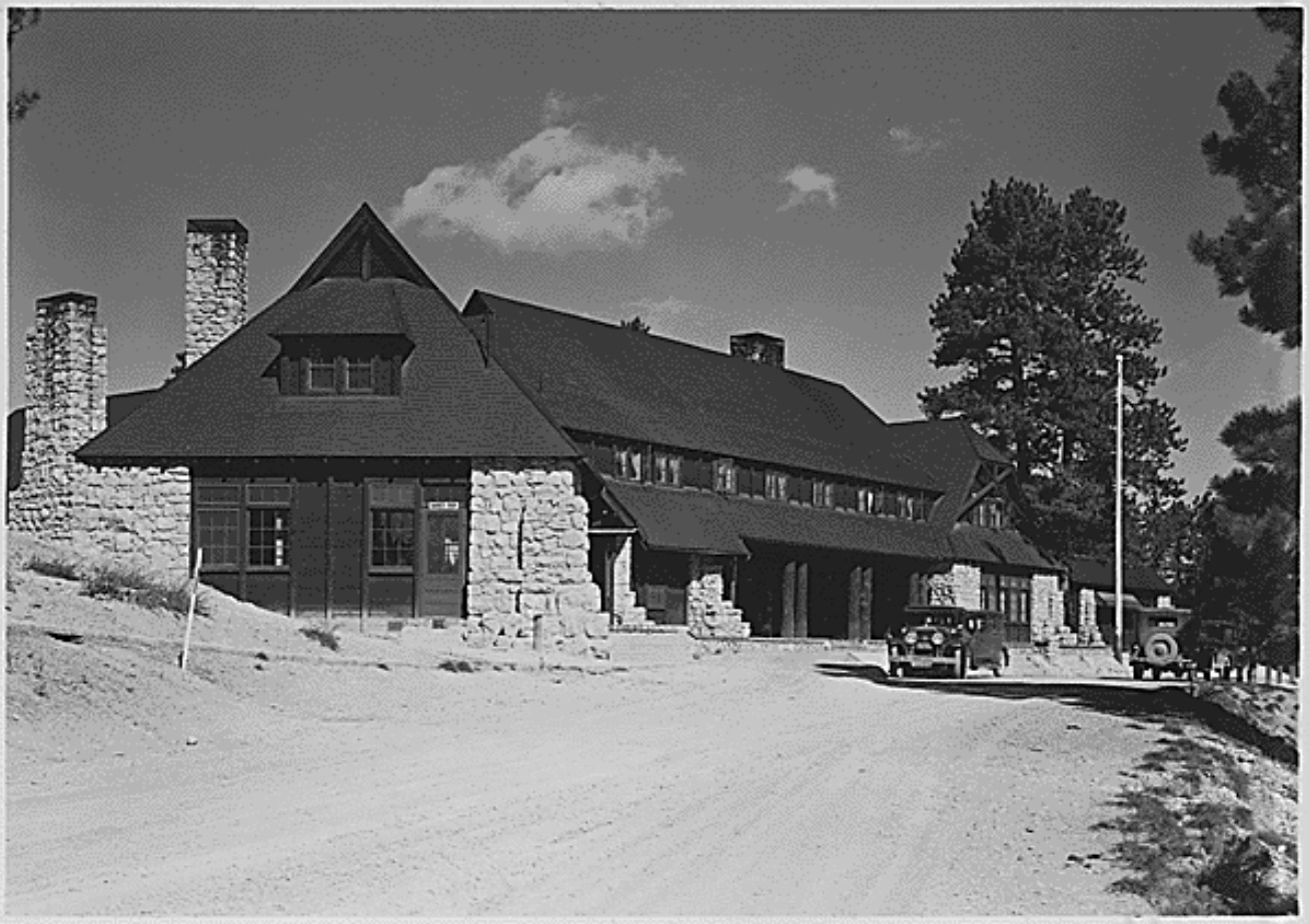
<span style="font-weight:400;">The Utah Parks Company enlisted Gilbert Stanley Underwood, one of the Union Pacific’s consulting architects, to design Bryce Canyon Lodge. Underwood’s designs are notable for their commitment to rustic architecture, which used natural materials and textures to blend a building with its natural surroundings. He utilized locally quarried stone and large, exposed wooden details throughout the structure, figuratively connecting the building to its location. After the company completed the original building in 1925, it added two new wings in 1926 to make room for an increasing number of visitors. The Utah Parks Company constructed fifteen deluxe guest cabins the following year in a pine grove near the main structure. Their design used rough stone and natural wood to imitate the design of Bryce Canyon Lodge. </span>
<span style="font-weight:400;">During the 1950s, the National Park Service renovated Bryce Canyon Lodge to make room for updated amenities. The hotel originally housed a barber shop, but the Park Service replaced it with a soda fountain. The Park Service also enlarged a road at the hotel’s front entrance to make room for larger vehicles, but the Park service expanded a plaza outside Bryce Canyon Lodge’s front entrance by removing the original bus lane in 1989. In 1985, the Park Service removed sixty-one of the lodge’s original sixty-seven standard cabins. The Sunrise Motel and Sunset Motel replaced them. In 1995, the National Register of Historic Places officially listed forty-two buildings in Bryce Canyon, including Bryce Canyon Lodge. This restricted future renovations, allowing the complex to retain most of its architectural significance. Today, Bryce Canyon Lodge operates as a historic hotel alongside five standard cabins and fifteen deluxe cabins. </span></p><p><em><strong><a href="https://www.intermountainhistories.org/items/show/843">For more (including 5 images) view the original article</a></strong></em></p>]]></summary>
    <published>2024-05-29T21:42:39+00:00</published>
    <updated>2026-04-17T19:32:19+00:00</updated>
    <link rel="alternate" type="text/html" href="https://www.intermountainhistories.org/items/show/843"/>
    <id>https://www.intermountainhistories.org/items/show/843</id>
    <author>
      <name>Kaylen Wilson, Northern Arizona University </name>
    </author>
  </entry>
  <entry>
    <title type="html"><![CDATA[Many Glacier Hotel: Glacier National Park ]]></title>
    <summary type="html"><![CDATA[<p><strong><em>After Congress created Glacier National Park in 1910, the Great Northern Railway constructed a complex network of hotels, chalets, roads, trails, and tent camps in the region. The railroad modeled this system after luxury resorts in Europe, and Many Glacier Hotel served as one of its crown jewels.</em></strong></p><img src="https://www.intermountainhistories.org/files/fullsize/2eecb9d891c46a783d81ec6dcc049230.jpg" alt="Many Glacier Hotel, c. 1921" /><br/><p><span style="font-weight:400;">Constructed at the edge of what is now Swiftcurrent Lake, Many Glacier Hotel provided the Great Northern Railway’s second grand hotel at Glacier National Park. It served as the center of the Great Northern’s network of chalets and tent camps alongside the 1910 Glacier Park Hotel. From the grand hotels, tourists could access chalets and tent camps in Glacier’s backcountry. Visitors accessed these locations on horseback, but automobiles later drew tourists away from them. The Great Northern brought an unprecedented level of development into Glacier, and it spent approximately $1.5 million on hotels, chalets, campsites, trails, and roads by 1917. Many Glacier Hotel cost $400,000. </span>
<span style="font-weight:400;">Designed by Great Northern architect Thomas D. McMahon, the hotel comprises three separate buildings connected by covered walkways. The central portion opened in 1915, but the railroad did not complete the hotels’ north and south ends until 1917. Its rough stone siding and foundations resemble the rustic architecture that was becoming increasingly common in national parks. The architect further emphasized this feature in the lobby, which included a grand fireplace and tall wooden support pillars. This imitated the “forest” lobby at Glacier Park Hotel, which uses massive Douglas fir trees as pillars and includes an open fire pit. Many Glacier briefly featured an indoor pool, but the Great Northern removed it due to sanitary issues. </span>
<span style="font-weight:400;">The railroad also intended Many Glacier to match the Great Northern’s other buildings in the park, which imitate Swiss chalets. The hotel’s three sections look like individual Swiss chalets from a distance. Wooden pieces called moldings adorn their windows and balconies, and these pieces feature cutout patterns inspired by the Swiss chalet style. This created a unified sense of place in the region and emulated Glacier’s status as the “Switzerland of North America.” Early advertisements capitalized on this idea during World War I, encouraging guests to “see America first” instead of spending their vacation money to visit foreign locales. The Great Northern hired numerous artists to paint Glacier National Park, and their work hung in train depots and ticket offices. The railroad displayed a variety of paintings from the See America First in Many Glacier Hotel, but only a few remain today. </span>
<span style="font-weight:400;">While Glacier National Park quickly became a popular tourist attraction, the Great Northern’s vast building network became increasingly expensive to maintain. Initially, the railroad kept its resort system to draw train passengers into the park, but it made numerous attempts to sell the hotels as more visitors began to arrive by car. In 1957, the Great Northern hired the Knutson Hotel Company to prepare Glacier’s hotels for sale, and Glacier Park Inc. purchased them in 1960. In 2001, the National Park Service funded a $42 million restoration project that replaced the lodge’s roof and siding, restored original architectural features like balconies, and reinstalled an original circular staircase that the Knutson Hotel Company removed from the hotel lobby in 1957. Xanterra Parks and Resorts currently manages Many Glacier Hotel.</span></p><p><em><strong><a href="https://www.intermountainhistories.org/items/show/842">For more (including 5 images) view the original article</a></strong></em></p>]]></summary>
    <published>2024-05-29T21:10:56+00:00</published>
    <updated>2026-04-17T19:32:19+00:00</updated>
    <link rel="alternate" type="text/html" href="https://www.intermountainhistories.org/items/show/842"/>
    <id>https://www.intermountainhistories.org/items/show/842</id>
    <author>
      <name>Kaylen Wilson, Northern Arizona University</name>
    </author>
  </entry>
  <entry>
    <title type="html"><![CDATA[El Tovar Hotel - Grand Canyon National Park ]]></title>
    <summary type="html"><![CDATA[<p><strong><em>In 1901, the Atchison-Topeka Santa Fe Railway constructed a spur line from Williams, Arizona, that provided access to the Grand Canyon’s South Rim. El Tovar soon followed, providing its guests with the region’s first luxury accommodations.</em></strong></p><img src="https://www.intermountainhistories.org/files/fullsize/4856f91fdf081f933e9854aa688f9055.jpg" alt="El Tovar’s east side, circa 1905" /><br/><p><span style="font-weight:400;">Before the Atchison-Topeka Santa Fe Railway reached Grand Canyon Village in 1901, only a few rudimentary hotels served the Grand Canyon’s South Rim. These establishments relied on a local stagecoach line, which operated between Flagstaff, Arizona and a ranch near the rim. Because the twenty-dollar journey took three days to complete, the railroad provided a more efficient way to reach the canyon, and its arrival shifted the center of activity at Grand Canyon Village away from Thurston’s stagecoach line. Fred Harvey, a hospitality company whose Harvey houses provided quality food and lodging to passengers on the Santa Fe Railway, constructed El Tovar near the railroad tracks to draw in train passengers. The hotel cost $250,000 to construct, providing the Grand Canyon’s first luxury lodgings. </span>
<span style="font-weight:400;">Opened in 1905, El Tovar hotel predated the Grand Canyon’s designation as a national monument in 1908 and a national park in 1919. As a national monument, the Grand Canyon received less funding and attention than established national parks like Yellowstone. However, as tourism increased, calls for the area to receive further protections intensified. Ford Harvey, who served as president of the Harvey company until 1928, routinely advocated for Grand Canyon’s national park status at conferences. Conservation efforts gained strength when Arizona became a state in 1912, but many Grand Canyon residents opposed the national park proposal due to concerns about land and mineral rights. Regardless, President Woodrow Wilson officially signed the bill that established Grand Canyon National Park on February 26, 1919, and the Harvey company secured a hospitality contract from the new National Park Service (created in 1916) in 1920.</span>
<span style="font-weight:400;">Architect Charles Whittlesey’s design for El Tovar used the rustic architectural style, which aimed to establish a connection between buildings and their environment. Whittlesey designed the log siding on the first floor to resemble the wall of a log cabin. Natural building materials like rough stone and logs appear throughout the building, reinforcing this style. Whittlesey combined these rustic features with the architecture of traditional luxury resorts, which catered to Victorian tastes and a desire for exotic destinations. Decorative wooden poles known as balusters, which mimic Swiss chalet architecture, enclose El Tovar’s porches and balconies. The design also includes a small round tower known as a turret, which echoes resort architecture. </span>
<span style="font-weight:400;">El Tovar originally featured luxurious amenities, including hot running water and electric lighting. In the 1950s, the Harvey company added a new cocktail lounge to the hotel’s dining area. A 1983 renovation exchanged the hotel’s sparse public restrooms with private facilities, added carpeting, replaced windows, and included a new heating system. For this reason, El Tovar currently houses seventy-nine rooms instead of the original ninety-five. In 1968, Hawaii-based hospitality company Amfac purchased the Harvey company and gained control of El Tovar. In the 1990s, Amfac created Xanterra Parks and Resorts to control its concessions at the Grand Canyon, and Xanterra still manages El Tovar today. </span></p><p><em><strong><a href="https://www.intermountainhistories.org/items/show/840">For more (including 6 images) view the original article</a></strong></em></p>]]></summary>
    <published>2024-05-29T20:25:01+00:00</published>
    <updated>2026-04-17T19:32:19+00:00</updated>
    <link rel="alternate" type="text/html" href="https://www.intermountainhistories.org/items/show/840"/>
    <id>https://www.intermountainhistories.org/items/show/840</id>
    <author>
      <name>Kaylen Wilson, Northern Arizona University </name>
    </author>
  </entry>
  <entry>
    <title type="html"><![CDATA[Old Faithful Inn - Yellowstone National Park]]></title>
    <summary type="html"><![CDATA[<p><strong><em><span style="font-weight:400;">When the Northern Pacific Railroad’s Upper Geyser Basin Hotel burned to the ground on November 17, 1894, the U.S government pressured the railroad to replace it with new tourist accommodations. The result was Old Faithful Inn, which utilized a new style of architecture to highlight Yellowstone’s iconic landscape. </span></em></strong></p><img src="https://www.intermountainhistories.org/files/fullsize/eddddd6f4d185123b8615299ae39a69b.jpg" alt="Old Faithful Inn, Entrance Drive" /><br/><p><span style="font-weight:400;">On March 1, 1872, President Ulysses S. Grant officially signed Yellowstone into law as America’s first national park. The Yosemite Act of 1864 had restricted settlement in the Yosemite Valley and placed it under the jurisdiction of California’s state government, but the Yellowstone Park Act expanded upon this legislation by designating all of Yellowstone a public park. As a result, the Yellowstone Park Act contained many restrictions on private development and very few administrative procedures to enforce regulations or oversee public use. Poorly supervised independent companies called concessionaires, who paid park administrators a fee to use the land, ran Yellowstone’s public facilities. Only a few concessionaires ferried guests into the park, but the Northern Pacific Railroad quickly expressed interest in Yellowstone’s small tourism industry.</span>
<span style="font-weight:400;">When the Northern Pacific reached Gardiner, Montana, in the early 1880s, its presence provoked interest in Yellowstone’s tourism industry. At this time, only a few concessionaires opened small hotels and tent camps. One such concessionaire, the Yellowstone Park Improvement Company, constructed the Upper Geyser Basin Hotel in 1885 to preserve its failing business. The Northern Pacific purchased its properties in 1885, gaining control of the Upper Geyser Basin Hotel. When fire destroyed it</span><span style="font-weight:400;"> in 1894,</span><span style="font-weight:400;"> the importance of a new hotel in Yellowstone became clear</span><span style="font-weight:400;">. At the time</span><span style="font-weight:400;">, many railroad hotels utilized conventional architectural styles that provided a sense of familiarity for their upper-class audience. The Northern Pacific’s Lake Hotel, constructed in 1890, followed this example. However, </span><span style="font-weight:400;">rustic architecture, which emphasized harmony with the natural environment surrounding a structure, gained popularity in the 1890s. Because distinctive architecture drew more attention from visitors, the Northern Pacific experimented with a rustic style for its new hotel. </span>
<span style="font-weight:400;">The Yellowstone Park Association, a subsidiary of the Northern Pacific, selected Robert Reamer to design its new rustic hotel. The railroad constructed the log building near Yellowstone’s most famous geyser, from which the Old Faithful Inn derived its name. </span><span style="font-weight:400;">The Union Pacific completed the central core of the hotel, known as the “Old House,” in 1903.</span><span style="font-weight:400;"> The finished building was seven stories tall at its highest point, and it cost a total of $140,000 (about $4.9 million today) to construct. The Northern Pacific set aside a further $25,000 (approximately $875,000 today) to furnish the new hotel. Reamer designed his massive log structure to emulate Swiss chalets and Norwegian villas, and he utilized rough, unfinished wood logs obtained in the Park on both the inside and outside of the building to connect it to Yellowstone’s forested landscape. The hotel’s most prominent feature is its seven-story lobby, which features a vast fireplace made of native stone. A complex log frame that supports the hotel’s roof surrounds this room. The structure’s use of exposed wooden supports emphasizes the rustic nature of the lobby, and a series of wooden balconies overlook the main floor of the hotel. </span></p><p><em><strong><a href="https://www.intermountainhistories.org/items/show/839">For more (including 5 images) view the original article</a></strong></em></p>]]></summary>
    <published>2024-05-29T19:43:03+00:00</published>
    <updated>2026-04-17T19:32:19+00:00</updated>
    <link rel="alternate" type="text/html" href="https://www.intermountainhistories.org/items/show/839"/>
    <id>https://www.intermountainhistories.org/items/show/839</id>
    <author>
      <name>Kaylen Wilson, Northern Arizona University</name>
    </author>
  </entry>
  <entry>
    <title type="html"><![CDATA[Sabotage at the Arizona Snow Bowl, 1987]]></title>
    <summary type="html"><![CDATA[<p><strong><em><span style="font-weight:400;">After an eco terrorist fringe organization orchestrated attacks on an Arizona ski resort and power plants throughout the Southwest, FBI undercover agents spent years infiltrating the group.</span></em></strong></p><img src="https://www.intermountainhistories.org/files/fullsize/69a4f22b3aed687abecaee3f9b6eceb4.jpg" alt="Fall Color Scenic Skyride at the Arizona Snowbowl" /><br/><p><span style="font-weight:400;">On the morning of November 7, 1987, members of the eco terrorist group EMETIC carried out an attack on the Fairfield Snow Bowl Ski Resort north of Flagstaff, Arizona. Using propane torches, they cut through cables that supported the main ski lift. The resort was closed in preparation for its winter opening, and the sabotage resulted in no casualties. Snow Bowl officials estimated damages at $26,0000 with an additional $30,000 spent on added security measures. Employees at the Snow Bowl received a computer-generated letter from EMETIC taking credit for the attack. The letter warned to either discontinue ski operations and allow trees to grow back or suffer another sabotage, also referencing that development encroached on sacred indigenous land. On October 25, 1988, a similar attempt occurred. An EMETIC member used a torch to cut through a main support for the cable lift, then called into a local radio station claiming responsibility.</span>
<span style="font-weight:400;">EMETIC (Evan Mecham Eco Terrorist International Conspiracy) was a group comprised of individuals from Prescott, Arizona associated with the </span><span style="font-weight:400;">Earth First!</span><span style="font-weight:400;"> environmental group. The group's name served as a sarcastic reference to right-wing then-governor of Arizona Evan Mecham. Although they had participated in </span><span style="font-weight:400;">EF</span><span style="font-weight:400;">! activities, members of EMETIC believed much more radical direct action was necessary to protect the planet. In 1989, the group plotted to cut electrical transmission lines to nuclear power stations in Arizona, Colorado, and California. On the night of May 30, the FBI arrested three members of EMETIC while they were doing a test run of cutting down a power line tower of the Central Arizona Project canal. Early the next morning, agents arrested </span><span style="font-weight:400;">EF</span><span style="font-weight:400;">! co-founder Dave Foreman in connection to the conspiracy. The FBI indicted a fourth EMETIC member six months later. In 1991, federal courts convicted the ecoterrorists of the attack on the Snow Bowl and planned attacks on the nuclear power plants. Foreman’s charges were separated and later dropped to a misdemeanor, as it was apparent that he was not connected to the ecoterrorist activities.</span>
<span style="font-weight:400;">After the 1987 Snow Bowl incident, the Federal Bureau of Investigation launched THERMCON, an operation to investigate </span><span style="font-weight:400;">Earth First</span><span style="font-weight:400;">! in Arizona. Between 1987 and 1989, undercover agents infiltrated EMETIC and monitored ecoterrorist activity. Ron Fraizer, a friend of the group, worked as a paid informant for the FBI in that time. Agents secretly recorded hundreds of hours of conversations with activists. Following the arrests, </span><span style="font-weight:400;">Earth First</span><span style="font-weight:400;">! members accused the FBI of attempting to undermine their organization by connecting their leaders to extremist activity. </span><span style="font-weight:400;">EF</span><span style="font-weight:400;">! leader Judi Bari alleged that the FBI undercover agents entrapped the members of EMETIC and unsuccessfully tried to convince them to use explosives in sabotage, which agents repeatedly offered to supply. Michael Fain, the undercover agent who infiltrated the group, was allegedly caught on tape saying they needed to bust Dave Foreman to send a message. However, the federal government continued to emphasize the danger of eco terrorist groups and the necessity of operations like THERMCON for national safety.</span></p><p><em><strong><a href="https://www.intermountainhistories.org/items/show/836">For more (including 3 images) view the original article</a></strong></em></p>]]></summary>
    <published>2024-05-27T15:58:41+00:00</published>
    <updated>2026-04-17T19:32:18+00:00</updated>
    <link rel="alternate" type="text/html" href="https://www.intermountainhistories.org/items/show/836"/>
    <id>https://www.intermountainhistories.org/items/show/836</id>
    <author>
      <name>Emily Roth, Northern Arizona University</name>
    </author>
  </entry>
  <entry>
    <title type="html"><![CDATA[Everett Ruess at Veit Springs near Flagstaff, Arizona]]></title>
    <summary type="html"><![CDATA[<p><strong><em>Serving as a homestead and a later rest stop for Everett Ruess' introduction to the Intermountain West as a solo traveler, Veit Springs rests on the side of Arizona's highest mountain, the San Francisco Peaks.</em></strong></p><img src="https://www.intermountainhistories.org/files/fullsize/010f42c0309f906e6329d5c5d348784e.jpg" alt="Everett Ruess with his father and grandfather" /><br/><p>Just north of Flagstaff, Arizona sits in the San Francisco Peaks, or "Dook'o'oosłííd," <em>The Summit that Never Melts</em>, to the Navajo Nationa. In the year 1891, German immigrant Ludwig Veit received a patent for a 160-acre homestead where he and his family constructed a cabin and other structures at what came to be called Veit Springs. Randolph (Pat) Jenks, a student at the Evans Ranch School, a boys preparatory school in Mesa, Arizona, purchased the property from Veit’s relatives in 1930. Jenks, and his classmate Tad Nichols, enjoyed their summers in Flagstaff when the school summered up North. In 1931 the two boys encountered Everett Ruess on his journey through northern Arizona, inviting him to join them back on the homestead. </p><p>Everett Ruess was seventeen when he was picked up near Cameron, Arizona, by Jenks and Nichols. Everett was in bad shape, suffering from his history of anemia and other physical degradation from the desert environment. Tad Nichols, famous photographer of the Colorado Plateau, snapped a photo of Everett and Pat loading his gear, his dog Curly, and Burro Pegasus, into Jenks’ truck before they all set on their way to Jenks’ Deerwater Ranch on the San Francisco Peaks. While Everett was at Veit Springs, he bonded with Jenks over his love for ornithology, the study of birds, and their mutual love for art and the Southwest. Everett created a block print painting and described Jenks’ fascination with his art in a letter home. In fact, Jenks was intrigued enough to purchase one of Everett’s block prints of some native Cliff Dwellings. He enjoyed his new friends and wrote a letter about his “idyllic days” at Deerwater Ranch. Here, Everett escaped the traditional aridness of the Intermountain West and described the environment of the ranch as “cool and bracing” in a letter to his family on June 8th, 1931. Among Everett’s belongings in Davis Gulch was an unsent letter that expressed his “true spirit of delight, exaltation, [and] sense of being more than a man” that he experienced at Veit Springs. </p><p>Everett later traversed the Grand Canyon and resided throughout northeast Arizona, returning home later that year. He set off again to the region in 1932, one of the only years his journey was successfully documented. </p><p>In the 1970s, The United States Forest Service aimed to demolish the cabin Veit hand-built, but the Flagstaff community successfully advocated for its relocation just west of the city's downtown. The Veit Cabin relocation by the Arizona National Guard moved the cabin to its current position within Thorpe Park in Flagstaff, Arizona, just South of Francis Short Pond. Since 1988, the new cabin location has facilitated educational events regarding natural and cultural studies of the landscape. Meanwhile, the cabin’s former site at Veit Springs remains a beautiful spot among the tall aspens on the Veit Springs Hiking Trail where tourists can experience the bracing environment that Everett described, as well as Indigenous petroglyphs and abandoned pumphouses from its early days in history.</p><p><em><strong><a href="https://www.intermountainhistories.org/items/show/829">For more (including 5 images) view the original article</a></strong></em></p>]]></summary>
    <published>2024-05-24T22:33:19+00:00</published>
    <updated>2026-04-17T19:32:18+00:00</updated>
    <link rel="alternate" type="text/html" href="https://www.intermountainhistories.org/items/show/829"/>
    <id>https://www.intermountainhistories.org/items/show/829</id>
    <author>
      <name>Matthew T. Lankton, Northern Arizona University</name>
    </author>
  </entry>
  <entry>
    <title type="html"><![CDATA[North Beach at Bear Lake: The &quot;Caribbean of the Rockies&quot;]]></title>
    <summary type="html"><![CDATA[<p><strong><em>Known as the "Caribbean of the Rockies," North Beach at Bear Lake is remembered for its clear, turquoise waters and the neighboring historical hot springs.</em></strong></p><img src="https://www.intermountainhistories.org/files/fullsize/10473506f86f1e2d1f5ca0c2d8a1af4f.jpg" alt="Bear Lake near Montpelier, Idaho. c. 1898" /><br/><p>The sandy shores of North Beach at Bear Lake meet the turquoise waters that inspired the nickname “Caribbean of the Rockies” and have made the beach a main tourist attraction at the Utah-Idaho border. North Beach sits on Idaho territory and provides activities such as boating, fishing, jet skiing, kayaking, picnicking, sunbathing, and swimming. Paired with these activities are the amenities, which include a boat launch ramp, grills, campgrounds, and picnic tables. In 2022 alone North Beach had over 300,000 visitors as it is a great place for families to come and wade in the shallow, warm waters.</p><p>Bear Lake has 12,000 years of Indigenous history as Native Americans would settle on the beach’s shores and use the waters for fishing and the surrounding areas for plant gathering and hunting. The native tribes that live near North Beach today are the Shoshone and Bannock tribes of southern Idaho. Following the Oregon Trail, Mormon settlers were the next prominent group to live in Bear Lake Valley. They negotiated with the Shoshone tribe for part of the land and established the community of Paris in 1863. Joseph C. Rich was an early pioneer at Bear Lake and married Ann Eliza Hunter. Together they developed the make-shift hot springs at North Beach in 1888 that used an underground pipeline to bring the hot water from the springs to the bathing pools.</p><p>Decades later in 1911, Ethel Bates became the owner of the Grand Hotel built next to the hot springs bath. The hotel became a well-known place to enjoy the scenic views of Bear Lake and allowed visitors to have multiple days at the beach. In 1939, the hotel burned down, leaving only a few pillars and stairs people can visit today. Ruth and Lorenzo Hemmert bought the property in 1950 to rebuild the lodging amenities and renovate the hot spring pools. They owned the property until 2018 when it sold to a land developer who plans to tear down the existing buildings to make room for a subdivision called Lakeview.</p><p>After years of rising popularity, in the late 1960s and early 1970s, there was much conversation about expanding the facilities because of overcrowding. In 1969 the Idaho State Journal noted that about 3,500 persons visited North Beach daily during peak summer days. Construction occurred during the early 1970s and included new campgrounds, restrooms, picnic facilities, and access to running water to mitigate overcrowding and improve sanitation.</p><p>The popularity of North Beach still reigns true and visitors must reserve a spot on the beach, up to one day in advance. Bear Lake and especially North Beach have also been the victim of drought over the past years. Bear Lake Idaho’s brochure notes the “low water levels” and how public use and the exposed lake bed have “created a concern for the lake’s environment and safe recreation use.” Respecting the beach is crucial for a future of sunbathing, swimming, and other beach activities at the “Caribbean of the Rockies.”</p><p><em><strong><a href="https://www.intermountainhistories.org/items/show/828">For more (including 5 images) view the original article</a></strong></em></p>]]></summary>
    <published>2024-05-23T01:05:00+00:00</published>
    <updated>2026-04-17T19:32:18+00:00</updated>
    <link rel="alternate" type="text/html" href="https://www.intermountainhistories.org/items/show/828"/>
    <id>https://www.intermountainhistories.org/items/show/828</id>
    <author>
      <name>Olivia Hall, Northern Arizona University</name>
    </author>
  </entry>
  <entry>
    <title type="html"><![CDATA[Saltair Beach at Great Salt Lake: The &quot;Coney Island of the West&quot; ]]></title>
    <summary type="html"><![CDATA[<p><strong><em>Attracting visitors to float in its salty waters, the southern beaches at Great Salt Lake became increasingly popular with the Saltair Resort but now face environmental threats.</em></strong></p><img src="https://www.intermountainhistories.org/files/fullsize/1dca8d46b480914c5e65caf4b1a71f24.jpg" alt="[Untitled]" /><br/><p>The Great Salt Lakes' southern beach became a well-known vacation spot because of the Saltair Resort and its motto “Try to Sink” which encouraged visitors' curiosity to swim and float in the salty waters. Today, the beach has seen a drop in visitation due to receding water levels, with about 130,000 fewer visitors from 2012 to 2022. At the beach's peak visitation during the late nineteenth century and early twentieth century, beach life consisted of swimming, picnicking, and carnival rides such as a rollercoaster, merry-go-round, and Ferris wheel.</p><p>The Goshute tribe and the Skull Valley Goshutes live near and still use the resources of the southern end of Great Salt Lake. In 1847, Mormon settlers first came to Salt Lake Valley and initiated the recreational beach life on the lake. In the 1860s, Mormon settler Heber Kimball built a ranch near Black Rock Beach. Known later as “Rock House” this spot became the first well-known swimming spot on the lake. Attraction grew with the completion of the Utah Central Railroad in 1870 and the Utah-Nevada Railway in 1875 which made Black Rock and the future Saltair Beach accessible to transcontinental visitors.</p><p>In 1893, Deseret News announced the construction of a new resort called “Saltair.” The Church of Jesus Christ of Latter-day Saints invested the most money in the Saltair Beach Company and hoped to create a wholesome recreational resort that was family-oriented. Saltair opened in 1893 and soon was nicknamed “Coney Island of the West” for its many carnival and recreational attractions. The beaches were most popular on American holidays such as the Fourth of July with thousands of people visiting to swim on weekends and special occasions. In 1919 attendance reached 450,000 people and the resort's popularity peaked during the 1920s. However, on April 22, 1925, Saltair burned down for unknown reasons, and by the 25th, its manager announced rebuilding efforts with no proposed start date. With the promise to be “larger, stronger, and more beautiful” than ever by the Salt Lake Tribune, the second Saltair opened in May of 1926. Nonetheless, the resort did not live up to its predecessor and presently the third Saltair, due to another fire, serves as a concert venue.</p><p>Saltair was the center of beach life at the southern shore of Great Salt Lake, and with the decline of the resort came the decline of beach life. The latest reviews describe the beach as having great views, but decreasing water levels means a long and smelly walk to the water. In 2023 alone the lake lost two feet of water to evaporation and while Utah policymakers and environmental programs have forged a plan to save the lake, they did not include any Native tribes in the conversation. Today, people can still swim, or rather float, in the 12% average salinity levels of the Great Salt Lake compared to the Pacific Ocean's 3.5% average salinity. As well as kayak, boat, and sunbathe on the southern beach's shores and marina.</p><p><em><strong><a href="https://www.intermountainhistories.org/items/show/827">For more (including 5 images) view the original article</a></strong></em></p>]]></summary>
    <published>2024-05-23T00:29:57+00:00</published>
    <updated>2026-04-17T19:32:18+00:00</updated>
    <link rel="alternate" type="text/html" href="https://www.intermountainhistories.org/items/show/827"/>
    <id>https://www.intermountainhistories.org/items/show/827</id>
    <author>
      <name>Olivia Hall, Northern Arizona University</name>
    </author>
  </entry>
</feed>