<?xml version="1.0" encoding="UTF-8"?>
<feed xmlns="http://www.w3.org/2005/Atom">
  <title type="text">Intermountain Histories</title>
  <updated>2026-04-17T19:32:21+00:00</updated>
  <generator uri="http://framework.zend.com" version="1.12.20">Zend_Feed_Writer</generator>
  <link rel="alternate" type="text/html" href="https://www.intermountainhistories.org/"/>
  <link rel="self" type="application/atom+xml" href="https://www.intermountainhistories.org/items/browse?output=rss2"/>
  <id>https://www.intermountainhistories.org/</id>
  <author>
    <name>Intermountain Histories</name>
    <uri>https://www.intermountainhistories.org</uri>
  </author>
  <link rel="hub" href="https://pubsubhubbub.appspot.com/"/>
  <entry>
    <title type="html"><![CDATA[The Donners along the Humboldt River]]></title>
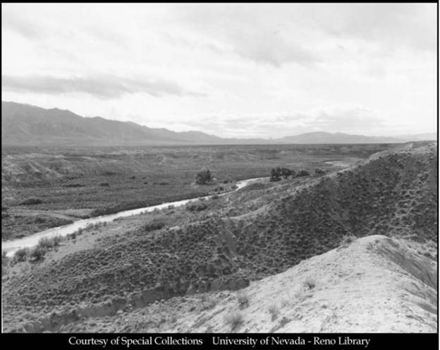
    <summary type="html"><![CDATA[<p><strong><em>The Humboldt River resides in modern-day central Nevada and marks the spot where the Hastings Cutoff reunites with the traditional California trail. It was along this river that distrust overcame the Donner Party, with its party members being attacked, banished, and murdered.</em></strong></p><img src="https://www.intermountainhistories.org/files/fullsize/cd9914b416dc039e95030e789f0a9067.jpg" alt="The Humboldt River" /><br/><p>The Humboldt River was named after German intellectual and explorer Alexander von Humboldt. His name can be found on things such as the Humboldt Ocean Current off the Western coast of South America and Humboldt County in present-day California. The river was used for centuries by Native Americans and became known to non-indigenous populations when Peter Ogden of the British owned Hudson’s Bay Company discovered it on one of his expeditions in 1829. Trappers and mountain men utilized it extensively, and it became a major navigational tool and watering spot for westward migrants in the 1840s. When the late-season and already weakened Donner Party reached the river in mid-September, 1846, drought had lowered the water level and withered adjacent greenery. Their travel along the Hastings Cutoff, which diverged south to skirt around the Ruby Mountains before returning north to the Humboldt River trail intersection, had added 100 miles to what they would have traveled had they stayed on the traditional trail.
Their troubles after the Great Salt Lake Desert were far from over. As they began their journey down the river, progress and supplies were stressed by Paiute depredations on their livestock. Then, on October 5th, as the Murphy family’s wagon led by teamster John Snyder attempted to pass James Reed’s wagon, the two trains became entangled and Snyder whipped Reed’s oxen in anger. Reed retaliated, and in the ensuing scuffle Snyder struck Reed’s wife and Reed stabbed Snyder, killing him. The Graves and Murphy families banished Reed from the group, sending him to the party’s desired destination of Sutter's Fort in California on his horse and promised to care for Mrs. Reed and their young children. Paiute altercations and interpersonal conflicts further escalated problems. An elderly Belgian emigrant, known only as Hardkoop, repeatedly went missing after being kicked out of Lewis Keseberg’s wagon.  An eyewitness said they had seen him sitting alone on the side of the trail unable to continue as <em>“his feet had swollen until the skin had split.”</em> William Eddy attempted to spend resources that night to find him, but was refused by other members of the party. As they progressed alongside the Humboldt River as many as 18 oxen were stolen, one wounded, and 21 killed by Paiutes. Making good progress regardless, they reached Humboldt Sink close to the end of the river, on October 13th. On this day a German emigrant, known only as Wolfinger, stayed behind with two other Germans to cache, or store, his wagon. The two Germans rejoined the party several days later, but Wolfinger was absent. The other Germans claimed Natives had killed him, but one later confessed to murdering Wolfinger, leaving his body to be devoured by vultures and coyotes in the Humboldt Sink.
The party reached the Truckee River which led up into the Sierra Nevada Mountains in eastern California, on the 16th of October. The roughly three week journey along the Humboldt River had strained their relationships and caused them to lose trust in each other. Hardkoop’s abandonment, Reed’s banishment, and Wolfinger’s murder reveal unraveling social cohesion. Losing Reed as a steady leader was especially damaging. The Humboldt served as a refuge from the Great Basin Desert for most emigrant groups heading towards California, but for the Donners it marked exponentially increasing troubles which would remain with them for the rest of their journey. The culmination of all their mistakes, from Forts Laramie and Bridger, the Wasatch Mountain range, the Great Salt Lake Desert, and the Humboldt River, would lead to great suffering for the party in the Sierra Nevadas.</p><p><em><strong><a href="https://www.intermountainhistories.org/items/show/934">For more (including 5 images) view the original article</a></strong></em></p>]]></summary>
    <published>2026-02-02T17:22:15+00:00</published>
    <updated>2026-04-17T19:32:21+00:00</updated>
    <link rel="alternate" type="text/html" href="https://www.intermountainhistories.org/items/show/934"/>
    <id>https://www.intermountainhistories.org/items/show/934</id>
    <author>
      <name>Samuel Watson, Brigham Young University</name>
    </author>
  </entry>
  <entry>
    <title type="html"><![CDATA[Pilot Peak: Looking back at the Great Salt Lake Desert]]></title>
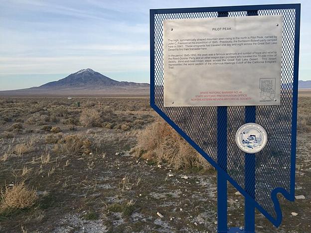
    <summary type="html"><![CDATA[<p><strong><em>Emigrant parties and explorers used this mountain peak on the southern end of Pilot Mountain Range, which straddles the modern Utah-Nevada border west of the Bonneville Salt Flats, as a landmark to track their progress out of the Great Salt Lake Desert. For the Donner Party, the most infamous group of pioneers in American history, it was a place where fatal lost time and resources became realized, and an aura of frantic urgency imbued the party.</em></strong></p><img src="https://www.intermountainhistories.org/files/fullsize/2130a6174f419bcc9a9374aa16511896.jpg" alt="State Historic Marker, Pilot Peak" /><br/><p>By the time the Donners reached Pilot Peak on September 8th, 1846, they had just endured a disastrous eight days of travel from Redlum Spring in Western Utah. It was the last source of freshwater before crossing the salt flats. Lansford Hastings’ directions had insisted it was only <em>“thirty-five miles, or of forty at most”</em> from Redlum Springs to water sources near Pilot Peak. It was, in fact, 80 miles, and Hastings’ promised 2-day itinerary across the parched landscape took the Donner Party eight days in hot, arid conditions.
As they began their trek, Luke Hallaron died of Tuberculosis on August 25th, followed by Franklin Graves having a <em>“fine mare”</em> stolen by the Native Americans, a threat that persisted for the rest of their journey. After cresting an early hill they were greeted by <em>“a perfectly flat plain unbroken even by sage, and dazzling white, like frost, with the glitter of salt.” </em>The hellish landscape’s oppressive heat and lack of shelter drove party members to heat exhaustion. On the second day the hard salt eventually turned into a slushy marshland, where <em>“the wagons broke through the thin crust and sank several inches into sandy slush oozing with salt water”. </em>With the party’s condition quickly deteriorating from dehydration, James Reed rode ahead on the third day and located the springs at the base of Pilot Peak 30 miles away, and returned with what water he could carry. Nine oxen went missing while Reed was gone, having stampeded into the desert at night in search of water, <em>“frenzied and half-blind with thirst.”</em> After returning to his family farther down the trail, they spent a frigid night’s encampment before being awakened by a frenzied ox that charged Reed’s family. Startled, the family pressed forward along Reed’s path in the middle of the night, pushing towards Pilot Peak for the next five days, meeting up with the rest of the party on September 8th.
Like their delay in the Wasatch Mountains, the importance of this slowed pace cannot be understated. The arid desert turned salt marsh entrapped wagons, slowed oxen, and exhausted the already frustrated and delayed emigrants. In addition to adding five days to their planned itinerary, they lost 36 cattle, four wagons, and incalculable energy they crucially needed later. The trail was so difficult that research expeditions in 1929 and 1986 had difficulty and got stuck while re-tracing the party's steps. The delays from crossing the Wasatch Mountains and Great Salt Lake Desert, and the subsequent week-long recuperation at Pilot Peak, put the group over a month behind schedule. Many emigrant parties heading West saw Pilot Peak as a landmark on which to base their progress and pace, but for the Donners’ it represented the beginning of the end. They desperately needed to make up time from their disastrous navigation through the Wasatch Mountains, but the time and resources lost on the Great Salt Lake Desert would prove fatal for almost half of the group.</p><p><em><strong><a href="https://www.intermountainhistories.org/items/show/933">For more (including 6 images) view the original article</a></strong></em></p>]]></summary>
    <published>2026-02-02T17:22:15+00:00</published>
    <updated>2026-04-17T19:32:21+00:00</updated>
    <link rel="alternate" type="text/html" href="https://www.intermountainhistories.org/items/show/933"/>
    <id>https://www.intermountainhistories.org/items/show/933</id>
    <author>
      <name>Samuel Watson, Brigham Young University</name>
    </author>
  </entry>
  <entry>
    <title type="html"><![CDATA[La Concha Lobby/Neon Museum, NV]]></title>
    <summary type="html"><![CDATA[<p><strong><em>A seashell in the Las Vegas sands, the La Concha Hotel is an iconic instance of googie design from the boundary breaking African American Architect Paul Revere Williams</em></strong></p><img src="https://www.intermountainhistories.org/files/fullsize/d7c5abe361196ea8b952fa403af98440.jpg" alt="The La Concha in its original location (Photo between 1980-2006)" /><br/><p>The La Concha Lobby located at 770 Las Vegas Blvd is a striking sight. With its undulating roof swinging in dramatic arches from the ground to delicate apexes and large parabola shaped window panels underneath, the structure resembles more of an organic entity than something fabricated by human hands. Comprised entirely of glass and thin shell concrete, the La Concha embodies its seashell namesake in both color and form. The interior of the lobby is akin to the inside of a dome or a big top tent. The curves of the roof fly high into dome of the interior space and the arched windows fill the white space with light during the day. Hanging lamps illuminate the lobby that now serves as the entry to Las Vegas’ Neon Museum. The space still contains a circular front desk and behind it sits a large decorative plaque of the motel’s distinctive logo and name rendered in sparkling Formica and glass. Originally, the motel had a dramatic neon sign with the same logo posted out front. The sign’s sparkling colors and dramatic neon shapes were right at home with the once plentiful instances of googie design along the Las Vegas strip. Now a multitude of signs are housed behind the La Concha lobby in Las Vegas’ Neon Museum, an archive of the art of hand-blown neon signs that hum their harmonic tone above Sin City.
     Googie architecture is defined by a commitment to futuristic stylism, bright colors, and the highlighting of materials like concrete and neon. Las Vegas became the home of a multitude of googie commercial structures in the mid-century. The famous “Welcome to Fabulous Las Vegas” sign is a piece of googie design, featuring atomic starbursts rendered in bright neon with modern sans serif fonts. The La Concha is a perfect example of googie with its funky shape, bright interior colors, undulating wave forms, and commitment to eye-catching design.
     The man who designed the La Concha Motel was even more remarkable than this striking structure. Paul Revere Williams had been educated at the Los Angeles location of the Beaux Arts Institute and went on to contribute his largest body of work to the American West. He served as architect to the stars of his age, designing houses for Frank Sinatra, Cary Grant, and Desi Arnaz among others. He penned many designs for the Las Vegas cityscape in the mid-century, designing the El Morocco Motel and the Royal Nevada Hotel and Casino, and the Guardian Angel Cathedral. Born in 1894, Williams’ was the first African American man to be admitted into the American Institute of Architects. Its been said that he refined the art of sketching upside down so as to not alienate his white customers by sitting on the same side of the table as them. This speaks to his immense skill as a draftsman and the racial prejudice he lived under. Williams spent his life achieving runaway success in his field while advocating for equality for African Americans.</p><p><em><strong><a href="https://www.intermountainhistories.org/items/show/900">For more (including 3 images) view the original article</a></strong></em></p>]]></summary>
    <published>2025-09-23T15:36:00+00:00</published>
    <updated>2026-04-17T19:32:20+00:00</updated>
    <link rel="alternate" type="text/html" href="https://www.intermountainhistories.org/items/show/900"/>
    <id>https://www.intermountainhistories.org/items/show/900</id>
    <author>
      <name>Emily MacDonell, Northern Arizona University</name>
    </author>
  </entry>
  <entry>
    <title type="html"><![CDATA[The Humboldt River and the Inevitable Railroad]]></title>
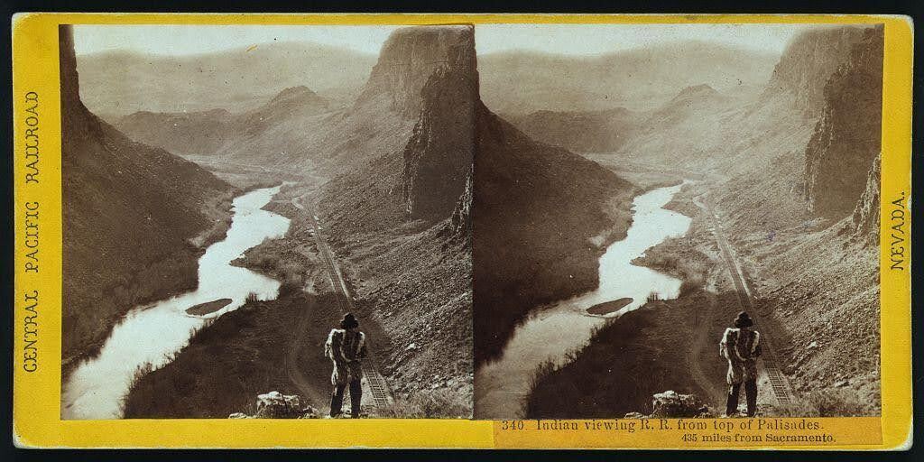
    <summary type="html"><![CDATA[<p><strong><em>Alfred A. Hart’s photo neatly captures the relationship that the United States had with Indigenous nations in the 19th century: persistent encroachment on and abuse of Native land. </em></strong></p><img src="https://www.intermountainhistories.org/files/fullsize/68061ca83529f9dba3c1da8a26419a79.jpg" alt="“Indian viewing railroad from top of Palisades. 435 miles from Sacramento.” " /><br/><p>Winding through the arid region of modern-day north central Nevada, the Humboldt River provided resources to support communities of a few hundred people. Punodungahnivain, or “Place where the house is” in Western Shoshone, was an area at the mouth of the South Fork River, between modern-day Carlin, Elko, and South Fork, that was home to Western Shoshone. </p><p>Water—and therefore the river—is sacred for the Western Shoshone, or “Newe” meaning “The People.” The Humboldt represents an important thoroughfare in ancient and modern trade routes, connecting goods from the Pacific with those in the Great Basin and western Rocky Mountains. The fertile river enabled Indigenous communities to thrive between modern-day Carlin and Elko. Roots and berries grew along the river, attracting birds and animals, and pine nut resources grew in the nearby Ruby mountains. The Shoshones hunted waterfowl, antelope, trout, gopher, rabbit, and beaver. </p><p>Trappers such as Peter Skene Ogden from the Hudson’s Bay Company arrived in the Humboldt region in the 1820s. They trapped as many beavers as possible in order to make it unprofitable for their competition, nearly wiping out the beaver population for a generation. After the discovery of gold at Sutter’s Mill in 1848, miners and settlers traveled along the Humboldt by the tens of thousands, negatively impacting the environment, depleting finite resources, and disrupting Indigenous lifeways. The California Trail transected Western Shoshone Territory throughout the 1840s through 1860s. Then, in the 1860s, the Central Pacific Railroad began building their Railroad from Sacramento, California, westward towards Utah Territory to join with the Union Pacific at Promontory Summit on May 10, 1869. </p><p>By the time CPRR worker Alfred A. Hart took the photo below, dated between 1865 and 1869, natural resources had already been depleted all along the Humboldt. Hart took hundreds of photographs as he traveled with the company, and many of them feature Shoshones. The completion of the railroad brought even more people west, who settled near the tracks in order to benefit from future commerce. These newcomers claimed the most fertile places for themselves and divided up ancestral Shoshone and Paiute lands. </p><p><em><strong><a href="https://www.intermountainhistories.org/items/show/851">For more (including 3 images) view the original article</a></strong></em></p>]]></summary>
    <published>2024-09-25T01:12:50+00:00</published>
    <updated>2026-04-17T19:32:19+00:00</updated>
    <link rel="alternate" type="text/html" href="https://www.intermountainhistories.org/items/show/851"/>
    <id>https://www.intermountainhistories.org/items/show/851</id>
    <author>
      <name>Ella Henricksen, Brigham Young University</name>
    </author>
  </entry>
  <entry>
    <title type="html"><![CDATA[The Abandoned Car Barn of Reno&#039;s Traction Company, Nevada]]></title>
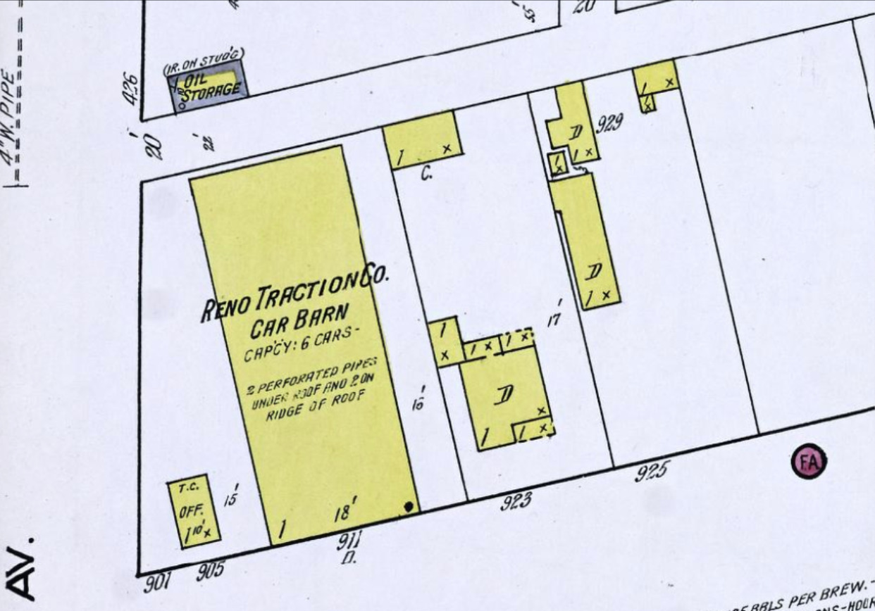
    <summary type="html"><![CDATA[<p><strong><em>Now occupied by an auto parts store and repair shop, the corner of 4th Street and Morrill Avenue was once home to the car barn of Reno’s Traction Company.</em></strong></p><img src="https://www.intermountainhistories.org/files/fullsize/cf3b7d7982b78ac18a7883d08ad9ec48.jpg" alt="Sanborn Fire Insurance Map from Reno, Washoe County, Nevada. Sanborn Map Company, 1918" /><br/><p><span style="font-weight:400;">On the I-80 Business Loop at East 4th Street, just east of downtown Reno, Nevada, there is an auto repair shop, offering transmission service and selling tires. In the early 20th century, however, this city block served as the location of a holding facility belonging to the Reno Traction Company, which operated cars on Reno’s once expansive streetcar network.</span>
<span style="font-weight:400;">Founded in 1868, the western Nevada city of Reno had undergone explosive growth in the late 19th century. By 1900, its boom in population and urban density spurred the establishment of communities on its outskirts, including Sparks to Reno’s immediate east. With the metropolitan area rapidly expanding, the necessity of a quick and easy commute within Reno and to its extremities became clear. In 1904, a group of local businessmen organized the Nevada Transit Company, which set to work on building the state’s first electric streetcar line, a three mile leg running between the Southern Pacific rail yards in Reno and Sparks respectively.</span>
<span style="font-weight:400;">The line opened on Thanksgiving Day 1904 after a construction period of four months. It was an immediate hit with Reno’s citizens, who packed the cars to make the half-hour journey for a fare of ten cents. With the trolley’s popularity, especially among working-class commuters and pleasure seekers headed to the amusement park at Asylum Crossing, the Nevada Transit Company began working on expansions, notably across the Virginia Street Bridge in 1905. The Company constructed a barn on East 4th Street to house its trolley cars, which became a focal point of the network.</span>
<span style="font-weight:400;">In 1906, the Reno Traction Company purchased the Nevada Transit Company’s assets. It continued to improve the burgeoning streetcar network and expand it across the city. New lines provided service north to the University of Nevada campus, while a separate company, the Nevada Interurban, ran cars southward to the Moana Springs resort. These expansions not only allowed for ease of transport across the Reno metropolitan area, but also facilitated the development of new communities along the trolley tracks. Of all the lines operated by both companies, the Reno-Sparks connection remained the most popular, hosting 80% of the system’s ridership.</span>
<span style="font-weight:400;">However, in the 1910s, the system found itself increasingly unable to compete with the rising popularity of automobiles. Encumbered as well by rising maintenance costs, the streetcar companies began reducing service and shutting down lines. By 1919, the Nevada Interurban had disbanded, and the Reno Traction Company closed service on all intra-city routes. The Reno-Sparks line remained open, but starting on June 15, 1927, it faced competition for passengers from the newly commissioned intercity bus line. Finally, in September of that year, the Reno Traction Company ended operations on the Reno-Sparks line, bringing Reno’s three decades with its streetcar to an end. The Company decommissioned and sold all of its trolley cars. The city tore down the car barn on 4th Street, and an auto parts and repair shop replaced it. The car barn was usurped by the very cars that had run its builders out of business.</span></p><p><em><strong><a href="https://www.intermountainhistories.org/items/show/817">For more (including 3 images) view the original article</a></strong></em></p>]]></summary>
    <published>2024-05-21T05:07:29+00:00</published>
    <updated>2026-04-17T19:32:18+00:00</updated>
    <link rel="alternate" type="text/html" href="https://www.intermountainhistories.org/items/show/817"/>
    <id>https://www.intermountainhistories.org/items/show/817</id>
    <author>
      <name>Liam Craddock, Northern Arizona University </name>
    </author>
  </entry>
  <entry>
    <title type="html"><![CDATA[Wendover Will]]></title>
    <summary type="html"><![CDATA[<p><strong><em>The Wendover Will mechanical cowboy stands as an iconic landmark of Wendover, Nevada. Wendover Will’s construction was a feat of advanced mechanical engineering for the time, and represents the lengths Americans were willing to go to in order to drive tourism, business, and growth to small western towns in the early-to-mid-20th century.</em></strong></p><img src="https://www.intermountainhistories.org/files/fullsize/27278f4a0e6c58a666a7517646bbcd83.jpg" alt="Wendover Will " /><br/><p><span style="font-weight:400;">The city of Wendover, Nevada sits on the border of Utah and Nevada. It houses the Wendover airfield, home to many World War II relics. Wendover also lies next to the Bonneville Salt Flats, a popular camping site for many Utahns and Nevadans. However, none of these sites are quite as eye-catching as the 63-feet-tall neon cowboy that rises over the city. “Wendover Will,” dubbed the World’s Largest Mechanical Cowboy, was named after</span> <span style="font-weight:400;">Mr. William “Bill” Smith, the founder of the city. In 1926 he established a service station in the area to help travelers on what is now the I-80. His meager establishment grew into a thriving gambling city when the city of Wendover was founded in July 1991. </span>
<span style="font-weight:400;">One of the early landmarks in Wendover was a large electric pole similar to those in Las Vegas. A light flashed on top of the pole to alert travelers to the presence of Smith’s service station. The electric pole remained a signature feature of the town as it grew from a service station meant to serve passersby to a town full of hotels, casinos, and cafes. Due to Wendover’s rapid expansion, the residents of the town felt they needed a fun attraction besides the casinos to encourage tourism. In 1951, construction began on the electric light pole as the Young Electric Sign Company converted it into Wendover Will. The company completed construction of Wendover Will in the spring of 1952, which was no small feat and included Will’s height at 63-feet-tall, a large cowboy hat, a gun in his holster, and a cigarette in his mouth. One enormous hand points to the town while the other beckons to the approaching freeway travelers. Both arms are powered by a ¾ motor and the monument has 1,184 feet of neon lights and tubing that enable it to be seen from miles away. For a monument created in 1952, this was ahead of its time in mechanical engineering. </span>
<span style="font-weight:400;"> Wendover Will made history in the “Guinness Book of World Records” as the “Largest Mechanical Cowboy in the Entire World, ” beating his rival, Vegas Vic, a similar neon cowboy on the Las Vegas strip. Wendover Will continues to appeal to the people on the Nevada-Utah border, welcoming all who travel through along I-80.</span></p><p><em><strong><a href="https://www.intermountainhistories.org/items/show/737">For more (including 3 images) view the original article</a></strong></em></p>]]></summary>
    <published>2023-04-06T17:30:50+00:00</published>
    <updated>2026-04-17T19:32:16+00:00</updated>
    <link rel="alternate" type="text/html" href="https://www.intermountainhistories.org/items/show/737"/>
    <id>https://www.intermountainhistories.org/items/show/737</id>
    <author>
      <name>Isaac Rex, Brigham Young University</name>
    </author>
  </entry>
  <entry>
    <title type="html"><![CDATA[Anti-Chinese Riot in Tonopah, Nevada]]></title>
    <summary type="html"><![CDATA[<p><strong><em>Because of anti-Chinese attitudes in central Nevada, a mob of white union workers attacked Tonopah’s Chinatown in September of 1903. One Chinese man was killed and several others were injured, and Chinatown was destroyed. </em></strong></p><img src="https://www.intermountainhistories.org/files/fullsize/5db119f1bcc036387ec509da0fea5311.jpg" alt="Laundromat in Tonopah " /><br/><p><span style="font-weight:400;">Tonopah, Nevada is a small town in central Nevada that popped up in 1900 when silver was discovered in the area. Within a few years, the mining town was booming, and many Chinese immigrants, mainly men, moved to Tonopah seeking opportunity. The Chinese, however, were not actually allowed to mine in this part of Nevada, so they took up jobs as laundrymen and cooks. Although their labor was needed, white miners were still apprehensive about Chinese immigrants in town, and national anti-Chinese laws and broad anti-Chinese sentiment in the Western United States fomented resistance to their presence. Whereas many other outbursts of anti-Chinese violence in the west began when Chinese miners were hired to undercut unionized white miners, the Chinese population targeted in Tonopah were not hired to undercut potential strikes.</span>
<span style="font-weight:400;">On September 15, 1903, a group of about 30-50 white labor union members marched into Tonopah’s Chinatown and demanded the Chinese immigrants living there to leave in the next 24 hours. Later that day, a second, larger group of men came to Chinatown and began destroying the homes and businesses of the Chinese people. The mob burned down over 100 Chinese establishments and was responsible for the death of 66-year-old Chong Bing Long, who owned a laundromat in town and had lived in the United States for over 30 years. Long was not fast enough to escape the men in the mob, who robbed and beat him. They then drove him outside of town to the desert, where they beat him again and left him to die. Though this was the only death, several Chinese people received serious injuries from being beaten, with little being done by local police to protect them. </span>
<span style="font-weight:400;">In the aftermath, the Chinese returned to town to assess the damage. Fifteen white men were initially arrested for their involvement in the riot, but nine were immediately released and the other six were acquitted of all charges. The Chinese pulled all of their resources together to pay to convict members in the mob, but eventually ran out of money and had to stop pursuing the case.  The Chinese embassy tried to help, but was largely powerless. Many of the Chinese chose to stay in Tonopah, and several white locals told the Chinese they would, “work out a plan to provide protection” for them. Others left for nearby cities like Reno, and resentment for the Chinese gradually died down in Nevada over the next few years.</span></p><p><em><strong><a href="https://www.intermountainhistories.org/items/show/730">For more (including 6 images) view the original article</a></strong></em></p>]]></summary>
    <published>2023-03-06T22:40:44+00:00</published>
    <updated>2026-04-17T19:32:16+00:00</updated>
    <link rel="alternate" type="text/html" href="https://www.intermountainhistories.org/items/show/730"/>
    <id>https://www.intermountainhistories.org/items/show/730</id>
    <author>
      <name>Sydney Wilson, Brigham Young University</name>
    </author>
  </entry>
  <entry>
    <title type="html"><![CDATA[Anti-Chinese Riot near Virginia City, Nevada]]></title>
    <summary type="html"><![CDATA[<p><strong><em>In 1869, with anti-Chinese sentiment growing in the west, a mob in Virginia City, Nevada attempted to expel the Chinese immigrants from town. They raided the railroad where the Chinese were laying tracks, demanded their departure, and destroyed all of their property. </em></strong></p><img src="https://www.intermountainhistories.org/files/fullsize/b8f3b7605935f2ffe65447f76de43fe6.jpg" alt="Three Chinese Women and a Chinese Boy in Virginia City" /><br/><p><span style="font-weight:400;">In the latter half of the nineteenth century, thousands of people, including many immigrants, flocked to the Intermountain West region in search of economic opportunity. Virginia City, Nevada was a popular destination for these laborers due to its booming silver mining industry. The city sprung up in the late 1850s, and by the late 1860s, it was the largest mining town in Nevada. Most who migrated to Virginia City were of European descent, but the town also attracted many Chinese laborers. As was common in other parts of the country, the Chinese in Virginia City were willing to work for lower wages than other ethnic groups. This increased the competitiveness of the labor market in Virginia City and turned other groups against the Chinese community. </span>
<span style="font-weight:400;">In 1869, anti-Chinese sentiment was running high in Virginia City, and the unionized miners in the city decided to act against the Chinese laborers working on grading the Virginia and Truckee Railroad. On September 29th, a mob of nearly 400 men marched on the Chinese. Sensing trouble, Sheriff W. J. Cummings followed the mob and tried to stop them, but he was powerless against the mass of angered miners. When the mob arrived at the tracks, they demanded that the Chinese depart within thirty minutes and began destroying their property and makeshift residences. Luckily, no Chinese people were injured by the mob, but the property destruction was extensive. </span>
<span style="font-weight:400;">A week later, William Sharon, a railroad official, met with the leaders of the mob and came to an agreement with two provisions: first, the railroad would stop employing Chinese workers; and second, the mob would stop harassing the Chinese. Sharon was reluctant to enter into this agreement because he could employ Chinese laborers at a better rate than white laborers, but the mob could not be reasoned with. They simply wanted the Chinese gone. </span>
<span style="font-weight:400;">Local newspapers condemned the actions of the mob and called for those involved to be arrested; however, they knew it would be extremely difficult to find a jury who would convict the mob members. Indeed, no action was taken against any of the mob participants. By October 21st, the railroad only employed workers of European descent. Many of the Chinese people did leave town, but others found various forms of employment in the city. Chinese people faced continual discrimination in Virginia City, but they continued to find work and ways to send money back to their families in China and make a life in the country.</span></p><p><em><strong><a href="https://www.intermountainhistories.org/items/show/729">For more (including 6 images) view the original article</a></strong></em></p>]]></summary>
    <published>2023-03-06T22:17:52+00:00</published>
    <updated>2026-04-17T19:32:16+00:00</updated>
    <link rel="alternate" type="text/html" href="https://www.intermountainhistories.org/items/show/729"/>
    <id>https://www.intermountainhistories.org/items/show/729</id>
    <author>
      <name>Sydney Wilson, Brigham Young University</name>
    </author>
  </entry>
  <entry>
    <title type="html"><![CDATA[Fish Creek Massacre]]></title>
    <summary type="html"><![CDATA[<p><strong><em>In the summer of 1869, Italian immigrants in Eureka, Nevada decided to go on strike to protest low wages. Local tensions escalated the situation to the point of violence, and, on August 18, 1879, five protesting Italian immigrants were killed. </p></strong></p><img src="https://www.intermountainhistories.org/files/fullsize/ecef27111ebdf406b0daf3a633e5fe8b.jpg" alt="Ore Shutes in Eureka" /><br/><p><span style="font-weight:400;">In the 1870s, Eureka was the second largest mining town in Nevada. Eureka produced primarily charcoal, and many flocked there as new smelters increased labor demands. As was the case in many other booming western mining towns, immigrants made up a large portion of the population. Italians were by far the largest immigrant group in Eureka. Racial and cultural prejudice against Italians that was prevalent throughout the United States was mirrored in Eureka and other western mining towns. As a result, they were paid less than half of what the average miner made. On July 6, 1879, a large group of mainly Italian coal burners gathered at a local saloon to unionize. They formed the Eureka Charcoal Burners Protective Association with the goal of increasing wages. Since Italians made up the majority of Eureka’s cheap labor force, the group's resulting labor strike halted charcoal production. </span>
<span style="font-weight:400;">With a dwindling charcoal supply, tensions in town grew. Eventually, Sheriff Matthew Kyle began arresting some of the strike’s ringleaders. Further, because he did not want to involve state militia, he created a “fighting posse” to go to the charcoal camps and arrest the strike leaders.  They did so over the next month, but on August 18, 1879, the posse turned violent.</span>
<span style="font-weight:400;">The posse of about 20 men set out for Fish Creek, where a large group of strikers was rumored to be camped.  Despite being extremely outnumbered by the striking laborers, deputies attempted to arrest the strike leader. When strikers resisted and the posse was unable to make their arrest, tempers flared. Marshall Rich, one of the head deputies, started insulting the Italian leader, who pulled out his gun and fired at Rich. The posse then opened fire on the mostly unarmed coal burners. Five Italians were killed in the massacre, six were seriously injured, and fourteen were sent to prison. Those who died were all Italian and included: Giovanni Pedroni, Marcellus Locatelli, Todoro Zesta, Pompeo Pattini, and Anotonio Canonica.  </span>
<span style="font-weight:400;">Other accounts of the massacre vary, with some placing all of the blame on the posse and others claiming that the Italians were seeking violence. Regardless, the posse ceased making arrests after this and no one in the posse was charged. The strike eventually ended, and tensions between the Italians and other groups lessened in the following years. </span></p><p><em><strong><a href="https://www.intermountainhistories.org/items/show/727">For more (including 6 images) view the original article</a></strong></em></p>]]></summary>
    <published>2023-03-06T21:27:00+00:00</published>
    <updated>2026-04-17T19:32:16+00:00</updated>
    <link rel="alternate" type="text/html" href="https://www.intermountainhistories.org/items/show/727"/>
    <id>https://www.intermountainhistories.org/items/show/727</id>
    <author>
      <name>Sydney Wilson, Brigham Young University </name>
    </author>
  </entry>
  <entry>
    <title type="html"><![CDATA[Cattle Round-Up Mural: Winnemucca, Nevada]]></title>
    <summary type="html"><![CDATA[<p><strong><em>The Treasury Section of Fine Arts financed Polly Duncan to paint Cattle Round-Up in the Winnemucca Main Post Office as a part of its 1940 expansion plan. It is a model example of the regionally focused murals completed as a part of the New Deal’s Federal Art Project, and can now be found in the new Winnemucca Post Office on Hanson Street.   </em></strong></p><img src="https://www.intermountainhistories.org/files/fullsize/fcf3a160fc91d54cd57acb409f85430a.jpg" alt="&quot;Cattle Round-Up&quot; by Polly Duncan" /><br/><p><span style="font-weight:400;">Polly Duncan’s </span><i><span style="font-weight:400;">Cattle Round-Up</span></i><span style="font-weight:400;">, added to the Winnemucca Main Post Office as a part of its </span><span style="font-weight:400;">1940 renovation project, provides a model example of the New Deal’s Federal Art Project and its goals. Constructed in 1921 by James A. Wetmore, the Neo-Classical Winnemucca Main Post Office was the original home of </span><i><span style="font-weight:400;">Cattle Round-Up</span></i><span style="font-weight:400;"> and was the first federally constructed post office in the northern Nevada town. Today, </span><i><span style="font-weight:400;">Cattle Round-Up</span></i><span style="font-weight:400;"> can be viewed in the city’s new post office building located on Hanson Street.     </span>
<span style="font-weight:400;">Polly Duncan, a Denver-based artist, completed the mural in 1942 under the Federal Works Agency Section of Fine Arts. Duncan worked in the 1930s under the mentorship of established Coloradan muralist Frank Mechau, who highlighted the beauty of natural western landscapes in his works. Accompanied by a collective of other young artists, she lived in a cottage located in Redstone, Colorado. She assisted Mechau on his own artistic endeavors during the winter of 1936. </span>
<span style="font-weight:400;">Only one of three WPA murals in Nevada, the oil-on-canvas work depicts several cowboys in the foreground as they herd Hereford cows into a shed. In the background, the rest of the herd can be seen against the backdrop of the Nevada landscape with its expansive fields, reflecting the area’s significant local history in cattle ranching. </span>
<span style="font-weight:400;">Emigrants first brought the cattle into the area during the 1840s on the Applegate and California trails, where groups founded cattle ranches in the 1850s. The vastness of the Humboldt River Valley landscape, with plenty of space for grazing, made the area a desirable location to raise cattle, and by the 1870s, the industry was thriving with the help of the Central Pacific Railroad’s shipping capabilities. The Hereford cattle depicted in Duncan’s mural were a particularly popular choice of livestock in 1890s Winnemucca for their faster maturation, which in turn enabled greater profits.   </span>
<span style="font-weight:400;">The mural is a common example of the type of artwork produced under the Section of Fine </span><span style="font-weight:400;">Arts-Federal Works Agency and represented the federal government’s goal to provide aid to local communities through employing artists to depict optimistic American images. Indeed, the New Deal-era murals did not typically portray the Great Depression’s difficulties or create generalized images of a geographic American identity. Rather, they often represented local communities. As such, the mural reflects the goals of building American cultural identity in the Intermountain West and democratizing American art as everyday people were able to interact with the image on their regular visits to the post office.  </span></p><p><em><strong><a href="https://www.intermountainhistories.org/items/show/713">For more (including 6 images) view the original article</a></strong></em></p>]]></summary>
    <published>2023-02-25T01:45:12+00:00</published>
    <updated>2026-04-17T19:32:15+00:00</updated>
    <link rel="alternate" type="text/html" href="https://www.intermountainhistories.org/items/show/713"/>
    <id>https://www.intermountainhistories.org/items/show/713</id>
    <author>
      <name>Lindsey Cillis, Northern Arizona University</name>
    </author>
  </entry>
  <entry>
    <title type="html"><![CDATA[Piper’s Opera House and the Virginia Benevolent Association]]></title>
    <summary type="html"><![CDATA[<p><strong><em>This historic venue in Virginia City, Nevada offered a space for women during the early nineteenth century to express their creativity. Whether it was public plays or private theatrics, the auditorium was a place where women could escape daily life and participate in meetings dedicated to their unique interests with friends.</em></strong></p><img src="https://www.intermountainhistories.org/files/fullsize/494df09b46e1da0a2bc49152b8f0e09c.jpg" alt="Piper’s auditorium" /><br/><p>The building that currently sits on B Street in Virginia City, Nevada is the third iteration of Piper’s Opera House. Wealthy entrepreneur John Piper financed the city’s first opera house in 1863, but the structure burned to the ground in the Great Fire of 1875. Three years later in 1878, Piper funded construction for a new opera house on the same land, yet it also burned down in 1883. To raise money for yet another opera house, Piper rented Cooper Hall and began presenting various entertainments within only days after the 1883 fire. Piper’s (third) Opera House opened its doors on March 6, 1885, and John Piper organized a town dance on the same day to celebrate its completion.
This final version of Piper’s Opera House, built into the eastern slope of Mount Davidson, has a stone foundation and masonry façade with wooden shiplap siding and asymmetrical arched windows. Inside is an auditorium smaller than a full basketball court, a sloped stage which makes the entire area visible from any seat, a box office, and Piper’s private apartment. Colorful and textured wallpapers adorn the auditorium interior, and wooden flooring runs throughout. The opera house still bears its original sign, featured above the entrance doors. In its early history, the building served as a performing venue, meeting ground, and training facility for boxers.
Piper’s three Opera Houses also provided acceptable public forums for women to participate in amateur and professional theater. The Virginia Benevolent Association produced a concert in 1875 to raise funds to help the poor prepare for winter. Club women provided much of the entertainment. Members recited from <em>Hiawatha</em>, sang “Good Night My Sweet,” and played the hornpipe. One club affiliate reminisced that the opera house provided an outlet for women to express themselves in a safe space, whether in public or privately among a few women. Piper’s Opera House was an essential location for Virginia City’s women to discover and develop creative expression.
The Virginia Benevolent Association disbanded in the early-twentieth century, but Piper’s Opera House still hosts events today. Theater production is ongoing, and Piper’s is also a popular venue for local events like weddings, ceremonies, birthdays, and holidays. Preservationists secured the opera house a place on the National Register of Historic Places in 1997.</p><p><em><strong><a href="https://www.intermountainhistories.org/items/show/607">For more (including 5 images) view the original article</a></strong></em></p>]]></summary>
    <published>2022-06-10T20:15:56+00:00</published>
    <updated>2026-04-17T19:32:13+00:00</updated>
    <link rel="alternate" type="text/html" href="https://www.intermountainhistories.org/items/show/607"/>
    <id>https://www.intermountainhistories.org/items/show/607</id>
    <author>
      <name>Amy Megowan, Northern Arizona University</name>
    </author>
  </entry>
  <entry>
    <title type="html"><![CDATA[Belknap House]]></title>
    <summary type="html"><![CDATA[<p><strong><em>Built by a state assemblyman and later owned by the Chief Justice of the Nevada Supreme Court, the Belknap House is a well-preserved example of Second Empire architecture in Nevada.</em></strong></p><img src="https://www.intermountainhistories.org/files/fullsize/8f532b5613bce46ffa99ef4f4c67384c.jpg" alt="Belknap House, facing North Street" /><br/><p>Constructed during Carson City’s heyday by state assemblyman Henry Hudson Beck in 1875, the Belknap House remains a well-preserved instance of the Second Empire style. Its distinguishing mansard roof, which curves downward from its flat top on four sides, includes two arched windows on each side, creating a more refined appearance, while also yielding additional light and living space in the second story. The exterior embraces decoration, particularly on the porch with ornamentation above the posts, alongside the motifs running above its first-story windows, called gingerbread. The bay windows facing John Street give the house greater dimension and character and provide more natural light. Most Second Empire homes are built with brick, but Beck went for the more economical wooden siding, giving the building a distinctive appearance in comparison to other residences of the same era. In 1876, only a year after finishing the house, Beck moved to Reno, looking to fund the creation of a new sawmill, and he lived there until his death.
Oscar Barber purchased the property, lived there until 1881, and sold it to Charles Belknap, a five-term Justice of the Nevada Supreme Court and former Mayor of Virginia City. Around 1890, Belknap opted to construct a single-story addition onto the western façade, adding an extra dining and living room. He also matched Beck’s exterior designs, particularly the inclusion of a look-alike porch for the second entryway. However, Belknap decided to top the add-on with a gable roof, which slops on two sides leaving a gable (the wall) in between the roof’s sides. This design decision indicates the fashionable shift towards other architectural styles in the 1890s, as Second Empire gradually became outdated. Belknap retired from the Supreme Court in 1905 and subsequently moved to the California coast, where he died in 1926.
The residence is substantial at 2,600 square feet, containing three bedrooms and two bathrooms. It went through other expansions after Belknap’s ownership, including two garages built around 1920 and 1954. Interestingly, the house also contains a 1960s-era nuclear fallout shelter, now used as a guest house. It is the only privately-held fallout shelter in Carson City. None of these additions, however, contribute to the historical significance of the site, according to the National Register of Historic Places, as they fall outside the boundaries of the original home and additions. As one of the few examples of Second Empire architecture in Carson City, the Belknap House holds a special place in Carson City’s local history and western American Architecture. Its owners successfully added it to the National Register of Historic Places in 1997. At the time of writing, it is not open to the public for visitors.</p><p><em><strong><a href="https://www.intermountainhistories.org/items/show/594">For more (including 6 images) view the original article</a></strong></em></p>]]></summary>
    <published>2022-04-16T04:21:35+00:00</published>
    <updated>2026-04-17T19:32:12+00:00</updated>
    <link rel="alternate" type="text/html" href="https://www.intermountainhistories.org/items/show/594"/>
    <id>https://www.intermountainhistories.org/items/show/594</id>
    <author>
      <name>William R. Batson, Northern Arizona University</name>
    </author>
  </entry>
  <entry>
    <title type="html"><![CDATA[Desert National Wildlife Refuge and the Nuwu (Paiute)]]></title>
    <summary type="html"><![CDATA[<p><strong><em>Franklin D. Roosevelt ordered the creation of a wildlife refuge that protects indigenous interests to this day. The Nuwu have deep roots in the land and wildlife.</em></strong></p><img src="https://www.intermountainhistories.org/files/fullsize/67316c1bf67beb12e1b4428a319d2fe2.jpg" alt="Desert National Wildlife" /><br/><p>Desert National Wildlife Refuge is the largest wildlife refuge in the continental United States, spreading over 1.6 million acres of land and six different mountain ranges in Southern Nevada within the Clark, Lincoln, and Nye Counties. President Franklin D. Roosevelt created the refuge by executive order in 1936, and at that time federal protection spanned the entirety of the current Desert National Wildlife Refuge, Mount Charleston, and much of today’s Red Rock National Recreation Area. The need for protection stemmed from the steeply declining population of native plants and animals, specifically desert bighorn sheep.
Desert National Wildlife Refuge includes lands sacred to the Nuwu, also known as the Southern Paiutes. The land is the setting of Nuwu origin stories and legends as well as the lands their people lived in and thrived upon for many generations. Artifacts of the Paiutes are scattered across the land and are sacred to local Paiute communities. Greg Anderson, Chairman of the Moapa Band of Paiutes says, “We honor these gifts through the many songs we sing that talk about the natural landscape that bestows food, medicine, wildlife, water and the air we breathe. We connect to the loves, joys and struggles of our many ancestors who were here long before us.” They still practice Nuwu traditions tied to the land, which makes preserving it important to keeping traditions alive.
The Desert National Wildlife Refuge is also important to the Nuwu people because it is the natural habitat of the desert bighorn sheep, or <em>nah’gah</em> to use the Paiute name. The nah’gah were one of the Nuwu’s main food sources. Paiute legends tell how their people were starving and the desert bighorn sheep stepped forward and sacrificed their lives so the people could survive. Nuwu view the nah’gah as protectors of their people include giving them power and energy and guiding them through drought and disease. The Nuwu strive to protect the desert bighorn sheep because they believe their people are tied to them and if they die then the Nuwu people will die as well. To this day, the Nuwu honor the nah’gah through stories, songs, and dances.</p><p><em><strong><a href="https://www.intermountainhistories.org/items/show/589">For more (including 3 images) view the original article</a></strong></em></p>]]></summary>
    <published>2022-04-09T19:28:49+00:00</published>
    <updated>2026-04-17T19:32:12+00:00</updated>
    <link rel="alternate" type="text/html" href="https://www.intermountainhistories.org/items/show/589"/>
    <id>https://www.intermountainhistories.org/items/show/589</id>
    <author>
      <name>Amanda Reece, Brigham Young University</name>
    </author>
  </entry>
  <entry>
    <title type="html"><![CDATA[Fremont Theatre]]></title>
    <summary type="html"><![CDATA[<p><strong><em>From hosting the premiere of the 1960 American classic <em>Ocean’s Eleven</em>, to standing against racial discrimination, the history of the Fremont Theatre is a lost treasure in the Las Vegas desert.</em></strong></p><img src="https://www.intermountainhistories.org/files/fullsize/faf1a3d4f220e9826b159120efba04fc.jpg" alt="Marquee" /><br/><p>The Fremont Theatre was located inside a hotel of the same name in Las Vegas, Nevada in the 1930s. It was one of the only theaters in town, but visitor attendance was not high enough to keep the Fremont active during the Great Depression period, so it soon fell into disrepair. Irene Dunne, an old film actress, purchased the Fremont, Huntridge, and Guild Theatres and leased them to Gertrude Sperling in 1951. Sperling acquired the theaters as a business endeavor following her divorce, but she quickly found herself out of her depth. For help, she reached out to her daughter and son-in-law, Edythe and Lloyd Katz.
Lloyd had a background in the film industry, having worked for several motion picture companies throughout California and Arizona as a film distributor and was well respected in the business. When his mother-in-law signed a twenty-seven-year lease on the Vegas theaters, Lloyd was head of the Eagle-Lion motion picture company in San Francisco. The Katzes agreed to take over the running the theaters, and they relocated from San Fransisco to Las Vegas in 1951. Upon taking over the theaters, he consulted designers from the Bay Area to renovate the Fremont and began hosting artist releases and premieres to increase visitor attendance. Some of the films that had their first screenings at the Fremont later became classics in American cinema, such as <em>Las Vegas Story </em>and <em>Ocean’s Eleven</em>. Lloyd quickly became known as the “P.T. Barnum of Las Vegas”, bringing a vibrant and often star-studded presence to Fremont Street.
Beyond hosting high-profile events, the Fremont Theatre was also the first Las Vegas theater to desegregate. Growing up in Vegas during the 1960s, Arne Rosencrantz has fond memories of going out with friends to the Saturday matinee showings at the Fremont. It was one of the only theaters where he, as a Black teenager, did not have to worry about segregation. Lloyd and Edythe Katz were dedicated to the Civil Rights movement and set an example by integrating all three movie theaters under their ownership. Lloyd frequently defended his African American patrons and instructed his workers to let guests sit wherever they pleased, regardless of race. When confronted by disgruntled white patrons, Lloyd refused to change his integration policy. Instead, he continued to provide his African American guests with the same service as their white counterparts. Because of this, the Fremont became a favorite entertainment spot for generations of African Americans in Las Vegas. The Katzes operated the Fremont until 1978 when their twenty-seven-year lease expired. The Fremont closed and was demolished in 1981, but its legacy as one of Las Vegas’ first integrated theater lives on in the hearts of many residents.</p><p><em><strong><a href="https://www.intermountainhistories.org/items/show/550">For more (including 3 images) view the original article</a></strong></em></p>]]></summary>
    <published>2021-12-17T05:05:04+00:00</published>
    <updated>2026-04-17T19:32:11+00:00</updated>
    <link rel="alternate" type="text/html" href="https://www.intermountainhistories.org/items/show/550"/>
    <id>https://www.intermountainhistories.org/items/show/550</id>
    <author>
      <name>Melissa Valenzuela, Northern Arizona University</name>
    </author>
  </entry>
  <entry>
    <title type="html"><![CDATA[Desert National Wildlife Refuge and Competing Agendas in Nevada]]></title>
    <summary type="html"><![CDATA[<p><strong><em>Desert National Wildlife Refuge encompasses a large portion of southern Nevada, spanning from Area 51 to the northern tip of the greater Las Vegas area, and is part of a wildlife refuge complex protecting Nevada’s unique and rare species. However, the Nevada desert offers promising opportunities for many, and the contest for its usage is seemingly never-ending.</em></strong></p><img src="https://www.intermountainhistories.org/files/fullsize/74cfd8c703bc5ebd8b073c9827586909.jpg" alt="Petrogylphs at Desert NWR" /><br/><p>Desert National Wildlife Refuge (Desert NWR), the largest national wildlife refuge in the contiguous United States, spans vast tracts of land in Nevada. Adjacent to the Nevada Nuclear Test Site and overlapping the Nellis Air Force Range, the refuge and surrounding preserves form the Desert National Wildlife Refuge Complex, home to several rare and endangered species such as the Devils Hole pupfish. Though established to preserve Nevada’s natural landscape, various interest groups in the region are in continual conflict over how to use Desert NWR, some sharing its preservationist goals and some not.
The US Fish and Wildlife Service created Desert NWR in 1936 primarily to protect desert bighorn sheep. In doing so, the government also recognized southern Nevada’s high biodiversity and varied desert environments, from the oasis of Ash Meadows to the landscape of the Great Basin. However, not all shared this appreciation. When military officials searched for a place to test nuclear weapons in the wake of World War II, they chose Nevada’s “wasteland” as the site that would generate the least collateral damage. The Nuclear Test Site settled in Nye County, Nevada in 1951, coming to rest on land that the Shoshone people had called home for millennia.
The Western Shoshone Nation quickly challenged the military’s appropriation, pointing to the terms set in the 1863 Treaty of Ruby Valley. Though the US government had acknowledged Shoshone sovereignty in the region, they still asserted that their nuclear agendas took precedent. In addition to the Western Shoshone’s rights to the land, the environmental impact of nuclear testing quickly became a pressing issue due to how far wind carried radioactive remnants of bomb tests. The Test Site terminated above-ground testing in the 1990s and fully closed in 2010. In the late 2010s and early 2020s, however, the federal government continued to encroach on the refuge’s land. Conflicts about the nearby Air Force range have proposed both expanding and withdrawing its reaches, with the debate still ongoing. The presidency of Donald Trump even reopened discussions on the proposed nuclear waste site at nearby Yucca Mountain.
The prevalent and continued debate over Nevada desert land shares fundamental elements with many land rights conversations in the West. Paiute and Shoshone presence within the Refuge confines is impossible to ignore, especially with petroglyphs and sacred sites scattered across the landscape. Military presence also touches upon another sensitive topic in Western states—the overwhelming amount of federally-owned land. Much of the strong Nevadan opposition to test site expansion stems from resentment towards the government, as many feel that the state government should maintain more dominion over local land. Yet the state itself continues to violate the dominion of those who have used the land far longer than any Nevada citizen. For a so-called wasteland, the deserts of southern Nevada draw much attention.</p><p><em><strong><a href="https://www.intermountainhistories.org/items/show/545">For more (including 4 images) view the original article</a></strong></em></p>]]></summary>
    <published>2021-12-17T01:03:55+00:00</published>
    <updated>2026-04-17T19:32:11+00:00</updated>
    <link rel="alternate" type="text/html" href="https://www.intermountainhistories.org/items/show/545"/>
    <id>https://www.intermountainhistories.org/items/show/545</id>
    <author>
      <name>Len Truelsen, Northern Arizona University</name>
    </author>
  </entry>
  <entry>
    <title type="html"><![CDATA[The St. Charles Muller’s]]></title>
    <summary type="html"><![CDATA[<p><strong><em>In 1862 when George Remington and Albert Muller were in their twenties, they decided to build a brick hotel to help Carson City in Nevada Territory grow. Remington and Muller named the hotel after Saint Charles, modeling some finer hotels on the East coast with that name.</em></strong></p><img src="https://www.intermountainhistories.org/files/fullsize/2ab1c76dd24f8faad38a2f4360e93c1d.jpg" alt="The hotel restored" /><br/><p>The original owner of the St. Charles was French-born Albert J. Muller. Muller started his career in Carson City as a professional baker until he realized that a hotel business was more promising. Although most of his patrons were French-Canadian wood choppers, the hotel became a frequent host to social gatherings in town.
The hotel is the second oldest in Nevada, and it is one of the oldest extant commercial buildings in Carson City. It was typical for commercial buildings in the late-nineteenth century to have a low-pitched roof, decorative brackets under a cornice, and tall narrow windows. Initially, the hotel existed as two separate buildings. Construction on the northern section, the St. Charles, started April 1, 1862, and the southern section, the Muller Hotel, began the following month. Numerous alterations to the hotel over the years result in its unique look, not belonging to any particular architectural period. The architectural style is closest to Italianate, a style that was most common for many American main-street commercial buildings. 
The hotel remained a successful business as it went through several name and ownership changes until the 1980s. Before its period of decline, the hotel went through many transformations. In 1895, Gilbert and Dorcas Briggs changed its name to the Briggs’ House. In 1910, it became the Golden West Hotel. Over the years, the hotel changed again and was known as the Travelers Hotel, Hotel Page, the Pony Express Hotel when it was at its largest room count, and finally back to St. Charles Muller’s Hotel. Overall, the hotel’s ownership changed sixteen times over a 142-year period. On top of its many name changes, the hotel building has also several different businesses occupy its grounds. Some of these were a stagecoach office, a saloon, a restaurant, retail shops, and a grammar school classroom.
Not much of the building remains in its original form, yet it shows signs of the changes it has gone through in its purposes, names, and owners. Today, the hotel is beautifully painted red and gold. Rooms with modern décor and comforts are available through Airbnb, making it easy to book online. In the hotel’s history, there were periods of time where the hotel was inaccessible, but today it is open and catering to current methods of booking a place to stay.</p><p><em><strong><a href="https://www.intermountainhistories.org/items/show/533">For more (including 4 images) view the original article</a></strong></em></p>]]></summary>
    <published>2021-10-27T02:55:06+00:00</published>
    <updated>2026-04-17T19:32:11+00:00</updated>
    <link rel="alternate" type="text/html" href="https://www.intermountainhistories.org/items/show/533"/>
    <id>https://www.intermountainhistories.org/items/show/533</id>
    <author>
      <name>Nova Jesswein, Northern Arizona University</name>
    </author>
  </entry>
  <entry>
    <title type="html"><![CDATA[Camels at Virginia City]]></title>
    <summary type="html"><![CDATA[<p><strong><em>Camels traversed to and from Virginia City carrying salt to the mines to process gold and silver ore. They have lingered in contemporary Virginia City life in the form of the International Camel Races thanks to journalistic playfulness in the tradition of Mark Twain.</em></strong></p><img src="https://www.intermountainhistories.org/files/fullsize/6dca0be67a8f123c338a726b9ad7af27.jpg" alt="Camel train" /><br/><p>In Virginia City, camels arrived in 1865 to convey salt. Nevada, famed for its Comstock lode and peppered with mining towns such as Virginia City, derived much of its wealth and population from ore deposits. However, translating these deposits into a livelihood required processing the raw ore. The Washoe process, developed in the 1860s by Comstock millmen, involved heating and grinding ore in an iron vessel along with mercury and a solution of salt. Thus, the silver rush required a salt rush as well.
Camels helped supply the need, bringing salt across the desert lands from the Walker River salt marsh district all the way to Virginia City. Otto Esche, a commission merchant who imported hemp as well as humped beasts from Central Asia, supplied some of these camels, hoping to install them as useful contributions to the American West. The auction intended to raffle these camels off, however, flopped, and Julius Bandmann, the agent for Esche’s commission, bought all thirteen Bactrians. He then sold them to Nevadan mining companies in need of salt transporters. Another entrepreneur, Samuel McLeneghan, purchased camels from the government when they auctioned the remains of their defunct US Camel Corps, an experiment in using dromedaries as military pack animals, in 1864. Marius Chevalier, a Frenchman, also supplied salt-packing Nevada camels.
By the end of the century, the cyanide reduction process replaced salt amalgamation for ore processing. The use of camels in Nevada, though, had already declined. Camels frightened horses and mules, much more ubiquitous than they and much more familiar to the settlers and miners. Camels caused such a nuisance with their disturbance of other, more common steeds that the Nevada state government passed a law prohibiting camels from public highways in 1875. This law remains on the books today.
Despite this ban, Virginia City engages in an annual sanctioned public appearance of camels in the form of their International Camel Races. According to popular legend, a spoof article written in 1959 by Robert Richards, the editor of the local paper <em>The Territorial Enterprise,</em> claiming that his city held camel races, fooled the editor of <em>The San Francisco Chronicle</em>, who reprinted it. Realizing he’d been hoodwinked, he challenged Virginia City to actually hold a camel race and offered to send a team to compete. The Hollywood director John Huston, who was filming <em>The Misfits</em> in northern Nevada at the time, came down to win this first race.
The journalistic jocularity of this saga holds well with <em>The Territorial Enterprise</em>’s fame as the proving ground for the young Samuel Clemens, who first wrote under the name of Mark Twain at this newspaper. Twain similarly fabricated stories and appreciated tall tales such as the ones surrounding the origin of Virginia City’s annual Labor Day camel racing tradition.</p><p><em><strong><a href="https://www.intermountainhistories.org/items/show/526">For more (including 5 images) view the original article</a></strong></em></p>]]></summary>
    <published>2021-10-20T09:42:41+00:00</published>
    <updated>2026-04-17T19:32:11+00:00</updated>
    <link rel="alternate" type="text/html" href="https://www.intermountainhistories.org/items/show/526"/>
    <id>https://www.intermountainhistories.org/items/show/526</id>
    <author>
      <name>Emily Moore, Northern Arizona University</name>
    </author>
  </entry>
  <entry>
    <title type="html"><![CDATA[The Paiute War of 1860]]></title>
    <summary type="html"><![CDATA[<p><strong><em>The silver and gold rush in the mid-1800s brought many settlers into Nevada, specifically the Pyramid Lake area in western Nevada. With miners encroaching on the land, the availability of natural resources caused tensions between the Paiutes and the newcomers. At the same time, the Pony Express built several stations along Paiute territory causing more conflicts with the natives. The Williams Station Massacre sparked the Paiute War of 1860, also known as the Pyramid Lake War.</em></strong></p><img src="https://www.intermountainhistories.org/files/fullsize/9f8b564d49f8cead9ca7d8cb45477029.jpg" alt="Sarah Winnemucca (daughter), Chief Winnemucca, Natchez (son), and Captain Jim." /><br/><p>In 1859, several prospectors struck it rich when they found silver at the head of Gold Canyon in western Nevada. Hundreds of people soon came to mine for these minerals. As the population rapidly increased, they established Silver City, Virginia City, and Gold Hill. The following year, thousands more arrived, transforming the area into a hub for underground mining. Though many consider this discovery the beginning of civilization in the western United States, the indigenous people experienced a degrading impact on their lifestyle. </p><p>With a growing settler population came a significant loss of resources for the Paiute Indians. Many settlers brought their own livestock but would feed their animals on Paiute territory, which led to range wars, overgrazing, and exploiting the land of its mineral wealth. These conflicts stimulated further tension among the settlers and Paiutes. Additionally, the Pony Express gained physical traction and interrupted Paiute land with numerous stations along the trail between California and Missouri.</p><p>In a series of disagreements, some Paiutes murdered two white men, resulting in a response of blackmail and fraud from the settlers. A tribal chief named Winnemucca counseled with his people whether or not they should fight. What further spurred this decision was the kidnapping of two Paiute girls who were later found alive at the Williams Station near Carson River. When the two girls told their people of the abuses the Williams’ brothers had enacted on them, several Paiute warriors went to the station, captured two of the brothers and a traveler, and burned the building, killing those inside. The nephew of Winnemucca, named Young Winnemucca or Numaga, heard of the retaliation and knew the settlers would come back. He thereby created a plan to prepare his people for their arrival.</p><p>After hearing of the so-called Williams Station Massacre, nearby settler towns took up arms and assembled an attack force. Low in numbers and weapons, men from different towns gathered together and proceeded to the ruins of Williams Station. On May 9, 1860, the volunteer group spotted a few Paiute men and began to chase them into a nearby ravine in the Truckee River banks. As they approached the ravine, about one hundred Paiute warriors attacked in an ambush. The Paiutes then chased the survivors twenty miles south of their original entry point. Almost eighty men died from the volunteer group in comparison to a few Paiute casualties.</p><p>A month later, Colonel John Hays led a battalion of five hundred men to Pyramid Lake after hearing rumors concerning the result of the ambush. This time the attack did not end well for the Paiutes; about 160 Paiutes died. Small skirmishes and raids continued for the next few months until August, when both sides called for a ceasefire. The site of this battle has been preserved and is located on the Pyramid Lake Indian Reservation.</p><p><em><strong><a href="https://www.intermountainhistories.org/items/show/406">For more (including 3 images) view the original article</a></strong></em></p>]]></summary>
    <published>2020-03-15T06:05:37+00:00</published>
    <updated>2026-04-17T19:32:08+00:00</updated>
    <link rel="alternate" type="text/html" href="https://www.intermountainhistories.org/items/show/406"/>
    <id>https://www.intermountainhistories.org/items/show/406</id>
    <author>
      <name>Dion Tapahe, Brigham Young University</name>
    </author>
  </entry>
  <entry>
    <title type="html"><![CDATA[Nelson Nevada Ghost Town and Eldorado Canyon]]></title>
    <summary type="html"><![CDATA[<p><strong><em>The mineral mines near Nelson, Nevada provided an increase in both wealth and violence among the people near the Colorado River. The mines’ final use occurred during World War II and it has since ceased mineral excavation.</em></strong></p><img src="https://www.intermountainhistories.org/files/fullsize/63c3336c6f34781f8f1ae90c8614743d.jpg" alt="Eldorado Canyon" /><br/><p>In what is now Clark County Nevada, Spanish surveyors in 1775 discovered a canyon along the Colorado River teaming with gold, silver, and lead. Many years after the Spaniards left, United States soldiers from Fort Mojave found placer gold (loose, displaced gold such as those found in riverbeds) almost a century later in 1858. They appropriately named this area along the Colorado River the Eldorado Canyon, or the Golden Canyon. Mining efforts in the region exploded with the attempt to extract all mineral wealth.</p><p>In 1861, Mojave Chief Irataba directed a man named John Moss to a silver vein in Eldorado Canyon, who then quickly opened a mine 55 miles north of Fort Mojave near Nelson, Nevada. News spread across the Pacific coast, and the town’s population grew. This mining boom was one of the largest and most successful in Nevada’s history, with mineral wealth valuing tens of millions of dollars extracted in just the first few years.</p><p>The Eldorado Canyon quickly gained a reputation for lawlessness and villainy. Disputes over ownership of the mines, management, and hours of labor often turned bloody. A significant journey from major coastal cities in California, the relative isolation of the town further compounded the crime rate by attracting outlaws. A flat bottom river boat occasionally resupplied the town with necessary materials and manufactured goods from southern Arizona, but shipments were sporadic and unreliable. In addition, the nearest sheriffs stationed themselves in Pioche and Hiko, almost 220 miles away. The treacherous route to Eldorado Canyon, prone to Indian and robber attacks, dissuaded sheriffs from patrolling that region, causing locals to form their own posses to enforce justice.</p><p>These violent tendencies turned the canyon territory into a hub of disorder with a reputation for crime. The most prominent murder occurred in 1897 when the future namesake of the town, Charles Nelson, was killed by a Paiute Indian named Ahvote after he learned that “a couple of Nelson teamsters were after his squaw.” </p><p>In 1905, Nelson, Nevada became the center of mining operations in the canyon. With the construction of a 50-ton smelter, mining boomed more than ever. After lagging for a few decades, mining reemerged in the late 1930s to provide ore for the U.S. military during World War II. By the war’s end, increased labor costs resulted in large layoffs and the eventual closing of the mines. Today, only 35 people live in Nelson.</p><p><em><strong><a href="https://www.intermountainhistories.org/items/show/400">For more (including 3 images) view the original article</a></strong></em></p>]]></summary>
    <published>2020-03-07T03:55:37+00:00</published>
    <updated>2026-04-17T19:32:08+00:00</updated>
    <link rel="alternate" type="text/html" href="https://www.intermountainhistories.org/items/show/400"/>
    <id>https://www.intermountainhistories.org/items/show/400</id>
    <author>
      <name>Preston Keeler, Brigham Young University</name>
    </author>
  </entry>
  <entry>
    <title type="html"><![CDATA[Early Pioche: Conflict and Convergence on the Mining Frontier]]></title>
    <summary type="html"><![CDATA[<p><strong><em>Located 250 miles from the nearest railroad station, Pioche sprang up almost overnight in the 1870s as “the mining capital of Southern Nevada,” boasting a population of some 10,000 rowdy residents and seven dozen saloons, producing the equivalent to a half a billion dollars (in today’s currency) in silver ore output during the peak boom years of 1870-1875. In contrast to the traditional Agrarian Frontier model of peaceable families steadily advancing westward to tame “Virgin Land,” the early growth of Pioche and its local network reveals a far more complex (and interesting) dialectic of convergence, competition, and cooperation between peoples, world-views, and ecosystems in the far desert West. </em></strong></p><img src="https://www.intermountainhistories.org/files/fullsize/8918a9c13fb125b65f614ea5bd907dd9.jpg" alt="Man standing on a rise above Pioche, c. 1900-1925" /><br/><p>For a thousand years, what is now Lincoln County in southeastern Nevada was dominated by the semi-nomadic Southern Paiute, who traveled with the seasons in localized areas to optimize use of scarce desert resources. In 1863 a Mormon missionary scouting the region for settlement sites met a Paiute who disclosed the location of silver ore deposits in the hills above the central Meadow Valley Wash. While some small-scale prospecting commenced, a “rush” to the site was delayed by several years due to poor relations with the natives, a lack of means to process the ore, and geographic remoteness. In 1869 the San Francisco-based financier François Pioche bought out the area’s claims and coordinated the infrastructure for large-scale mining. Workers from Nevada, California, and beyond poured into “Pioche’s City” as the great silver boom began.</p><p>The viability of the new settlement was strengthened by the presence of cheap ranch and farm products from nearby Panaca in the Meadow Valley, which Mormon pioneers from Utah had colonized just five years earlier. A reciprocal trade network emerged which granted the Mormons access to mechanical goods and currency while obviating the need for the miners to import expensive foodstuffs from far away. Another factor in Pioche’s success was the mill at Bullionville near a local water source, where ore from the hills could be transferred and processed. Awkwardly built into the hills below the mining veins and fissures, Pioche had no water or natural resources to speak of: all the town’s water had to be hauled up from the valley, while mining machinery and ore were shipped via wagon to and from the railroad over 200 miles away. Despite making little geographic sense on its own, Pioche flourished as a central node in this interdependent system: in 1871 it was made county seat, the population soared to above 6,000, and at the apex of the boom from 1871-1873 the camp produced over $12 million in silver ore, vastly outcompeting regional rivals.</p><p>About half the town’s population was foreign-born: in addition to many Irish and English, there were Germans, French-Canadians, Greeks, Slavs, and even a sizable Chinese population – reported by the local paper to number “not less than 200.” Many native Paiutes, displaced after nearly 1,000 years of dominating the area, joined the wage-labor economy and made a significant contribution to infrastructure and services in Pioche and networked towns. Panaca’s Latter Day Saints, despite harboring reservations about contracting with the bawdy miners, were instrumental in hauling ore, operating the charcoal kilns that provided the fuel for smelting, working the mill at Bullionville, and contributing to the essential produce-for-goods trade. This knitting of the Mining Frontier with the Mormon Communal Frontier – industry and agriculture – was essential to recoding the Paiute homeland as “American” and “civilized.” </p><p>Yet early Pioche remained plagued by violence: “guns were the only law,” and local legend holds that more than 70 men died violently with their “boots on” before any one person died from natural causes. A more reliable source suggests that over 50% of Nevada homicides from 1871 to 1872 occurred in the vicinity of the Pioche mines.  In January 1873 the local paper declared: “Crime is rampant in Pioche. Law-defyers, of high and low degree, emboldened by immunity from arrest and punishment for former transgressions, are seemingly more vicious and audacious with each returning day.” The town’s culture of crime and corruption stemmed from frontier remoteness: far from centralized power, there was no effective governing authority to adjudicate disputes; accordingly, the “big men” hired armed guards to protect claims and capital against adventurers, and many quarrels were resolved by gunfire. Furthermore, Pioche was born in the bloodshed of disorganized conquest: indigenous peoples and early prospectors frequently fought, and the Paiutes seem to have successfully regained the hills for intermittent periods between 1865 and 1868.</p><p>Even at the height of prosperity, the frontier town suffered many a calamity. In September 1871 a fire broke out at a Mexican Independence celebration leading to an explosion that displaced 2,000 people, killed over a dozen, and destroyed half the buildings. In 1873 and 1874 Pioche endured devastating flash floods, while in 1876 another great fire ravaged the town. The principle mines were shut down that same year due to the inability to extract further ore with existing technology. While the silver bonanza simmered and halted, Pioche endured as the administrative capitol of Lincoln County, occasionally bolstered by new finds and extraction operations, notably the lead and zinc boom from the 1930s to the 50s. What is most remarkable about Pioche is that it survived, while countless comparable towns defined by remote geography and transient populations were completely abandoned. While the miners abruptly introduced capitalism and recoded the Paiute frontier under the values of industry and individualism, their very survival depended upon effective cooperation with the local networks of trade and labor. The bonanza of early Pioche was a system of interdependence between people, products, and the environment.   </p><p><em><strong><a href="https://www.intermountainhistories.org/items/show/370">For more (including 9 images) view the original article</a></strong></em></p>]]></summary>
    <published>2019-10-24T21:29:32+00:00</published>
    <updated>2026-04-17T19:32:07+00:00</updated>
    <link rel="alternate" type="text/html" href="https://www.intermountainhistories.org/items/show/370"/>
    <id>https://www.intermountainhistories.org/items/show/370</id>
    <author>
      <name>Aaron J. Ardley, University of Nevada, Las Vegas</name>
    </author>
  </entry>
  <entry>
    <title type="html"><![CDATA[The Divorce of Miller, Marilyn, and the Misfits]]></title>
    <summary type="html"><![CDATA[<p><strong><em>Playwright and Movie Star Make Washoe Courthouse History, Twice.</em></strong></p><img src="https://www.intermountainhistories.org/files/fullsize/599c62862b473332f849966482585c68.jpg" alt="Photo of Marilyn Monroe and Arthur Miller at their wedding from the May 1961 issue of TV-Radio Mirror." /><br/><p>Many divorcee’s inaugural steps as single souls graced the Washoe Courthouse steps. One such divorcee was the famous playwright Arthur Miller. Miller had resided at the Pyramid Lake Guest Ranch in the spring of 1956. After his six weeks residency and subsequent divorce,  he returned to film a movie he had written that was founded upon his own six-week stay as a divorcee.  </p><p>Miller’s residency was fulfilled on May 31, 1956. Arthur Miller received his divorce from Mary Slattery Miller on June 12, 1956. He held mental cruelty as grounds for divorcing Mary, whom he’d met in college. The Washoe Courthouse divorce hearing lasted only five minutes. This speedy hearing would strike a strong comparison to another upcoming hearing for Miller.  He had been subpoenaed to testify before the House un-American Activities Committee Washington D.C. the following week. </p><p>Amidst the height of the Red Scare, Miller had been accused of Communist leanings. His hearing before the House had been delayed to allow for Miller to stay in the state for the duration of his residency. After enduring both his marital and political hearings, Miller would marry star Marilyn Monroe. </p><p>Miller had two eras in Reno. The first occurred in 1956 when Miller obtained a divorce from his first wife. In Miller’s second act in Reno, he arrived with his new bride Marilyn. The two arrived to film Misfits in 1960. Misfits’ premise was inspired by his own residency on Pyramid Lake. The film combined Miller’s experience on a divorce ranch with a plot that featured his movie-star wife. The divorce ranch served as a token of Reno that was romanticized by many but brought to the big screen by Arthur Miller and Marilyn Monroe. Monroe operated as the leading lady and starred alongside Clark Gable. Gable was already a familiar face in Reno, beyond his national fame. He had stayed at the Flying M E Ranch and later fished with Sinatra on Nevadan lakes. The stars offered a film that brought the stories of Nevada’s many divorcees to light.</p><p>However, the pensive Miller who had created stories along the shores of Pyramid Lake would later discover a painful irony in his Misfits film. Miller and Monroe’s marriage would fall apart on the Misfits set. The film was released in 1961 and Marilyn’s role as a divorcee in Miller’s film would be realized that same year. </p><p>Within Miller’s own experience and his wife’s portrayal of Reno divorces, the infamous Washoe County Courthouse maintained a central symbolic presence. Miller’s first steps as an ex-husband were captured by local reporters. Then, a few years later, his new wife Monroe would stand on the very steps Washoe County Courthouse steps portraying the divorcee she would soon become. </p><p><em><strong><a href="https://www.intermountainhistories.org/items/show/354">For more (including 4 images) view the original article</a></strong></em></p>]]></summary>
    <published>2019-10-03T04:19:04+00:00</published>
    <updated>2026-04-17T19:32:06+00:00</updated>
    <link rel="alternate" type="text/html" href="https://www.intermountainhistories.org/items/show/354"/>
    <id>https://www.intermountainhistories.org/items/show/354</id>
    <author>
      <name>Ann Johnston, Brigham Young University</name>
    </author>
  </entry>
  <entry>
    <title type="html"><![CDATA[Literature and Legacy of Pyramid Lake Ranch]]></title>
    <summary type="html"><![CDATA[<p><strong><em>This ranch served as home to many divorcees evolved through many owners over the years.</p></strong></p><img src="https://www.intermountainhistories.org/files/fullsize/d6040b730f6676b759e385d0d96c4ebf.jpg" alt="[Untitled]" /><br/><p>Like the Riverside Hotel, Pyramid Lake Guest Ranch has roots in the 1880s, before being passed around from owner to owner in the 20th century. The first commercial use of the land came from Sutcliffe’s 1880s ranch dubbed the Willows. Sutcliffe’s era came to a close in 1926 when he sold the residence to A.J. Olds. Five years later, in 1931, the property was rebounded in its sale to John Marshall. In 1936, the ranch was sold to Alva and Leslie Kitselman who called the property, “The Sage” until 1946. During the Kitselman’s reign, Alva and Leslie’s adult son Beau caused conflicts with neighboring Native Americans. Harry Drackert then leased and managed the ranch with his wife Joan until 1956. By the sixties, Nevada’s role as a divorce haven began to wane as did the number of visitors to Pyramid Lake. </p><p>A few visitors wrote about their experiences at Pyramid Lake. Connecticut transplant Marilu Norden wrote a fictional book based on her 1951 experience at Pyramid Lake . From an interview with her and her son, she describes daily experiences at the ranch and the closeness of the community. She knew and loved the ranch’s manager Harry and his wife and Joan Drackert, she befriended a Grecian Premier, and once talked with Frank Sinatra during her stay. The cabins in pyramid lake were not extravagant.  By Nordan’s description, the cabins bore light with a single dangling light bulb. The cabins were twenty years old when Norden and her son arrived.</p><p>One story set in Pyramid Lake was published a few years later, in 1954. After visiting the lakeside dude ranch, Abbott Joseph Leibling wrote an story based in Pyramid Lake. Leibling’s fictional article was overtaken by Arthur Miller’s 1961 film “Misfits”, also based on his time at  Pyramid Lake.  </p><p>Arthur Miller was a Pulitzer Prize Winner who had penned successful plays like 'Death of A Salesman.'  He came to stay at Pyramid Lake two years after Liebling's Pyramid Lake story was published. Miller came as the lover of Marilyn Monroe and husband of Mary Miller, from whom he was seeking a divorce.</p><p>Miller wrote while waiting out his Nevadan residency on the rural landscape. The ranch rested on the shores of its namesake, Pyramid Lake. Situated 30 miles outside of Reno, the ranch offered a slower pace, well suited to Miller’s writing needs. In 1960, Miller would return when his short story had evolved into a screenplay for the Nevada divorce film. </p><p>Pyramid Lake served as a temporary home to many divorcees. Hospitality ranged from owner to owner, including the troublesome Beau Kitselman to the beloved Harry Drackert.  Like the ownership, the name of the ranch changed frequently moving from its 1880 origins of the Willows to Sutcliffe, then becoming The Sage before being dubbed Pyramid Lake Guest Ranch. After the divorce haven era, the ranch was renamed the Sutcliffe Inn before its current title as the Crosby Lodge. Today, this historic plot of land remains a home to travelers and likely some divorcees in Sutcliffe, Nevada. </p><p><em><strong><a href="https://www.intermountainhistories.org/items/show/353">For more (including 5 images) view the original article</a></strong></em></p>]]></summary>
    <published>2019-10-01T20:39:27+00:00</published>
    <updated>2026-04-17T19:32:06+00:00</updated>
    <link rel="alternate" type="text/html" href="https://www.intermountainhistories.org/items/show/353"/>
    <id>https://www.intermountainhistories.org/items/show/353</id>
    <author>
      <name>Ann Johnston, Brigham Young University</name>
    </author>
  </entry>
  <entry>
    <title type="html"><![CDATA[Sinatra’s Reno Residency]]></title>
    <summary type="html"><![CDATA[<p><strong><em>Sinatra established residency at the Riverside Hotel where he sang as he filed for divorce from his first wife. </p></strong></p><img src="https://www.intermountainhistories.org/files/fullsize/1c311385456d211225d9b62d734deedf.jpg" alt="Frank Sinatra and Ava Gardner" /><br/><p>The Riverside Hotel became a temporary home to many as the divorce colony blossomed. Its walls evolved and expanded over the 20th century. In 1951, Frank Sinatra came to establish a Nevadan residence to divorce his first wife and sang at the Riverside Hotel during his stay.</p><p>Years before his 1951 divorcee debut in Reno, a twenty four year-old Frank and nineteen year-old Nancy were wed thousands of miles away from the Riverside Hotel. Young Frank and Nancy Sinatra were married in 1939 just as Frank was beginning to sing in a successful band. </p><p>The two were married for eleven years and had three children. Eventually Frank’s fame grew and rumors of infidelity spread. Over time, one extramarital relationship took on greater importance in Sinatra’s life than all the others. Sinatra sought a divorce from Nancy in 1950 per his lover Ava Gardner’s request. On February 14, 1950, Nancy and Frank announced their intent to divorce. His journey towards Reno began.  </p><p>The once humble and now legendary Frank Sinatra arrived in Nevada on August 9, 1951. Newspapers across the country and around the world bore his name that day, announcing his movement towards divorce. While he established residency, his voice filled the Riverside Hotel for six weeks as he performed for visitors and residents. Frank did not come alone, however. On August 18th, a familiar brunette arrived at Lake Tahoe to stay with friends. From that day, Sinatra was accompanied by his new love interest and intended wife, Ava Gardner. </p><p>Complexity filled Sinatra’s time at the Riverside Hotel. His ties to the mob intensified as Lucky Luciano, a known mob member, visited Sinatra in the gambling town. Evidently, Sinatra mingled with the famous and the infamous while seeking the usual Reno cure. Clark Gable also visited Sinatra in August. This visit to the divorce haven spurred questions of Gable’s own intent to divorce. </p><p>Newspapers across the country noted Sinatra’s schedule while residing in the divorce capital. The Des Moines Tribune noted on August 24, that Ava Gardner, Clark Gable, and Frank Sinatra had plans to go on a fishing trip together. </p><p>Gable and Sinatra also spent time at the Riverside Casino. Their time was documented by newspapers that mentioned Gable’s presence and Sinatra’s lack of finances. At the time, Sinatra’s fame had been dwindling and rumors of Sinatra’s troubled financial situation mounted.</p><p>In an article documenting Gable’s presence, the Gazette also notes, “Sinatra is crooning for his supper at the Riverside.” Sinatra performed in Reno’s Riverside until August 22. Gardner and Sinatra relocated to Las Vegas for another singing engagement before he completed his six week residency at the end of September. He ultimately received his divorce in Las Vegas.</p><p>The day after Sinatra’s divorce, the duo applied for a marriage license. Some newspapers note that twenty-four hours had not passed from the time Sinatra was divorced from Nancy before applying for the marriage license with Gardner. Frank Sinatra and Ava Gardner left the Nevadan communities they’d called home to marry at Isaac Levy’s home in Pennsylvania on November 7, 1951. </p><p><em><strong><a href="https://www.intermountainhistories.org/items/show/352">For more (including 3 images) view the original article</a></strong></em></p>]]></summary>
    <published>2019-10-01T20:23:37+00:00</published>
    <updated>2026-04-17T19:32:06+00:00</updated>
    <link rel="alternate" type="text/html" href="https://www.intermountainhistories.org/items/show/352"/>
    <id>https://www.intermountainhistories.org/items/show/352</id>
    <author>
      <name>Ann Johnston, Brigham Young University</name>
    </author>
  </entry>
  <entry>
    <title type="html"><![CDATA[Judge Bartlett’s Legacy]]></title>
    <summary type="html"><![CDATA[<p><strong><em>A Reno judge witnessed and shaped the evolution of the Nevada divorce haven.</em></strong></p><img src="https://www.intermountainhistories.org/files/fullsize/6b37d5ae2f19cbd173ff378d9d2d0854.jpg" alt="The Cure" /><br/><p>Reno’s honorable Judge Bartlett presided over divorce proceedings and served as and attorney in the early 20th century. Bartlett was revered by his clients and received heavy criticism for his role in Reno divorces. Through his books and his presence in the community and the courtroom, Bartlett serves as an iconic symbol of Reno divorce. </p><p>George Arthur Bartlett was born in 1869, graduated from Georgetown Law in 1894, and became a district attorney of Eureka County in 1899. He also married Pearl Gates in 1899 and joined the marital institution he would later criticize. </p><p>After serving as district attorney, he represented Nevada as a House Representative in 1907. He served as a representative until 1911 and then worked as a law partner.</p><p>Bartlett first became a judge in 1918. He served in the district courts for decades where he caused Nevada’s divorce proceedings to become more lenient. As a judge, he is most widely associated with divorce, but he also married couples. After marrying a couple, he was known to ask the groom, “How much is she worth to you?” The groom might hand the judge all the money in his pockets and the judge would give that money to the bride. Judge Bartlett’s unique approach became iconic. However, in 1931, he was replaced by Judge Ben Curler after controversy over a child custody case cost him the election. </p><p>After years on the bench of the district court, Bartlett wrote a book drawing from his experience as a judge. His book “Men, Women, and Conflict” sparked controversy in questioning the efficacy of marriage. Bartlett republished the book in 1947 under a more provocative title, “Is Marriage Really Necessary?”</p><p>When he lost his seat as district judge, Bartlett turned to private practice. Through his experience as both judge and attorney in Reno, Nevada, Judge Bartlett was the divorce expert for the nation. He received streams of letters from potential divorcees asking for advice, from children pleading for the judge not to allow their parents’ divorce, and criticism for his liberal views. </p><p>Judge Bartlett’s clients often felt a strong sense of endearment to the man as evidenced by letters from high profile clients such as Tellulah Bankhead. He continued practicing law for decades and was practicing law at the time of his death.</p><p>The local newspapers reported the 81-year-old’s fall which broke his hip in March 1951. This article was followed by his obituary a few months later. He died on June 1, 1951 as a judge, attorney, U.S. representative, husband and father. </p><p>It appears Bartlett was a family man. His daughter Dorothy offered housing accommodations to his clients seeking residency. He was known to host gatherings in his home and walk his red setter dog around the town. Although he wrote criticisms of marriage and helped with the dissolution of countless marriages, Bartlett remained married to Pearl throughout his life. </p><p><em><strong><a href="https://www.intermountainhistories.org/items/show/351">For more (including 4 images) view the original article</a></strong></em></p>]]></summary>
    <published>2019-10-01T19:59:42+00:00</published>
    <updated>2026-04-17T19:32:06+00:00</updated>
    <link rel="alternate" type="text/html" href="https://www.intermountainhistories.org/items/show/351"/>
    <id>https://www.intermountainhistories.org/items/show/351</id>
    <author>
      <name>Ann Johnston, Brigham Young University</name>
    </author>
  </entry>
</feed>