<?xml version="1.0" encoding="UTF-8"?>
<feed xmlns="http://www.w3.org/2005/Atom">
  <title type="text">Intermountain Histories</title>
  <updated>2026-04-17T19:32:15+00:00</updated>
  <generator uri="http://framework.zend.com" version="1.12.20">Zend_Feed_Writer</generator>
  <link rel="alternate" type="text/html" href="https://www.intermountainhistories.org/"/>
  <link rel="self" type="application/atom+xml" href="https://www.intermountainhistories.org/items/browse?output=rss2"/>
  <id>https://www.intermountainhistories.org/</id>
  <author>
    <name>Intermountain Histories</name>
    <uri>https://www.intermountainhistories.org</uri>
  </author>
  <link rel="hub" href="https://pubsubhubbub.appspot.com/"/>
  <entry>
    <title type="html"><![CDATA[Abbey of Our Lady of the Holy Trinity: Trappist Cistercian Monastery]]></title>
    <summary type="html"><![CDATA[<p><strong><em>The Our Lady of the Holy Trinity Abbey was a monastery in Huntsville was one of the oldest monasteries in the Western United  States. At its peak, the monastery produced honey, bread, and grandfather clocks. Due to the decreasing number of monks, the monastery closed in 2017.  </em></strong></p><img src="https://www.intermountainhistories.org/files/fullsize/ca47ab2d2a54662a1f03fa4e327b3caa.jpg" alt="Abbey of Our Lady of the Holy Trinity" /><br/><p><span style="font-weight:400;">The Our Lady of the Holy Trinity of Abbey was a Trappist Monastery in Huntsville, Utah. The abbey was founded in 1947, just two years after the end of the Second World War. After the war, monasteries around the country were filling up. The Monastery of the Gethsemani Abbey in Kentucky opened five monasteries around the country, one of which was in Huntsville. </span>
<span style="font-weight:400;">When the Monastery of Huntsville was first founded in 1947, it had 32 monks living in military Quonset huts until the abbey could be built. However, the grand abbey was never built and the monks continued to live on the land for the next six decades in a smaller building. By 1956, over 80 monks had been added to the monastery's ranks.  The Monastery in Huntsville was one of the biggest properties in the Weber County area, totaling up to 1,860 acres of land. Father Patrick Boyle said of his time at the abbey, “We had 84 monks and we would pick up fifty-thousand bales of hay by hand … we had more energy than sense.” </span>
<span style="font-weight:400;">Until the mid-1990s, the monks built a life and a business, selling the farm’s beef, hay, honey, peanut butter, cereal, bread, and crafted items including clocks that were hand built by Brother Nicholas. While farming the land, the monks established a tradition of leaving one alfalfa field to bloom in order for the bees to have a plentiful food source. They credited the alfalfa with making particularly delicious honey.</span>
<span style="font-weight:400;">However, decreasing price of goods affected their bottom line. The two tons of milk and 450 dozen eggs they sold daily was not enough to sustain the community. Even the sale of calves, steer, bales of alfalfa and barley, wheat and pastuage was insufficient to reach their needed profit margin. Soon, monks began to leave the monastery. The bakery, known for its wheat and raisin bread, shut down in 1996 because there were no longer enough monks to run it. The heavy work of running the farm was outsourced and performed by college students.</span>
<span style="font-weight:400;">The lack of new recruits meant that only a handful of aging monks were present for their daily prayer in the near empty chapel. As Father Brendan Freeman explained, “You’re supposed to have elderly Monks, then the middle age monks, and then juniors, but if no one comes then it’s just all elderly monks.” </span>
<span style="font-weight:400;">In the 2000s, the monastery had only 10 monks. In 2013, Father Brendan Freeman came to the monastery with an assignment of trying to sell and conserve the property. The monks voted “yes” to the sale. On August 27, 2017 the final mass was celebrated and ended the 70 years of the monastery’s service. Reverend Patrick Boyle left the Abbey of Our Lady of the Holy Trinity in Huntsville to join his brethren at St. Joseph Villa Catholic nursing home in Salt Lake City. Boyle, 89, who had served in the abbey for 67 years, was the last of the remaining monks to leave the compound.</span>
<span style="font-weight:400;">The land was purchased by Huntsville local, Bill White, to save the land as open space. </span><span style="font-weight:400;">The current owners, Bill White and Wynstonn Wangsgard, continue agricultural production, particularly alfalfa, barley, and cattle grazing. Honeybees are also still kept on the property. </span><span style="font-weight:400;">The Summit Land Conservancy, Park City’s local accredited land trust, and Ogden Valley Land Trust came together to help protect the property.</span> <span style="font-weight:400;">The farm serves as a wildlife corridor and provides potential habitat for two endangered species, the Canada lynx and yellow-billed cuckoo, and ten migratory avian species. The property is also used as rangeland and wintering ground for elk and deer. Owls, hawks, and wild turkeys thrive in the wooded areas at the edge of the farm’s pastures. </span></p><p><em><strong><a href="https://www.intermountainhistories.org/items/show/694">For more (including 5 images) view the original article</a></strong></em></p>]]></summary>
    <published>2022-11-04T02:59:12+00:00</published>
    <updated>2026-04-17T19:32:15+00:00</updated>
    <link rel="alternate" type="text/html" href="https://www.intermountainhistories.org/items/show/694"/>
    <id>https://www.intermountainhistories.org/items/show/694</id>
    <author>
      <name>Stephen Sokol and Caeser Mayren, Weber State University</name>
    </author>
  </entry>
  <entry>
    <title type="html"><![CDATA[Arthur Stone House]]></title>
    <summary type="html"><![CDATA[<p><strong><em>Originally built in 1863, the Arthur Stone House was built by its namesake, Arthur Stone, who was an Ogden pioneer. Parts of the original homes still exist, making it the oldest inhabited house in Ogden, Utah.</p></strong></p><img src="https://www.intermountainhistories.org/files/fullsize/9c779ab67ffe4e1fdd4adb3b23e451aa.jpg" alt="A Portrait of Arthur Stone" /><br/><p><span style="font-weight:400;">When he was 20, Arthur Stone and Sarah Yeaman married in Ogden, Utah. Soonafter in 1863, Arthur built a rubble rock house in Ogden, Utah. The residence sat on a 37-acre farm near his father's farm. The house </span><span style="font-weight:400;">had three levels. Classified as hall-parlor, the house had two rooms on the ground level: a single square room, named the hall, with a smaller room called the best room, or parlor. It was originally one and a half stories tall with a basement. Stone's house was unique from the others on his block, which were log and adobe. Stone's house was made out of rock and At this time the other houses on 2nd Street were log and adobe. Stone’s rock house was unique and was meant to be a long lasting structure. </span>
<span style="font-weight:400;">Stone was a farmer and a musician. He became popular in Weber County playing for community dances. He was also fascinated with Native American culture and became friends with the nearby Shoshone people. The home served as a gathering place for them. </span><span style="font-weight:400;">Two years before his death, in 1874, Arthur Stone sold the rubble rock house and 37-acre farm to Alexander Brown. </span>
<span style="font-weight:400;">In 1911, the home was sold to Thomas Manley, who added a bungalow-style brick addition to the front of the rock house. In 1923, Henry and Genevieve Kelly James purchased the house and farm. Later, Henry and Genevieve James passed the house and farm on to their son, Brendan James, and his wife, Marjorie. The house remained in the James family for 72 years. </p>
<span style="font-weight:400;">In 1995, Rick and Tammy Creeger bought the property. By 2020, the property was on the Ogen City Historic Register. According to Weber County property records, there were almost 20 buildings that were built before the year 1900 that were still standing in the area known as Bingham’s Fort. Bingham's Fort is the only place where remaining pioneer homes still stand. </span>
<span style="font-weight:400;">The house still has log floors under the carpet, inner adobe walls, and the original exterior window and door casings in place. The rock walls of the old house begin in the cellar and extend to the present roof. The ceiling of the cellar is six-and-a-half feet from the dirt floor with one exit to the outside. The cellar door is still the original wooden door in a solid mortise and tenon construction opening to stairs. Parts of the Stone's hard work still remain in their original place. </span>
<br style="font-weight:400;" /><br style="font-weight:400;" /></p><p><em><strong><a href="https://www.intermountainhistories.org/items/show/693">For more (including 3 images) view the original article</a></strong></em></p>]]></summary>
    <published>2022-11-03T16:19:13+00:00</published>
    <updated>2026-04-17T19:32:15+00:00</updated>
    <link rel="alternate" type="text/html" href="https://www.intermountainhistories.org/items/show/693"/>
    <id>https://www.intermountainhistories.org/items/show/693</id>
    <author>
      <name>Kaylee Simmons, Weber State University</name>
    </author>
  </entry>
  <entry>
    <title type="html"><![CDATA[Bear River Migratory Bird Refuge<br />
]]></title>
    <summary type="html"><![CDATA[<p><strong><em>The 79,000 acres of the Bear River Migratory Bird Refuge are federal and state lands managed by the U.S. Fish and Wildlife Service to protect the area for the millions of birds along their migration routes.</p></strong></p><img src="https://www.intermountainhistories.org/files/fullsize/95d229f169fa71229a3c44c9886cd822.jpg" alt="Bear River Bird Refuge" /><br/><p>The Bear River courses 600 miles from the Uinta Mountains through parts of Wyoming, Idaho, and Utah to the Great Salt Lake creating an extensive marsh area. The waterfowl which inhabit the marshes have been hunted for food for hundreds of years. However, after non-Natives settled in the area, water was diverted for irrigation and hunting became commercialized. From 1877 to 1900, more than 200,000 ducks were killed annually for transport to both California and eastern markets.</p><p>By 1900, the watershed was overgrazed by cattle and sheep; diversions had greatly reduced the summer water flow; hunters had decimated the waterfowl populations. Disease took further toll on the waterfowl. In 1910, a half million ducks died around the mouth of the Bear River during the late summer.</p><p>Alexander Wetmore began researching and believed that the sickness was caused by the alkaline water that had formed in pools throughout the marshlands. E. R. Kalmbach did further research and found that the sickness was not actually caused by the water, but by a form of botulism which lives in alkaline conditions. </p><p>The first efforts to save the waterfowl were made by sportsmen. The several duck hunting clubs which operated in the area acted to purchase or lease the remaining marshes and control the hunting. The Bear River Club organized in 1901, for example, owned 8,000 acres in North Bay and acted to preserve nesting and feeding areas.</p><p>These sports clubs, federal researchers, and the Utah Fish and Game Commission worked together to establish the establishment of the Bear River Migratory Bird Refuge by a special act of Congress on April 23, 1928. The nearly 65,000 acres acquired under this act were to be "maintained as a refuge and breeding place for migratory birds included in the terms of the convention between the United States and Great Britain for the protection of migratory birds, concluded August 16, 1916." The act provided that "at no time shall less than 60 per centum of the total acreage of the said refuge be maintained as an inviolate sanctuary for such migratory birds.'' The Bear River Migratory Bird Refuge was the first waterfowl refuge to be created by law.</p><p>A dam was built across the river canals led off across the marshes. Nearly 40 miles of earthen dikes were built to keep the marshland water levels consistent. The Refuge was a Civilian Conservation Corps project during the Great Depression. However, in 1983 the dikes broke due to high water levels in the Great Salt Lake and the refuge was deemed inoperable because of flooding. However, by 1990 the waters had receded and work began to restore the refuge. </p><p>In 2006, the James V. Hansen Wildlife Education Center was built. The Center features exhibits and hosts a variety of special events throughout the year to promote learning and participation in wildlife preservation. In addition to the visitor center, the refuge offers various locations for hunting, fishing, bird-watching, and photography.</p><p><em><strong><a href="https://www.intermountainhistories.org/items/show/260">For more (including 6 images) view the original article</a></strong></em></p>]]></summary>
    <published>2019-01-25T05:17:36+00:00</published>
    <updated>2026-04-17T19:32:04+00:00</updated>
    <link rel="alternate" type="text/html" href="https://www.intermountainhistories.org/items/show/260"/>
    <id>https://www.intermountainhistories.org/items/show/260</id>
    <author>
      <name>Dawn Smith, Weber State University</name>
    </author>
  </entry>
  <entry>
    <title type="html"><![CDATA[Becker’s Best Beer “Ghost” Sign<br />
]]></title>
    <summary type="html"><![CDATA[<p><strong><em>The Becker Brewing and Malting Company operated in Ogden, Utah from 1892 to 1964. For many years, it was a major brewery in Utah and the Intermountain West.   A “ghost” sign advertising Becker’s Best Beer is located on the C.C. Keller Building, 25th Street.</p></strong></p><img src="https://www.intermountainhistories.org/files/fullsize/53d25160d89bb8c6216098134b9b98d7.jpg" alt="Becker’s Best Beer sign on the C.C. Keller Building" /><br/><p>John S. Becker (1829- 1918) was born in Baden, Germany and worked there for some time in a brewery. However, he immigrated to the United States in 1849 to become one of the founding settlers of Winona, Minnesota. He began work as a brewmaster for William Schellhas. John married Katherine Fehr who was the daughter of one of Schellhas’ business partners. They had three sons Gustav L. (1868 - 1947), Louis A. Becker and Albert E. (1871 - 1961).</p><p>Schellhas purchased land in Ogden, Utah, in 1890 and built the Schellhas Brewing Company, Gustav (“Gus”) bought the controlling interest in the company in 1892 and renamed it the Becker Brewing and Malting Company, serving as president, with Albert as vice-president, and John  as secretary.</p><p>Ogden was a key transportation hub for the region. This provided a constant customer base, from the workers on the railroad to people passing through. Ogden residents such as the Browning family, invested in the Brewery and in 1895 the company secured the rights to distribute Anheuser-Busch products in Utah. Becker saw continued success from the 1890’s to the 1900’s.        </p><p>In 1905, the Beckers began constructing a larger brewery and upgrading their brewing equipment. Their new brewery at the corner of 19th Street and Lincoln Avenue was constructed of brick and steel, rather than wood, and was furnished with the most modern machinery available. They constructed an ice plant, malt house, bottling house and cold storage facilities in addition to the brew house. The brewery’s footprint expanded from just one building to several large buildings that occupied 14 acres of land.</p><p>The Volstead Act of 1920 banned the nationwide production, sale, and transportation of alcohol. However, Becker operated throughout prohibition by producing a near-beer called Becco and bottling Coca-Cola products, selling ice, even starting a poultry-freezing business. When Prohibition lifted in 1933, Becker was the only operational brewery left in Utah. </p><p>Becker went back to producing alcoholic beverages. Sales continued steady during World War II but  dropped during the 1950’s due to increase competition from massive Eastern breweries.The Ogden factory closed in 1964 and was torn down in 1984.  </p><p>The Keller Building, constructed in 1899, housed several rooming establishments, the most notorious being the Rose Rooms, a brothel run by Rose Davies in the 1940s.</p><p><em><strong><a href="https://www.intermountainhistories.org/items/show/274">For more (including 5 images) view the original article</a></strong></em></p>]]></summary>
    <published>2019-02-07T02:33:27+00:00</published>
    <updated>2026-04-17T19:32:04+00:00</updated>
    <link rel="alternate" type="text/html" href="https://www.intermountainhistories.org/items/show/274"/>
    <id>https://www.intermountainhistories.org/items/show/274</id>
    <author>
      <name>Wyatt Rohrich, Weber State University</name>
    </author>
  </entry>
  <entry>
    <title type="html"><![CDATA[Box Elder County Courthouse]]></title>
    <summary type="html"><![CDATA[<p><strong><em>Although remodeled several times since it was constructed in 1857, the Box Elder County Courthouse is the oldest building in Utah. Throughout the years, the courthouse has had numerous roles. </em></strong></p><img src="https://www.intermountainhistories.org/files/fullsize/298a808f1464fde444fb6aceec51c017.jpg" alt="The Box Elder County Courthouse" /><br/><p><span style="font-weight:400;">The original Box Elder County Courthouse was constructed in 1857 and was used as a school, church, theater, and government office</span><span style="font-weight:400;">. It was the largest hall in town and had a gallery built into the west end with a choir loft under the gallery. School was taught in the downstairs east room of the building as late as 1880. Each Sunday, the entire community gathered to meet in the large upstairs room of the building for church services.</span><span style="font-weight:400;"> After the town's division into wards, or ecclesastical boundaries, the Fourth Ward continued to hold church services in the courthouse until 1880. </span>
<span style="font-weight:400;">Brigham City was incorporated in 1867 and quarterly meetings with the mayor and city council first took place in the building. By 1894, bi-monthly sessions were held. In the 1870s, there was a large bell hung on the roof which signaled work time, lunch time, and quitting time with the Brigham City Co-operative enterprises. In 1887, the building was remodeled and a clock tower was added. </span>
<span style="font-weight:400;">In 1910, the building was greatly expanded. </span><span style="font-weight:400;">Local architects Funk and Wells oversaw the design of the large front addition in Neoclassical style. The clock tower was redone, with the original building now in the back. The new county courthouse was one of the most prominent buildings in the city and was visible from the Depot. </span>
<span style="font-weight:400;">Few changes have been made to the building since 1920. A new clock was purchased for the clock tower in 1950, and in 1960 a small addition was constructed on the northeast part of the building. The interior of the building has been remodeled several times, though much of the 1910 section remains intact. The floor plan of that section has not been altered substantially, and most of the original woodwork remains. The recorder's offices, clerk's offices, district courtroom and judicial chambers have all remained in their same locations since the 1910 addition to the building.</span>
<span style="font-weight:400;">In 1988, the building was added to the National Register of Historic Places. Today, as the oldest county courthouse in the state, the Box Elder County Courthouse remains a vital government building.</span></p><p><em><strong><a href="https://www.intermountainhistories.org/items/show/668">For more (including 4 images) view the original article</a></strong></em></p>]]></summary>
    <published>2022-10-14T18:15:06+00:00</published>
    <updated>2026-04-17T19:32:14+00:00</updated>
    <link rel="alternate" type="text/html" href="https://www.intermountainhistories.org/items/show/668"/>
    <id>https://www.intermountainhistories.org/items/show/668</id>
    <author>
      <name>Cabe Cameron, Weber State University </name>
    </author>
  </entry>
  <entry>
    <title type="html"><![CDATA[Box Elder Stake Tabernacle<br />
]]></title>
    <summary type="html"><![CDATA[<p><strong><em>The Box Elder Tabernacle of the Church of Jesus Christ of Latter Day Saints is a fine example of Neo-Gothic architecture. It was saved from demolition and renovated in 1985.</em></strong></p><img src="https://www.intermountainhistories.org/files/fullsize/0dd08a07287acb10472ce0a9e8609fff.jpg" alt="Box Elder Tabernacle" /><br/><p>Brigham Young, President of The Church of Jesus Christ of Latter-Day Saints,  selected the site for the Box Elder State Tabernacle in 1865. However, construction did not begin until 1876 under the direction of Brigham City’s first Stake President, Lorenzo Snow. The building was not finished until 1890 under the leadership of Stake President Charles Kelley.  The architect was probably Truman 0. Angel, Jr. or his father, one of the more famous L.D.S. Church architects. With volunteer labor, field stone was collected nearby and lumber was hauled from the mountains, sawed and delivered to the site. The structure was 50 feet by 95 feet with a tower rising above each of the four corners. The seating capacity was 1200.</p><p>One Sunday afternoon in 1896, the building burned down, leaving only the four walls standing.  According to the local paper, the Brigham City Bugler, it took only a half hour for the tabernacle to turn into “a mass of furious, crackling flames.” By 2:30 in the afternoon, the building was nothing more than a smoking, blackened hulk. The fire had even stripped the plaster from the walls and floating embers from the tabernacle blaze had touched off other fires around town. </p><p>It was rebuilt under the leadership of Stake President Rudger Clawson in a more elaborate neo-Gothic style. Sixteen brick buttresses were added to the exterior with steeples topping each one. A major tower was added to the front.  Inside the building a vestibule was added and the seating capacity increased by 400. The new structure was dedicated in March of 1897. A reporter for the Brigham City Bugler wrote, “What on the day of the great fire appeared a calamity, will tomorrow be looked upon as a great blessing -- there is really no comparison between the old and the new.”</p><p>As the L.D.S. Church built more stake centers in the Brigham City area, the tabernacle became less prominent. It was added to the National Register of Historic Places in 1971. Although some talked of tearing it down, the building was restored and renovated from 1985 to 1987. To this day many come to tour and praise this celebrated building with its long history of trials and triumphs. </p><p><em><strong><a href="https://www.intermountainhistories.org/items/show/259">For more (including 3 images) view the original article</a></strong></em></p>]]></summary>
    <published>2019-01-25T04:23:19+00:00</published>
    <updated>2026-04-17T19:32:04+00:00</updated>
    <link rel="alternate" type="text/html" href="https://www.intermountainhistories.org/items/show/259"/>
    <id>https://www.intermountainhistories.org/items/show/259</id>
    <author>
      <name>Jocelyn St. Laurent, Weber State University</name>
    </author>
  </entry>
  <entry>
    <title type="html"><![CDATA[Brigham City Carnegie Library]]></title>
    <summary type="html"><![CDATA[<p><strong><em>In the early 1900s, a letter written to the Carnegie Corporation was all it took to receive funding for a public library. In 1912, residents of Brigham City decided to petition for funding. By 1915, the Carnegie Library was finished in Brigham City.</em></strong></p><img src="https://www.intermountainhistories.org/files/fullsize/5df8f599b56e963366c127c08d68e8c0.jpg" alt="Front of Brigham City Carnegie Library, 2018." /><br/><p><span style="font-weight:400;">The famous Andrew Carnegie, native of Scotland, started the Carnegie Corporation. It's goal was to give endowments to cities across the United States and the world to build and maintain a library in their city. The Corporation was giving money to any city that requested funding with proof that their citizens were willing to pay for the library's upkeep. </span><span style="font-weight:400;"> </span>
<span style="font-weight:400;">The idea of requesting a grant to build a library from the Carnegie Corporation first occurred to the people of Brigham City in 1912, when the size and age of the library that was being used was brought into question. City officials met to discuss the possibility of having a Carnegie library and the benefits it would bring to the area. Having up to date literature, materials, and a gathering place for the citizens of Brigham City were all motivators for wirting to the Carnegie Corporation.</span> <span style="font-weight:400;">Initially the city wanted an endowment for $20,000 to build the library, but the Carnegie Corporation made an offer of $10,000. </span>
<span style="font-weight:400;">In 1914, after two years of correspondence between the city and the corporation, a grant of $12,500 was settled. Over the course of the next few months, the plans were drawn up and the architectural firm, Shreeve & Madsen of Ogden, was chosen. Construction began in the spring of 1915. </span>
<span style="font-weight:400;">The Carnegie Library was finished on December 15th, 1915. The building was constructed in the Prairie Style, which was common in the state. Key features of Prairie style include a one-story building with a raised basement, horizontal emphasis, and geometric elements in the decoration of the building. Since its construction, only one major addition was built in 1977 and was constructed to match the look of the original building. </span>
<span style="font-weight:400;">Special attention was given to maintaining the visual independence of the original building from the addition by using glass to join the old and new sections. Additionally, the brickwork was layed in order to </span><span style="font-weight:400;">emphasize the horizontal lines of the building. In 1984, the Carnegie Library of Brigham City was added to the National Register of Historic Places.</span></p><p><em><strong><a href="https://www.intermountainhistories.org/items/show/356">For more (including 4 images) view the original article</a></strong></em></p>]]></summary>
    <published>2019-10-04T01:35:21+00:00</published>
    <updated>2026-04-17T19:32:06+00:00</updated>
    <link rel="alternate" type="text/html" href="https://www.intermountainhistories.org/items/show/356"/>
    <id>https://www.intermountainhistories.org/items/show/356</id>
    <author>
      <name>Olivia Farnsworth, Weber State University</name>
    </author>
  </entry>
  <entry>
    <title type="html"><![CDATA[Congregation B&#039;rith Sholem]]></title>
    <summary type="html"><![CDATA[<p><strong><em>Built and dedicated in 1921, Congregation B’rith Sholem has served as the focus for religious observances and other activities in Ogden.</p></strong></p><img src="https://www.intermountainhistories.org/files/fullsize/99daec9c8f40bb7aa10368216e6ba694.jpg" alt="The front of the B&#039;rith Sholem Synagogue" /><br/><p><span style="font-weight:400;">Even before the installation of railroad tracks, Ogden attracted the attention of a series of Jewish merchants who established stores in the town. As Ogden became a railroad hub, the Jewish community grew, prospered, and put down roots. In 1889, Frederick J. Keisel, a prominent Jewish business owner, became the first non-Mormon mayor of the city. </span>
<span style="font-weight:400;">During the 1870s, some traveled to Salt Lake City to celebrate Rosh Hashanah and Yom Kippur with the Jewish Congregation meeting at the Liberal Institute on Third South. However, in 1890, a group of local orthodox Jews organized a small congregation of their own called Ohab Sholem. It met yearly to celebrate the high holy days in the clothing shop owned by Benjamin Oppman and Samuel Rosenbluth at 352 24</span><span style="font-weight:400;">th</span><span style="font-weight:400;"> Street. Samuel Rosenbluth was the congregation’s first president. </span>
<span style="font-weight:400;">In 1917, the congregation was reorganized as B’rith Sholem and acquired a Rabbi. At first, meetings were held in various locations rented by the congregation, but, in 1921, the present Synagogue was built and dedicated on August 21</span><span style="font-weight:400;">st</span><span style="font-weight:400;">. Since its dedication the building has served as the focus for local religious observances, benevolent activities, social gatherings, congregational newsletters, educational outreach, and Boy Scout Troops. </span>
<span style="font-weight:400;">The building is a single-story brick building with gable ends facing east and west. On the west side there are three steps to the front doors which are recessed in an elaborate surround. The door is flanked by two Byzantine columns which support a wide frieze and a projecting semi-circular pediment. There is a Jewish Star from which rays burst forth like spokes from a wheel carved in the Tympanum. ‘Congregation B'rith Sholem’ is engraved into the stone frieze. Immediately above the doors is carved the inscription “May the doors of this synagogue be wide enough for all to enter.” The east side bulges out in a semi-circle to accommodate the ark which holds the Torah. The building was placed on the National Register of Historic Places in 1985. </span>
<span style="font-weight:400;">In 1989, someone broke into the building and set several fires that badly damaged and blackened the interior. The necessary repairs and restoration were estimated to cost as much as $90,000 dollars. The surrounding community rallied in support of Congregation B’rith Sholem and money was quickly raised from both Jewish and non-Jewish sources. Over $70,000 was collected from members of the Church of Jesus Christ of Latter-day Saints living across northern Utah. New stained-glass windows were designed and installed. The damaged original wood paneling was removed and replaced with wallpaper. Today, the building serves as the center for some forty households who gather and worship together.</span></p><p><em><strong><a href="https://www.intermountainhistories.org/items/show/692">For more (including 3 images) view the original article</a></strong></em></p>]]></summary>
    <published>2022-11-03T15:54:27+00:00</published>
    <updated>2026-04-17T19:32:15+00:00</updated>
    <link rel="alternate" type="text/html" href="https://www.intermountainhistories.org/items/show/692"/>
    <id>https://www.intermountainhistories.org/items/show/692</id>
    <author>
      <name>Jonathon Shreeve, Weber State University</name>
    </author>
  </entry>
  <entry>
    <title type="html"><![CDATA[Daniel Heiner House]]></title>
    <summary type="html"><![CDATA[<p><strong><em>The Daniel Heiner home in Morgan is a distinguished pioneer residence that marks the importance of a local man who combined a life of religious leadership with active entrepreneurial activity in ranching, mining, banking, and politics.</em></strong></p><img src="https://www.intermountainhistories.org/files/fullsize/9381682d589f70a69f10fe50163bd149.jpg" alt="Daniel Heiner and his wives, Martha Stephens and Sarah Coulam" /><br/><p><span style="font-weight:400;">Daniel Heiner was one of 11 children born to German immigrant parents, Martin Heiner and Adelgunda Dietzel Heiner.  Martin and Adelgunda were the first people from the town of Wasungen, Germany, to apply for emigration to the United States in 1845 following the repeal of anti-emigration laws. They moved to Thomastown, Pennsylvania, where they met LDS missionaries and joined The Church of Jesus Christ of Latter-day Saints.</span>
<span style="font-weight:400;">In 1859, Daniel, along with his parents and nine of his siblings, migrated from Pennsylvania to Utah in 1859. Heiner was eight years old at the time of the journey and walked most of the thousand miles to Salt Lake City, Utah. In Utah they faced financial hardship and all held various jobs around Salt Lake City to provide for the family.</span>
<span style="font-weight:400;">The family then moved from Salt Lake City to Morgan County, Utah  in  December 1863. Here, the family took care of a small lot of sheep. Daniel Heiner helped tend to the family’s sheep crop and wheat and potato fields which had been cleared in the summer of 1864. Later, he got a job working on the Union Pacific Railroad. In 1872, he became the school master for Morgan County, despite having little education. He gained a reputation during this time for becoming an expert deer hunter and marksman, leading several successful hunting parties throughout the county to provide for his family. </span>
<span style="font-weight:400;">He and his two wives, Martha Stephens and Sarach Coulam, farmed and hunted to provide a meager living. In the 1880s, he was arrested for polygamy and faced trial at the Weber County Courthouse in Ogden. He was not convicted due to the 1890 Manifesto from the Church of Jesus Christ of Latter-day Saints. This manifesto ended the practice of polygamy and halted active prosecutions of polygamists under the Edmunds-Tucker Act.</span>
<span style="font-weight:400;">After this, Heiner created a family ranching business, the Echo Land and Livestock Company, which he maintained throughout his life. In addition, he bought and sold cattle on behalf of the Whitney & Chambers Company of Evanston, Wyoming. He also invested in the Black Hawk coal mine in Emery County. Growing out of his mining and ranching activity was Heiner's interest in banking. This led to the creation of the First National Bank of Morgan of which he was President for 16 years. </span>
<span style="font-weight:400;">Twice, Heiner was elected to be Mayor of Morgan. Heiner was also elected to be Morgan County’s Representative in Utah’s first State Legislature in 1896. In 1898, Governor Heber Manning Wells appointed Heiner as the Road Commissioner for Morgan County, where he built a new road between Mountain Green, Utah, and Devils Canyon, Utah. He was also active in church service locally and served as Stake President for his church from 1900-1924. Heiner died August 8, 1931 in Morgan, Utah, where his historic home still stands. </span></p><p><em><strong><a href="https://www.intermountainhistories.org/items/show/667">For more (including 3 images) view the original article</a></strong></em></p>]]></summary>
    <published>2022-10-14T15:44:47+00:00</published>
    <updated>2026-04-17T19:32:14+00:00</updated>
    <link rel="alternate" type="text/html" href="https://www.intermountainhistories.org/items/show/667"/>
    <id>https://www.intermountainhistories.org/items/show/667</id>
    <author>
      <name>Joseph Brownlow, Weber State University </name>
    </author>
  </entry>
  <entry>
    <title type="html"><![CDATA[Davis County Memorial Courthouse <br />
]]></title>
    <summary type="html"><![CDATA[<p><strong><em><span style="font-weight:400;">The Davis County Courthouse was first built in 1890. The federal-style courthouse was then remodeled three different times to account for the conuty's growing population. The first phase was completed in 1932, and others were completed in 1957 and 1979, with renovations in 1997.</span></em></strong></p><img src="https://www.intermountainhistories.org/files/fullsize/e82dc2bdd36fa1a5b143723746da6127.jpg" alt="The First Davis County Courthouse" /><br/><p><span style="font-weight:400;">On March 22, 1852, the Davis County Commissioner told the county clerks to create three blueprints for the county’s courthouse to be approved. The winning design was a small two-story 35x45 foot adobe building. This courthouse was built upon a rocky knoll just south of State Street. The building was erected using donations and taxes, and the people of the North Cottonwood LDS Ward had donated so much to the courthouse that the ward was permitted to use an upper room of the courthouse for meetings, and parties if the room was not in use. Rooms of this first courthouse were also used as a general store, practice  hall, and dance hall. </span>
<span style="font-weight:400;">On May 20, 1889, a new courthouse was approved by the county commissioner; this courthouse would be built just a few feet south of where the existing courthouse stood so State Street could be expanded without obstruction. The second courthouse was finished on August 18, 1890 and led by architect William Allen. The original courthouse was torn down in September of 1890.</span>
<span style="font-weight:400;">Davis County continued to grow, and before long more room in the courthouse was required. In 1929, the county commissioner announced the expansion of the courthouse. The county hired architect Theo Pope and contractors F.R. Knowlton and George Rupert for the project. This expansion was paid for by a memorial levy, thus the building was named the Davis County Memorial Courthouse. The second building was to remain in place, only the large tower at the front being removed. The entrance was increased and redesigned. Two wings extending off the original structure gave the building a neoclassical look. The expansion finished in 1932. In August 1956, plans to increase the courthouse were again approved with Theo Pope serving as architect once again. Another expansion of the courthouse occurred in 1979. The County Commissioner met again with Pope in May to renovate the jail from one story to two and to build a service tunnel between the courthouse and the library. </span>
<span style="font-weight:400;">After 50 years of expansion, Davis County continued to accomodate a growing population. Iin 1990, the jail and courts had outgrown the Memorial Courthouse and moved to new facilities west of downtown Farmington. In 1996, the Memorial Courthouse had a small renovation, and the1889 building's  ceiling was uncovered. In 2010, the 1929 portion of the Memorial Courthouse joined both the Farmington Historic Landmark Register and the National Register of Historic Places. In 2010, the Farmington City Council voted to list the Davis County Memorial Courthouse as a city historic resource. In 2021, the newer section of the building was razed due to structural concerns. </span></p><p><em><strong><a href="https://www.intermountainhistories.org/items/show/685">For more view the original article</a></strong></em></p>]]></summary>
    <published>2022-10-28T17:24:48+00:00</published>
    <updated>2026-04-17T19:32:15+00:00</updated>
    <link rel="alternate" type="text/html" href="https://www.intermountainhistories.org/items/show/685"/>
    <id>https://www.intermountainhistories.org/items/show/685</id>
    <author>
      <name>Marina Kenner, Weber State University </name>
    </author>
  </entry>
  <entry>
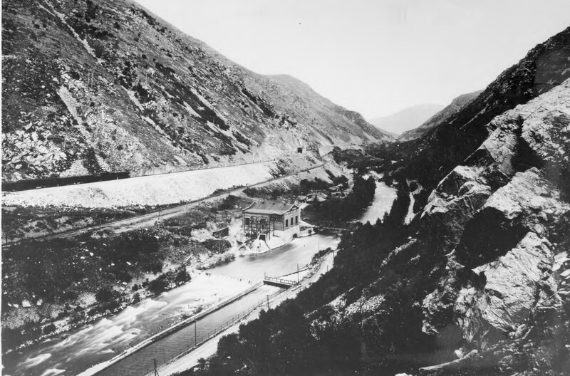
    <title type="html"><![CDATA[Devil&#039;s Gate: Weber Hydroelectric Power Plant, Weber Canyon]]></title>
    <summary type="html"><![CDATA[<p><strong><em>The Weber Hydroelectric power plant has been in operation in 1910. Despite decreased usage, the plant continues to provide power to the local grid. </em></strong></p><img src="https://www.intermountainhistories.org/files/fullsize/ebb83febf330b3a1b119d21aecc11fe7.jpg" alt="Devil&#039;s Gate " /><br/><p><span style="font-weight:400;">Devil’s Gate-Weber Hydroelectric Power Plant is located in Weber Canyon. The power station was completed in 1910 on the Weber River. Crowded between steep, winding canyon walls alongside the Union Pacific Railroad and Interstate 84, the plant has stood for over 100 years.</p><span style="font-weight:400;">The conservation movement at the turn of the century was a scientific movement focused on rational planning to increase efficient use of all natural resources. Dams were a solution to making water usage more efficient. Dams conserve water for agriculture and municipal needs as well as provide flood control and electricity. This was the Progressive Era’s ideal approach to managing water resources. Ogden and Salt Lake City were rapidly industrializing at the end of the 1800s with the construction of railroads and and better public transportation. However, an efficient power grid was needed to maintain these advances. Thus, Devil’s Gate was a vital component to support a well-organized system for Ogden and Salt Lake City. </span>
<span style="font-weight:400;">During construction, a conflict with the Union Pacific Railroad almost prevented Devil’s Gate from being built. C. K. Bannister, an engineer involved in the construction of the Pioneer hydroelectric plant in Ogden Canyon, began work on Devil’s Gate in 1900. However, with the railroad next to the Weber River, Union Pacific Railroad officials were concerned a dam would damage the railbed and temporarily halted the dam's progress. Bannister died before work resumed, and his associates, Thomas D. Dee and David Eccles, sold the property rights to the Utah Light and Railway Company. Around the same time, the president of the Union Pacific Railroad, Edward Henry Harriman, purchased sixty-percent of Utah Light and Railway Company’s stocks, thus gaining majority control of the firm. Harriman intended to upgrade the Northern Wasatch Front’s electrical output to make it efficient for his electric streetcar operation in Salt Lake City. Unable to acquire more water rights in Ogden Canyon to improve the Pioneer plant, Harriman authorized the construction of Devil’s Gate with the stipulation that precautions be taken to protect the railroad embankment from potential erosion. Construction on the dam was completed two years later. </span>
<span style="font-weight:400;">With the rapid urbanization of the Wasatch Front at the end of the 1800s, several small power companies sprung up, creating intense competition. This led to corporate consolidations and larger power grids. Devil’s Gate was completed in 1910 and was one of the first power plants in Utah intended to feed an electrical grid. Previously, power plants adjusted their output based on the local daily or seasonal needs, but Devil’s Gate would run continuously at full capacity to meet the needs of the overall system powering all of Salt Lake City and Ogden, including Salt Lake City’s electric streetcars. In 1914, ownership of Devil’s Gate passed into the private hands of Utah Light and Traction, who lost all of its power stations to the Utah Power and Light Company in 1915. </span>
<span style="font-weight:400;">Under the ownership of the Utah Power and Light Company, several modifications were made to Devil’s Gate to increase its electrical capacity and efficiency. In 1989 it was placed on the National Register of Historic Places. It still functions within a power grid today, but its role is far smaller due to the construction of larger dams which surpass Devil’s Gate electrical output. </span></p><p><em><strong><a href="https://www.intermountainhistories.org/items/show/665">For more (including 4 images) view the original article</a></strong></em></p>]]></summary>
    <published>2022-10-12T18:55:36+00:00</published>
    <updated>2026-04-17T19:32:14+00:00</updated>
    <link rel="alternate" type="text/html" href="https://www.intermountainhistories.org/items/show/665"/>
    <id>https://www.intermountainhistories.org/items/show/665</id>
    <author>
      <name>Amber Bell, Weber State University</name>
    </author>
  </entry>
  <entry>
    <title type="html"><![CDATA[Devil&#039;s Slide]]></title>
    <summary type="html"><![CDATA[<p><strong><em>Not far from the border between Utah and Wyoming is a compelling natural landmark: Devil's Slide. This landmark was so famous, a company used Devil's Slide as its logo.</em></strong></p><img src="https://www.intermountainhistories.org/files/fullsize/db1dccb467cf45e10122cdb981c728f3.jpg" alt="The Devil&#039;s Slide, Utah 1873" /><br/><p><span style="font-weight:400;">Devil’s Slide rock formation is nestled on the side of the steep Wasatch mountain range, hovering over Interstate 84. It has a height of 40 feet, and the length of the formation runs vertically hundreds of feet down a mountain. There is also an in-between space, the slide, which is about 25 feet in open space between the two vertical limestone rock slides.</span>
<span style="font-weight:400;">It is presumed that the name of the formation was given by a railroad worker named James John Walker, whose family was  one of the first to live in Croydon. According to the family history of Walker, James John was working on railway tracks in the region, likely in 1868, when some of his colleagues asked him to give a name to the strange rocky chute–his answer was Devil’s Slide.</span>
<span style="font-weight:400;">This region is rich in limestone resources, and, in 1904, </span><span style="font-weight:400;">the Union Portland Cement Company was founded by several prominent Utah citizens: Reed Smoot, M.S. Browning, Joseph Scowcroft, and James Pingree.  A company town soon sprang-up a couple hundred yards downstream from the plant site. The town was named Devil’s Slide after the nearby rock formation. </span><span style="font-weight:400;">The original plant supplied materials to most of Utah’s construction industry. After World War II, a second plant on the site replaced the original facility. </span>
<span style="font-weight:400;">At its height, the population of Devil’s Slide exceeded 250 people. As was typical with mining towns at the time, many of the workers were foreign born. Most of them cam from Italy, Austria, Greece, and Japan. Many of the these migrant workers lived in the local hotel, the largest structure in the town. This two-story building contained twenty bedrooms on the second level with each room accommodating two men to each room. Other notable buildings located in the town were the combination drug store/post office, railroad depot, mercantile, two schoolhouses, and a company clubhouse. The company laid cement sidewalks, built a baseball diamond, and planted one hundred trees throughout the village.</span>
<span style="font-weight:400;">By the mid-1980s, only a handful of families remained. By the end of the decade, the company decided to close the village altogether. All the families had moved on with the exception of the railroad section foreman who lived in a house owned by the railroad. The railroad demolished this house not long after the town was emptied.</span></p><p><em><strong><a href="https://www.intermountainhistories.org/items/show/365">For more (including 3 images) view the original article</a></strong></em></p>]]></summary>
    <published>2019-10-10T22:48:52+00:00</published>
    <updated>2026-04-17T19:32:07+00:00</updated>
    <link rel="alternate" type="text/html" href="https://www.intermountainhistories.org/items/show/365"/>
    <id>https://www.intermountainhistories.org/items/show/365</id>
    <author>
      <name>Jesse Wayment, Weber State University</name>
    </author>
  </entry>
  <entry>
    <title type="html"><![CDATA[Eccles Community Arts Center<br />
]]></title>
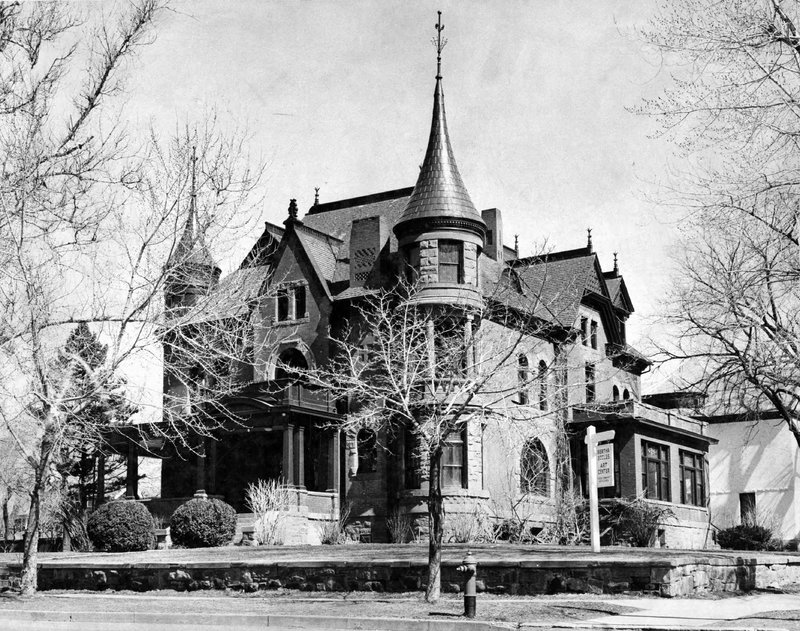
    <summary type="html"><![CDATA[<p><strong><em>The Bertha Eccles Community Art Center embodies the legacy of its owner as a leader in the cultural and educational activities in Ogden, Utah.</em></strong></p><img src="https://www.intermountainhistories.org/files/fullsize/204b067ecd1b651a2feb2277234be780.jpg" alt="Bertha Eccles residence" /><br/><p>The present-day Bertha Eccles Community Art Center is a Queen Anne styled Victorian home built in 1893. It's red brick was imported from the Midwest and red sandstone from northern Utah.  The original owner, James Clarence Armstrong was a wealthy banker and Weber County commissioner in the 1890's.  Samuel A. Whitaker most likely designed the home.  Armstrong sold the home in 1896 to David Eccles, another prominent businessman in northern Utah. Eccles met his first wife, Bertha Marie Jensen at the Weber Stake Academy which eventually became what is now Weber State University. The Eccles extensively remodeled the interior with woodwork of maple, quartered oak, and maple.</p><p>Eccles second wife, Ellen Stoddard, lived in Oregon and then in Logan. Between his two polygamous wives, Eccles fathered 21 children. He also founded at least 56 companies in five western states. Those businesses included sugar factories, banks, railroads, coal mining companies, and lumber yards. During the 50 years Bertha Eccles lived in the home, it became a prominent center for Ogden’s educational and cultural activities. Mrs. Eccles was one of the founders of the Girl Scout movement in Utah and was involved in the Children’s Aid Society, the Red Cross, the Drama Club, and the Child Culture Club.</p><p>After her death, the home was given to the L.D.S. Church. Then, in 1948, the home was turned over to Weber State College which converted it into a women’s dormitory and social center. When the college moved to a new campus, 1954 to 1956, the house reverted back to the L.D.S. church which then gifted it to the Ogden Arts Council which had been formed in 1953 as a coalition of several groups and clubs in Ogden interested in civic and cultural developments in the community. The Bertha Eccles Community Art Center opened in October 1959. In 1976, the name of both the facility and the non-profit organization that supports it was changed to the Eccles Community Art Center. A gallery store was renovated in the 1913 carriage house and opened in May 1985. In 1999, a complex was built on the grounds to accommodate the offices of the Ogden Symphony Ballet Association as well as to house ongoing educational programs. </p><p>Besides displaying artwork, the Center provides space for the Junior League of Ogden, the Palette Club, the Weber County Heritage Foundation, and the Symphony Guild, and other organizations. Classes in graphics, ceramics, painting, drawing, sculpture, drama, and ballet, are taught during the year. Following Bertha Eccles inspirations, this building continues to serve the community and supports various cultural activities. </p><p><em><strong><a href="https://www.intermountainhistories.org/items/show/265">For more (including 4 images) view the original article</a></strong></em></p>]]></summary>
    <published>2019-02-01T05:22:40+00:00</published>
    <updated>2026-04-17T19:32:04+00:00</updated>
    <link rel="alternate" type="text/html" href="https://www.intermountainhistories.org/items/show/265"/>
    <id>https://www.intermountainhistories.org/items/show/265</id>
    <author>
      <name>Faith Connors, Weber State University</name>
    </author>
  </entry>
  <entry>
    <title type="html"><![CDATA[Echo Railroad Depot]]></title>
    <summary type="html"><![CDATA[<p><strong><em>The Echo Railroad Depot was moved to its present site in Coalville in 1975.</p></strong></p><img src="https://www.intermountainhistories.org/files/fullsize/d1e07ea7df89d14108a032b609935e98.jpg" alt="The Echo Railroad Depot " /><br/><p><span style="font-weight:400;">In 1861, the town of Echo, Utah was founded. When tracks were laid down in Echo, the town shifted from an agricultural community to a railway hub. By 1869, the first of many trains passed through the area and its first railway station. As was common, young men flocked to Echo for work on the railway. Once this initial depot was completed, only a small number of these men remained in the town to settle down and continue work in the area. </span>
<span style="font-weight:400;">By 1880, a second depot was completed and was used until 1913, when a third and final depot was erected. It was a popular and important place for much of northern Summit County. People came from miles around to receive the latest news, telegrams, and the results of sports games. The building also had living quarters for the acting agent and his family. A kitchen, pantry, living room and 2 bedrooms. Occasionally, extra space was used for newcomers until they found homes nearby.  </span>
<span style="font-weight:400;">The town continued to grow and thrive thanks to these depots, drawing people and resources into the town. One of the depot's employees, Mike Tsoukatos, a native of Greece, designed an elaborate garden outside the depot and named it the Park. Tsoukatos used his own money to bring in beautiful plants and flowers that were the envy of all gardeners in the area. Sadly, when Tsoukatos retired, the garden was left neglected and was eventually laid over with gravel to make a parking lot.</span>
<span style="font-weight:400;">As time passed and railways gave way to other modes of transportation, the town morphed from vital to unneccessary and unknown. In 1960, the final steam engine made its way through the Echo Railroad Depot. However, thanks to the efforts of Henry Pennybaker, Pennybaker and other volunteers moved the building to its present location just west of the Summit County Fairgrounds in Coalville. It serves as the North Summit County Senior Citizen Center.</span></p><p><em><strong><a href="https://www.intermountainhistories.org/items/show/697">For more (including 4 images) view the original article</a></strong></em></p>]]></summary>
    <published>2022-11-04T17:36:15+00:00</published>
    <updated>2026-04-17T19:32:15+00:00</updated>
    <link rel="alternate" type="text/html" href="https://www.intermountainhistories.org/items/show/697"/>
    <id>https://www.intermountainhistories.org/items/show/697</id>
    <author>
      <name>Scarlett Alexis Wilson, Weber State University</name>
    </author>
  </entry>
  <entry>
    <title type="html"><![CDATA[El Monte Golf Course Clubhouse<br />
]]></title>
    <summary type="html"><![CDATA[<p><strong><em>The El Monte clubhouse was built with local and federal funds in 1934-1935. It is a fine example of bungalow style architecture used in a recreational setting.</p></strong></p><img src="https://www.intermountainhistories.org/files/fullsize/c765270ee01407d547d566a43a4faa10.jpg" alt="El Monte Clubhouse" /><br/><p>In 1928, with support from the Ogden Golf and Country Club, efforts were begun to secure a municipal golf course for Ogden. Led by florist Fred A. Huish (1866 – 1949) and other sports boosters, the course was to be located near El Monte Springs, at the mouth of Ogden Canyon. The Springs (formerly the Ogden Canyon Resort, 1895-1927) was a local resort which offered swimming, dancing, and picnicking activities. </p><p>El Monte Springs closed in 1932 because of the economic crisis of the Great Depression and the city considered leasing the facilities for use by the municipal golf players. However, the next year, the city opted to seek federal funds to build a clubhouse. Utah was one of the states most severely affected by the Great Depression.  As a consequence, it received substantial federal funding from New Deal programs. Perhaps the most prominent of these were building programs -- 233 public works buildings were constructed in the state of Utah.  Of these, 15 were constructed within Weber County.  The El Monte Golf Course Clubhouse was one of these projects.   </p><p>Funded by the Federal Emergency Relief Administration (FERA), the clubhouse project received $17,000, which was coupled with $5,500 from the city of Ogden.  Eber F. Piers (1889 – 1961) was hired as the architect. Piers came to Utah from Colorado in 1908 to work at an architecture firm.  In 1910, he opened his own firm and became a distinguished practitioner. Over the course of his career he designed over 300 buildings throughout the greater Ogden area.  Many of them, including the El Monte Clubhouse, are still in use today.</p><p>Most of the materials for construction, including the stonework on the exterior of the building, were taken from Ogden Canyon. The Clubhouse is a fairly simple, bungalow style building with a gable roof.  The exterior stonework continues inside to frame the large fireplace.  Most of the original decorations and paintings still adorn the walls.  It is a simple, yet elegant design that adds a certain beauty to the small golf course it accompanies.  Both the course and the clubhouse are still owned by the city of Ogden.</p><p><em><strong><a href="https://www.intermountainhistories.org/items/show/263">For more (including 4 images) view the original article</a></strong></em></p>]]></summary>
    <published>2019-01-26T04:21:27+00:00</published>
    <updated>2026-04-17T19:32:04+00:00</updated>
    <link rel="alternate" type="text/html" href="https://www.intermountainhistories.org/items/show/263"/>
    <id>https://www.intermountainhistories.org/items/show/263</id>
    <author>
      <name>Kiselya Plewe, Weber State University</name>
    </author>
  </entry>
  <entry>
    <title type="html"><![CDATA[Episcopal Church of the Good Shepherd<br />
]]></title>
    <summary type="html"><![CDATA[<p><strong><em>Although there has been several additions, the original Episcopal Church of the Good Shepherd still stands as one of best examples of Carpenter Gothic architecture in Utah.</p></strong></p><img src="https://www.intermountainhistories.org/files/fullsize/4c51af976d91afeeedf67eae83aeef54.jpg" alt="Episcopal Church of the Good Shepherd with the Red Door of Welcome" /><br/><p>On January 18, 1874, the first church bells of Ogden rang out. The source of the ringing bells came from the Episcopal Church of the Good Shepherd. The Church was established in Ogden May 23, 1867 under to leadership of Daniel Sylvester Tuttle (1837 - 1923), who had been recently consecrated missionary bishop of Montana, Idaho, and Utah. While in Utah, Tuttle oversaw the construction of St Mark’s, the first non-LDS religious building in Utah, followed by the establishment of St. Mark's School for boys and girls in 1867, St. Mark's Hospital in 1872, and Rowland Hall school for girls in 1881-- all in Salt Lake City.</p><p>However, the Ogden church was overseen by newly ordained minister James Lee Gillogly (1842-1881), who with his wife Lydia Lucelia (1846-1936) came from Connecticut. Gillogly  conducted services first in the Union Station waiting room and then in an abandoned saloon (the corner of 24th and Wall).  Finally, in 1871 he bought the land on which the church resides today. The money for this church was donated by John Hammersley of New York as a way to memorialize his daughter who had passed away in childbirth. On  26 April 1874 the cornerstone was laid by Bishop Tuttle and the building was  consecrated 6 February 1874. </p><p>The church is an example of “Carpenter Gothic” style of architecture. It was built using stones hauled in by oxen from Mendon, Utah. The designs for the church were provided by Gordon W. Lloyd of Detroit, Michigan, There are two stone plaques in the church originally placed on either side of the alter and later moved to the back of the church in 1978. These plaques are in memory of John Hammersley’s daughter Catherine Livingston and of James Lee Gillogly.</p><p>The church bell arrived around Christmas 1878 from New York. It weighs 515 pounds. The bell is still in use today. A 30 bell carillon was added in 1968. It was the first of its kind on the Wasatch front. </p><p>In 1899, the school run by the church was sold and the money was used to remodel the building. The church was expanded to the south in 1906, again to the south in 1952, and Tuttle Hall was added to the west in 1956. In 1942, the double wooden doors leading into the Church were painted red as a symbol of welcome. The red doors also indicate the Holy Spirit is within. Windows have been added above and sidelights removed from the main entrance. </p><p>In 1949, parts of the church were remodeled.  A new alter was added to the back of the church and a new stained-glass window. This window and all future windows were made by Mr. Skinner of  the Charles Connick studio in Boston, Mass. with funds donated by members of the congregation. </p><p><em><strong><a href="https://www.intermountainhistories.org/items/show/270">For more (including 5 images) view the original article</a></strong></em></p>]]></summary>
    <published>2019-02-07T00:11:54+00:00</published>
    <updated>2026-04-17T19:32:04+00:00</updated>
    <link rel="alternate" type="text/html" href="https://www.intermountainhistories.org/items/show/270"/>
    <id>https://www.intermountainhistories.org/items/show/270</id>
    <author>
      <name>Kirstan Forthman, Weber State University</name>
    </author>
  </entry>
  <entry>
    <title type="html"><![CDATA[Farr Better Ice Cream Company<br />
<br />
]]></title>
    <summary type="html"><![CDATA[<p><strong><em>The Farr Better Ice Cream Company is a much enjoyed company in Ogden and carries the name of a distinguished family.</em></strong></p><img src="https://www.intermountainhistories.org/files/fullsize/a03d7025255d91f9772ce55dfddd71a9.jpg" alt="Farr Better Ice Cream store" /><br/><p>The Farr family has been in Utah for over a century. Lorin Farr (1820-1909)  came to Utah in 1847 as part of the Mormon migration.  He settled in the city of Ogden and was elected as the first mayor  in 1851, an office he held for many years. He had five wives with whom he had 36 children.</p><p>The Farr families were  involved in several businesses,  including grist mills and coal companies. Sons from Lorin’s third wife Olive, Asael (1866-1961) and his brothers David and Valasco, established an ice business in 1890 -- then called the Fresh Pond Ice Company. They cut ice from ponds during the winter, loaded the ice blocks onto horse drawn sleighs, and stored them in their insulated warehouse in downtown Ogden.  During the summer, the ice was peddled on the streets of Ogden. Eventually Farr Brothers Ice Company had three ice houses on the Ogden River, with a capacity of three thousand tons of ice. The company became the largest of the ice companies in Ogden, and for some years even furnishing ice for railroad cars shipping fruit to California and Chicago.</p><p>In 1904, the Farr Brothers, the Mountain Ice Co (owned by Elijah and  Lorenzo Farr), the M. T. Jones Coal & Ice Com., the John Farr Coal & Ice Co., and the George Smith Sons Ice Co. all consolidated to form the Citizens’ Ice Co. Asael Farr established a coal company with the slogan “Farr Better Coal.” That company continued to operate into the 1940s.</p><p>Asael got back in the ice business in 1920 after his father’s death with the establishment of Asael Farr & Sons Co. -- manufacturers of “pure artificial ice,” out of the first commercial ice plant in a five state area. Unfortunately for the Farr family, General Electric created the original refrigerator, originally called the ‘monitor top,’ in 1927 which limited ice delivery businesses. However, this did not  stop the Farrs from considering other related businesses. </p><p>For two years Asael, his wife (Georgena Julia Drake) and their children  researched and then started making ice cream. The Farr family began with three flavors: vanilla, chocolate and strawberry.  One scoop of ice cream cost a nickel. Within a few years, Dan Gardiner, a grocer salesman saw a great opportunity to start selling the Farr Better Ice Cream in grocery stores.  The business grew exponentially. </p><p>By the 1990’s, Farr Ice Cream had outgrown their Ogden facility and in 2000 partnered with Russell’s Old Fashioned Ice Cream in Salt Lake City, to secure a more efficient and larger plant. Farr Ice Cream  has developed over six hundred flavors of ice cream. The company continues as one of America’s oldest operating ice cream shops.</p><p><em><strong><a href="https://www.intermountainhistories.org/items/show/271">For more (including 6 images) view the original article</a></strong></em></p>]]></summary>
    <published>2019-02-07T00:28:26+00:00</published>
    <updated>2026-04-17T19:32:04+00:00</updated>
    <link rel="alternate" type="text/html" href="https://www.intermountainhistories.org/items/show/271"/>
    <id>https://www.intermountainhistories.org/items/show/271</id>
    <author>
      <name>Gibson Green, Weber State University</name>
    </author>
  </entry>
  <entry>
    <title type="html"><![CDATA[Fielding Garr Ranch]]></title>
    <summary type="html"><![CDATA[<p><strong><em>The Fielding Garr Ranch is located on the southeastern portion of Antelope Island State Park in the Great Salt Lake. This portion is called Garr Springs, which is one of the strongest and most consistent springs of the forty known springs on the Island. Archaeological findings show that there has been human activity at the springs for at least 1,000 years.</em></strong></p><img src="https://www.intermountainhistories.org/files/fullsize/11deaada2b16379ae336a217cf0e17c2.jpg" alt="The Ranch on Antelope Island" /><br/><p><span style="font-weight:400;">Fielding Garr arrived in Utah from Illinois in October of 1847. In 1848, Garr was assigned by the early Church of Jesus Christ of Latter-day Saints to build a ranch on Antelope Island. <span>Garr was asked to remain and take care of the church stock and the personal herds of Brigham Young and Heber C. Kimbell. Garr, a widower, brought his seven children with and built a five-room adobe house, a rock milk house with a natural spring running through it, and a corral. </span></p>
<span style="font-weight:400;">In 1855, Garr fell off of his horse and passed away. Briant Stringhan then became the ranch foreman. Stringham and his sons managed the ranch until his death in 1871. He had four wives and twenty-seven children. His last wife was Nancy Garr Badger, Fielding’s daughter. </span><span style="font-weight:400;">Stringham transported the stock to and from the island on a large flat-bottom boat. He grew grain and alfalfa, cultivated a large garden, and planted an orchard. During his time as foreman, the church-owned livestock company invested in valuable stallions and broodmares which were turned loose to run and breed on the island. The band of horses sometimes numbered over one thousand. During these years, the Stringhams maintained residence in Salt Lake City, yet spent considerable time at their Island home. </span><span style="font-weight:400;">In July of 1871, Briant Stringham was caught in a storm on the lake and was soaked and exposed to the chilling wind. He became ill, developed congestion of the lungs, and died the next month. He had worked on the island for nearly sixteen years.</span>
<span style="font-weight:400;">The Ranch remained under control of the LDS Church until 1870, when John Dooly Sr. purchased the entire island for one million dollars.  Dooly lived on the ranch and set up the Island Improvement Company to provide cattle and sheep for ranching. Under Dooly's management, twelve bison were also introduced to the island. </span>
<span style="font-weight:400;">The ranching operation continued uninterrupted through several owners. Just after the turn of the century, the focus of the ranch turned to sheep. Under the direction of John Dooly Jr., the sheep operation expanded to more than 10,000 sheep to become one of the largest and most industrialized ranching efforts in the western United States. When sheep ranching became unprofitable in the 1950s due to a failing wool market, the operation turned again to cattle.</span>
<span style="font-weight:400;">During the 1920s, ranch hands built stables, a sheep-shearing barn, a grain silo, a corral, a pump house, and a reservoir. In the 1950s, another round of e</span><span style="font-weight:400;">xtensive remodeling occurred on the Garr house. A concrete block addition was added to the north end, one of the two principal </span><span style="font-weight:400;">windows on the original facade was enlarged by about one-and-a-half feet, and </span><span style="font-weight:400;">one of the two original doors was closed in.</span>
<span style="font-weight:400;">The Anshutz Corporation purchased the ranch in 1972, raising livestock there until the state of Utah bought the land for a state park in 1981. High lake levels during the 1980s made the ranch inaccessible. The ranch first opened to the public in 1993 on a  limited basis. In 1997, the Utah State Legislature appropriated $3.6 million to pave the eleven-mile dirt road that leads from the island's north-end recreation hub to the Garr Ranch site. The Utah Division of Parks and Recreation undertook a comprehensive project involving many partners to preserve and restore the ranch for visitors.</span></p><p><em><strong><a href="https://www.intermountainhistories.org/items/show/673">For more (including 2 images) view the original article</a></strong></em></p>]]></summary>
    <published>2022-10-19T16:30:29+00:00</published>
    <updated>2026-04-17T19:32:14+00:00</updated>
    <link rel="alternate" type="text/html" href="https://www.intermountainhistories.org/items/show/673"/>
    <id>https://www.intermountainhistories.org/items/show/673</id>
    <author>
      <name>Clint Erickson, Weber State University</name>
    </author>
  </entry>
  <entry>
    <title type="html"><![CDATA[First National Bank of Layton]]></title>
    <summary type="html"><![CDATA[<p><strong><em>Established in 1905, the First National Bank of Layton was one of only six banks in Utah to be in business for over 100 years. It operated as First National Bank of Layton until 2019, when it merged with Glacier Bank. </em></strong></p><img src="https://www.intermountainhistories.org/files/fullsize/6e0bd0aba6258621d2d507ced518396d.jpg" alt="Farmer&#039;s Union Building " /><br/><p><span style="font-weight:400;">The First National Bank of Layton was founded in 1905 by nine farmers and local businessmen in response to rapid economic expansion and what scholars refer to as the “Americanization” of the state, a period of increased entrepreneurial spirit which took place from 1890 to 1920. Initially funded with a starting investment of only $25,000 the bank’s focus was on small businesses and local families. The bank has tried to retain the same feeling of intimacy and personability since then. Describing itself as a community bank, it remained locally owned and active in a wide variety of community service initiatives. When the bank celebrated its centennial anniversary in 2005, having survived many wars and economic crises, it was praised by the Utah Bankers Association as “an amazing accomplishment.”</span>
<span style="font-weight:400;">The bank was initially established in a building designed by the prominent Utah architect William Allen, who is noted for also designing the Davis County Courthouse and the Kaysville Tabernacle. William Allen, an eccentric London-born man, learned architecture via a correspondence course and often infused his buildings with personal style. Many of the buildings he designed mixed different staples of architecture like Victorian spires and Greek columns. The original building that housed the First National Bank of Layton is no longer in use. The bank is currently housed in the Farmer’s Union Building, another of Allen’s designs.</span>
<span style="font-weight:400;">The Farmer's Union Building is significant for housing the Farmers’ Union Mercantile Institution, the first commercial enterprise in Layton, Utah, incorporated in 1909. The building was built in three sections, the first being erected in 1890, the second shortly thereafter, and the third in 1930. </span><span style="font-weight:400;">It was the first prominent business structure erected in Layton and served as the community's primary meeting hall, social center, and recreational facility. Various events were hosted in the building including, church events, sports games, town meetings, and others. Later, the second floor was used as apartments. The Farmer's Union business closed in 1956 and various businesses filled the vacancy until the First National Bank of Layton gained ownership.</span><span style="font-weight:400;"> The bank merged with Glacier Bank out of Kalispell, Montana in 2019.</span></p><p><em><strong><a href="https://www.intermountainhistories.org/items/show/664">For more (including 3 images) view the original article</a></strong></em></p>]]></summary>
    <published>2022-10-12T16:55:14+00:00</published>
    <updated>2026-04-17T19:32:14+00:00</updated>
    <link rel="alternate" type="text/html" href="https://www.intermountainhistories.org/items/show/664"/>
    <id>https://www.intermountainhistories.org/items/show/664</id>
    <author>
      <name>Zach Baker, Weber State University</name>
    </author>
  </entry>
  <entry>
    <title type="html"><![CDATA[Hall Fruit Farm]]></title>
    <summary type="html"><![CDATA[<p><strong><em>The Hall Fruit Farm has produced fruit in North Ogden for over one hundred years. The family farm continues to serve its community and surrounding areas with fresh fruit. </em></strong></p><img src="https://www.intermountainhistories.org/files/fullsize/e08fda23886eeecc022566ed06f8057c.jpg" alt="Henry Hall and his wife. " /><br/><p><span style="font-weight:400;">The Hall Fruit Farm is a beloved historic site in North Ogden, Utah. The farm dates back to 1905 when John Hall Sr. built his family home and bought nearly one hundred acres of land. John Hall Sr. was born in 1857 in England. He met his sweetheart Annie Parratt and the two found their way to Ogden, Utah, in October 1883. In 1890, John built one of the first brick homes in the North Ogden area and, in 1905, he developed just over 100 acres of orchard land near the mouth of the North Ogden canyon, an area known as “The Bench.”John was also a skilled cabinet maker and built many homes in the Ogden area from 1890 to 1925.</span>
<span style="font-weight:400;">His son, Henry C. Hall, and his wife, Amelia Ford Hall, took over the farm in 1915 and built the reputation of the farm. Henry was diligent in the farm's upkeep and found great joy in the production of fruit. The farm produced mainly peaches and apples and was known throughout Utah and surrounding states.  </span>
<span style="font-weight:400;">Eventually, the farm was named H.C. Hall Fruit Farm. After Henry passed, the farm was taken over by his two sons, Henry R. Hall and George F. Hall. While Henry took the lead, the two renamed the farm the Hall Brothers Fruit Farm. Henry was active in the Weber County Horticultural Society and became president in 1960. </span>
<span style="font-weight:400;">In 2000, the Hall Brothers Fruit Farm was incorporated. The Hall Fruit Farm continues to produce fruit for small stores and farmer's markets around the state. Despite the passing of both Henry and George, the farm remains within the family and continues to serve fresh fruit to Weber County.</span></p><p><em><strong><a href="https://www.intermountainhistories.org/items/show/669">For more (including 2 images) view the original article</a></strong></em></p>]]></summary>
    <published>2022-10-17T16:27:03+00:00</published>
    <updated>2026-04-17T19:32:14+00:00</updated>
    <link rel="alternate" type="text/html" href="https://www.intermountainhistories.org/items/show/669"/>
    <id>https://www.intermountainhistories.org/items/show/669</id>
    <author>
      <name>Claire Crismon, Weber State University</name>
    </author>
  </entry>
  <entry>
    <title type="html"><![CDATA[Hardware Ranch ]]></title>
    <summary type="html"><![CDATA[<p><strong><em>Hardware Ranch in Hyrum, Utah was created to keep elk away from the lower valley and its inhabitants. Today, the ranch is a popular spot for visitors to get a closer look at elk and other wildlife. </p></strong></p><img src="https://www.intermountainhistories.org/files/fullsize/f81afce9790f5a0a5591caf762da95b5.jpg" alt="An Elk in Hardware Ranch" /><br/><p><span style="font-weight:400;">In the 1940s, complaints from people in the valley of the Blacksmith Fork Canyon about elk eating their stores of hay began to be more frequent. This prompted the state of Utah to purchase the Hardware Ranch to prevent elk from entering the lower parts of the Blacksmith Fork Canyon and interfering with the settlers in the valley of inner Hyrum. The state then created the winter feeding program to keep elk out of the valley. </span>
<span style="font-weight:400;">Before the ranch was a place for Elk to receive food and refuge during the winter, it was a sawmill during the 1870s, then later home to Utah’s largest Cheese company during the 1890s. Lehi Curtis, who homesteaded the ranch during the late 1860s, was part of the 16th Company of pioneers who emigrated to Utah. The company was led by Lehi’s father Uriah Curtis and had a total of 266 members; it traveled from Kanesville, Iowa in 1852 to Cache County, Utah. Upon arriving at Cache Valley, Lehi helped plan out a road that lead to Blacksmith Canyon. Soon, farmers began to further settle the area. </span>
<span style="font-weight:400;">Hardware Ranch was purchased 8 years after the Pittman-Robertson Act was passed. The act, also known as the Wildlife Restoration Act, allowed for revenue from the sporting arms tax to be used as for restoring and managing wildlife. In 1945, the revenue was used to purchase the Ranch from the family estate of Ernst Lorentz Petersen. The original size of the ranch was 7,560 acres but acquisitions by the state enlarged it to about 19,000 acres.During the first year, 120 Rocky Mountain Elk were fed through the winter. Within a few years the number of elk rose to above 500. </span>
<span style="font-weight:400;">In 1971, The state built an education center with two outside viewing areas to observe the elk. Sleigh rides were also provided to further enjoy the ranch and the local elk. In 1988, the Utah Legislature cut funding support for the sleigh rides. Outrage led the state to approve a fee structure and the sleigh rides resumed.</span>
<span style="font-weight:400;">Although the purpose of the ranch was initially to prevent the Elk from eating the hay from the settlers and to keep the elk out of the lower valley, the ranch has become a popular site in Utah and has had thousands of visitors since its opening. People can bring their children to have very close interactions with the Elk and learn about the history of the Ranch. The ranch also provides researchers with vital information in the preservation of wildlife. </span>
<span style="font-weight:400;">The elk is the state animal of Utah. Once winter forage grasses are covered in snow, Division of Wildlife Resources stadd begin feeding the elk. The feed is grown by the ranch. Soon, between 400 and 700 animals migrate to the ranch for the winter. </span></p><p><em><strong><a href="https://www.intermountainhistories.org/items/show/691">For more (including 5 images) view the original article</a></strong></em></p>]]></summary>
    <published>2022-11-03T15:08:01+00:00</published>
    <updated>2026-04-17T19:32:15+00:00</updated>
    <link rel="alternate" type="text/html" href="https://www.intermountainhistories.org/items/show/691"/>
    <id>https://www.intermountainhistories.org/items/show/691</id>
    <author>
      <name>Rosa Rodriguez, Weber State University</name>
    </author>
  </entry>
  <entry>
    <title type="html"><![CDATA[History of Willard, Utah]]></title>
    <summary type="html"><![CDATA[<p><strong><em>Willard has many beautiful geographical and historical features that make this town one of a kind. </em></strong></p><img src="https://www.intermountainhistories.org/files/fullsize/92bd5188fd227684fccb9e5b6eebf1f9.jpg" alt="Shadrach Jones House, 101 West Second South, Willard, Box Elder County, UT" /><br/><p><span style="font-weight:400;">The Willard area was first surveyed by Henry G. Sherwood in 1851. As a member of the 5th Company of Ten in the Brigham Young pioneer company, Henry Sherwood was one of the first Mormon settlers in Utah. The town was originally named Willow Creek due to the numerous flowers located around the creek. In 1857, it was renamed “Willard,” in honor of the Mormon apostle, Willard Richards. </span>
<span style="font-weight:400;">Willard was originally a fort used to fend off the local Native American groups like the dominant Shoshone. In fact, Willard might have had the biggest fort in any Utah town during this time period. The fort was later proved unnecessary and was torn down. The leftover stones of the fort were spread throughout the town in building homes.  </p><p>The construction of these rock homes are credited to Shadrach Jones. Jones was a stonemason from Wales who converted to Mormonism in 1849. Later he moved to Willard, Utah. He participated in the building of the Logan temple and was later sent on a mission back to Wales where he died. His home still stands today, along with several other homes constructed by Jones. </p>
<span style="font-weight:400;">Eventually a booming fruit economy was created in Willard. Local Native Americans played a key role in developing the fruit business in Willard. The natives taught the citizens of Willard how to care for service berries, haw-berries and chokecherries. Years later, a cannery was built. The newly established railroad line increased the exportation of these fruit goods and the Willard fruit industry's popularity. </span>
<span style="font-weight:400;">The flood of 1923 impacted Willard in a devastating manner. Overgrazing in the region had prevented rain water from being absorbed into the ground when the snow melted from the mountains. The property loss was enormous. The </span><i><span style="font-weight:400;">Box Elder News</span></i><span style="font-weight:400;"> reported that, “Hundreds of fine farms have been covered with rock and gravel, crops washed away, animals and poultry destroyed, and orchards ruined. The loss will run into hundreds of thousands of dollars.” In fact, it wasn't until October that the sanitary conditions in Willard met state health standards after flooding. </span><span style="font-weight:400;">This flood also impacted the Willard cemetery, as numerous pioneer graves were washed away with the waters. Only a few headstones survived the flooding.</span>
<span style="font-weight:400;">In 1964, a reservoir was built in Willard as part of the Weber Basin Project to create a reservoir to store surplus water from the Ogden and Weber Rivers.  The resulting reservoir was drained of salt water and refilled with fresh water directly from the Weber River.</span></p><p><em><strong><a href="https://www.intermountainhistories.org/items/show/368">For more (including 3 images) view the original article</a></strong></em></p>]]></summary>
    <published>2019-10-23T03:21:04+00:00</published>
    <updated>2026-04-17T19:32:07+00:00</updated>
    <link rel="alternate" type="text/html" href="https://www.intermountainhistories.org/items/show/368"/>
    <id>https://www.intermountainhistories.org/items/show/368</id>
    <author>
      <name>Jesus Monroy, Weber State University</name>
    </author>
  </entry>
  <entry>
    <title type="html"><![CDATA[John Moses Browning Home<br />
]]></title>
    <summary type="html"><![CDATA[<p><strong><em>This home was that of John Moses Browning who earned international prominence for his revolutionary designs of sporting and military firearms.</p></strong></p><img src="https://www.intermountainhistories.org/files/fullsize/e2e8e8fc9df8d30b9a356b39ed5ef3e7.jpg" alt="John M. Browning Home" /><br/><p>John Moses Browning (1855-1926) “was world renowned for his genius as an inventor, and took out more patents for improvements in fire-arms than any other man in the world.” A native of Ogden, Utah, John “was attached to the city and place of his birth.” Indeed, it could be said that “no one man did more to make the name of this city and state known over the world than John M. Browning.”</p><p>John was the son of Jonathan Browning and Elizabeth Caroline Clark, one of his father’s three wives. The Brownings had moved to Utah as part of the migration of members of The Church of Jesus Christ of Latter-Day Saints. Jonathan was a gunsmith; as a young boy, John spent hours in his father’s shop. He filed his first patent for the “J.M. Browning Single Shot Rifle” in 1879. (Eventually he held 128 patents.) The year before, he had co-founded with his younger brother the John Moses and Matthew Sandifer Browning Company, later renamed Browning Arms Company. The firearms they designed caught the attention of the Winchester Repeating Arms Company. From 1883, Browning worked in partnership with Winchester to produce a series of rifles and shotguns.</p><p>About 1900, Browning invented the first auto-loading shotgun and moved his family into their new home, designed by architect Sam Whittaker. The home  is two and a half stories. Its exterior is made from a combination of sandstone, smooth bricks and rippled natural looking brick. Its beautiful exterior is enhanced by big, clear, intricately shaped windows. </p><p>The home remained the residence of the family until around 1940 when it was converted into an apartment building.The building was purchased by the Y.W.C.A. in 1946 and was used as a women’s shelter until it was purchased by a law firm and used as office space. The home was listed on the National Register of Historic Places in 1973. In 2001 a family moved in and renovated the home then put it up for sale in 2011.</p><p>The home is privately owned so access is unfortunately restricted but it is a great reminder of the man who changed the history of firearms forever and left a lasting mark on the history of Ogden and of Utah. </p><p><em><strong><a href="https://www.intermountainhistories.org/items/show/268">For more (including 5 images) view the original article</a></strong></em></p>]]></summary>
    <published>2019-02-02T06:21:37+00:00</published>
    <updated>2026-04-17T19:32:04+00:00</updated>
    <link rel="alternate" type="text/html" href="https://www.intermountainhistories.org/items/show/268"/>
    <id>https://www.intermountainhistories.org/items/show/268</id>
    <author>
      <name>Brock Bergquist, Weber State University</name>
    </author>
  </entry>
  <entry>
    <title type="html"><![CDATA[Kay&#039;s Cross]]></title>
    <summary type="html"><![CDATA[<p><strong><em>Built in the 1940s and blown up in the 1990s, Kay’s Cross is cherished by the people of Kaysville, Utah. Legends surround the site, which is known to be haunted.</em></strong></p><img src="https://www.intermountainhistories.org/files/fullsize/f6c0c1be04d431c3ab862e7e0c5613c5.jpg" alt="Remains of Kay&#039;s Cross" /><br/><p><span style="font-weight:400;">Kay’s Cross is a 20ft by 13ft cross and an important symbol for the people of Kaysville, Utah. However, no one knows where the cross came from or who created it. Myths prevail regarding its source including one of a murderous polygamist. According to lore, the story says that a husband murdered six of his seven wives and either buried the seventh beneath the cross or put her heart in the cross. Mysticality seems to surround the symbol. Some people have claimed to see werewolves in the area during the full moon. Others have claimed to see the ghost of the seventh wife whose body was laid to rest in the hallowed cross. Some locals say that during a full moon, the cross will glow. </p>
<span style="font-weight:400;">According to one local whose family previously owned the land which included Kay's Cross, the real story is less horrific than a murederous polygamist. Elden Kingston and his two wives lived on the land in the early twentieth century. Elden Kingston (1909-1948) left the Church of Jesus Christ of Latter-Day Saints in the 1920s to found a group of polygamous families. He established the Davis County Co-op of Bountiful, Utah. Eventually, the Kingston family met a man named Krishna Venta (Francis Pancovic, 1911-1958) who had founded a cult: the Wisdom, Knowledge, Faith and Love Fountain of the World. Venta preached that he was Jesus Christ and the Second Coming was near at hand. According to Jack, Venta convinced the family to build a cross in his honor. Later, Venta fled to California where he continued to gain followers. </span>
<span style="font-weight:400;">During the 1980s, devil worship was soon introduced to the site. Locals claim that devil worshipers would steal local chickens to sacrifice. Other animals, such as dogs and raccoons, have been found dead on the site. In 1992, the cross was bombed. There have been claims that the bomb was so loud, it echoed through the city. Some believe the Kaysville police bombed it hoping to reduce the number of trespassers on private property, but the police department denies any involvement in the bombing. The demolition did not stop trespassers, and the site soon became a place of mischief. </span><span style="font-weight:400;">Directly across the site of Kay's Cross, a man hanged himself in 2005, further adding to the despair surrounding the cross. Nevertheless, some are still anxious to see the site of Kay's Cross and, d</span><span style="font-weight:400;">uring October, the owners of the land open the site for visitors.  </span></p><p><em><strong><a href="https://www.intermountainhistories.org/items/show/366">For more (including 4 images) view the original article</a></strong></em></p>]]></summary>
    <published>2019-10-19T00:55:23+00:00</published>
    <updated>2026-04-17T19:32:07+00:00</updated>
    <link rel="alternate" type="text/html" href="https://www.intermountainhistories.org/items/show/366"/>
    <id>https://www.intermountainhistories.org/items/show/366</id>
    <author>
      <name>Claire Larson, Weber State University</name>
    </author>
  </entry>
</feed>