<?xml version="1.0" encoding="UTF-8"?>
<feed xmlns="http://www.w3.org/2005/Atom">
  <title type="text">Intermountain Histories</title>
  <updated>2026-04-17T19:32:20+00:00</updated>
  <generator uri="http://framework.zend.com" version="1.12.20">Zend_Feed_Writer</generator>
  <link rel="alternate" type="text/html" href="https://www.intermountainhistories.org/"/>
  <link rel="self" type="application/atom+xml" href="https://www.intermountainhistories.org/items/browse?output=rss2"/>
  <id>https://www.intermountainhistories.org/</id>
  <author>
    <name>Intermountain Histories</name>
    <uri>https://www.intermountainhistories.org</uri>
  </author>
  <link rel="hub" href="https://pubsubhubbub.appspot.com/"/>
  <entry>
    <title type="html"><![CDATA[Sheep Eaters (Mountain Shoshones) in the Greater Yellowstone Ecosystem]]></title>
    <summary type="html"><![CDATA[<p><strong><em>The Sheep Eaters (also known as Mountain Shoshones, Tukudika, or Snake Indians), resided in Yellowstone National Park, the Wind River Mountains in Wyoming, and parts of central Idaho, until the reservation era.</p></strong></p><img src="https://www.intermountainhistories.org/files/fullsize/5a9a77ddc55c952bffe2d127a3c16817.jpg" alt="Tukudika (Sheepeater) men, women, and children at Medicine Lodge Creek, Idaho, in 1871." /><br/><p><span style="font-weight:400;">Much of the history of the Sheep Eaters emanates from archeological and ethnographic research. Many scholars believe their origins are in the Great Basin, though that continues to be debated. Trappers like Osborne Russell were among the first Euro-Americans to leave written accounts about the Sheep Eaters. Russell noted that a group of about 22 Sheep Eaters he met were “neatly clothed in dressed deer and Sheep skins of the best quality and seemed to be perfectly contented and happy … [They had] about 30 dogs on which they carried their skins, clothing, provisions etc on their hunting excursions. They were well armed with bows and arrows pointed with obsidian…” Early descriptions provide useful information, but they also often encouraged stereotypes. For example, Philetus Norris, Superintendent of Yellowstone National Park in 1877, described the Sheep Eaters as “vanished” and “hermits."</span>
<span style="font-weight:400;">The Sheep Eaters domesticated dogs they used to carry packs and pull travois. Their name came from their main source of food, Rocky Mountain Bighorn Sheep, which the dogs may have assisted in hunting. Pots and pipes carved from steatite represent another distinguishing characteristic of Sheep Eater culture.</span>
<span style="font-weight:400;">The Sheep Eaters participated in the Rocky Mountain fur trade from the 1820s through the 1850s. During the 1870s, the Lemhi Valley Agency was created to oversee the removal of the Sheep Eaters, Bannocks, and Shoshones to Lemhi Valley in central Idaho. In 1880, they began to be relocated to Fort Hall, but some Sheep Eaters remained in Yellowstone, eventually joining the Eastern Shoshones on the Wind River Reservation. Idaho censuses continued to list Sheep Eaters as a distinct group through the early part of the twentieth century.</span>
<span style="font-weight:400;">It is important to note that the Sheep Eaters did not “vanish” or go extinct as Norris and others described. </span><span style="font-weight:400;">Today, some of the Sheep Eater descendants live on the Wind River Reservation in Wyoming and the Fort Hall Reservation in Idaho. </span>
<span style="font-weight:400;">In 2023, the town of Jackson, Wyoming issued a land acknowledgement concerning the Sheep Eaters:</span>
<ul>
<li><em><span style="font-weight:400;">We recognize that the land we are gathering on is the ancestral homeland of the Mountain Shoshone People who stewarded it for thousands of years and that many other tribes also lived upon and cared for this area … With gratitude, we honor Indigenous peoples, past and present. We also acknowledge the sovereignty of the Native nations closest to Jackson whose land was taken through broken treaties that resulted in the creation of the Wind River and Fort Hall Indian Reservations. We recognize this acknowledgement is simply a first step. The Town of Jackson is committed to continued and informed action to connect with Indigenous people.</span></em></li>
</ul></p><p><em><strong><a href="https://www.intermountainhistories.org/items/show/887">For more (including 3 images) view the original article</a></strong></em></p>]]></summary>
    <published>2025-04-19T02:12:32+00:00</published>
    <updated>2026-04-17T19:32:20+00:00</updated>
    <link rel="alternate" type="text/html" href="https://www.intermountainhistories.org/items/show/887"/>
    <id>https://www.intermountainhistories.org/items/show/887</id>
    <author>
      <name>Emmaretta Barnett, Brigham Young University</name>
    </author>
  </entry>
  <entry>
    <title type="html"><![CDATA[The Humboldt River and the Inevitable Railroad]]></title>
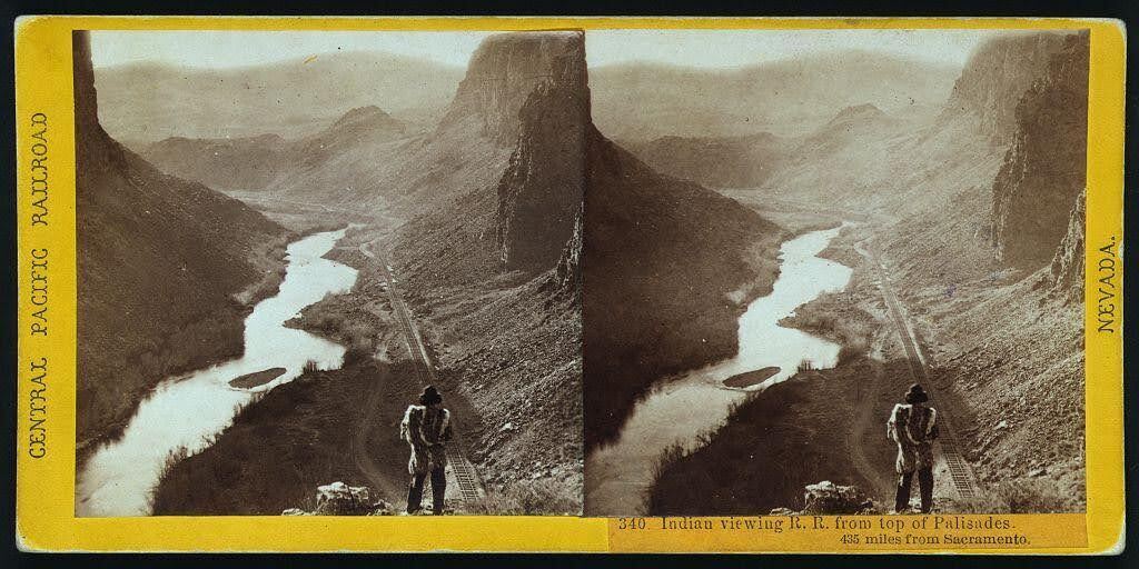
    <summary type="html"><![CDATA[<p><strong><em>Alfred A. Hart’s photo neatly captures the relationship that the United States had with Indigenous nations in the 19th century: persistent encroachment on and abuse of Native land. </em></strong></p><img src="https://www.intermountainhistories.org/files/fullsize/68061ca83529f9dba3c1da8a26419a79.jpg" alt="“Indian viewing railroad from top of Palisades. 435 miles from Sacramento.” " /><br/><p>Winding through the arid region of modern-day north central Nevada, the Humboldt River provided resources to support communities of a few hundred people. Punodungahnivain, or “Place where the house is” in Western Shoshone, was an area at the mouth of the South Fork River, between modern-day Carlin, Elko, and South Fork, that was home to Western Shoshone. </p><p>Water—and therefore the river—is sacred for the Western Shoshone, or “Newe” meaning “The People.” The Humboldt represents an important thoroughfare in ancient and modern trade routes, connecting goods from the Pacific with those in the Great Basin and western Rocky Mountains. The fertile river enabled Indigenous communities to thrive between modern-day Carlin and Elko. Roots and berries grew along the river, attracting birds and animals, and pine nut resources grew in the nearby Ruby mountains. The Shoshones hunted waterfowl, antelope, trout, gopher, rabbit, and beaver. </p><p>Trappers such as Peter Skene Ogden from the Hudson’s Bay Company arrived in the Humboldt region in the 1820s. They trapped as many beavers as possible in order to make it unprofitable for their competition, nearly wiping out the beaver population for a generation. After the discovery of gold at Sutter’s Mill in 1848, miners and settlers traveled along the Humboldt by the tens of thousands, negatively impacting the environment, depleting finite resources, and disrupting Indigenous lifeways. The California Trail transected Western Shoshone Territory throughout the 1840s through 1860s. Then, in the 1860s, the Central Pacific Railroad began building their Railroad from Sacramento, California, westward towards Utah Territory to join with the Union Pacific at Promontory Summit on May 10, 1869. </p><p>By the time CPRR worker Alfred A. Hart took the photo below, dated between 1865 and 1869, natural resources had already been depleted all along the Humboldt. Hart took hundreds of photographs as he traveled with the company, and many of them feature Shoshones. The completion of the railroad brought even more people west, who settled near the tracks in order to benefit from future commerce. These newcomers claimed the most fertile places for themselves and divided up ancestral Shoshone and Paiute lands. </p><p><em><strong><a href="https://www.intermountainhistories.org/items/show/851">For more (including 3 images) view the original article</a></strong></em></p>]]></summary>
    <published>2024-09-25T01:12:50+00:00</published>
    <updated>2026-04-17T19:32:19+00:00</updated>
    <link rel="alternate" type="text/html" href="https://www.intermountainhistories.org/items/show/851"/>
    <id>https://www.intermountainhistories.org/items/show/851</id>
    <author>
      <name>Ella Henricksen, Brigham Young University</name>
    </author>
  </entry>
  <entry>
    <title type="html"><![CDATA[Shoshone Falls: The Niagara of the West]]></title>
    <summary type="html"><![CDATA[<p><strong><em>If you are heading through Twin Falls, Idaho on Interstate 84, you’ll want to take a short detour on U.S. highway 93 to Shoshone Falls Park, located on the Snake River.</em></strong></p><img src="https://www.intermountainhistories.org/files/fullsize/82f0a7cd60a9208c11e4d9917e0e0bc2.jpg" alt="Thomas Moran, Shoshone Falls, 1900, oil, Gilcrease Museum, Tulsa, Oklahoma." /><br/><p>Before the days of irrigation water and hydroelectricity, Shoshone Falls was an amazing sight to behold, water plunging 212 feet over the rocks, with the roar of the falls heard up to ten miles away. The falls created an impassable barrier for the migrating steelhead and salmon returning from the Pacific Ocean to spawn. In the spring, Indigenous people living throughout the Snake River Plain formed small bands to capture fish from the river and it remained an important area for Natives to gather, fish, and trade.  Downstream, fish were plentiful and provided life-sustaining food and an important component of Shoshone culture and spirituality.   </p><p>Archaeologists insist Shoshone Falls was formed over 14,500 years ago when Lake Bonneville catastrophically flooded during the Pleistocene Ice Age. A traditional Shoshone-Bannock story denotes a different story explaining the cosmology of the Shoshone/Snake River. Ejuba, a coyote, went fishing in the country of Yellowstone. On his way home, the fish and the water in his lined basket became too heavy to carry and he tripped and spilled the contents. Although he tried several times to build various rocky dams to contain the spilled water, it continually rushed over and created several waterfalls. The river that Ejuba created is known today as the Snake River. The first dam he built was Idaho Falls, the second was American Falls, and the third dam split into two parts to become Twin Falls. The last and largest dam Ejuba constructed was Shoshone Falls. Another Shoshone tale describes a maiden distraught over the separation from her lover who hurled herself into the Snake River canyon at a point near the edge of the falls, a fenced off area known as “Lover’s Leap.”</p><p>Shoshone Falls has undergone tremendous changes. The once roaring waters that were heard from miles away now dwindle to a stream. The demand for water to irrigate the land and the desire for clean hydroelectricity dictates the amount of water that plunges over the falls. When visiting the falls on such a day it is hard to imagine that a writer once compared Shoshone Falls to Niagara Falls saying, “Surely there must be a God above. . .who made these Western Falls, which soon shall mock the magic art of Eastern ones and sink them into insignificance.” Visit the falls in the early Spring if you hope to catch a glimpse of its original majesty at maximum flow. </p><p><em><strong><a href="https://www.intermountainhistories.org/items/show/850">For more (including 2 images) view the original article</a></strong></em></p>]]></summary>
    <published>2024-09-24T18:23:02+00:00</published>
    <updated>2026-04-17T19:32:19+00:00</updated>
    <link rel="alternate" type="text/html" href="https://www.intermountainhistories.org/items/show/850"/>
    <id>https://www.intermountainhistories.org/items/show/850</id>
    <author>
      <name>Rochelle A. Hewett, Brigham Young University</name>
    </author>
  </entry>
  <entry>
    <title type="html"><![CDATA[Bear Lake: Traders, Towns, and Tourists]]></title>
    <summary type="html"><![CDATA[<p><strong><em>For hundreds of years people have been drawn to Bear Lake along the Utah-Idaho Border. Shoshones, Fur Traders, Latter-day Saint Pioneers, and contemporary tourists have come to the lake for various purposes over the years, and it remains a vibrant and beautiful place to this day.</em></strong></p><img src="https://www.intermountainhistories.org/files/fullsize/6cec6f3c64c276dd0715a0c85fc6ac96.jpg" alt="Sweet Lake" /><br/><p>Bear Lake is a natural freshwater lake that is 18 miles long and 7 miles wide. It straddles the border between Utah and Idaho, which passes through the center of the lake. Renowned for
its bright blue waters, thanks to the limestone in the mountains surrounding it, Bear Lake has been dubbed the Caribbean of the Rockies. The lake and surrounding communities are also well known for the famous “Bear Lake raspberries” that grow in the area and the associated Raspberry Days festival held every August. In recent years the lake has become a tourism hot spot with vacation homes and resorts spreading along its shores.
The Shoshone inhabitants of the valley historically used the Bear Lake area for food; they fished the lake’s waters and hunted in the surrounding mountains. They called the lake “sweet lake” due to its exceptionally clear water, and the first European fur traders adopted the name “Sweet Lake” for the body of water. The name “Bear Lake” came about when a Scotsman named Donald McKenzie paddled up the Bear River in 1818. When he found the lake he named it “Black Bear Lake,” but later trappers soon dropped the adjective “Black” so the lake’s name matched the river. Fur trapping continued in the area but sharply increased in 1827 when mountain men held a rendezvous along the southern shore of the lake. Thousands of Natives from many tribes came to trade furs for guns, supplies, and other goods. Jim Bridger and Jedediah Smith were among the mountain men in attendance. Mountain men gathered to Bear Lake for another rendezvous in 1828, but it was the last one held in the valley.
From 1829 onward, the rendezvous moved into nearby Wyoming, and Shoshones continued to enjoy the Bear Lake Valley. The next group to arrive were laborers from the Logan, Utah area who were members of The Church of Jesus Christ of Latter-day Saints (sometimes nicknamed “Mormons”) and had come to search for pine trees tall enough to serve as support beams for the Logan Temple then under construction. When their reports of a fertile valley with a large lake reached Brigham Young in Salt Lake City, he sent Church apostle Charles C. Rich to settle the area in 1863.
The Mormons initially strove for peaceful relations with the Shoshones, and at first agreed to keep to the northern part of the valley while the Shoshone used the southern part in what is present-day Utah. These Latter-day Saint quickly established the small towns of St. Charles, Montpelier, Ovid, Bennington, and Fish Haven, all named for cities in Brigham Young’s native Vermont. For a few years the valley became known as “Mormon Valley.” As time went on, both the Mormon name and the agreement they had with the Shoshones faded from memory. The Latter-day Saint settlers expanded southward along the banks of the lake, adding the towns of Paris, Garden City, and Laketown. </p><p>Bear Lake continues to represent a place where people go to fish, boat, and recreate, just as the Shoshones and fur traders had.</p><p><em><strong><a href="https://www.intermountainhistories.org/items/show/592">For more (including 3 images) view the original article</a></strong></em></p>]]></summary>
    <published>2022-04-16T01:52:29+00:00</published>
    <updated>2026-04-17T19:32:12+00:00</updated>
    <link rel="alternate" type="text/html" href="https://www.intermountainhistories.org/items/show/592"/>
    <id>https://www.intermountainhistories.org/items/show/592</id>
    <author>
      <name>Jonathon Whitmore, Brigham Young University</name>
    </author>
  </entry>
  <entry>
    <title type="html"><![CDATA[Utah Lake]]></title>
    <summary type="html"><![CDATA[<p><strong><em>Utah Lake sustained indigenous populations with fresh water and fishing for centuries. Beginning in the 1800s, Mormon pioneers settled the area; nowadays, heavy industry has polluted the once welcoming water source.</em></strong></p><img src="https://www.intermountainhistories.org/files/fullsize/6c9471ba4cb86b91b4ca1e37337e562e.jpg" alt="Utah Lake" /><br/><p>Utah Lake is a freshwater body situated in the Provo–Orem area of Utah County. The Lake has been utilized for hundreds of years by a variety of Native tribes, including but not limited to the Utes, Paiutes, and Shoshones. A variety of American Indian groups such as the Fremont people lived along the lake’s shores prior to these contemporary tribes, and they all had settlements and benefitted from the lake’s resources and fresh drinking water.
Excavation sites organized by archeologist Joel Janetski have yielded a variety of culture-rich native artifacts including arrowheads, beads, shells, cooking utensils, and ceramics like clay pots. The Dominguez and Escalante Expedition of 1776 visited Utah Valley from New Mexico and described the lake and valley in glowing terms. Fur traders also frequented the area in the 1820s and 1830s. In 1847, Euro-American members of The Church of Jesus Christ of Latter-day Saints entered Utah Valley, and they eventually utilized Utah Lake as a source of food and water for agriculture. This marked the beginning of settler colonialism and Western encroachment into the region which ultimately led to numerous settler–native conflicts over the land around Utah Lake.
As one of the largest freshwater lakes west of the Mississippi River, Utah Lake historically was home to a wide variety of fish, bird, and plant species. The water now has high levels of phosphorus and calcium carbonate sediments, a result of pollution. Utah Lake remains an expansive sight for those living in the Provo–Orem area, and residents and visitors sometimes use the lake for watersports in the summer and ice fishing & skating in the winter.</p><p><em><strong><a href="https://www.intermountainhistories.org/items/show/591">For more (including 3 images) view the original article</a></strong></em></p>]]></summary>
    <published>2022-04-16T00:51:10+00:00</published>
    <updated>2026-04-17T19:32:12+00:00</updated>
    <link rel="alternate" type="text/html" href="https://www.intermountainhistories.org/items/show/591"/>
    <id>https://www.intermountainhistories.org/items/show/591</id>
    <author>
      <name>Devin Blake Sanders, Brigham Young University</name>
    </author>
  </entry>
  <entry>
    <title type="html"><![CDATA[Jean-Baptiste Charbonneau’s Grave]]></title>
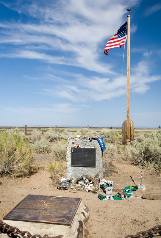
    <summary type="html"><![CDATA[<p><strong><em>Born in February 1805, Jean-Baptiste Charbonneau accompanied the Lewis and Clark Expedition as an infant before becoming a fur trader, guide, alcalde, and then a hotel manager in California.</em></strong></p><img src="https://www.intermountainhistories.org/files/fullsize/01db17a0c012fd0f8a8d4751a3066439.jpg" alt="Charbonneau gravesite" /><br/><p>Jean-Baptiste Charbonneau, son of Sacagawea and Toussaint Charbonneau, accompanied his parents on Meriwether Lewis and William Clark’s expedition for the Corps of Discovery. Although a small infant, he made the entire trek from North Dakota to the Pacific Coast and back to the Mandan Villages on the Knife River. After Sacagawea’s death in December 1812, William Clark legally adopted Jean-Baptiste and his little sister Lisette. Clark provided an education for the two children at a Catholic boarding school in St. Louis. This education opened up numerous opportunities for Jean-Baptiste throughout his life.
As an adult, Jean-Baptiste spent a substantial amount of time in Europe where he learned additional languages and skills. Returning to America, he joined the fur trade, working as a trapper with the Rocky Mountain Fur Company. His extensive knowledge of the terrain enabled him to serve as a guide for explorers, as well as for the Mormon Battalion on their route from Leavenworth to San Diego in 1846 during the Mexican–American War.
While in California, Charbonneau worked as an alcalde (mayor), panned for gold, provided interpretation services, and operated a hotel in Auburn, California. After the American Civil War and toward the end of his life, Charbonneau worked odd jobs until he learned about gold and silver strikes in Idaho and Montana. On his way to the mining rushes he traveled through Danner, Oregon, but shortly after crossing the Jordan Creek and the Owyhee River, he fell ill (likely of pneumonia) and died at sixty-one years old. Oregonians memorialized Charbonneau by erecting and dedicating a plaque to him in Danner. His place of death is located just over the border of Oregon and is close to the Lemhi Shoshone Nation of Idaho, the likely birthplace of his mother, Sacagawea.</p><p><em><strong><a href="https://www.intermountainhistories.org/items/show/585">For more (including 3 images) view the original article</a></strong></em></p>]]></summary>
    <published>2022-04-09T07:02:41+00:00</published>
    <updated>2026-04-17T19:32:12+00:00</updated>
    <link rel="alternate" type="text/html" href="https://www.intermountainhistories.org/items/show/585"/>
    <id>https://www.intermountainhistories.org/items/show/585</id>
    <author>
      <name>Taylor Mansfield, Brigham Young University</name>
    </author>
  </entry>
  <entry>
    <title type="html"><![CDATA[Sacagawea Birthplace]]></title>
    <summary type="html"><![CDATA[<img src="https://www.intermountainhistories.org/files/fullsize/da84f7bf86bc77b6104e4c22670e6f59.jpg" alt="Lemhi" /><br/><p>More than two centuries have passed since the Lewis and Clark Expedition traveled to the Pacific and back, and the expedition and its members continue to generate interest. Aside from the leaders, Meriweather Lewis and William Clark, Sacagawea may be the best-known member of the expedition. When she was around sixteen years old, she gave birth to her first child, Jean Baptiste Charbonneau. Two months later she departed on the expedition with her husband and child in tow. She made it the entire journey while carrying and tending to her child and simultaneously helping the efforts of the expedition.
Her main role in the expedition was as an interpreter between the party and Shoshones. She was likely born into the Lemhi Shoshone tribe around 1788, and her birthplace may have been somewhere between Kenney Creek and Agency Creek in Tendoy, Idaho.  Since the Lemhi Shoshone lived along the river, they fished for salmon as a dietary staple. From a young age, Sacagawea contributed to her family by gathering and preparing food. Recently, oral histories have made claims Sacagawea was Hidatsa, not Shoshone. While there is currently some controversy surrounding precisely what tribe Sacagawea came from, history does not dispute that Sacagawea lived part of her life with the Hidatsas. She did tell Lewis and Clark that she was captured while traveling across the Rocky Mountains and adopted into the Hidatsa Nation as a child and her new name was Sacagawea, meaning Bird Woman or Eagle Woman. It is likely that she learned additional agricultural skills from the Hidatsas, where she resided until her marriage as a plural wife to Toussaint Charbonneau, a French-Canadian explorer.
Although forced to leave her childhood homeland in Idaho, Sacagawea returned to the Lemhi Valley with Lewis and Clark, reuniting with the Shoshones. She then reunited with her tribal family in the place she was born and celebrated her reunion with her brother Cameahwait before continuing her journey to the Pacific.</p><p><em><strong><a href="https://www.intermountainhistories.org/items/show/584">For more (including 3 images) view the original article</a></strong></em></p>]]></summary>
    <published>2022-04-08T04:34:55+00:00</published>
    <updated>2026-04-17T19:32:12+00:00</updated>
    <link rel="alternate" type="text/html" href="https://www.intermountainhistories.org/items/show/584"/>
    <id>https://www.intermountainhistories.org/items/show/584</id>
    <author>
      <name>Taylor Mansfield, Brigham Young University</name>
    </author>
  </entry>
  <entry>
    <title type="html"><![CDATA[Sacagawea’s Alleged Gravesite]]></title>
    <summary type="html"><![CDATA[<p><strong><em>American icon Sacagawea was instrumental in the Lewis and Clark expedition. However, the circumstances surrounding her death and even when and where she died are murky and hotly contested.</em></strong></p><img src="https://www.intermountainhistories.org/files/fullsize/0deae90765f5318925358d115eade6c9.jpg" alt="Mountains at Wind River" /><br/><p>Sacagawea has inspired countless girls to have greater strength and courage in their lives. Around age 16, this Lemhi Shoshone young woman joined Lewis and Clark on their journey across the American West, acting as an interpreter and occasional guide. She did this while carrying her baby Jean Baptiste upon her back. What the Lewis and Clark Expedition achieved was impressive, but what Sacagawea achieved seems heroic and unimaginable.
Despite the important place Sacagawea holds in American history, the stories regarding her death remain contested. Some insist she died in December 1812 in South Dakota at the age of 24. Others contend she lived to age 96 and died on the Wind River Indian Reservation in Wyoming Territory in 1884, reunited with her Shoshone kinsmen. The Hidatsa use Sacagawea (meaning Bird Woman or Eagle Woman). Shoshones used Sacajawea (meaning boat-pusher).
Between 1825 and 1828, William Clark created a list of the expedition members of the Corps of Discovery and identified where each of them were. Next to Sacagawea’s name he wrote, “dead.” This matches other primary accounts that record one of Toussaint Charbonneau’s wives died at Fort Manuel in December 1812. Additional primary sources indicate that Clark adopted her two children, Jean Baptiste and Lisette, the following year in 1813, offering additional credence to the notion that she likely died in December 1812.
Clark’s record conflicts with Shoshone oral histories about Bird Woman’s life and death recorded by University of Wyoming historian Grace Hebard in the early twentieth century. She interviewed several Shoshones and recorded their traditions. They described Sacagawea having left her abusive husband Charbonneau and traveled to Colorado territory to live with her cousins, the Comanches. She purportedly married a warrior named Jerk Meat, raised a family, and eventually returned home to live out her twilight years with the Eastern Shoshone on the Wind River Reservation. There she lived out her last days with her son Jean Baptiste and eventually died in peace. Her son is also reported by some to have died there and to be buried in an unmarked grave somewhere in the Wind River Mountain range. Other accounts clearly identify Jean Baptiste Charbonneau as dying in Danner, Oregon in 1866.
It is conceivable that these oral accounts attributed to the Bird Woman may also refer to another Shoshone woman who had life experiences similar to Sacagawea. No matter where her final resting place is, the grave in the Ethete cemetery marked with Sacajawea’s name stands as an important historical landmark because of how it honors this great Shoshone woman, pays tribute to her memory, and recognizes her contributions to history. While the spot marked here at the Sacajawea Cemetery near Fort Washakie, Wyoming may not be her actual resting place, it is still a remarkable place to visit for any American who wants to celebrate the life of this great explorer, or for any woman who wants to connect with a true heroine.</p><p><em><strong><a href="https://www.intermountainhistories.org/items/show/579">For more (including 3 images) view the original article</a></strong></em></p>]]></summary>
    <published>2022-03-12T09:50:55+00:00</published>
    <updated>2026-04-17T19:32:12+00:00</updated>
    <link rel="alternate" type="text/html" href="https://www.intermountainhistories.org/items/show/579"/>
    <id>https://www.intermountainhistories.org/items/show/579</id>
    <author>
      <name>Sara Grundvig, Brigham Young University</name>
    </author>
  </entry>
  <entry>
    <title type="html"><![CDATA[Washakie: a Shoshone Ghost Town]]></title>
    <summary type="html"><![CDATA[<p><strong><em>The Northwestern Band of Shoshone called Washakie home for generations as they sought to rebuild their community after the tragic events of the Bear River Massacre. With land and assistance provided by the Church of Jesus Christ of Latter-day Saints, the Shoshone created a new way of life while still preserving connections to their culture and heritage.</em></strong></p><img src="https://www.intermountainhistories.org/files/fullsize/bbb86b5ba57e9f35dc5592ad66263f6b.jpg" alt="Washakie Cemetery" /><br/><p>After the tragic assault by Colonel Patrick Conner and his California Volunteers on a peaceful encampment of Shoshone at Bear River on the morning of January 29, 1863, the drastically reduced band of Shoshone spent years roaming Northern Utah without a viable means of subsistence. Eventually, over a hundred members of this small band of Shoshone, led by Chief Sagwitch, converted to The Church of Jesus Christ of Latter-day Saints. After several years on their own, Sagwitch appealed to the Church, whose members offered assistance and allowed the band to settle and farm on Church-owned land near the modern Utah–Idaho border in 1880. In addition to the farmland provided by the Church, many members of the band also appealed to the federal government and received land close by under several homesteading acts of the late-nineteenth century. The Shoshone named this community Washakie after a respected leader in the greater Shoshone community who remained an integral part of their nation for almost a century.
While at Washakie, the Northwestern Band of the Shoshone adapted to the farming lifestyle of the nearby settlers. While doing their best to preserve elements of their culture through regular cultural gatherings and celebrations, the Band also learned new skills and practices from their white neighbors, many of whom came to them from the Church. The Washakie residents learned skills such as carpentry, farming, sheepherding, and firing bricks. They built a church house in the community to use as a place of worship and gathering. The Shoshone at Washakie even used the building as a schoolhouse for a few decades, though the teachers at the Washakie school were White. During Washakie’s heyday, the community thrived as a small city.
As time drew on, however, outside pressures pushed many of the Shoshone residents of Washakie out of the community. With the onset of the Second World War, Utah became a center for supporting the war effort. For some Shoshone, better-paying jobs drew them out of residence in Washakie and into areas where they could work Utah’s booming defense industry. This exodus of residents curtailed the Washakie community life possible with the remaining Shoshone population. Because the Church of Jesus Christ still considered itself the owner of Washakie’s land, they began reclaiming it in the summer of 1960 by burning seemingly abandoned homes to the ground so they could sell the plots to nearby farmers. However, many of the homes that appeared to be abandoned were only seasonally empty, as the Shoshone residents often visited their northern relatives on a Shoshone reservation in Idaho or were away for other reasons. The home burning marked the end of the Washakie community and marked the beginning of a tense relationship between the Northwestern Band of Shoshone and the Church. The Northwestern Band of Shoshone, who had been devastated by the violent events of the Bear River Massacre in 1863, once again became victims of whites pushing them off their land and out of their homes. Today, the Washakie community is gone. Only a few structures remain, including the church building and a cemetery.</p><p><em><strong><a href="https://www.intermountainhistories.org/items/show/566">For more (including 4 images) view the original article</a></strong></em></p>]]></summary>
    <published>2021-12-18T10:35:57+00:00</published>
    <updated>2026-04-17T19:32:12+00:00</updated>
    <link rel="alternate" type="text/html" href="https://www.intermountainhistories.org/items/show/566"/>
    <id>https://www.intermountainhistories.org/items/show/566</id>
    <author>
      <name>William Handley, Brigham Young University</name>
    </author>
  </entry>
  <entry>
    <title type="html"><![CDATA[Desert National Wildlife Refuge and Competing Agendas in Nevada]]></title>
    <summary type="html"><![CDATA[<p><strong><em>Desert National Wildlife Refuge encompasses a large portion of southern Nevada, spanning from Area 51 to the northern tip of the greater Las Vegas area, and is part of a wildlife refuge complex protecting Nevada’s unique and rare species. However, the Nevada desert offers promising opportunities for many, and the contest for its usage is seemingly never-ending.</em></strong></p><img src="https://www.intermountainhistories.org/files/fullsize/74cfd8c703bc5ebd8b073c9827586909.jpg" alt="Petrogylphs at Desert NWR" /><br/><p>Desert National Wildlife Refuge (Desert NWR), the largest national wildlife refuge in the contiguous United States, spans vast tracts of land in Nevada. Adjacent to the Nevada Nuclear Test Site and overlapping the Nellis Air Force Range, the refuge and surrounding preserves form the Desert National Wildlife Refuge Complex, home to several rare and endangered species such as the Devils Hole pupfish. Though established to preserve Nevada’s natural landscape, various interest groups in the region are in continual conflict over how to use Desert NWR, some sharing its preservationist goals and some not.
The US Fish and Wildlife Service created Desert NWR in 1936 primarily to protect desert bighorn sheep. In doing so, the government also recognized southern Nevada’s high biodiversity and varied desert environments, from the oasis of Ash Meadows to the landscape of the Great Basin. However, not all shared this appreciation. When military officials searched for a place to test nuclear weapons in the wake of World War II, they chose Nevada’s “wasteland” as the site that would generate the least collateral damage. The Nuclear Test Site settled in Nye County, Nevada in 1951, coming to rest on land that the Shoshone people had called home for millennia.
The Western Shoshone Nation quickly challenged the military’s appropriation, pointing to the terms set in the 1863 Treaty of Ruby Valley. Though the US government had acknowledged Shoshone sovereignty in the region, they still asserted that their nuclear agendas took precedent. In addition to the Western Shoshone’s rights to the land, the environmental impact of nuclear testing quickly became a pressing issue due to how far wind carried radioactive remnants of bomb tests. The Test Site terminated above-ground testing in the 1990s and fully closed in 2010. In the late 2010s and early 2020s, however, the federal government continued to encroach on the refuge’s land. Conflicts about the nearby Air Force range have proposed both expanding and withdrawing its reaches, with the debate still ongoing. The presidency of Donald Trump even reopened discussions on the proposed nuclear waste site at nearby Yucca Mountain.
The prevalent and continued debate over Nevada desert land shares fundamental elements with many land rights conversations in the West. Paiute and Shoshone presence within the Refuge confines is impossible to ignore, especially with petroglyphs and sacred sites scattered across the landscape. Military presence also touches upon another sensitive topic in Western states—the overwhelming amount of federally-owned land. Much of the strong Nevadan opposition to test site expansion stems from resentment towards the government, as many feel that the state government should maintain more dominion over local land. Yet the state itself continues to violate the dominion of those who have used the land far longer than any Nevada citizen. For a so-called wasteland, the deserts of southern Nevada draw much attention.</p><p><em><strong><a href="https://www.intermountainhistories.org/items/show/545">For more (including 4 images) view the original article</a></strong></em></p>]]></summary>
    <published>2021-12-17T01:03:55+00:00</published>
    <updated>2026-04-17T19:32:11+00:00</updated>
    <link rel="alternate" type="text/html" href="https://www.intermountainhistories.org/items/show/545"/>
    <id>https://www.intermountainhistories.org/items/show/545</id>
    <author>
      <name>Len Truelsen, Northern Arizona University</name>
    </author>
  </entry>
  <entry>
    <title type="html"><![CDATA[Mae Timbimbo Parry]]></title>
    <summary type="html"><![CDATA[<p><strong><em>Mae Timbimboo Parry was the tribal historian for the Northwestern Shoshone Tribe and preserved her tribe’s history by recording the oral histories she heard throughout her childhood. She was a gifted storyteller, a talented beadwork crafter, and an influential leader in her community.</em></strong></p><img src="https://www.intermountainhistories.org/files/fullsize/2686ac8c0f81d7cbfc73a6ac298c8e12.jpg" alt="Utah Indian Cooperative Council" /><br/><p>Mae Timbimboo Parry was born May 15, 1919, in Washakie, Utah. Established in the 1880s, Washakie was a homestead for members of the Northwestern Shoshone Tribe, many of whom were descendants of survivors of the Bear River Massacre.
During her childhood, Mae attended several schools including the Sherman Institute in Riverside, California as well as the Washakie Day School, both of which were Indian boarding schools designed to assimilate Indian children into American culture. With the motto of “Kill the Indian, and Save the Man,” the schools attempted to strip Native American students of their indigenous cultures and languages in the hopes they would assimilate into mainstream American society. While attending the Washakie Day School, one of Mae’s teachers had her stand in front of class, proceeding to tell her “Mae, you are going to turn out to be just like these other children, sitting in the dirt and being useless for the rest of your life.” Contrary to her teacher’s beliefs, Mae excelled in school. She went to Bear River High School where she began to write all of the oral stories she heard growing up from her tribal leaders as well as her grandfather Da-boo-zee, or Yeager Timbimboo, who was present at the Bear River Massacre. She continued her education at LDS Business College (now called Ensign College), where she earned a degree in English.
Throughout her life, Mae continued to share the history of her tribe and was well-known for being a wonderful storyteller. She became the tribal historian and was passionate about passing the stories on to younger generations. Through her meticulous records of oral traditions, Mae was able to shift the dialogue surrounding the Bear River Massacre. Originally, the massacre was remembered as the “Battle of Bear Creek,” and her people were viewed as troublesome Indians that fought against the local militia. Mae corrected the story, showing her people were massacred despite attempts to surrender and make peace, bringing justice to her tribe.
During her time as tribal historian, Mae worked with local and federal governments to help all Native Americans. She was a representative on the White House Council for Indian Tribal Affairs where she worked with Native leaders to create and implement programs for Native Americans and distribute resources. She also served on Utah’s Indian Cooperative Council where she helped create the Native American Graves Protections and Repatriation Act, which returned Native American artifacts and human remains to their tribes. Her efforts to serve Native Americans were incredibly valuable. In 1986 she was named “Utah’s Honorary Mother of the Year” and in 1996 she received the Utah Women’s Achievement Award.
In addition to preserving her tribal history through words, Mae also carried on family tradition through her beautiful beadwork. Her grandson Darren Parry remembered her constantly working on buckskin gloves, moccasins, or other objects, carefully placing the beads to create beautiful designs.
Mae passed away on May 20, 2007 in Clearfield, Utah. Her role as teacher, storyteller, and historian preserved the history of the Northwestern Shoshone Tribe, and her legacy is continued by her grandson Darren, the current tribal historian, who continues to share her stories with the world.</p><p><em><strong><a href="https://www.intermountainhistories.org/items/show/478">For more (including 3 images) view the original article</a></strong></em></p>]]></summary>
    <published>2021-09-11T08:10:52+00:00</published>
    <updated>2026-04-17T19:32:10+00:00</updated>
    <link rel="alternate" type="text/html" href="https://www.intermountainhistories.org/items/show/478"/>
    <id>https://www.intermountainhistories.org/items/show/478</id>
    <author>
      <name>Bethany Erickson, Brigham Young University</name>
    </author>
  </entry>
  <entry>
    <title type="html"><![CDATA[Creation of Wind River Reservation<br />
]]></title>
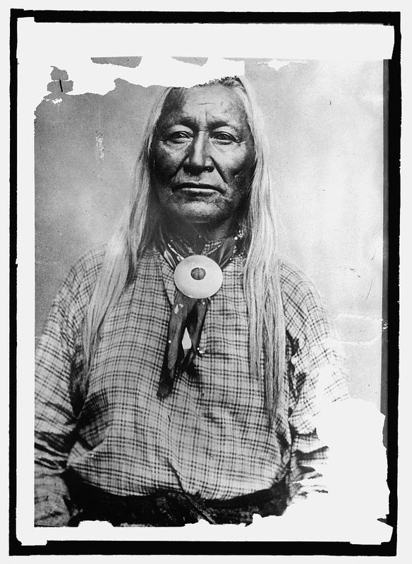
    <summary type="html"><![CDATA[<p><strong><em>“The Wind River Valley which is the favorite hunting ground for these Indians, will be the most suitable locality…” -Luther Mann Jr., Indian Agent over the Fort Bridger Indian Agency</p></strong></p><img src="https://www.intermountainhistories.org/files/fullsize/0534f93f1289fd0db2228344bf3947e0.jpg" alt="Washakie" /><br/><p>The Eastern Shoshone tribe occupied the region north of Utah and around Fort Bridger. After Mormon pioneers began settling the area around Bear River, Shoshone Chief, Washakie, and his band of Eastern Shoshone were forced to leave the region. Washakie was known for his peacekeeping. Federal officials favored him because he tried to keep peace between his tribe and white settlers. While Washakie was successful in keeping relative peace between his people and the setters moving into Shoshone territory, he still fought for his people. After signing the Fort Bridger Treaty of 1863, Washakie determined that his people needed a permanent place to settle.  </p><p>Looking for an area to set aside as a reservation, the Wind River Valley in western Wyoming was at the top of the list. Indian Agent, Luther Mann, was the first to recommend the area for a possible reservation. He said that it was “one of the finest valleys in the mountains.” The Eastern Shoshone used the region as their winter hunting grounds because of the large herds of buffalo. However, it took nearly a decade for a reservation to be set aside. One superintendent over Indian Affairs mentioned in his reports that “the Wind River Valley which is the favorite hunting ground for these Indians, will be the most suitable locality, unless it shall be found to be rich in mines of gold and silver and springs of petroleum.” Unfortunately, Indian affairs did not take precedence over a higher federal agenda. Establishing peace with the Native Americans was important, but it did not trump the possibility of gold.  </p><p>However, the reservation was finally established by treaty in the Fort Bridger Treaty of 1868. Although Washakie and the Indian agency had been campaigning for a reservation for years, the reservation was organized as a protection for the white settlers. The Indian wars on the plains were coming further west, which concerned many white settlements. Incidents on the Bozeman trail and raids on mining communities left white settlers fearful. Seeing an opportunity to protect the settlements, the reservation was created as buffer between the warring tribes and the white settlements.  The Eastern Shoshone have maintained the reservation since 1868. Washakie continued to lead his people from the reservation. </p><p><em><strong><a href="https://www.intermountainhistories.org/items/show/244">For more (including 3 images) view the original article</a></strong></em></p>]]></summary>
    <published>2019-01-12T00:20:57+00:00</published>
    <updated>2026-04-17T19:32:03+00:00</updated>
    <link rel="alternate" type="text/html" href="https://www.intermountainhistories.org/items/show/244"/>
    <id>https://www.intermountainhistories.org/items/show/244</id>
    <author>
      <name>Rachel Hendrickson, Brigham Young University</name>
    </author>
  </entry>
  <entry>
    <title type="html"><![CDATA[Making Peace with the Eastern Shoshone <br />
]]></title>
    <summary type="html"><![CDATA[<p><strong><em>“Friendly and amicable relations are hereby re-established between the bands of the Shoshone nation, parties hereto, and the United States; and it is declared that a firm and perpetual peace shall be henceforth maintained between the Shoshone nation and the United States.” -Article I, Treaty of Fort Bridger 1863</em></strong></p><img src="https://www.intermountainhistories.org/files/fullsize/0f9f1f3010409997a655f2e86c01686e.jpg" alt="Fort Bridger depicting Indians and Soldiers" /><br/><p>By 1862, the relationship between settlers and the Shoshone and Bannock tribes had deteriorated. According to Indian Agent Luther Mann’s report in 1862, “Large numbers of the Shoshones, in conjunction with the Bannocks, who range along the southern boundary of Washington Territory, have been committing upon the emigrants travelling to California and Washington some of the most brutal murders ever perpetrated upon this continent.” Federal officials felt that this violence was due to the lack of game left in the territory. The increasing number of white settlers in the region began to encroach on the Indians hunting grounds. Mann concluded that, “There is very little game in this Territory, by which the Indians are enabled to procure the necessary means of subsistence… Owing to the limited amount of means placed in my hands, I have been unable, as fully as I should have desired, to supply their wants, thereby preventing them from supplying themselves by unlawful means.” </p><p>However, while tensions were rising with the mixed bands of Bannock and Shoshone, the Eastern Shoshone tribe remained above violence. Mann’s opinion says that, “I am glad to say, however, that Washakee, the head chief of the Shoshones, and his band, have abstained from any acts of violence or theft, which have characterized a large portion of the tribe... I am apprehensive that a general outbreak of hostilities will take place throughout this entire region of country.” The Eastern Shoshone were more concerned about getting enough supplies to last them through the winter. Mann wrote that he found the tribes in “very destitute condition,” and Superintendent James Doty requested that the Indian Commissioner provide more funds for supplies, hoping to prevent the Indians from “committing depredations and interfering with the transportation of the mail.” Hence, the necessity of a treaty was needed.</p><p>On July 2, 1863, the Eastern Shoshone tribe signed a treaty with US federal officials. Washakie, the most famous Shoshone leader was among the ten bands of Eastern Shoshone represented in the treaty. The treaty stipulated peace between the Eastern Shoshone and US government. First it established that the overland mail trails, telegraph lines, and railroad tracks that ran through Shoshone territory were under the protection of the United States. It also established the boundaries of the Shoshone territory and provided annuities for the Shoshone people. The treaty stipulated that the US government would compensate the Shoshone tribe $10,000 annually in supplies for a twenty year period for the loss of game on their land. Additionally, the Shoshone would receive an immediate payment of $6000 in clothing and provisions for the upcoming winter. The treaty officially signaled peace between the Eastern Shoshone and the federal government. However, while the treaty was a step in bringing peace for the Shoshone it did not establish a reservation. It would take a later treaty to give an official reservation for the Eastern Shoshone people. </p><p><em><strong><a href="https://www.intermountainhistories.org/items/show/242">For more (including 3 images) view the original article</a></strong></em></p>]]></summary>
    <published>2019-01-11T22:57:50+00:00</published>
    <updated>2026-04-17T19:32:03+00:00</updated>
    <link rel="alternate" type="text/html" href="https://www.intermountainhistories.org/items/show/242"/>
    <id>https://www.intermountainhistories.org/items/show/242</id>
    <author>
      <name>Rachel Hendrickson, Brigham Young University</name>
    </author>
  </entry>
  <entry>
    <title type="html"><![CDATA[Washakie Township: The Mormon Alternative to Fort Hall]]></title>
    <summary type="html"><![CDATA[<p><strong><em>Ninety miles south of Fort Hall, the Washakie Township represented an alternative to reservation life. Following the conversion of over 100 Shoshones to Mormonism, Washakie was founded by the Church of Jesus Christ of Latter-day Saints in 1880. Here, the Northwestern Band of Shoshone made their home as ranchers and farmers until the 1960s. Today, Washakie is a ghost town owned by an energy company.</em></strong></p><img src="https://www.intermountainhistories.org/files/fullsize/8b325daaf094746edcec1fae096ab1d2.jpg" alt="[Untitled]" /><br/><p>They were among the only survivors: Chief Sagwitch and his Northwestern Band of Shoshone were destitute and hopeless after three quarters of their tribe were murdered in the 1863 Bear River Massacre. One decade later, Sagwitch made peace with the occupiers of his homeland by joining the Church of Jesus Christ of Latter-day Saints. Through the help of the LDS church, the Shoshone began a homestead community away from Fort Hall where they felt they would be free to practice their new religion.</p><p>For the next eighty years, hundreds of Shoshone made their homes in Washakie. At its pinnacle in the 1920s, more than 300 worked there as farmers and ranchers. At first, they relied on subsistence agriculture, which they supplemented with deer meat. As their land base grew, the Northwestern Band began selling excess crops of wheat and potatoes to the LDS Church. Additionally, they raised purebred cattle and sheep, which they sold at premium prices in the local market.</p><p>After 1900, very few of the Northwestern Band of Shoshone returned to Fort Hall except for larger intertribal Shoshone gatherings, especially basketball games. At Washakie, they were allowed to speak Shoshone and perform traditional ceremonies—which the US government wanted to eliminate. The local grade school—established and maintained by the LDS Church—taught the students to speak, read, and write English but did not discourage the exploration of Shoshone culture. After elementary school, most students attended nearby high schools and a remarkably high percentage also attended college. </p><p>By World War II, Washakie was a relatively successful agricultural experiment, but the inhabitants still lived without electricity in small shacks and tents. Seeking better economic opportunities, many found employment at the nearby Hill Airforce Base. Drawn away by the allure of steady pay and higher education, few young people stayed in Washakie, and its population dwindled until the land was sold in the 1970s.       </p><p><em><strong><a href="https://www.intermountainhistories.org/items/show/206">For more (including 6 images) view the original article</a></strong></em></p>]]></summary>
    <published>2018-06-08T03:24:07+00:00</published>
    <updated>2026-04-17T19:32:02+00:00</updated>
    <link rel="alternate" type="text/html" href="https://www.intermountainhistories.org/items/show/206"/>
    <id>https://www.intermountainhistories.org/items/show/206</id>
    <author>
      <name>Natalie Larsen, Brigham Young University</name>
    </author>
  </entry>
  <entry>
    <title type="html"><![CDATA[Ranching and Success on Fort Hall: The Indian Stockmen’s Association<br />
]]></title>
    <summary type="html"><![CDATA[<p><strong><em>During the 1910s, conflict and failure demarcated the relationship between the Shoshone-Bannock of Fort Hall and the federal government. To protest the government’s discriminatory policies and lack of economic opportunity, the successful Indian Stockmen’s Association was founded in 1920.</em></strong></p><img src="https://www.intermountainhistories.org/files/fullsize/4f9bf5bea0ec4b2194f39b77ef6d21ff.jpg" alt="[Untitled]" /><br/><p>From the creation of the Fort Hall Indian Reservation until the 1934 Indian Reorganization Act, the reservation was controlled by the federal Bureau of Indian Affairs (BIA). Without clearly understanding the cultural and physical needs of the Shoshone-Bannock, the BIA and on-site agents often made decisions that conflicted with local values and harmed the general welfare. For example, horses symbolized power, mobility, and strength to the Shoshone-Bannocks, who required at least ten steers as payment for just one horse. To the government, the horses were just obstacles in the way of progress. The final straw was in September 1920, when government agents quietly rounded up 1,200 horses and sold them for less than $6 apiece—to be turned into chicken feed.</p><p>Meanwhile, individual ranchers were successfully circumventing the reservation bureaucracy by communally sharing allotment lands for cattle grazing. In 1917, Thomas LeSieur, a Cherokee married to a Shoshone woman, sold his cattle for $8.45 a head, the highest price for range beef cattle in Idaho that year. Others on the reservation had also realized the economic potential cattle provided, especially Ralph Dixey and Pat Tyhee, both Shoshones.  Dixey stated in 1917, “This is a cattle country; my people here are stock raisers.” Land-use policies under previous Indian agents gave preference to non-Native ranchers with the pretext that their herds were more profitable. Outraged by discriminatory policies, the loss of their horses, and the general poverty of the reservation, Dixey and Tyhee joined with other Shoshone-Bannock ranchers to form the Fort Hall Indian Stockmen’s Association (ISA) in 1921. The organization’s objectives were to protect the reservation range land, to raise better cattle and horses, to make the herds self-sustaining, to build a sales yard at Fort Hall, and to foment cooperation with white neighbors.</p><p>By the end of 1921, the ISA had about 5,000 head of cattle on the reservation. Local newspapers and ranchers were amazed by the quality of the herds. The ISA became so successful that the herdsmen built stock yards and feeders to expand the scope of their operation. Buyers came from as far away as Los Angeles to look at the cattle, but the ISA was insistent that the cattle first be sold locally. Partially, this goal would help offset costs, but it was also a useful tool to build bridges between Shoshone-Bannock ranchers and their non-Native neighbors. The cattle operation turned out to be a popular and very profitable experiment for many decades afterward and was subsequently copied by several other Native American groups in the west.</p><p>The Indian Cattlemen’s Association continued to be a powerful player in tribal economics and politics throughout the twentieth century, but today the ISA has been superseded by Shoshone-Bannock Tribal Enterprises.</p><p><em><strong><a href="https://www.intermountainhistories.org/items/show/205">For more (including 3 images) view the original article</a></strong></em></p>]]></summary>
    <published>2018-06-08T03:06:17+00:00</published>
    <updated>2026-04-17T19:32:02+00:00</updated>
    <link rel="alternate" type="text/html" href="https://www.intermountainhistories.org/items/show/205"/>
    <id>https://www.intermountainhistories.org/items/show/205</id>
    <author>
      <name>Natalie Larsen, Brigham Young University</name>
    </author>
  </entry>
  <entry>
    <title type="html"><![CDATA[The Division of Fort Hall: Allotment and Land Loss]]></title>
    <summary type="html"><![CDATA[<p><strong><em>In the late nineteenth and early twentieth centuries, most Americans believed that the best way to help Native Americans was through forced assimilation. Laws and social activists worked to inhibit traditional culture and practices. Allotment was one such attempt to split Shoshone-Bannock land holdings and fracture their culture. </em></strong></p><img src="https://www.intermountainhistories.org/files/fullsize/5b1e3607ba88fd30b3d4662b9902f36a.jpg" alt="Idaho Indian Reservations 1896" /><br/><p>After the Native Americans were forced onto reservations, the U.S. Congress was concerned that most tribes had not discontinued collective living. In response, the Dawes Act was passed in 1887 to “allot” reservation lands to individual owners. This meant that the reservations would be divided among the tribe members so that necessity would require them to adopt agriculture. Each reservation was thus partitioned, including Fort Hall. </p><p>In 1868, Fort Hall was comprised of 1.8 million acres for approximately 4,500 residents. Between 1888 and 1902, the Shoshone-Bannock were pressured to cede away nearly a third of the reservation to the growing town of Pocatello. With the remaining land, each tribe member would receive a certain share. Married couples received 160 acres, single adults 80 acres, and children 40 acres. All of the “excess” was sold by the government. Before any of this could happen, the Shoshone-Bannock requested that all properties have access to irrigation. The first of the irrigation projects was completed in 1911. Between 1911 and 1913, half a million acres were allotted to Shoshone-Bannock tribe members. The remaining 600,000 acres were subsequently sold to non-Natives for a fraction of their worth.</p><p>Land allotment was divisive in its implementation, but the controversy surrounding the policy has not disappeared in the intervening century. For some, division of tribal lands into individual allotments was an unmitigated economic disaster. Thrown into the turbulence of crop prices and agriculture, many either went hungry or had to sell their land. For another segment of the population, allotment proved an opportunity to successfully experiment with ranching and farming. Local newspapers tended to exaggerate the truth with regards to both the successes and failures of allotment, so it is difficult to reach a historical consensus.</p><p>Today, 97 percent of Fort Hall is under the control of the tribe or individual Shoshone-Bannock owners. These lands are farmed individually or rented out to local farmers.</p><p><em><strong><a href="https://www.intermountainhistories.org/items/show/203">For more (including 4 images) view the original article</a></strong></em></p>]]></summary>
    <published>2018-06-08T01:30:07+00:00</published>
    <updated>2026-04-17T19:32:02+00:00</updated>
    <link rel="alternate" type="text/html" href="https://www.intermountainhistories.org/items/show/203"/>
    <id>https://www.intermountainhistories.org/items/show/203</id>
    <author>
      <name>Natalie Larsen, Brigham Young University</name>
    </author>
  </entry>
</feed>