<?xml version="1.0" encoding="UTF-8"?>
<feed xmlns="http://www.w3.org/2005/Atom">
  <title type="text">Intermountain Histories</title>
  <updated>2026-04-17T19:32:21+00:00</updated>
  <generator uri="http://framework.zend.com" version="1.12.20">Zend_Feed_Writer</generator>
  <link rel="alternate" type="text/html" href="https://www.intermountainhistories.org/"/>
  <link rel="self" type="application/atom+xml" href="https://www.intermountainhistories.org/items/browse?output=rss2"/>
  <id>https://www.intermountainhistories.org/</id>
  <author>
    <name>Intermountain Histories</name>
    <uri>https://www.intermountainhistories.org</uri>
  </author>
  <link rel="hub" href="https://pubsubhubbub.appspot.com/"/>
  <entry>
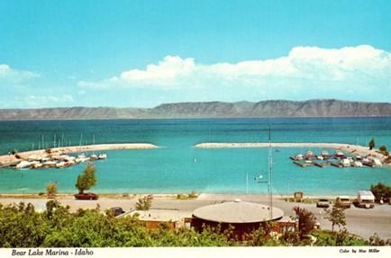
    <title type="html"><![CDATA[Bear Lake — Idaho-Utah]]></title>
    <summary type="html"><![CDATA[<p><strong><em>Along Idaho’s forty-five-mile portion of Highway 89, travelers pass Bear Lake, a natural freshwater body that spans the Utah and Idaho state lines. The lake’s vibrant blue waters have attracted travelers and locals to enjoy its outdoor recreation opportunities since the arrival of Euro-American settlers. Regular visitors have referred to Bear Lake as the “Caribbean of the Rockies,” due to its bright blue color. </em></strong></p><img src="https://www.intermountainhistories.org/files/fullsize/a2052eb33acb8a79b958725076cfb96f.jpg" alt="Bear Lake Marina Idaho Vintage Postcard Collectible Scenic View" /><br/><p><span>Long before Euro-American settlers found Bear Lake, the Bannock, Shoshone, and Ute tribes frequented the surrounding landscape for hunting. U.S. military officers John Fremont and Benjamin Bonneville surveyed this area in 1842. Their findings paved the way for Oregon Trail travelers, who later traversed around the lake en route to Oregon. During the late 19th century, Bear Lake was an informal outdoor recreation site, attracting tourists from across the American West to enjoy boating, camping, fishing, hunting, and swimming at the lake’s bright blue waters. </span>
<span>Multiple ambitious locals recognized the site’s popularity and chose to open resorts with lodging and dining. By 1926, several private resorts operated on Bear Lake’s shores, including Bear Lake Hot Springs, Fish Haven, Ideal Beach, Lakota, and Logan Canyon. In the following decades, some of these facilities expanded to offer indoor entertainment, such as rollerskating at Lakota Resort and dancing at Fish Haven Resort. Alongside outdoor recreation, Bear Lake’s various resorts became popular sites for large gatherings like family reunions and school field trips. During the early-mid 20th century, the Bear Lake resorts received higher volumes of tourists between June and August, leaving their lodging facilities with no vacancies. The Bear Lake resorts would experience increased patronage following the extension of Highway 89 from St. Charles, Utah, to Paris, Idaho, in 1956. These businesses advertised the lake’s accessibility to Salt Lake City residents who could reach their summer getaway via the highway without being too far from home.</span>
<span>Recognizing the site’s popularity, the Utah Bureau of Land Management declared Utah’s portion of Bear Lake a state park in 1962 with plans to expand the marina and harbor that year. In 1963, the Idaho State Land Board designated the lake’s northern shore as a state park. It was not uncommon for travelers en route to Yellowstone National Park to stop and behold the unexpected beauty of Bear Lake. The site grew to such popularity in the 1970s that the two state parks closed temporarily and considered ways to control the expanding crowds. Members of the Bear Lake County Commission and the State Parks Commission in each state considered charging overnight campers additional fees, enforcing a maximum capacity, and enforcing boat speed limits. While the state park directors strove to allow the maximum number of visitors to enjoy the beaches, they agreed that certain regulations were necessary to promote a quality experience for all.</span>
<span>Bear Lake continues to be a popular outdoor tourist destination along Highway 89 throughout the year. Spring and summer visitors can enjoy biking, bird-watching, boating, camping, swimming, and water skiing, while winter visitors enjoy ice fishing for the native Bonneville Cisco whitefish. This unique fishing opportunity has made the lake a popular attraction for such an activity, especially when the fish spawn near the lake’s icy shores in late January each year. Even if highway travelers do not plan to stop at Bear Lake, its vibrant blue waters offer a uniquely scenic view as they cruise by on Highway 89.</span></p><p><em><strong><a href="https://www.intermountainhistories.org/items/show/910">For more (including 5 images) view the original article</a></strong></em></p>]]></summary>
    <published>2025-09-23T15:38:24+00:00</published>
    <updated>2026-04-17T19:32:21+00:00</updated>
    <link rel="alternate" type="text/html" href="https://www.intermountainhistories.org/items/show/910"/>
    <id>https://www.intermountainhistories.org/items/show/910</id>
    <author>
      <name>Alexandra Williams, Northern Arizona University</name>
    </author>
  </entry>
  <entry>
    <title type="html"><![CDATA[Phil’s World, Cortez, CO: Follow Me, the Trails are Great]]></title>
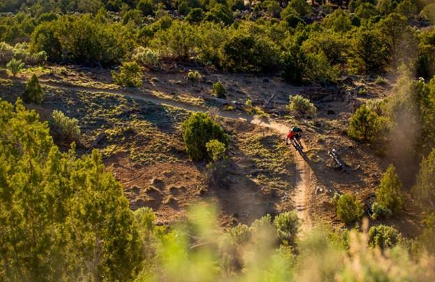
    <summary type="html"><![CDATA[<p><strong><em>Phil Vigil wanted little more than to explore. After relocating from Fairbanks, AK, to Cortez, CO, in the late 1980’s he found himself mountain biking on deer tracks and game trails across a seldom frequented patch of federal and state trust land five miles east of town. Despite his unexpected passing in 2020, his proclivity for route finding and engagement with the mountain biking community in Cortez have seen him remembered as the pioneer of one of the most renowned mountain bike trail networks on the Colorado Plateau. </em></strong></p><img src="https://www.intermountainhistories.org/files/fullsize/ef3252717c0ac23a2d1deb65ecc0bab9.jpg" alt="Mountain Biker Navigates Sweeping Right Turn, Sunset" /><br/><p>The state and federal trust land east of Cortez, CO, on which Phil’s World lies saw infrequent use into the late 1980’s with a small portion on the western half leased by a shooting range and the rest exploited or polluted through livestock grazing, firewood gathering, and illegal waste disposal. The sparse use and proximity to town did however offer enough seclusion for recent transplant Phil Vigil to trace deer tracks on his mountain bike across the undulating terrain. As the paths grew broader and more distinct, Vigil marked them with animal skulls and in-so-doing laid the groundwork for the trail system that came to bear his name.
In 1994, friends Jimbo Farley and Morgan Bell moved west from Alabama and opened Cortez’s only bike shop, Kokopelli Bike and Board. Vigil quickly became a regular. Phil’s tales of the paths near the shooting range prompted staff to nickname the area Phil’s World. Cortez local Scott Darling, then a teenager employed at the shop, was introduced to the trail system by Phil. Inspired, he and a small group of riders began to develop the network. While Phil had moved on to more remote country in the four corners region, builders like Bob Wright, Stephan Barnes, Sam Dayzie, and Shawn Gregory saw potential in the terrain and further established an engaging network unlike any other in the Southwest. Wright, Barnes, and Gregory prioritized ease, fun, and speed in their design and were advised by Dayzie, an indigenous amateur archaeologist, of conflicts in route finding with remnants of Ancestral Puebloan sites.
In the late 1990’s electricity supplier Tri-State Generation expressed interest in developing the land for coal production. While Tri-State pursued extractive access, the shooting range expanded its lease in October of 2003. Safety concerns citing repeated conflict between cyclists and target shooters and a lack of legal authority to build and maintain trail on the land placed Phil’s World in jeopardy. Advocacy groups Kokopelli Bike Club (now Southwest Colorado Cycling Association) and Greater Dolores Action filed a motion to lease 500 acres of state trust land and use adjacent Bureau of Land Management holdings to avoid conflict with gun enthusiasts with dual-members of the bike club and Four Corners Rifle and Pistol Club acting as mediating liaisons. By 2005, Tri-State Generation had shifted interest and the lease and funding for Phil’s World had been secured, mountain bikers were formally guaranteed land and resources.
To maintain the feeling of solitude for riders in the spirit of Phil’s original design, organizers established a directional loop system to minimize rider interaction and traffic. The clever layout, fast and fun trail building approach, and nearness to Cortez distinguished Phil’s as a prototype of the BLM’s Backyard to Backcountry project. The network’s revenue generating ability for Cortez and nearby Dolores, accessibility for all ability levels, and protection of sensitive resources made it a valuable asset to the BLM and encouraging example in cooperative land management for other Plateau communities.</p><p><em><strong><a href="https://www.intermountainhistories.org/items/show/907">For more (including 4 images) view the original article</a></strong></em></p>]]></summary>
    <published>2025-09-23T15:36:56+00:00</published>
    <updated>2026-04-17T19:32:20+00:00</updated>
    <link rel="alternate" type="text/html" href="https://www.intermountainhistories.org/items/show/907"/>
    <id>https://www.intermountainhistories.org/items/show/907</id>
    <author>
      <name>Nicholas Nation, Northern Arizona University </name>
    </author>
  </entry>
  <entry>
    <title type="html"><![CDATA[MEDL, Flagstaff, AZ: The People Want Trails]]></title>
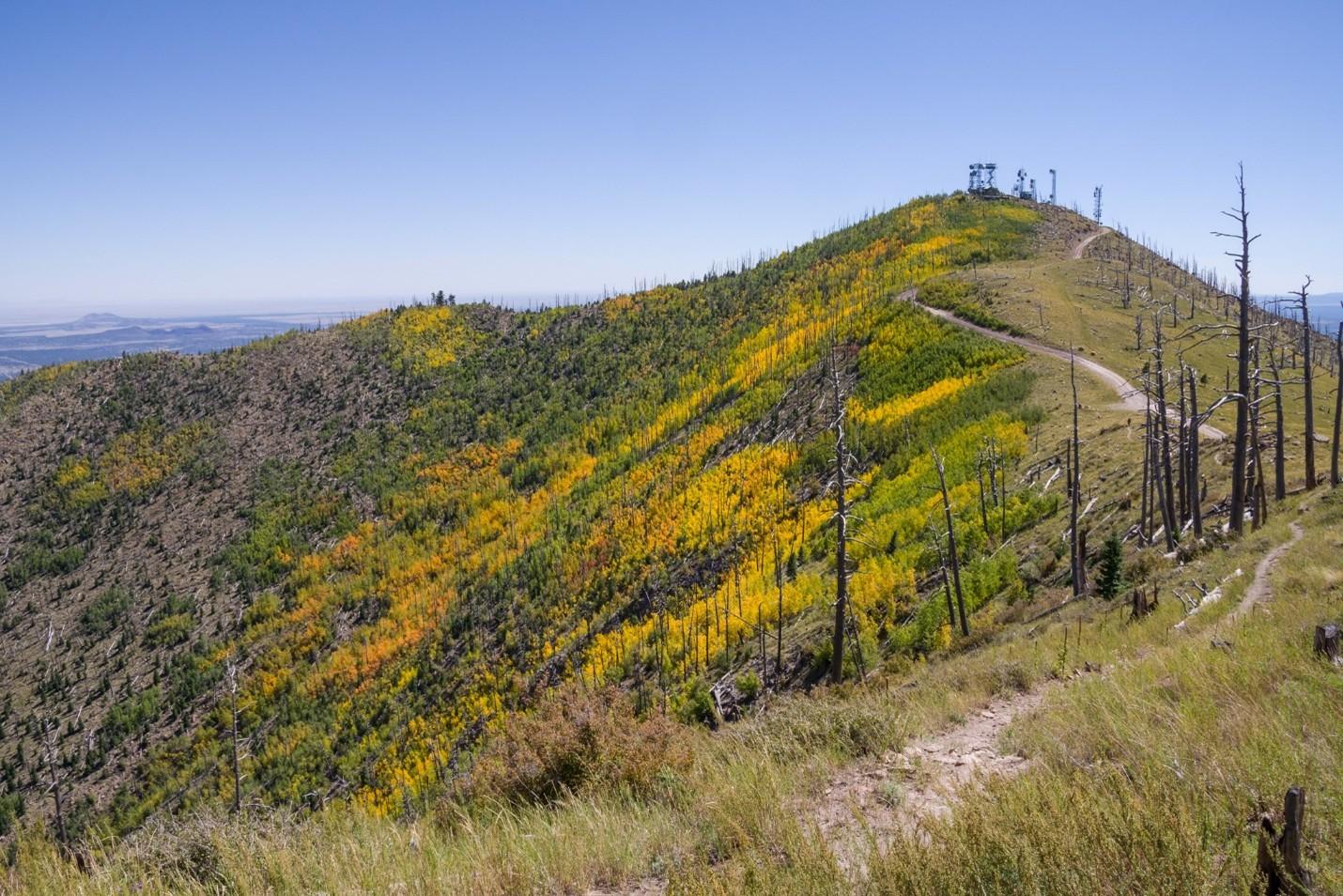
    <summary type="html"><![CDATA[<p><strong><em>The Mount Elden Dry Lake Hills trail system north of Flagstaff, AZ, traces its legacy of use closely with the history of the city. Dedicated in 1987, the network has steadily grown through community initiatives in cooperation with the Forest Service in Coconino National Forest to over 100 miles of trail. The proximity to town and rugged terrain give the illusion of a backcountry experience in an accessible frontcountry setting while the repurposing of game trails, sheepherding trails, fire breaks, and transportation lines maintains a connection to Flagstaff’s past.</em></strong></p><img src="https://www.intermountainhistories.org/files/fullsize/48b5ffa5c2b75a1821ff98ce917ee2a7.jpg" alt="Sunset Trail No. 23, Mount Elden" /><br/><p>As mountain biking developed around Marin County, CA, from the outfitting of WWII era “balloon tire” bikes with knobby tires and better brakes to more specialized equipment, two-wheeled recreation also began to take hold in the mountains and forests near Flagstaff, AZ. A local motorcycle club, the Coconino Motorcycle Trail Riders, connected remnants of the original Schultz Pass Road into a unified trail running up Schultz Creek in the 1970’s. When bicycle manufacturers began bringing bespoke mountain bikes to the market in the early 1980’s, Flagstaff’s existing cycling culture made for a quick uptake of the new machines. Mechanic Steve Garro of local shop Cosmic Cycles and the counterculture mountain bike racing team The Mutants joined other hobbyists to set about exploring the higher elevations accessible by Schultz Pass and Elden Lookout roads.
A series of disused wagon routes from the early 1900’s, old communications lines servicing the first lookout towers, fire breaks from the 1977 Radio Fire, and the plethora of livestock and game trails on the slopes were connected to unify the upper elevations of Mount Elden with the lower Dry Lake Hills to the west. As the trail network grew and diversified, so did the user base and rate of conflict. Many trails were closed to mountain bike access after unfavorable interactions with hikers and equestrians. After the forest service officially dedicated the Mount Elden Dry Lake Hills trail system in 1987, local advocacy groups successfully lobbied to restore mountain bike access and employed a code of conduct wherein cyclists were to yield to hikers or equestrians. 
As mountain bikes modernized into the 2000’s and usage expanded, MEDL supervisors recognized that mitigation of environmental damage induced by increased traffic was necessary. In 2006, the Flagstaff Bicycle Organization began advocating for directional downhill trails in the MEDL network to minimize hiker-biker interactions. Following the Schultz Fire in 2010, the forest service advanced a comprehensive trail planning scheme accounting for fire risk, endangered species protection, reduced user conflict, and local quality of life improvement. The proposed MEDL trail plan specifically focused on environmental protection and improved recreational access for residents over tourism.
Though delayed by thoughtful debate with groups like the Sierra Club, and the Museum Fire in 2019 that burned existing paths and planned expansion, the realignment of several traverses on erosive slopes in 2020 proved the venture worthwhile. The subsequent effort between the forest service and volunteer mountain bike, trail running, and motorcycle groups to professionally mark and build sustainable routes across the MEDL network garnered community support. The ongoing project has improved or created over twenty-five miles of trail since 2022 including the first sanctioned, directional mountain bike trails in Flagstaff – called Meteoride and Full Sail. The city’s assets in the sciences and passionate volunteer advocacy groups have allowed for thorough planning in current and future trail building that is as mindful of the protection of the mountain’s fragile ecology as it is of the improved quality of life that outdoor recreation can bring the community.  </p><p><em><strong><a href="https://www.intermountainhistories.org/items/show/906">For more (including 4 images) view the original article</a></strong></em></p>]]></summary>
    <published>2025-09-23T15:36:55+00:00</published>
    <updated>2026-04-17T19:32:20+00:00</updated>
    <link rel="alternate" type="text/html" href="https://www.intermountainhistories.org/items/show/906"/>
    <id>https://www.intermountainhistories.org/items/show/906</id>
    <author>
      <name>Nicholas Nation, Northern Arizona University </name>
    </author>
  </entry>
  <entry>
    <title type="html"><![CDATA[Kokopelli’s Trail, Loma, CO: In Pursuit of Solitude]]></title>
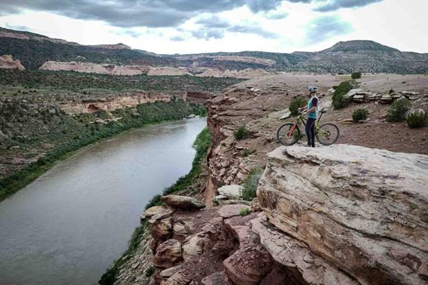
    <summary type="html"><![CDATA[<p><strong><em>Stretching 142 miles between Loma, CO, and Moab, UT, Kokopelli’s Trail is one of the earliest publicized examples of a backcountry mountain biking route. The unification of Kokopelli’s in 1989 by the Colorado Plateau Mountain Bike Trail Association helped popularize a new brand of distance cycling – bikepacking - and inadvertently made the American Southwest one of the best-known bikepacking destinations in the world. </em></strong></p><img src="https://www.intermountainhistories.org/files/fullsize/ec7c7c9ba0710082ba17aaf9f08f0443.jpg" alt="View of Kokopelli Trail Grand Junction" /><br/><p>When mountain bikes became commercially available in the early 1980’s, wealthy baby boomers from coastal California began to explore the west on their new machines enticed by the vast landscapes and inexpensive accommodation. Moabites recognized the economic opportunity afforded by mountain bike tourism and by the late 1980’s Moab, UT, had become a premier cycling destination. While the highly publicized Slickrock Trail was leveraged to draw visitors in, the vast network of 4x4 roads surrounding the town, relics of a defunct uranium industry, began to see increased use among cyclists. Nearby Grand Junction, CO, was experiencing similar backcountry traffic in the late 1980’s. Grand Junction Bureau of Land Management officials observed illegal mountain bike use in the Black Ridges Wilderness Study Area threatening to undermine ecological research. BLM area manager John Singlaub sought to protect the wilderness without alienating cyclists and proposed BLM recreation planner Carlos Sauvage build a cycling route on non-wilderness lands along the Colorado River. Lacking funding, the BLM turned to mountain biker and Grand Junction lawyer Timms Fowler to help plan and coordinate the effort. Long dreaming of a unified route across the remote region, Fowler jumped at the opportunity to aid in the construction.
Beginning in November of 1988, Sauvage and other BLM personnel began driving and mapping the dozens of dirt roads abandoned by the uranium industry between the route’s planned start point in Loma, CO, and terminus in Moab, UT. Meanwhile, Fowler set up meetings with bike shops in Grand Junction and Moab to secure volunteer support for the project. After identifying a course on 4wd tracks, BLM workers planned ten additional miles of singletrack trail to access scenic vistas and ensure an engaging riding experience. A volunteer building effort commenced in the spring of 1989 under the newly formed Colorado Plateau Mountain Bike Trail Association and after six weekends of construction, the 142 mile long Kokopelli’s Trail was completed. On May 6<sup>th</sup>, 1989, the Hopi Flute Clan for whom the trail was named held a ceremony under elder Ebin Leslie in Cisco, UT, the halfway point, to officially open Kokopelli’s to the public.  
Kokopelli’s quickly generated interest among mountain bikers. The high level of community engagement guaranteed considerable public awareness of the project and increased ridership. Proximity to major throughfares like Interstate 70 and Highway 191 made for easy access to the trail. The federal officiating in route creation and surveying resulted in an abundance of maps and backcountry planning resources for prospective users. The trail’s position on BLM land made it popular among bikepackers, backcountry cyclists who pursue multi-day, self-supported rides, because of the relaxed camping regulations imposed on remote public lands. The vastness of the landscape Kokopelli’s Trail traverses and the solitude afforded by its 142 miles in length made for an experience difficult to capture elsewhere and secured the Southwest as a stronghold for backcountry mountain biking.</p><p><em><strong><a href="https://www.intermountainhistories.org/items/show/905">For more (including 3 images) view the original article</a></strong></em></p>]]></summary>
    <published>2025-09-23T15:36:54+00:00</published>
    <updated>2026-04-17T19:32:20+00:00</updated>
    <link rel="alternate" type="text/html" href="https://www.intermountainhistories.org/items/show/905"/>
    <id>https://www.intermountainhistories.org/items/show/905</id>
    <author>
      <name>Nicholas Nation, Northern Arizona University </name>
    </author>
  </entry>
  <entry>
    <title type="html"><![CDATA[Gooseberry Mesa National Recreation Trail, Hurricane, UT: We Can Ride Too]]></title>
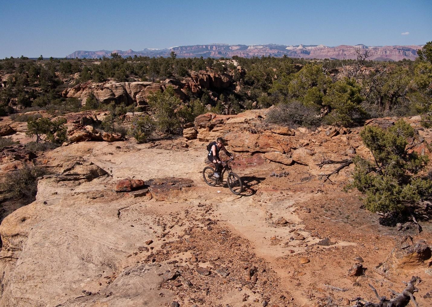
    <summary type="html"><![CDATA[<p><strong><em>After Mike and Morgan Harris started building the trail system now called Gooseberry Mesa National Recreation Trail in the early 1990’s, they had no idea it would become such a significant attraction to the mountain biking community. Situated eight and a half miles from Hurricane, Utah, and twenty miles southwest of Zion National Park, “The Goose” as it’s affectionately known is one of the most scenic riding centers on the Colorado Plateau.  </em></strong></p><img src="https://www.intermountainhistories.org/files/fullsize/7071445632eb7a04a4404768333d12d1.jpg" alt="Harris Secret Trail" /><br/><p>When Mike and Morgan Harris relocated to Hurricane, UT, in the early 1960’s, Gooseberry Mesa was a seldom frequented parcel allocated to the Bureau of Land Management that remained unused on account of the tight, maze-like topography. The water holding capacity of the rock that caps the mesa, Shinarump conglomerate, enables an ecology with pockets of lush vegetation frequented by game populations. The Harris’ early exploration of the mesa was as a hunting ground. Their use of motorcycles and frequent hikes through the formation gave them an intimate knowledge of the landscape and route-finding abilities that others lacked.
While the Harris’s were hunting the mesa, mountain biking had slowly been moving into the rural West. The fledgling sport originated in the late 1960’s in Marin County, CA, when a group of teens started riding single-speed “balloon tire” bikes up and down Mt. Tamalpais. After noticing cycling clubs optimizing old bikes for offroad races in the 1970’s, major manufacturers developed consumer market bicycles for the harsher settings mountain bikers were riding in the early 1980’s. Enticed by the new trend and cheap, rural accommodation, wealthy baby-boomers bought in and began to explore the Colorado Plateau. Moab’s Slickrock Trail came to be the pinnacle mountain biking destination in the late 1980’s and after a visit in 1993, Mike and Morgan realized their secluded hunting ground would be an ideal venue to develop deliberate mountain bike paths.
Upon returning from Moab, the Harris’ scouted and marked a primitive trail network across the twenty-four square miles of Gooseberry Mesa. Their approach attempted to fully immerse riders in the terrain by utilizing the entirety of the landscape. Though both were inexperienced riders and still honing their skills, their recognition that mountain biking equipment was consistently improving lead them to pursue increasingly challenging obstacles. They offered the spectacular scenery afforded by the mesa’s 2000 feet of prominence over the badlands below as a reward for each completed section. While their Gooseberry trails lacked the elevation gain and loss of Slickrock in Moab, they engaged mountain bikers by keeping difficult trail features like near vertical ascents and descents hidden around corners or behind foliage affording little time to prepare for each challenge. The construction style they helped popularize made riding acumen more important than quality of gear earning popularity among hobbyists and professionals alike.
After hearing that other builders were fined for similar unsanctioned work, the brothers turned themselves in to the BLM and facilitated a visit with federal officials to the mesa. To their surprise, BLM personnel were so impressed with the work that measures were taken to officially adopt the tracks resulting in their designation as the first official mountain biking trails in Washington County, Utah, on October 26<sup>th</sup>, 1999. Seven years later in 2006 the routes were upgraded to National Recreation Trail status by the BLM, an accolade that demonstrates a commitment to continued use, sustainable environmental practice, and an anticipated increase in tourism for the surrounding communities.</p><p><em><strong><a href="https://www.intermountainhistories.org/items/show/904">For more (including 3 images) view the original article</a></strong></em></p>]]></summary>
    <published>2025-09-23T15:36:54+00:00</published>
    <updated>2026-04-17T19:32:20+00:00</updated>
    <link rel="alternate" type="text/html" href="https://www.intermountainhistories.org/items/show/904"/>
    <id>https://www.intermountainhistories.org/items/show/904</id>
    <author>
      <name>Nicholas Nation, Northern Arizona University </name>
    </author>
  </entry>
  <entry>
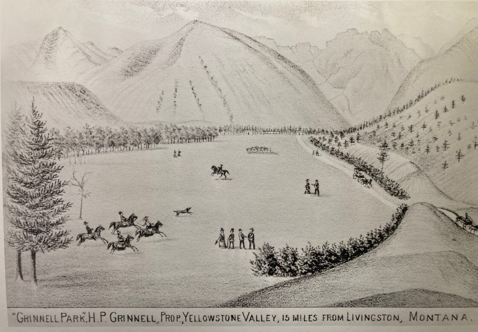
    <title type="html"><![CDATA[The Founding of Luccock Park Camp]]></title>
    <summary type="html"><![CDATA[<p><strong><em>After World War 1, a group of Methodists in Livingston, Montana planned to build a summer camp near Yellowstone Park. They travelled 15 miles outside Livingston in buckboard wagons through 2-3 feet of snow to a potential location for this camp, Grinnell Park. Arriving at Grinnell Park, the Methodists knew that they had found the perfect place for a summer camp.</em></strong></p><img src="https://www.intermountainhistories.org/files/fullsize/3cf3158003ddbe0be98bbbc2cb654fab.jpg" alt="Sketch of Grinnell Park" /><br/><p>In the summer of 1919, the Methodist Epworth League in Montana wanted to join the growing trend of church camps that started after World War I. At a conference in Billings, they decided to create a camp about 30 miles north of Helena at Wolf Creek. The Wolf Creek camp was a hit, so the Epworth League decided to build more camps in Montana. Four years later on, a district missionary conference convened in Livingston to build a camp near Yellowstone Park. They decided to investigate Grinnell Park, a glacially-formed valley about 15 miles south of Livingston near Pine Creek as a potential site for this camp. </p><p>On March 11, 1923, a group consisting of Epworth League members, conference members, and Albert Alan, the owner of the land, traveled to Grinnell Park in 3-seated buckboard wagons, fighting against 2-3 feet of snow. The Methodists fell in love with the area and swiftly authorized the Livingston conference to “proceed with all necessary arrangements” to use Grinnell Park as the location for a church camp. Alan sold the land, which was about 25 acres “more or less” for $2,500. Pastor Otto G. Ponath of the local Pine Creek Church helped to build a road up to the camp that was determined to be about a $6,000 job by the highway department. With this road, a Model-T Ford was “driven, pushed, and pulled up to the camp” and both guests and staff were able to travel to the camp. Using old Ringling Circus tents from Billings, members of the state convention were able to make important decisions while being protected from an oncoming storm. One of these decisions was naming the camp “Luccock Park” after the first resident Bishop of Helena, Naphtali Luccock. They also decided to name the mountains that surround the camp from left to right, Faith, Hope, and Charity. </p><p>One hundred years later, Luccock Park still stands as a place for people to gather. It has survived extreme weather, a wildfire that almost burned down the camp, and a global pandemic. There are now permanent buildings on site: the main lodge, an old ranger’s station, a chapel, multiple bathhouses, and dozens of cabins. The camp is open from mid-May to mid-September, hosting a number of Methodist camps, weddings, group getaways, and so much more. In the summer of 2023, a celebration was held to celebrate the last 100 years of Luccock Park. People from all over the country came together at Luccock Park to celebrate and talk about the past and their hopes for the future of the camp.</p><p><em><strong><a href="https://www.intermountainhistories.org/items/show/865">For more (including 4 images) view the original article</a></strong></em></p>]]></summary>
    <published>2024-10-19T00:58:26+00:00</published>
    <updated>2026-04-17T19:32:19+00:00</updated>
    <link rel="alternate" type="text/html" href="https://www.intermountainhistories.org/items/show/865"/>
    <id>https://www.intermountainhistories.org/items/show/865</id>
    <author>
      <name>Alyssa Ulrickson, Rocky Mountain College</name>
    </author>
  </entry>
  <entry>
    <title type="html"><![CDATA[Dookó’oslííd: San Francisco Peaks]]></title>
    <summary type="html"><![CDATA[<p><strong><em>The San Francisco Mountains have been sacred to many Indigenous peoples for centuries. Competing land-use approaches have resulted in conflict and court battles.</em></strong></p><img src="https://www.intermountainhistories.org/files/fullsize/2d0a9632ef2c9302b5c371c74f1cca0d.jpg" alt="Ski Lift at the Arizona Snowbowl. " /><br/><p>The San Francisco Mountains are located ten miles north of present-day Flagstaff, Arizona and include Humphreys Peak, the tallest in the state. Formed as a stratovolcano from 2.8 million to 200,000 years ago, erosion eventually carved the eastern side of the rim away, leaving a semi-circular ridge line of peaks that rise above the timberline. The range includes the San Francisco Volcanic Field, which covers about 1,800 square miles in northern Arizona. </p><p>The mountain peaks hold sacred significance for thirteen Indigenous nations in the Southwest, including the Diné (Navajo), Hualapai, Hopi, Southern Paiute, Havasupai, Yavapai, Zuni, Acoma, and several Apache tribes. The Diné regard the San Francisco peaks (Dookó’oslííd in Diné) as the western boundary of Dinetah, or Navajo homeland. For the Diné, the sacred peaks connect cosmology to the physical world and spiritual power to their people. In traditional Diné culture, the peaks were created by First Man and imbued with an inner spiritual form known as bii’istiin. Each of the sacred boundary mountains has an associated color full of history and significance, such as yellow for the San Francisco mountains.</p><p>The peaks not only occupy a central place in cosmological narratives, they also play a vital role in medicinal and ceremonial practices in daily life. The mountains’ spiritual nature requires that they can only be ascended in a respectful way that includes prayer and song. Healers visit the mountains to collect soil and materials for medicine bundles, and to renew spiritual powers. Diné spiritual leaders regularly invoke the powers of the mountains in ceremonies across Dinetah.</p><p>The spiritual significance that the San Francisco mountains have for the Diné and other Indigenous peoples collide with Euro-American approaches to the land. In the 1800s American settlers began grazing livestock on the mountains’ slopes, including the Mormon-run cattle company at Fort Moroni. In 1908, Theodore Roosevelt designated the peaks as National Forest land and, in 1920, a Flagstaff entrepreneur began building a road to the top of the peaks for tourists. In 1938, the Forest Service leased land to entrepreneurs who created a ski resort called the Arizona Snowbowl, which has been in operation ever since. </p><p>An ongoing controversy began in 2002 when the Snowbowl announced plans to expand the resort and create artificial snow using reclaimed wastewater. After years of pushback, a 2007 court of appeals ruled in favor of the Diné who sued the Forest Service over using reclaimed water. The court reversed their religious rights decision a year later. In 2012, an appeals court ruled in favor of the resort against the wishes of the Hopis, and artificial snowmaking commenced. In 2022, after years of snowmaking, a proposed 60 millionaire dollar expansion led to increased tribal resistance that is presently ongoing. </p><p><em><strong><a href="https://www.intermountainhistories.org/items/show/847">For more (including 2 images) view the original article</a></strong></em></p>]]></summary>
    <published>2024-09-21T06:01:37+00:00</published>
    <updated>2026-04-17T19:32:19+00:00</updated>
    <link rel="alternate" type="text/html" href="https://www.intermountainhistories.org/items/show/847"/>
    <id>https://www.intermountainhistories.org/items/show/847</id>
    <author>
      <name>George Smith, Brigham Young University</name>
    </author>
  </entry>
  <entry>
    <title type="html"><![CDATA[Kiva Beach: The Hidden Jewel of Lake Tahoe]]></title>
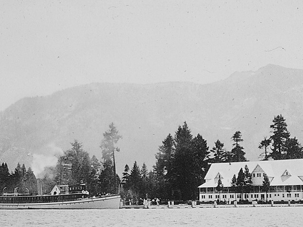
    <summary type="html"><![CDATA[<p><strong><em>Home to the Washoe Tribe, Kiva Beach on Lake Tahoe once had a luxurious beach resort along its shores which is now known as the Tallac Historic Site.</em></strong></p><img src="https://www.intermountainhistories.org/files/fullsize/18ccb87d120320af49769ab379cf98f4.jpg" alt="Tallac Resort and Casino with SS Tahoe on the lefthand side of the photo, ca. 1899-1920" /><br/><p>Kiva Beach on the southern shore of Lake Tahoe attracts thousands of visitors annually who seek a beach vacation and historic interpretation provided by the Tallac Historic Site.</p><p>Visitors enjoy swimming and sunbathing, and although there is no boat launch, people are welcome to bring their personal kayaks or paddle boards. Parking is free and the beach is also accessible by the Pope Baldwin Bike Path. The forest trail to the beach offers historical interpretation, including signs along the path that describe vegetation and local history. This beach is often less crowded than others around Lake Tahoe and provides picnic tables for people to sit at and enjoy the view of Maggie’s South Peaks in the distance.</p><p>The Washoe Tribe calls the region of Lake Tahoe their home, and Kiva Beach got its name after the traditional Indigenous kiva, which is a ceremonial structure. The lake provided life-sustaining water for the Washoe and each family had its own fishing grounds along the shorelines. While the tribe is still around today, they no longer reside near Lake Tahoe due to European settlement in the 19th century and contemporary tourism. The Washoe people continue to lobby for their rights to their homeland in the Lake Tahoe Basin.</p><p>The first settler at Lake Tahoe was John C. Fremont, explorer and politician, in 1844. However, it was not until 1859 that other European settlers started to pay attention to the area for its mining potential. Silver mining opportunities and the completion of the Central Pacific Railroad in 1869 brought people to settle around Lake Tahoe. One settler, Ephraim Clement, built the Tallac Point House located on Kiva Beach in the early 1870s. In 1880, Elias Baldwin bought the property and began to turn it into a luxurious beach resort complete with steamboat rides for guests. Baldwin added a second building called the Tallac Hotel, revered as “the grandest in all the world,” in 1899. These hotels allowed for high-end beach living on Lake Tahoe as only wealthy guests could afford to stay at Tallac Point. After the outbreak of World War I, tourism slowed in 1914 the Tallac House burned down, and the Tallac Hotel was razed in the 1920s.  The land went through multiple family owners until the Baldwin descendants sold the land to the Forest Service in 1969. The interpretive museum opened in 1990 where they give guided tours of the remaining buildings.</p><p>In 2011, Kiva Beach became a popular place for spiritual yoga practice. Attendees can participate in a yoga class on the sandy shores and then take an optional “cold plunge” in the lake. Beachgoers recommend this beach for dog owners since it is one of the few dog-friendly beaches on the lake. Kiva Beach is also family-friendly due to its secluded nature and the prohibition of alcohol on its shores. People continue to visit peaceful Kiva Beach as it allows guests to experience the best of both worlds, with both snowy mountains and a sandy beach.</p><p><em><strong><a href="https://www.intermountainhistories.org/items/show/846">For more (including 3 images) view the original article</a></strong></em></p>]]></summary>
    <published>2024-09-03T19:42:25+00:00</published>
    <updated>2026-04-17T19:32:19+00:00</updated>
    <link rel="alternate" type="text/html" href="https://www.intermountainhistories.org/items/show/846"/>
    <id>https://www.intermountainhistories.org/items/show/846</id>
    <author>
      <name>Olivia Hall, Northern Arizona University</name>
    </author>
  </entry>
  <entry>
    <title type="html"><![CDATA[Keyhole Beach: The Key to Beach Life]]></title>
    <summary type="html"><![CDATA[<p><strong><em>The "key" to beach life in Wyoming can be found at Keyhole Beach. The land originally belonged to the Sioux, however, the U.S. government claimed it in 1877 and the beach was later created by the reservoir behind Keyhole Dam in 1952.</em></strong></p><img src="https://www.intermountainhistories.org/files/fullsize/a1198626791a7dda71da4448f593c7fd.jpg" alt="Keyhole Reservoir, 2008" /><br/><p>Located on the southeast shore of Keyhole Reservoir, Keyhole Beach is hailed for its fishing opportunities and as a “mecca” for bird-watching with about 225 species to see. Along with catching one of Wyoming’s largest fish, a freshwater drum, beachgoers can enjoy swimming, boating, kayaking, paddleboarding, sunbathing, and waterskiing. The closest campground is called Tatanka, after the Lakota word for “buffalo.” Tatanka Campground has the best selection of amenities in the area, including water and electric hookups for RVs and rentable cabins, as well as picnic tables at Tatanka, a marina, and a boat launch on the beach. </p><p>The Sioux inhabited and controlled the area long before the Bureau of Reclamation completed Keyhole Dam in 1952, and they continue to fight for this right today. In the Ft. Laramie Treaty of 1868, the U.S. recognized the tribe's ownership of the Black Hills territory which included the Šahíyela Wakpá River (also known as the Belle Fourche River). Named by French fur traders in the 1780s, Bella Fourche means “beautiful fork.” As miners illegally entered the territory throughout the 1870s, the settlers and the Sioux continued to have disputes about the ownership of the territory, and after the defeat of Custer at Little Bighorn, the U.S. waged war on the Sioux and then confiscated their land in 1877. While offered monetary compensation for the land grab after the 1980 Supreme Court case United States v. Sioux Nation of Indians, the Sioux believed this was an insufficient settlement and declined the money. The dispute over land ownership, and the Sioux’s claim on it, continues today. </p><p>As the gold rush persisted in the Black Hills more settlers moved in and in 1891 the Chicago and Northwestern Railroad entered the town of Belle Fourche, seventy-three miles to the northeast. The community became a livestock shipping hub and the name of Keyhole Reservoir derives from the livestock brand the McKean brothers used at their nearby ranch. The Bureau of Reclamation proposed the dam as a part of the Belle Fourche Project, started in 1904, which irrigated lands in the area. While ranchers protested the dam in 1950 due to their loss of farming land, the benefits of wildlife conservation, flood control, and recreational opportunities outweighed their concerns. </p><p>With the completion of the dam in 1952, beach life started to take off at Keyhole Reservoir with the creation of Keyhole State Park. In 1984, the Keyhole Expo was a county fair on the beach's shores that included hot air balloon racing, windsurfing, and more. In 1989, the State Park expanded upon the fair as a part of Wyoming State Park’s “Summerfest.” This event included boat rides to discover the beauty of Keyhole Reservoir, arts and crafts booths, and food concessions. </p><p>Today, Keyhole Beach hosts events such as a Lantern Fest where beachgoers can release floating lanterns on the reservoir and witness the illumination of the lake. Keyhole Marina also contains a bar and grill where visitors can eat and listen to live music on the beach. The community-oriented marina and campgrounds paired with scenic views make Keyhole Beach a memorable vacation spot.</p><p><em><strong><a href="https://www.intermountainhistories.org/items/show/845">For more (including 3 images) view the original article</a></strong></em></p>]]></summary>
    <published>2024-09-03T19:39:03+00:00</published>
    <updated>2026-04-17T19:32:19+00:00</updated>
    <link rel="alternate" type="text/html" href="https://www.intermountainhistories.org/items/show/845"/>
    <id>https://www.intermountainhistories.org/items/show/845</id>
    <author>
      <name>Olivia Hall, Northern Arizona University</name>
    </author>
  </entry>
  <entry>
    <title type="html"><![CDATA[The History of Sundance]]></title>
    <summary type="html"><![CDATA[<p><strong><em><span style="font-weight:400;">Sundance, Utah is a small resort in the North Fork of Provo Canyon that has a rich history, particularly within its ownership. The area was originally populated by members of the Ute nation. It then passed into the hands of the Stewart family who arrived with the Latter-day Saints. Most recently it has been the site of a ski resort owned and operated by Hollywood actor Robert Redford. </span></em></strong></p><img src="https://www.intermountainhistories.org/files/fullsize/70ba18fee03d691bf08a4bb9fb530537.jpg" alt="Sundance from Stewarts Cascades Trail, Jun 16" /><br/><p><span style="font-weight:400;">Nestled in Provo Canyon, what is known today as Sundance has a rich history that reflects the different eras of Utah settlement. The land was occupied by the Ute nation beginning in 1,400 AD. Sundance was in an area where the Utes would visit in the summer to enjoy the cool mountain temperatures and lush forests filled with game. The arrival of Latter-day Saint pioneers pushed the Utes out of the area, leaving Sundance to be settled by the Stewart family. </span>
<span style="font-weight:400;">The Stewarts were Scottish immigrants that came to Utah in the mid-1800s. Andrew Jackson Stewart Jr. and his sons surveyed land in Provo Canyon and felt particularly drawn to the area. Through the Homestead Act of 1862, the Stewarts were each able to secure 160 acres of land within the canyon. Other families joined them, and by 1911, there were 2,200 acres of settled land in the North Fork of Provo Canyon that were then known as Stewart Flats. </span>
<span style="font-weight:400;">Stewart Flats began to be recognized for its recreational draw in the 1930s and 40s. In 1944, S. Paul Stewart and his brother and sister-in-law Ray and Ava Stewart opened up Timp Haven, a small ski area that operated for 20 years. Timp Haven was greeted by a noteworthy guest in the 1950s when Hollywood actor Robert Redford accidentally stumbled on the area due to a miscalculated turn on a road trip through the West. </span>
<span style="font-weight:400;">Redford purchased a sizable portion of the Stewart family land in 1969 and renamed the area Sundance, after his character in the western film </span><i><span style="font-weight:400;">Butch Cassidy and the Sundance Kid</span></i><span style="font-weight:400;">. According to Redford, one of his major goals for Sundance was “to develop a little and preserve a great deal.” Instead of succumbing to overdevelopment with hotels and condominiums, Redford’s focus at Sundance was environmental conservation and the promotion of the arts. </span>
<span style="font-weight:400;">In 1978 Redford increased his Utah presence by founding the Sundance Film Festival, held annually in Park City, building on his Sundance legacy. In 2020, Redford sold 2,600 acres, including the Sundance Mountain Resort, to Broadreach Capital Partners and Cedar Capital Partners with an agreement that they would continue Sundance’s pursuit of environmental preservation and conscientious development. </span></p><p><em><strong><a href="https://www.intermountainhistories.org/items/show/789">For more (including 4 images) view the original article</a></strong></em></p>]]></summary>
    <published>2024-03-03T03:43:20+00:00</published>
    <updated>2026-04-17T19:32:17+00:00</updated>
    <link rel="alternate" type="text/html" href="https://www.intermountainhistories.org/items/show/789"/>
    <id>https://www.intermountainhistories.org/items/show/789</id>
    <author>
      <name>Britain Schwarz, Brigham Young University</name>
    </author>
  </entry>
  <entry>
    <title type="html"><![CDATA[Lagoon&#039;s Patio Gardens]]></title>
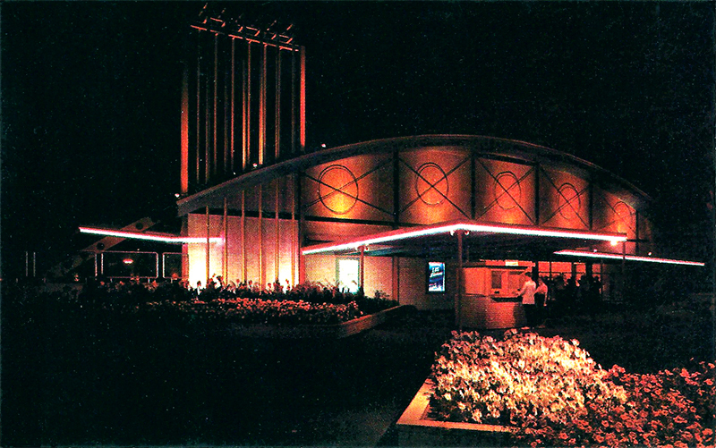
    <summary type="html"><![CDATA[<p><strong><em><span style="font-weight:400;">Utah’s Lagoon used to be more than just an amusement park; it once housed a large concert venue within its gates, hosting many performances by music legends from the 1950s to the early 1970s.</span></em></strong></p><img src="https://www.intermountainhistories.org/files/fullsize/22bf785d177cfc260f8fabc152cf11d6.jpg" alt="Postcard of Patio Gardens" /><br/><p><span style="font-weight:400;">In 1953 a fire tore throughout Lagoon, Utah’s only amusement park, and destroyed many buildings there. Then owner, Robert Freed, saw this as an opportunity to update the architecture of the park to something much more modern–to create the “New Lagoon.” One of the buildings constructed during the renovations was the Patio Gardens, a concert venue to replace an old, ruined Dancing Pavilion. While Lagoon had live performances before the 1950s, Patio Gardens, with its stage and dance floor, became the new house for concerts. The performances in Patio Gardens over the next two decades included some of the most popular national artists and would make Lagoon nationally known, especially within the 1960s counterculture music scene. </span>
<span style="font-weight:400;">One such popular group was the Beach Boys who, on September 7, 1963, thrilled their youthful Utah audience with their song “Salt Lake City,” claiming that Salt Lake City had “the grooviest kids.” The Beach Boys returned to Lagoon again and again with their final performance of fourteen appearances taking place on September 12, 1970.</span>
<span style="font-weight:400;">The Beach Boys were just one of many popular groups that performed at Patio Gardens. Other notable counterculture bands such as The Rolling Stones, The Monkees, The Who, Janis Joplin, and Jefferson Airplane also performed there. Even The Beatles were in discussions to perform at Lagoon, but their high asking price led to their exclusion. Patio Gardens also housed more classic acts, such as Benny Goodman, the Utah Symphony, and Ella Fitzgerald. </span>
<span style="font-weight:400;">Most bands had a good experience, with some even returning to perform again or immortalizing the venue in songs, as the Beach Boys did. However, there were also bands who hated the venue and, more importantly, the crowds. On May 25, 1968, The Doors performed to a crowd of about 3,500, nearing the venue’s 4,000-person capacity limit. Jim Morrison, the band’s lead singer, declared that the crowd was dead for his first performance of the day, hurled vulgar insults to the audience, and after three songs walked off of the stage, never to return. </span>
<span style="font-weight:400;">Regardless of the failure of The Doors concert, Patio Gardens is remembered fondly by many Utahns. Patio Gardens closed in 1973 after operating for twenty years. Where music legends used to perform is now the home of the dark ride Dracula’s Castle and Lagoon’s arcade. The original light fixtures and the top of the stage (the rest of which is hidden by a wall) are the only reminders of what helped make Lagoon so famous.</span></p><p><em><strong><a href="https://www.intermountainhistories.org/items/show/778">For more (including 3 images) view the original article</a></strong></em></p>]]></summary>
    <published>2024-02-22T22:07:05+00:00</published>
    <updated>2026-04-17T19:32:17+00:00</updated>
    <link rel="alternate" type="text/html" href="https://www.intermountainhistories.org/items/show/778"/>
    <id>https://www.intermountainhistories.org/items/show/778</id>
    <author>
      <name>Mikelle Andersen, Brigham Young University</name>
    </author>
  </entry>
  <entry>
    <title type="html"><![CDATA[Malan Heights Resort]]></title>
    <summary type="html"><![CDATA[<p><strong><em>In 1894, Bartholomew Malan built a hotel atop a peak along the mountains in Ogden, Utah. The hotel, named Malan Heights Resort, offered spectacular views and excellent service for its guests. Although Malan Heights Resort burned down after only a few years in operation, visitors today can see an old boiler and a plaque to remember this hotel.</em></strong></p><img src="https://www.intermountainhistories.org/files/fullsize/9b9eda4847cf74190d4eda6b1add0b1a.jpg" alt="Sunset on Malan&#039;s Peak" /><br/><p><span style="font-weight:400;">Bartholomew “Tim” Malan (1848-1913) came from a family of Italian immigrants that moved to Ogden when he was seven years old. In 1891, Malan purchased roughly 800 acres of land and began constructing a road up Taylor’s Canyon. The road led up the south part of the canyon and reached a basin at the peak of the mountain. Malan began building a hotel, which he called the Malan Heights Resort when it was finished in 1894. The nearby peak and basin also carry Malan’s name. A newspaper article, published August 20, 1895, reported, “B. Malan has now completed a road to Waterfall Canyon and is prepared to accommodate any number of pleasure seekers.” Another article noted that “he has succeeded in carrying out his plans done well.” Malan offered transportation services up the mountain at a cost of one dollar for a round-trip. One of the primary attractions of Malan Heights Resort was the view of the valley from the top of the mountain. </span>
<span style="font-weight:400;">Tourists’ responses to Malan Heights Resort were overwhelmingly positive. Visitors were quick to note the beauty and grandeur of the mountain scenery. One tourist, Mrs. L.L. Rogers, exclaimed, “To say the scenery is grand, grand, my pen only feebly conveys the idea. One needs take the trip to fully realize and appreciate the grandeur of the affair.” An Ogden Daily Standard article reported that “the visitors exclaim that they never saw anything like the mountain scenery of the Wasatch range.” The mountains surrounding Malan Heights Resort provided stunning views that created an enjoyable environment for tourists. The resort offered such a refreshing experience for visitors that it could be compared to a “Copacabana of the West.” Malan chose a strategic location for his hotel, as tourists could enjoy both the hotel’s services and the extraordinary landscape. For the years the hotel was in operation, guests were treated to a prime vacation spot in the mountains. </span>
<span style="font-weight:400;">Despite the beautiful backdrop, the hotel faced some unfavorable circumstances, including vandalism and property damage. According to an </span><i><span style="font-weight:400;">Ogden Daily Standard</span></i><span style="font-weight:400;"> article, “visitors have pulled stones down from the sidewalls which protect the road” and “others have taken a delight in hurling stones from the wall down the mountain side, endangering the lives of those who might be walking below.” Malan created a ten-cent toll on traveling to the hotel to make up for the destruction, but was ultimately unsuccessful in reversing the hotel’s prospects. The hotel permanently closed in 1904, and in 1910, it burned down due to a forest fire. All that remains today is an old boiler and a memorial plaque that sits in the basin to inform visitors about the resort. </span>
<span style="font-weight:400;">Today, visitors can still enjoy the breathtaking landscapes and hike Malan’s Peak and Malan’s Basin. After hiking through Taylor Canyon, visitors arrive at a sign with instructions to cross the bridge and start the switchbacks up Malan’s Peak. After reaching the Peak, one can continue on to Malan’s Basin concluding their hike after 2-3 hours with a total of 6.8 miles roundtrip. While the hotel may be gone, the scenery endures as testament to Malan’s vision of western grandeur.</span></p><p><em><strong><a href="https://www.intermountainhistories.org/items/show/741">For more (including 3 images) view the original article</a></strong></em></p>]]></summary>
    <published>2023-04-07T19:58:15+00:00</published>
    <updated>2026-04-17T19:32:16+00:00</updated>
    <link rel="alternate" type="text/html" href="https://www.intermountainhistories.org/items/show/741"/>
    <id>https://www.intermountainhistories.org/items/show/741</id>
    <author>
      <name>Ellie Hart, Brigham Young University</name>
    </author>
  </entry>
  <entry>
    <title type="html"><![CDATA[Emma Silver Mine at Alta <br />
]]></title>
    <summary type="html"><![CDATA[<p><strong><em>Every winter thousands of powder-seeking skiers make the trek up Little Cottonwood Canyon to ski at the acclaimed Alta Resort. Their journey mirrors a similar one taken one hundred years prior by miners who rushed up the canyon to mine  silver. During this bonanza, miners created the City of Alta while working at the Emma Silver Mine. </em></strong></p><img src="https://www.intermountainhistories.org/files/fullsize/722c2a6faebb6607e91c6bc7b4a584ed.jpg" alt="Emma Mine in 1873" /><br/><p><span style="font-weight:400;">Only a few miles southeast of Salt Lake City on the Wasatch Front stands Little Cottonwood Canyon, forged by a giant alpine glacier. Soon after arriving at the Salt Lake Valley, the pioneers quickly sought to explore their new home, including the canyon. Up until the 1860s, there had been very little mining done in the Salt Lake Valley apart from the quarrying near the mouth of Little Cottonwood Canyon. However, the 1863 discovery of ore in Bingham Canyon, directly west from Little Cottonwood Canyon, led to an increase in mining and prospecting throughout Utah. The discovery piqued interest in prospecting and led to the subsequent discovery of silver in 1864 in Little Cottonwood Canyon. The details surrounding the first silver strike are vague, but the stunning reaction to the ore is not. </span>
<span style="font-weight:400;">After the discovery, miners quickly petitioned for a new mining district, which eventually led to the creation of the Little Cottonwood Mining District. With a proper mining district in place, the miners of Salt Lake City began frantically searching for deposits all along the Wasatch Range. Eventually, the miners struck a lode brimming with silver about nine miles up the canyon. The continual influx of miners led to the creation of a small mining city in 1865 that they named Alta, due to the high elevation of the city. The miners also named the mine itself the Emma Mine. </span>
<span style="font-weight:400;">Miners continued to profit from the Emma Silver Mine during the end of the 1860s but still required financing from investors to support the operation. Owners of the Emma Mine looked to sell ownership to British investors in accordance with common practice of the time. In 1871, Senator William M. Stewart and James E. Lyon attempted to sell the mine for an estimated $1.5 million. To portray the mine as profitable, Stewart and Lyon sent falsified estimates and production numbers that hid the reality of the declining profitability of the mine. They even went as far as to have Robert C. Schenck, a U.S. ambassador, promote the quality and profitability of the Emma Mine to English investors. Eventually the mine sold for $5 million to English investors, and even after an investigation, Congress did not charge any individual with criminal offense. </span>
<span style="font-weight:400;">The obvious lack of ore within the region led to a decrease in production and relevance of the mine. Additionally, a massive fire destroyed the mine and most of the City of Alta in 1878. Then in 1885, an avalanche leveled the town once again during one of Utah’s intense winters. By the turn of the century, the already small mining town of Alta had greatly diminished and by the 1930s, only one resident remained, George Watson. Watson eventually sold his land in the canyon to the U.S. Forest Service who had plans to develop the area into a ski resort with the help of skiing legend Alf Engen. By 1938, they built the first ski lift, and the city began to grow once again, this time as a resort city instead of a mining town. </span></p><p><em><strong><a href="https://www.intermountainhistories.org/items/show/740">For more (including 3 images) view the original article</a></strong></em></p>]]></summary>
    <published>2023-04-07T19:03:31+00:00</published>
    <updated>2026-04-17T19:32:16+00:00</updated>
    <link rel="alternate" type="text/html" href="https://www.intermountainhistories.org/items/show/740"/>
    <id>https://www.intermountainhistories.org/items/show/740</id>
    <author>
      <name>William Howarth, Brigham Young University</name>
    </author>
  </entry>
  <entry>
    <title type="html"><![CDATA[Stephen L. Richards Building]]></title>
    <summary type="html"><![CDATA[<p><strong><em>In 1965, amidst a rising student population and an increased interest in recreation, Brigham Young University opened the Stephen L. Richards Building. The "RB" provides courts and pools and has been host to a plethora of activities through the decades. </em></strong></p><img src="https://www.intermountainhistories.org/files/fullsize/87e1320830f03e17d39f23941a31b5e6.jpg" alt="Stephen L. Richards Physical Education Building" /><br/><p><span style="font-weight:400;">As the population of Brigham Young University increased in the latter-half of the 20th century, new facilities were being announced and constructed to accommodate growing numbers as part of BYU's "building boom." In 1965, as part of this boom, the Stephen L. Richards Building was opened. The “RB” is an athletic facility that houses multiple courts and olympic-sized pools. Recreational activities are held in the building, which at the time of its opening, seemed to be an ever-increasing necessity for students. Since its opening, it has become vital to the experience of many students. As one article read, “Students interested in exercise and intramural sports should become familiar with the Stephan [sic] L. Richards Building.” </span>
<span style="font-weight:400;">In the RB, a wide range of classes and activities have been offered to keep students busy. In 1970, classes included slimnastics, personal safety for women, senior life saving, and physical education for men. Around that same time, an outdoor camping workshop with intermittent adventures in the Uintas was offered. Additionally, many clubs met at the Richards Building. One club, the Orson Hyde club, met at the RB for an “Israeli folk dancing” activity. There was also a fencing club, Polynesian club, ski club, skydiving club, and Swedish club which utililized the building's facilities. </span>
<span style="font-weight:400;">In 1988, the RB hosted a special olympics, where students were able to volunteer. Discussions on health were also held in the RB on topics such as mental health, cardiovascular health and exercise, and physical education in public schools. Interestingly, in 1996, the RB was host to a juice booth in an effort to “promote the health benefits of drinking Florida orange juice.” Just a few years later in 2000, the RB put on a turkey trot in celebration of Thanksgiving. However, despite the range of activities offered through the decades, one of students’ favorite activities is the annual Midnight Madness, put on by BYU Student Wellness, where students come to watch and participate in an array of activities. In 2022, these activities included Zumba, Spin, High Fitness, basketball, volleyball, and a cannon-ball contest. To further entice students, Chip cookies and a soda bar were served. Student activity continues through the rest of the year, as well. The Richards Building is often packed during nights, especially Monday nights, when free play is available. True to its purpose, students continue to participate in recreational classes such as pickleball, basketball, and volleyball. </span></p><p><em><strong><a href="https://www.intermountainhistories.org/items/show/731">For more (including 7 images) view the original article</a></strong></em></p>]]></summary>
    <published>2023-03-09T16:08:38+00:00</published>
    <updated>2026-04-17T19:32:16+00:00</updated>
    <link rel="alternate" type="text/html" href="https://www.intermountainhistories.org/items/show/731"/>
    <id>https://www.intermountainhistories.org/items/show/731</id>
    <author>
      <name>Lindsey Meza, Brigham Young University</name>
    </author>
  </entry>
  <entry>
    <title type="html"><![CDATA[The White City Ballroom ]]></title>
    <summary type="html"><![CDATA[<p><strong><em>The White City Ballroom in Ogden, Utah was considered Utah’s largest and most beautiful ballroom. Dances, performances, and special events made the space come alive for over half a century. </p></strong></p><img src="https://www.intermountainhistories.org/files/fullsize/5d332d705f867e730591343a3a067daf.jpg" alt="A Picture of the White City Ballroom" /><br/><p><span style="font-weight:400;">Built in 1922, the White City Ballroom was a popular dance hall in Ogden and attracted crowds “from as far south as Salt Lake City, as far east as Evanston, Wyoming, as far north as Idaho Falls, and as far west as the lake in Weber County,” with crowds of over one thousand people. The ballroom was located between Washington Avenue and Adams Avenue. </span>
<span style="font-weight:400;">Before the White City Ballroom was built, in the same location, a dancing hall served the community. However, the building burnt down in 1921. Eventually, the White City Ballroom was built in its place, measuring “150 feet wide by 250 feet long in an oval position.” An open air dance floor was eventually created where dances could be held outside during the warmer months.</span>
<span style="font-weight:400;">To help grow business, White City Ballroom held big drawings where items such as a two-door Chevrolet car would be given away to one lucky person. On these nights, attendance could reach up to 5,000 people. Tickets cost “fifty cents for the dance ticket on the night of the drawing, 35 cents each on the nights that attendance was accumulating toward the giving away of the car.” </p><p>The “King of O-Town,” Joe McQueen, played at the White City Ballroom and recalled a night when famous jazz band leader Duke Ellington performed at the dance hall. Other big band musicians such as Gene Krupa and Jan Garber also performed at the White City Ballroom. Saturday nights were eagerly anticipated by the town, especially youth, for White City's dances. </p>
<span style="font-weight:400;">In the 1970s, the Square Dance Club of Ogden sponsored weekly dances. Part of the space became a bowling alley.  However, the White City Ballroom closed in 1979 and was torn down a few years later. It’s still remembered fondly by older generations of the town who attended dances and events “the largest and most beautiful ballroom” around. </span></p><p><em><strong><a href="https://www.intermountainhistories.org/items/show/689">For more (including 3 images) view the original article</a></strong></em></p>]]></summary>
    <published>2022-11-01T16:54:51+00:00</published>
    <updated>2026-04-17T19:32:15+00:00</updated>
    <link rel="alternate" type="text/html" href="https://www.intermountainhistories.org/items/show/689"/>
    <id>https://www.intermountainhistories.org/items/show/689</id>
    <author>
      <name>Lydia Peterson, Weber State University </name>
    </author>
  </entry>
  <entry>
    <title type="html"><![CDATA[The Berthana in Ogden]]></title>
    <summary type="html"><![CDATA[<p><strong><em><span style="font-weight:400;">Hailed as the “most beautiful ballroom in the West,” the Berthana has been revitalized to serve as a focal point for downtown Ogden.</span></em></strong></p><img src="https://www.intermountainhistories.org/files/fullsize/b48caed8f11703b85abaa384ad2131ef.jpg" alt="The beginning of construction on the Berthana." /><br/><p><span style="font-weight:400;">The Berthana social and dance hall celebrated its public opening on May 26, 1915. The  idea to create a gathering center for the young residents of Ogden is credited to Bertha Eccles and Anna T. Dee whose names became the name of the building. An article published in the </span><i><span style="font-weight:400;">Ogden Standard Examiner</span></i><span style="font-weight:400;"> on the day following the opening night dubbed the social center as the “most beautiful ballroom in the West.”</span>
<span style="font-weight:400;">The 600 guests invited to opening night were greeted with handsome decor, a professional and welcoming staff, and a large, lively orchestra.</span> <span style="font-weight:400;">Part of the opening night festivities included a grand march led by William Spry, Utah’s governor at the time. </span>
<span style="font-weight:400;">The main floor of the Berthana was designed for retail space; the second-floor ballroom was 120 feet long by 80 feet wide, built by the David Eccles Estate and the Thomas D. Dee Co. The Berthana maintained its status as a major gathering place for state conventions of the Utah Federation of Women’s Clubs, concerts, dances, company promotions, beauty pageants, and even boxing matches.</span>
<span style="font-weight:400;">The ballroom was used for such activities until about 1940, when it was converted into a roller-skating rink. With the exception of a brief but unsuccessful attempt to reopen in the 1980s the ballroom has remained largely unused since the 1970s.</span>
<span style="font-weight:400;">In 2012, life was breathed back into the former social hall in the form of a $750,000 renovation that transformed the Berthana into an entertainment venue that hosted businesses such as the Copper Club. </span><span style="font-weight:400;">Lynda Huddleston, the manager of the Copper Club, said, “if you come in here and stay still and just listen, you can almost hear the music that  used to play here. We want to bring that feeling of excitement back to Ogden.” In 2016, The Union Grill left its location in Union Station and opened its doors in the Berthana.</span></p><p><em><strong><a href="https://www.intermountainhistories.org/items/show/682">For more (including 4 images) view the original article</a></strong></em></p>]]></summary>
    <published>2022-10-26T18:38:27+00:00</published>
    <updated>2026-04-17T19:32:15+00:00</updated>
    <link rel="alternate" type="text/html" href="https://www.intermountainhistories.org/items/show/682"/>
    <id>https://www.intermountainhistories.org/items/show/682</id>
    <author>
      <name>Camille Marie Johnson, Weber State University </name>
    </author>
  </entry>
  <entry>
    <title type="html"><![CDATA[Sports in the Topaz Internment Camp]]></title>
    <summary type="html"><![CDATA[<p><strong><em>To alleviate boredom while interred in the Topaz Relocation Center, the residents organized recreational activities. Some of the most popular pastimes were sports including baseball, golf, and football. </em></strong></p><img src="https://www.intermountainhistories.org/files/fullsize/db63feff62a2b3b0c02f2f9da947aa52.jpg" alt="The Baseball Field at Topaz" /><br/><p><span style="font-weight:400;">The Topaz Internment Camp was organized in October of 1942 in a desert area near Delta, Utah. The Camp was created to house Japanese Americans, formerly living on the coast of California, after being forcefully relocated during World War II.</span><span style="font-weight:400;"> Japanese Americans were compelled to sell or abandon their homes, cars, and any belongings they could not carry on their person. They first were placed in </span><span style="font-weight:400;">Tanforan and Santa Anita Racetracks in </span><span style="font-weight:400;">California in converted horse stables until they were moved again to a more permanent location in Topaz, Utah. Topaz was in operation </span><span style="font-weight:400;">from September 11, 1942, until October 31, 1945. During that time, the Japanese Americans who lived there struggled to create</span><span style="font-weight:400;"> lives for themselves in this new, remote desert environment.</span>
<span style="font-weight:400;">To help alleviate the boredom, Japanese Americans developed several pastimes. Schools were opened, artists taught their crafts, and sports teams were created. Fans followed their favorite teams. Sports and outdoor recreation became very popular, particularly baseball. Topaz was divided </span><span style="font-weight:400;">into 42 blocks </span><span style="font-weight:400;">and each block created its own baseball team. Teams would compete against each other, drawing dozens of spectators. </span>
<span style="font-weight:400;">The daily sports section in the </span><span style="font-weight:400;">Topaz Times</span><span style="font-weight:400;">, the local newspaper, revealed the importance of sporting events at the camp. The </span><span style="font-weight:400;">Topaz Times</span><span style="font-weight:400;"> included articles about the results of golf tournaments, baseball games, and the high school football team. In addition to local games, the </span><span style="font-weight:400;">Topaz Times</span><span style="font-weight:400;"> reported on the National Baseball League and other national sporting events. </span>
<span style="font-weight:400;">Sporting events in Topaz created strong rivalries between blocks in the camp. The most notable rivalry was between the softball teams. Like the baseball teams, the softball teams were organized by blocks and run by managers elected by each block’s players. Softball games were highly anticipated, and each team would practice for several weeks before the competitions. Unfortunately, with young people constantly leaving for the army, school, or work, fully manning each team was a continual struggle. </span>
<span style="font-weight:400;">The High School fielded many teams that students would compete on. The high school football team traveled and played against other local Utah high schools. Players would also compete against their peers, with a senior football team challenging the juniors and sophomores. The high school also had a track team. In the 1944 season, the track team got off to a late start, but was in full swing by May of that year, competing against students at other Utah high schools.</span>
<span style="font-weight:400;">The time in Topaz was difficult in the lives of the people sent to live there. But they found ways to go on living. To help make the most of a difficult situation, the residents of Topaz showed their resilience by promoting their love of sports and participating in a variety of recreational activities. Something that started as a way to alleviate boredom became a favorite pastime in Topaz, Utah during WWII.</span></p><p><em><strong><a href="https://www.intermountainhistories.org/items/show/660">For more (including 3 images) view the original article</a></strong></em></p>]]></summary>
    <published>2022-09-19T21:10:31+00:00</published>
    <updated>2026-04-17T19:32:14+00:00</updated>
    <link rel="alternate" type="text/html" href="https://www.intermountainhistories.org/items/show/660"/>
    <id>https://www.intermountainhistories.org/items/show/660</id>
    <author>
      <name>Anna Tenney, Brigham Young University</name>
    </author>
  </entry>
  <entry>
    <title type="html"><![CDATA[Conflict, the Crow, &amp; Bighorn Canyon National Recreation Area]]></title>
    <summary type="html"><![CDATA[<p><strong><em>Bighorn Canyon National Recreation Area, which extends between Montana and Wyoming, has plenty of beautiful scenery to enjoy, especially its recreational opportunities on the water, made possible by the Yellowtail Dam. Additionally, the canyon has a rich history extending back thousands of years, and the right to its usage has always been part of the story.</em></strong></p><img src="https://www.intermountainhistories.org/files/fullsize/12b26f748b2756ade61e702354e7b22a.jpg" alt="Yellowtail Dam" /><br/><p>The oldest feature in Bighorn Canyon is the 10,000-year-old walking trail that indigenous Plains people once traversed. Extending all the way to the Wind River mountains in the south, this trail serves as a reminder that humans used the canyon and its resources long before it became the recreation area of today.
The Crow people’s relationship with Bighorn Canyon extends to the very beginnings of their own histories, and the Crow consider the land to be an inseparable part of their heritage. The canyon gains its name from the legend of Big Metal, in which the metal-horned and hooved chief of the bighorn sheep tells a rescued boy, Big Iron, that the canyon must never lose the name “Bighorn” or the Crow people will cease to exist. Records show that the modern Crow took up residence in the canyon in the early 1700s.
However, the Crow found themselves facing conflict from many different groups. Other tribes wanted access to the canyon’s rich hunting grounds, and the Crow warred with many of them. Among these tribes were the Sioux and the Cheyenne, who the Crow continued to find themselves at odds with as United States colonization encroached on their territory. The Sioux and Cheyenne fought against the US Army defend their lands while the Crow tried to preserve their territory by negotiating with the United States and acting as guides and mail carriers.
As white settler encroachment in the area escalated during the nineteenth century, so did the ire of many Plains tribes, were rapidly pushed out of their lands by the whites. Montana boundary disputes increased the already present tensions between settlers and Plains peoples. The federal government designated large segments of Montana land as Crow territory in 1851, part of which became the Crow Reservation in 1868, but nearby miners refused to honor these secessions. Bands of Sioux, Cheyenne, and Arapahoe rallied together to fight back against this encroachment. Facing old foes once again, the Crow chose to ally with US troops, even fruitlessly warning Custer of his odds before the Battle of Little Bighorn. In exchange, the government promised the Crow land rights in the Bighorn area.
In 1966, five years after the groundbreaking on Yellowtail Dam, Bighorn Canyon became an official national recreation area. However, the park’s coverage included some Crow reservation land that the Bureau of Reclamation had previously acquired. In 1967, the Crow requested the return of land surrounding the newly completed Yellowtail Dam reservoir and the two entities formed a joint arrangement. Though this area still lies within the park’s boundaries, the Crow people retain control over assets such as the sale of fishing and hunting licenses and manage a fairly cooperative relationship with state and federal governments. The story of the Crow people shows that tribal history is not unilateral: rather, it is a complex series of relationships, with the land always at the center.</p><p><em><strong><a href="https://www.intermountainhistories.org/items/show/548">For more (including 3 images) view the original article</a></strong></em></p>]]></summary>
    <published>2021-12-17T03:03:01+00:00</published>
    <updated>2026-04-17T19:32:11+00:00</updated>
    <link rel="alternate" type="text/html" href="https://www.intermountainhistories.org/items/show/548"/>
    <id>https://www.intermountainhistories.org/items/show/548</id>
    <author>
      <name>Len Truelsen, Northern Arizona University</name>
    </author>
  </entry>
  <entry>
    <title type="html"><![CDATA[Glen and Bessie’s Colorado River Trip, Part 3: Hermit Camp]]></title>
    <summary type="html"><![CDATA[<p><strong><em>After leaving Grand Canyon Village, the Hydes were bound for Hermit Camp. Little did they know, this was the last place they would be seen.</em></strong></p><img src="https://www.intermountainhistories.org/files/fullsize/48aacc1e8e297be7f957068837245b12.jpg" alt="Hermit Camp" /><br/><p>Hermit Camp was a campground for wealthy tourists, owned and operated by the Fred Harvey Company. Under contract from the Atchison, Topeka & Santa Fe Railroad, the firm opened the campground in 1912 to cater to wealthy tourists trekking on the Hermit Trail. The firm spared no expense in fitting the post’s eleven cabins with expensive furniture and decorations. Hermit Camp also had a spacious dining hall where visitors could eat large and hearty meals. Over the following years, the Company expanded the site, adding more buildings, though information about their specific functions has not been preserved. Though newer campgrounds took some business away, by 1928, Hermit Camp was still a popular locale.
Glen and Bessie Hyde arrived at Hermit Camp on November 18 in the company of a man named Adolph Sutro. Sutro, a wealthy tourist from California, had met the Hydes at the landing below Grand Canyon Village on November 17 and asked to join them on their journey as far as Hermit Rapids. The Hydes agreed. For the rest of that day, the group encountered some of the Colorado River’s worst waters at Horn Creek Rapids and Granite Falls. The experience shook Sutro, who thought Bessie also seemed nervous. Sutro also observed Glen’s inability to handle the scow correctly and noticed the Hydes did little to secure the boat at night. From the Californian’s perspective, it was a miracle that they had made it this far.
Glen, Bessie, and Sutro arrived at Hermit Camp during the off-season, so only the station’s caretakers Mr. and Mrs. Pifer, and one guest were there. After hiking about 1.5 miles from the river to the camp, the Hydes signed their names into the guestbook and sat down with Sutro to eat lunch. After lunch, Sutro snapped a few photographs of the couple before they parted ways with the tourist and headed back down to the scow. They were roughly 375 miles into their epic trek but had another 430 miles in front of them.
Though rescue parties found traces of the Hyde’s camp from November 29, and the last entry in Bessie's journal dated from the 30th, Hermit Camp was the last place where they were positively seen. A government plane spotted their scow on December 19, fully stocked with provisions, Glen’s gun, Bessie’s journal, and their Kodak camera. There was no sign of the newlyweds. In the following years and decades, multiple search parties looked for them. None managed to find anything that could solve the mystery. In a tragic twist, Glen and Bessie’s quest for fame in the Grand Canyon came to fruition, but they most likely did not live to see it.
Hermit Camp closed in 1930 after a fire destroyed the dining hall. Today, all that remains of the station are the stone foundations of its buildings.</p><p><em><strong><a href="https://www.intermountainhistories.org/items/show/524">For more (including 4 images) view the original article</a></strong></em></p>]]></summary>
    <published>2021-10-20T07:39:42+00:00</published>
    <updated>2026-04-17T19:32:11+00:00</updated>
    <link rel="alternate" type="text/html" href="https://www.intermountainhistories.org/items/show/524"/>
    <id>https://www.intermountainhistories.org/items/show/524</id>
    <author>
      <name>William Knapp, Northern Arizona University</name>
    </author>
  </entry>
  <entry>
    <title type="html"><![CDATA[Glen and Bessie’s Colorado River Trip, Part 2: Kolb Studio]]></title>
    <summary type="html"><![CDATA[<p><strong><em>After leaving Lee’s Ferry, the Hydes headed for Grand Canyon Village. There sought out Emery Kolb at his photographic studio, a veteran of the river who represented all Glen and Bessie wanted to achieve.</em></strong></p><img src="https://www.intermountainhistories.org/files/fullsize/6a772c22dedef13b31efd9658d09e823.jpg" alt="Kolb Studio" /><br/><p><p style="margin:0in;"><span style="color:#0e101a;">Founded in 1901, Grand Canyon Village is a historic, national park community located on the South Rim of the Grand Canyon, 5,000 feet above the Colorado River. Originally composed of several privately-owned businesses catering to tourists, the community eventually came under the control of the National Park Service beginning with the founding of Grand Canyon National Park in 1919. Two of this small hamlet’s early notable inhabitants were Emery and Ellsworth Kolb. The brothers moved to the area at the turn of the century, opening a photography studio in 1906, naming it “Kolb Studio.” Early on, the Kolbs found themselves in competition with the Fred Harvey Company, which possessed a monopoly over much of the Grand Canyon’s tourist industry.</span>

<p style="margin:0in;">
<p style="margin:0in;"><span style="color:#0e101a;">To stay competitive, the Kolbs ran the Colorado River, with mixed results, to capture new photographs and films of the sites along the route. They toured the East Coast to show the film they captured and regularly displayed it back at their Studio in Grand Canyon Village. Ellsworth also wrote a book about their experiences, titled <em>Through the Grand Canyon From Wyoming to Mexico</em>. Further journeys into the Grand Canyon in 1921 and 1923 as part of a Government survey team gave the brothers additional renown. Though Ellsworth had departed by the time the Hydes came to the area, the business the brothers built was thriving. </span>

<p style="margin:0in;">
<p style="margin:0in;"><span style="color:#0e101a;">Glen and Bessie arrived in Grand Canyon Village on November 15 after a week of hard travel. They had gotten stuck several times while negotiating rapids in Marble Canyon. The force of the rapids even caused Glen to fall overboard at one point. Still, the Hydes were confident in their success, if a little tired.</span>

<p style="margin:0in;">
<p style="margin:0in;"><span style="color:#0e101a;">Given their ultimate quest to attain fame, it was no surprise the couple sought out Emery Kolb. His experiences on the river reflected what the Hydes wanted to achieve. Kolb was happy to meet travelers and extended a warm welcome to the them. On October 16, he and his wife Blanche gave Glen and Bessie tours of the studio and the village. He also gave them a signed copy of his brother’s book, sold them a few photos to send home, and invited them to attend one of his regular lectures about his experiences in the Grand Canyon. Emery also took a few pictures of the couple outside his studio. The Hydes left Grand Canyon Village the next day.</span>

<p style="margin:0in;">
<p style="margin:0in;"><span style="color:#0e101a;">In the years following Glen and Bessie’s disappearance, the Great Depression hit Kolb Studio hard. The studio also entered a decades-long feud with the Fred Harvey Company and with the National Park Service, which wanted to demolish the Kolb Studio. In 1962, Emery finally reached an agreement with the NPS, with the agency agreeing to maintain the property upon his death. Emery Kolb passed away in 1976 at the age of 96. True to its word, the National Park Service continues to maintain Kolb Studio in Grand Canyon Village.</span>
</p><p><em><strong><a href="https://www.intermountainhistories.org/items/show/523">For more (including 6 images) view the original article</a></strong></em></p>]]></summary>
    <published>2021-10-20T07:07:42+00:00</published>
    <updated>2026-04-17T19:32:11+00:00</updated>
    <link rel="alternate" type="text/html" href="https://www.intermountainhistories.org/items/show/523"/>
    <id>https://www.intermountainhistories.org/items/show/523</id>
    <author>
      <name>William Knapp, Northern Arizona University</name>
    </author>
  </entry>
  <entry>
    <title type="html"><![CDATA[Glen and Bessie’s Colorado River Trip, Part 1: Lee’s Ferry]]></title>
    <summary type="html"><![CDATA[<p><strong><em>Hoping for fame and wealth, Glen and Bessie Hyde began the adventure that has since then lived in infamy in Grand Canyon Lore. One of their last stops before entering the Grand Canyon was Lee’s Ferry. </em></strong></p><img src="https://www.intermountainhistories.org/files/fullsize/5ca492318f46bcb92d010b211cc24f53.jpg" alt="Ferry and ranch" /><br/><p>John D. Lee, a member of The Church of Jesus Christ of Latter-day Saints, founded Lee’s Ferry in the early 1870s to function as a link between the Latter-day Saint heartland in Utah and new settlements in Arizona. A committed polygamist, Lee built several houses for his multiple families in the following years, naming this group of buildings Lonely Dell Ranch. After the authorities arrested Lee for his role in the Mountain Meadows Massacre of 1857, Church leaders gave the title for the Ferry and Ranch to Warren Johnson and his family in 1879. The Johnson family was still living on the post when Glen and Bessie Hyde arrived on November 5, 1928, though the Ferry had permanently closed that summer.
The Hydes had started their journey from Greenriver, Utah, on October 20, well provisioned with food and other supplies. They came equipped with all the necessary tools to document their trek, including a small Kodak camera and a notebook which Bessie used to record daily events. Yet curiously they did not take any life preservers or personal floatation devices with them.
The Hydes’ trip to Lee’s Ferry was relatively uneventful, aside from Bessie falling out of the scow on October 27 in Cataract Canyon. Overall, both were in good spirits.
The inhabitants of Lee’s Ferry were aware of the hazards of the Colorado River. Glen and Bessie were just one in a series of river expeditions that came through Lee’s Ferry. Other private excursions, Latter-day Saint expeditions, and US Government Survey teams had all passed by the post through the years. Most of these groups had foundered in the rough waters south of the station, just before the entrance to the Grand Canyon. Also, three of the inhabitants had drowned when they tried to recover the outpost’s ferryboat after a summer flood washed it away in June. 
With these past events in mind, the Johnson family and the outpost’s government agent, Owen Clark, attempted to convince Glen and Bessie to abandon their trek. They warned them their scow wasn’t suited to the rapids downriver. If they continued, the size of their boat and their lack of life preservers could result in disaster. However, the Hydes did not take the resident's concerns seriously, convinced they were already through the worst the Colorado River had to offer.
After exploring the surrounding area for a few days, the Hydes left the station on November 8. They were bound for Grand Canyon Village. In an ironic twist, the last glimpse of the couple caught the station’s residents caught was of Glen nearly falling off the scow.
In the years following the Hydes’ disappearance, Lee’s Ferry became a backwater. The completion of the Navajo Bridge several miles downstream in 1929 rendered the ferry obsolete. The post became a ghost town by the early 1940s. Today, it’s a historic site maintained by the National Park Service.</p><p><em><strong><a href="https://www.intermountainhistories.org/items/show/522">For more (including 5 images) view the original article</a></strong></em></p>]]></summary>
    <published>2021-10-20T06:55:57+00:00</published>
    <updated>2026-04-17T19:32:11+00:00</updated>
    <link rel="alternate" type="text/html" href="https://www.intermountainhistories.org/items/show/522"/>
    <id>https://www.intermountainhistories.org/items/show/522</id>
    <author>
      <name>William Knapp, Northern Arizona University</name>
    </author>
  </entry>
  <entry>
    <title type="html"><![CDATA[Glen Hyde’s Prior River Experience: Salmon and Snake Rivers]]></title>
    <summary type="html"><![CDATA[<p><strong><em>Glen Hyde had previous boating experience, which he thought would be enough to get them through the Colorado. </em></strong></p><img src="https://www.intermountainhistories.org/files/fullsize/828dfad11ea5fd88c3790a10db2e5ab3.jpg" alt="Scow" /><br/><p>River travel was one of Glen Hyde's passions, born out of a childhood spent outdoors. In his first significant river excursion in 1919, Glen and his friend Jess Nebeker made a six-month canoe trip through the rivers of British Columbia and the Pacific Northwest. This journey's success encouraged the Hyde to continue pursuing his favorite hobby, which eventually led to his decision to sail down the Salmon and Snake Rivers with his sister Jeanne in 1926.
Known as the “River of No Return,” the Salmon River consists of a series of rapids along its length, meaning that most of the traffic on it is limited to relatively small crafts. Boatmen on the Salmon River in the 1920s generally preferred to use boats called scows. These small wooden crafts measured no more than thirty-five feet long and ten feet wide and usually carried two people. The crew of a scow typically numbered just two people, one to steer the boat in the front, while the other steered from the back. The crew steered using oars called sweeps. Since the 1870s, these boats had transported goods and supplies down the Salmon and Snake Rivers, with rivermen like Harry Guleke becoming a fixture of the river economy.
However, Glen and Jeanne's trek down the rivers was different. Rather than travel for business, the Hydes made the journey purely for their enjoyment. They sought out Guleke, who Glen already knew, to help them construct a scow and teach them how to navigate the river. Naming their new craft <em>Balaam’s Ass</em>, the Hydes left Salmon, Idaho, on August 26, 1926. 
The siblings, especially Glen, learned the basics of river boating relatively quickly. However, they did have several setbacks. At the Pine Creek rapids, they lost both their sweeps and had to replace them with logs. The scow upturned at Salmon Falls and nearly flooded, losing most of their supplies in the process. All the while, the weather was inclement, soaking what supplies they saved with rainwater. Despite these troubles, Jeanne noted that Glen seemed to be in his element, enjoying the sites they passed as they traveled down the Salmon and into the Snake River. Their journey came to an end after seventeen days when the siblings reached Lewiston, Idaho, 300-miles from their starting point. 
While Glen and Jeanne received little acclaim for their accomplishment, as boating on the Salmon and Snake Rivers was common, they, especially Glen, did display dogged determination to succeed in their intended goal. The trip also further reinforced Glen’s passion for river boating, a hobby which, in late 1928, he would use to seek fame for himself and his new wife on their honeymoon. Glen Hyde believed he was ready for the Colorado River.</p><p><em><strong><a href="https://www.intermountainhistories.org/items/show/521">For more (including 4 images) view the original article</a></strong></em></p>]]></summary>
    <published>2021-10-16T09:10:04+00:00</published>
    <updated>2026-04-17T19:32:11+00:00</updated>
    <link rel="alternate" type="text/html" href="https://www.intermountainhistories.org/items/show/521"/>
    <id>https://www.intermountainhistories.org/items/show/521</id>
    <author>
      <name>William Knapp, Northern Arizona University</name>
    </author>
  </entry>
  <entry>
    <title type="html"><![CDATA[Fossil Butte]]></title>
    <summary type="html"><![CDATA[<p><strong><em>Congress created Fossil Butte National Monument on October 23, 1972 to protect exceptionally rare paleontological sites and other geographical phenomena in southwestern Wyoming near Kemmerer. Fossil Butte is the site of a 50-million-year-old lakebed from the Eocene Epoch within the Green River Formation.</em></strong></p><img src="https://www.intermountainhistories.org/files/fullsize/7280e502631197b6e088eb0694915fa6.jpg" alt="Fossil Butte National Monument" /><br/><p>Dubbed “America’s Aquarium in Stone” by the National Park Service, Fossil Butte is exceptional because it has many well-preserved fossils, especially those of aquatic animals. It is considered by researchers to be one of the richest paleontology sites on earth. Paleontologists have recovered fossils of crustaceans, gars, stingrays, plankton, crocodiles, turtles, bivalves, and birds, among many others, preserved for 56 to 34 million years. Fossil Butte used to be the smallest of three prehistoric lakes from the Eocene Epoch in what is now southwest Wyoming, northeast Utah, and northwest Colorado, collectively known as the Green River Lake System. The bottom of the lake is thought to have contained hydrogen sulfide, which is poisonous, which prevented fish from scavenging off of the lake bottom. When an animal in the lake died, it sank to the bottom of the lakebed and remained undisturbed, eventually to be covered and preserved beneath the mud. Fossil Butte is also famous for fossils of mass mortalities, where many fish all died at the same time and became fossilized next to each other. This could be caused by a variety of factors like seasonal changes in water salinity or PH. It is likely as well that the hydrogen sulfide became disturbed from time to time and caused poisonings.
Though some explorers like Ferdinand V. Hayden and John C Frémont already knew about the fossil beds in this area, the full extent of Fossil Butte’s paleontological significance wasn’t understood until the late 1860s. The Union Pacific Railroad’s construction passed through the formation, and railroad workers showed fossils to paleontologists. One collector, Robert Craig, began quarrying fossils there in 1897. The site gained interest from museums around the world for its richness in high-quality fossils. As a result of this fame, Congress created the Fossil Butte National Monument in 1972 to preserve some of it for public viewing.
The visitor center of the Fossil Butte National Monument Visitor Center has over eighty fossils on display of various types of prehistoric aquatic creatures, as well as a variety of prehistoric bats, birds, plants, and insects. The center shows a thirteen-minute video to inform visitors about the discoveries paleontologists have made within the site. Visitors are allowed to make their own “fossil imprints” as souvenirs and access an educational computer program about fossils and the natural history of the monument.</p><p><em><strong><a href="https://www.intermountainhistories.org/items/show/514">For more (including 6 images) view the original article</a></strong></em></p>]]></summary>
    <published>2021-10-15T07:17:23+00:00</published>
    <updated>2026-04-17T19:32:11+00:00</updated>
    <link rel="alternate" type="text/html" href="https://www.intermountainhistories.org/items/show/514"/>
    <id>https://www.intermountainhistories.org/items/show/514</id>
    <author>
      <name>Jacob French, Northern Arizona University</name>
    </author>
  </entry>
  <entry>
    <title type="html"><![CDATA[Petrified Forest National Park]]></title>
    <summary type="html"><![CDATA[<p><strong><em>Petrified Forest National Park is rich in fossilized wood from the Triassic Period, which took place 200 to 250 million years ago. Although the park is mainly known for the petrified wood, it presently hosts a diverse ecosystem and also has archeological significance to human history.</em></strong></p><img src="https://www.intermountainhistories.org/files/fullsize/289440d180cb0f3ca961f4a85f464d4c.jpg" alt="Petrified wood" /><br/><p>During the Triassic Period, northeastern Arizona’s Colorado Plateau was near the equator on part of the prehistoric supercontinent Pangea. Due to the different climate, there existed massive trees and rivers all over the area. Some trees fell into the surrounding floodplains, or rivers, and were buried in mud, becoming petrified over time. The process of petrification is where the cellular structure of organic materials is replaced by minerals. The most common of these minerals are quartz, manganese oxide, and iron oxide, and each give petrified wood different colors. There are fossils of three different extinct tree species in the park: Woodworthia, Schilderia, and Araucarioxylon.
Millions of years later, in 1906, President Theodore Roosevelt declared the region a national monument. Congress passed legislation in 1962 to make it a national park, calling it Petrified Forest National Park, and in 2004 to expand the park’s boundaries further in order to protect more of the area from fossil thieves and better preserve the environment. Today, the park spans 221,390 acres, with over 50,000 acres of designated wilderness where the National Park Service allows recreational activities like camping and backpacking.
Visitors can get information and backcountry permits at the Painted Desert Visitor Center, which also hosts an orientation film, bookstore, restaurant, walking trail, and some hands-on exhibits. The Painted Desert Inn National Historic Landmark is two miles from the north entrance of the park and hosts museum galleries, visitor information, sweeping desert vistas, and access to the Wilderness Area and other trails. Rainbow Forest Museum is another park attraction similar to the visitor center, but it is more focused on museum exhibition. It doesn’t have a restaurant but does host complete paleontological exhibits with prehistoric animal skeletons.
Although Petrified Forest National Park is most immediately known for fossil remains, the region continues to be home for a wide variety of native wildlife. There are hundreds of animal species in its ecosystem, including tiger salamander, toad, porcupine, coyote, bat, Kit Fox, pronghorn, snake, woodrat, box turtle, and golden eagle. Many unusual migratory species like pelican and other shore birds occasionally can be seen in the park. The majority of the wildlife is crepuscular, meaning that they are most active at dawn and dusk. The park recommends visiting in the early morning or evening hours for a much better chance of observing wildlife.
The park also has over 800 archeological and historic sites exhibiting at least 12,000 years of human presence. There are petroglyph sites ranging in age from 600 to 2000 years ago. The earliest types of artifacts found at the park are stone spear points and arrowheads crafted by Paleoindians, the first people to have traveled to the region who arrived during the Pleistocene period at least 11,500 years ago. These earliest people were nomadic hunter-gatherers. Eventually, people began permanently inhabiting the area to farm corn. They constructed pit structures and pueblos, and made pottery. Ruins of these later structures and ceramic artifacts can still be seen by visitors at sites throughout the park.</p><p><em><strong><a href="https://www.intermountainhistories.org/items/show/511">For more (including 5 images) view the original article</a></strong></em></p>]]></summary>
    <published>2021-10-15T05:38:32+00:00</published>
    <updated>2026-04-17T19:32:10+00:00</updated>
    <link rel="alternate" type="text/html" href="https://www.intermountainhistories.org/items/show/511"/>
    <id>https://www.intermountainhistories.org/items/show/511</id>
    <author>
      <name>Jacob French, Northern Arizona University</name>
    </author>
  </entry>
</feed>