<?xml version="1.0" encoding="UTF-8"?>
<feed xmlns="http://www.w3.org/2005/Atom">
  <title type="text">Intermountain Histories</title>
  <updated>2026-04-17T19:32:19+00:00</updated>
  <generator uri="http://framework.zend.com" version="1.12.20">Zend_Feed_Writer</generator>
  <link rel="alternate" type="text/html" href="https://www.intermountainhistories.org/"/>
  <link rel="self" type="application/atom+xml" href="https://www.intermountainhistories.org/items/browse?output=rss2"/>
  <id>https://www.intermountainhistories.org/</id>
  <author>
    <name>Intermountain Histories</name>
    <uri>https://www.intermountainhistories.org</uri>
  </author>
  <link rel="hub" href="https://pubsubhubbub.appspot.com/"/>
  <entry>
    <title type="html"><![CDATA[The Humboldt River and the Inevitable Railroad]]></title>
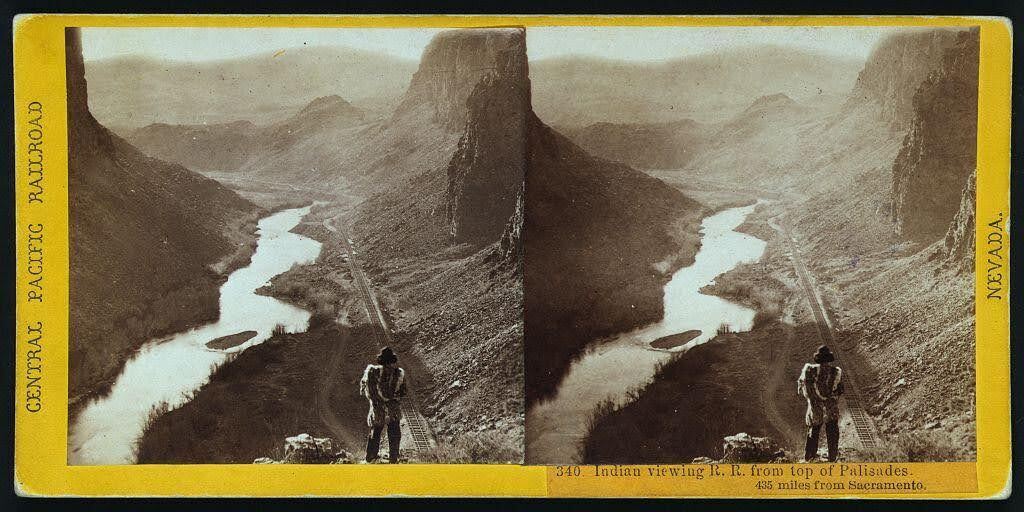
    <summary type="html"><![CDATA[<p><strong><em>Alfred A. Hart’s photo neatly captures the relationship that the United States had with Indigenous nations in the 19th century: persistent encroachment on and abuse of Native land. </em></strong></p><img src="https://www.intermountainhistories.org/files/fullsize/68061ca83529f9dba3c1da8a26419a79.jpg" alt="“Indian viewing railroad from top of Palisades. 435 miles from Sacramento.” " /><br/><p>Winding through the arid region of modern-day north central Nevada, the Humboldt River provided resources to support communities of a few hundred people. Punodungahnivain, or “Place where the house is” in Western Shoshone, was an area at the mouth of the South Fork River, between modern-day Carlin, Elko, and South Fork, that was home to Western Shoshone. </p><p>Water—and therefore the river—is sacred for the Western Shoshone, or “Newe” meaning “The People.” The Humboldt represents an important thoroughfare in ancient and modern trade routes, connecting goods from the Pacific with those in the Great Basin and western Rocky Mountains. The fertile river enabled Indigenous communities to thrive between modern-day Carlin and Elko. Roots and berries grew along the river, attracting birds and animals, and pine nut resources grew in the nearby Ruby mountains. The Shoshones hunted waterfowl, antelope, trout, gopher, rabbit, and beaver. </p><p>Trappers such as Peter Skene Ogden from the Hudson’s Bay Company arrived in the Humboldt region in the 1820s. They trapped as many beavers as possible in order to make it unprofitable for their competition, nearly wiping out the beaver population for a generation. After the discovery of gold at Sutter’s Mill in 1848, miners and settlers traveled along the Humboldt by the tens of thousands, negatively impacting the environment, depleting finite resources, and disrupting Indigenous lifeways. The California Trail transected Western Shoshone Territory throughout the 1840s through 1860s. Then, in the 1860s, the Central Pacific Railroad began building their Railroad from Sacramento, California, westward towards Utah Territory to join with the Union Pacific at Promontory Summit on May 10, 1869. </p><p>By the time CPRR worker Alfred A. Hart took the photo below, dated between 1865 and 1869, natural resources had already been depleted all along the Humboldt. Hart took hundreds of photographs as he traveled with the company, and many of them feature Shoshones. The completion of the railroad brought even more people west, who settled near the tracks in order to benefit from future commerce. These newcomers claimed the most fertile places for themselves and divided up ancestral Shoshone and Paiute lands. </p><p><em><strong><a href="https://www.intermountainhistories.org/items/show/851">For more (including 3 images) view the original article</a></strong></em></p>]]></summary>
    <published>2024-09-25T01:12:50+00:00</published>
    <updated>2026-04-17T19:32:19+00:00</updated>
    <link rel="alternate" type="text/html" href="https://www.intermountainhistories.org/items/show/851"/>
    <id>https://www.intermountainhistories.org/items/show/851</id>
    <author>
      <name>Ella Henricksen, Brigham Young University</name>
    </author>
  </entry>
  <entry>
    <title type="html"><![CDATA[Bryce Canyon Lodge and Deluxe Cabins - Bryce Canyon National Park]]></title>
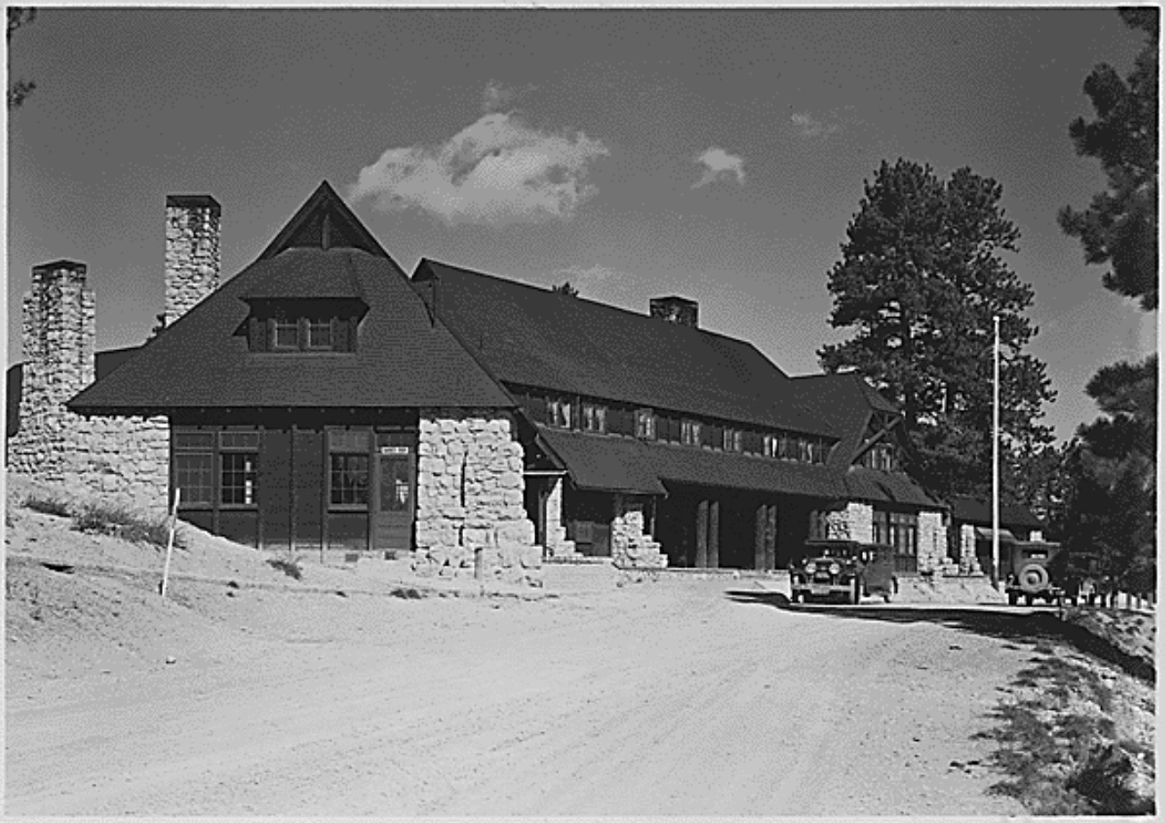
    <summary type="html"><![CDATA[<p><strong><em><span style="font-weight:400;">In 1923, the Union Pacific Railroad created the Utah Parks Company, which connected its rail line to attractions such as Zion National Park and the North Rim of Grand Canyon National Park. The Bryce Canyon Lodge and Deluxe Cabins linked Bryce Canyon State Park to this system of resorts in 1925. </span></em></strong></p><img src="https://www.intermountainhistories.org/files/fullsize/2d65ab73bf5bf337b81a40dba1d6d45e.jpg" alt="Bryce Canyon Lodge, c. 1929" /><br/><p><span style="font-weight:400;">In 1874, Bryce Canyon became part of a cattle ranch owned by Ebenezer Bryce. His ranch was unsuccessful, but automobile tourism revitalized the area when passable roads reached what is now Zion National Park in 1917. In 1921, Utah’s state legislature accepted a proposition from Park Service director Stephen Mather that protected Bryce Canyon as a state park. Utah made no attempt to develop the area for public use, but the Union Pacific Railroad spurred development in Bryce Canyon by creating the Utah Parks Company in 1923. This connected the Union Pacific’s Cedar City spur line to Bryce Canyon, the North Rim of Grand Canyon National Park, and Zion via bus lines. By establishing a network of parks and resorts, the Union Pacific aimed to compete with other successful railroad companies such as the Northern Pacific, Atchison-Topeka Santa Fe, and Great Northern. These companies had established successful tourist attractions at the South Rim of Grand Canyon, Yellowstone National Park, and Glacier National Park. As tourism brought in profit, road construction improved access to rural points of interest like Bryce Canyon. In 1924, Congress established Utah National Park, and the Utah Parks Company constructed Bryce Canyon Lodge and Deluxe Cabins in the same year to provide visitors with accommodations. Congress enlarged Utah National Park and renamed it Bryce Canyon in 1928. </span>
<span style="font-weight:400;">The Utah Parks Company enlisted Gilbert Stanley Underwood, one of the Union Pacific’s consulting architects, to design Bryce Canyon Lodge. Underwood’s designs are notable for their commitment to rustic architecture, which used natural materials and textures to blend a building with its natural surroundings. He utilized locally quarried stone and large, exposed wooden details throughout the structure, figuratively connecting the building to its location. After the company completed the original building in 1925, it added two new wings in 1926 to make room for an increasing number of visitors. The Utah Parks Company constructed fifteen deluxe guest cabins the following year in a pine grove near the main structure. Their design used rough stone and natural wood to imitate the design of Bryce Canyon Lodge. </span>
<span style="font-weight:400;">During the 1950s, the National Park Service renovated Bryce Canyon Lodge to make room for updated amenities. The hotel originally housed a barber shop, but the Park Service replaced it with a soda fountain. The Park Service also enlarged a road at the hotel’s front entrance to make room for larger vehicles, but the Park service expanded a plaza outside Bryce Canyon Lodge’s front entrance by removing the original bus lane in 1989. In 1985, the Park Service removed sixty-one of the lodge’s original sixty-seven standard cabins. The Sunrise Motel and Sunset Motel replaced them. In 1995, the National Register of Historic Places officially listed forty-two buildings in Bryce Canyon, including Bryce Canyon Lodge. This restricted future renovations, allowing the complex to retain most of its architectural significance. Today, Bryce Canyon Lodge operates as a historic hotel alongside five standard cabins and fifteen deluxe cabins. </span></p><p><em><strong><a href="https://www.intermountainhistories.org/items/show/843">For more (including 5 images) view the original article</a></strong></em></p>]]></summary>
    <published>2024-05-29T21:42:39+00:00</published>
    <updated>2026-04-17T19:32:19+00:00</updated>
    <link rel="alternate" type="text/html" href="https://www.intermountainhistories.org/items/show/843"/>
    <id>https://www.intermountainhistories.org/items/show/843</id>
    <author>
      <name>Kaylen Wilson, Northern Arizona University </name>
    </author>
  </entry>
  <entry>
    <title type="html"><![CDATA[Many Glacier Hotel: Glacier National Park ]]></title>
    <summary type="html"><![CDATA[<p><strong><em>After Congress created Glacier National Park in 1910, the Great Northern Railway constructed a complex network of hotels, chalets, roads, trails, and tent camps in the region. The railroad modeled this system after luxury resorts in Europe, and Many Glacier Hotel served as one of its crown jewels.</em></strong></p><img src="https://www.intermountainhistories.org/files/fullsize/2eecb9d891c46a783d81ec6dcc049230.jpg" alt="Many Glacier Hotel, c. 1921" /><br/><p><span style="font-weight:400;">Constructed at the edge of what is now Swiftcurrent Lake, Many Glacier Hotel provided the Great Northern Railway’s second grand hotel at Glacier National Park. It served as the center of the Great Northern’s network of chalets and tent camps alongside the 1910 Glacier Park Hotel. From the grand hotels, tourists could access chalets and tent camps in Glacier’s backcountry. Visitors accessed these locations on horseback, but automobiles later drew tourists away from them. The Great Northern brought an unprecedented level of development into Glacier, and it spent approximately $1.5 million on hotels, chalets, campsites, trails, and roads by 1917. Many Glacier Hotel cost $400,000. </span>
<span style="font-weight:400;">Designed by Great Northern architect Thomas D. McMahon, the hotel comprises three separate buildings connected by covered walkways. The central portion opened in 1915, but the railroad did not complete the hotels’ north and south ends until 1917. Its rough stone siding and foundations resemble the rustic architecture that was becoming increasingly common in national parks. The architect further emphasized this feature in the lobby, which included a grand fireplace and tall wooden support pillars. This imitated the “forest” lobby at Glacier Park Hotel, which uses massive Douglas fir trees as pillars and includes an open fire pit. Many Glacier briefly featured an indoor pool, but the Great Northern removed it due to sanitary issues. </span>
<span style="font-weight:400;">The railroad also intended Many Glacier to match the Great Northern’s other buildings in the park, which imitate Swiss chalets. The hotel’s three sections look like individual Swiss chalets from a distance. Wooden pieces called moldings adorn their windows and balconies, and these pieces feature cutout patterns inspired by the Swiss chalet style. This created a unified sense of place in the region and emulated Glacier’s status as the “Switzerland of North America.” Early advertisements capitalized on this idea during World War I, encouraging guests to “see America first” instead of spending their vacation money to visit foreign locales. The Great Northern hired numerous artists to paint Glacier National Park, and their work hung in train depots and ticket offices. The railroad displayed a variety of paintings from the See America First in Many Glacier Hotel, but only a few remain today. </span>
<span style="font-weight:400;">While Glacier National Park quickly became a popular tourist attraction, the Great Northern’s vast building network became increasingly expensive to maintain. Initially, the railroad kept its resort system to draw train passengers into the park, but it made numerous attempts to sell the hotels as more visitors began to arrive by car. In 1957, the Great Northern hired the Knutson Hotel Company to prepare Glacier’s hotels for sale, and Glacier Park Inc. purchased them in 1960. In 2001, the National Park Service funded a $42 million restoration project that replaced the lodge’s roof and siding, restored original architectural features like balconies, and reinstalled an original circular staircase that the Knutson Hotel Company removed from the hotel lobby in 1957. Xanterra Parks and Resorts currently manages Many Glacier Hotel.</span></p><p><em><strong><a href="https://www.intermountainhistories.org/items/show/842">For more (including 5 images) view the original article</a></strong></em></p>]]></summary>
    <published>2024-05-29T21:10:56+00:00</published>
    <updated>2026-04-17T19:32:19+00:00</updated>
    <link rel="alternate" type="text/html" href="https://www.intermountainhistories.org/items/show/842"/>
    <id>https://www.intermountainhistories.org/items/show/842</id>
    <author>
      <name>Kaylen Wilson, Northern Arizona University</name>
    </author>
  </entry>
  <entry>
    <title type="html"><![CDATA[Glacier Park Hotel - Glacier National Park]]></title>
    <summary type="html"><![CDATA[<p><strong><em>In 1911, the Great Northern Railway began constructing a complex network of hotels and chalets in the fledgling Glacier National Park. Originally nicknamed the “Entrance hotel,” Glacier Park Hotel provided a gateway to this unique resort system.</em></strong></p><img src="https://www.intermountainhistories.org/files/fullsize/06a86c061b2ec07ad3f9f6d5b187daae.jpg" alt="Glacier Park Hotel lobby, c. 1910-20" /><br/><p><span style="font-weight:400;">The Great Northern Railway constructed Glacier Park Hotel in 1913 to provide visitors touring Glacier National Park with a starting point along the railroad. From Glacier Park Hotel, these tourists entered a complex system of smaller chalets and tent camps. Each hotel and chalet included a guide operation that provided saddle horses to visitors, who entered the area from a train depot connected to the Glacier Park complex. Resorts in Europe inspired this system, and an American national park had never utilized it. The resort brought an unprecedented level of development into Glacier, and the Great Northern spent about $1.5 million dollars (about $36 million today) on hotels, chalets, campsites, trails, and roads by 1917. </span>
<span style="font-weight:400;">The Great Northern Railroad executive F.I. Whitney encouraged the railroad to seek out tourist attractions in the Glacier region as soon as it reached the park’s southern end. Famous conservationists like George Bird Grinnell and John Muir, who brought Glacier to the attention of railroad founder James J. Hill and his son Louis, reinvigorated Whitney’s efforts. The failure of local oil and copper and oil industries provided a political opening for conservationists, and James J. Hill soon began to advocate for the area’s protection. However, Hill opposed the conservationists’ idea of a vast forest reserve at Glacier, and this ultimately shaped the park’s development. President William Howard Taft signed the bill that protected Glacier National Park in 1910. </span>
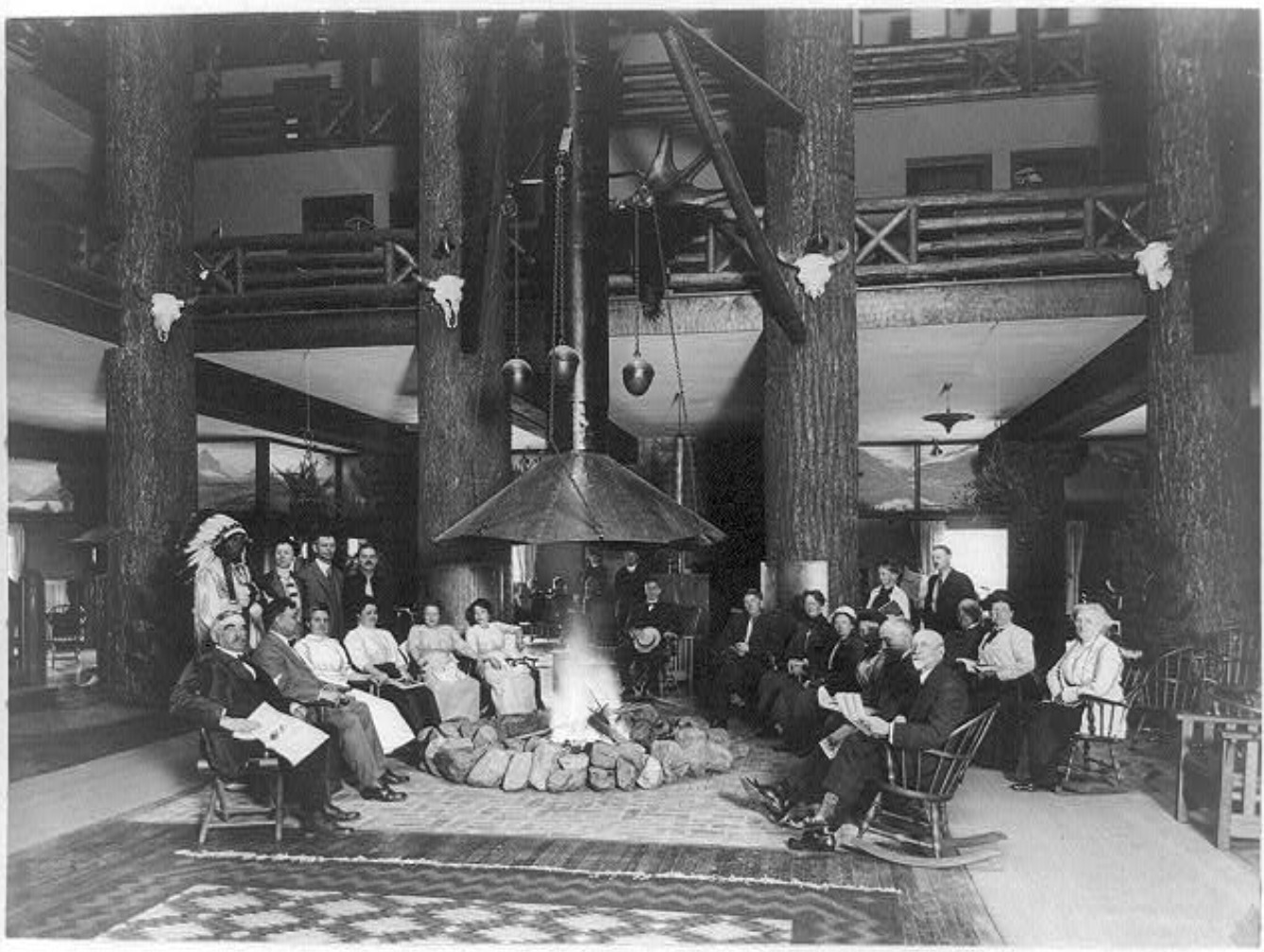
<span style="font-weight:400;">Luxurious chalets in Switzerland inspired the architecture of Glacier Park Hotel and the Great Northern’s other buildings, which catered to the tastes of wealthy travelers. Louis Hill, who served as president of the Great Northern during construction, chose this style. It connected the system visually and advertised Glacier’s reputation as the “Switzerland of North America.” Glacier Park Hotel, designed by Samuel Bartlett, is particularly famous for its massive log pillars, which support the hotel’s vast roof. These logs vary in size, with the largest being over forty feet tall and three to four feet wide, and they are most prevalent in the hotel’s lobby. Advertised as a “forest,” these log posts retain their bark, emphasizing their organic nature and contributing to the idea of an indoor forest. The lobby even includes a fire pit in its center. These features emphasized the hotel’s environment and emulated the rough, handcrafted style popularly defined as rustic architecture. The luxurious complex included a</span> <span style="font-weight:400;">music room, writing room, a sun parlor, and a hospital in case of emergencies. </span>
<span style="font-weight:400;">In 1957, the Great Northern hired Knutson Hotel Company to renovate its hotels for sale. The $3 million project expanded the hotel gift shop, installed bathrooms in all the guest rooms, added a swimming pool to the hotel complex, and renamed the hotel Glacier Park Lodge. In 1960, Glacier Park Inc. purchased the Glacier resort system from the Great Northern. The National Park Service granted Xanterra Parks and Resorts concession rights in Glacier in 2013, but Glacier Park Inc. retained Glacier Park Lodge and several other properties.</span></p><p><em><strong><a href="https://www.intermountainhistories.org/items/show/841">For more (including 4 images) view the original article</a></strong></em></p>]]></summary>
    <published>2024-05-29T20:53:22+00:00</published>
    <updated>2026-04-17T19:32:19+00:00</updated>
    <link rel="alternate" type="text/html" href="https://www.intermountainhistories.org/items/show/841"/>
    <id>https://www.intermountainhistories.org/items/show/841</id>
    <author>
      <name>Kaylen Wilson, Northern Arizona University</name>
    </author>
  </entry>
  <entry>
    <title type="html"><![CDATA[El Tovar Hotel - Grand Canyon National Park ]]></title>
    <summary type="html"><![CDATA[<p><strong><em>In 1901, the Atchison-Topeka Santa Fe Railway constructed a spur line from Williams, Arizona, that provided access to the Grand Canyon’s South Rim. El Tovar soon followed, providing its guests with the region’s first luxury accommodations.</em></strong></p><img src="https://www.intermountainhistories.org/files/fullsize/4856f91fdf081f933e9854aa688f9055.jpg" alt="El Tovar’s east side, circa 1905" /><br/><p><span style="font-weight:400;">Before the Atchison-Topeka Santa Fe Railway reached Grand Canyon Village in 1901, only a few rudimentary hotels served the Grand Canyon’s South Rim. These establishments relied on a local stagecoach line, which operated between Flagstaff, Arizona and a ranch near the rim. Because the twenty-dollar journey took three days to complete, the railroad provided a more efficient way to reach the canyon, and its arrival shifted the center of activity at Grand Canyon Village away from Thurston’s stagecoach line. Fred Harvey, a hospitality company whose Harvey houses provided quality food and lodging to passengers on the Santa Fe Railway, constructed El Tovar near the railroad tracks to draw in train passengers. The hotel cost $250,000 to construct, providing the Grand Canyon’s first luxury lodgings. </span>
<span style="font-weight:400;">Opened in 1905, El Tovar hotel predated the Grand Canyon’s designation as a national monument in 1908 and a national park in 1919. As a national monument, the Grand Canyon received less funding and attention than established national parks like Yellowstone. However, as tourism increased, calls for the area to receive further protections intensified. Ford Harvey, who served as president of the Harvey company until 1928, routinely advocated for Grand Canyon’s national park status at conferences. Conservation efforts gained strength when Arizona became a state in 1912, but many Grand Canyon residents opposed the national park proposal due to concerns about land and mineral rights. Regardless, President Woodrow Wilson officially signed the bill that established Grand Canyon National Park on February 26, 1919, and the Harvey company secured a hospitality contract from the new National Park Service (created in 1916) in 1920.</span>
<span style="font-weight:400;">Architect Charles Whittlesey’s design for El Tovar used the rustic architectural style, which aimed to establish a connection between buildings and their environment. Whittlesey designed the log siding on the first floor to resemble the wall of a log cabin. Natural building materials like rough stone and logs appear throughout the building, reinforcing this style. Whittlesey combined these rustic features with the architecture of traditional luxury resorts, which catered to Victorian tastes and a desire for exotic destinations. Decorative wooden poles known as balusters, which mimic Swiss chalet architecture, enclose El Tovar’s porches and balconies. The design also includes a small round tower known as a turret, which echoes resort architecture. </span>
<span style="font-weight:400;">El Tovar originally featured luxurious amenities, including hot running water and electric lighting. In the 1950s, the Harvey company added a new cocktail lounge to the hotel’s dining area. A 1983 renovation exchanged the hotel’s sparse public restrooms with private facilities, added carpeting, replaced windows, and included a new heating system. For this reason, El Tovar currently houses seventy-nine rooms instead of the original ninety-five. In 1968, Hawaii-based hospitality company Amfac purchased the Harvey company and gained control of El Tovar. In the 1990s, Amfac created Xanterra Parks and Resorts to control its concessions at the Grand Canyon, and Xanterra still manages El Tovar today. </span></p><p><em><strong><a href="https://www.intermountainhistories.org/items/show/840">For more (including 6 images) view the original article</a></strong></em></p>]]></summary>
    <published>2024-05-29T20:25:01+00:00</published>
    <updated>2026-04-17T19:32:19+00:00</updated>
    <link rel="alternate" type="text/html" href="https://www.intermountainhistories.org/items/show/840"/>
    <id>https://www.intermountainhistories.org/items/show/840</id>
    <author>
      <name>Kaylen Wilson, Northern Arizona University </name>
    </author>
  </entry>
  <entry>
    <title type="html"><![CDATA[Old Faithful Inn - Yellowstone National Park]]></title>
    <summary type="html"><![CDATA[<p><strong><em><span style="font-weight:400;">When the Northern Pacific Railroad’s Upper Geyser Basin Hotel burned to the ground on November 17, 1894, the U.S government pressured the railroad to replace it with new tourist accommodations. The result was Old Faithful Inn, which utilized a new style of architecture to highlight Yellowstone’s iconic landscape. </span></em></strong></p><img src="https://www.intermountainhistories.org/files/fullsize/eddddd6f4d185123b8615299ae39a69b.jpg" alt="Old Faithful Inn, Entrance Drive" /><br/><p><span style="font-weight:400;">On March 1, 1872, President Ulysses S. Grant officially signed Yellowstone into law as America’s first national park. The Yosemite Act of 1864 had restricted settlement in the Yosemite Valley and placed it under the jurisdiction of California’s state government, but the Yellowstone Park Act expanded upon this legislation by designating all of Yellowstone a public park. As a result, the Yellowstone Park Act contained many restrictions on private development and very few administrative procedures to enforce regulations or oversee public use. Poorly supervised independent companies called concessionaires, who paid park administrators a fee to use the land, ran Yellowstone’s public facilities. Only a few concessionaires ferried guests into the park, but the Northern Pacific Railroad quickly expressed interest in Yellowstone’s small tourism industry.</span>
<span style="font-weight:400;">When the Northern Pacific reached Gardiner, Montana, in the early 1880s, its presence provoked interest in Yellowstone’s tourism industry. At this time, only a few concessionaires opened small hotels and tent camps. One such concessionaire, the Yellowstone Park Improvement Company, constructed the Upper Geyser Basin Hotel in 1885 to preserve its failing business. The Northern Pacific purchased its properties in 1885, gaining control of the Upper Geyser Basin Hotel. When fire destroyed it</span><span style="font-weight:400;"> in 1894,</span><span style="font-weight:400;"> the importance of a new hotel in Yellowstone became clear</span><span style="font-weight:400;">. At the time</span><span style="font-weight:400;">, many railroad hotels utilized conventional architectural styles that provided a sense of familiarity for their upper-class audience. The Northern Pacific’s Lake Hotel, constructed in 1890, followed this example. However, </span><span style="font-weight:400;">rustic architecture, which emphasized harmony with the natural environment surrounding a structure, gained popularity in the 1890s. Because distinctive architecture drew more attention from visitors, the Northern Pacific experimented with a rustic style for its new hotel. </span>
<span style="font-weight:400;">The Yellowstone Park Association, a subsidiary of the Northern Pacific, selected Robert Reamer to design its new rustic hotel. The railroad constructed the log building near Yellowstone’s most famous geyser, from which the Old Faithful Inn derived its name. </span><span style="font-weight:400;">The Union Pacific completed the central core of the hotel, known as the “Old House,” in 1903.</span><span style="font-weight:400;"> The finished building was seven stories tall at its highest point, and it cost a total of $140,000 (about $4.9 million today) to construct. The Northern Pacific set aside a further $25,000 (approximately $875,000 today) to furnish the new hotel. Reamer designed his massive log structure to emulate Swiss chalets and Norwegian villas, and he utilized rough, unfinished wood logs obtained in the Park on both the inside and outside of the building to connect it to Yellowstone’s forested landscape. The hotel’s most prominent feature is its seven-story lobby, which features a vast fireplace made of native stone. A complex log frame that supports the hotel’s roof surrounds this room. The structure’s use of exposed wooden supports emphasizes the rustic nature of the lobby, and a series of wooden balconies overlook the main floor of the hotel. </span></p><p><em><strong><a href="https://www.intermountainhistories.org/items/show/839">For more (including 5 images) view the original article</a></strong></em></p>]]></summary>
    <published>2024-05-29T19:43:03+00:00</published>
    <updated>2026-04-17T19:32:19+00:00</updated>
    <link rel="alternate" type="text/html" href="https://www.intermountainhistories.org/items/show/839"/>
    <id>https://www.intermountainhistories.org/items/show/839</id>
    <author>
      <name>Kaylen Wilson, Northern Arizona University</name>
    </author>
  </entry>
  <entry>
    <title type="html"><![CDATA[Saltair Beach at Great Salt Lake: The &quot;Coney Island of the West&quot; ]]></title>
    <summary type="html"><![CDATA[<p><strong><em>Attracting visitors to float in its salty waters, the southern beaches at Great Salt Lake became increasingly popular with the Saltair Resort but now face environmental threats.</em></strong></p><img src="https://www.intermountainhistories.org/files/fullsize/1dca8d46b480914c5e65caf4b1a71f24.jpg" alt="[Untitled]" /><br/><p>The Great Salt Lakes' southern beach became a well-known vacation spot because of the Saltair Resort and its motto “Try to Sink” which encouraged visitors' curiosity to swim and float in the salty waters. Today, the beach has seen a drop in visitation due to receding water levels, with about 130,000 fewer visitors from 2012 to 2022. At the beach's peak visitation during the late nineteenth century and early twentieth century, beach life consisted of swimming, picnicking, and carnival rides such as a rollercoaster, merry-go-round, and Ferris wheel.</p><p>The Goshute tribe and the Skull Valley Goshutes live near and still use the resources of the southern end of Great Salt Lake. In 1847, Mormon settlers first came to Salt Lake Valley and initiated the recreational beach life on the lake. In the 1860s, Mormon settler Heber Kimball built a ranch near Black Rock Beach. Known later as “Rock House” this spot became the first well-known swimming spot on the lake. Attraction grew with the completion of the Utah Central Railroad in 1870 and the Utah-Nevada Railway in 1875 which made Black Rock and the future Saltair Beach accessible to transcontinental visitors.</p><p>In 1893, Deseret News announced the construction of a new resort called “Saltair.” The Church of Jesus Christ of Latter-day Saints invested the most money in the Saltair Beach Company and hoped to create a wholesome recreational resort that was family-oriented. Saltair opened in 1893 and soon was nicknamed “Coney Island of the West” for its many carnival and recreational attractions. The beaches were most popular on American holidays such as the Fourth of July with thousands of people visiting to swim on weekends and special occasions. In 1919 attendance reached 450,000 people and the resort's popularity peaked during the 1920s. However, on April 22, 1925, Saltair burned down for unknown reasons, and by the 25th, its manager announced rebuilding efforts with no proposed start date. With the promise to be “larger, stronger, and more beautiful” than ever by the Salt Lake Tribune, the second Saltair opened in May of 1926. Nonetheless, the resort did not live up to its predecessor and presently the third Saltair, due to another fire, serves as a concert venue.</p><p>Saltair was the center of beach life at the southern shore of Great Salt Lake, and with the decline of the resort came the decline of beach life. The latest reviews describe the beach as having great views, but decreasing water levels means a long and smelly walk to the water. In 2023 alone the lake lost two feet of water to evaporation and while Utah policymakers and environmental programs have forged a plan to save the lake, they did not include any Native tribes in the conversation. Today, people can still swim, or rather float, in the 12% average salinity levels of the Great Salt Lake compared to the Pacific Ocean's 3.5% average salinity. As well as kayak, boat, and sunbathe on the southern beach's shores and marina.</p><p><em><strong><a href="https://www.intermountainhistories.org/items/show/827">For more (including 5 images) view the original article</a></strong></em></p>]]></summary>
    <published>2024-05-23T00:29:57+00:00</published>
    <updated>2026-04-17T19:32:18+00:00</updated>
    <link rel="alternate" type="text/html" href="https://www.intermountainhistories.org/items/show/827"/>
    <id>https://www.intermountainhistories.org/items/show/827</id>
    <author>
      <name>Olivia Hall, Northern Arizona University</name>
    </author>
  </entry>
  <entry>
    <title type="html"><![CDATA[Mining in Madrid, NM]]></title>
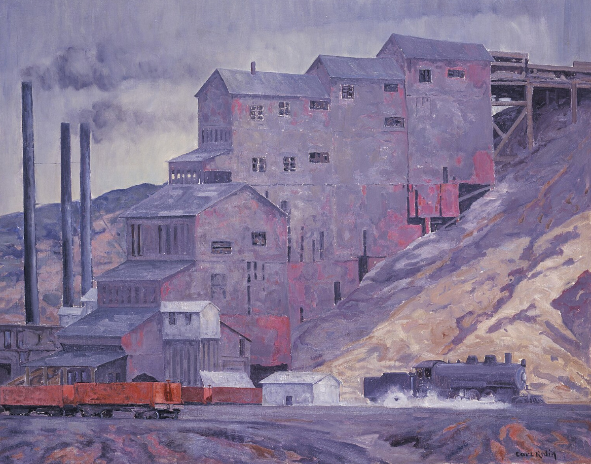
    <summary type="html"><![CDATA[<p><strong><em><span style="font-weight:400;">Once a coal mining town with mandated celebratory traditions, Madrid is kept alive today by a community of artists.</span></em></strong></p><img src="https://www.intermountainhistories.org/files/fullsize/2c557ddeacfb0b63a0565ae116711530.jpg" alt="At Madrid Coal Mine, New Mexico" /><br/><p><span style="font-weight:400;">There is a community in the mountains of Santa Fe County, New Mexico that has redeemed itself from “ghost town” status–though they still claim the title. Madrid was best known for its wealth of coal during the mining boom in the late nineteenth and early twentieth century. The town was first founded in 1869, attracting attention from its location along the Santa Fe Railroad. Traveling journalist Charles Fletcher Lummis said that there was no other railroad that “penetrated such a wonderland of the pictorial in geography and in humanity.” Trains used Madrid to refuel and stock up on coal. The prosperity of the land brought in a large enough community for businesses like the trading post, stores, schools, a diner, and a boarding house to be built and well-used in the early twentieth century. </span>
<span style="font-weight:400;">Life in mining towns is sometimes thought of as exciting–newfound wealth and communities brought together in the wake of the gilded age–but the reality was far grittier. Men, women, and children who worked in coal mines were subject to the dangers of collapsing shafts, explosions, and machinery malfunctions, as well as gas poisoning and other illnesses brought on by poor air quality. However, the corporations running the town had several initiatives that attempted to make life more enjoyable for the residents. </span>
<span style="font-weight:400;">The free electricity they provided to each home was certainly the most valuable perk, but there were also annual festivities that were required in an attempt to boost the community’s morale. As Christmas approached each year, every resident had to ornament their house with string lights, buy a Christmas tree, and make sure their house was as much of a spectacle as possible. With 3,000 residents by the 1930s, Madrid did become quite a spectacle, drawing in crowds from Albuquerque and other nearby communities in awe of the light displays. When blackouts for World War II started, the Christmas lights were put out, and shortly after the war ended, the mines were closed for good.</span>
<span style="font-weight:400;">As steam locomotives were replaced with diesel engines, coal lost its value and the mines in Madrid were shut down not long after the war ended. The population rapidly declined, and Madrid sat among other former mining towns in Santa Fe county, with the threat of complete abandonment. Yet, Madrid never quite lost its charm. It went on to be featured in several movies, from 1970 to the early 2000s, and now it is home to artists, quirky landmarks, and converted historic buildings. </span></p><p><em><strong><a href="https://www.intermountainhistories.org/items/show/805">For more (including 3 images) view the original article</a></strong></em></p>]]></summary>
    <published>2024-05-16T01:44:03+00:00</published>
    <updated>2026-04-17T19:32:18+00:00</updated>
    <link rel="alternate" type="text/html" href="https://www.intermountainhistories.org/items/show/805"/>
    <id>https://www.intermountainhistories.org/items/show/805</id>
    <author>
      <name>Megan Bailey, Brigham Young University</name>
    </author>
  </entry>
  <entry>
    <title type="html"><![CDATA[Apache County on Route 66]]></title>
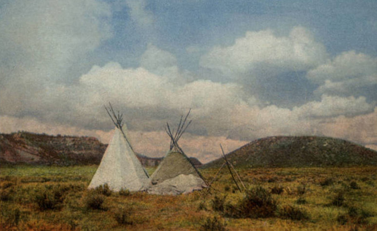
    <summary type="html"><![CDATA[<p><strong><em><span style="font-weight:400;">The land on the Arizona-New Mexico border has a storied past–from Spanish trading routes and gutsy American cowboys to railroad tracks and the boom of a brand-new highway.</span></em></strong></p><img src="https://www.intermountainhistories.org/files/fullsize/c94d71a364203dd0571092e6433d1afa.jpg" alt="In Apache Land, Arizona" /><br/><p><span style="font-weight:400;">Apache County, which makes up the northeast region of Arizona, has been occupied since at least 800 A.D. by Ancestral Puebloans (formerly known as “Anasazi”). The first of many Spanish expeditions to the Arizona/New Mexico region lasted from 1540-1542, and began a tumultuous relationship with the indigenous population. In the following years Spanish colonists introduced new cattle to the region, and sheepherding became a popular practice for the next several hundred years. In 1864 the U.S. government issued a forced displacement of the Navajo people known as the “Long Walk.” It was a harsh and unforgiving journey that resulted in at least 500 deaths. One region exiled during the Long Walk later became known as Lupton, one of several unincorporated communities along Route 66. </span>
<span style="font-weight:400;">Famous for its scenic “painted cliffs,” brightly colored roadside shops, and appearance in the 1940 film adaptation of </span><i><span style="font-weight:400;">Grapes of Wrath</span></i><span style="font-weight:400;">, Lupton was built from a railroad settlement in 1905. The community's namesake, G.W. Lupton, was a trainmaster and owner of the first trading post in the area. In the post-war tourism boom of the early 1950s, the Yellowhorse family of the Navajo Reservation opened their own trading post. The building was painted a striking yellow with red and black painted signage advertising “The Indian Market Place: Deal with the Friendly Navajo.” Although Route 66 had given the area a new life after the railroad revolution, the construction plans for Interstate 40 bypassed Lupton. Like so many other little towns that survived only from the tourist revenue, Lupton soon slipped into obscurity. The shop fronts have not been well-preserved, and there is not much charm left to draw people in, but the sight of the painted cliffs when the sun hits them just right remains as breathtaking as it always was.</span>
<span style="font-weight:400;">Twelve miles west of Lupton and the New Mexico border another now deserted town called Houck has its own storied past. In 1877 James Houck, a horseback-riding mail carrier, established a trading post along his route which ran from Prescott, Arizona to Fort Wingate, New Mexico. The post, which was called “Houck’s Tank,” expanded into a small community which adopted Houck’s name. He lived a fairly successful life, but had a hard time staying out of trouble. He was no stranger to shoot-outs or plots of revenge–and his friendship with the Tewksbury family put him in the middle of a major feud between two ranching families. Known as the Pleasant Valley War or the Graham-Tewksbury Feud, it resulted in somewhere between thirty-five to fifty deaths. His career beyond mail delivery included sheepherding, mining, trading, and a position as the Apache County Deputy Sheriff. Yet he is memorialized now as the namesake for the once lively ghost town of Houck, Arizona.</span>
<span style="font-weight:400;">In late 1926, Route 66 made its way through Houck, attracting new visitors to what had once been nothing more than a trading post. Although becoming a part of Route 66 helped bring a more steady flow of business and traffic, Houck never quite blossomed the way other towns along the highway did. A gas station, a grocery store, a “Pancake House,” and a few other small establishments popped up, but much of it has since gone out of business and become overgrown. In 1998, long after the excitement died down, the Native American Bahá'í Institute opened as a place of worship, training, and gathering place for the Navajo reservation and surrounding communities. </span></p><p><em><strong><a href="https://www.intermountainhistories.org/items/show/800">For more (including 5 images) view the original article</a></strong></em></p>]]></summary>
    <published>2024-05-15T20:15:34+00:00</published>
    <updated>2026-04-17T19:32:17+00:00</updated>
    <link rel="alternate" type="text/html" href="https://www.intermountainhistories.org/items/show/800"/>
    <id>https://www.intermountainhistories.org/items/show/800</id>
    <author>
      <name>Megan Bailey, Brigham Young University</name>
    </author>
  </entry>
  <entry>
    <title type="html"><![CDATA[Anti-Chinese Riot near Virginia City, Nevada]]></title>
    <summary type="html"><![CDATA[<p><strong><em>In 1869, with anti-Chinese sentiment growing in the west, a mob in Virginia City, Nevada attempted to expel the Chinese immigrants from town. They raided the railroad where the Chinese were laying tracks, demanded their departure, and destroyed all of their property. </em></strong></p><img src="https://www.intermountainhistories.org/files/fullsize/b8f3b7605935f2ffe65447f76de43fe6.jpg" alt="Three Chinese Women and a Chinese Boy in Virginia City" /><br/><p><span style="font-weight:400;">In the latter half of the nineteenth century, thousands of people, including many immigrants, flocked to the Intermountain West region in search of economic opportunity. Virginia City, Nevada was a popular destination for these laborers due to its booming silver mining industry. The city sprung up in the late 1850s, and by the late 1860s, it was the largest mining town in Nevada. Most who migrated to Virginia City were of European descent, but the town also attracted many Chinese laborers. As was common in other parts of the country, the Chinese in Virginia City were willing to work for lower wages than other ethnic groups. This increased the competitiveness of the labor market in Virginia City and turned other groups against the Chinese community. </span>
<span style="font-weight:400;">In 1869, anti-Chinese sentiment was running high in Virginia City, and the unionized miners in the city decided to act against the Chinese laborers working on grading the Virginia and Truckee Railroad. On September 29th, a mob of nearly 400 men marched on the Chinese. Sensing trouble, Sheriff W. J. Cummings followed the mob and tried to stop them, but he was powerless against the mass of angered miners. When the mob arrived at the tracks, they demanded that the Chinese depart within thirty minutes and began destroying their property and makeshift residences. Luckily, no Chinese people were injured by the mob, but the property destruction was extensive. </span>
<span style="font-weight:400;">A week later, William Sharon, a railroad official, met with the leaders of the mob and came to an agreement with two provisions: first, the railroad would stop employing Chinese workers; and second, the mob would stop harassing the Chinese. Sharon was reluctant to enter into this agreement because he could employ Chinese laborers at a better rate than white laborers, but the mob could not be reasoned with. They simply wanted the Chinese gone. </span>
<span style="font-weight:400;">Local newspapers condemned the actions of the mob and called for those involved to be arrested; however, they knew it would be extremely difficult to find a jury who would convict the mob members. Indeed, no action was taken against any of the mob participants. By October 21st, the railroad only employed workers of European descent. Many of the Chinese people did leave town, but others found various forms of employment in the city. Chinese people faced continual discrimination in Virginia City, but they continued to find work and ways to send money back to their families in China and make a life in the country.</span></p><p><em><strong><a href="https://www.intermountainhistories.org/items/show/729">For more (including 6 images) view the original article</a></strong></em></p>]]></summary>
    <published>2023-03-06T22:17:52+00:00</published>
    <updated>2026-04-17T19:32:16+00:00</updated>
    <link rel="alternate" type="text/html" href="https://www.intermountainhistories.org/items/show/729"/>
    <id>https://www.intermountainhistories.org/items/show/729</id>
    <author>
      <name>Sydney Wilson, Brigham Young University</name>
    </author>
  </entry>
  <entry>
    <title type="html"><![CDATA[The Hotel Metlen]]></title>
    <summary type="html"><![CDATA[<p><strong><em>Joseph Metlen, was a local businessman and politician who wanted to promote city growth in Dillon, Montana, by building a hotel in 1897. The Union Pacific Railroad brought travelers to the hotel.</em></strong></p><img src="https://www.intermountainhistories.org/files/fullsize/18eed40e8c1ccabadaace3e9bdede462.jpg" alt="Hotel Metlen" /><br/><p>Joseph C. Metlen was born in Pennsylvania in 1834. He arrived in Montana, in 1867, thirty years before he constructed Hotel Metlen. He and his brother worked as freighters from Corrine, Utah. Metlen valued his civic duty and represented Beaverhead County in the territorial legislature in 1871 and was elected as county treasurer in Dillion in 1883. As ambitious as he was, Metlen ran for sheriff in 1884 without success. The Hotel Metlen opened to the public on February 11, 1898.
The Metlen’s design modeled the Second Empire Style popular in the nineteenth century. Its most distinguishable feature is the Mansard roof typical of many other hotels built around the same period and most popular between the 1860s and 1880s. The roof’s style is recognizable by the slopes on each side. Another major characteristic of Second Empire architecture is the hotel’s two stories and brick walls. Inside of the building is a lobby, a bar, sample rooms, a kitchen, twenty-seven guest rooms, and the proprietor’s room. 
The hotel did not start successfully, as there were a few issues with its first structure. Originally, when the hotel was still named the Corrine in 1897, the structure was made of cloth-lined partitions that lacked the stability and permanence necessary for it to thrive. In 1892, a fire destroyed the Corrine, leading Metlen to build a new and improved hotel. With a clean slate, Metlen altered the structure’s overall appearance. These changes included painting the exterior white and building a penthouse on the roof. Metlen set up the hotel to potentially have multiple functions. (For example, during WWII, the penthouse served as an aircraft control center for report aircraft movements.) A local newspaper called the Hotel Metlen “the dawn of an era of better things for the city,” as it would attract tourists and provide commerce.
The hotel closed in 2008, but two bars inside the building, owned by Phylly Sax, remain open. Current staff have said that keys go missing and furniture moves, contributing to rumors of hauntings and strange activity. Most of the old furnishings and original woodwork remain intact. The appearance of the inside of the hotel caters to fans of the Old West aesthetic with a hodgepodge of items like pistols and animal skulls.</p><p><em><strong><a href="https://www.intermountainhistories.org/items/show/534">For more (including 5 images) view the original article</a></strong></em></p>]]></summary>
    <published>2021-11-13T08:44:10+00:00</published>
    <updated>2026-04-17T19:32:11+00:00</updated>
    <link rel="alternate" type="text/html" href="https://www.intermountainhistories.org/items/show/534"/>
    <id>https://www.intermountainhistories.org/items/show/534</id>
    <author>
      <name>Nova Jesswein, Northern Arizona University</name>
    </author>
  </entry>
  <entry>
    <title type="html"><![CDATA[The St. Charles Muller’s]]></title>
    <summary type="html"><![CDATA[<p><strong><em>In 1862 when George Remington and Albert Muller were in their twenties, they decided to build a brick hotel to help Carson City in Nevada Territory grow. Remington and Muller named the hotel after Saint Charles, modeling some finer hotels on the East coast with that name.</em></strong></p><img src="https://www.intermountainhistories.org/files/fullsize/2ab1c76dd24f8faad38a2f4360e93c1d.jpg" alt="The hotel restored" /><br/><p>The original owner of the St. Charles was French-born Albert J. Muller. Muller started his career in Carson City as a professional baker until he realized that a hotel business was more promising. Although most of his patrons were French-Canadian wood choppers, the hotel became a frequent host to social gatherings in town.
The hotel is the second oldest in Nevada, and it is one of the oldest extant commercial buildings in Carson City. It was typical for commercial buildings in the late-nineteenth century to have a low-pitched roof, decorative brackets under a cornice, and tall narrow windows. Initially, the hotel existed as two separate buildings. Construction on the northern section, the St. Charles, started April 1, 1862, and the southern section, the Muller Hotel, began the following month. Numerous alterations to the hotel over the years result in its unique look, not belonging to any particular architectural period. The architectural style is closest to Italianate, a style that was most common for many American main-street commercial buildings. 
The hotel remained a successful business as it went through several name and ownership changes until the 1980s. Before its period of decline, the hotel went through many transformations. In 1895, Gilbert and Dorcas Briggs changed its name to the Briggs’ House. In 1910, it became the Golden West Hotel. Over the years, the hotel changed again and was known as the Travelers Hotel, Hotel Page, the Pony Express Hotel when it was at its largest room count, and finally back to St. Charles Muller’s Hotel. Overall, the hotel’s ownership changed sixteen times over a 142-year period. On top of its many name changes, the hotel building has also several different businesses occupy its grounds. Some of these were a stagecoach office, a saloon, a restaurant, retail shops, and a grammar school classroom.
Not much of the building remains in its original form, yet it shows signs of the changes it has gone through in its purposes, names, and owners. Today, the hotel is beautifully painted red and gold. Rooms with modern décor and comforts are available through Airbnb, making it easy to book online. In the hotel’s history, there were periods of time where the hotel was inaccessible, but today it is open and catering to current methods of booking a place to stay.</p><p><em><strong><a href="https://www.intermountainhistories.org/items/show/533">For more (including 4 images) view the original article</a></strong></em></p>]]></summary>
    <published>2021-10-27T02:55:06+00:00</published>
    <updated>2026-04-17T19:32:11+00:00</updated>
    <link rel="alternate" type="text/html" href="https://www.intermountainhistories.org/items/show/533"/>
    <id>https://www.intermountainhistories.org/items/show/533</id>
    <author>
      <name>Nova Jesswein, Northern Arizona University</name>
    </author>
  </entry>
  <entry>
    <title type="html"><![CDATA[The Grand Imperial Hotel]]></title>
    <summary type="html"><![CDATA[<p><strong><em>The Thompson brothers constructed the Grand Imperial Hotel in 1882. The first train from Durango to Silverton, Colorado, arrived on July 4, 1882, the same year that construction of the hotel started.</em></strong></p><img src="https://www.intermountainhistories.org/files/fullsize/4e0e539a981e9dcd42a2fbe332095b39.jpg" alt="Grand Imperial" /><br/><p>The founder of The Grand Imperial, C.S. Thompson, represented the Crown Perfumery in London, England. He moved to Silverton, Colorado in 1882 to inspect mining prospects, and he purchased four lots of the twenty-first block to make Silverton “the best town in the Southern part of Colorado.” Thompson knew that a hostelry was necessary for housing visitors such as wealthy mine owners, black powder explosives salesmen and other speculators. Many of the early guests were, like Thompson, silver barons checking on their holdings.
The structure of the building includes French Second Empire features such as dormer windows that extend from the Mansard roof. The columns on the exterior of the first floor are examples of Italianate architecture. The centerpiece in the tavern was made of mahogany and cherry wood backed by three one-inch-thick plate glass mirrors that were imported from France. Much of the western influence in the hotel’s design is due to later owner Winfield Morton wanting to incorporate his Texas background into the heavily Victorian appearance. The result was the addition of western furnishings and interior decorating. Yet, the most recent owners stated that “there was never a more classic example of Victorian architecture.” Although the decorations and general appearance are eclectic, the owners chose to maintain a uniform appearance to match what the building looked like in its most successful period during the silver rush. 
The hotel was originally known as the Grand Hotel and has gone through many phases since, not all of which were successful. The construction plans for the hotel included three stories, arch windows, a saloon, a dining hall, stores, offices, guest rooms, sample rooms, and suites. The first floor housed the local post office, the town bank, the Bureau of Mines, a general store, a doctor’s office, and the <em>Silverton Standard Newspaper</em>. The second-floor housed courtrooms for the town government. The Sample Room allowed for salesmen to use the hotel for their commercial ventures. Instead of lugging sample cases, businessmen could leave their belongings to sell in a room near to where they were staying. In 1950 Winfiled Morton of Texas bought the hotel but after refurbishing it he went into foreclosure. In 1958 management passed to a longtime resident of Silverton, Lou Parcell, until he passed it along to the Broadmoor Hotel’s ownership group in 1963. 
The Harper family—who also owned the Durango and Silverton Narrow Gauge Railroad—bought the hotel in 2015 to begin restoration. The family restored windows, carpet, and bathrooms. The Harpers added authentic furniture from the late nineteenth to guestrooms to restore the hotel as closely as possible to the state of its original appearance. </p><p><em><strong><a href="https://www.intermountainhistories.org/items/show/532">For more (including 3 images) view the original article</a></strong></em></p>]]></summary>
    <published>2021-10-23T12:28:36+00:00</published>
    <updated>2026-04-17T19:32:11+00:00</updated>
    <link rel="alternate" type="text/html" href="https://www.intermountainhistories.org/items/show/532"/>
    <id>https://www.intermountainhistories.org/items/show/532</id>
    <author>
      <name>Nova Jesswein, Northern Arizona University</name>
    </author>
  </entry>
  <entry>
    <title type="html"><![CDATA[The Strater Hotel]]></title>
    <summary type="html"><![CDATA[<p><strong><em>The Strater Hotel opened on August 31, 1888, during the silver rush. It was a block and a half away from the narrow-gauge railroad depot and directly in front of the track.</em></strong></p><img src="https://www.intermountainhistories.org/files/fullsize/5f506f27fbda007b66082962ac8c9838.jpg" alt="Reception desk" /><br/><p>Henry Strater, a pharmacist from Cleveland, developed an interest in seeing the town of Durango, Colorado prosper. Believing the town needed place for railroad travelers to stay, Stater built the hotel with his brothers, Fred and Frank, and his father Antone, who backed the costs of building. The three brothers traveled to Durango by train in 1880 to bid on a plumbing contract in the town’s early days. Within the first few months of their arrival, the brothers established the Strater Brothers Paints and Oils Store. Henry was less interested in selling goods and more intrigued by the prospects of the hotel business. However, Henry had no desire to run the hotel and he leased the building to a proprietor named H.L. Rice. 
At the height of the Gilded Age, architects combined historical styles. The Strater is an excellent example, as the structure of the hotel is an eclectic Victorian design with a boxy Italianate Romanesque structure and Renaissance details. The original building included a corner tower that combined Palladian and Gothic architecture. The original four-story brick building sits on the southwest corner of Main Street and 7th Street. Henry Strater constructed a three-story annex in 1892. The owners restored or refurbished the lobby and guest rooms to maintain its original condition as needed. The extravagant appearance cost $70,000, and the building’s height fit the narrative of Durango’s boom-town atmosphere. Desires to expand the city resulted in the improvements to the hotel. 
The hotel declined in the Silver Panic of 1895, when the market price of silver plummeted. Mining was no longer profitable as it once wa,s and both Durango and the Strater Hotel lost income. Henry Strater and H.L. Rice went out of business due to the panic’s financial devastation, as many of their visitors were miners checking on their holdings. After losing the hotel, Henry Strater and his wife Carrie moved to Philadelphia, leaving behind the once successful hotel. Hattie Mashburn and Charles E. Stilwell bought the hotel in 1893. At the turn of the century, Mashburn and Stilwell offered opera and fine dinners at the hotel. It was the start of a new era for the Strater. 
Jentra and Earl Barker Jr., whose family bought the hotel from Stillwell and Mashburn in 1926, are credited for renovating the Strater. Their goal was to restore the interior to resemble how it may have looked in the Victorian Era. The couple found authentic Victorian furniture at antique stores. Their son continued the restoration by adding woodwork and hand-printed wallpaper by Bradbury and Bradbury, a company that specializes in recreating historical patterns. 
The legacy of the Strater is in the hands of the current owner, Rod Barker, who continues to hold up the standard of the hotel. The Office Spiritorium, award-winning Mahogany Grill, and The Diamond Belle Saloon with Ragtime Pianists, are all parts of the hotel that make it inviting to guests. Barker has incorporated the collective vision of each of the hotel’s previous owners to create an exciting place for visitors to stay, while still heavily embracing historical background. </p><p><em><strong><a href="https://www.intermountainhistories.org/items/show/531">For more (including 3 images) view the original article</a></strong></em></p>]]></summary>
    <published>2021-10-23T00:50:39+00:00</published>
    <updated>2026-04-17T19:32:11+00:00</updated>
    <link rel="alternate" type="text/html" href="https://www.intermountainhistories.org/items/show/531"/>
    <id>https://www.intermountainhistories.org/items/show/531</id>
    <author>
      <name>Nova Jesswein, Northern Arizona University</name>
    </author>
  </entry>
  <entry>
    <title type="html"><![CDATA[The Weatherford Hotel]]></title>
    <summary type="html"><![CDATA[<p><strong><em>The Weatherford Hotel, found in the mountain city of Flagstaff, Arizona, served as a stop along the Atlantic and Pacific Railroad in the late-nineteenth century. Boosters realized that increased traffic was an opportunity to sell supplies and entertainment.  </em></strong></p><img src="https://www.intermountainhistories.org/files/fullsize/d6af7fc7b3f6d6e0e3d883e099ce293d.jpg" alt="The Weatherford" /><br/><p>Originally from Weatherford, Texas, John Weatherford traveled to Flagstaff in 1882 as a merchant hoping to sell goods to those who came through the town. By 1887, Weatherford became Justice of the Peace and a prominent member of local society. His brother, P.R. Weatherford, was also an entrepreneur who worked as a clerk for the Babbitts, a prominent ranching and merchant family. The Weatherford brothers’ first idea was to build a general store, but after the Babbitt family bought them out, they discovered a different way to contribute to the growing town: opening a hotel. The Weatherford Hotel had its grand opening on January 1, 1900.
The Weatherford Hotel’s architecture has gone through some physical transformations since its opening day. The hotel is made of brick and faced with local red sandstone due to a city ordinance passed in 1897 after a series of bad fires. The building’s original roof line was modeled after the Greek revival style with a denticulated cornice (the detailed molding along the exterior) and two pediments (an area supported by columns) that were fashionable in the early to late nineteenth century. In its earliest days, the ground floor contained a general store and storage room. The second floor had a parlor and eight bedrooms and one shared bath. The Weatherfords built an additional section to the southwest side of the building in 1899 and a sidewalk in 1915, and these renovations helped keep the hotel appealing to guests. The owners continued building guest rooms to accommodate more visitors as the population of travelers grew. 
Between the 1920s and the 1970s, the hotel declined after multiple fires damaged the facility. For a time, Henry Taylor and Sam leased the hotel from the Babbitt family to house and rehabilitate state psychiatric patients, and they bought the building in 1975. In the 1980s, the hotel was used as a youth hostel. Taylor said he “bought the hotel with the vision that downtown would come back.” What he meant was similar to the Weatherfords’ original vision to help the town grow. Taylor saved the building from demolition and restored the building to restore it as a hotel.
Today, the hotel’s structure is the result of the owners’ ambitions to revitalize Flagstaff’s historic district. However, the purpose of the hotel is not only to embody a piece of the past, but also to serve the present, as the hotel still functions as a social setting. On New Year’s Eve, the town of Flagstaff comes out to witness the hotel’s giant pinecone, lit with LED lights, drop once the clock strikes twelve. Even without a holiday, locals and visitors can go to any of the three pubs inside the building (Charly’s, the Zane Grey Ballroom, and the Gopher Hole).</p><p><em><strong><a href="https://www.intermountainhistories.org/items/show/530">For more (including 5 images) view the original article</a></strong></em></p>]]></summary>
    <published>2021-10-22T23:11:44+00:00</published>
    <updated>2026-04-17T19:32:11+00:00</updated>
    <link rel="alternate" type="text/html" href="https://www.intermountainhistories.org/items/show/530"/>
    <id>https://www.intermountainhistories.org/items/show/530</id>
    <author>
      <name>Nova Jesswein, Northern Arizona University</name>
    </author>
  </entry>
  <entry>
    <title type="html"><![CDATA[Camels at Missoula]]></title>
    <summary type="html"><![CDATA[<p><strong><em>Though camels were well adapted to the harsh conditions of little water and extreme temperatures that prevail in the American West, they never became common beasts of burden because they frightened the ubiquitous horses and mules. The advent of railroads also made them obsolete for improving supply lines.</em></strong></p><img src="https://www.intermountainhistories.org/files/fullsize/06e68eff813ad5be0b7024fb0a1f829b.jpg" alt="Mullan Road" /><br/><p>As an instrumental wagon route across the Rocky Mountains, the Mullan Road carried much of the traffic between Fort Benton in what is now Montana to Fort Walla Walla in present-day Washington. With the discovery of placer and quartz mines in places such as Gold Creek, Virginia City, Bear Gulch, and Deer Lodge in Montana from 1862 to 1864, population and the demand for supplies boomed. Along this route plodded horses, mules, and also camels.
The first arrived in Montana in 1865. Some had been bought from Nevada salt delivery trains; others had been acquired from the scattered stock of the US government’s short-lived Camel Corps. Still others may have come from the efforts of businessman Frank Laumeister to employ them in the British Columbia Cariboo Mining Company. These camels carried everything from mail to flour to nail kegs to gold dust, and they worked the routes between mining camps in the west and south of Montana territory before they began plying the Mullan Road across the Rockies. These exotic creatures made for memorable stories, including one in which a hunter shot one down thinking it was a moose, and had to surrender to the camel’s owner his cash, gun, ammunition, watch, and his deed to a claim in Ophir. Though both the camel’s owner and the <em>Montana Post</em> article printing the story ridiculed this hunter for being ignorant of camels, quotidian camel sightings did not remain a feature of western Montana life for long. A settler who moved to the Helena area at the age of nine in 1867 reported that by then camel trains were already the subject of stories only and not firsthand experience.
A major obstacle against widespread adoption of camels, despite their load carrying capacity and remarkable endurance, was that mules and horses could not stand them. The smell and sight of camels instigated many commotions, including one that deprived Missoulans of their Fourth of July shipment of liquor. One Montana settler even claimed he won a bet based on horses’ fear of camels.
Furthermore, camels had to compete not only with other, more common beasts of burden, but also with the railroads advancing across the continent. The establishment of transcontinental rail systems shaped the development of transport, trade, and settlement away from the highway of the Mullan Road that camels traveled and, eventually, away from the need for camels at all. While the 1869 track connection did not pass directly through Montana, merchants and settlers and territorial governments pioneered new southerly transportation routes to link up with the transcontinental railway. Given the opposition of many muleteers and horse handlers, it is not surprising camels were not transplanted to these new trails. Then, 1883 saw the completion of Montana’s own Northern Pacific Railroad, reducing the necessity of the Mullan Road and the camels that plied it. These Montanan camels soon faded into the stuff of legend and colorful history.</p><p><em><strong><a href="https://www.intermountainhistories.org/items/show/528">For more (including 5 images) view the original article</a></strong></em></p>]]></summary>
    <published>2021-10-22T21:54:24+00:00</published>
    <updated>2026-04-17T19:32:11+00:00</updated>
    <link rel="alternate" type="text/html" href="https://www.intermountainhistories.org/items/show/528"/>
    <id>https://www.intermountainhistories.org/items/show/528</id>
    <author>
      <name>Emily Moore, Northern Arizona University</name>
    </author>
  </entry>
  <entry>
    <title type="html"><![CDATA[Union Pacific Depot in Salt Lake City, Utah<br />
]]></title>
    <summary type="html"><![CDATA[<p><strong><em>Proposed at the beginning of the twentieth century, and completed in 1909, the Union Depot served for years as a main railroad depot in the downtown area of Salt Lake City.   </p></strong></p><img src="https://www.intermountainhistories.org/files/fullsize/518c599c05c14103f7c42b145b29ca08.jpg" alt="Salt Lake City Union Pacific Depot" /><br/><p>Completed in July 1909, the Union Depot in downtown Salt Lake City, served as a connecting point for the San Pedro, Los Angeles, and Salt Lake Railroad to the Oregon Short Line. Previous to the construction of the depot and connecting railroads, passengers had to travel to Sacramento and then take a train to southern California. By providing a train that went straight to southern California, passenger trips became considerable shorter and more convenient. </p><p>Initially proposed around the turn of the twentieth century, the Union Deport connected and unified all the major railroads in the area. Demolition of pre-existing buildings on the site occurred in 1904 and construction of the new station begin. Architects envisioned the new station on a grander scale than the Union Station in Denver, Colorado, which had just been completed a few years prior.</p><p>Construction on the Union Depot officially began in 1908, with a proposed cost of $500,000. At this same time, the Rio Grande Railroad announced that they were building their own depot, also in downtown Salt Lake City. With this second depot being built, the idea of having one unified station in downtown Salt Lake that connected all the railways was destroyed.</p><p>The Union Depot, or Union Pacific Depot as it became known in 1921, functioned as a railroad station into the 1970s and for a short time as an Amtrak station. In 1989, however, the Union Pacific donated the building to the state of Utah. In 1999, the Boyer Company, who had already bought the land surrounding the depot, bought the Union Pacific Depot building from the state of Utah. Since that time the depot has housed various stores and been used as an event center.</p><p><em><strong><a href="https://www.intermountainhistories.org/items/show/279">For more (including 3 images) view the original article</a></strong></em></p>]]></summary>
    <published>2019-02-09T05:53:44+00:00</published>
    <updated>2026-04-17T19:32:04+00:00</updated>
    <link rel="alternate" type="text/html" href="https://www.intermountainhistories.org/items/show/279"/>
    <id>https://www.intermountainhistories.org/items/show/279</id>
    <author>
      <name>Janae Brown, Brigham Young University</name>
    </author>
  </entry>
  <entry>
    <title type="html"><![CDATA[Ogden Union Stockyards]]></title>
    <summary type="html"><![CDATA[<p><strong><em>The Ogden Union Stockyards, now being developed by Ogden City as a new commercial, mixed-use space, was the largest stock handling facility in Utah and one of largest in the Intermountain West.</p></strong></p><img src="https://www.intermountainhistories.org/files/fullsize/25a9f160940f4cadd6565107ab7968bc.jpg" alt="Exchange Building currently being renovated" /><br/><p>The Ogden Union Stockyards were a significant part of the Ogden community during their operations.  The stockyards were the feed stops for countless train cars containing cattle, sheep, and hogs.  A good portion of these animals were sold or purchased at the stockyards.  Some animals were even slaughtered and processed in the adjoining packing plant.  The stockyards operated from 1916 to their eventual closure in 1971.</p><p>The initial construction of the stockyards in 1916-1917 was by the Ogden Packing and Provision Company which had greatly expanded since its founding in 1901. The new stockyards included a four-story building which housed offices and a pickling cellar. Plans for the building were drawn by the Packers’ Architectural & Engineering Company of Chicago. </p><p>In 1918, the stockyard managers put together a livestock show to help promote herds and to auction off livestock.  In 1919, the Ogden Livestock Show became an annual event. (In 1955, the show was renamed the Golden Spike National Livestock Show.)  By 1922, the expanded facilities included a coliseum used for the show and an exchange building to house staff for the stockyards and the livestock show.  In 1926, an all new coliseum was built.  In 1931, a new exchange building designed by Ogden architects Hodgson and McClenahan was built in the art deco style. It is currently the only building still standing at the stockyards.</p><p>The stockyards accepted every kind of livestock -- cattle, horses, hogs but more than anything else they dealt with sheep. The stockyards became the largest sheep center west of Omaha and, for a time, had the biggest lamb slaughtering industry in the country.  The year 1945 saw the peak number of animals come through the stockyards.  More than 300,000 cattle, 350,000 hogs, and 1.8 million sheep passed through the stockyards.  </p><p>Ironically, 1945 also marked a steady decline in the number of livestock handled there. The yards were modernized in 1954 to accommodate increasing use of trucks to transport livestock. The outlook for the stockyards seemed to be improving during the 1960s. It was reported in 1966 that the stockyards were still feeding, watering and resting about 350,000 head of livestock en route by rail to other destinations.” However, the Swift & Co. meat processing plant closed in 1970 and the stockyards were sold by the Denver Union Stock Yards Co. to Ogden City in 1971</p><p><em><strong><a href="https://www.intermountainhistories.org/items/show/261">For more (including 6 images) view the original article</a></strong></em></p>]]></summary>
    <published>2019-01-25T05:49:28+00:00</published>
    <updated>2026-04-17T19:32:04+00:00</updated>
    <link rel="alternate" type="text/html" href="https://www.intermountainhistories.org/items/show/261"/>
    <id>https://www.intermountainhistories.org/items/show/261</id>
    <author>
      <name>Adam Schofield, Weber State University</name>
    </author>
  </entry>
  <entry>
    <title type="html"><![CDATA[Weber River Railroad Bridge]]></title>
    <summary type="html"><![CDATA[<p><strong><em>The Weber River Railroad Bridge is a remnant of the extensive rail lines which made Ogden, Utah “Junction City.” It is the only Pegram truss bridge in Utah.</em></strong></p><img src="https://www.intermountainhistories.org/files/fullsize/33c5e9a629f54cd343def027d83beb5c.jpg" alt="The Weber River Bridge looking east" /><br/><p>The Weber River Railroad Bridge, also known  as the Ogden Pegram Truss Railroad Bridge, was built by Edge Moor Bridge Works (based out of Wilmington, Delaware) for the Oregon Short Line Railroad. It replaced an iron bridge that had been at that location for the Utah Central Railroad. The Pegram Bridge was made from timber, steel and asphalt that extended across the Weber River 157 feet in length. </p><p>The designer of the bridge, George H. Pegram (1855 - 1937) patented his truss design in 1887 -- with chords that are wider at the bottom but of the same length as each other at the top. Subsequently many Pegram truss bridges were built by various railroad companies -- 20 in 1890 for the Missouri Pacific alone. Pegram joined the Union Pacific in 1883 and spent considerable time in Utah, particularly in Ogden. He was involved in many engineering projects including a steel pipeline for the Pioneer Electric Company. </p><p>The railroad had a significant impact on Ogden. The city became known as Junction City because of the many major north-south and east-west lines which joined there. The Weber River Bridge was part of the original main line connecting Ogden with Salt Lake City in 1869. The line later became  a secondary line, the Evona Branch, providing a spur to the industrial sector west of Ogden. </p><p>Though the bridge is now currently out of use. The Weber River Railroad Bridge is an important reminder of the significance of railroads to the economic and cultural life of the area. The bridge was nominated to the National Register of Historic Places in 2015.</p><p><em><strong><a href="https://www.intermountainhistories.org/items/show/258">For more (including 4 images) view the original article</a></strong></em></p>]]></summary>
    <published>2019-01-25T03:54:23+00:00</published>
    <updated>2026-04-17T19:32:04+00:00</updated>
    <link rel="alternate" type="text/html" href="https://www.intermountainhistories.org/items/show/258"/>
    <id>https://www.intermountainhistories.org/items/show/258</id>
    <author>
      <name>Jadyn Williams, Weber State University</name>
    </author>
  </entry>
  <entry>
    <title type="html"><![CDATA[Oregon Short Line Depot]]></title>
    <summary type="html"><![CDATA[<p><strong><em>The Oregon Short Line Depot sis a reminder of the importance of the railroads in the economy of Northern Utah during the 19th and 20th centuries.</em></strong></p><img src="https://www.intermountainhistories.org/files/fullsize/5171f39269817d6a63107da110b8bf0b.jpg" alt="Oregon Short Line Depot, Brigham City, 1992. " /><br/><p>The Oregon Short Line Company was established in 1878 to provide the Union Pacific with access to the Pacific Northwest. In 1906, that company built the Brigham City Train Depot. A.C. Rainey and his staff of 22 laborers constructed a “Hudson Bay Gothic” style building. It had all of the modern amenities including plumbing, electricity, steam heat, and lavatories. The Depot was later purchased by the Union Pacific Railroad.</p><p>The Depot was important in Brigham City’s early economic success. Countless cars of locally grown fruit and produce were shipped from that location. In fact, so much fruit was shipped that the Knudson Brothers located their fruit packing and storage business close by and built a spur track. A cannery was also located on the west side of the tracks so that canned fruit could be easily loaded onto the train cars. Large quantities of fish and mail were also shipped from the Depot. Residents of Brigham City remember being able to take their mail straight to the Depot in order to get it out faster. </p><p>During WWII, the Depot had 14 employees and as many as 17 passenger trains daily. Countless soldiers passed through the Depot on their way to various assignments or the Bushnell Military Hospital located nearby.  Tons of military and medical supplies were brought in. However, by the 1950s, passenger service declined, and eventually came to a standstill. Amtrak operated daily from 1971-1977; then the Depot fell into disuse. Some in Brigham City thought the abandoned building an eyesore and urged demolition. However, on July 16, 1992, the building was listed on the National Register of Historic Buildings, and in February of 1994, it was deeded to the Golden Spike Association. </p><p>Today the Depot serves as a museum of railroad and historical artifacts and has multiple original pieces. It also serves as an education hub for nearby school children and patrons.  The Depot is the gateway to Brigham City from the West, and is popular among local photographers, history fans, and train buffs. It retains much of its original grandeur, including the large sweeping multiple hip roof, the wide overhanging eaves with wooden brackets, and even benches that passengers sat on while waiting for trains. Over 500,000 man hours have been donated by volunteers to restore this unique building to its original beauty. </p><p><em><strong><a href="https://www.intermountainhistories.org/items/show/240">For more (including 6 images) view the original article</a></strong></em></p>]]></summary>
    <published>2019-01-01T01:49:46+00:00</published>
    <updated>2026-04-17T19:32:03+00:00</updated>
    <link rel="alternate" type="text/html" href="https://www.intermountainhistories.org/items/show/240"/>
    <id>https://www.intermountainhistories.org/items/show/240</id>
    <author>
      <name>Colbie Hymas, Weber State University</name>
    </author>
  </entry>
  <entry>
    <title type="html"><![CDATA[The Ogden Union Station]]></title>
    <summary type="html"><![CDATA[<p><strong><em>The imposing Spanish Colonial Revival Ogden Union Station is the expression of Ogden as a significant railroad hub in the American West and the determination of a community to cherish that identity.</em></strong></p><img src="https://www.intermountainhistories.org/files/fullsize/58f090ae9edbfd9b32807b99f22f31bd.jpg" alt="Ogden Union Station Front Exterior" /><br/><p>In 1869, having completed its part of the transcontinental rail line, the Union Pacific Railroad constructed a line through Weber Canyon to Ogden on a grade completed by men working under a contract granted Brigham Young, president of the LDS church. It was agreed that Ogden would serve as a temporary terminal for both the Union Pacific and the Central Pacific. Both companies built and maintained facilities in Ogden, including express offices, engine, lodging, and baggage houses. By mid-January 1870, ten trains were operating daily through the Ogden terminal. </p><p>There was some controversy between Ogden and Corinne for designation as the final junction point. However, the decision of Brigham Young to designate land in Ogden for specific use as railroad yards, eventually led to Ogden becoming the “Junction City.”  The designated space included facilities serving UP and CP, the Utah Central branch line to Salt Lake City, and the Utah Northern line to Cache Valley. In 1878, the companies agreed to use a common depot – the original 1869 Union Pacific building. Therefore, the building became a “union” station.</p><p>In 1888, the Ogden Union Railway & Depot Company was organized to fill Ogden's need for a new depot. The building was designed by architect Henry Van Brunt and featured a large electric clock tower that was donated by Ogden jeweler John S. Lewis. Mayor David Eccles declared a city-wide holiday for the laying of the cornerstone. He invited businessmen to close their establishments and urged citizens to "engage in the ceremonies." Reporting on the 5,000 to 6,000 persons who attended, the Ogden Standard commented that "the old shanties called the depot will not be used much longer." </p><p>However, in 1923 the building caught fire and was all but destroyed. A new depot on the foundation of the old was completed in 1924. The father and son team of John and Donald Parkinson designed a Spanish Colonial Revival. The artist Edward Laning painted the murals that adorn the Grand Lobby, the last that the artist painted before his death in 1981. The Ogden Union Station was placed on the National Register of Historic Places in 1971.</p><p>Passenger and freight trains no longer use the Union Station. Instead, the building now hosts: the Utah State Railroad Museum, John M. Browning Firearms Museum, Browning-Kimball Classic Cars Museum, and Utah State Cowboy and the Western Heritage Museum. The building also serves as a gallery for art and as a meeting place for special events. Saved from demolition and restored by determined locals, the Station is now city-owned and city-run.</p><p><em><strong><a href="https://www.intermountainhistories.org/items/show/239">For more (including 6 images) view the original article</a></strong></em></p>]]></summary>
    <published>2019-01-01T01:35:27+00:00</published>
    <updated>2026-04-17T19:32:03+00:00</updated>
    <link rel="alternate" type="text/html" href="https://www.intermountainhistories.org/items/show/239"/>
    <id>https://www.intermountainhistories.org/items/show/239</id>
    <author>
      <name>Chris DeGroot, Weber State University</name>
    </author>
  </entry>
  <entry>
    <title type="html"><![CDATA[The Golden Spike: Promontory Summit and the Transcontinental Railroad]]></title>
    <summary type="html"><![CDATA[<img src="https://www.intermountainhistories.org/files/fullsize/3de2b2ada80702b84f11d853b1a6cc5f.jpg" alt="Joining of the Rails, Promontory Point; May 10, 1869" /><br/><p>Western settlers longed for a faster and easier way to travel across the West. Emigrants traveling by horseback, wagon, or foot required several months to cross the plains and the Rocky Mountains. Trains made travel faster, safer, and much less physically taxing, but there was no transcontinental railroad that connected the country from east to west in the mid-nineteenth century. Technology and political incentives made it feasible for the country to contemplate a transcontinental railroad. </p><p>By the late nineteenth century, the transcontinental railroad came to fruition.  The Union Pacific and Central Pacific Railroad companies laid hundreds of miles of tracks, but needed a place to connect. On April 8, 1869, Grenville M. Dodge, chief engineer of the Union Pacific, along with Collis Potter Huntington, president of the Central Pacific, met with Congressman Sam Hooper to settle the debate of where the two railroads would meet. Together they concluded on Promontory Summit, “at which place the rails shall meet and connect and form one continuous line.” </p><p>Located in Utah, Promontory Summit (also referred to as Promontory Point) is an area of high ground northwest of Salt Lake City. Here, at Promontory Summit, on May 10, 1869, three spikes were driven into the ground to commemorate the completion of the transcontinental railroad. The spikes symbolized different areas of the country coming together, like the different railroads that came together. The most famous spike, the golden spike, was made from California gold, the silver spike from Nevada alloy silver, and the iron spike from a combination of Arizona metals, connecting these Western states permanently in one symbolic tie of the railroad.</p><p>A crowd of up to 1,000 people gathered at Promontory Summit on May 10, 1869 to witness the historic day when the railroads joined together as one. The Deseret News reported, “A thousand throbbing hearts impulsively beat to the motion of the trains as the front locomotive of each company led on majestically up to the very verge of the narrow break between the lines, where, in a few moments, was to be consummated the nuptial rites uniting the gorgeous east and the imperial west of America, with the indissoluble seal of inter-oceanic commerce.” </p><p>Today, Promontory Summit, forever tied to the railroad, houses a Visitor Center and Engine House where people can experience the history of the transcontinental railroad.</p><p><em><strong><a href="https://www.intermountainhistories.org/items/show/189">For more (including 2 images) view the original article</a></strong></em></p>]]></summary>
    <published>2018-05-30T20:21:58+00:00</published>
    <updated>2026-04-17T19:32:02+00:00</updated>
    <link rel="alternate" type="text/html" href="https://www.intermountainhistories.org/items/show/189"/>
    <id>https://www.intermountainhistories.org/items/show/189</id>
    <author>
      <name>Emma Tolman, Brigham Young University</name>
    </author>
  </entry>
  <entry>
    <title type="html"><![CDATA[Golden Spike National Historic Site and the Chinese Arch]]></title>
    <summary type="html"><![CDATA[<p><strong><em>On May 10, 1869 the Central Pacific’s Jupiter and Union Pacific’s No. 119 locomotive trains triumphantly met in Promontory Point, Utah. Railroad officials hammered the final spike—a 17.6 karat gold spike—into the track. Photographers snapped an official picture of the sensational moment and newspapers across the country reported that, finally, the dream of a great American transcontinental railroad had been realized. Unrepresented in the famous photographs, however, are the Chinese laborers who toiled to complete the railroad throughout the American West.</em></strong></p><img src="https://www.intermountainhistories.org/files/fullsize/3610cbd1221092d8a32bac234dc459d6.jpg" alt="Chinese Arch" /><br/><p>Today, sightseers can visit the Golden Spike National Historic Site and see the exact point where the Central Pacific and Union Pacific railroad companies converged. Two jauntily painted trains both replicate and celebrate this important moment in America’s western history. However, to the east of the site is a small, yet unique formation of rocks—a green-tinted rock arch. A plaque next to the rocks identifies it as the “Chinese Arch.” First called “Chinamen’s Arch” by 19th century railroad passengers who simultaneously saw the arch and Chinese railroad worker camps as they rounded a bend in the tracks, today the arch pays homage to the thousands of Chinese workers who helped build the railroad. </p><p>Building the railroad was a grueling and nearly impossible task. The Central Pacific railroad company, in particular, struggled finding a reliable labor force willing to challenge the formidable Sierra Nevada. Desperate, railroad executive Charles Crocker turned to Chinese immigrants as an experiment. Doubtful at first of the ability of the Chinese to perform such backbreaking labor, Crocker was soon impressed with his new workers’ diligence and he began hiring the Chinese in earnest. At first recruited from California and then as demand increased, from China, soon 4 out of every 5 hired railroad workers were Chinese. </p><p>Paid at a lower rate than their white counterparts and often facing racial discrimination, the Chinese workforce courageously blasted, shoveled, drilled, picked, and hammered their way through the Sierra Nevada and Great Basin regions. Largely in charge of leveling the earth into the correct grading for the tracklayers, the Chinese were also given the more dangerous tasks, such as dynamiting. Hanging precariously from ropes, the workers would set the dynamite in the rockface and then get pulled to safety by their coworkers. Faulty dynamite explosions, avalanches, and sicknesses claimed the lives of many, although the exact number is unknown. </p><p>While the Chinese contribution to the transcontinental railroad has historically been overlooked, the “Chinese Arch” reminds us of the once-invisible workforce that made the railroad possible. It was only through their efforts that allowed the lagging Central Pacific to meet with the Union Pacific in Promontory Point, Utah and their overall impact on the building of the great transcontinental railroad is immeasurable. </p><p><em><strong><a href="https://www.intermountainhistories.org/items/show/123">For more (including 6 images) view the original article</a></strong></em></p>]]></summary>
    <published>2018-02-01T04:08:34+00:00</published>
    <updated>2026-04-17T19:32:00+00:00</updated>
    <link rel="alternate" type="text/html" href="https://www.intermountainhistories.org/items/show/123"/>
    <id>https://www.intermountainhistories.org/items/show/123</id>
    <author>
      <name>Dani Carmack, Brigham Young University</name>
    </author>
  </entry>
  <entry>
    <title type="html"><![CDATA[Forgotten Vollmer of Idaho]]></title>
    <summary type="html"><![CDATA[<p><strong><em>Idaho’s first millionaire, John P. Vollmer, helped modernize Latah County, Idaho, and created communities. Vollmer, Idaho, was one of those communities although evidence of this initial modernization, this man, and this community are all but vague memories. </em></strong></p><img src="https://www.intermountainhistories.org/files/fullsize/970921c4510994391b9ffa01df9bbe05.jpg" alt="Vollmer Plan 1893" /><br/><p>Although largely forgotten today, John P. Vollmer, greatly influenced northern Idaho in the latter portion of the nineteenth century. He made his fortune in banking, loaning money to farmers, ranchers, and sheep herders. His largest bank and residence was in Lewiston. There he funded large irrigation projects to draw water for agriculture from the Clearwater River. He established the first telegraph line in northern Idaho in 1874, and in 1878 hmade the first Bell telephone exchange on the Pacific coast; however, Vollmer’s influence on the town that once bore his name came in other forms, first praise, then controversy. </p><p>During this period of Latah County history, the greater Inland Empire of eastern Washington and northern Idaho underwent a process of connecting its resources and production with capital interests back east. Major railroad tycoons of the time saw the Inland Empire as a segment of the greater economic machine of the United States. Vollmer’s capital influence in the Palouse and Clearwater regions of the empire obliged him to act as an agent for the Northern Pacific Railway Company, and in 1885 he initiated work to link the economies of Spokane and Lewiston. </p><p>Unfortunately, steepness in grade between the Clearwater Basin and Palouse Hills dictated the most direct route impossible; thus, the rail line diverted from Moscow, the county seat, and eastward through densely wooded and wet low ground known as Huff’s Gulch. In 1889, work to build the railroad between Lewiston and Spokane was complete. Soon after in 1892 the town of Vollmer, Idaho established itself on the site of old Huff’s Gulch. Vollmer himself started one of the first businesses: a mill and livery. Many congregated to the new town, which provided great opportunity because it rested on the edge of both the Palouse Hills and the western white pine forest.</p><p>Settlers within the Inland Empire supported the creation of the railroads because of the opportunity that they afforded. The railroads confirmed that farmers of the region had an active part in the country’s future; however, difficult financial times reminded farmers and settlers of external economic forces that limited profits. The railroads and those who facilitated their creation, Vollmer, symbolized those external forces. In Vollmer, Idaho, praise of the man for his role in bringing the railroad to the Palouse ended with the economic downfall created by the depression of 1893. The nationwide crisis put Vollmer’s banking business at odds with residents of the town because the poor market price for crops caused many farmers to default on their loans.  This was followed by foreclosures imposed by Vollmer’s bank, which forced several farmers to lose their land. As a result, by 1900 Vollmer owned nearly 5,000 acres of agricultural land in Latah County. Due to Vollmer’s business dealings during the depression, the town of Vollmer passed a measure to rename itself to Troy in 1897.</p><p>John P. Vollmer facilitated modernization in Latah County by enabling railroad creation, agricultural processing, and loans; nevertheless, the arduous circumstances caused by the depression of 1893 created a rift between him and the residents of former Vollmer. The town came out of the depression gaining a reputation for opportunity and prosperity under its new name of Troy. The rail line that helped create the town ceased to exist in the late 1980s. Now its former course serves as a scenic bike route between Troy and Moscow. Just like the railroad and the town he helped create, Vollmer, remains only in memory.</p><p><em><strong><a href="https://www.intermountainhistories.org/items/show/115">For more (including 4 images) view the original article</a></strong></em></p>]]></summary>
    <published>2018-01-31T19:56:59+00:00</published>
    <updated>2026-04-17T19:32:00+00:00</updated>
    <link rel="alternate" type="text/html" href="https://www.intermountainhistories.org/items/show/115"/>
    <id>https://www.intermountainhistories.org/items/show/115</id>
    <author>
      <name>Andrew J. Keim, University of Idaho</name>
    </author>
  </entry>
</feed>