<?xml version="1.0" encoding="UTF-8"?>
<feed xmlns="http://www.w3.org/2005/Atom">
  <title type="text">Intermountain Histories</title>
  <updated>2026-06-16T14:34:55+00:00</updated>
  <generator uri="http://framework.zend.com" version="1.12.20">Zend_Feed_Writer</generator>
  <link rel="alternate" type="text/html" href="https://www.intermountainhistories.org/"/>
  <link rel="self" type="application/atom+xml" href="https://www.intermountainhistories.org/items/browse?output=rss2"/>
  <id>https://www.intermountainhistories.org/</id>
  <author>
    <name>Intermountain Histories</name>
    <uri>https://www.intermountainhistories.org</uri>
  </author>
  <link rel="hub" href="https://pubsubhubbub.appspot.com/"/>
  <entry>
    <title type="html"><![CDATA[Camp Cloud Rim]]></title>
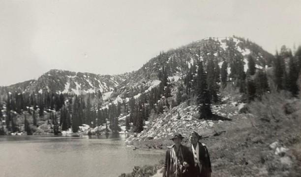
    <summary type="html"><![CDATA[<p><strong><em>Nestled in the mountains of northeast Utah, Camp Cloud Rim has been a place of refuge, belonging, and adventure to Girl Scouts for nearly a hundred years. Rising like a phoenix from its ashes at the turn of the century, the camp stands as a testament to the strength and kindness of its community. </em></strong></p><img src="https://www.intermountainhistories.org/files/fullsize/86286387e18e803da26bda97432f9ba9.jpg" alt="Two girl scouts posing in front of Lake Brimhall and the Wasatch Mountain Range." /><br/><p><span style="font-weight:400;">Camp Cloud Rim, originally called “Camp Pinar,” was constructed in 1934 with funding and labor provided by Franklin Roosevelt’s New Deal program. In 1937 the camp was officially dedicated to the Girl Scouts of America and renamed Camp Cloud Rim. While the camp is still up and running nearly a century later, its survival has been no easy feat. Following several catastrophic events the camp continues to be revived by the driven community which surrounds it. </span>
<span style="font-weight:400;"></span><span style="font-weight:400;">Located in the Wasatch Mountain Range, just outside of Park City, much of the community surrounding Camp Cloud Rim in the early days came from local mining camps. Barbara Schmidt, a lifelong scout, remembers attending the camp in the late 1940s. She has fond memories of her summers at camp which were spent swimming in Lake Brimhall, making pull taffy, developing wilderness survival skills, and forming some of the most meaningful friendships she’s ever had. One of Barbara’s first and dearest friends at the camp was a local girl whose father had died in the mines. As she returned each year she made more friends from around the state, many of whom were from mining communities, and some of which she kept in touch with by exchanging letters over the winter and even after they had aged out of camp. </span>
<span style="font-weight:400;">The trips up to camp each summer were infamous for their chaos. The road up the mountain was winding and bumpy, a journey not made any more pleasant by the old bus that carried them. Barbara recalls frequent transmission issues that sometimes stranded them on the mountain for long periods of time. </span>
<span style="font-weight:400;"></span><span style="font-weight:400;">While camp transportation has improved over the years, many aspects of camp culture from the early years live on today. Choosing a new name to go by at camp has been a common practice across the United States for decades, a tradition upheld by both the leaders and campers of all ages at Camp Cloud Rim. For many girls, camp is an opportunity to be braver, bolder, and more adventurous than they usually would be. With their new aliases, often chosen from favorite cartoon characters or fairytale heroines, they have the freedom to reinvent themselves. Like Barbara and her friends in the 1940s and 50s, girl scouts today enjoy recreational lake activities, learning survival skills, and experiencing their first taste of independence. </span>
<span style="font-weight:400;"></span><span style="font-weight:400;">In late November 1992 a fire spread throughout the camp destroying the main lodge and most of the other structures on property. The winter conditions made a trek up the mountain impossible, so the county sent helicopters to extinguish the fire. In just under six years the damaged property was brought back to life through the tireless efforts of community volunteers, fundraising efforts, and a generous benefactor––Janet Quinney Lawson, a philanthropist and lover of the outdoors. Camp Cloud Rim was reopened in 1999 and it continues to cultivate meaningful relationships and experiences for girls today, just as it did for Barbara and her friends back in the 40s. </span></p><p><em><strong><a href="https://www.intermountainhistories.org/items/show/926">For more (including 5 images) view the original article</a></strong></em></p>]]></summary>
    <published>2025-12-09T17:24:31+00:00</published>
    <updated>2026-04-17T19:32:21+00:00</updated>
    <link rel="alternate" type="text/html" href="https://www.intermountainhistories.org/items/show/926"/>
    <id>https://www.intermountainhistories.org/items/show/926</id>
    <author>
      <name>Megan Bailey, Brigham Young University</name>
    </author>
  </entry>
  <entry>
    <title type="html"><![CDATA[Thomas Rhoads, The Forgotten Mormon<br />
]]></title>
    <summary type="html"><![CDATA[<img src="https://www.intermountainhistories.org/files/fullsize/8270cbc2aff28b5cd485285278466bee.jpg" alt="Map demonstrating the “Old Spanish Trail” initially used by Colonial Spanish in the late sixteenth century." /><br/><p><span style="font-weight:400;">Born in 1796 in Kentucky, Thomas Rhoads fought for the U.S. Army in the War of 1812. Marrying his first wife Elizabeth Forter in 1817, having sixteen children together, he then converted to The Church of Jesus Christ of Latter-day Saints in Nauvoo, Illinois, in 1835. Rhoads belonged to the Danites and to the Nauvoo Legion as Lieutenant. He moved his family from Illinois to Missouri and finally to California. Rhoads led the first LDS pioneers into future Utah Territory in 1846, before continuing west into California, where he struck gold. After Samuel Brannon refused church leaders’ call to return to Great Salt Lake City, Brigham Young wrote to Rhoads asking him to lead members and tithes back to Salt Lake.</p> <span style="font-weight:400;">Arriving in 1849 at the head of a wagon train, the Saints hailed Rhoads as a hero in a parade wherein Young spoke of Rhoads’ vital contributions of gold to the territory. Submitting four thousand dollars’ worth of gold members had sent as tithing, Rhoads then gave his own seventeen thousand dollars of gold. In exchange Rhoads was given an exceptional plot of land near the temple in Salt Lake and credited with over ten thousand dollars in the church bank ledger, the only man to receive his own dedicated page in the ledger aside from Brigham Young himself.</p> <span style="font-weight:400;">Rhoads served Brigham Young in many ways to help establish Utah Territory’s economic footing over the coming years. Young handpicked Rhoads multiple times to accompany him on scouting parties around the state to determine future settlements. Furthermore, Rhoads continued to provide a steady supply of gold each year to the Mormon mint. Multiple primary sources describe his deliveries in person; however, the church ledgers do not record the deposits, and scholars debate the amounts. Ultimately, the income was crucial to the young community facing extreme opposition as minted gold coins contributed to the perpetual immigration fund as well as construction of the temple.</p> <span style="font-weight:400;">Just as the amount is contested, so are the various sources. Accounts detail how Rhoads knew about a multitude of old mines in the mountains, abandoned by the Spanish. Several of these mines have been located and confirmed, others were claimed to have been found but were not accessible, while others still are lost. Most controversial amongst these is “Carre Shin Ob” located near White Rocks Canyon in the Wasatch Forests of Eastern Utah. As the story goes, in 1852 Brigham Young and Utes Chief Walker entered an arrangement thanks to Isaac Morely, wherein Rhoads would be permitted to travel alone deep into Indian territory to retrieve gold for the Mormon church. Walker was a convert and believed in the church, giving three simple rules: only Rhoads may know the location, he only takes the specified amount, and no Ute Indians would transport gold.</p> <span style="font-weight:400;">Dozens of accounts detail Rhoads’ travels; and the days absent compared to confirmed distance traveled proves wherever Rhoads retrieved gold from, he did not have to mine it himself. Scientific analysis of remaining Mormon mint coins matches the chemical makeup of old Spanish gold mined in the era. There are critiques that doubt the stories of Rhoads’ lost mine; regardless, Rhoads gathered gold from somewhere and this gold was immensely important to the foundation of Salt Lake City and eventually Utah.</span></p><p><em><strong><a href="https://www.intermountainhistories.org/items/show/877">For more (including 4 images) view the original article</a></strong></em></p>]]></summary>
    <published>2025-01-25T03:15:14+00:00</published>
    <updated>2026-04-17T19:32:20+00:00</updated>
    <link rel="alternate" type="text/html" href="https://www.intermountainhistories.org/items/show/877"/>
    <id>https://www.intermountainhistories.org/items/show/877</id>
    <author>
      <name>Travis Sorensen, Brigham Young University</name>
    </author>
  </entry>
  <entry>
    <title type="html"><![CDATA[The Short and Storied History of The Colored Citizen]]></title>
    <summary type="html"><![CDATA[<p><strong><em>In 1884, the <em>Colored Citizen</em> became the first African American newspaper to be published in Montana. This newspaper is credited with helping Helena become the capital city of Montana. Additionally, while this newspaper was short-lived, it set the foundations for the other African American newspapers that followed.</em></strong></p><img src="https://www.intermountainhistories.org/files/fullsize/768f6a0faac6043afd8ad289535d1d70.jpg" alt="[Untitled]" /><br/><p><span style="font-weight:400;">In the early 1880s, a fight erupted in Montana over the location of the state capital. William Andrews Clark and Marcus Daly, the biggest names in the Montana copper industry, each wanted their local city to become the capital. While Daly preferred his beloved Anaconda, Clark fought to make the upstart mining city of Helena the capital. As part of the campaign to persuade voters to select Helena, he created and funded </span><i><span style="font-weight:400;">The</span></i> <i><span style="font-weight:400;">Colored Citizen</span></i><span style="font-weight:400;">. Clark was known as a famous entrepreneur, the “Copper King of Montana,” and as one of the wealthiest men in the United States during the late nineteenth century. He spent over $200,000 supporting the newspaper during its short run from September-November 1894, which was during the campaign season. James Presley Ball Jr. was named editor of the newspaper. Ball Jr. was also a photographer, and he represented a variety of African Americans who migrated to Helena in the 1880s in search of better treatment. He published the newspaper at 137 N. Main St, which is in the downtown area of the city. </span>
<span style="font-weight:400;">The </span><i><span style="font-weight:400;">Colored Citizen</span></i><span style="font-weight:400;">’s opening issue discussed the purpose of the paper. According to the Library of Congress, “Its reason for being was the intense interest among the city’s 279 ‘Colored’ Citizens in the upcoming election to decide the site of the state capital: Helena or Anaconda.” This issue also stated that Montana should be immensely proud of all of its “Colored Citizens.” During 1884, African Americans represented around 1% of the total state population with about 1,500 citizens. Additionally, the </span><i><span style="font-weight:400;">Colored Citizen </span></i><span style="font-weight:400;">had stories and articles about news on the local and state level. The newspaper was four pages long, with six columns. </span>
<span style="font-weight:400;">In the final issue of the newspaper on November 5th, 1894, a full-page endorsement filled the front page. It stated, “The Anaconda Mining Company Does Not Employ a solitary Colored man. Dagoes and Foreigners are preferred to Native Colored Americans. Helena has 500 Prosperous Colored Citizens. They own Thousands of Dollars of Real Estate and are Engaged in every kind of Business. Colored Men of Montana stand by your Helena Brethren. Vote for HELENA for the CAPITAL.” Unfortunately, the newspaper was shut down shortly before the vote, which ended up coming down to the wire. With a narrow gap of less than 2,000 votes out of the 50,00 votes cast, Helana won. The </span><i><span style="font-weight:400;">Colored Citizen</span></i><span style="font-weight:400;">’s influence on the vote is immeasurable, and its work to make Helena the capital has impacted Montana to this day. The newspaper also laid the groundwork and foundation for the African American newspapers that followed. </span><span style="font-weight:400;"> </span></p><p><em><strong><a href="https://www.intermountainhistories.org/items/show/871">For more (including 4 images) view the original article</a></strong></em></p>]]></summary>
    <published>2024-10-22T21:23:11+00:00</published>
    <updated>2026-04-17T19:32:19+00:00</updated>
    <link rel="alternate" type="text/html" href="https://www.intermountainhistories.org/items/show/871"/>
    <id>https://www.intermountainhistories.org/items/show/871</id>
    <author>
      <name>Morgan Baird, Rocky Mountain College  </name>
    </author>
  </entry>
  <entry>
    <title type="html"><![CDATA[Molly Brown: The &quot;Unsinkable” Suffragist and Workers’ Rights Activist]]></title>
    <summary type="html"><![CDATA[<p><strong><em>Famously called the “Unsinkable Molly Brown” for surviving the Titanic, the suffragist had a remarkable life before and after the tragedy.</em></strong></p><img src="https://www.intermountainhistories.org/files/fullsize/8513fb5a82d7726a5750959d63e83e46.jpg" alt="Portrait of Margaret “Molly” Brown" /><br/><p><span style="font-weight:400;">Margret Tobin Brown was born in Hannibal, Missouri in 1867 to Irish immigrants. Life in Hannibal greatly influenced her outlook, as she was surrounded by diversity and saw the struggles of the working class. Her parents valued education, so Margaret was able to attend school until she was 13 when she had to drop out to work in a factory. Like her father and countless others, she experienced low wages, instability, and dangers at work. </span>
<span style="font-weight:400;">Margaret dreamed of going West, and at age 18, she followed one of her older brothers, Daniel, who had moved to Leadville, Colorado, to strike rich in the mines. Women were not allowed to work in the mines, so they had to find jobs in the mining towns, as cooks, nurses, saloon girls, or store workers. Margret worked in a store, and while she did not have much, she participated in causes she believed in, like volunteering in soup kitchens.</span>
<span style="font-weight:400;">It was in Leadville that she met her husband James Joseph Brown, a mining engineer. They got married in 1886 and soon had two children. Surprisingly, in 1893, they became millionaires when the Little Jonny Mine that J.J. invested in struck gold. Now wealthy, they moved their family and built their home in Denver, Colorado which can be visited today. </span>
<span style="font-weight:400;">They became prominent figures in Denver, Margaret in the political realm and J.J. in the business sphere. Denver was rampant with various social issues—poverty, homelessness, and workers’ rights issues—and now Brown held a position where she could promote political action. She advocated for labor reform and became an involved member of the National American Women’s Suffrage Association (NAWSA). </span>
<span style="font-weight:400;">Margaret’s situation was unique because she separated from her husband in 1909 to live independently. In 1912, she embarked on the Titanic. When tragedy struck, she was pushed onto a lifeboat, even though she was still trying to help others. After the lifeboat was deployed, she protested, saying they needed to save more people, but the sailor refused. Although not allowed to testify in court because she was a woman, she became one of the most famous survivors. </span>
<span style="font-weight:400;">With her newfound fame after the Titanic, Brown used her position to raise awareness of the Ludlow Massacre of Colorado miners, who were striking for more rights. She understood the challenges workers and families faced, so she not only helped the affected families but also advocated for workers' rights and spoke about how women having the right to vote could help pass necessary reforms across the country. </span>
<span style="font-weight:400;">Brown did important work for Colorado and people began encouraging her to run for Congress in 1914. However, with growing tensions with World War, she decided not to run and shifted her focus to war relief programs. She became the self-sufficient woman of the 1920s, continuing to advocate for women’s and laborer’s rights until her death on October 26, 1932. </span></p><p><em><strong><a href="https://www.intermountainhistories.org/items/show/864">For more (including 4 images) view the original article</a></strong></em></p>]]></summary>
    <published>2024-10-18T23:42:20+00:00</published>
    <updated>2026-04-17T19:32:19+00:00</updated>
    <link rel="alternate" type="text/html" href="https://www.intermountainhistories.org/items/show/864"/>
    <id>https://www.intermountainhistories.org/items/show/864</id>
    <author>
      <name>Rosalyn Visser, Rocky Mountain College</name>
    </author>
  </entry>
  <entry>
    <title type="html"><![CDATA[The KKK in Butte, Montana]]></title>
    <summary type="html"><![CDATA[<p><strong><em><span style="font-weight:400;">Taking advantage of existing tensions between Protestants and Irish Catholics in Butte, Montana, the Ku Klux Klan sought to penetrate the community and hoped to stoke discourse.</span></em></strong></p><img src="https://www.intermountainhistories.org/files/fullsize/23f3a64865731d1aad110432024680ba.jpg" alt="Undated photograph of Elm Orlu mine" /><br/><p><span style="font-weight:400;">Before the arrival of the Ku Klux Klan in 1923, tension between Protestants and Catholics existed in the mining communities of Butte, Montana. The so-called “War of the Copper Kings” was a feud between mine owners Marcus Daly and William A. Clark during an 1888 campaign for territorial representation of the companies. Although both were Irish, Clark was a Protestant while Daly was a fervent Catholic. Many of the miners were migrant Irish-Catholics and Daly won the election. Clark never forgot the loss and battled for control until he died in 1900. It was also during this period that a group known as The American Protective Association (APA) gained popularity in Butte. The APA was an organization that was extremely anti-Catholic and members frequently got into violent altercations with Catholics at local bars.   </span></p><p><span style="font-weight:400;">Furthermore, due to issues such as decreased copper demand following the end of the First World War, many in Montana felt economically unstable and wary of foreigners. When the Ku Klux Klan arrived in Butte in the 1920s, it hoped to exacerbate the existing religious tensions and economic fears by using Irish Catholic workers as scapegoats. </span>
<span style="font-weight:400;">Originally gaining popularity in Billings, the Klan sought to move into Butte. However, as Butte historian Christine Erikson notes, “Catholic Immigrants cared little for an organization that referred to the Pope as an ‘impatient, meddling individual controlled by a Jesuitical lot of assaassainous villains.’” The Klan notably chose to act in an especially clandestine manner while conducting operations in Butte. Local Klansmen moved from town to town and conducted meetings under various aliases such as the “Protestant Men’s Welfare Council” and “Butte Men’s Literary Club.” Klan officers also urged other chapters in Montana to avoid exposing Butte Klansmen by ensuring that any mail to members in Butte didn’t indicate anything that suggested a Klan association. It is estimated that at least 181 residents of Butte joined the organization during 1923-1929, including 39 who worked as miners and on rail lines for Clark. </span>
<span style="font-weight:400;">The reasons for their especially secretive nature are not completely clear. The Butte Klan could have been worried about backlash from other Protestant organizations that operated in the area such as Masonic groups. It is also possible that other Butte clandestine organizations were not eager to associate with a group that was gaining a national reputation for terrorism. Another reason could be that in a town with a sizable Irish-Catholic population, the Klan worried about community backlash. Butte’s </span><i><span style="font-weight:400;">Labor Bulletin </span></i><span style="font-weight:400;">heavily criticized the Klan in Butte and proclaimed, “Their Invisible Empire Should Have No Place in These United States.”</span>
<span style="font-weight:400;">The Klan's larger efforts in Butte eventually proved to be fruitless—the membership and public activity essentially became dormant by the 1930s. Instead, the Klansmen opted to do smaller acts such as “guarding” voting booths and writing opinion pieces in editorials about unfavorable politicians. However, most of their Butte activities seemed to be brooding in their meeting places and discussing inter-Klan politics. </span></p><p><em><strong><a href="https://www.intermountainhistories.org/items/show/811">For more (including 3 images) view the original article</a></strong></em></p>]]></summary>
    <published>2024-05-21T00:10:52+00:00</published>
    <updated>2026-04-17T19:32:18+00:00</updated>
    <link rel="alternate" type="text/html" href="https://www.intermountainhistories.org/items/show/811"/>
    <id>https://www.intermountainhistories.org/items/show/811</id>
    <author>
      <name>Aidan Capristo, Northern Arizona University</name>
    </author>
  </entry>
  <entry>
    <title type="html"><![CDATA[The Yankee Fork Mining District]]></title>
    <summary type="html"><![CDATA[<p><strong><em><span style="font-weight:400;">Custer County, Idaho is home to one of the best preserved gold dredges in the country–and a rich mining history that ushered in new life and opportunity. </span></em></strong></p><img src="https://www.intermountainhistories.org/files/fullsize/f3100d51405a82a8c2925197e302b71a.jpg" alt="Yankee Fork Gold Dredge" /><br/><p><span style="font-weight:400;">Placer gold, extractable by hand with little equipment, was discovered in Idaho in 1860 by E. D. Pierce. Pierce became fixated with the idea of mining on the Nez Perce territory in Northern Idaho and corners of Washington and Oregon. He eventually disregarded the law which prohibited mining on Native American lands and chose to proceed with his plans, launching the region into a new era of exploration, excavation, and the boomtowns that sprouted up in response.</span>
<span style="font-weight:400;">Previous to the discovery of gold, settlements in the region were largely made up of various Christian missionary enterprises and Mormon communities. Congregationalist-Presbyterians and Catholics were among the first to travel to Idaho in the 1830s, introducing christianity to the Nez Perce and establishing settlements in the area. Groups of Mormon settlers traveled north from the Salt Lake Valley into what would become Idaho, first in 1855, and progressively more in the following years. </span>
<span style="font-weight:400;">Idaho became a U.S. territory in 1863, and there was growing interest in the land for more than just religious reasons. As gold speculators made their way through the territory they found vast riches around Yankee Fork, a river in central Idaho’s Custer County. It wasn’t long until a mining district–a section of rural land designated for mining–was established around the river. By 1882, annual gold and silver production in Idaho had reached 3.5 million dollars, and one-third of that profit came from placer deposits in the rivers of Custer County. Additionally, there was an abundance of ore, another source of wealth for hardrock mining in Idaho. However, many of these spoils were in the riverbed which made them difficult to extract without the proper equipment. </span>
<span style="font-weight:400;">The Yankee Fork Mining District is most famous for its dredge, designed to extract gold and silver from riverbeds. The use of industrial machines, rather than physical labor, was first introduced in the late nineteenth century–but it wasn’t until 1940 that the construction of the Yankee Fork Gold Dredge was complete. It was no small enterprise at 112.5 feet long and 64 feet high, with a bucket system and sluice boxes to collect and sift through elements. Even though mining stopped during World War II due to the nationwide ban on non-essential mining, work at the dredge picked up again in 1946. The second stint didn’t last long; the dredge was shut down for good in 1952 when the once abundant minerals ran dry. Although it operated for less than ten years, the Yankee Fork dredge managed to produce over 1 million dollars. Today it is a site for summer tourists and one of the best preserved dredges in the U.S. Although a relic of the past, Custer County is still host to 952 mines for the extraction of silver, gold, lead, zinc, and copper.  </span></p><p><em><strong><a href="https://www.intermountainhistories.org/items/show/804">For more (including 5 images) view the original article</a></strong></em></p>]]></summary>
    <published>2024-05-16T01:28:14+00:00</published>
    <updated>2026-04-17T19:32:17+00:00</updated>
    <link rel="alternate" type="text/html" href="https://www.intermountainhistories.org/items/show/804"/>
    <id>https://www.intermountainhistories.org/items/show/804</id>
    <author>
      <name>Megan Bailey, Brigham Young University</name>
    </author>
  </entry>
  <entry>
    <title type="html"><![CDATA[ Mountains, Mining, and Massacre: The History of Oatman, Arizona]]></title>
    <summary type="html"><![CDATA[<p><strong><em><span style="font-weight:400;">Free-roaming donkeys, an old mining district, a stop on Route 66, and ties to a famous kidnapping make up the storied past of this semi-abandoned town.</span></em></strong></p><img src="https://www.intermountainhistories.org/files/fullsize/d34d919e9df93dc8bb5d0f3e2ba0cc1d.jpg" alt="Oatman, Arizona circa 1930." /><br/><p><span style="font-weight:400;">Tucked away in the Black Mountains of Mohave County, Arizona is a community rich with legend. The town was named for Olive Oatman and her family who were victims of the Oatman Massacre in 1851, and it came to life in the following decades as prospectors discovered gold, ore, and other valuable resources in the land. Oatman is home to the three most prosperous gold mines in Arizona: the Gold Road, the Tom Reed, and the United Eastern. </span>
<span style="font-weight:400;">A gold prospector named John Moss was one of the first to discover gold in the area in the early 1860s, but it wasn’t until the 1900s that Oatman really boomed. A hotel and post office were built in 1902 and 1906 respectively, securing Oatman’s status as an official town. The mines brought riches and rapid growth to the community, with Tom Reed mine’s total profit reaching over nine-million by 1922 and the town’s population growing to 10,000 in the same decade.</span>
<span style="font-weight:400;">One of the oddities of Oatman is the population of wild burros (undomesticated donkeys). They were brought in by miners who used teams of them to haul supplies from out of town. Burro labor was a big part of the mining industry, but unlike the prospectors, they never picked up and left town. Billie Jo Moore, long time proprietor of the Oatman Hotel, said in an interview that, “the burros stayed behind and adapted to the desert. Now they are all over these mountains…They wander through the streets, turning over garbage cans and messing in people’s yards.” While they are little more than a nuisance to locals, tourists entertain them with attention, alfalfa pellets, and lots of pictures–burros have become iconic to the town. </span>
<span style="font-weight:400;">Oatman stitched itself into another legend of America when it became a part of Route 66. It was 1926, still bringing in plenty of spoils from the mines, and now gaining further revenue from the new highway. These were the glory days in Oatman; crime was low, employment was high, and people were optimistic about the future. While there was an occasional murder and a tendency for drunkenness in Oatman, it didn’t fall into the expected stereotype of the “wild west.” The isolation of the town, so far away from any other civilization at that time, created a tight-knit group that made new traditions together–like the annual three day long Fourth of July celebrations. When the Great Depression hit in the 1930s, the prosperity and liveliness of the community began to dwindle, and by the time Route 66 went out of commission in the 1950s it was well on its way to becoming a ghost town. Oatman has never been fully abandoned though, and it has been given new life through its performers and curious travelers. </span></p><p><em><strong><a href="https://www.intermountainhistories.org/items/show/802">For more (including 5 images) view the original article</a></strong></em></p>]]></summary>
    <published>2024-05-16T00:49:23+00:00</published>
    <updated>2026-04-17T19:32:17+00:00</updated>
    <link rel="alternate" type="text/html" href="https://www.intermountainhistories.org/items/show/802"/>
    <id>https://www.intermountainhistories.org/items/show/802</id>
    <author>
      <name>Megan Bailey, Brigham Young University</name>
    </author>
  </entry>
  <entry>
    <title type="html"><![CDATA[Golden: A Ghost Town]]></title>
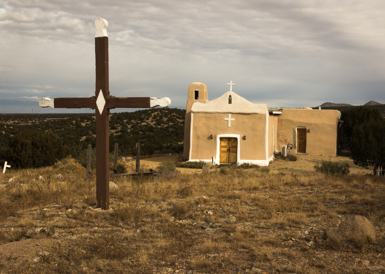
    <summary type="html"><![CDATA[<p><strong><em><span style="font-weight:400;">In an overgrown cemetery, amidst tombstones and memorabilia, a child’s white metal bed frame sits above a grave. Golden, New Mexico–population zero–is a ghost town in more ways than one. </span></em></strong></p><img src="https://www.intermountainhistories.org/files/fullsize/e67fd8700f683d9e53b557c2c957ca2f.jpg" alt="San Francisco de Asis Catholic Church" /><br/><p><span style="font-weight:400;">Today the tiny Santa Fe community of Golden is known for the gold rush that it was named for, but before the gold Navajo peoples found prosperity in turquoise. The road running from Albuquerque to Santa Fe, which is now part of New Mexico 14, is still aptly referred to as the “Turquoise Trail.” In the 14th century Spanish Conquistadors made their way to the region of Mexico that would later become New Mexico and Arizona. For several hundred years they traded goods, mined, and colonized the land. </span>
<span style="font-weight:400;">It is said that the gold rush didn’t really begin in New Mexico until it was declared an American state, but nearly one-hundred years earlier in 1825 the community of Golden had its day in the sun. When Mexico gained independence from Spain in 1821, the Santa Fe trail became open to Americans for trading purposes–creating an influx of American settlers to the area, who had been few and far between during the Spanish years. Trading opportunities, cattle herding, gold, and the exciting prospect of “new” land drew Americans in from surrounding U.S. territories and states. Gold was discovered in the land just north of the San Pedro mountains and a mining district blossomed. Within the next few decades a general store, a post office, a public school, and quite a few saloons, were built as well as a Catholic church–which is now the most photographed church along the Turquoise Trail. </span>
<span style="font-weight:400;">San Francisco de Asis Catholic Church, named after Saint Francis of Assisi, was built around 1830. The adobe brick plaster makeup of the church has held up well over the years, and the white painted crosses still look as bright as ever. The churchyard is home to the bodies of those who died in the fleeting time of Golden’s own “life.” Although the church provides a glimpse into the past, it isn’t completely dormant. Beloved by those who explore the grounds on their way through town, and welcoming to Sunday tourists who attend church services.</span>
<span style="font-weight:400;">The era of growth and excitement in the community was short-lived and ended almost as suddenly as it had begun. When the 1825 gold rush era ended, there was little reason to stay. The few who remained resorted primarily to agriculture to make their living. There was a dwindling and largely fruitless attempt by some remaining residents to dig up the last of the gold, but there was only so much to be found before even the most stubborn of them abandoned the pursuit. A hundred years after the initial gold rush there were so few people remaining that Golden lost its township status. In 2021 the census reported a population of zero residents of Golden, but the Turquoise Trail continues as a scenic route for road trips and the church with its overgrown cemetery stands as a monument–a living memory of all that once was. </span></p><p><em><strong><a href="https://www.intermountainhistories.org/items/show/799">For more (including 5 images) view the original article</a></strong></em></p>]]></summary>
    <published>2024-05-15T19:52:11+00:00</published>
    <updated>2026-04-17T19:32:17+00:00</updated>
    <link rel="alternate" type="text/html" href="https://www.intermountainhistories.org/items/show/799"/>
    <id>https://www.intermountainhistories.org/items/show/799</id>
    <author>
      <name>Megan Bailey, Brigham Young University</name>
    </author>
  </entry>
  <entry>
    <title type="html"><![CDATA[Frisco and the Horn Silver Mine]]></title>
    <summary type="html"><![CDATA[<p><strong><em>The city of Frisco, Utah is just a ghost town now, with most of its remains carried away by scavengers and the leftover pieces strewn across the ground. But in 1885, it was the largest settlement in the southern Utah Territory. At the peak of the mining boom it had a population of around 4,000 people, at a time when less than 1,500 people lived in St. George. During the 1880s, prospectors extracted about 1.5 million troy ounces of silver from the Horn Silver Mine on a yearly basis. It also gained a reputation as one of the wildest towns of the West, populated by desperate and violent characters and scoundrels looking to make a quick buck.</em></strong></p><img src="https://www.intermountainhistories.org/files/fullsize/c36139e82fd53abfa94296f7cb67bdff.jpg" alt="Site of Horn Silver and King David Mines" /><br/><p><span style="font-weight:400;">Frisco, named for the San Francisco mountains which it borders, saw prospectors making claims in the area as early as 1871, but it was the discovery of the Horn Silver Mine in 1876 that sparked the biggest mining rush since the discovery of the Comstock Lode. According to legend, two prospectors stopped for lunch near a limestone outcropping of Grampian Hill, and one of the men tapped on a small boulder with his pick, accidentally breaking a large chunk of rock free. To his surprise, the rock was filled with silver so soft he could cut it with his knife.</span>
<span style="font-weight:400;"><span style="font-weight:400;">The Horn Silver bonanza created a powerful draw for men looking to find a claim of their own or those that sought employment within the huge mine and its related processing works. Even though the trans-continental railroad was completed in 1869, Frisco and the Horn Silver mine remained disconnected from the railroad for their first five years, and conditions in the region were largely inhospitable. The water from the San Francisco Mountains is muddy, and streams and springs flow only seasonally, so Frisco was forced to shipp its water supply from Milford, 15 miles to the southeast.</p></span>
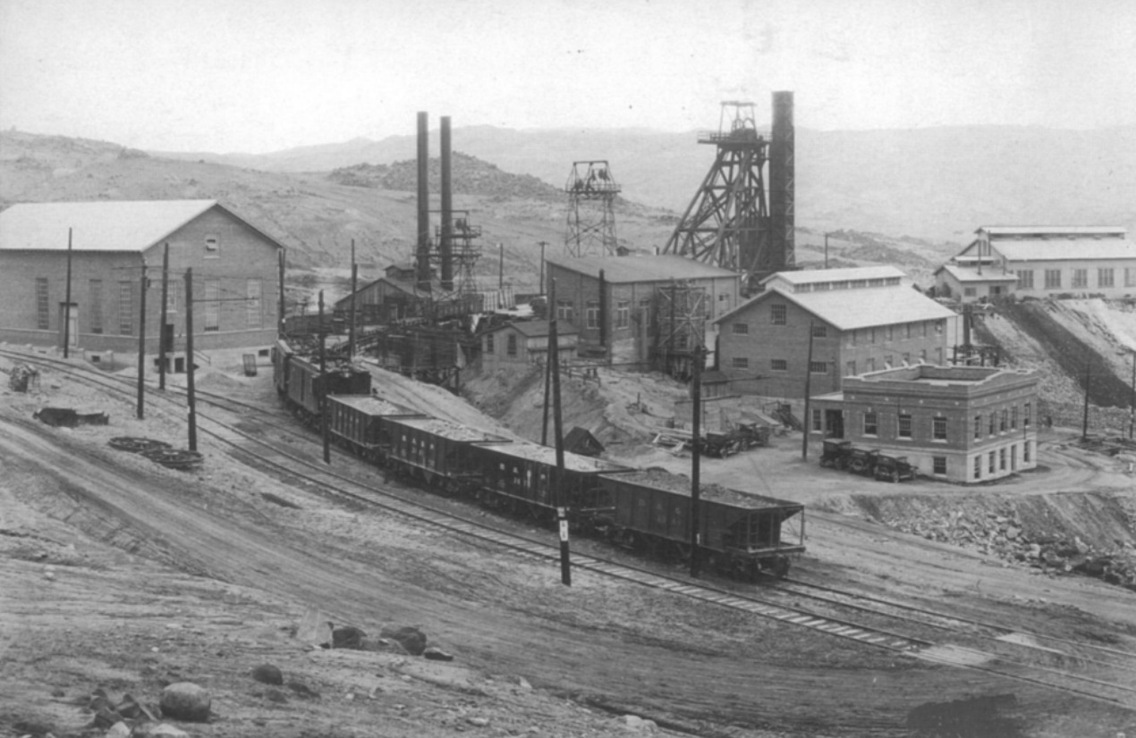
<span style="font-weight:400;">With limited access to coal and charcoal, investors built great charcoal smelting plants to make fuel. In addition to the five great kilns still visible from the highway, an additional 24 kilns are in various clusters northeast of town. While the remains of these kilns look like primitive, oversized stone beehives, the kilns are the surviving parts of sophisticated plants once filled with cutting-edge 1880s equipment: blowers, boilers, steam engines, and a reverberatory flue-dust slagging furnace. When the mine closed down, the investors removed and recycled the steel and iron equipment, and left only the heavier stone kilns.</span>
<span style="font-weight:400;">The need for workers to operate the mines and their supporting operations brought all kinds of characters to town, and the streets filled with saloons and brothels. The local newspaper editor, Charles King, described the town as “Dodge city, Tombstone, Sodom and Gomorrah, all rolled into one.”</span>
<span style="font-weight:400;">The most repeated story of Frisco violence concerns Sheriff Pearson, who allegedly took the job to clean up the town’s wild ways. Instead of building a jail and setting up a traditional justice system, Pearson threatened the town’s miscreants with exile or a shootout. On his first night on the job, he allegedly shot six men, and would regularly dispatch a “meat wagon” to cart those who “died with their boots on” to their unmarked graves.</p><p>The Horn Silver mine collapsed on February 12, 1885, bringing an end to the silver rush, and the town soon numbered in the hundreds rather than the thousands. Even though a new shaft was built at Horn Silver and the mine soon became productive again, the boom and the era of finding a million ounces of silver a year were over. The mining works and the town slowly faded away, and in 1928, the last Friscoians left town. The mines, including the more recent King David shaft, continued work intermittently until 1952. The Horn Silver Mines company still “explores” the area for minerals, but the mines of Frisco have remained quiet for 80 years.</p></p><p><em><strong><a href="https://www.intermountainhistories.org/items/show/744">For more (including 5 images) view the original article</a></strong></em></p>]]></summary>
    <published>2023-04-11T15:57:52+00:00</published>
    <updated>2026-04-17T19:32:16+00:00</updated>
    <link rel="alternate" type="text/html" href="https://www.intermountainhistories.org/items/show/744"/>
    <id>https://www.intermountainhistories.org/items/show/744</id>
    <author>
      <name>Andrew Durbin, Brigham Young University </name>
    </author>
  </entry>
  <entry>
    <title type="html"><![CDATA[Emma Silver Mine at Alta <br />
]]></title>
    <summary type="html"><![CDATA[<p><strong><em>Every winter thousands of powder-seeking skiers make the trek up Little Cottonwood Canyon to ski at the acclaimed Alta Resort. Their journey mirrors a similar one taken one hundred years prior by miners who rushed up the canyon to mine  silver. During this bonanza, miners created the City of Alta while working at the Emma Silver Mine. </em></strong></p><img src="https://www.intermountainhistories.org/files/fullsize/722c2a6faebb6607e91c6bc7b4a584ed.jpg" alt="Emma Mine in 1873" /><br/><p><span style="font-weight:400;">Only a few miles southeast of Salt Lake City on the Wasatch Front stands Little Cottonwood Canyon, forged by a giant alpine glacier. Soon after arriving at the Salt Lake Valley, the pioneers quickly sought to explore their new home, including the canyon. Up until the 1860s, there had been very little mining done in the Salt Lake Valley apart from the quarrying near the mouth of Little Cottonwood Canyon. However, the 1863 discovery of ore in Bingham Canyon, directly west from Little Cottonwood Canyon, led to an increase in mining and prospecting throughout Utah. The discovery piqued interest in prospecting and led to the subsequent discovery of silver in 1864 in Little Cottonwood Canyon. The details surrounding the first silver strike are vague, but the stunning reaction to the ore is not. </span>
<span style="font-weight:400;">After the discovery, miners quickly petitioned for a new mining district, which eventually led to the creation of the Little Cottonwood Mining District. With a proper mining district in place, the miners of Salt Lake City began frantically searching for deposits all along the Wasatch Range. Eventually, the miners struck a lode brimming with silver about nine miles up the canyon. The continual influx of miners led to the creation of a small mining city in 1865 that they named Alta, due to the high elevation of the city. The miners also named the mine itself the Emma Mine. </span>
<span style="font-weight:400;">Miners continued to profit from the Emma Silver Mine during the end of the 1860s but still required financing from investors to support the operation. Owners of the Emma Mine looked to sell ownership to British investors in accordance with common practice of the time. In 1871, Senator William M. Stewart and James E. Lyon attempted to sell the mine for an estimated $1.5 million. To portray the mine as profitable, Stewart and Lyon sent falsified estimates and production numbers that hid the reality of the declining profitability of the mine. They even went as far as to have Robert C. Schenck, a U.S. ambassador, promote the quality and profitability of the Emma Mine to English investors. Eventually the mine sold for $5 million to English investors, and even after an investigation, Congress did not charge any individual with criminal offense. </span>
<span style="font-weight:400;">The obvious lack of ore within the region led to a decrease in production and relevance of the mine. Additionally, a massive fire destroyed the mine and most of the City of Alta in 1878. Then in 1885, an avalanche leveled the town once again during one of Utah’s intense winters. By the turn of the century, the already small mining town of Alta had greatly diminished and by the 1930s, only one resident remained, George Watson. Watson eventually sold his land in the canyon to the U.S. Forest Service who had plans to develop the area into a ski resort with the help of skiing legend Alf Engen. By 1938, they built the first ski lift, and the city began to grow once again, this time as a resort city instead of a mining town. </span></p><p><em><strong><a href="https://www.intermountainhistories.org/items/show/740">For more (including 3 images) view the original article</a></strong></em></p>]]></summary>
    <published>2023-04-07T19:03:31+00:00</published>
    <updated>2026-04-17T19:32:16+00:00</updated>
    <link rel="alternate" type="text/html" href="https://www.intermountainhistories.org/items/show/740"/>
    <id>https://www.intermountainhistories.org/items/show/740</id>
    <author>
      <name>William Howarth, Brigham Young University</name>
    </author>
  </entry>
  <entry>
    <title type="html"><![CDATA[Chinden Boulevard: Remembering Chinese Contributions to Boise]]></title>
    <summary type="html"><![CDATA[<p><strong><em>Many residents of Idaho’s capital know the name “Boise” comes from the French word for “wooded,” but will those who call “The City of Trees” home recognize another familiar name in the valley that recalls Idaho’s storied past as a culturally diverse frontier territory?</p></strong></p><img src="https://www.intermountainhistories.org/files/fullsize/a9f4450a4cbf7c33cbfa46eac170c193.jpg" alt="A Festival on Chinden" /><br/><p><span style="font-weight:400;">“Chinden Boulevard,” or US Highway 20/26 is a vital East-West artery of the Boise metropolitan area which connects suburban homes to the workplaces, restaurants, and entertainment centers of the capital city’s quaint downtown. Many commuters on this road, or those pleasure-seekers out for a night on the town, are, perhaps, unaware that the road’s name bears the memory of the Chinese immigrants who came to the region decades before Idaho achieved statehood. Instead of the tattoo parlors and used car lots lining the road today, near the end of the 19th century, the road passed acres of beautiful vegetable gardens planted and cared for by Chinese immigrants, thus earning the name “China-garden,” or “Chinden.”</span>
<span style="font-weight:400;">The discovery of gold in Southern Idaho in 1862 marked the beginning of a mass migration into the region that extended over the course of multiple decades and paved the way to statehood. Though united in their search for fortune and opportunity, the early prospectors and adventurers who braved this new frontier came from diverse cultural and ethnic backgrounds. One early resident of Idaho expressed his first impression of Boise in these words: “In the courtyard of the Overland Hotel I saw, the morning of my arrival in Boise, an Irishman, a Spaniard, a Frenchman, two Chinamen, a Canadian, an Englishman—and not an American.”</span>
<span style="font-weight:400;">Early Idaho was diverse and one prominent group in the cultural patchwork of the region was Chinese immigrants. In fact, in a population of about 20,600 in the territory of Idaho in 1869, 4,274 were Chinese. Though many Chinese came to the region in search of gold, over time they took up other pursuits. Indeed, it could be said that in the Idaho Gold Rush the Chinese abided by the idiom, “during a gold rush, sell shovels.” Instead of mining, many began shop keeping, cleaning laundry, raising pigs, and growing and selling vegetables to mining communities. Initially, the produce from these Chinese gardens was intended for Chinese miners, but—due to the quality and availability of the vegetables—the market quickly expanded outside Chinese circles to entire communities. The produce attracted such praise that one newspaper commented that, “most of their productions surpass in size and excellence the imported articles.” With Boise as the main supply center of the region and many Chinese looking to sell their goods and services to miner customers, many Chinese gravitated to the city, becoming a crucial part of both the city and territorial economy. In 1871, a newspaper noted that “The China population are planting gardens here pretty extensively. They are so patient and puttering that they do well.” These “patient and puttering” gardeners were known to group together to lease land for their various crops. Each took part in planting, harvesting, and selling their produce.</span>
<span style="font-weight:400;">During the growing season, work in the fields would begin before dawn. By sun-up, their carts would be loaded and ready for making deliveries to homes or selling vegetables in the streets. Another newspaper report illustrates a typical interaction between a Chinese vegetable peddler and their client: “John Chinaman makes his appearance at our door bright and early every morning, with the traditional pole and baskets, the latter filled with every variety of fresh plucked and cool vegetables.” Clearly, the Chinese presence in Boise was prominent as they filled a variety of needs for a variety of customers on a regular basis.</span>
<span style="font-weight:400;">While newspapers at times praised the industry of Chinese workers, their often patronizing tone is indicative of both the underlying and overt racism and persecution the Chinese in Idaho endured. Indeed, as far removed as the territory was, it was not far enough to escape the waves of anti-Asian legislation that spread in the wake of the Chinese Exclusion Act of 1882. After only a few decades, many Chinese left Idaho, and the once vibrant Chinese community became a shadow of what it once was. Today, Chinden Boulevard still passes through Garden City, the lowlands west of Boise’s downtown where scores of Chinese immigrants cultivated gardens to build themselves better lives. Though their exodus out of Idaho left a vacancy in Boise’s Chinese population that has not been filled since, the memory of their resolve in the face of adversity can continue to inspire generations of Idahoans as they travel along the old China-gardens road.</span></p><p><em><strong><a href="https://www.intermountainhistories.org/items/show/739">For more (including 3 images) view the original article</a></strong></em></p>]]></summary>
    <published>2023-04-07T18:08:21+00:00</published>
    <updated>2026-04-17T19:32:16+00:00</updated>
    <link rel="alternate" type="text/html" href="https://www.intermountainhistories.org/items/show/739"/>
    <id>https://www.intermountainhistories.org/items/show/739</id>
    <author>
      <name>Jacob Johnson, Brigham Young University</name>
    </author>
  </entry>
  <entry>
    <title type="html"><![CDATA[Frontier No. 1 Mine and the Explosion that Rocked Kemmerer, Wyoming]]></title>
    <summary type="html"><![CDATA[<p><strong><em>Kemmerer, Wyoming has been a mining town for over a century. In 1923, an explosion from the Frontier No.1 mine rocked the town and killed 99 men. Not only did this event leave many fatherless and widowed, but it also represented the dangers of industrialism in the early 20th century. </em></strong></p><img src="https://www.intermountainhistories.org/files/fullsize/d5a639434211920e5755e69130230de8.jpg" alt="A Brick of the Mine" /><br/><p><span style="font-weight:400;">The Kemmerer mine explosion is memorialized in a mural in the neighboring community of Diamondville. The mural is separated into several different sections and tells the history of mining in Lincoln County, Wyoming, ending with the tragic explosion in 1923. The city of Kemmerer decorates the miners’ graves every Memorial Day with  commemorative flowers. At the local museum, exhibits tell the stories of the many mines in the area, including Frontier No. 1.  </span>
<span style="font-weight:400;">John Kemmerer and Patrick J. Quealy formed a partnership that grew into four companies, including the mine. The mine opened in 1887, a mile outside of Kemmerer. For nearly a decade, the mine had no name until 1897, when Kemmerer dubbed the mine Frontier,  the same name as their supply company. At the time of the explosion, the mine produced up to 700 tons of coal a day. It also contained 30 workable areas. </span>
<span style="font-weight:400;">On August 14, 1923, Frontier No. 1 exploded and killed 99 men, the second-worst mining disaster in Wyoming history. A fire boss had tried to relight the flame of a safety lamp and accidentally ignited some nearby gas. It exploded and trapped the workers as the exits filled with rock and other debris. If the miners didn’t die from the initial explosion, then smoke or suffocating gasses, known as black damp, soon overtook them. It took 48 hours for rescuers to find the first survivors. The explosion made newspapers all over the state and became a symbol of the dangers of industrialism. Most of the men that died in the accident were immigrants from places such as South America, Italy, Japan, Australia, and Mexico. The </span><i><span style="font-weight:400;">Rock Springs Rocket</span></i><span style="font-weight:400;"> newspaper called the miners, "Martyrs to Industrialism."  The mine started back up after six months only to be shut down three or four years later. Today, the mine is buried to keep the public safe, but evidence of the explosion and the existence of the mine remains.</span></p><p><em><strong><a href="https://www.intermountainhistories.org/items/show/738">For more (including 4 images) view the original article</a></strong></em></p>]]></summary>
    <published>2023-04-07T17:30:44+00:00</published>
    <updated>2026-04-17T19:32:16+00:00</updated>
    <link rel="alternate" type="text/html" href="https://www.intermountainhistories.org/items/show/738"/>
    <id>https://www.intermountainhistories.org/items/show/738</id>
    <author>
      <name>Madison D. King, Brigham Young University</name>
    </author>
  </entry>
  <entry>
    <title type="html"><![CDATA[Anti-Chinese Riot near Virginia City, Nevada]]></title>
    <summary type="html"><![CDATA[<p><strong><em>In 1869, with anti-Chinese sentiment growing in the west, a mob in Virginia City, Nevada attempted to expel the Chinese immigrants from town. They raided the railroad where the Chinese were laying tracks, demanded their departure, and destroyed all of their property. </em></strong></p><img src="https://www.intermountainhistories.org/files/fullsize/b8f3b7605935f2ffe65447f76de43fe6.jpg" alt="Three Chinese Women and a Chinese Boy in Virginia City" /><br/><p><span style="font-weight:400;">In the latter half of the nineteenth century, thousands of people, including many immigrants, flocked to the Intermountain West region in search of economic opportunity. Virginia City, Nevada was a popular destination for these laborers due to its booming silver mining industry. The city sprung up in the late 1850s, and by the late 1860s, it was the largest mining town in Nevada. Most who migrated to Virginia City were of European descent, but the town also attracted many Chinese laborers. As was common in other parts of the country, the Chinese in Virginia City were willing to work for lower wages than other ethnic groups. This increased the competitiveness of the labor market in Virginia City and turned other groups against the Chinese community. </span>
<span style="font-weight:400;">In 1869, anti-Chinese sentiment was running high in Virginia City, and the unionized miners in the city decided to act against the Chinese laborers working on grading the Virginia and Truckee Railroad. On September 29th, a mob of nearly 400 men marched on the Chinese. Sensing trouble, Sheriff W. J. Cummings followed the mob and tried to stop them, but he was powerless against the mass of angered miners. When the mob arrived at the tracks, they demanded that the Chinese depart within thirty minutes and began destroying their property and makeshift residences. Luckily, no Chinese people were injured by the mob, but the property destruction was extensive. </span>
<span style="font-weight:400;">A week later, William Sharon, a railroad official, met with the leaders of the mob and came to an agreement with two provisions: first, the railroad would stop employing Chinese workers; and second, the mob would stop harassing the Chinese. Sharon was reluctant to enter into this agreement because he could employ Chinese laborers at a better rate than white laborers, but the mob could not be reasoned with. They simply wanted the Chinese gone. </span>
<span style="font-weight:400;">Local newspapers condemned the actions of the mob and called for those involved to be arrested; however, they knew it would be extremely difficult to find a jury who would convict the mob members. Indeed, no action was taken against any of the mob participants. By October 21st, the railroad only employed workers of European descent. Many of the Chinese people did leave town, but others found various forms of employment in the city. Chinese people faced continual discrimination in Virginia City, but they continued to find work and ways to send money back to their families in China and make a life in the country.</span></p><p><em><strong><a href="https://www.intermountainhistories.org/items/show/729">For more (including 6 images) view the original article</a></strong></em></p>]]></summary>
    <published>2023-03-06T22:17:52+00:00</published>
    <updated>2026-04-17T19:32:16+00:00</updated>
    <link rel="alternate" type="text/html" href="https://www.intermountainhistories.org/items/show/729"/>
    <id>https://www.intermountainhistories.org/items/show/729</id>
    <author>
      <name>Sydney Wilson, Brigham Young University</name>
    </author>
  </entry>
  <entry>
    <title type="html"><![CDATA[The Chinese-Italian &quot;War&quot;]]></title>
    <summary type="html"><![CDATA[<p><strong><em>Mounting tensions between competing Italian and Chinese mining groups in Como, Colorado climaxed on November 9, 1879 when Italian miners forced the Chinese out of their mining shaft and demanded their departure from Como. </em></strong></p><img src="https://www.intermountainhistories.org/files/fullsize/9d1cf2145afd4c047c062d1977e73ab1.jpg" alt="Today in Como" /><br/><p><span style="font-weight:400;">As immigrants flocked to the Mountain West for job opportunities throughout the latter half of the nineteenth century, they often faced multifold economic difficulties—low wages, lack of job availability, and the boom-and-bust nature of western industries, like mining. These conditions made for fierce competition between immigrants, who usually stuck to and watched out for their own ethnic groups. The mining town Como, Colorado provides a stark example of these dynamics. Como was founded in 1859 by mining prospectors, and became an important stop along the Denver, South Park, and Pacific Railroad in 1879 with the construction of a depot. That same year, the South Park Mining Company set up a mine in Como, and many flocked to the area. Italian immigrants were some of the first miners to move to Como, soon followed by Chinese immigrants.  While many Americans and Coloradoans viewed both Italians and Chinese as racially inferior, treatment of Chinese immigrants was usually worse. The Chinese were also willing to work for less money, so other Como miners viewed them as a threat to their jobs. </span>
<span style="font-weight:400;">Hoping to minimize conflict between the Chinese and Italian miners, the South Park Coal Company divided them into two different mining shafts.  However, as the number of Chinese miners began to eclipse the Italians, Italian workers began to panic that they might be altogether replaced.  Italians felt these fears were substantiated on November 9, 1879, when the company fired two Italian workers and hired two Chinese workers in their stead. Later that day, a group of around 30 Italians entered the Chinese mining shaft and demanded their departure. The Chinese persuaded the Italians to wait and talk with the mine manager, Edward Thayer, before doing anything drastic. When Thayer refused to fire the Chinese, the Italians beat him nearly to death, disarmed all the Chinese workers, and marched them out of the mine and into town, where they instructed them to leave Como. </span>
<span style="font-weight:400;">The South Park Coal Company reacted by firing all of the Italians involved. In the following weeks, Sheriff D. J. Cook was sent to protect the Chinese while they worked, which largely ended any physical threat. However, the violence had scared away many freight trains needed by the local businesses. Businessmen in the area were angered by the Italian’s action. Newspapers like the Rocky Mountain News leveraged this and other events to continually fan the flames of anti-Chinese sentiments in Colorado. These forms of anti-Chinese rhetoric added to the violent atmosphere that later culminated in the Denver Race Riot of 1880 and national anti-Chinese legislation.</span></p><p><em><strong><a href="https://www.intermountainhistories.org/items/show/725">For more (including 5 images) view the original article</a></strong></em></p>]]></summary>
    <published>2023-03-06T19:18:45+00:00</published>
    <updated>2026-04-17T19:32:16+00:00</updated>
    <link rel="alternate" type="text/html" href="https://www.intermountainhistories.org/items/show/725"/>
    <id>https://www.intermountainhistories.org/items/show/725</id>
    <author>
      <name>Sydney Wilson, Brigham Young University </name>
    </author>
  </entry>
  <entry>
    <title type="html"><![CDATA[The Pierce City Massacre: Violence Against Immigration Laborers]]></title>
    <summary type="html"><![CDATA[<p><strong><em>In 1885, one of Pierce, Idaho’s most popular residents was brutally murdered, and five Chinese men were charged with the crime. Furious about the murder, a group of vigilantes took custody of the Chinese men and lynched them a few miles outside of town.</em></strong></p><img src="https://www.intermountainhistories.org/files/fullsize/ef6d8ea863046d1bc8793f88bf3fb5bb.jpg" alt="Pierce, Idaho" /><br/><p><span style="font-weight:400;"> Pierce was a mining town located in northern Idaho that came to be dominated by a large Chinese population in 1885. Though the Chinese were legally banned from mining in Idaho when Pierce was settled, they were eventually given the right to mine if they paid a $4 monthly tax to the county government. With this adjustment, many Chinese migrated to the area. However, like in other western cities, Chinese presence was not particularly welcome, as others worried that their jobs would be taken by Chinese laborers who were willing to work for less money. They also saw the Chinese as dirty and incapable of assimilation. </span>
<span style="font-weight:400;">In 1885, an American merchant named D.M. Fraser was murdered, supposedly by a competing Chinese merchant, Lee Kee Nam. Fraser was a prominent man in the community, and the town was horrified and outraged when they found his body, which had been cut into pieces, in his own store. A group of vengeful vigilantes assembled, and they captured Lee Kee Nam and his business partner. The vigilantes threatened to hang the two men which led Lee Kee Nam and his partner to incriminate one another. After this, they rounded up three more Chinese men, who the mob claimed had actually committed the crime, and turned all five men over to the sheriff. The group was charged for Fraser’s murder and sent to trial. </span>
<span style="font-weight:400;">However, the five men were not given the chance to appear in court. While the sheriff and some of his men were transporting Lee Kee Nam and the other men to the court in the nearby town of Murray on September 18, 1885, they were confronted by a large group of armed men just a few miles outside of Pierce. The men overtook the sheriff’s posse, took the five Chinese men into custody, and lynched them. According to a newspaper report from the next day, a reporter “found the five Chinamen hanging by the necks on a pole lashed to two pine trees.” </span>
<span style="font-weight:400;">The Chinese government found the lynchings extremely upsetting and demanded reparations. The new territorial governor, Edward A. Stevenson, went to investigate the events, and it was found that Lee Kee Nam and his associate really had committed the crime. He used this as an excuse for the vigilantes’ behavior, and no one involved in the mob was ever prosecuted for their involvement. Stevenson did, however, urge Idahoans to stop harassing the Chinese, and there were few anti-Chinese incidents in Idaho following this lynching. </span></p><p><em><strong><a href="https://www.intermountainhistories.org/items/show/724">For more (including 6 images) view the original article</a></strong></em></p>]]></summary>
    <published>2023-03-06T18:24:51+00:00</published>
    <updated>2026-04-17T19:32:16+00:00</updated>
    <link rel="alternate" type="text/html" href="https://www.intermountainhistories.org/items/show/724"/>
    <id>https://www.intermountainhistories.org/items/show/724</id>
    <author>
      <name>Sydney Wilson, Brigham Young University</name>
    </author>
  </entry>
  <entry>
    <title type="html"><![CDATA[Utah: the Uranium Capital of the World]]></title>
    <summary type="html"><![CDATA[<p><strong><em>Uranium mining in Utah boomed as the United States began their nuclear build up following World War II. Although Utah’s uranium boom was short lived, it had long lasting consequences.</em></strong></p><img src="https://www.intermountainhistories.org/files/fullsize/b558090454af8e077dc39fc14f92f561.jpg" alt="Uranium Tailings Cleanup" /><br/><p>Before World War II, uranium was considered an unlucrative resource to mine. However, the United States' dropping of the atomic bombs changed the worth of the element. Nuclear weapons, such as the atomic bomb, are made from uranium: a heavy element which, when split, causes extreme heat and pressure, and thus, astonishing damage. Shortly after World War II, the United States engaged in a cold, non-combatant conflict with their former ally, the Soviet Union. These superpowers engaged in competition on all fronts, including in sports, space, and nuclear build up. Four years after the United States dropped the atomic bombs, the Soviet Union successfully tested atomic bombs of their own, thus igniting an arms race. </p><p>During this time of nuclear build up, the value of uranium surged. The U.S. Atomic Energy Commission began offering huge sums of money for miners. In 1952, Charles Steen, an unemployed and unsuccessful geologist, moved his family into a trailer in the middle of the desert as he began the search for uranium near Moab. He discovered an ore bed worth more than $60 million dollars. His discovery drew many miners to Moab in search of uranium. Soon Utah was dubbed “The Uranium Capitol of the World.” Between the years of 1946 and 1959, there were 309,380 claims of uranium found in Utah, and by 1955, there were about 800 operating mines. The uranium boom brought other businesses to Moab and the city began to grow exponentially. Other uranium rich mining towns in Utah enjoyed similar growth. However, the uranium boom was short lived, peaking in 1958 and declining in the 1960s. </p><p>Today, Moab and other uranium mining towns are tourist destinations where people can hike, mountain bike, and rock climb. Nevertheless, Uranium mining has had long lasting implications for its communities. Many of these communities are affected by poverty, natural resource dependence for economic growth, and great social inequalities and divisions. Longtime residents have experienced serious illnesses such as cancer due to their exposure to Uranium. Despite these impacts, residents of the uranium regions continue to support the industry because of their tie to its history, their patriotism, and their ongoing hope for a booming economy.</p><p><em><strong><a href="https://www.intermountainhistories.org/items/show/646">For more (including 3 images) view the original article</a></strong></em></p>]]></summary>
    <published>2022-09-12T19:17:52+00:00</published>
    <updated>2026-04-17T19:32:14+00:00</updated>
    <link rel="alternate" type="text/html" href="https://www.intermountainhistories.org/items/show/646"/>
    <id>https://www.intermountainhistories.org/items/show/646</id>
    <author>
      <name>Lexi Bradshaw, Brigham Young University</name>
    </author>
  </entry>
  <entry>
    <title type="html"><![CDATA[Tarlton Lewis, “Grand Old Man”]]></title>
    <summary type="html"><![CDATA[<p><strong><em>Tarlton Lewis, a survivor of the Hawn’s Mills Massacre in Missouri, went on to live an energetic life as he explored the West and settled new towns such as Parowan and Minersville in Iron and Beaver Counties in Utah. He lived his life helping other Latter-day Saints, farming and building on the land, and raising a family in the desert.</em></strong></p><img src="https://www.intermountainhistories.org/files/fullsize/04d4a6e7d1c614593ab9129186616d5d.jpg" alt="Tarlton Lewis" /><br/><p>Tarlton Lewis was the fourth of twelve children born to Neriah Lewis and Mary Moss on May 18, 1805 in South Carolina. Tarlton married Malinda Gimlin on March 27, 1828; over the course of their marriage, they had eight children together. While living in Illinois, Tarlton and Malinda joined The Church of Jesus Christ of Latter-day Saints (sometimes nicknamed “Mormons”) and were baptized July 25, 1836 by Tarlton’s older brother Benjamin Lewis. The brothers joined moved to Missouri to live among other Latter-day Saints, and on October 30, 1838, while living near Hawn's Mill, they were attacked by a violent mob agitating for the expulsion of all Mormons from Missouri. The mob murdered Tarlton’s older brother Benjamin, and Tarlton suffered an injury to his shoulder; their younger brother David, however, was uninjured.
After surviving this tragedy, the brothers moved with other Latter-day Saints to Nauvoo, Illinois. There, Joseph Smith, president of the Church, and his brother Hyrum set apart Tarlton as bishop of the Nauvoo Fourth Ward. Also in Tarlton and Malinda received the endowment and sealing ordinances—the Church’s highest sacraments—before joining the mass exodus of Latter-day Saints from Nauvoo, leaving behind the temple they had spent years helping build.
The Lewis family left as part of the second wave of Saints, fleeing westward across the Mississippi Rive, but Tarlton himself stayed behind to continue his service as a bishop and help the Church members under his care prepare to go West. After many weeks crossing Iowa, they settled temporarily at Council Bluffs in Pottawattamie, Iowa, 1846.
After the Latter-day Saints regrouped in Iowa, Tarlton joined the first company of pioneers departing in 1847. As part of the Vanguard Company led by Brigham Young—Smith’s successor to the Church presidency—Tarlton was captain of 50 wagons and entered the Salt Lake Valley on July 21, 1847. There, Young called Tarlton as the first bishop in Salt Lake Valley, and Tarlton remained in the valley to build cabins and plant crops for the Saints who would arrive next. After an almost two-year separation, Tarlton reunited with his family when they arrived at the Salt Lake Valley on September 21, 1848.
Two years later, in December 1850, the Church called Tarlton to travel with apostle George A. Smith and one hundred others to explore southern Utah. Tarlton again captained 50 wagons, and on January 17, 1851, the explorers officially organized Iron County. In their first election, the young county elected Tarlton Lewis as a magistrate. George Smith organized the settlement into four wards, and Tarlton became bishop of the Second Ward in Parowan. The Lewis family helped build roads, log cabins, and furniture.
After Tarlton’s brother David died in September 1855, Tarlton married two of his brother’s widows as polygamous wives. Tarlton explored the mountains of Beaver Valley for lead ore, finding a mine and becoming a director of it. They also helped found Minersville, and Tarlton was active in the community and donated a portion of his lot to finance a Relief Society building. Life in Minersville was a struggle as farming was difficult with little water from Beaver Creek.
The family managed a humble living for fourteen years until the Church assigned Tarlton to establish a United Order in Joseph, Sevier County. The most pressing issue that settlers faced was the difficulty of irrigating water for farmlands; their hard work was paid off with “diverse crops as apples, apricots, peaches, pears, grapes, and black walnuts,” but there was not enough to make Joseph prosper. The Lewises lived there a few years before moving northeast to the larger town of Richfield, and the United Order in Sevier County dissolved in November 1877. Apostle Erastus Snow then set Tarlton apart as bishop of the Richfield Second Ward on July 16, 1877. As an active citizen of Richfield, Tarlton and a hundred other citizens petitioned the Utah Territorial House to incorporate the town, and the provision passed.
Tarlton’s time as a bishop in Richfield was brief, as health complications warranted his resignation a year later, but he recovered his strength enough to serve as a stake patriarch, as listed in the Sevier Stake Conference for August 27, 1887.
Tarlton Lewis died on November 22, 1890 at Teasdale, Utah Territory, at the home of his son, Beason Lewis. He was buried in the Teasdale Cemetery. In 1987, Mount View Camp, the Daughters of Utah Pioneers, and the Lewis Family sponsored and built a marker and plaque at his burial site in 1987.</p><p><em><strong><a href="https://www.intermountainhistories.org/items/show/633">For more (including 3 images) view the original article</a></strong></em></p>]]></summary>
    <published>2022-07-01T03:06:04+00:00</published>
    <updated>2026-04-17T19:32:13+00:00</updated>
    <link rel="alternate" type="text/html" href="https://www.intermountainhistories.org/items/show/633"/>
    <id>https://www.intermountainhistories.org/items/show/633</id>
    <author>
      <name>Debra Tangren, Brigham Young University</name>
    </author>
  </entry>
  <entry>
    <title type="html"><![CDATA[Idaho’s Territorial Capital Dispute]]></title>
    <summary type="html"><![CDATA[<p><strong><em>Lewiston was Idaho's first territorial capital, but the title was short-lived. Many disputes over moving the capital down to Boise ensued between the people of Lewiston and the people of Boise, contributing to a longstanding divide between northern and southern Idaho.</em></strong></p><img src="https://www.intermountainhistories.org/files/fullsize/acc53b1a3c757d53c6ac8a90857a5ee8.jpg" alt="First" /><br/><p>A nineteenth-century dispute over where to place the state capital dispute helped create a regional divide that persists in Idaho to this day. It all started when westward settlers found gold in 1860, leading many to migrate to the Rocky Mountains in hopes of striking it rich. Settlers found gold in the Clearwater River, in northern Idaho, and some formed mining camps, one of which was Lewiston. As the settler population grew, many in the area called for establishing a seat of United States government closer than Olympia, Washington. In response, in March 1863, territorial governor William H. Wallace pronounced Lewiston the capital of Idaho. Wallace chose this location because in addition to the gold, there was already an established transportation and communication system that linked northern Idaho to other U.S. states and territories.
After the discovery of gold in 1862 in the Boise Basin, however, eager settlers rushed to the southern part of the territory. At the same time, gold had depleted up north in Lewiston, even further accelerating the southward migration. With most of the settler population now residing in the south, moving the capital seemed logical, especially since mountainous terrain made traveling between Boise and Lewiston difficult.
This turned out to be easier said than done, however. The territorial legislature, primarily made up of representatives from northern Idaho, failed the first initiative to change Idaho’s capital. However, in 1864 Idaho’s number of legislative representatives changed to accommodate the difference in population, leaving three representatives for the north and four for the south. This change in political power—plus pressure from H. C. Riggs, one of Bosise’s founders—convinced acting governor Caleb Lyon to move the capital to Boise. On November 23, 1864, Riggs introduced a bill to make Boise the capital. It passed six days later, and Lyon signed it into law.
Rather than fix the problem, this may have only made it worse. Governor Lyon fled to nearby Walla Walla, Washington, and sent a trusted official to retrieve the official documents from the acting secretary of Lewiston. After a stalemate over who had rights to the papers, and where the capital would officially reside, President Lincoln’s territorial secretary C. DeWitt Smith went to serve as acting governor of Idaho. With help from Fort Lapwai soldiers, Smith obtained the documents and traveled to Boise, where he put the new law into effect.
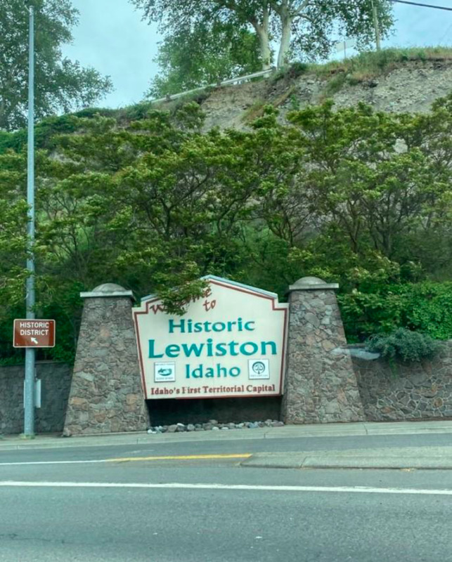
In the end, moving the capitol from Lewiston to southern Idaho left its residents with a sense of lost pride. This sparked a cultural divide between northern and southern Idaho that continues to this day. To this day, downtown Lewiston hosts a sign proclaiming the city “Idaho's First Territorial Capital,” demonstrating that the residents remember their city’s history and will not let people forget Idaho’s original territorial capital.</p><p><em><strong><a href="https://www.intermountainhistories.org/items/show/628">For more (including 3 images) view the original article</a></strong></em></p>]]></summary>
    <published>2022-06-30T20:51:21+00:00</published>
    <updated>2026-04-17T19:32:13+00:00</updated>
    <link rel="alternate" type="text/html" href="https://www.intermountainhistories.org/items/show/628"/>
    <id>https://www.intermountainhistories.org/items/show/628</id>
    <author>
      <name>Dawson Packwood, College of Idaho</name>
    </author>
  </entry>
  <entry>
    <title type="html"><![CDATA[Stibnite Mine: Dormant but Not Dead]]></title>
    <summary type="html"><![CDATA[<p><strong><em>Nestled up in the mountains above Valley County, Idaho, in the Payette National Forest, beyond even the most remote town in the region, and in the middle of an otherwise densely green forest, sits Stibnite the currently dormant Stibnite Mine: a landscape of stripped earth, dead grass, rock, and the infamous “Glory Hole,” an open pit with a sluggish pond of waste. </em></strong></p><img src="https://www.intermountainhistories.org/files/fullsize/20dc0bda7b67c07ecd976075edfdf300.jpg" alt="Glory ole" /><br/><p>The Stibnite Mine, located in what is now the Payette National Forest, started during the 1899 Thunder Mountain gold rush. The first known claims were staked by Albert Hennesy in 1914. Those were later purchased by the United Mercury Mining Company of Boise and optioned by the San Francisco-based Bradley Mining Company in 1927 for mining and milling gold. Stibnite’s most active period of operation came during World War II. A core sample taken from the site revealed an abundance of tungsten and high-grade antimony, materials crucial to the war effort for supplying reinforced armor, ammunition shells, fire resistant clothing, and electrical chips. Between 1941 and 1945, Stibnite miners provided 90% and 40$ of the nation's domestic supply of antimony and tungsten, respectively. 
To extract so much material, Bradley Mining expanded Stibnite into a much larger beast. Instead of digging mine shafts, Bradley initiated open pit mining. To process the raw material, the company installed heavier equipment, such as a smelter and mill. When WWII ended, the demand for antimony and tungsten dwindled, and Stibnite’s profits with it. From this point forward, Stibnite operated off and on throughout the years, passing through different companies several times until it completely shut down in 1997.
The end of active mining didn’t end Stibnite’s story, though; instead, environmental issues took front and center stage. After years of mining, Stibnite had accumulated a massive amount of waste, raising the problem of what to do with it. One major point of contamination came from the Bradley Tailing Pile Dump in the Meadow Creek Floodplain. Preventing massive amounts of mine waste from washing downriver into the valley required diverting Meadow Creek twice. Even after this intervention, an environment and water quality survey conducted periodically from 2011 to 2017 around the Stibnite–Yellow Pine area, which included Meadow Creek, revealed elevated levels of mercury, antimony, and arsenic contamination.
In addition to efforts to minimize the effect of tailings leeching contaminants into the waterways below the site, there have also been efforts to clean up and restore the environmental quality of Stibnite itself. For example, high school students conducted a multi-year tree planting project. Alongside these restoration and monitoring efforts have also been proposals to reevaluate the area’s continued resource potential by Perpetua Resources, the company now in charge of the Stibnite site. As of now, there has been an ongoing bid to reopen the Stibnite area mining once again—gold this time—bringing Stibnite’s mining story up to the present but not necessarily to its end.</p><p><em><strong><a href="https://www.intermountainhistories.org/items/show/625">For more (including 3 images) view the original article</a></strong></em></p>]]></summary>
    <published>2022-06-26T01:59:56+00:00</published>
    <updated>2026-06-16T14:34:55+00:00</updated>
    <link rel="alternate" type="text/html" href="https://www.intermountainhistories.org/items/show/625"/>
    <id>https://www.intermountainhistories.org/items/show/625</id>
    <author>
      <name>Meghan Laughlin, College of Idaho</name>
    </author>
  </entry>
  <entry>
    <title type="html"><![CDATA[Silver Reef, Mining Ghost Town]]></title>
    <summary type="html"><![CDATA[<p><strong><em>After a rare find of silver embedded in a sandstone formation by prospector John Kemple, in the late-1800s, miners rushed to what became Silver Reef, Utah. Silver Reef was one of many towns built around the hopes of finding silver and striking it rich in the West. </em></strong></p><img src="https://www.intermountainhistories.org/files/fullsize/ffa4b5e0508bbc3589041894fe223619.jpg" alt="The streets of Silver Reef" /><br/><p>In the late 1800s, prospectors walked throughout Utah with their noses to the ground, searching for valuable minerals. Utah’s hills and mountains were rich with copper, gold, silver, lead, iron, and zinc just waiting to be discovered.
In 1866, a prospector named John Kemple combed southern Utah in the hopes of finding something that he could mine. While prospecting near what is now Leeds, Utah, Kemple found flakes of silver embedded in sandstone. Such a combination of minerals was an extremely rare discovery; silver was almost never found in sandstone. To prove the veracity of his find, Kemple sent a sample to the Smithsonian Institution, but they called it an “interesting fake.” The silver remained in the ground for nearly a decade until later surveys of the land proved Kemple had told the truth.
In 1875, William T. Barbee, a mining agent for two Salt Lake City bankers, staked several mining claims to the region and established a town called Bonanza City. Many miners and business owners moved to Bonanza City, and property values increased. Several other miners and business owners looking for cheap land set up a tent city north of Bonanza and called it Rockpile. When mines in nearby Pioche closed in 1875, many workers moved to Rockpile. The residents then changed the town’s name to Silver Reef to make it more appealing.
By 1879, about 2,000 people lived in Silver Reef, and the town had a mile-long main street home to many businesses including a cosmopolitan restaurant and a Wells Fargo building. That same year, a fire destroyed many businesses in Silver Reef, including the restaurant and a hotel. Silver Reef’s residents were resilient, and they quickly bounced back and rebuilt. However, as the worldwide value of silver declined during the 1880s, the value of endeavors in Silver Reef declined as well. Most of Silver Reef’s mines closed by 1884, and local businesses followed suit. By 1901, most business owners had either dismantled or relocated their enterprises. After the gradual decline of Silver Reef, the mining operations there traded hands between many large corporations. Eventually, after multiple failed attempts to revive silver mining there, Silver Reef was incorporated into the nearby town of Leeds.
Only a few buildings remain at the old Silver Reef site today. The old Wells Fargo building has been converted into a Silver Reef mining town museum. The cosmopolitan restaurant, dismantled in 1894, was rebuilt in 1987 as a tourist attraction serving European cuisine until it closed in 2010. The Silver Reef Jail remains standing, as well as several building foundations. Latter-day Saints living nearby dismantled other structures in Silver Reef for building materials to construct new buildings.</p><p><em><strong><a href="https://www.intermountainhistories.org/items/show/563">For more (including 4 images) view the original article</a></strong></em></p>]]></summary>
    <published>2021-12-18T08:13:40+00:00</published>
    <updated>2026-04-17T19:32:12+00:00</updated>
    <link rel="alternate" type="text/html" href="https://www.intermountainhistories.org/items/show/563"/>
    <id>https://www.intermountainhistories.org/items/show/563</id>
    <author>
      <name>Lynsie Huff, Brigham Young University</name>
    </author>
  </entry>
  <entry>
    <title type="html"><![CDATA[Eureka! Mining and Settlement in the Tintic Mountains]]></title>
    <summary type="html"><![CDATA[<p><strong><em>Eureka, Utah rests within the East Tintic Mountains in northern Juab county. Established in 1870, within the first twenty years of its existence, the Eureka population increased by 1,320.5%. It was the ninth-largest city in Utah in 1910. Though it was a bustling metropolis in the 1920s, Eureka is now one of Utah’s semi-ghost towns.</em></strong></p><img src="https://www.intermountainhistories.org/files/fullsize/c208bab5d88c9df7c90549eb004d8552.jpg" alt="Abandoned building on main street" /><br/><p><p class="Default"><span style="font-weight:400;">Eureka, Utah is a semi-ghost town located within the East Tintic Mountains in northern Juab County. Originally named Ruby Hollow, the town was renamed “Eureka” in 1870 after one of the “Big Four” mines in the area: Bullion Beck and Champion, Gemini, Centennial Eureka, and Eureka Hill. The largest town among a cluster of mining settlements, by 1910 Eureka was the ninth-largest city in Utah with a population of about 3,500 people. About a decade later, in 1922, Eureka’s Chief Consolidated Mining Company became the largest silver producer in the United States. Around the turn of the 20th century, a newspaper described it as “one of the most progressive and prosperous mining towns in this western country.” Despite its economic prosperity through World War I, the mines near Eureka became less productive during the Great Depression. Mining nearly came to an end by the 1950s. In 2019, the US Census Bureau reported that only about 107 people still lived in Eureka.</span>
<p class="Default"><span style="font-weight:400;">Eureka has connections with several illustrious figures in Utah’s history. Eureka was home to the second “Golden Rule” store built in 1909 by James Cash Penney. Expanding his business from this location, Penney developed the J.C. Penney chain of department stores. Jesse Knight, known for financially contributing to Brigham Young University where a campus building bears his name, also has ties to Eureka. Knight invested in the Humbug mine in 1886, and using the profits of his investment, Knight acquired several additional mines in the Tintic Mountains. He built a company town near Eureka called Knightsville, where he built a meetinghouse, school, and amusement building, though the settlement has since become a ghost town. Eureka is also the birthplace of Frank J. Zamboni, the inventor of the Zamboni, a vehicle used to clean and resurface the ice in ice rinks. A building which locals say was the original summer cabin of Porter Rockwell is also found along Eureka’s Main street. Eureka celebrates this history with a western diner named Porter’s Place.</span>
<p class="Default"><span style="font-weight:400;">Although people still live in Eureka, residents maintain its historic, mining town feel. In 1979, Eureka was added to the National Register of Historic Places, and several place markers provide insight into the town’s history. Main Street is full of historic, repurposed, or abandoned buildings. For example, the post office built in 1894 was purchased by the “Everybody’s” merchandising company in 1926. It currently serves as a shop today with products and souvenirs linked to Eureka’s rich history. Multiple historic churches are scattered along Eureka’s Main Street, most built in the Gothic Revival Style. The former Miner’s Union Hall has been repurposed as the Tintic Mining Museum. Some buildings, however, retain their original purposes, such as the Juab County Courthouse which still serves as the County Courthouse and City Jail.</span>
<p class="Default"><span style="font-weight:400;">Eureka is picturesque both in its architecture and in its surrounding landscape. It is a fitting home base for anyone looking to learn about Utah’s mining history, explore its nearby ghost towns such as Knightsville, Homansville, Dividend, or Silver City, or enjoy some of the outdoor scenic wonders that Juab County has to offer.</span></p><p><em><strong><a href="https://www.intermountainhistories.org/items/show/559">For more (including 4 images) view the original article</a></strong></em></p>]]></summary>
    <published>2021-12-18T04:17:31+00:00</published>
    <updated>2026-04-17T19:32:12+00:00</updated>
    <link rel="alternate" type="text/html" href="https://www.intermountainhistories.org/items/show/559"/>
    <id>https://www.intermountainhistories.org/items/show/559</id>
    <author>
      <name>Emily Sabey, Brigham Young University</name>
    </author>
  </entry>
  <entry>
    <title type="html"><![CDATA[Sunshine Mine Disaster]]></title>
    <summary type="html"><![CDATA[<p><strong><em>On May 2, 1972, the Sunshine Mine experienced a devastating fire. Claiming the lives of seventy-one men, the Sunshine Mine Disaster is considered one of the worst mining disasters in Idaho’s history.</em></strong></p><img src="https://www.intermountainhistories.org/files/fullsize/a74eff8e5bddf88d0b3807cc81cc5f79.jpg" alt="Sunshine Miners Memorial" /><br/><p>The fire at the Sunshine Mine, a silver mine near Kellogg, Idaho, was first reported at about 11:40 pm after an electrician smelled smoke and warned the foreman. The foreman telephoned down to the mechanics, who were in a work room, and asked them to see where the fire was burning. When they decided to head to another tunnel to search, they found it so filled with smoke they could not enter; when they moved toward an adjacent tunnel, they found it was also filled with smoke. Simultaneously, the shaft foremen requested had the warning system activated, alerting miners to the presence of gas, and sent oxygen masks into the mine. Most of the men became aware of the fire when the smoke entered their workplaces, which they retreated from by moving toward another part of the shaft. There, miners hoisted men up to the surface. This continued until about 1:00 PM when the miner manning the lift was overcome by gas and smoke. Men on the lower levels were stuck, and while many tried to make it to where men were being hoisted to the surface or at least barricade themselves against the gas, most died from carbon monoxide exposure.
While the surviving miners and surface workers mounted their own rescues, they also called in trained rescue teams. In order to reach the bottom of the mine, rescuers and workers needed to use mine hoists to travel up and down the shafts, and that required repairing the electical system. However, with so much gas and smoke, the crew could work only for as long as their oxygen tanks lasted, about two hours at a time. With so little time, rescuers chose to focus on finding survivors rather than removing the bodies, and they forced themselves to walk past and over the bodies of asphyxiated miners every time they made the trip to the repair site. In total, eighty escaped the mine, only two survived the disaster while inside the mine, and ninety-one died.
The exact reason and location for the fire is unknown. Because the fire damaged walls and support beams, the mine partially collapsed, burying areas that might have provided clues. The Sunshine Mine’s high profile fire significantly impacted discourse surrounding the safety of hard rock mining. This disaster prompted Congress to pass the Federal Mine Safety and Health Act of 1977, improving safety standards for hard rock mining. For example, the act required mines to provide more ventilation and to create plans for guiding surface workers’ response in the event of another disaster. The act also stipulated mandatory disaster training so all miners knew what to do and where to go in an emergency, and it required miners have personal oxygen tanks with them at all times. Overall, the act created a safer work environment to help prevent similar disasters in the future.</p><p><em><strong><a href="https://www.intermountainhistories.org/items/show/539">For more (including 4 images) view the original article</a></strong></em></p>]]></summary>
    <published>2021-11-13T22:39:10+00:00</published>
    <updated>2026-04-17T19:32:11+00:00</updated>
    <link rel="alternate" type="text/html" href="https://www.intermountainhistories.org/items/show/539"/>
    <id>https://www.intermountainhistories.org/items/show/539</id>
    <author>
      <name>Megan Wagner, Northern Arizona University</name>
    </author>
  </entry>
  <entry>
    <title type="html"><![CDATA[Castle Gate Mine Disaster]]></title>
    <summary type="html"><![CDATA[<p><strong><em>The Castle Gate Mine Disaster was a horrific tragedy that took the lives of 171 men. Considered the second-worst mining disaster in Utah’s history, the disaster is well remembered not only for the death toll but also for the push for safety reform in its aftermath.</em></strong></p><img src="https://www.intermountainhistories.org/files/fullsize/3addcc19e4ca5cf2966b852500df227f.jpg" alt="Mass funeral" /><br/><p>On March 8, 1924, in Castle Gate, Utah, two explosions rocked the local coal mine, killing all 171 men working at the time. Both explosions happened when men ignited carbon monoxide while trying to relight their lamps. First, a boss investigating some methane gas near the roof of a mineshaft. When his lamp went out, he tried to relight it, but his match ignited the gas, which in turn ignited coal dust, setting off a huge explosion. Those who survived this first explosion found themselves plunged into darkness, as the blast blew out their lamps. When these survivors attempted relighting their lamps, they set off another explosion.
Rescue workers faced severe challenges when they entered the mine to look for any possible survivors. The passageway was covered with debris and badly damaged. It made the passageway incredibly difficult to traverse and slowed them down. The mine was also filled with gas, which made it deadly for the rescue workers. One rescuer died when another knocked off his oxygen clip; within a few minutes, he breathed in too much gas and perished. When the workers found the bodies, many were badly burned and mutilated. Because of huge number of deaths, bodies were buried soon after identification.
Most of the men were married with children, leaving behind many widows and children without fathers. In the days after the disaster, the Red Cross along with women from other parts of came to offer aid to the families. They cooked meals, tended to children, and even sewed mourning clothes for the community. The families of the miners were devastated; in addition to losing a husband and father, they also lost their primary financial provider. Although the families did receive compensation, many left Castle Gate to go live with relatives. Those who stayed received aid from a Red Cross committee that provided food, clothes, and anything else the families might need. The relief committee continued to distribute aid until 1936, ultimately dispersing $132,145 worth of relief.
The mine eventually reopened with increased safety measures. The Utah Fuel Company, which owned the mine, met with the state government to review safety laws and create new amendments and resolutions to make the mines safer. This included more funding for mine inspectors, mandates about clearing dust created from rock mining, prohibiting moving methane gas while men were working in the mine, and requiring coal dust be cleaned from abandoned rooms. Though these new procedures did not completely stop other disasters, they did greatly improve the safety of the mines.</p><p><em><strong><a href="https://www.intermountainhistories.org/items/show/538">For more (including 3 images) view the original article</a></strong></em></p>]]></summary>
    <published>2021-11-13T22:04:12+00:00</published>
    <updated>2026-04-17T19:32:11+00:00</updated>
    <link rel="alternate" type="text/html" href="https://www.intermountainhistories.org/items/show/538"/>
    <id>https://www.intermountainhistories.org/items/show/538</id>
    <author>
      <name>Megan Wagner, Northern Arizona University</name>
    </author>
  </entry>
  <entry>
    <title type="html"><![CDATA[White Ash Mine Disaster]]></title>
    <summary type="html"><![CDATA[<p><strong><em>A flood in the White Ash Mine, located in Colorado, killed ten men. Though not the worst mining disaster in Colorado history, the White Ash Mine disaster is remembered for a mysterious fire that thwarted an attempt to rescue the drowned miners.</em></strong></p><img src="https://www.intermountainhistories.org/files/fullsize/319b9bf4fa97e5419ff9cdd0e0e32404.jpg" alt="The mine and her miners" /><br/><p>On September 9, 1889, at about four o’clock in the afternoon ten men drowned in the White Ash Mine, a coal mine near Golden, Colorado. An engineer, Charles Hoagland, was the first to discover that something had happened. He had attempted to send down the elevator, but it wouldn’t go to the bottom, and then it wouldn’t rise. Hoagland attempted to contact the cage man who was at the bottom of the mine, but he did not respond. Hoagland phoned the foreman, Evan Jones. When Jones descended into the mine, he heard the roaring of water. Realizing the mine was flooding, he informed the general manager and gathered other men in an attempt to rescue the men trapped below. However, they were only able to travel about 300 feet down before they were hit with bad air and retreated. Around midnight, the mine inspector, John McNeil, and the general manager, Paul Lanious, descended into the mine.
They found out the mine, which was about 780 feet deep, was filled with CO2. The water had reached 140 feet high and was scalding hot at about 115 degrees Fahrenheit. At about 280 feet down, they felt a strong heat coming out of the walls; when they examined the area, they found that a portion of this level was on fire. The fire was getting closer to the shaft timbers, making it impossible to isolate the fire and put it out. McNeil and Lanious made it about 400 feet down before the gas became too much, forcing them to ascend.
As a result of the fire, the gas, and the height of the water, officials concluded the men could not have survived. With the mine considered too dangerous, officials suspended extraction efforts and instead sealed off the shaft. Their decision entombed the men in the mine.
In the aftermath, people wondered that had caused the disaster. Investigation revealed the most likely culprit was the Loveland Mine, attached to the White Ash Mine through coal veins. About ten years before the White Ash Mine flood and fire, the Loveland Mine had itself shut down due to flooding. Over the years, the underground
The biggest question that everyone had was what caused the disaster. The culprit was found to be the Loveland Mine which was attached to the White Ash Mine through coal veins. The Loveland Mine had been closed about ten years before the disaster on account of flooding. While White Ash passed inspections, showing no signs of potential flooding, over the years the coal walls separating Loveland and White Ash degraded. When they finally broke down, the floodwaters still inside Loveland poured into White Ash.
While the precise reasons the coals walls degraded is not known for certain, most people believe an underground fire had smoldered inside Loveland and slowly ate away at the coal separating the two mines. In fact, McNeil had discovered a smoldering fire between the walls a few years earlier, though he had it sealed up. However, there may have been a second fire that went unnoticed. This unchecked fire made the walls crumble, allowing the Loveland Mine’s water to drain into the White Ash.</p><p><em><strong><a href="https://www.intermountainhistories.org/items/show/537">For more (including 4 images) view the original article</a></strong></em></p>]]></summary>
    <published>2021-11-13T21:37:47+00:00</published>
    <updated>2026-04-17T19:32:11+00:00</updated>
    <link rel="alternate" type="text/html" href="https://www.intermountainhistories.org/items/show/537"/>
    <id>https://www.intermountainhistories.org/items/show/537</id>
    <author>
      <name>Megan Wagner, Northern Arizona University</name>
    </author>
  </entry>
</feed>