<?xml version="1.0" encoding="UTF-8"?>
<feed xmlns="http://www.w3.org/2005/Atom">
  <title type="text">Intermountain Histories</title>
  <updated>2026-04-17T19:32:20+00:00</updated>
  <generator uri="http://framework.zend.com" version="1.12.20">Zend_Feed_Writer</generator>
  <link rel="alternate" type="text/html" href="https://www.intermountainhistories.org/"/>
  <link rel="self" type="application/atom+xml" href="https://www.intermountainhistories.org/items/browse?output=rss2"/>
  <id>https://www.intermountainhistories.org/</id>
  <author>
    <name>Intermountain Histories</name>
    <uri>https://www.intermountainhistories.org</uri>
  </author>
  <link rel="hub" href="https://pubsubhubbub.appspot.com/"/>
  <entry>
    <title type="html"><![CDATA[United States Air Force Academy Chapel, Colorado Springs, CO]]></title>
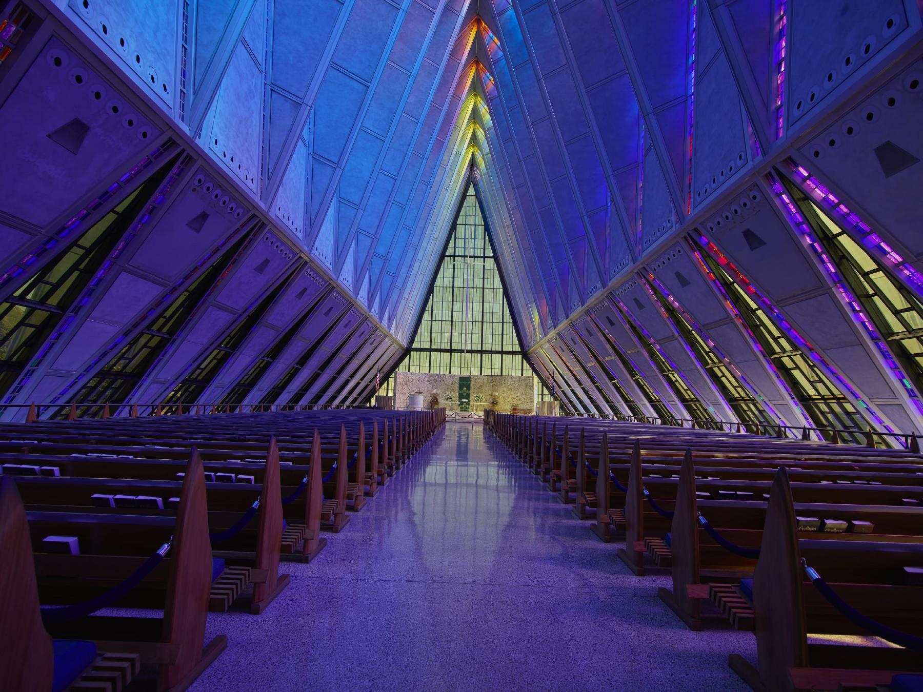
    <summary type="html"><![CDATA[<p><strong><em>An architectural triumph, the United States Air Force Academy Chapel in Colorado Springs is a futuristic vision of spirituality and light.</em></strong></p><img src="https://www.intermountainhistories.org/files/fullsize/6fa877fa8a8572d3d403698d65fbe97e.jpg" alt="Interior of the main atrium in the Cadet Chapel" /><br/><p>     Outside of Colorado Springs on the front Rampart Range of the Rocky Mountains the soaring spires of the United States Air Force Academy Chapel stand as a shining example of modernist architecture. Composed of seventeen spires that rise 150 feet into the air, the profile of the chapel mimics the mountains behind it. Each individual spire is is made up of 100 polygon shapes with the crisp edges giving the chapel a strikingly futuristic feel. The main floor houses the nine-hundred seat Protestant service area directly underneath the striking spires. Between the spires are one-foot-wide panels of colored glass, arrayed with cubes of every color of the rainbow. The panels bounce light off the faceted interior of the chapel during the day as the sun streams in. At night, interior illumination sends their color pouring over the outside of the aluminum spires, highlighting the materials reflective qualities. Underneath the main level is the area devoted to holding Catholic services. This level is demarcated by low sweeping stonework and large mosaic of stone angels behind the altar. Also on the terrace level is the Jewish service section. A circular screen of Israeli cypress panels ensconces the prayer area and the floor is made of Jerusalem Brownstone tiling donated by the Israeli Defense force in 1960.
     It was these three faiths that architect Walter Netsch was tasked with designing the building around in 1954 when the firm Skidmore Owings & Merrill received the contract to design the Air Force Academy Campus. The rest of the campus is made up of lower profile, modernist structures that seem to hover above the earth. The Cadet Chapel has remained the crown gem of the campus since its completion in 1962.
     The sub-genre of googie architecture experienced peak popularity in the mid-century and left its largest marks upon commercial structures in the West. Diners and motels are the most common manifestations of this style. However, while many googie structures are commercial that is not a requirement for the classification. Perhaps the most important aspect of googie architecture is that the structures appear to exist out of time. Materials like aluminum, neon, and concrete are utilized to give the buildings a futuristic and industrial touch, as if they were designed in the 22<sup>nd</sup> century instead of the 21<sup>st.</sup>. The Cadet Chapel epitomizes the idealistic futurism of the googie genre, brought out of the realm of the commercial and into the spiritual.
     In 2019 renovations began with the initial goal of fixing water leakage problems that had been persistent since the building was completed. Restoration has been ongoing due to the delicate nature of the historic structure and is projected to be completed in 2027. In 2012, fifty years after the completion of the Cadet Chapel, SOM returned to the campus to create a new event center called Polaris Hall. The glass prism tower of Polaris Hall is a testament to the lasting appeal of strikingly modernist architecture like that of the Cadet Chapel that inspired it.</p><p><em><strong><a href="https://www.intermountainhistories.org/items/show/901">For more (including 3 images) view the original article</a></strong></em></p>]]></summary>
    <published>2025-09-23T15:36:00+00:00</published>
    <updated>2026-04-17T19:32:20+00:00</updated>
    <link rel="alternate" type="text/html" href="https://www.intermountainhistories.org/items/show/901"/>
    <id>https://www.intermountainhistories.org/items/show/901</id>
    <author>
      <name>Emily MacDonell, Northern Arizona University</name>
    </author>
  </entry>
  <entry>
    <title type="html"><![CDATA[The Battle of Glorieta Pass and the Confederate Campaign in New Mexico]]></title>
    <summary type="html"><![CDATA[<p><strong><em><span style="font-weight:400;">The Battle of Glorieta Pass marked a pivotal moment in the American Civil War's Western Theater. Often called the "Gettysburg of the West," this 1862 clash determined the fate of Confederate ambitions as they attempted to expand into New Mexico and beyond.</span></em></strong></p><img src="https://www.intermountainhistories.org/files/fullsize/a7fa00d8af44b7b6e3f361212c0c14d3.jpg" alt="Battle of Glorieta Pass at Pigeon&#039;s Ranch by Roy Andersen" /><br/><p><span style="font-weight:400;">In March 1862, the Battle of Glorieta Pass emerged as a pivotal moment in the Civil War as Confederate troops attempted to seize control of New Mexico, a territory long coveted by the South for its mineral wealth and strategic position along important routes of trade. After capturing Santa Fe on March 13, Brigadier General Henry Hopkins Sibley and his Confederate forces sought to consolidate their gains by advancing toward Fort Union, the last major Union stronghold in the New Mexico territory. However, their path was obstructed by the determined forces of Colonel John Slough, who were preparing to mount a counteroffensive against Sibley’s attack.</span>
<span style="font-weight:400;">Slough's division, bolstered by 800 Colorado volunteers, began their march from Fort Union to engage Sibley’s troops. The Union strategy hinged on thwarting the Confederate advance and securing vital supply lines. As the two armies maneuvered toward each other, they both sought to control the strategic high ground at Glorieta Pass.</span>
<span style="font-weight:400;">On March 28, the two sides met in Apache Canyon, with skirmishes erupting as the Confederate forces attempted to strike the enemy first. Initially caught off guard, the Confederates regrouped and engaged the Union troops ferociously. The fighting soon escalated, with the Union holding the high ground and utilizing artillery to devastating effect against Confederate assaults. Despite this advantage, Colonel Sam Shropshire was killed, a critical blow to the Union’s command. As the battle raged, the Confederate forces made a series of bold charges in an attempt to break through Union lines. They managed to push the Federals back, but their success was tempered by heavy casualties. By the afternoon, Sibley’s forces found themselves at a critical juncture. Their position had begun to erode under the relentless fire of Union artillery, which had effectively neutralized many of their advances.</span>
<span style="font-weight:400;">In a dramatic turn of events, the Confederate forces received alarming news from their base of operations at Johnson’s Ranch. A Union column, led by Captain John Chivington, had launched a surprise attack on the Confederate supply camp, destroying vital resources and inflicting further damage. With eighty supply wagons burned and many pack animals lost the Confederates faced a tenuous situation, exacerbated by their own diminishing supplies. Recognizing the untenable nature of their position at Glorieta Pass, Sibley ordered a retreat to Santa Fe to regroup. Meanwhile, Colonel Slough seized the opportunity to coordinate a follow-up attack, intent on pushing the Confederates further back. The Union forces, now reinvigorated, were ready to capitalize on their opponent’s misfortunes. By March 29th, it was clear to the Confederate commanders that the battle had not yielded the decisive victory they had sought. Retreating to Santa Fe, Sibley hoped to reestablish communication with the Texas government for reinforcements. However, dwindling supplies hampered their efforts, leading to a chaotic withdrawal from the region as they attempted to escape the approaching Union forces. </span>
<span style="font-weight:400;">The Battle of Glorieta Pass marked a turning point in the New Mexico Campaign, symbolizing the failure of Confederate ambitions in the Southwest. Although both sides incurred significant losses—432 Union casualties and 187 Confederate—the aftermath proved disastrous for Sibley’s forces, setting the stage for further Union advances in the territory. The battle ultimately underscored the Confederacy's vulnerability, dashing their hopes of establishing a stronghold in the West, and left them to retreat back to Texas with little more than the remnants of their once-promising campaign.</span></p><p><em><strong><a href="https://www.intermountainhistories.org/items/show/878">For more (including 3 images) view the original article</a></strong></em></p>]]></summary>
    <published>2025-01-27T01:49:52+00:00</published>
    <updated>2026-04-17T19:32:20+00:00</updated>
    <link rel="alternate" type="text/html" href="https://www.intermountainhistories.org/items/show/878"/>
    <id>https://www.intermountainhistories.org/items/show/878</id>
    <author>
      <name>Benjamin Nichols, Brigham Young University</name>
    </author>
  </entry>
  <entry>
    <title type="html"><![CDATA[The Plane of the People]]></title>
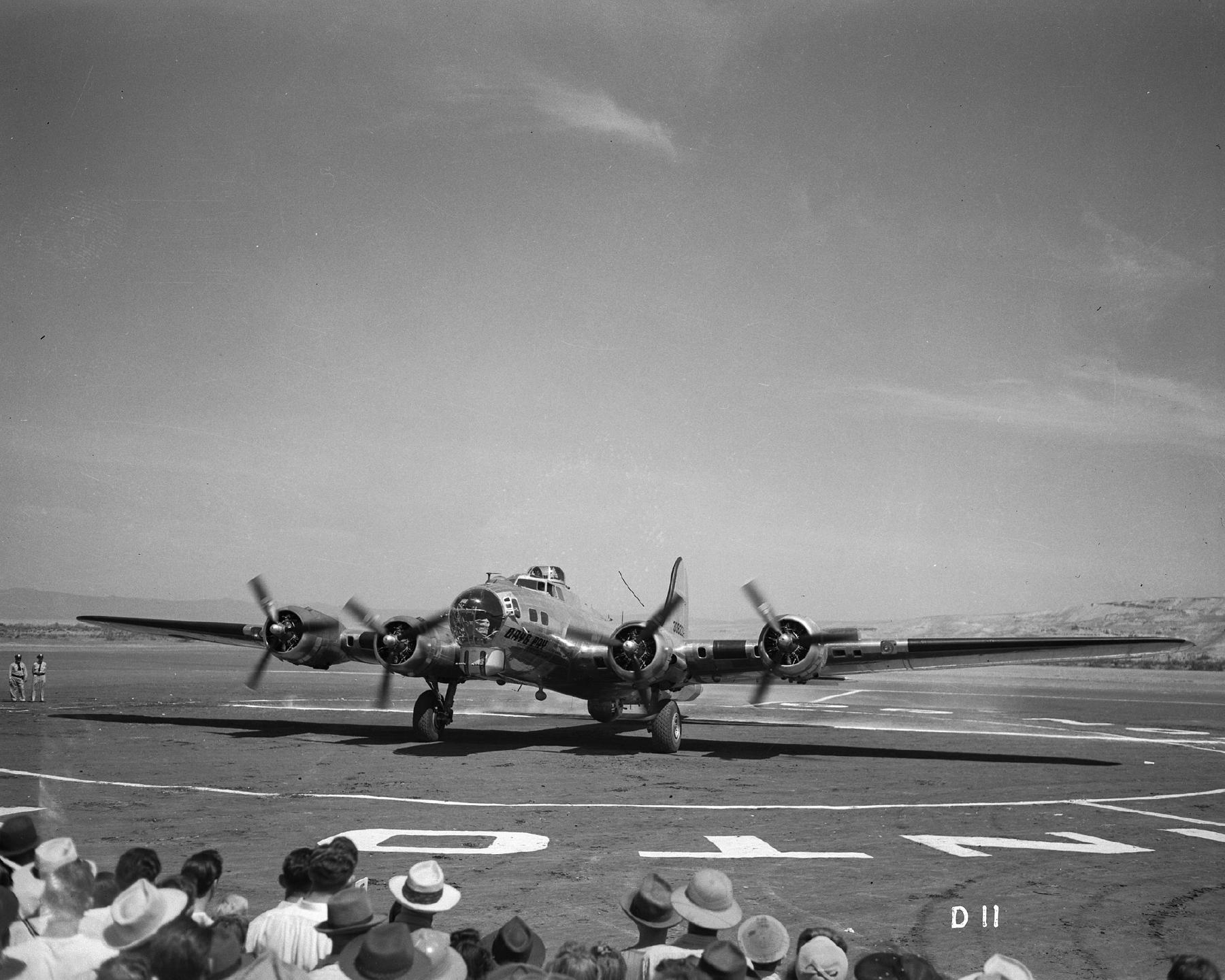
    <summary type="html"><![CDATA[<p><strong><em>During World War II the people of the Hanford Site came together to buy a bomber to support the war effort. The “Give a Bomber” campaign created a legacy that continues to bind a town together.</em></strong></p><img src="https://www.intermountainhistories.org/files/fullsize/5cc1c2fd94c0b5b7485b37b7f3d037e9.jpg" alt="The Day’s Pay B-17 Bomber at the celebration" /><br/><p><span style="font-weight:400;">Would you give up a day's pay to help your country? The workers of Hanford, Washington, where the plutonium was made for the Manhattan Project, decided to contribute their wages to buy a bomber to send overseas. Demonstrating their enthusiasm, 51,000 employees gave up a day’s pay for a certificate acknowledging their “share” of the bomber. The campaign’s slogan “Give a day’s pay and send a bomber on its way,” influenced the name of the plane as “Days Pay” was the overwhelming winner when the “Give a Bomber” committee held a contest to pick a name for th</span><span style="font-weight:400;">e plane. The workers asked the Army Air Force what type of plane it needed. The answer came back asking for the B-17 Flying Fortress, with the cost of the bomber being approximately $300,000 in 1944 (costing $5,257,107.95 in 2024).</span>
<span style="font-weight:400;">On July 23, 1944, workers christened the new plane and dedicated it to Colonel David Wade, along with Mrs. Katie Belle Harris, whose son had been lost in action. The Day’s Pay then became a part of the 8th Army Air Force in England, where it flew more than 60 missions in Germany. The plane was hit to the point of critical condition multiple times, but, what was very rare for the time was that every man on that bomber returned home safely and unharmed, which made the Day’s Pay a lucky plane.</span>
<span style="font-weight:400;">The employees who bought Day’s Pay continued to keep track of it as it flew missions, with the employee newspaper, the </span><i><span style="font-weight:400;">Sage Sentinel,</span></i><span style="font-weight:400;"> reporting on its mission progress. The paper also published a list of the plane’s crew, which allowed the employees to send Christmas cards and care packages to “their” boys overseas as well as check in on “our” plane. Unfortunately after the war, on December 4, 1947, it was taken to Kingman Field, Arizona, and reduced to scrap. </span>
<span style="font-weight:400;">But the legacy of the Day’s Pay lives on in the Richland police department’s badge, the name of a local microbrewery, and other businesses. The largest showing of the Day’s Pay comes from Richland High School, where a mural of the Day’s Pay covers one side of the gymnasium and the football team wears a simplified B-17 bomber sticker on the backs of their helmets. The Richland High School class of 2021 raised money to have a B-17 bomber fly over for graduation, demonstrating that the Day’s Pay is alive and instills community pride to this day.</span></p><p><em><strong><a href="https://www.intermountainhistories.org/items/show/870">For more (including 5 images) view the original article</a></strong></em></p>]]></summary>
    <published>2024-10-22T21:07:24+00:00</published>
    <updated>2026-04-17T19:32:19+00:00</updated>
    <link rel="alternate" type="text/html" href="https://www.intermountainhistories.org/items/show/870"/>
    <id>https://www.intermountainhistories.org/items/show/870</id>
    <author>
      <name>Mason Williamson, Rocky Mountain College</name>
    </author>
  </entry>
  <entry>
    <title type="html"><![CDATA[The Nephi Massacre during Wakara’s War<br />
]]></title>
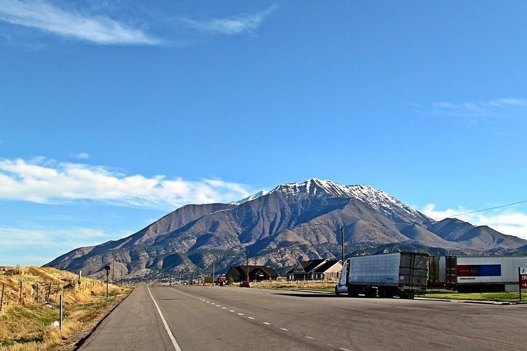
    <summary type="html"><![CDATA[<p><strong><em>During Wakara’s War in 1853-54 a group of Utes killed four Mormons at Fountain Green.  The next day, Mormons killed eight Utes or Goshutes seeking peace with LDS settlers in Nephi, Utah. The discovery of their remains in Nephi’s Old Hallow in 2006 highlighted the brutality of Wakara’s War, a series of conflicts during 1853 between settlers and Indigenous residents in central Utah Territory.</em></strong></p><img src="https://www.intermountainhistories.org/files/fullsize/fafd241883d271d8b9793e3097ca8da1.jpg" alt="Nephi, Utah" /><br/><p>In 2006, an archaeological discovery in Nephi, Utah, shed light on a tragic event that occurred in 1853 during the Walker War, also known as the Wakara War. The excavation revealed a mass grave containing the remains of seven Goshutes, including a young boy. The bodies were found piled on top of each other. Forensic analysis discovered gunshot wounds, shattered bones, and evidence of blunt force trauma.</p><p>The Wakara War between settlers and Utes was infuriated by the encroachment of additional LDS settlements in Utah and Sanpete counties in Utah Territory. The incident in Nephi occurred on October 2, 1853, when a group of Utes or Goshutes came to the fort. The account reported in the Deseret News portrayed the Natives as aggressors in a tussle they initiated with the militia. Recent research, including the discovery of journals of witnesses Adelia Wilcox and Martha Spence Heywood, however, contradict this narrative.</p><p>The forensic evidence from the mass grave suggests that the Native men, ranging in ages from 16 to 25, were not killed in a skirmish but were executed. Gunshot wounds in the back of the head and traumatic injuries indicate a cold-blooded killing, challenging the original historical account. The discovery of the mass grave by construction workers laying a foundation for a home in 2006 provided an opportunity to combine scientific discovery, archaeology and forensic analysis, and historical records to correct and update the historical narrative and include the perspectives of those killed. The story of the Nephi mass grave is a significant reminder of the complexities surrounding historical narratives and how archaeological revelations can amend those stories.</p><p><em><strong><a href="https://www.intermountainhistories.org/items/show/856">For more (including 3 images) view the original article</a></strong></em></p>]]></summary>
    <published>2024-09-25T15:00:26+00:00</published>
    <updated>2026-04-17T19:32:19+00:00</updated>
    <link rel="alternate" type="text/html" href="https://www.intermountainhistories.org/items/show/856"/>
    <id>https://www.intermountainhistories.org/items/show/856</id>
    <author>
      <name>Chelsea Woodruff, Brigham Young University</name>
    </author>
  </entry>
  <entry>
    <title type="html"><![CDATA[Geronimo Surrender Monument]]></title>
    <summary type="html"><![CDATA[<p><strong><em>For many years, the ferocity and war tactics of the Chiricahua Apaches deterred the American military from taking their land in Arizona. General William T. Sherman became so frustrated by the Apache that he suggested Arizona should be abandoned to the American Indians. Despite these resilient efforts in maintaining their land, the Chiricahua surrendered to preserve their people from a “bitter end.” The Geronimo Surrender Monument stands as a stark reminder in Skeleton Canyon of southern Arizona. </em></strong></p><img src="https://www.intermountainhistories.org/files/fullsize/ab99b990d9a8de68c67dae2ffd6fa20b.jpg" alt="Apache Gaan dancers " /><br/><p>The Chiricahua Apaches settled in southeastern Arizona, southwestern New Mexico, and northern Mexico in the Sonoran and Chihuahuan Deserts. They fielded fierce warriors with agile, athletic builds that proved a formidable fighting force in the desert Southwest. Apaches constructed easily built dome-shaped wickiup dwellings made of thatch and poles and covered with animal skins.</p><p>Few Americans entered Chiricahua territory before the gold rush. The 1851 discovery of gold in the Pinos Altos region of New Mexico, which lay at the Southern end of the Black Mountains, homeland of the Warm Springs Band of Chiricahua, was an early source of conflict. Apaches did not understand the allure of this metal to Americans. The endeavor to mine for gold was purposeless and sacrilegious to their nation. Nonetheless, miners were determined to invade their territory and take its resources and the Chiricahua successfully resisted those efforts for several decades. The federal government attempted to create peace through several treaties, but both sides had difficulty adhering to the terms.</p><p>Many battles ensued between the Chiricahua, settlers, and American troops. While the Americans had better developed equipment and weapons, the Apache knew the land better and had more experience fighting to defend their homeland. They evaded and defeated military forces hundreds of times their size. Despite their best efforts to protect their sovereignty, the Chiricahuas knew they could not continue to thwart the efforts of the American militia indefinitely. The Apache wars brought great hardships to their people, so Apache leaders Geronimo and Nachiz, met with Lieutenant Gatewood to discuss the future of their people. The Lieutenant explained that if they surrendered, their families would be sent to Florida to await the final decision of the President. If they did not surrender, they would have to fight to the bitter end. After some discussion, Nachiz and Geronimo decided to surrender in order to preserve their people. Despite many years of successfully resisting American encroachment, the Chiricahua Apaches capitulated to the government’s demands in Skeleton Canyon on September 4, 1886, a location now known as the Last Stand of the Chiricahua Apaches. The Chiricahua Apaches were evicted from their ancestral homeland, temporarily assigned to Florida and Alabama, before being the last Indigenous nation the U.S. Congress relocated into present-day Oklahoma in 1894.</p><p><em><strong><a href="https://www.intermountainhistories.org/items/show/848">For more (including 4 images) view the original article</a></strong></em></p>]]></summary>
    <published>2024-09-24T04:49:59+00:00</published>
    <updated>2026-04-17T19:32:19+00:00</updated>
    <link rel="alternate" type="text/html" href="https://www.intermountainhistories.org/items/show/848"/>
    <id>https://www.intermountainhistories.org/items/show/848</id>
    <author>
      <name>Leah T. Smith, Brigham Young University</name>
    </author>
  </entry>
  <entry>
    <title type="html"><![CDATA[The 509th Composite Group at Wendover Air Force Base<br />
]]></title>
    <summary type="html"><![CDATA[<p><strong><em>In the words of historian Roger D. Launius, “America in the early 1940s was a nation on the move as never before. The exigencies of war reoriented virtually every aspect of the culture, economy, demographics, and politics of aviation in the United States.” The 509th Composite Group at Wendover Air Force Base played an integral role in this transformation by training new pilots, testing new aviation technologies, and successfully executing the Manhattan Project, bringing an end to the bloodiest war the world has ever seen.</em></strong></p><img src="https://www.intermountainhistories.org/files/fullsize/670f71176dece6eb09d290a00396650a.jpg" alt="[Untitled]" /><br/><p><span style="font-weight:400;">One of Utah’s most significant contributions to the American effort during WWII was the creation and training of the 509th Composite Group, “the only unit ever to drop an atomic bomb in combat.” Originally the 393rd Bombardment Squadron, the 509th was created by General Henry “Hap” Arnold, who selected Lt. Colonel Paul W. Tibbets to head the group. Lt. Col Tibbets was given the options of Mountain Home, ID; Fairmont, NE; and Wendover, UT to host his group, as “all three had acceptable facilities and runways for B-29 operations.” Lt. Col Tibbets ultimately chose the site in Utah based on its extensive bombing and gunnery range facilities, as well as the history of heavy bomber training in Utah. The required facilities were already in place in Wendover. The Utah site was also desirable because of its relative proximity to Los Alamos, NM; the site responsible for developing the nuclear payload Tibbets’ team would be delivering. Additionally, since Wendover was so isolated, the project could be kept secret from prying eyes, both foreign and domestic.  </span>
<span style="font-weight:400;">The 509th Composite Group trained from 1944-1945, dropping 5,000 to 10,000 pound dummy bombs, conducting rapid turns to avoid the nuclear blowback (though the crews weren’t told the reason for these maneuvers), and increasing accuracy to within 200 meters of their targets. On May 29, 1945 the group was relocated to Tinian in the Mariana Island chain. Afew months later they dropped two atomic bombs on Japan, effectively ending the world’s largest and bloodiest conflict. From the “History of the 509th Composite Group” written in 1945, there was an interview with Lt. Colonel Tibbets where he was asked about the success and contributions of the 509th Composite Group. When asked whether the group “measured up to expectations” regarding its contributions and fulfillment of the Manhattan Project, Lt. Colonel Tibbets replied:  </span>
<span style="font-weight:400;">The mission of the 509th was accomplished. Its success is now a matter of world history. In all probability this success surpasses the expectations of those intimately connected with the early phases of the project. It is safe to say that the 509th never held up the work of the project. Many times the 509th caused the project to speed up their efforts because the unit shaped up faster than expected and was committed to the theater ahead of schedule. The success of this organization is due to teamwork by all people in the outfit and the willingness with which they cooperated with the project people to accomplish our assigned mission.</span>
<span style="font-weight:400;">Following the successful conclusion of World War II, thanks in large part to the efforts of the 509th Composite Group, Wendover Air Force Base continued to train new generations of pilots, develop new technologies, and build the fledgling Army Air Corps into the most dominant Air Force the world has ever seen.  </span></p><p><em><strong><a href="https://www.intermountainhistories.org/items/show/794">For more (including 4 images) view the original article</a></strong></em></p>]]></summary>
    <published>2024-03-19T01:53:40+00:00</published>
    <updated>2026-04-17T19:32:17+00:00</updated>
    <link rel="alternate" type="text/html" href="https://www.intermountainhistories.org/items/show/794"/>
    <id>https://www.intermountainhistories.org/items/show/794</id>
    <author>
      <name>Joshua W. Sturgill, Brigham Young University</name>
    </author>
  </entry>
  <entry>
    <title type="html"><![CDATA[Jewish Contribution to the Manhattan Project ]]></title>
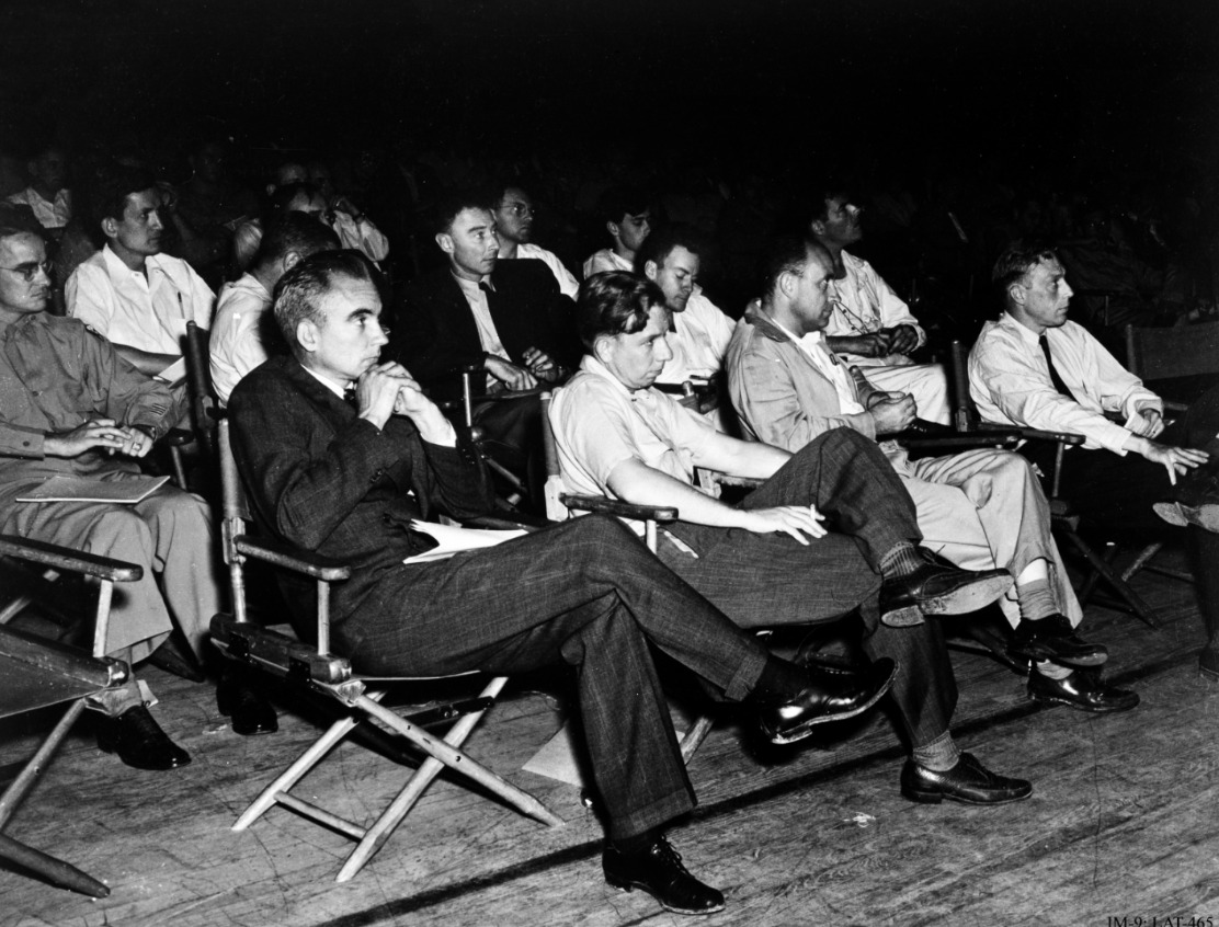
    <summary type="html"><![CDATA[<p><strong><em>Jewish participation in the Manhattan Project, particularly in Los Alamos, was an essential part of the operation's success. They continued to support their country despite local discrimination and the tragedy of World War II occurring abroad. </em></strong></p><img src="https://www.intermountainhistories.org/files/fullsize/89d79d7a997cf1681e9e7681568b097e.jpg" alt="Manhattan Project Scientists" /><br/><p>The United States’ development of the first atomic bomb would not have been possible without the contribution of Jewish Americans and Jewish refugees who fled Nazi Germany and war-torn Europe throughout the Manhattan Project. In August of 1939, Albert Einstein, Leo Szilard, and Enrico Fermi drafted and sent a letter to President Roosevelt via Alexander Sachs, warning the President of the potential use of atomic power in weaponry. This, in addition to another letter sent by British-Jewish scientists, led Roosevelt to form an advisory committee on uranium and, eventually, create the Manhattan Project.</p><p>Significantly, every person involved in the drafting and deliverance of this letter were Jewish or had close Jewish family members. Of the four involved, three were European refugees. Einstein was from a family of German Ashkenazi Jews and fled to the United States in 1933. Szilard was from a Hungarian Jewish family and fled to England in 1933 and then the United States in 1938. Fermi, while himself not Jewish nor German, was married to a Jewish woman which required him and his family to flee his home of Italy in 1938. Sachs was American-Jewish and an important advisor to President Roosevelt. All were impacted by the anti-Semitism of Germany and were respected and prominent enough to sway the President of the United States into forming a committee. Subsequent letters and information, much of which was provided by Jewish scientists, followed and increased the breadth of the project. </p><p>Jewish involvement in the Manhattan Project burgeoned as the war continued. J. Robert Oppenheimer, a young American Jew, was placed as the head of the Los Alamos branch of the Manhattan Project. He created four divisions in the Los Alamos lab, with the T-division, the theoretical division, being the most important. Of the 86 members in this division, 18 were Jewish—almost 21%. Even more impressive, of the eight groups in 1945, five were led by Jewish scientists such as Richard Feynman, Hans Bethe, and John von Neumann. Although Jews only constituted around .05% of the US population at the time, they made up a significant portion of the scientists at Los Alamos National Laboratory. </p><p>Jewish involvement in the Manhattan Project, as well as the project itself, were not known by the American public, and antisemitic prejudice was commonplace. In the 1920s, before J. Robert Oppenheimer attended, the president of Harvard, A. Lawrence Lowell, called for a quota of Jews to keep their presence sparse in the university. Even in Los Alamos, where Jewish scientists were important pioneers of the Manhattan Project, General Leslie Groves, the project’s military leader, stated, “I don’t like certain Jews, and I don’t like certain well-known characteristics of theirs.” Some Jewish scientists, such as Leo Szilard, were tailed by the FBI and noted for their “Jewish extraction” and “foreign tongue.”</p><p>At the same time, Los Alamos was a relative haven for these Jews. They were allowed in the upper echelons of decision-making and they were not stripped of titles or rewards because of their background. Ellen Bradbury Reid, an Anglo child in Los Alamos recalled, “I would not say [it was] a utopian situation, but. . . now I realize there were a lot of Jewish people, the European Jewish community who were there. I had no idea. . . [we] were all sort of in the same soup.” Despite prejudice, Jewish scientists were largely able to find footing in Los Alamos and thrive in the project. Jewish scientists in the Manhattan Project made a substantial and powerful impact in crafting the bombs which would end the war that, in total, killed over six million Jews. </p><p><em><strong><a href="https://www.intermountainhistories.org/items/show/753">For more (including 7 images) view the original article</a></strong></em></p>]]></summary>
    <published>2023-09-13T00:46:14+00:00</published>
    <updated>2026-04-17T19:32:16+00:00</updated>
    <link rel="alternate" type="text/html" href="https://www.intermountainhistories.org/items/show/753"/>
    <id>https://www.intermountainhistories.org/items/show/753</id>
    <author>
      <name>Abigail Beus, Brigham Young University</name>
    </author>
  </entry>
  <entry>
    <title type="html"><![CDATA[Bathtub Row ]]></title>
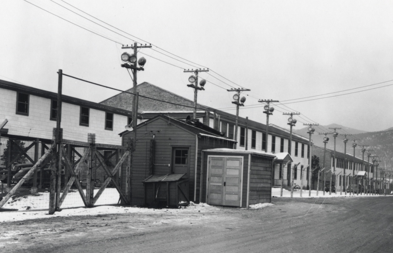
    <summary type="html"><![CDATA[<p><strong><em>As scientists raced to build the first atomic weapon during WWII, they were required to sacrifice their time, academic careers, energy, bathtubs, and more in the remote desert highlands of New Mexico. </p></strong></p><img src="https://www.intermountainhistories.org/files/fullsize/81238fa6d58203850c43f89b67708cda.jpg" alt="Los Alamos Infrastructure " /><br/><p>As World War II raged into the 1940s, each country in the war was an avid participant in the race for scientific advancement. With such high stakes, the United States invested two billion dollars—over $33 billion today—in the creation of the atomic bomb. This massive project was dubbed the Manhattan Project, after its headquarters in New York, despite largely taking place in the remote highlands of New Mexico.</p><p><span style="font-weight:400;">While the United States had fiscal resources to invest in the project, they did not have much time. Both the Germans and the Soviets were developing their own nuclear weapons, and it seemed that whoever discovered how to harness the power of the atom first would win the war. The speed and urgency of the venture inevitably meant that some details were overlooked. Construction teams were tasked with building housing for thousands of men, women, and children in the remote deserts of New Mexico in total secrecy. The workmanship of many of these early houses was shoddy at best. Project builders were not only short on time, but materials. In particular, iron was a scarce resource and largely reserved for the war effort. Understandably, it could hardly be used for iron bathtubs. Due to these factors, the majority of scientists, military personnel, and their families lived in small, relatively iron-less, hastily built homes with only a few variations of bathroom fixtures—none of which included bathtubs. </span>
<span style="font-weight:400;">Only a single row of houses had the luxury of bathtubs because they were built before the war and had originally belonged to teachers of a secondary boys’ ranch school. These “master cottages” were some of the only buildings already built when the government bought the land and were a coveted luxury. Reserved for men such as Nobel-Prize winning Englishman Sir James Chadwick, explosives expert George Kistiakowsky, bomb designer Max Roy, ordnance director William S. “Deak” Parsons, and head scientist Robert J. Oppenheimer, bathtubs were a sign of prestige in this secret New Mexico town. According to local legend, Alice Kimball Smith, wife of scientist Cyril Smith, coined the term “bathtub row.” This effectively differentiated between the comfortable ranch school homes with bathtubs and those of government construction with showers.</p>
<span style="font-weight:400;">Despite the obvious disparity, many on Bathtub Row were willing to share their good fortune. Robert Oppenheimer was reportedly a generous host who invited many in the community into his home for classified discussions, drinks, and dinner parties. Ordnance director William S. Parsons’ home was fortunate enough to have two bathtubs. He often allowed military men to use them if they were injured and unable to stand for long periods of time under a shower. These bathtubs were also used to entice babysitters who would be rewarded with a relaxing soak in their neighbor’s home in exchange for an afternoon taking care of the owners’ children.</p>
<span style="font-weight:400;">Today, these houses are privately owned, but remain part of the Los Alamos National Historical Landmark District. In 2007, the Los Alamos population petitioned to change the street name from 20th to Bathtub Row. The community has continued to embrace this humorous anecdote from WWII through naming the local brewing co-op after the iconic row of houses. It stands as a reminder of the simple luxuries many relinquished in favor of supporting the American effort during WWII. </span>

</p><p><em><strong><a href="https://www.intermountainhistories.org/items/show/751">For more (including 10 images) view the original article</a></strong></em></p>]]></summary>
    <published>2023-09-08T00:39:58+00:00</published>
    <updated>2026-04-17T19:32:16+00:00</updated>
    <link rel="alternate" type="text/html" href="https://www.intermountainhistories.org/items/show/751"/>
    <id>https://www.intermountainhistories.org/items/show/751</id>
    <author>
      <name>Abigail Beus, Brigham Young University</name>
    </author>
  </entry>
  <entry>
    <title type="html"><![CDATA[Tooele Army Depot]]></title>
    <summary type="html"><![CDATA[<p><strong><em>Tooele Army Depot (TEAD) is a United States Army Joint Munitions Command post in Tooele County, Utah. It serves as a storage site for war reserve and training ammunition. TEAD is housed on 23,610 acres with 1,093 buildings, 902 igloos and storage capacity of 2,483,000 square feet .</em></strong></p><img src="https://www.intermountainhistories.org/files/fullsize/80dfd0efc8ef671d3227f440c13c0a93.jpg" alt="The Storage at Tooele Army Depot" /><br/><p><span style="font-weight:400;">The Tooele Ordnance Depot was activated in December 1942, occupying 24,732 acres near the city of Tooele, Utah. Originally part of the U.S. Army Depot System Command (DESCOM), its mission was to provide a reserve storage depot which would have the following responsibilities: store vehicles, small arms, and fire control equipment, and to overhaul and modify tanks and tracked vehicles.  </span>
<span style="font-weight:400;">The Army chose the desert site near Tooele for four reasons: first, it was situated far enough inland from the West Coast to be defendable from attack by sea or air; second, the sandy loam soil of the area absorbed shocks--a necessary feature in case of accidental detonation or bombing; third, the site was adjacent to the Great Salt Lake Desert where ammunition, artillery pieces and vehicles in storage would be less vulnerable to ruse and corrosion in the dry climate, and finally, the site, which had been formerly used for sheep grazing, was uninhabited and with no existing structures. </span>
<span style="font-weight:400;">Blowing sands and shifting soils were immediately encountered by construction crews, hampering construction efforts and forcing delays and shutdowns. Despite these and other problems, the contract was completed by January 1943. The problem of shifting soils was not alleviated, however, until later that year when Utah State University personnel planted drought resistant grasses to prevent further erosion.</span>
<span style="font-weight:400;">The Lanham Housing Project, known as Tooele Ordnance Depot Park, originally included permanent community facilities as well as housing. The quarters for the expanded World War II workforce included such amenities as a shopping center, a post office, and an elementary school. Six community buildings (Buildings 1001-1005) remain, but the housing units were declared excess following World War II and were either sold or demolished in the following years.</span>
<span style="font-weight:400;">During WW2, the depot received and shipped a total of 40,946 railroad carloads of  ammunition supplies and salvage items, handling more than 1,625,000 tons of material. In addition, the depot overhauled or salvaged 997 major auto vehicles, 1,347 major artillery pieces, and 896 tanks. In 1949, the depot assumed command of the Deseret Chemical Depot.  </span>
<span style="font-weight:400;">During the Korean War, the depot's major emphasis would shift from a storage unit to a manufacturing enterprise devoted to producing, rebuilding, and repairing military equipment. In 1952, TEAD was selected by Ordnance Ammunition Command (OAC) to develop Ammunition Peculiar Equipment (APE) for use in all depots munitions operations. </span>
<span style="font-weight:400;">In 1962, the depot was redesignated the Tooele Army Depot. Since that time the depot has been assigned maintenance mission responsibilities for topographic equipment, troop support items, construction equipment, generators, and various types of tactical wheeled vehicles. In 1964, TEAD assumed command and control of the non-tactical generator rail equipment repair facility located at Hill Air Force Base, Ogden, Utah. It was the sole facility in the country which provided such services. </span>
<span style="font-weight:400;">The</span><span style="font-weight:400;"> </span><span style="font-weight:400;">establishment of the Ammo Equipment Office (AEO) at Tooele was the result of a careful study</span> <span style="font-weight:400;">involving thorough analysis. AEO was</span><span style="font-weight:400;"> </span><span style="font-weight:400;">changed to the Ammunition Equipment Directorate (AED) in 1981. This changed the status of the</span><span style="font-weight:400;"> </span><span style="font-weight:400;">organization on the depot. The AED mission was now recognized as a valuable asset to the Tooele</span><span style="font-weight:400;"> </span><span style="font-weight:400;">Army Depot and was included in depot planning and programs. </span>
<span style="font-weight:400;">In 1988, the Base Realignment and Closure (BRAC) recommended that TEAD take over the general supply storage mission from Pueblo Depot Activity in Colorado. In 1993, BRAC recommended TEAD eliminate its troop support, maintenance, storage, and distribution missions. Since that decision, the Army completed the transfer of surplus property to the Redevelopment Agency of Tooele City (RDA). On January 19, 1999, the U.S. Army Materiel Command, Chief of Staff, Major General Normal E. Williams, presented a ceremonial deed commemorating the transfer of 1700 acres and 258 buildings to Tooele City. </span>
<span style="font-weight:400;">On September 28, 1999, another mark in Tooele Army Depot history took place. Once again the mission of the Defense Non-Tactical Generator and Rail Center (DGRC), command and control, transferred to another command--U.S. Army Tank-Automotive and Armaments Command (TACOM) in Warren, Michigan. In its 2005 BRAC Recommendations, the Department of Defense recommended realigning Sierra Army Depot,</span> <span style="font-weight:400;">California, by relocating Storage to Tooele Army Depot. Capacity and capability for storage existed at </span><span style="font-weight:400;"> </span><span style="font-weight:400;">numerous munitions sites. To reduce redundancy and remove excess from the Industrial Base, the</span><span style="font-weight:400;"> </span><span style="font-weight:400;">realignment would allow the Department of Defense to create centers of excellence and remove inefficiencies.  On March 1, 2010, TEAD was designated as a Center of Industrial and Technical Excellence for Ammunition Peculiar Equipment by the Secretary of the Army.</span>
<span style="font-weight:400;">During a special U.S. Army ceremony, Deseret Chemical Depot was formally closed July 11, 2014. U.S. Army officials called it a transfer of property, taking Deseret Chemical Depot's 19,000-plus acres and transferring them to Tooele Army Depot.</span>
<span style="font-weight:400;">The depot is currently the Department of Defense’s western region conventional ammunition hub for the storage, receipt, issue, maintenance, and demilitarization. It is also the center for the design, manufacture, fielding and maintenance of all Ammunition Peculiar Equipment (APE). The workforce at the post is now</span><span style="font-weight:400;"> p</span><span style="font-weight:400;">rimarily composed of civilians. A full colonel serves as the commander. As of June 2018, Colonel </span><span style="font-weight:400;">Todd W. Burnley is the depot commander.</span></p><p><em><strong><a href="https://www.intermountainhistories.org/items/show/678">For more (including 4 images) view the original article</a></strong></em></p>]]></summary>
    <published>2022-10-25T15:43:38+00:00</published>
    <updated>2026-04-17T19:32:14+00:00</updated>
    <link rel="alternate" type="text/html" href="https://www.intermountainhistories.org/items/show/678"/>
    <id>https://www.intermountainhistories.org/items/show/678</id>
    <author>
      <name>Tyrome Heath, Weber State University</name>
    </author>
  </entry>
  <entry>
    <title type="html"><![CDATA[Battle of Julesburg]]></title>
    <summary type="html"><![CDATA[<p><strong><em>After American militias massacred Cheyenne and Arapaho as part of the Civil War in the West, indigenous warriors banded together, determined to not let American colonizers’ unwarranted violence go unanswered.</em></strong></p><img src="https://www.intermountainhistories.org/files/fullsize/39ffd1ff27a2be44f963f783464803e2.jpg" alt="Battle of Julesburg" /><br/><p>In January 1865, Julesburg, Colorado was 200 miles east of Denver. Complete with an eating-house, stable, blacksmith, repair shop, granary, and corral, the town was an important waystation for immigrants and settlers traveling along the Platte River on the Oregon Trail.
However, Julesburg’s relative prominence also made it a target for Native retaliation after the Sand Creek Massacre. Six weeks earlier, on November 29, 1864, led by brevet Colonel John Chivington, the 675-men strong Third Colorado massacred several hundred Cheyenne and Arapaho men, women, and children in southeastern Colorado Territory. Dog Soldiers (a militant Cheyenne subgroup) allied with other Cheyenne, Arapaho, and Lakota warriors to avenge their relatives who died at Sand Creek. In total, they numbered some 1200 Dog Soldiers and other warriors. Sitting Bull, Spotted Tail, Pawnee Killer, and others led the attack on Julesburg. On January 7, 1865, the allied Natives found that many soldiers had left town as part of their regular patrols, leaving only 37 men to defend the fort at Julesburg.
A small group of Lakotas led the initial charge. Nicholas James O’Brien, a highly decorated Civil War soldier and commander of the troops at Julesburg, saw the oncoming attack and pursued the Lakotas, unwittingly falling into their strategic trap to encircle the soldiers once they had been separated from reinforcements. The Native alliance intended to surround the American soldiers, but some young Cheyenne left their position too early before the entrapment could be realized. Despite this minor lapse, within a few minutes of fighting, nearly half of the U.S. soldiers were killed.
O’Brien led his surviving soldiers back to the fort, and the Native alliance laid siege. The remaining tribesmen entered Julesburg and raided every building. George Bent, a Cheyenne who participated in the raid, recalled that allied Natives found all the goods they desired. Tribal women brought extra horses to carry the spoils back to their camps. The horses were so heavily loaded that it took three days to make the return trip home. The raid lasted the whole day and became the first of many Cheyenne, Arapaho, and Lakota raids conducted in the Central Plains over the coming months. The accumulation of goods brought sustenance to the tribes that winter while the United States took a staggering blow to their efforts to control American Indian affairs during the Civil War.</p><p><em><strong><a href="https://www.intermountainhistories.org/items/show/576">For more (including 4 images) view the original article</a></strong></em></p>]]></summary>
    <published>2022-03-12T07:54:28+00:00</published>
    <updated>2026-04-17T19:32:12+00:00</updated>
    <link rel="alternate" type="text/html" href="https://www.intermountainhistories.org/items/show/576"/>
    <id>https://www.intermountainhistories.org/items/show/576</id>
    <author>
      <name>Ryan Blamires, Brigham Young University</name>
    </author>
  </entry>
  <entry>
    <title type="html"><![CDATA[Camp Floyd Cemetery]]></title>
    <summary type="html"><![CDATA[<p><strong><em>Although Camp Floyd was one of the largest United States military installations before the Civil War, it was abandoned just three years after being created. Evidence of the camp’s over-3,000 residents is now almost non-existent, except for the Camp Floyd Cemetery that remains today in Fairfield, Utah. </em></strong></p><img src="https://www.intermountainhistories.org/files/fullsize/83e417a02d918c705de46f13a17d6a0d.jpg" alt="Unknown soldiers" /><br/><p>In 1858, President James Buchanan sent United States Army General Albert Johnston and 2,500 troops to the Utah Territory to protect newly-appointed territorial leaders and put an end to a suspected rebellion. In response, the Brigham Young, territorial governor and president of The Church of Jesus Christ of Latter-day Saints (sometimes called Mormons) declared martial law and mobilized for war. What became known as the “Utah War'” or “Utah Expedition” began.  Johnston’s army survived a harsh winter and a few raids from Latter-day Saints before they ultimately concluded that the Mormons were not in rebellion against the United States. The troops subsequently passed through the Salt Lake Valley and established a camp at Fairfield, a sparsely populated village that was far from major Latter-day Saint settlements. Johnston’s army called it “Camp Floyd'' after the then secretary of war, John B. Floyd.
Camp Floyd became a lively town with a population of more than 7,000 people at its peak. Then, in 1861, the United States redeployed the soldiers to the eastern theater of the escalating Civil War, leaving Camp Floyd completely abandoned. Almost nothing of the soldiers’ homes or the dugouts where they lived remains today. At the site, the old commissary building now serves as a state park museum, along with the Stagecoach Inn which was used in the overland trade that continued after the soldiers abandoned Camp Floyd. The only other evidence that remains of this once bustling military settlement is the cemetery where the soldiers and officers who perished there were buried.
Scholars believed that 84 people were buried in or close to the Camp Floyd Cemetery. Research has revealed that some of the people who buried there were not Camp Floyd soldiers. The actual location of all these 84 people’s remains is unknown. In 1913, those buried here were commemorated by one large headstone that was made from the stones of army barracks at Camp Floyd. After the land was turned over to the Utah State Park and Recreation Commission in 1959, the American Legion placed 84 headstones, evenly spaced throughout the cemetery. In 2009, researchers used ground penetrating radar technology, revealing the location of 33 bodies. In light of that discovery, in 2011, Camp Floyd State Park replaced the headstones to specifically mark the identified locations of the unidentified bodies. The park also added a sign at the entrance describing the people buried.</p><p><em><strong><a href="https://www.intermountainhistories.org/items/show/562">For more (including 4 images) view the original article</a></strong></em></p>]]></summary>
    <published>2021-12-18T07:05:42+00:00</published>
    <updated>2026-04-17T19:32:12+00:00</updated>
    <link rel="alternate" type="text/html" href="https://www.intermountainhistories.org/items/show/562"/>
    <id>https://www.intermountainhistories.org/items/show/562</id>
    <author>
      <name>Larissa Barnes, Brigham Young University</name>
    </author>
  </entry>
  <entry>
    <title type="html"><![CDATA[Desert National Wildlife Refuge and Competing Agendas in Nevada]]></title>
    <summary type="html"><![CDATA[<p><strong><em>Desert National Wildlife Refuge encompasses a large portion of southern Nevada, spanning from Area 51 to the northern tip of the greater Las Vegas area, and is part of a wildlife refuge complex protecting Nevada’s unique and rare species. However, the Nevada desert offers promising opportunities for many, and the contest for its usage is seemingly never-ending.</em></strong></p><img src="https://www.intermountainhistories.org/files/fullsize/74cfd8c703bc5ebd8b073c9827586909.jpg" alt="Petrogylphs at Desert NWR" /><br/><p>Desert National Wildlife Refuge (Desert NWR), the largest national wildlife refuge in the contiguous United States, spans vast tracts of land in Nevada. Adjacent to the Nevada Nuclear Test Site and overlapping the Nellis Air Force Range, the refuge and surrounding preserves form the Desert National Wildlife Refuge Complex, home to several rare and endangered species such as the Devils Hole pupfish. Though established to preserve Nevada’s natural landscape, various interest groups in the region are in continual conflict over how to use Desert NWR, some sharing its preservationist goals and some not.
The US Fish and Wildlife Service created Desert NWR in 1936 primarily to protect desert bighorn sheep. In doing so, the government also recognized southern Nevada’s high biodiversity and varied desert environments, from the oasis of Ash Meadows to the landscape of the Great Basin. However, not all shared this appreciation. When military officials searched for a place to test nuclear weapons in the wake of World War II, they chose Nevada’s “wasteland” as the site that would generate the least collateral damage. The Nuclear Test Site settled in Nye County, Nevada in 1951, coming to rest on land that the Shoshone people had called home for millennia.
The Western Shoshone Nation quickly challenged the military’s appropriation, pointing to the terms set in the 1863 Treaty of Ruby Valley. Though the US government had acknowledged Shoshone sovereignty in the region, they still asserted that their nuclear agendas took precedent. In addition to the Western Shoshone’s rights to the land, the environmental impact of nuclear testing quickly became a pressing issue due to how far wind carried radioactive remnants of bomb tests. The Test Site terminated above-ground testing in the 1990s and fully closed in 2010. In the late 2010s and early 2020s, however, the federal government continued to encroach on the refuge’s land. Conflicts about the nearby Air Force range have proposed both expanding and withdrawing its reaches, with the debate still ongoing. The presidency of Donald Trump even reopened discussions on the proposed nuclear waste site at nearby Yucca Mountain.
The prevalent and continued debate over Nevada desert land shares fundamental elements with many land rights conversations in the West. Paiute and Shoshone presence within the Refuge confines is impossible to ignore, especially with petroglyphs and sacred sites scattered across the landscape. Military presence also touches upon another sensitive topic in Western states—the overwhelming amount of federally-owned land. Much of the strong Nevadan opposition to test site expansion stems from resentment towards the government, as many feel that the state government should maintain more dominion over local land. Yet the state itself continues to violate the dominion of those who have used the land far longer than any Nevada citizen. For a so-called wasteland, the deserts of southern Nevada draw much attention.</p><p><em><strong><a href="https://www.intermountainhistories.org/items/show/545">For more (including 4 images) view the original article</a></strong></em></p>]]></summary>
    <published>2021-12-17T01:03:55+00:00</published>
    <updated>2026-04-17T19:32:11+00:00</updated>
    <link rel="alternate" type="text/html" href="https://www.intermountainhistories.org/items/show/545"/>
    <id>https://www.intermountainhistories.org/items/show/545</id>
    <author>
      <name>Len Truelsen, Northern Arizona University</name>
    </author>
  </entry>
  <entry>
    <title type="html"><![CDATA[Camels at Fort Defiance]]></title>
    <summary type="html"><![CDATA[<p><strong><em>The US government brought camels to the Southwest to use them in the short-lived US Camel Corps, formed in 1857 and lasting until 1863, which experimented with the pack animals for military use. Lieutenant Edward Fitzgerald Beale used them to survey a wagon route from Fort Defiance to the Colorado River, charting the “dim, uncertain, and unknown.”</em></strong></p><img src="https://www.intermountainhistories.org/files/fullsize/746aac8579a2592361a2a2a65a514dba.jpg" alt="Camel camp" /><br/><p>Fort Defiance marks the starting point of Lieutenant Edward Fitzgerald Beale’s 1857–1858 wagon road survey across the 35th parallel to the Colorado River, the very first deployment of the US Camel Corps. The government was eager to boost the efficiency of transport and trade between the East and California and furthermore wanted to survey the land acquired from the Mexican government after the Mexican–American War. Recommendations by military officials such as Major Henry C. Wayne eventually resulted in two shipments of camels, as well as camel handlers such as the Arizona-famous Hi Jolly, docking at Indianola, Texas, on May 14, 1856. From there they were moved to a fort near San Antonio. Lieutenant Beale, appointed by Major Wayne to use this Camel Corps for the wagon road survey, set out from San Antonio with twenty-eight camels on June 25, 1857.
Along the way to Fort Defiance, Lieutenant Beale was to meet up with a Colonel Loring, a general who had lost one arm in the Mexican War and would later go on to help train troops in Egypt. At this early date, however, he was unacquainted with camels, and Beale rather literally left him in the dust, as the camel Beale was riding easily outpaced Loring’s horse. They met back together some two days later and reached Fort Defiance together on August 25, 1857.
Colonel Edwin Vose Sumner established Fort Defiance to assert dominance over the Navajo population with a military presence. Lacking defensive fortifications, however, it took the form of a “military village,” with barracks, stables, storehouses, a civilian trading store, a hospital, and a structure for Navajos staying overnight, all arrayed around a parade ground. At this time, the fort held a tentative peace with the Native Americans of the region. They traded with the Zuni and the Navajo for food, but the fort occupied what had been grazing land, and occasional raids continued. While 1856–1857 was relatively quiet around the vicinity of the fort, Beale’s careful notes of any Native American sightings or interactions on his journey demonstrate the government’s uneasy relationship with the native inhabitants of the territory.
When he reached Fort Defiance, Beale wrote in his journal that “No one who has not commanded an expedition of this kind, where everything ahead is dim, uncertain, and unknown, except the dangers, can imagine the anxiety with which I start upon this journey.” Beale himself had already led an expedition such as this, charting a “Central Route” to California in 1853 from Missouri. Seeing the camels’ performance on this expedition from Fort Defiance left Beale with great admiration for their ability to carry enormous loads, travel great distances, and go long periods of time without water. He even developed a particular affinity for one camel named Seid.  Even after the Camel Corps was officially disbanded, Beale kept a collection of camels at his ranch near Fort Tejon, California.</p><p><em><strong><a href="https://www.intermountainhistories.org/items/show/525">For more (including 5 images) view the original article</a></strong></em></p>]]></summary>
    <published>2021-10-20T09:06:17+00:00</published>
    <updated>2026-04-17T19:32:11+00:00</updated>
    <link rel="alternate" type="text/html" href="https://www.intermountainhistories.org/items/show/525"/>
    <id>https://www.intermountainhistories.org/items/show/525</id>
    <author>
      <name>Emily Moore, Northern Arizona University</name>
    </author>
  </entry>
  <entry>
    <title type="html"><![CDATA[The Haunted Hotel Colorado]]></title>
    <summary type="html"><![CDATA[<p><strong><em>Glenwood’s Hotel Colorado has not only been a popular resort for figures such as Teddy Roosevelt and the Chicago Mafia; it also boasts several ghosts.</em></strong></p><img src="https://www.intermountainhistories.org/files/fullsize/24efddf4f696ca2871cedeca1935bab9.jpg" alt="Hotel Colorado" /><br/><p><span style="font-weight:400;">The sprawling Hotel Colorado in Glenwood Springs was finished in 1893 for a total of $850,000. The hotel’s founder, Walter Devereux, was an early settler of Glenwood Springs and hoped to take advantage of the flock of visitors coming to see Glenwood’s hot springs and Colorado’s booming mining business. In 1974, the hotel was designated as a National Historic Landmark, and in 2018 the hotel celebrated 125 years in business. However, many claim that there are some more permanent guests as well, and these ghosts have garnered the Hotel Colorado a reputation as one of the top ten most haunted hotels in Colorado. </span>
<span style="font-weight:400;">The Hotel Colorado had a rotation of famous and wealthy visitors soon after its construction, and as such the grounds boasted incredible amenities. The hotel’s nickname during the height of its splendor was the “Grande Dame,” and it lived up to these expectations. The hotel possessed an indoor waterfall as well as a garden and bird sanctuary. It even had its own railroad spur so that wealthy individuals could store their private railroad cars during their stay. During a three-week hunting trip, the hotel served as a temporary residence for President Theodore Roosevelt. This is where the myth of the teddy bear was born when the staff put together a teddy bear to cheer up the president after a bad day of hunting. However, such decadence was not to last. </span>
<span style="font-weight:400;">After the Great Depression, the hotel was leased to the United States Navy as a medical facility and stripped bare in order to meet sanitary requirements. The basement gained a crematorium and morgue as well as a brig, as US Naval law requires a brig wherever naval men are stationed. From 1943 to 1946, the hospital served around 6,500 patients, many of whom died there. After the Navy decommissioned the hospital, the hotel passed through many owners and fell further into disrepair until it was declared a national historic landmark in 1974 and Kirk Whitely began restoration. However, in 1988, the bank foreclosed on the property. It wouldn’t be until the 1990’s that the hotel was restored to its former glory.</span>
<span style="font-weight:400;">Today, the hotel offers a nocturnal history tour and has a page about its ghosts online. The area with the most activity has been identified as the basement, due to the naval cremation and morgue activities that happened there. Some ghosts are so distinctive that they have been given names. Bobbie is a ghost who is known for her distinct perfume and likes to appear in the dining hall. Walter is perhaps the best known of the ghosts and may actually be the third owner of the hotel, Elmer Lucas. Whatever one’s beliefs about the paranormal, the Hotel Colorado remains a staple in both the haunted and tourist history of Colorado.</span></p><p><em><strong><a href="https://www.intermountainhistories.org/items/show/472">For more (including 4 images) view the original article</a></strong></em></p>]]></summary>
    <published>2021-09-10T08:52:52+00:00</published>
    <updated>2026-04-17T19:32:09+00:00</updated>
    <link rel="alternate" type="text/html" href="https://www.intermountainhistories.org/items/show/472"/>
    <id>https://www.intermountainhistories.org/items/show/472</id>
    <author>
      <name>Nikki Smith, Brigham Young University</name>
    </author>
  </entry>
  <entry>
    <title type="html"><![CDATA[Echo Lake Park]]></title>
    <summary type="html"><![CDATA[<p><strong><em>Primarily known for its recreational sites, Echo Lake Park is not only a historic physics site but also the home of a WWII high altitude training center.</em></strong></p><img src="https://www.intermountainhistories.org/files/fullsize/40a2c39dbbb737d60610ca0405e87236.jpg" alt="Echo Lake" /><br/><p><span style="font-weight:400;">Echo Lake Park is located at about 10,600 feet above sea level along the Mount Evans Scenic Byway. Ever since the Mount Evans Crest House at the top of the Mount Evans Scenic Byway burned down in 1979, Echo Lake has served as the primary lodging and stop for visitors to the area. Echo Lake hosts a variety of activities and also features two surprising historical sites. Visitors coming to fish at the lake or hike the trails might be surprised to find laboratories that were used to research cosmic radiation. Similarly, those stopping to get a meal at Echo Lake Lodge might be surprised by its wartime history.</p><span style="font-weight:400;">The Echo Lake laboratories along with the High-Altitude Laboratory at Mount Evans were designated as a Historic Physics site in October 2017. Once, the laboratories were run in conjunction by the University of Chicago, Cornell, the University of Denver, MIT, NYU, and Princeton. Now the University of Denver oversees the site. Research began in 1935, just four years after the Mount Evans Scenic Byway opened to the public. Although it was easier for the cosmic rays to be studied at the higher elevations, Echo Lake played an important role in the research because it was accessible during the winter. At both laboratories, scientists studied radiation and even proved Einstein’s prediction of time dilation to be true.</p><span style="font-weight:400;">In addition to the laboratories, Echo Lake Park is also home to the Echo Lake Lodge. It was originally constructed by the City and County of Denver so that visitors from Denver could have a place to stay while visiting the Mount Evans Scenic Byway. However, it was handed over to H. W. Stewart Inc in 1965. This group continues to run the house to the present day. Individuals can stay and eat at the lodge, which once served as a high-altitude military training camp during World War II. The lodge became the primary stopping point for tourists after the Mount Evans Crest House, built at the top of the Mount Evans Scenic Byway, burned down in 1979.</span></p><p><em><strong><a href="https://www.intermountainhistories.org/items/show/470">For more (including 4 images) view the original article</a></strong></em></p>]]></summary>
    <published>2021-09-10T08:11:02+00:00</published>
    <updated>2026-04-17T19:32:09+00:00</updated>
    <link rel="alternate" type="text/html" href="https://www.intermountainhistories.org/items/show/470"/>
    <id>https://www.intermountainhistories.org/items/show/470</id>
    <author>
      <name>Nikki Smith, Brigham Young University</name>
    </author>
  </entry>
  <entry>
    <title type="html"><![CDATA[1878 Bannock War and Chief Buffalo Horn]]></title>
    <summary type="html"><![CDATA[<p><strong><em>By rebelling against the United States military, Chief Buffalo Horn took initiative in improving the livelihood of the Bannocks after their relocation to the Fort Hall Reservation. Although his death did not immediately end the war, the Bannocks eventually returned to the reservation, forced to deal with confinement and limited resources.</p></strong></p><img src="https://www.intermountainhistories.org/files/fullsize/6a9d7b8c29f4bf5b5dd2d6d43ed102bc.jpg" alt="Bannock Camp" /><br/><p>The first Bannock War against the United States military occurred in 1878. With close ties to the Shoshones, groups of Bannocks and Paiutes joined together to oppose confinement at Fort Hall in southern Idaho. Reasons for action included limited agricultural opportunities, lack of promised supplies, and discontent with their treatment by the American military.</p><p>The Bannocks and Shoshones exhibited friendship toward Americans during the fur trade in the first half of the 19th century. Relations turned sour when the fur trade declined and increasing numbers of permanent American settlers encroached upon tribal homelands and consumed native resources without compensation. Additionally, as native peoples’ land and resources diminished, so did their ability to maintain independence. During the 1860s, treaties held at Fort Bridger and Box Elder in 1863 and 1868 relocated indigenous people to the Fort Hall reservation.</p><p>Although the U.S. government required that the Bannocks remain on the reservation, in the summer of 1877, many natives left the territorial limits dissatisfied with their current situation. Despite threats of military involvement, the Bannock rebellion and subsequent war quickly commenced in May 1878, perhaps because the Bannocks felt that the United States had failed to fulfill treaty obligations.</p><p>Bannock leader Chief Buffalo Horn mobilized several hundred Bannocks, adding additional Paiute allies to augment their numbers. These warriors engaged in a sequence of attacks along the Snake River, raiding settlements and even killing some settlers who opposed them. Word reached American leadership in Boise, who called upon military action to force Chief Buffalo Horn’s men to surrender. In early June, Chief Buffalo Horn and his accompanying warriors briefly fought against a small volunteer group of militiamen, resulting in a few casualties, including the fatality of Chief Buffalo Horn. Chief Egan took his place until the Umatilla people, posing as allies, killed him to collect an alleged bounty reward offered by the United States.</p><p>The remaining Bannocks separated into smaller groups or surrendered and returned to Fort Hall by August 1878. Following this resolution, the U.S. government carefully monitored Bannock movement within the reservation, limiting their use of local resources and interactions with local native groups. As a result of their surrender, the Bannocks conceded to rebuilding their livelihood on the allotted territory on the Fort Hall reservation. </p><p><em><strong><a href="https://www.intermountainhistories.org/items/show/412">For more (including 6 images) view the original article</a></strong></em></p>]]></summary>
    <published>2020-03-20T00:38:31+00:00</published>
    <updated>2026-04-17T19:32:08+00:00</updated>
    <link rel="alternate" type="text/html" href="https://www.intermountainhistories.org/items/show/412"/>
    <id>https://www.intermountainhistories.org/items/show/412</id>
    <author>
      <name>Camilla Richardson, Brigham Young University</name>
    </author>
  </entry>
  <entry>
    <title type="html"><![CDATA[Nez Perce and Bannock Flight Through Yellowstone National Park]]></title>
    <summary type="html"><![CDATA[<p><strong><em>The Nez Perce and Bannock Wars were sparked by increasing federal involvement in Indian affairs and Native rejection of reservation life and its implications. During both wars, groups traveled through the newly created Yellowstone National Park, hoping to find refuge in familiar territory as they tried to reach Canada.</em></strong></p><img src="https://www.intermountainhistories.org/files/fullsize/5518ac3fda9f6bef77651017d5de6dfb.jpg" alt="Chief Joseph" /><br/><p>By the late 1870s, the United States government was fully engaged in the process of forcing American Indians in the West onto reservations. In 1855, Nez Perce in Oregon, Idaho, and Washington signed a treaty in which they accepted a 5,000-square-mile reservation. Later, in 1869, their reservation was reduced in size following the discovery of gold on their land. A division grew between some converted Christian Nez Perce who supported treaties and traditional Nez Perce who refused to live on the reservation. One traditional Nez Perce leader argued, “I belong to the land out of which I came.” Groups led by White Bird, Looking Glass, and Chief Joseph separated from the treaty group. In June of 1877, a violent outburst from White Bird’s group left four white settlers dead. The anti-treaty Nez Perce feared retaliation and fled in an effort to join Sitting Bull in Canada.</p><p>The Nez Perce headed through Yellowstone National Park in late August. Yellow Wolf recalled that Nez Perce scouts “knew that country well before passing through there in 1877. The hot springs and high-shooting water were nothing new to us.” On their second day in the park, scouts found a group of tourists and held the party captive for two days. Following a skirmish that left one of the tourists severely wounded, they were released. Some anxious scouts would attack other groups and kill two tourists. The Nez Perce were able to outmaneuver the army as they exited the park, and almost reached Canada before being forced to surrender in October at the Battle of Bear Paw. Around sixty Nez Perce were able to escape during the battle, including White Bird and Chief Joseph’s daughter, who successfully joined the Lakota in Canada. Between 1878 and 1880, many of them returned to Idaho. </p><p>Similarly, in 1878, Bannocks faced starvation at Fort Hall. Ranchers had destroyed important camas bulb pastures, their main source of food, and the government neglected to supplement with sufficient rations. Many Bannocks left the reservation and clashed with white farmers and federal troops. A small band headed north, following the Nez Perce route through Yellowstone National Park, hoping to reach Canada. They were ambushed east of the park in September, and the uprising was eventually quelled by federal troops. Restrictions were placed on the Fort Hall Reservation and most of the insurgents were split up between allotments and other forts.  </p><p>These conflicts damaged Yellowstone’s public relations image and park officials would work hard to assuage tourist fears of an Indian threat. Some tourists found the battles exciting, and in efforts to live out fantasies about the ‘wild west’ joined expeditions following the path used by the Nez Perce and Bannock. Others feared continued Indian contact and avoided the area altogether. The wars also caused a shift in military management of the park; officials would use the conflict to justify military necessity to the park’s success and took a firm stance against Indian presence in the park. </p><p><em><strong><a href="https://www.intermountainhistories.org/items/show/345">For more (including 4 images) view the original article</a></strong></em></p>]]></summary>
    <published>2019-09-26T01:22:58+00:00</published>
    <updated>2026-04-17T19:32:06+00:00</updated>
    <link rel="alternate" type="text/html" href="https://www.intermountainhistories.org/items/show/345"/>
    <id>https://www.intermountainhistories.org/items/show/345</id>
    <author>
      <name>Allie Patterson, Brigham Young University</name>
    </author>
  </entry>
  <entry>
    <title type="html"><![CDATA[Rosebud Battlefield State Park and General Crook]]></title>
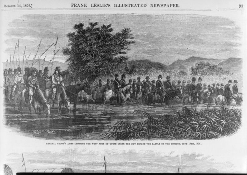
    <summary type="html"><![CDATA[<p><strong><em>At Rosebud Creek, Montana, Northern Cheyenne and Sioux warriors attacked Brigadier General George R. Crook's forces in June 1876. Crook's complex philosophical differences with General Philip Sheridan, and his sympathetic sentiments toward the plight of his Indian adversaries, influenced his cautious, tactical decisions in the days following the battle.</em></strong></p><img src="https://www.intermountainhistories.org/files/fullsize/baff63751c5ff6ce3544c63a1971fbcd.jpg" alt="General Crook&#039;s Army before the Battle of Rosebud" /><br/><p>In January, 1876, the Sioux failed to report to the reservation at Standing Rock, Dakota Territory, after being driven off their homeland by the United States' attempt to accommodate the Black Hills gold rush.  General George Crook's forces deployed from Fort Fetterman in May 1876 in pursuit of the Sioux and their Northern Cheyenne allies. The expedition consisted of over 1,000 soldiers and civilians. Among the latter were teamsters, packers, and five journalists. On June 17, 1876, Sioux and Northern Cheyenne warriors, led by Crazy Horse and Two Moon attacked Crook's first Yellowstone Expedition.       </p><p>In response, Crook deployed his cavalry to control high ground to the North and East of Rosebud Creek. “They were from two or three miles distant, coming at full speed towards us, cheering,” Captain Anson Mills recounted. The infantry formed an inner defensive perimeter, while the packers remained in a fracas behind a rocky outcropping known today as 'Packers Rocks'. The following six hours consisted of a cacophony of gunfire, yelling, dust, smoke, stench, and screams. During the melee, a Cheyenne warrior, Comes In Sight, had his horse shot out from under him. A young Cheyenne woman rode out to his rescue. The Northern Cheyenne say she was Buffalo Calf Road Woman, the sister of Comes In Sight. The Cheyenne remember the conflict as 'Where the girl saved her brother'. At approximately 2pm, Crook ordered his men to disengage, fearing a greater ambush from the North.                                             </p><p>The Army's official casualty report was ten killed in action with thirty wounded.  The Department of Interior revised the number to include fifty seven wounded.  Crazy Horse and Two Moon had reported their losses at twenty seven killed and sixty three wounded.. General Anson Mills recalled, “We then all realized for the first time that while we were lucky not to have been entirely vanquished, we had been most humiliatingly defeated.”  After the battle, a dejected General Crook responded to counter attack orders from General Philip Sheridan, “I wish Sheridan would come here himself and show us how to do it. It is rather difficult to surround three Indians with one soldier.” </p><p>Eight days following the engagement at Rosebud Creek, the Sioux and Northern Cheyenne annihilated five companies of the 7th Cavalry under the command of Lieutenant Colonel George A. Custer, less than fifty miles north at Little Big Horn Creek. This fact has led many historians to criticize Crook's decision to withdraw from the battle and return the Yellowstone Expedition to Fort Fetterman and Camp Cloud Peak to re-supply and rest.  They have also critiqued Crook's reluctance to counter attack as being a contributing factor to the defeat at the Battle of the Little Bighorn.</p><p>The secluded 3,052 acres of Rosebud Battlefield State Park were in ranch lands until acquired by the state of Montana in 1978. Thirty years later, the National Park Service designated this scenic valley as a National Historic Landmark.</p><p><em><strong><a href="https://www.intermountainhistories.org/items/show/338">For more (including 4 images) view the original article</a></strong></em></p>]]></summary>
    <published>2019-09-18T04:05:54+00:00</published>
    <updated>2026-04-17T19:32:06+00:00</updated>
    <link rel="alternate" type="text/html" href="https://www.intermountainhistories.org/items/show/338"/>
    <id>https://www.intermountainhistories.org/items/show/338</id>
    <author>
      <name>Robert M. Estrada, Northern Arizona University</name>
    </author>
  </entry>
  <entry>
    <title type="html"><![CDATA[Fort Verde State Park and General Crook]]></title>
    <summary type="html"><![CDATA[<p><strong><em>Brigadier General George R. Crook (September 8, 1828 -March 21, 1890) is popularly recognized as the quintessential 'Indian Fighter' of the late nineteenth century, despite the fact that he sometimes expressed anger not at the native peoples but toward the interfering white settlers. In 1871 Crook's forces deployed from Fort Verde in the northern Arizona Territory in pursuit of the Tonto Apache.</em></strong></p><img src="https://www.intermountainhistories.org/files/fullsize/6c733c5983f11c9a8df63d66a11a7fcc.jpg" alt="Married Officers&#039; Quarters" /><br/><p>General George R. Crook used Fort Verde in northern Arizona Territory as his primary base of operations for the unenviable task of relocating Apache tribes in the Arizona territory onto reservations. Located at the confluence of the East Fork of Beaver Creek and the 'Rio' Verde River, at the base of the Colorado Plateau, Fort Verde housed officers, doctors, enlisted men, families, and scouts. Many of the officers' wives enjoyed their time at the fort because of its many modern amenities including, bath tubs, silver ware, and draperies. Martha Summerhayes (wife of Lt. John Summehayes) recounted that she felt as though they had finally reached “civilization” when arriving at Fort Verde. </p><p>Crook's objective at Ft. Verde was to provide protection to the early settlers, the Butterfield Stage, and to facilitate the removal of all Indians from both Verde Valley and the Tonto Basin to the east. Crook appreciated the necessity of recruiting scouts. Captain John G. Bourke remembered, “There were Navajoes(sic), Apaches, Yaquis, Mexicans, and half-breeds of any tribe one could name.” Among the most celebrated scouts were Alchesay, and Chiquito, both of whom received the Medal of Honor for their actions against the Tonto Apache. Crook also admired how   “Our Indian allies would crawl upon their hands and knees for long distances.” in pursuit of renegades.  Crook especially appreciated this dedication given the challenge of the rugged Tonto terrain north of the fort, “There is hardly a space of ten miles square, that has not some lava bed, precipitous canyons, or caves with which the Indians can hold out.” After three years of driving the Tonto Apache from their rugged homeland, the Army force marched the survivors 180 miles to the reservation at San Carlos. The War Department  also required the peaceful Yavapai people to join their Apache neighbors on the journey referred to as the 'Exodus'.    </p><p>Ironically, one of the greatest challenges for the Army was protecting the Indians from the homesteaders. In a letter to General Philip H. Sheridan, Crook described, “There are large flocks of human vultures wrangling over the patronage to be bestowed, and who in greed do not hesitate at any deed; the complications arising can be imagined.” The most egregious incident resulted in the death of a young cavalry officer in a conflict with local settlers.  Lieutenant Jacob Arny lost his life, defending the Indians from the settlers.  Despite Crook's request for punishment, the courts never prosecuted the locals responsible for the deed.  </p><p>The State of Arizona established Fort Verde State Park in 1972, in recognition of it being the finest, preserved military facility of the Indian Wars in the state. The Park features the former administrative building, the doctor's quarters, the officer's quarters, the married officer's quarters, and a significant collection of military artifacts.</p><p><em><strong><a href="https://www.intermountainhistories.org/items/show/337">For more (including 4 images) view the original article</a></strong></em></p>]]></summary>
    <published>2019-09-18T03:58:22+00:00</published>
    <updated>2026-04-17T19:32:06+00:00</updated>
    <link rel="alternate" type="text/html" href="https://www.intermountainhistories.org/items/show/337"/>
    <id>https://www.intermountainhistories.org/items/show/337</id>
    <author>
      <name>Robert M. Estrada, Northern Arizona University</name>
    </author>
  </entry>
  <entry>
    <title type="html"><![CDATA[Fort Fetterman State Historic Site and General Crook]]></title>
    <summary type="html"><![CDATA[<p><strong><em>Brigadier General George R. Crook (September 8, 1828 -March 21, 1890) is popularly recognized as the quintessential 'Indian Fighter' of the late nineteenth century, despite expressing sympathy for his native adversaries. In the summer of 1876, Crook's forces deployed from Fort Fetterman in central Wyoming on three Yellowstone Expeditions to force the Plains Indians onto reservations.</em></strong></p><img src="https://www.intermountainhistories.org/files/fullsize/ab8b9b567b5421ec48af7c746016a2a0.jpg" alt="Fort Fetterman, 1876" /><br/><p>In 1876, Fort Fetterman, near present-day Douglas, Wyoming, served as the embarkation site for General George Crook's three Yellowstone Expeditions into the Powder River region. General Philip H. Sheridan ordered Crook to facilitate the relocation of the Sioux and Northern Cheyenne onto the reservations at Standing Rock and Pine Ridge, Dakota Territory, after they had been driven from the Black Hills.  Crook had the support from the 7th Cavalry of Lieutenant Colonel George A. Custer to the North and General J.J. Reynold's 2nd Cavalry to the East. </p><p>The Fort had been named for Captain William J. Fetterman, who was killed on December 21, 1866 near Fort Kearney, Wyoming. A year later, the army constructed Fort Fetterman to provide protection for European Americans traveling west on the Bozeman trail. After the Fort Laramie Treaty of 1868, Ft. Fetterman became the most remote outpost on the Northern Plains.               </p><p>The journey to Fort Fetterman possessed its own share of hardship. To reach the fort, it was necessary for troopers and teamsters to cross the high spring waters of the North Platte.  The fast current made it necessary to ferry the mules across the river, “because the animals would not approach the swollen Platte; here they showed more sense than the men in charge” recounted Captain John G. Bourke. Despite their cautions, a teamster fell into the river and drowned in late July 1876.                                                              </p><p>Once at the fort, Crook and his men learned Fort Fetterman was one of the worst outposts to be assigned to during the 1870's. Troopers wrote home about the “lack of female society” and the harsh winter conditions. The soil did not support a garden, which normally would provide vegetables for the soldiers. To be stationed at Fort Fetterman was considered a punishment in the cavalry.          </p><p>To prepare for the Yellowstone Expedition, soldiers at the fort organized and packed the 103 wagons and hundreds of pack mules.  Crook's 1,000 man force then departed Fort Fetterman on May 23, 1876. Crook hoped that this imposing force of strength would encourage the Sioux and Northern Cheyenne to report to their reservations. Crook felt optimistic about his mission to relocate the Plains Indians, recanting, “He is more ready to abandon his old habits and accept civilization, than civilization is to accept him.” Two weeks later, warriors surprised Crook with a frontal assault at Rosebud Creek, forcing his troops to retreat to Camp Cloud Peak and Ft. Fetterman.                                                 </p><p>Today, Fort Fetterman State Historic Site is administered by the State of Wyoming.  Only the officer's quarters and the ordnance building remain. These are decorated in period furnishings and feature multiple military artifacts, including maps and drawings of the 1870's. The State of Wyoming also has developed an interpretive trail, camping, and RV facilities for visitors.</p><p><em><strong><a href="https://www.intermountainhistories.org/items/show/336">For more (including 3 images) view the original article</a></strong></em></p>]]></summary>
    <published>2019-09-18T03:49:02+00:00</published>
    <updated>2026-04-17T19:32:06+00:00</updated>
    <link rel="alternate" type="text/html" href="https://www.intermountainhistories.org/items/show/336"/>
    <id>https://www.intermountainhistories.org/items/show/336</id>
    <author>
      <name>Robert M. Estrada, Northern Arizona University</name>
    </author>
  </entry>
  <entry>
    <title type="html"><![CDATA[Fort Apache Historic District and General Crook]]></title>
    <summary type="html"><![CDATA[<p><strong><em>Brigadier General George R. Crook (September 8, 1828 -March 21, 1890) is popularly recognized as the quintessential 'Indian Fighter' of the late nineteenth century, despite expressing admiration for his adversaries. In December 1870, Crook's forces established a camp known as Fort Apache in the territory of the White Mountain Apache.</em></strong></p><img src="https://www.intermountainhistories.org/files/fullsize/728298278231858bb3a3ca390e8c9870.jpg" alt="Former 1876 Adjutant&#039;s Office" /><br/><p>Fort Apache was the main terminus for General George Crook's recruiting efforts with the White Mountain Apache and in the forced relocation of most indigenous people in the area in 1874. In 1871, Camp Apache was a semi permanent bivouac with only a single log cabin for General Crook.  The majority of the permanent construction began in 1874 during the Apache and Yavapai 'Exodus' from the Verde Valley to the San Carlos Reservation. Captain John Bourke of the Third Cavalry recorded, “The post, still in the rawest state, is situated on a gently sloping mesa, surrounded by higher hills.”  Ten months later, the United States negotiated a treaty establishing the White Mountain Agency in November, 1871. In exchange, the White Mountain people supported the Army against the other tribes and were promised to retain their ancestral land and receive farming equipment.      </p><p>The tactical support of the White Mountain Apache was indispensable for the success of the Army's mission, and Crook responded with friendship. According to Captain James Shannon, “The Indian cannot be beaten at his own game. He is like a wild animal stalking his prey.” General Crook befriended Alchesay, a local chief and scout. During the campaign against the Tonto Apache, Alchesay was virtually inseparable from 'Gray Wolf', or General Crook. Many enlisted men were perplexed by the apparent friendship between the two men. Captain John G. Bourke remembered about Crook, “He wanted to treat the Apache just the same as he would treat any other man--as a man. He did not believe in one kind of treatment for the white and another for the Indian.”                                </p><p>Prior to the 'Exodus' relocation of the Tonto and Yavapai, Crook complained to General Philip H. Sheridan about the corruption with Indian agents in delivering promised material to the White Mountain Allies, “It was a grievance among the Indians at Fort Apache that they could get nothing from the Government, not even farming implements.” Crook was desirous to enforce the U.S. obligations in the treaty with the White Mountain Apache in order to maintain peace in  northern Arizona. In 1875, with much unfinished business, the army ordered General Crook to leave Arizona and report to the Department of the Platte. </p><p>The Fort Apache Historic District is the original site of the Fort Apache military post. Fort Apache was a major outpost during the Apache wars (1871-1886) and remained a military post until 1922. In 1923 the fort became the site of the Theodore Roosevelt Indian Boarding School. The district contains over thirty structures, ranging from a reconstruction of an early log building to original two-story dormitories.  Included in the Historic Site are the headquarters building, barracks, corrals, warehouses, a guardhouse, an armory, stables, and an old cemetery. The museum and surrounding property is operated by the White Mountain Apache Reservation.</p><p><em><strong><a href="https://www.intermountainhistories.org/items/show/335">For more (including 3 images) view the original article</a></strong></em></p>]]></summary>
    <published>2019-09-18T03:32:07+00:00</published>
    <updated>2026-04-17T19:32:06+00:00</updated>
    <link rel="alternate" type="text/html" href="https://www.intermountainhistories.org/items/show/335"/>
    <id>https://www.intermountainhistories.org/items/show/335</id>
    <author>
      <name>Robert M. Estrada, Northern Arizona University</name>
    </author>
  </entry>
  <entry>
    <title type="html"><![CDATA[Forest Service Road 300 and General Crook]]></title>
    <summary type="html"><![CDATA[<p><strong><em>Brigadier General George R. Crook (September 8, 1828 -March 21, 1890)  is popularly recognized as the quintessential 'Indian Fighter' of the late nineteenth century. In the Apache Campaign, Crook's troopers frequented the Mogollon Rim above Fort Verde in central Arizona Territory on the path to engage the Tonto Apache. This crest trail is designated as Forest Service Road 300.</em></strong></p><img src="https://www.intermountainhistories.org/files/fullsize/d160b0efcada34d1ed16a5a3c1f4d869.jpg" alt="General Crook and William Alchesay" /><br/><p>Located at the crest of the Mogollon Rim, the trail that became Forest Service Road 300 (FS 300) served as the primary path for engagements against the Tonto Apache. FS 300 traverses the 2,000 feet above the Verde Valley on the Colorado Plateau. There are several historical landmarks along the route, such as the '13 mile rock', military telegraph lines, and the grave of Andres Moreno of 'E' Company. Thirteen miles from Fort Verde, near the ridge of the Colorado Plateau, is an original rock carving, marking the troopers' ascent from the Verde Valley. A quarter of a mile onto FS 300, there are white insulators scattered in the forest, from the original nineteenth century telegraph lines. One mile from Hwy 87 is the grave of Andres Moreno who served in the 1st Arizona Infantry, under the command of Lieutenant Primitivo Cervantes in 1865. In 1887, teamster Knox Lee murdered Moreno. Lee plead guilty for manslaughter and was sentenced to seven years. </p><p>In 1871, Crook used this route as he began the unenviable mission of  attempting to separate native Apache on the Colorado Plateau from white settlers in the Verde Valley. According to Lt. John G. Bourke, “Our line of travel was due east--at the base of the great Mogollon range to Camp Verde.” General Crook was usually the first man to 'saddle-up' each morning onto his mule 'Apache'.                                                                                    </p><p>In April that year, following raids on early homesteaders, Crook's men routed a band of over twenty Tonto Apache.  The after action report recorded thirty one “Indians killed”, no wounded, and two captured. Apache oral history states that the incident was a “massacre” by the Army.  The lack of any 'wounded Indians,' along with no record of the commanding officer, leads to suspicion over the circumstances of the engagement.  Crook recorded, “One of the difficulties in managing such Indians is that you must delegate your powers and depend upon others to execute. There are questions constantly arising which require prompt action, even if the most summary punishment should be melted out to them.” Unfortunately, General Crook's legitimate concerns over junior officers implementing his concerns over restraint, landed on General Sheridan's desk, who supported the “extermination” of the Indians. In August 1871, the Apache's retribution may have resulted in the killing of farmer Joseph Burroughs, a homesteader in the 'Rio Verde.'                                                                                                     	 </p><p>In 1875, General Crook departed the Department of Arizona to report to the Department of the Platte. Many of  his concerns with the Apache remained unresolved, but his route became FS 300,  a well- established supply route to the Colorado Plateau and the White Mountains.  </p><p><em><strong><a href="https://www.intermountainhistories.org/items/show/331">For more (including 5 images) view the original article</a></strong></em></p>]]></summary>
    <published>2019-09-13T06:45:32+00:00</published>
    <updated>2026-04-17T19:32:06+00:00</updated>
    <link rel="alternate" type="text/html" href="https://www.intermountainhistories.org/items/show/331"/>
    <id>https://www.intermountainhistories.org/items/show/331</id>
    <author>
      <name>Robert M. Estrada, Northern Arizona University</name>
    </author>
  </entry>
  <entry>
    <title type="html"><![CDATA[Ogden Defense Depot<br />
]]></title>
    <summary type="html"><![CDATA[<p><strong><em>Built as part of World War II efforts, the Ogden Defense Depot became a significant contributor  to the economic growth of Weber County. Ogden Defense Depot was one of seven warehousing and distribution depots operated nationwide by the Defense Logistics Agency (DLA).</p></strong></p><img src="https://www.intermountainhistories.org/files/fullsize/dbb0c8dd09e40c8a0e41e3107066a0e1.jpg" alt="Early construction of the Defense Depot Ogden" /><br/><p>The Depot was originally activated as Utah General Depot on September 15, 1941, built on 1, 679 acres of farmland in the community of Marriott, Utah. Overseen by the Department of Defense (DOD), its mission was to provide logistical support which encompassed the following responsibilities: supply, storage, maintenance, contract administration, other services to military agencies. </p><p>By the end of World War II, the depot’s eight original warehouses increased to twenty-eight and nineteen sheds. At its peak, the facility employed 4,000 civilians and 5,000 prisoners of war and was the largest wartime quartermaster depot in the country.</p><p>The Utah General Depot was also a prisoner-of-war camp. During those years, some 7,000 Italian and 8,000 German POWs were held there. Some prisoners were allowed to do non-sensitive work. Socializing activities with the populace were held; where many friendships developed, and led to some prisoners returning to America after the war and marrying their sweethearts. Other services for the prisoners included: healthcare, food, clothing and many other essentials, that would be required by the Geneva Conference.</p><p>During the Korean War the activities at the Utah General Depot picked up again after a decline during the interwar years. Peak shipping of supplies came in 1953 when 37,000 tons per month were shipped, an amount greater than the heaviest shipping done in World War II. By February 1951, there were 4,282 civilian employees. </p><p>In 1964, the facility was renamed the Defense Distribution Depot Ogden, Utah (DDOU). It served as one of the largest supply depots in the nation, with 6,189,000 square feet of covered storage space available in sixty-nine warehouses of various types. The Depot became host to other government facilities, including some functions of the Ogden Arsenal and a service center of the Internal Revenue Service.</p><p>In 1995, the DDO was selected for closure listed in the Base Realignment and Closure Act (BRAC). Base functions would operate until September 30, 1997, when ownership was transferred to Hill Air Force Base, who later sold the property to the City and its partners. Many residents and former employees were sad to see the end. </p><p>The City of Ogden and its partner the Boyer Company are currently transforming  the Depot into modern warehouses which host multimillion dollar companies that contribute to the city’s economy.  </p><p><em><strong><a href="https://www.intermountainhistories.org/items/show/272">For more (including 6 images) view the original article</a></strong></em></p>]]></summary>
    <published>2019-02-07T00:44:01+00:00</published>
    <updated>2026-04-17T19:32:04+00:00</updated>
    <link rel="alternate" type="text/html" href="https://www.intermountainhistories.org/items/show/272"/>
    <id>https://www.intermountainhistories.org/items/show/272</id>
    <author>
      <name>Tyrome Heath, Weber State University</name>
    </author>
  </entry>
  <entry>
    <title type="html"><![CDATA[Independence Day and Wendover Air Force Base, Utah<br />
]]></title>
    <summary type="html"><![CDATA[<p><strong><em>Wendover Air Force Base is situated on the Nevada-Utah border. It currently functions as an airport and featured in the film Independence Day.</em></strong></p><img src="https://www.intermountainhistories.org/files/fullsize/4417e6fb87ba2e9c0042ff9510ce4c4e.jpg" alt="Wendover AFB – Hanger" /><br/><p>Wendover Air Force Base, currently Wendover Airport, is in Tooele County, Utah, on the Nevada-Utah border. Constructed in 1940 by the Army Air Corps, the airbase was used by both the Air Corps and its successor, the U.S. Air Force, until 1965. While it was in operation, bomber crews trained at the base, including the teams that carried the 1945 atomic bombs dropped on Hiroshima and Nagasaki.</p><p>The base features heavily in Roland Emmerich’s 1996 science fiction blockbuster Independence Day. It is used in the film to depict both Area 51 and El Toro airbase. The film begins with massive flying saucers appearing above major cities. David Levinson, played by Jeff Goldblum, realizes that the ships are broadcasting a countdown, at the end of which each ship destroys the city beneath it. As the counter attacks against the aliens fail, survivors begin to regroup at Area 51, where the U.S. government has been studying alien life for years. After an alien escapes and is killed, Levinson discovers a way to disable the shields that prevent the alien motherships from being harmed. Levinson and Captain Hiller, played by Will Smith, are successful in sabotaging the ship, allowing the survivors to mount a successful counter attack and alert other resistance groups of how to defeat the aliens.</p><p>The airbase is used throughout the film as two separate locations:  El Toro and Area 51. The airbase features extensively as both a staging ground for the military’s offensive operations and as a haven for refugees fleeing the alien invasion. During both the alien attack scenes on the refugees at Area 51 and the military at El Toro, the airbase was used as the location for action set pieces involving multiple explosions. As El Toro air base, Wendover is used to represent the military’s presence throughout the film and the Air Force’s attempts to combat the alien threat. As Area 51, Wendover air base is used to highlight both the infamous military installation but also the alien conspiracies and urban myths that are famous in the region. It is the site of the film’s most iconic scene: Bill Pullman’s President Thomas Whitmore’s Independence Day speech to the pilots and volunteers prior to the attack on the nearby spaceship. Since becoming an airport, the site has been used for multiple other films, including 2003’s Hulk.</p><p><em><strong><a href="https://www.intermountainhistories.org/items/show/231">For more (including 3 images) view the original article</a></strong></em></p>]]></summary>
    <published>2018-06-19T18:07:15+00:00</published>
    <updated>2026-04-17T19:32:03+00:00</updated>
    <link rel="alternate" type="text/html" href="https://www.intermountainhistories.org/items/show/231"/>
    <id>https://www.intermountainhistories.org/items/show/231</id>
    <author>
      <name>Isaac F. J. Middleton, Northern Arizona University</name>
    </author>
  </entry>
</feed>