<?xml version="1.0" encoding="UTF-8"?>
<feed xmlns="http://www.w3.org/2005/Atom">
  <title type="text">Intermountain Histories</title>
  <updated>2026-08-18T15:51:59+00:00</updated>
  <generator uri="http://framework.zend.com" version="1.12.20">Zend_Feed_Writer</generator>
  <link rel="alternate" type="text/html" href="https://www.intermountainhistories.org/"/>
  <link rel="self" type="application/atom+xml" href="https://www.intermountainhistories.org/items/browse?output=rss2"/>
  <id>https://www.intermountainhistories.org/</id>
  <author>
    <name>Intermountain Histories</name>
    <uri>https://www.intermountainhistories.org</uri>
  </author>
  <link rel="hub" href="https://pubsubhubbub.appspot.com/"/>
  <entry>
    <title type="html"><![CDATA[The Standoff at Ruby Ridge]]></title>
    <summary type="html"><![CDATA[<p><strong><em>On August 21, 1992, Randy Weaver entered into a 10-day standoff with federal authorities in remote northern Idaho. By the time he surrendered himself into custody, his wife, son, and Deputy U.S. Marshall W. F. Degan had been killed. This conflict changed the way which federal authorities responded to domestic crises and ignited controversies in the American militia movement.</em></strong></p><img src="https://www.intermountainhistories.org/files/fullsize/6284097f050e49b0fccf37ce0438262b.jpg" alt="Anti-Government activists supporting the Weavers at Ruby Ridge" /><br/><p>The Weavers lived in Ruby Ridge, an area in Northern Idaho which featured a prominent “militia culture.” Randy, a military veteran, had connections with militias and extremist groups in the area which brought the attention of federal authorities. In 1989, at the prompting of an undercover Bureau of Alcohol, Tobacco, Firearms and Explosives (ATF) agent, Randy began selling shotguns with illegally shortened barrels, a felony. Randy was summoned to appear in court the following year on February 19, but having been told the incorrect date, never showed up. Now with the added charge of failure to appear in court, U.S. Marshals prepared to arrest Randy Weaver on his property.
            Randy, his wife Vicki, and their 3 children were deeply religious. They believed in certain survivalist and doomsday principles taught by right-wing Christian extremist groups. They lived alone on their rural Idaho property, paranoid of outsiders and liable to engage in any means of self defense. Believing Randy to be dangerous and working off an exaggerated file they had built on him, U.S. Marshals began surveillance on his property to ascertain how to arrest him.
Having found hidden cameras placed by the Marshals, the Weavers grew increasingly paranoid and carried guns with them at all times leading up to August 21, 1992. A team of Marshals was conducting surveillance when the Weavers’ dog, Striker, ran out barking.  Randy followed with his son Samuel and family friend Kevin Harris. One Marshal shot Striker and Kevin returned fire, killing Deputy U.S. Marshal W. F. Degan. As the Weavers retreated, the Marshals returned fire, injuring Kevin and killing Samuel.
The death of a federal official meant the FBI would take over the Weaver case. The most controversial aspect of this takeover was the rules of engagement of the FBI. Using its Hostage Rescue Team, the agents were instructed that any armed male standing outside of the family’s cabin “could and should” be shot. On August 22, FBI sniper Lori Horiuchi followed these rules of engagement and fired at Randy as he walked outside. Randy retreated into the cabin as Horiuchi took a second shot. Unknown to federal authorities, this bullet flew through the open door and killed Vicki Weaver inside.
Thereafter the Weavers dared not go outside of the house and crawled on their hands and knees inside to avoid walking past windows. Government protestors formed outside of the property as the FBI sought to de-escalate. On August 30, military veteran and celebrity Bo Gritz walked up to the surrounded cabin and convinced Randy to surrender quietly. The FBI did not know that Vicki and Samuel had died and protestors outside were enraged at the announcement of the deaths. Randy and Kevin were apprehended and received medical care, and the surviving children went to their grandparents as the standoff ended.
The FBI and ATF were heavily scrutinized once details of the standoff were released. The Department of Justice created the “Ruby Ridge Taskforce” to investigate federal agents in the standoff. The FBI dropped their rules of engagement and expanded the capabilities and training of SWAT and hostage-retrieval units. Randy and Kevin were awarded for damages and cleared of all charges, except one. Randy was still sentenced for his failure to appear in court for the charge of illegally selling short-barreled shotguns.
Further, the public support for the Weavers and anti-government sentiment propped up a country-wide “militia culture”. The perpetrator of the Oklahoma City bombing listed Ruby Ridge and the massacre of the Branch Davidians in Waco, Texas as reasons for carrying out his atrocity. Militias cited <em>“Waco and Ruby Ridge-style Government attacks on Christian Americans”</em> as grievances which warranted their existence. Extremist groups like the local Aryan Nations of Northern Idaho were galvanized in anti-government sentiment. The Weavers were endorsed by white supremacists who had previous run-ins with federal authorities. The intensity of militia culture would dwindle following the OKC bombing, but this era of American vigilante culture would see its roots based on the events of Ruby Ridge.</p><p><em><strong><a href="https://www.intermountainhistories.org/items/show/938">For more (including 5 images) view the original article</a></strong></em></p>]]></summary>
    <published>2026-02-02T17:22:17+00:00</published>
    <updated>2026-04-17T19:32:21+00:00</updated>
    <link rel="alternate" type="text/html" href="https://www.intermountainhistories.org/items/show/938"/>
    <id>https://www.intermountainhistories.org/items/show/938</id>
    <author>
      <name>Samuel Watson, Brigham Young University</name>
    </author>
  </entry>
  <entry>
    <title type="html"><![CDATA[Carol Ryrie Brink and the Real Caddie Woodlawn]]></title>
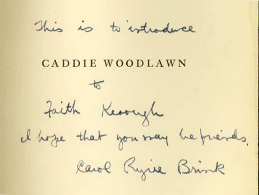
    <summary type="html"><![CDATA[<p><strong><em><span style="font-weight:400;">As an only child in rural Idaho Carol found amusement in her grandmother’s stories of an adventurous childhood in a homestead bustling with children and mischief. Later in life Carol would immortalize her grandmother through the titular character in the beloved children’s novel </span><i><span style="font-weight:400;">Caddie Woodlawn. </span></i></em></strong></p><img src="https://www.intermountainhistories.org/files/fullsize/0410429e7156474d165a3e74fc36171e.jpg" alt="Cover page of Caddie Woodlawn signed by author Carol Ryrie Brink" /><br/><p><span style="font-weight:400;">In 1895 Carol Ryrie Brink was born “Caroline Sybil Ryrie” in Moscow, Idaho. Her father died when she only five-years-old and her mother, stricken with grief and depression, died by suicide four years later. Orphaned, Brink went to live with her widowed grandmother “Gram” and an unmarried aunt who raised her for the remainder of her childhood.</span>
<span style="font-weight:400;"></span><span style="font-weight:400;">In her youth Brink’s favorite activity was listening to Gram's tales of mischief and adventure growing up with six siblings on the Wisconsin frontier. Such a large family was a novelty to Brink, who had no siblings and had only the company of her guardians. She described Gram as “a naturally gifted storyteller” who did not feel “at home with pen and paper.” Of </span><i><span style="font-weight:400;">Caddie Woodlawn</span></i><span style="font-weight:400;">, Brink remarked, “The adventures of Caddie would probably have remained unwritten if I had not been a lonely little girl who adored stories.” </span>
<span style="font-weight:400;">While Brink eventually outgrew her loneliness, she never abandoned her passion for storytelling. In high school and throughout college she dedicated her talent to the school papers. She graduated from University of California, Berkeley in 1917 and was married the following summer Raymond W. Brink, an old friend she had met in Moscow nearly a decade prior. The Brinks had two children, David Ryrie and Nora Caroline, were raised on their mother’s stories and often spent their summers in the Wisconsin woods or the Scottish countryside. </span>
<span style="font-weight:400;"></span><span style="font-weight:400;">Brink wrote several manuscripts before she began the semi-biographical tale of </span><i><span style="font-weight:400;">Caddie Woodlawn</span></i><span style="font-weight:400;">. She dabbled in playwriting for a time, though she was primarily interested in writing novels, often for children. The collection of stories and characters who would eventually come to life in </span><i><span style="font-weight:400;">Caddie Woodlawn </span></i><span style="font-weight:400;">had been in the back of her mind since her childhood declaration, “When I grow up, I am going to write books.”</span><i></i><span style="font-weight:400;">The project took several years, as Brink wanted to make sure she got all of the historical and cultural details right and truly did it justice. </span>
<span style="font-weight:400;">The woman who inspired Caddie was eighty-two-years-old when the book was published in 1935. She was thrilled to read the story and astounded by her granddaughter’s memory, stating “there are things I told her when she was eight years old which are perfectly remembered!” </span>
<i><span style="font-weight:400;">Caddie Woodlawn </span></i><span style="font-weight:400;">received a Newbery Medal in 1936, beloved by both critics and children alike. Young girls living through the Great Depression found escape in the exciting tale of Caddie, just as Brink had during her gloomy childhood. </span></p><p><em><strong><a href="https://www.intermountainhistories.org/items/show/927">For more (including 3 images) view the original article</a></strong></em></p>]]></summary>
    <published>2025-12-09T17:24:31+00:00</published>
    <updated>2026-04-17T19:32:21+00:00</updated>
    <link rel="alternate" type="text/html" href="https://www.intermountainhistories.org/items/show/927"/>
    <id>https://www.intermountainhistories.org/items/show/927</id>
    <author>
      <name>Megan Bailey, Brigham Young University</name>
    </author>
  </entry>
  <entry>
    <title type="html"><![CDATA[The Big Stick: Teddy Roosevelt Speaks at Idaho University: Story 7 of 8 of the President Theodore Roosevelt in the West Tour]]></title>
    <summary type="html"><![CDATA[<p><strong><em>“Ex-President Theodore Roosevelt visits the University of Idaho to give a speech and plant a tree,” read an article from Moscow, Idaho’s Daily Argonaut in anticipation of his April 9, 1911, visit to town.</em></strong></p><img src="https://www.intermountainhistories.org/files/fullsize/c5ffffacc9410315cdef74f37b166af9.jpg" alt="Theodore Roosevelt address Idaho citizens atop a stack of wheat sacks. This is a nod to his time as a Rough Rider and agricultural advancements in Idaho" /><br/><p>Even though he had visited Idaho twice before, President Theodore Roosevelt’s spring 1911 visit to the state was no less elaborate and momentous. His escort through Moscow, Idaho, could barely get to his hotel as the streets were so packed full of excited spectators. After arriving at his hotel and indulging in an informal Sunday dinner with “a small party of political officials,” Roosevelt appeared grandly at the University of Idaho the following morning, April 9, 1911. From breakfast in Ridenbaugh Hall with about 80 of the school’s finest, “university faculty, several prominent citizens and government officials, and the presidents and secretaries of the various classes of the university” Roosevelt was “escorted by the Grand Army Corps, carrying the American flag, and by a company of the University cadets” and saluted by the students until he arrived in front of the administrative building. A crowd Roosevelt estimated to be about 20,000 gathered to hear his address.
The setup for Roosevelt’s speech was unusual. The Administration building’s front doors were stacked with what seemed to be sandbags but were in fact sacks of wheat. This was a nod to northern Idaho’s agricultural industry. It made for a striking image as the adventurous former president climbed and spoke from the top of the pile. His 45-minute speech urged Idaho to “follow the rest of the West in progressive legislation.” Roosevelt was preparing to run for his 3rd term as the Progressive Party (also nicknamed the Bull Moose Party) candidate. He continued that, “true government by the people once obtained and improperly used, would work out for us, not salvation, but damnation.” After concluding, the crowd witnessed Roosevelt planting a tree on the university’s lawn. Still standing today, with a placard label, Roosevelt’s Colorado Blue Spruce is a reminder of Roosevelt’s 1911 visit and his views on forestry, the outdoors, and conservation. Speech and tree-planting concluded, Roosevelt made his way to the train station and departed Moscow by 10:30 AM.
This particular visit to the University of Idaho made a special impact through symbolism and memorabilia. Reflecting on the University’s motto, “For the training of Idaho's future citizens to their highest usefulness in private life and public service” Roosevelt said he admired the ideals that were expressed and that “the pioneer spirit is still the proper spirit, but with it we must prepare to meet new conditions.” His tree planting stunt helped those present remember the importance of the conservation of natural resources. With its presence standing tall on campus today, it serves as a reminder for the current generations to be good farmers and good citizens.
 </p><p><em><strong><a href="https://www.intermountainhistories.org/items/show/920">For more (including 3 images) view the original article</a></strong></em></p>]]></summary>
    <published>2025-10-24T15:03:17+00:00</published>
    <updated>2026-08-18T15:51:59+00:00</updated>
    <link rel="alternate" type="text/html" href="https://www.intermountainhistories.org/items/show/920"/>
    <id>https://www.intermountainhistories.org/items/show/920</id>
    <author>
      <name>Jessika Cole, Brigham Young University</name>
    </author>
  </entry>
  <entry>
    <title type="html"><![CDATA[Bear Lake — Idaho-Utah]]></title>
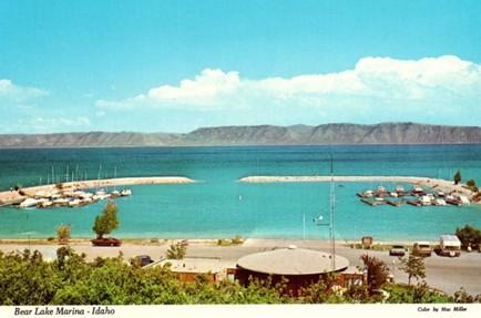
    <summary type="html"><![CDATA[<p><strong><em>Along Idaho’s forty-five-mile portion of Highway 89, travelers pass Bear Lake, a natural freshwater body that spans the Utah and Idaho state lines. The lake’s vibrant blue waters have attracted travelers and locals to enjoy its outdoor recreation opportunities since the arrival of Euro-American settlers. Regular visitors have referred to Bear Lake as the “Caribbean of the Rockies,” due to its bright blue color. </em></strong></p><img src="https://www.intermountainhistories.org/files/fullsize/a2052eb33acb8a79b958725076cfb96f.jpg" alt="Bear Lake Marina Idaho Vintage Postcard Collectible Scenic View" /><br/><p><span>Long before Euro-American settlers found Bear Lake, the Bannock, Shoshone, and Ute tribes frequented the surrounding landscape for hunting. U.S. military officers John Fremont and Benjamin Bonneville surveyed this area in 1842. Their findings paved the way for Oregon Trail travelers, who later traversed around the lake en route to Oregon. During the late 19th century, Bear Lake was an informal outdoor recreation site, attracting tourists from across the American West to enjoy boating, camping, fishing, hunting, and swimming at the lake’s bright blue waters. </span>
<span>Multiple ambitious locals recognized the site’s popularity and chose to open resorts with lodging and dining. By 1926, several private resorts operated on Bear Lake’s shores, including Bear Lake Hot Springs, Fish Haven, Ideal Beach, Lakota, and Logan Canyon. In the following decades, some of these facilities expanded to offer indoor entertainment, such as rollerskating at Lakota Resort and dancing at Fish Haven Resort. Alongside outdoor recreation, Bear Lake’s various resorts became popular sites for large gatherings like family reunions and school field trips. During the early-mid 20th century, the Bear Lake resorts received higher volumes of tourists between June and August, leaving their lodging facilities with no vacancies. The Bear Lake resorts would experience increased patronage following the extension of Highway 89 from St. Charles, Utah, to Paris, Idaho, in 1956. These businesses advertised the lake’s accessibility to Salt Lake City residents who could reach their summer getaway via the highway without being too far from home.</span>
<span>Recognizing the site’s popularity, the Utah Bureau of Land Management declared Utah’s portion of Bear Lake a state park in 1962 with plans to expand the marina and harbor that year. In 1963, the Idaho State Land Board designated the lake’s northern shore as a state park. It was not uncommon for travelers en route to Yellowstone National Park to stop and behold the unexpected beauty of Bear Lake. The site grew to such popularity in the 1970s that the two state parks closed temporarily and considered ways to control the expanding crowds. Members of the Bear Lake County Commission and the State Parks Commission in each state considered charging overnight campers additional fees, enforcing a maximum capacity, and enforcing boat speed limits. While the state park directors strove to allow the maximum number of visitors to enjoy the beaches, they agreed that certain regulations were necessary to promote a quality experience for all.</span>
<span>Bear Lake continues to be a popular outdoor tourist destination along Highway 89 throughout the year. Spring and summer visitors can enjoy biking, bird-watching, boating, camping, swimming, and water skiing, while winter visitors enjoy ice fishing for the native Bonneville Cisco whitefish. This unique fishing opportunity has made the lake a popular attraction for such an activity, especially when the fish spawn near the lake’s icy shores in late January each year. Even if highway travelers do not plan to stop at Bear Lake, its vibrant blue waters offer a uniquely scenic view as they cruise by on Highway 89.</span></p><p><em><strong><a href="https://www.intermountainhistories.org/items/show/910">For more (including 5 images) view the original article</a></strong></em></p>]]></summary>
    <published>2025-09-23T15:38:24+00:00</published>
    <updated>2026-04-17T19:32:21+00:00</updated>
    <link rel="alternate" type="text/html" href="https://www.intermountainhistories.org/items/show/910"/>
    <id>https://www.intermountainhistories.org/items/show/910</id>
    <author>
      <name>Alexandra Williams, Northern Arizona University</name>
    </author>
  </entry>
  <entry>
    <title type="html"><![CDATA[Sheep Eaters (Mountain Shoshones) in the Greater Yellowstone Ecosystem]]></title>
    <summary type="html"><![CDATA[<p><strong><em>The Sheep Eaters (also known as Mountain Shoshones, Tukudika, or Snake Indians), resided in Yellowstone National Park, the Wind River Mountains in Wyoming, and parts of central Idaho, until the reservation era.</p></strong></p><img src="https://www.intermountainhistories.org/files/fullsize/5a9a77ddc55c952bffe2d127a3c16817.jpg" alt="Tukudika (Sheepeater) men, women, and children at Medicine Lodge Creek, Idaho, in 1871." /><br/><p><span style="font-weight:400;">Much of the history of the Sheep Eaters emanates from archeological and ethnographic research. Many scholars believe their origins are in the Great Basin, though that continues to be debated. Trappers like Osborne Russell were among the first Euro-Americans to leave written accounts about the Sheep Eaters. Russell noted that a group of about 22 Sheep Eaters he met were “neatly clothed in dressed deer and Sheep skins of the best quality and seemed to be perfectly contented and happy … [They had] about 30 dogs on which they carried their skins, clothing, provisions etc on their hunting excursions. They were well armed with bows and arrows pointed with obsidian…” Early descriptions provide useful information, but they also often encouraged stereotypes. For example, Philetus Norris, Superintendent of Yellowstone National Park in 1877, described the Sheep Eaters as “vanished” and “hermits."</span>
<span style="font-weight:400;">The Sheep Eaters domesticated dogs they used to carry packs and pull travois. Their name came from their main source of food, Rocky Mountain Bighorn Sheep, which the dogs may have assisted in hunting. Pots and pipes carved from steatite represent another distinguishing characteristic of Sheep Eater culture.</span>
<span style="font-weight:400;">The Sheep Eaters participated in the Rocky Mountain fur trade from the 1820s through the 1850s. During the 1870s, the Lemhi Valley Agency was created to oversee the removal of the Sheep Eaters, Bannocks, and Shoshones to Lemhi Valley in central Idaho. In 1880, they began to be relocated to Fort Hall, but some Sheep Eaters remained in Yellowstone, eventually joining the Eastern Shoshones on the Wind River Reservation. Idaho censuses continued to list Sheep Eaters as a distinct group through the early part of the twentieth century.</span>
<span style="font-weight:400;">It is important to note that the Sheep Eaters did not “vanish” or go extinct as Norris and others described. </span><span style="font-weight:400;">Today, some of the Sheep Eater descendants live on the Wind River Reservation in Wyoming and the Fort Hall Reservation in Idaho. </span>
<span style="font-weight:400;">In 2023, the town of Jackson, Wyoming issued a land acknowledgement concerning the Sheep Eaters:</span>
<ul>
<li><em><span style="font-weight:400;">We recognize that the land we are gathering on is the ancestral homeland of the Mountain Shoshone People who stewarded it for thousands of years and that many other tribes also lived upon and cared for this area … With gratitude, we honor Indigenous peoples, past and present. We also acknowledge the sovereignty of the Native nations closest to Jackson whose land was taken through broken treaties that resulted in the creation of the Wind River and Fort Hall Indian Reservations. We recognize this acknowledgement is simply a first step. The Town of Jackson is committed to continued and informed action to connect with Indigenous people.</span></em></li>
</ul></p><p><em><strong><a href="https://www.intermountainhistories.org/items/show/887">For more (including 3 images) view the original article</a></strong></em></p>]]></summary>
    <published>2025-04-19T02:12:32+00:00</published>
    <updated>2026-04-17T19:32:20+00:00</updated>
    <link rel="alternate" type="text/html" href="https://www.intermountainhistories.org/items/show/887"/>
    <id>https://www.intermountainhistories.org/items/show/887</id>
    <author>
      <name>Emmaretta Barnett, Brigham Young University</name>
    </author>
  </entry>
  <entry>
    <title type="html"><![CDATA[Shoshone Falls: The Niagara of the West]]></title>
    <summary type="html"><![CDATA[<p><strong><em>If you are heading through Twin Falls, Idaho on Interstate 84, you’ll want to take a short detour on U.S. highway 93 to Shoshone Falls Park, located on the Snake River.</em></strong></p><img src="https://www.intermountainhistories.org/files/fullsize/82f0a7cd60a9208c11e4d9917e0e0bc2.jpg" alt="Thomas Moran, Shoshone Falls, 1900, oil, Gilcrease Museum, Tulsa, Oklahoma." /><br/><p>Before the days of irrigation water and hydroelectricity, Shoshone Falls was an amazing sight to behold, water plunging 212 feet over the rocks, with the roar of the falls heard up to ten miles away. The falls created an impassable barrier for the migrating steelhead and salmon returning from the Pacific Ocean to spawn. In the spring, Indigenous people living throughout the Snake River Plain formed small bands to capture fish from the river and it remained an important area for Natives to gather, fish, and trade.  Downstream, fish were plentiful and provided life-sustaining food and an important component of Shoshone culture and spirituality.   </p><p>Archaeologists insist Shoshone Falls was formed over 14,500 years ago when Lake Bonneville catastrophically flooded during the Pleistocene Ice Age. A traditional Shoshone-Bannock story denotes a different story explaining the cosmology of the Shoshone/Snake River. Ejuba, a coyote, went fishing in the country of Yellowstone. On his way home, the fish and the water in his lined basket became too heavy to carry and he tripped and spilled the contents. Although he tried several times to build various rocky dams to contain the spilled water, it continually rushed over and created several waterfalls. The river that Ejuba created is known today as the Snake River. The first dam he built was Idaho Falls, the second was American Falls, and the third dam split into two parts to become Twin Falls. The last and largest dam Ejuba constructed was Shoshone Falls. Another Shoshone tale describes a maiden distraught over the separation from her lover who hurled herself into the Snake River canyon at a point near the edge of the falls, a fenced off area known as “Lover’s Leap.”</p><p>Shoshone Falls has undergone tremendous changes. The once roaring waters that were heard from miles away now dwindle to a stream. The demand for water to irrigate the land and the desire for clean hydroelectricity dictates the amount of water that plunges over the falls. When visiting the falls on such a day it is hard to imagine that a writer once compared Shoshone Falls to Niagara Falls saying, “Surely there must be a God above. . .who made these Western Falls, which soon shall mock the magic art of Eastern ones and sink them into insignificance.” Visit the falls in the early Spring if you hope to catch a glimpse of its original majesty at maximum flow. </p><p><em><strong><a href="https://www.intermountainhistories.org/items/show/850">For more (including 2 images) view the original article</a></strong></em></p>]]></summary>
    <published>2024-09-24T18:23:02+00:00</published>
    <updated>2026-04-17T19:32:19+00:00</updated>
    <link rel="alternate" type="text/html" href="https://www.intermountainhistories.org/items/show/850"/>
    <id>https://www.intermountainhistories.org/items/show/850</id>
    <author>
      <name>Rochelle A. Hewett, Brigham Young University</name>
    </author>
  </entry>
  <entry>
    <title type="html"><![CDATA[Tree Spiking in Idaho&#039;s Clearwater National Forest, 1989 ]]></title>
    <summary type="html"><![CDATA[<p><strong><em><span style="font-weight:400;">In 1989, a group sought to sabotage a lumber sale by spiking trees in Idaho’s Clearwater National Forest. The incident led to decades of controversy for the environmentalist movement.</span></em></strong></p><img src="https://www.intermountainhistories.org/files/fullsize/04567ad38d5a1641ca7d1bf82bced03b.jpg" alt="Nail in a Tree" /><br/><p><span style="font-weight:400;">In March 1989, the U.S. Forest Service received a letter warning that trees in the Clearwater National Forest in Idaho had been spiked, claiming that nine people spent 11 days spiking trees with 500 pounds of nails. It mentioned that the land was important to the earth, and home to wildlife and the trees. The group signed the letter under the pseudonym “George Hayduke” in reference to a protagonist in Edward Abbey’s </span><i><span style="font-weight:400;">The Monkey Wrench Gang</span></i><span style="font-weight:400;">, followed by a threat that disregarding the message could result in a lot of people getting hurt. Investigations by the Forest Service revealed that 284 trees had been spiked with 384 nails. As a result, the Plum Creek Sawmill in Montana suffered damages when a saw exploded after hitting a spike.</span>
<span style="font-weight:400;">The perpetrators were a group associated with Earth First! who had first met in Missoula, Montana in 1988. They were protesting the Post Office Creek Timber sale, which opened a northeast parcel of Clearwater National Forest to logging operations. By spiking trees in the area, they hoped to preserve old growth in the forest. Earth First! founder Dave Foreman’s environmentalist guidebook </span><i><span style="font-weight:400;">Ecodefense</span></i><span style="font-weight:400;">, published in 1985, cites tree spiking as a viable tactic to disrupt logging and deforestation. The book includes a how-to section for tree spikers, as well as instructional diagrams. Spiking trees in a visible way was seen as an immediate deterrent for loggers, while concealing spikes could be effective in destroying equipment. By the 1990s, Earth First! literature no longer supported spiking due to both danger for humans and legal repercussions. </span>
<span style="font-weight:400;">The mailing of the letter led to FBI and Forest Service investigations into the Environmental Studies Department at the University of Montana. Agents raided student housing, collecting notebooks and calendars for evidence. The FBI subpoenaed seven Missoula residents to provide handwriting and hair samples for physical evidence before an Idaho grand jury. Investigators discovered that Tracy Stone-Manning, a University of Montana graduate student associated with the group, had rented a typewriter from the library to retype the letter then mailed the letter to the Forest Service. Stone-Manning, facing charges of conspiracy, received immunity in exchange for her testimony against other members of the group. In February 1993, a grand jury indicted Jeffrey Fairchild and John Blount in connection to the tree-spiking. A federal jury in Spokane, Washington convicted the men of conspiracy and depredation against property of the United States following a June 1993 trial. Blount was sentenced to 17 months in prison and ordered to pay restitution, while Fairchild received probation. </span>
<span style="font-weight:400;">The incident at Clearwater National Forest returned to the national spotlight in 2021 when President Joe Biden nominated Tracy Stone-Manning as director of the Bureau of Land Management. Her confirmation by the Senate Committee on Energy and Natural Resources was marked by discussions on ecoterrorism and participation in radical environmentalist groups. Despite the controversy around her involvement in the 1989 tree-spiking, the Senate Committee confirmed Stone-Manning as director of the BLM.</span></p><p><em><strong><a href="https://www.intermountainhistories.org/items/show/837">For more (including 4 images) view the original article</a></strong></em></p>]]></summary>
    <published>2024-05-29T18:55:12+00:00</published>
    <updated>2026-04-17T19:32:18+00:00</updated>
    <link rel="alternate" type="text/html" href="https://www.intermountainhistories.org/items/show/837"/>
    <id>https://www.intermountainhistories.org/items/show/837</id>
    <author>
      <name>Emily Roth, Northern Arizona University</name>
    </author>
  </entry>
  <entry>
    <title type="html"><![CDATA[North Beach at Bear Lake: The &quot;Caribbean of the Rockies&quot;]]></title>
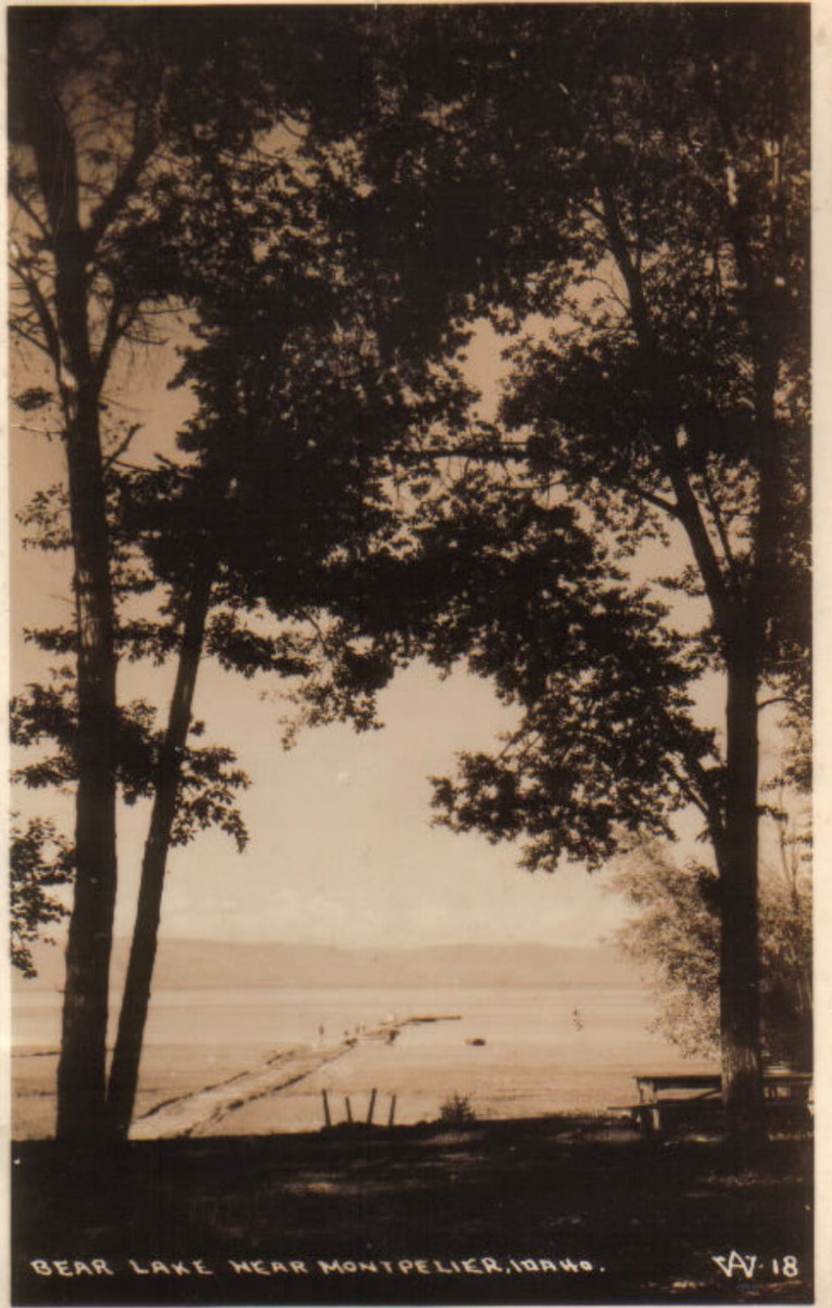
    <summary type="html"><![CDATA[<p><strong><em>Known as the "Caribbean of the Rockies," North Beach at Bear Lake is remembered for its clear, turquoise waters and the neighboring historical hot springs.</em></strong></p><img src="https://www.intermountainhistories.org/files/fullsize/10473506f86f1e2d1f5ca0c2d8a1af4f.jpg" alt="Bear Lake near Montpelier, Idaho. c. 1898" /><br/><p>The sandy shores of North Beach at Bear Lake meet the turquoise waters that inspired the nickname “Caribbean of the Rockies” and have made the beach a main tourist attraction at the Utah-Idaho border. North Beach sits on Idaho territory and provides activities such as boating, fishing, jet skiing, kayaking, picnicking, sunbathing, and swimming. Paired with these activities are the amenities, which include a boat launch ramp, grills, campgrounds, and picnic tables. In 2022 alone North Beach had over 300,000 visitors as it is a great place for families to come and wade in the shallow, warm waters.</p><p>Bear Lake has 12,000 years of Indigenous history as Native Americans would settle on the beach’s shores and use the waters for fishing and the surrounding areas for plant gathering and hunting. The native tribes that live near North Beach today are the Shoshone and Bannock tribes of southern Idaho. Following the Oregon Trail, Mormon settlers were the next prominent group to live in Bear Lake Valley. They negotiated with the Shoshone tribe for part of the land and established the community of Paris in 1863. Joseph C. Rich was an early pioneer at Bear Lake and married Ann Eliza Hunter. Together they developed the make-shift hot springs at North Beach in 1888 that used an underground pipeline to bring the hot water from the springs to the bathing pools.</p><p>Decades later in 1911, Ethel Bates became the owner of the Grand Hotel built next to the hot springs bath. The hotel became a well-known place to enjoy the scenic views of Bear Lake and allowed visitors to have multiple days at the beach. In 1939, the hotel burned down, leaving only a few pillars and stairs people can visit today. Ruth and Lorenzo Hemmert bought the property in 1950 to rebuild the lodging amenities and renovate the hot spring pools. They owned the property until 2018 when it sold to a land developer who plans to tear down the existing buildings to make room for a subdivision called Lakeview.</p><p>After years of rising popularity, in the late 1960s and early 1970s, there was much conversation about expanding the facilities because of overcrowding. In 1969 the Idaho State Journal noted that about 3,500 persons visited North Beach daily during peak summer days. Construction occurred during the early 1970s and included new campgrounds, restrooms, picnic facilities, and access to running water to mitigate overcrowding and improve sanitation.</p><p>The popularity of North Beach still reigns true and visitors must reserve a spot on the beach, up to one day in advance. Bear Lake and especially North Beach have also been the victim of drought over the past years. Bear Lake Idaho’s brochure notes the “low water levels” and how public use and the exposed lake bed have “created a concern for the lake’s environment and safe recreation use.” Respecting the beach is crucial for a future of sunbathing, swimming, and other beach activities at the “Caribbean of the Rockies.”</p><p><em><strong><a href="https://www.intermountainhistories.org/items/show/828">For more (including 5 images) view the original article</a></strong></em></p>]]></summary>
    <published>2024-05-23T01:05:00+00:00</published>
    <updated>2026-04-17T19:32:18+00:00</updated>
    <link rel="alternate" type="text/html" href="https://www.intermountainhistories.org/items/show/828"/>
    <id>https://www.intermountainhistories.org/items/show/828</id>
    <author>
      <name>Olivia Hall, Northern Arizona University</name>
    </author>
  </entry>
  <entry>
    <title type="html"><![CDATA[Stillinger Herbarium]]></title>
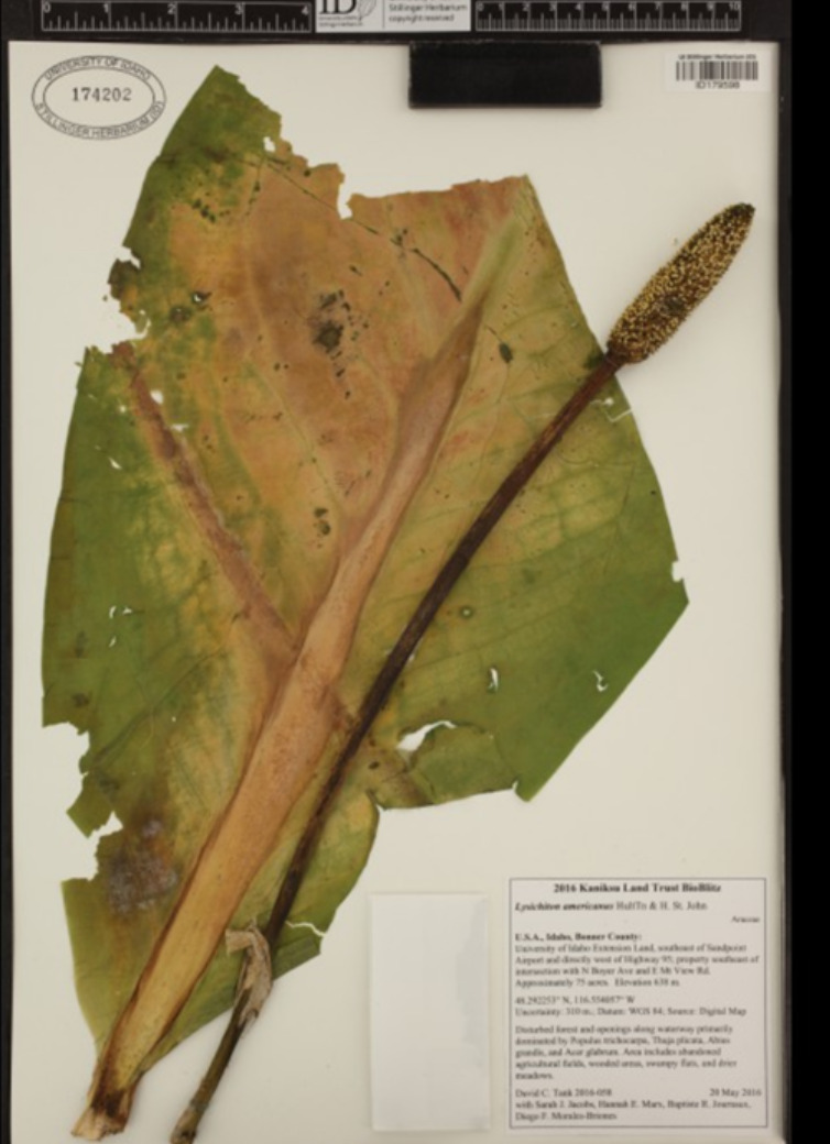
    <summary type="html"><![CDATA[<p><strong><em>Louis F. Henderson established The Stillinger Herbarium at the University of Idaho when he became the school's first botanist. Then, a fire destroyed half of the herbarium collection and slowed the institution's growth. Despite this setback, the herbarium recovered and continued to thrive, becoming the largest herbarium in Idaho and the seventh largest in the Pacific Northwest.</em></strong></p><img src="https://www.intermountainhistories.org/files/fullsize/9963e7472cf392bb249fbc1e385bb4eb.jpg" alt="Lysichiton americanus, also known as a Western Skunk Cabbage" /><br/><p><span style="font-weight:400;">In 1893, the University of Idaho in Moscow hired Louis F. Henderson as its first botanist. Henderson gave the school a collection of local plants he gathered for personal study, and in 1893, it became the foundation of the herbarium. Henderson became the herbarium's first director and retired in 1906. During this time, Henderson accumulated over 10,000 specimens from various locations in Idaho, storing the herbarium archives in the University of Idaho Administration building. However, a fire destroyed 85,000 specimens from the herbarium collection and Henderson's files, such as notebooks and letters, when the Administration building burned down on March 30, 1906. After 1908, when Henderson retired as director, the herbarium's growth was gradual but not forgotten. Botanists William H. Baker and J.H. Christ continued their exploration of the local plants and were significant contributors to the regrowth of the herbarium. By the mid-1900s, the collection had increased to about 50,000 specimens. The herbarium received additional aid to its development when Charles Roy and Nettie May Stillinger created the Stillinger Trust in 1957. Charles was a former university student and afterward became a teacher in botany and science. Charles and his wife dedicated their trust to the University of Idaho, with most of its income to the school herbarium and twenty percent to the Nettie May Stillinger Memorial Scholarship Fund. Their trust funded the development of the herbarium collection for the past sixty-six years and continues to do so to this day.</p>The herbarium saw a range of new directors that aided the collection's growth—starting with Douglass M. Henderson. He was in charge from 1972 to 1996 and doubled the plant archives' size. However, after his sudden death in 1996, Dr. Pamela Brunsfeld took over in 2001 until 2008. Brunsfeld was an Instructor of Systematic Botany at the university. After the resignation of Brunsfeld, the current director, Dr. David Tank, began. Tank is a biologist and leads active collection-based research programs involving students, staff, and professional hobbyists to aid in the growth and development of the Stillinger Herbarium. Tank's program has led to the current collection of 215,000 specimens, making it a major resource for studying the plants of Idaho and the Pacific Northwest.</p><p><em><strong><a href="https://www.intermountainhistories.org/items/show/823">For more (including 4 images) view the original article</a></strong></em></p>]]></summary>
    <published>2024-05-22T18:57:14+00:00</published>
    <updated>2026-04-17T19:32:18+00:00</updated>
    <link rel="alternate" type="text/html" href="https://www.intermountainhistories.org/items/show/823"/>
    <id>https://www.intermountainhistories.org/items/show/823</id>
    <author>
      <name>Cristal A. DeSantiago, Northern Arizona University</name>
    </author>
  </entry>
  <entry>
    <title type="html"><![CDATA[The &quot;Ghost Streetcar&quot; of South Boise Station, Idaho]]></title>
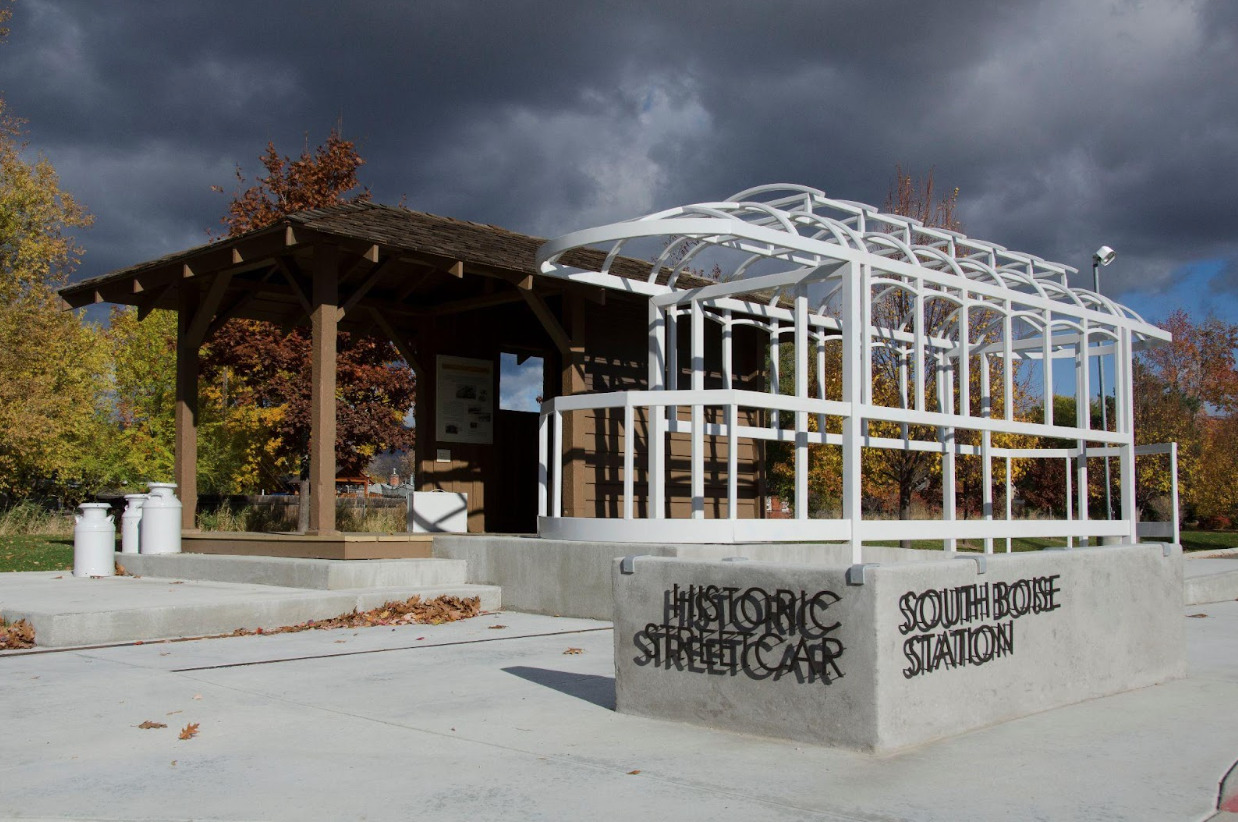
    <summary type="html"><![CDATA[<p><strong><em>Once a trolley shelter on the verge of demolition, the South Boise Streetcar Station features a “ghost streetcar,” a skeletal sculpture designed to commemorate Boise’s trolley history.</em></strong></p><img src="https://www.intermountainhistories.org/files/fullsize/0074d4188c04497c1d8f70aa728da031.jpg" alt="Historic South Boise Streetcar Station Plaza. 2013" /><br/><p><span style="font-weight:400;">Amidst the green grasses of Ivywild Park, a large recreational space in the southern end of Boise, Idaho, stands a bleached, skeletal phantom of a trolley car. This “ghost streetcar” is a to-scale installation sculpture designed by the Byron Folwell firm in 2012, and it features prominently as part of Ivywild Park’s South Boise Trolley Station Plaza, a refurbished trolley shelter that stands as one of the only remnants of the Boise Interurban.</span>
<span style="font-weight:400;">Boise’s streetcar history began in 1891, a year after Idaho achieved statehood, when the Boise City Rapid Transit Company opened an electric rail line along Main Street. From there, Boise’s streetcar network underwent enormous growth; as new communities sprang up, a slew of private companies sought to build more lines and provide service to neighborhoods across the rapidly developing city. The exponential growth of Boise’s communities was intricately intertwined with the proliferation of the streetcar, an early example of what planners now call “transit-oriented development.”</span>
<span style="font-weight:400;">Individual trolleys served communities throughout the Treasure Valley, including Boise and Caldwell, but there was a growing desire among Valley residents and investors alike to connect these disparate streetcar systems into one interurban network. The effort to create an interurban loop from these piecemeal trolleys began with Walter E. Pierce’s Boise Interurban Railway, which initiated construction of a link northward from Boise and Caldwell in 1905, with service beginning in 1907. Meanwhile, Donald Ustick and Robert Noble’s Boise Valley Railway extended southward to Nampa. The northern and southern interurban lines remained disconnected until 1912, when the Idaho Railway Light & Power Company purchased both companies and completed the Boise Valley Interurban Loop, operating streetcars along it as the Idaho Traction Company. Nearby hydroelectric dams supplied much of the power to this new interconnected trolley system.</span>
<span style="font-weight:400;">A wide variety of people relied on the Interurban’s service for their needs, from students riding to the College of Idaho campus in Caldwell to farmers taking their produce to railroad stations. At its peak in 1920, the trolley cars had carried over two and a half million passengers. The trolley had been so foundational to building community in the Valley that local community boosters nicknamed the region’s semi-professional intercity baseball club the “Trolley League.” Despite this, however, the growing popularity of automobiles heralded the end of the Boise streetcar’s profitability. Gradually, buses replaced trolley lines, and the Idaho Power Company ceased all streetcar service from Boise to nearby cities in May of 1928.</span>
<span style="font-weight:400;">The trolley shelter that had once housed streetcars in South Boise remained untouched for almost a century, the city letting it fall into disrepair and dilapidation. The shelter faced the prospect of demolition until 2012,  when three Boise city organizations - the Southeast Boise Neighborhood Association, the City of Boise Department of Arts & History, and the Boise Department of Parks and Recreation - endeavored to save the location from its grim fate. Employing the Byron Folwell design firm to create a life-size skeletal sculpture of a streetcar, the three organizations revitalized the shelter as a public historical attraction and community art piece, a monument to the streetcar history of Boise.</span></p><p><em><strong><a href="https://www.intermountainhistories.org/items/show/818">For more (including 4 images) view the original article</a></strong></em></p>]]></summary>
    <published>2024-05-21T05:33:45+00:00</published>
    <updated>2026-04-17T19:32:18+00:00</updated>
    <link rel="alternate" type="text/html" href="https://www.intermountainhistories.org/items/show/818"/>
    <id>https://www.intermountainhistories.org/items/show/818</id>
    <author>
      <name>Liam Craddock, Northern Arizona University </name>
    </author>
  </entry>
  <entry>
    <title type="html"><![CDATA[The Yankee Fork Mining District]]></title>
    <summary type="html"><![CDATA[<p><strong><em><span style="font-weight:400;">Custer County, Idaho is home to one of the best preserved gold dredges in the country–and a rich mining history that ushered in new life and opportunity. </span></em></strong></p><img src="https://www.intermountainhistories.org/files/fullsize/f3100d51405a82a8c2925197e302b71a.jpg" alt="Yankee Fork Gold Dredge" /><br/><p><span style="font-weight:400;">Placer gold, extractable by hand with little equipment, was discovered in Idaho in 1860 by E. D. Pierce. Pierce became fixated with the idea of mining on the Nez Perce territory in Northern Idaho and corners of Washington and Oregon. He eventually disregarded the law which prohibited mining on Native American lands and chose to proceed with his plans, launching the region into a new era of exploration, excavation, and the boomtowns that sprouted up in response.</span>
<span style="font-weight:400;">Previous to the discovery of gold, settlements in the region were largely made up of various Christian missionary enterprises and Mormon communities. Congregationalist-Presbyterians and Catholics were among the first to travel to Idaho in the 1830s, introducing christianity to the Nez Perce and establishing settlements in the area. Groups of Mormon settlers traveled north from the Salt Lake Valley into what would become Idaho, first in 1855, and progressively more in the following years. </span>
<span style="font-weight:400;">Idaho became a U.S. territory in 1863, and there was growing interest in the land for more than just religious reasons. As gold speculators made their way through the territory they found vast riches around Yankee Fork, a river in central Idaho’s Custer County. It wasn’t long until a mining district–a section of rural land designated for mining–was established around the river. By 1882, annual gold and silver production in Idaho had reached 3.5 million dollars, and one-third of that profit came from placer deposits in the rivers of Custer County. Additionally, there was an abundance of ore, another source of wealth for hardrock mining in Idaho. However, many of these spoils were in the riverbed which made them difficult to extract without the proper equipment. </span>
<span style="font-weight:400;">The Yankee Fork Mining District is most famous for its dredge, designed to extract gold and silver from riverbeds. The use of industrial machines, rather than physical labor, was first introduced in the late nineteenth century–but it wasn’t until 1940 that the construction of the Yankee Fork Gold Dredge was complete. It was no small enterprise at 112.5 feet long and 64 feet high, with a bucket system and sluice boxes to collect and sift through elements. Even though mining stopped during World War II due to the nationwide ban on non-essential mining, work at the dredge picked up again in 1946. The second stint didn’t last long; the dredge was shut down for good in 1952 when the once abundant minerals ran dry. Although it operated for less than ten years, the Yankee Fork dredge managed to produce over 1 million dollars. Today it is a site for summer tourists and one of the best preserved dredges in the U.S. Although a relic of the past, Custer County is still host to 952 mines for the extraction of silver, gold, lead, zinc, and copper.  </span></p><p><em><strong><a href="https://www.intermountainhistories.org/items/show/804">For more (including 5 images) view the original article</a></strong></em></p>]]></summary>
    <published>2024-05-16T01:28:14+00:00</published>
    <updated>2026-04-17T19:32:17+00:00</updated>
    <link rel="alternate" type="text/html" href="https://www.intermountainhistories.org/items/show/804"/>
    <id>https://www.intermountainhistories.org/items/show/804</id>
    <author>
      <name>Megan Bailey, Brigham Young University</name>
    </author>
  </entry>
  <entry>
    <title type="html"><![CDATA[City National Bank of Boise]]></title>
    <summary type="html"><![CDATA[<p><strong><em>Opened in 1886, the Boise City National Bank quickly became one of the largest financial houses in Idaho and the Pacific Northwest, operating for a total of forty-six years.</em></strong></p><img src="https://www.intermountainhistories.org/files/fullsize/b717659bdc02604d2951ecfeaba1dac4.jpg" alt="Boise City National Bank" /><br/><p><span style="font-weight:400;">In 1886 Boise had a single national bank and Idaho’s growing mining and agricultural production offered conditions for another financial house. Alfred Eoff, a freelance economic agent operating across the American West since the 1860s, took advantage of this opportunity. Encouraged by Wells Fargo & Company treasurer Henry Wadsworth to seize the opportunity, Eoff established Boise City National Bank in 1886. Situated near Main Street and Capitol Boulevard, it was established as a competitor to the First National Bank of Idaho. Wadsworth acted as City National’s president while Eoff became its cashier, becoming part of Wells Fargo’s growing presence in the American West.</span>
<span style="font-weight:400;">Wadsworth’s recommendations proved sound. By 1890, City National Bank’s portfolio included over $620,000 in financial assets, with $65,000 held in securities alone. Idaho’s population boom increased City National’s business, requiring a larger building as the initial bank became too small to house its customers and resources, including cash, deeds, or precious metals. This led City National Bank’s board to construct a three-story building designed by local architect James King that could house both the bank and rentable commercial and office space. This new structure housed not only the bank but also the United States Marshals’ and Surveyor’s Offices as well as Idaho’s federal district court after its completion in 1892.</span>
<span style="font-weight:400;">Despite the 1890s economic downturn, City National’s portfolio continually increased, with total assets totaling $870,000 by 1900. Continued growth led to the addition of a fourth story commercial club in 1904 and renovations in 1913, all designed by John Tourtellotte & Company who also planned Idaho’s State Capitol. The commercial club catered to its patrons, who likely consisted of influential stockmen, farmers, and investors, offering amenities such as a dining district, billiards parlor, cardroom, lounge, writing room, and a library. </span>
<span style="font-weight:400;">By 1905, Wadsworth retired and Frank R. Coffin became City National’s new president. Coffin, previously lured west from Indiana, first settled in California as a tinsmith and later became a gold miner in Idaho’s 1860 gold strike. He served as Idaho’s first state treasurer from 1891-93, treasurer of the Artesian Hot and Cold Power Company, one of the state's leading utility corporations, and president of the Boise Clearinghouse Association, a local financial institution. Serving as president until he died in 1920, Coffin further expanded City National’s reach until it became Idaho's second-largest national bank, with $1.6 million in total assets.</span>
<span style="font-weight:400;">By 1932, during the strain of the Great Depression, City National voluntarily closed, citing depleted reserves. It argued that closure was the best option for depositors, with the remaining $2.5 million in accounts distributed among its clients. After its closure, various owners occupied the bank building, including the Idaho Building and Loan Association and the J. R. Simplot Company, one of Idaho’s largest corporations. Today it is owned by Rocky Mountain Management, and houses many offices and commercial businesses.</span></p><p><em><strong><a href="https://www.intermountainhistories.org/items/show/796">For more (including 7 images) view the original article</a></strong></em></p>]]></summary>
    <published>2024-03-20T19:44:45+00:00</published>
    <updated>2026-04-17T19:32:17+00:00</updated>
    <link rel="alternate" type="text/html" href="https://www.intermountainhistories.org/items/show/796"/>
    <id>https://www.intermountainhistories.org/items/show/796</id>
    <author>
      <name>William R. Batson, Northern Arizona University</name>
    </author>
  </entry>
  <entry>
    <title type="html"><![CDATA[John Jarvie’s Historic Ranch]]></title>
    <summary type="html"><![CDATA[<p><strong><em>Not all hospitality is returned in kind. In the case of John Jarvie, the outlaws to whom he was so obliging went on to rob and murder both him and his son. </p></strong></p><img src="https://www.intermountainhistories.org/files/fullsize/fa571c3f7ee8336879f9a9d505c7f737.jpg" alt="John Jarvie" /><br/><p><span style="font-weight:400;">In 1880 John Jarvie and his wife Nellie Barr moved from Rock Springs, Wyoming to the burgeoning settlement of Brown’s Park. Jarvie set up a general store, post office, and ran a river ferry that crossed the nearby Green River. Jarvie became well known for his sagacity and kindness to all those who lived in the region, even the Wild Bunch outlaws. Such associations did not serve him well in the long run, but his kindness did, and his legacy has continued to today in Uintah and Daggett County.</span>
<span style="font-weight:400;">John Jarvie was born in Scotland in 1844. As a young man after being beaten soundly by a mine supervisor, Jarvie elected to immigrate to the United States as a stowaway. He arrived in America in 1870 and settled in Rock Springs, Wyoming.  After several years as a businessman in Rock Springs, working as a Saloon Owner, Jarvie met residency requirements and became a citizen on October 8</span><span style="font-weight:400;">th</span><span style="font-weight:400;">, 1875. In 1880 at the age of 36, Jarvie married Nellie Barr, 22, and the couple moved to Brown’s Park, the present location of John Jarvie’s Historic Ranch.  Jarvie opened a general store, moved the local post office to his property, and ran a ferry that crossed the Green River.</span>
<span style="font-weight:400;">Jarvie sold to everyone in the region, even notorious outlaws. One location on the historic ranch in particular, a storage cellar, was thought to have housed criminals like Butch Cassidy when they were on the run from the law. One notable event on the Ranch in 1895 termed the “Outlaws’ Thanksgiving Dinner” saw a dinner of gratitude  between several notorious outlaws including Billie Bender, Les Megs, Butch Cassidy, Elza Lay, Isom Dart, and the Sundance Kid. The meeting was jovial and in celebration of Jarvie and other residents in Brown’s Park tolerance of the outlaw’s activities. In light of their warm relationship, it is tragic that Jarvie and one of his sons eventually lost their lives to outlaws.</span>
<span style="font-weight:400;">William King and George Hood, hearing false rumors about Jarvie’s great wealth, came to the ranch on July 6</span><span style="font-weight:400;">th</span><span style="font-weight:400;">, 1909. Jarvie was alone, his sons having taken jobs on other farms, and his wife having died of Tuberculosis in 1895. Jarvie was known for his generosity and tendency to feed visitors so he set the table for three. The outlaws did not return his kindness. They forced Jarvie to open his store safe and took the contents, a $100 bill and a pearl handled revolver. Jarvie fled the store and was shot in the back and head. The outlaws placed his body on a boat and sent it down the river. Details of the murder slowly tricked out. When reports circulated of two men trying to change a $100 bill in Rock Springs, Jarvie’s son Jimmy pursued the outlaws voraciously. Jimmy was on their trail at an Inn in Idaho when he was pushed from a second-floor balcony and fell to his death. The criminals were never apprehended.</span>
<span style="font-weight:400;">Jarvie left a powerful legacy which was seen in the obituary written for him in the Vernal Express. There he was praised as a “the sage of the Uintahs, the Genius of Brown’s Park, and the Wizzard [sic] of the hills and rivers. He was not only a man among men but he was a friend among men… He was as broad and generous and far reaching in his good deeds as the stream which he knew and loved[.]”</span></p><p><em><strong><a href="https://www.intermountainhistories.org/items/show/770">For more (including 3 images) view the original article</a></strong></em></p>]]></summary>
    <published>2024-01-20T08:08:00+00:00</published>
    <updated>2026-04-17T19:32:17+00:00</updated>
    <link rel="alternate" type="text/html" href="https://www.intermountainhistories.org/items/show/770"/>
    <id>https://www.intermountainhistories.org/items/show/770</id>
    <author>
      <name>Samuel Pulsipher, Brigham Young University</name>
    </author>
  </entry>
  <entry>
    <title type="html"><![CDATA[Chinden Boulevard: Remembering Chinese Contributions to Boise]]></title>
    <summary type="html"><![CDATA[<p><strong><em>Many residents of Idaho’s capital know the name “Boise” comes from the French word for “wooded,” but will those who call “The City of Trees” home recognize another familiar name in the valley that recalls Idaho’s storied past as a culturally diverse frontier territory?</p></strong></p><img src="https://www.intermountainhistories.org/files/fullsize/a9f4450a4cbf7c33cbfa46eac170c193.jpg" alt="A Festival on Chinden" /><br/><p><span style="font-weight:400;">“Chinden Boulevard,” or US Highway 20/26 is a vital East-West artery of the Boise metropolitan area which connects suburban homes to the workplaces, restaurants, and entertainment centers of the capital city’s quaint downtown. Many commuters on this road, or those pleasure-seekers out for a night on the town, are, perhaps, unaware that the road’s name bears the memory of the Chinese immigrants who came to the region decades before Idaho achieved statehood. Instead of the tattoo parlors and used car lots lining the road today, near the end of the 19th century, the road passed acres of beautiful vegetable gardens planted and cared for by Chinese immigrants, thus earning the name “China-garden,” or “Chinden.”</span>
<span style="font-weight:400;">The discovery of gold in Southern Idaho in 1862 marked the beginning of a mass migration into the region that extended over the course of multiple decades and paved the way to statehood. Though united in their search for fortune and opportunity, the early prospectors and adventurers who braved this new frontier came from diverse cultural and ethnic backgrounds. One early resident of Idaho expressed his first impression of Boise in these words: “In the courtyard of the Overland Hotel I saw, the morning of my arrival in Boise, an Irishman, a Spaniard, a Frenchman, two Chinamen, a Canadian, an Englishman—and not an American.”</span>
<span style="font-weight:400;">Early Idaho was diverse and one prominent group in the cultural patchwork of the region was Chinese immigrants. In fact, in a population of about 20,600 in the territory of Idaho in 1869, 4,274 were Chinese. Though many Chinese came to the region in search of gold, over time they took up other pursuits. Indeed, it could be said that in the Idaho Gold Rush the Chinese abided by the idiom, “during a gold rush, sell shovels.” Instead of mining, many began shop keeping, cleaning laundry, raising pigs, and growing and selling vegetables to mining communities. Initially, the produce from these Chinese gardens was intended for Chinese miners, but—due to the quality and availability of the vegetables—the market quickly expanded outside Chinese circles to entire communities. The produce attracted such praise that one newspaper commented that, “most of their productions surpass in size and excellence the imported articles.” With Boise as the main supply center of the region and many Chinese looking to sell their goods and services to miner customers, many Chinese gravitated to the city, becoming a crucial part of both the city and territorial economy. In 1871, a newspaper noted that “The China population are planting gardens here pretty extensively. They are so patient and puttering that they do well.” These “patient and puttering” gardeners were known to group together to lease land for their various crops. Each took part in planting, harvesting, and selling their produce.</span>
<span style="font-weight:400;">During the growing season, work in the fields would begin before dawn. By sun-up, their carts would be loaded and ready for making deliveries to homes or selling vegetables in the streets. Another newspaper report illustrates a typical interaction between a Chinese vegetable peddler and their client: “John Chinaman makes his appearance at our door bright and early every morning, with the traditional pole and baskets, the latter filled with every variety of fresh plucked and cool vegetables.” Clearly, the Chinese presence in Boise was prominent as they filled a variety of needs for a variety of customers on a regular basis.</span>
<span style="font-weight:400;">While newspapers at times praised the industry of Chinese workers, their often patronizing tone is indicative of both the underlying and overt racism and persecution the Chinese in Idaho endured. Indeed, as far removed as the territory was, it was not far enough to escape the waves of anti-Asian legislation that spread in the wake of the Chinese Exclusion Act of 1882. After only a few decades, many Chinese left Idaho, and the once vibrant Chinese community became a shadow of what it once was. Today, Chinden Boulevard still passes through Garden City, the lowlands west of Boise’s downtown where scores of Chinese immigrants cultivated gardens to build themselves better lives. Though their exodus out of Idaho left a vacancy in Boise’s Chinese population that has not been filled since, the memory of their resolve in the face of adversity can continue to inspire generations of Idahoans as they travel along the old China-gardens road.</span></p><p><em><strong><a href="https://www.intermountainhistories.org/items/show/739">For more (including 3 images) view the original article</a></strong></em></p>]]></summary>
    <published>2023-04-07T18:08:21+00:00</published>
    <updated>2026-04-17T19:32:16+00:00</updated>
    <link rel="alternate" type="text/html" href="https://www.intermountainhistories.org/items/show/739"/>
    <id>https://www.intermountainhistories.org/items/show/739</id>
    <author>
      <name>Jacob Johnson, Brigham Young University</name>
    </author>
  </entry>
  <entry>
    <title type="html"><![CDATA[The Struggle to Colonize the Frozen Tundra of Paris, Idaho]]></title>
    <summary type="html"><![CDATA[<p><strong><em>Many marked Paris, Idaho as inhospitable. The colonists lacked the manpower to easily sustain a colony and confronted harsh conditions that tested their mettle.</em></strong></p><img src="https://www.intermountainhistories.org/files/fullsize/2ba942fad0298e6f105cdfae2568a1b3.jpg" alt="A Sunny Day in Paris" /><br/><p><span style="font-weight:400;">Charles C. Rich and his family settled Paris, Idaho on September 26, 1863. Rich served as an Apostle for The Church of Jesus Christ of Latter-Day Saints under the prophet Brigham Young. Young sent Rich and his family to settle the area and establish a colony of members of The Church of Jesus Christ of Latter-day Saints. Even today, Paris, located near Bear Lake, is notorious for its cold winters and mild summers. </span>
<span style="font-weight:400;">Rich and his family succeeded in establishing a colony despite the difficulties presented by the climate and location of Paris. The winters were terrible in Paris and challenged the colonists each year with life-threatening cold. The climate also complicated agriculture and made it difficult for Paris’s early settlers to make it a sustainable place to live. Originally, Brigham Young and the colonists of Paris thought they were in Utah. But that changed when Rich tried to run for a Utah government position, and they discovered Paris was in Idaho.</span>
<span style="font-weight:400;">In 1884, early Paris residents began building a meetinghouse for the church members to worship in. They worked to quarry sandstone from a location over 20 miles away from the construction site. The harsh climate worked to their advantage in the winter, enabling them to reduce the travel time by several miles by transporting the stone over the frozen Bear lake. Today, the tabernacle is listed on the National Register of Historic Places and is open to visitation by the public.</span>
<span style="font-weight:400;">The tabernacle in Paris is one of its most visited and iconic attractions that the town has to offer. The original Mormon settlers in Paris endured the climate and their perseverance proved to be worth it. Not only did the original settlers survive, but the original buildings have persevered as well.</span></p><p><em><strong><a href="https://www.intermountainhistories.org/items/show/736">For more (including 3 images) view the original article</a></strong></em></p>]]></summary>
    <published>2023-04-06T17:09:05+00:00</published>
    <updated>2026-04-17T19:32:16+00:00</updated>
    <link rel="alternate" type="text/html" href="https://www.intermountainhistories.org/items/show/736"/>
    <id>https://www.intermountainhistories.org/items/show/736</id>
    <author>
      <name>Trevor Rich, Brigham Young University </name>
    </author>
  </entry>
  <entry>
    <title type="html"><![CDATA[The Old Idaho State Penitentiary]]></title>
    <summary type="html"><![CDATA[<p><strong><em>The Old Idaho Penitentiary operated for over 100 years as the first prison in Boise, Idaho. Over the years it has housed over 13,000 inmates, hosted 36 wardens, and was the site of numerous escapes, riots, and executions. Today, it stands as one of only four territorial prisons open to the public and has been converted to a museum detailing the prison’s history.</em></strong></p><img src="https://www.intermountainhistories.org/files/fullsize/a2d30f007de6a7615d40500011f92655.jpg" alt="Women&#039;s Ward" /><br/><p><span style="font-weight:400;">Located between the heart of downtown Boise and the Boise Foothills, the Old Idaho Penitentiary serves as a reminder of Idaho’s territorial past. Inmates quarried the distinctive sandstone that makes up the prison’s buildings and walls from the nearby Table Rock area, a well-known Boise landmark. The penitentiary first opened in 1872 and was originally known as the Territorial Prison. It was later renamed the Idaho State Penitentiary when Idaho achieved statehood in 1890.</span>
<span style="font-weight:400;">The prison was constructed in the Second Empire architectural style with guard turrets and thick walls reminiscent of a castle or fortress. Architects intended the construction to evoke a “somber, dark environment deemed appropriate for prisoners.” Wardens and guards encouraged inmates to work to reduce idleness and the penitentiary became almost entirely self-sufficient. Inmate labor carried the added benefit of reducing construction fees, costs, and wages significantly, saving the state hundreds of thousands of dollars. However, the prison lacked modern amenities, a problem that would cause discontent and riots in later years.</span>
<span style="font-weight:400;">As the number of inmates increased, the compound expanded significantly. The inmates quarried sandstone and constructed most of the buildings themselves. By 1973, the penitentiary’s walls had housed multiple cell blocks, several administrative buildings, the warden’s house, a dining hall, library, commissary, blacksmith and carpenter shop, shirt and license plate factory, women’s ward, an apiary, a garden, and a steam plant. The prison also contained several isolation and punishment cells, known as the “Dungeon,” “Cooler,” and “Siberia,” as well as a gallows that was used to execute ten prisoners. Additionally, the penitentiary owned several ranches and farms that utilized inmate labor to produce the prison’s food.</span>
<span style="font-weight:400;">Harry Orchard was the penitentiary’s most infamous prisoner. He had assassinated Frank Steunenberg, the former governor of Idaho, with a bomb as revenge for the government’s role in the 1890 mining conflicts in Coeur d'Alene. Although he confessed to killing at least 17 men, Orchard remained a model prisoner. Other prisoners were not, and the penitentiary experienced over 500 escape attempts. Prisoners escaped by running away from work assignments, digging tunnels, climbing walls, or lowering themselves down makeshift ropes. Some succeeded, but the majority were caught soon after their escape. </span>
<span style="font-weight:400;">There were also several riots in the later years of the penitentiary's history, reflecting inmate discontent with outdated prison conditions. One of the most notable riots occurred in 1952, when nearly 250 inmates seized the Multipurpose Building and severely damaged it. In 1971, two prisoners were stabbed, inmates set fire to several buildings, and others raided the commissary and hospital. A similar riot occurred in 1973 and caused significant fire damage. </span><span style="font-weight:400;">The riots were all put down, some using tear gas, but the increasing frequency worried prison officials. </span>
<span style="font-weight:400;">The riots, outdated facilities, and lack of space for expansion led to the construction of a new correctional facility in 1972. This facility was built near Kuna, Idaho, and officials gradually transferred inmates there. By 1974, the recently renamed Old Idaho Penitentiary earned a spot in the National Register of Historic Places. Today, it has been converted into a museum run by the Idaho State Historical Society. Boise residents refer to it as the “Old Pen,” and local legend claims it is haunted by the ghosts of former guards and executed inmates.</span></p><p><em><strong><a href="https://www.intermountainhistories.org/items/show/734">For more (including 6 images) view the original article</a></strong></em></p>]]></summary>
    <published>2023-04-05T20:08:12+00:00</published>
    <updated>2026-04-17T19:32:16+00:00</updated>
    <link rel="alternate" type="text/html" href="https://www.intermountainhistories.org/items/show/734"/>
    <id>https://www.intermountainhistories.org/items/show/734</id>
    <author>
      <name>Madison Sommer, Brigham Young University</name>
    </author>
  </entry>
  <entry>
    <title type="html"><![CDATA[The Pierce City Massacre: Violence Against Immigration Laborers]]></title>
    <summary type="html"><![CDATA[<p><strong><em>In 1885, one of Pierce, Idaho’s most popular residents was brutally murdered, and five Chinese men were charged with the crime. Furious about the murder, a group of vigilantes took custody of the Chinese men and lynched them a few miles outside of town.</em></strong></p><img src="https://www.intermountainhistories.org/files/fullsize/ef6d8ea863046d1bc8793f88bf3fb5bb.jpg" alt="Pierce, Idaho" /><br/><p><span style="font-weight:400;"> Pierce was a mining town located in northern Idaho that came to be dominated by a large Chinese population in 1885. Though the Chinese were legally banned from mining in Idaho when Pierce was settled, they were eventually given the right to mine if they paid a $4 monthly tax to the county government. With this adjustment, many Chinese migrated to the area. However, like in other western cities, Chinese presence was not particularly welcome, as others worried that their jobs would be taken by Chinese laborers who were willing to work for less money. They also saw the Chinese as dirty and incapable of assimilation. </span>
<span style="font-weight:400;">In 1885, an American merchant named D.M. Fraser was murdered, supposedly by a competing Chinese merchant, Lee Kee Nam. Fraser was a prominent man in the community, and the town was horrified and outraged when they found his body, which had been cut into pieces, in his own store. A group of vengeful vigilantes assembled, and they captured Lee Kee Nam and his business partner. The vigilantes threatened to hang the two men which led Lee Kee Nam and his partner to incriminate one another. After this, they rounded up three more Chinese men, who the mob claimed had actually committed the crime, and turned all five men over to the sheriff. The group was charged for Fraser’s murder and sent to trial. </span>
<span style="font-weight:400;">However, the five men were not given the chance to appear in court. While the sheriff and some of his men were transporting Lee Kee Nam and the other men to the court in the nearby town of Murray on September 18, 1885, they were confronted by a large group of armed men just a few miles outside of Pierce. The men overtook the sheriff’s posse, took the five Chinese men into custody, and lynched them. According to a newspaper report from the next day, a reporter “found the five Chinamen hanging by the necks on a pole lashed to two pine trees.” </span>
<span style="font-weight:400;">The Chinese government found the lynchings extremely upsetting and demanded reparations. The new territorial governor, Edward A. Stevenson, went to investigate the events, and it was found that Lee Kee Nam and his associate really had committed the crime. He used this as an excuse for the vigilantes’ behavior, and no one involved in the mob was ever prosecuted for their involvement. Stevenson did, however, urge Idahoans to stop harassing the Chinese, and there were few anti-Chinese incidents in Idaho following this lynching. </span></p><p><em><strong><a href="https://www.intermountainhistories.org/items/show/724">For more (including 6 images) view the original article</a></strong></em></p>]]></summary>
    <published>2023-03-06T18:24:51+00:00</published>
    <updated>2026-04-17T19:32:16+00:00</updated>
    <link rel="alternate" type="text/html" href="https://www.intermountainhistories.org/items/show/724"/>
    <id>https://www.intermountainhistories.org/items/show/724</id>
    <author>
      <name>Sydney Wilson, Brigham Young University</name>
    </author>
  </entry>
  <entry>
    <title type="html"><![CDATA[Ahavath Beth Israel in Boise, Idaho]]></title>
    <summary type="html"><![CDATA[<p><strong><em>Ahavath Beth Israel (Hebrew for "Love of the House of Israel") is the oldest synagogue in continuous use west of the Mississippi River. Founded in part by the first Jewish governor in United States history, it represents over 125 years of Jewish life in Idaho. </em></strong></p><img src="https://www.intermountainhistories.org/files/fullsize/47a512e31e6ea673617a2392d1569f9c.jpg" alt="Temple Beth Israel" /><br/><p><span style="font-weight:400;">Among the first immigrants to Idaho were Jews who came from Germany and Central Europe beginning in the 1860s. They arrived soon after Congress declared Idaho a territory and primarily worked in mercantile or farming operations. They worshipped in private homes and rented halls until they amassed the resources for a synagogue. In 1895, five years after statehood, community leaders organized an official congregation and elected successful Boise merchants Moses Alexander and David Falk as leaders. They led the congregation to purchase three lots a few blocks from the state capitol and hired an architectural firm to begin construction on the Temple Beth Israel. Records later surfaced that nationally known companies such as Marshall Field and Levi Strauss contributed to its construction. </span>
<span style="font-weight:400;">Local architects Chestney and Schroeder completed the synagogue in 1896, and its architecture reflects Rundbogenstil and Moorish Revival styles. Rundbogenstil was popular in Germany and its diaspora, reflecting the recent waves of German immigration. It incorporates Byzantine, Romanesque, and Renaissance styles commonly used in synagogue architecture of this period. It can be seen in the tall, arched window framing the synagogue, and the arched windows along the sides. Such windows, intricate detailing, and interior vaulted arches also reflect Moorish Revival style, a mainstay of nineteenth-century synagogues due to its association with Judaism’s Middle Eastern origins. The architects designed Temple Beth Israel with a white and reddish pink Boise sandstone base and cedar-shingled exterior that imitates stonework. They used Cathedral glass to make stained glass windows and adorned the building with a handmade Star of David. Its crowning feature is a large, circular rose window. Ornate yet small, the Boise congregation constructed it to hold only 150 people. </span>
<span style="font-weight:400;">The synagogue founders were major figures in Boise life. David Falk, the congregation president, owned dry goods stores and assisted in establishing the Boise-Winnemucca Railroad. Moses Alexander, vice president, became a prominent statesman. His fellow citizens elected him mayor of Boise in 1897 and 1901, and then governor of Idaho in 1914, becoming the first practicing Jewish governor in the United States. The community remained small throughout the twentieth century. In 1972, the Jewish citizenry successfully petitioned to have the synagogue placed on the National Register of Historic Places. A federal grant and other raised monies then facilitated a building renovation in 1981, which restored the windows, siding, and handmade Star of David—which they delayed placement of until an Aryan Nations Conference had left the area. Soon after, a new congregation of Jews who had moved from Poland after World War II merged with Temple Beth Israel, formally becoming Congregation Ahavath Beth Israel in 1986.</span>
<span style="font-weight:400;">The new congregation continued to grow, and, in 1994, added Daniel Fink as Idaho’s first full-time rabbi. They also needed more space, so they hired Cole & Associates to relocate the building in October of 2003. Of the additions, they added an education building. Today, the synagogue continues to support Boise’s Jewish population from its location on Latah Street. </span></p><p><em><strong><a href="https://www.intermountainhistories.org/items/show/718">For more (including 5 images) view the original article</a></strong></em></p>]]></summary>
    <published>2023-03-01T19:42:44+00:00</published>
    <updated>2026-04-17T19:32:15+00:00</updated>
    <link rel="alternate" type="text/html" href="https://www.intermountainhistories.org/items/show/718"/>
    <id>https://www.intermountainhistories.org/items/show/718</id>
    <author>
      <name>Katie Scholler, Northern Arizona University </name>
    </author>
  </entry>
  <entry>
    <title type="html"><![CDATA[The Arrival Celebration and The Round-Up Murals: Blackfoot, Idaho]]></title>
    <summary type="html"><![CDATA[<p><strong><em>Andrew Standing Soldier completed the expansive Blackfoot Main Post Office murals in 1939 at the age of twenty-two. Covering nearly every office wall, the murals depict scenes of the Shoshone-Bannock peoples and their lives in Idaho’s Eastern Snake River Plain.  </em></strong></p><img src="https://www.intermountainhistories.org/files/fullsize/b132395541509c3a7b7c56f12a0d2633.jpg" alt="Post Office Mural" /><br/><p><p style="font-weight:400;">Andrew Standing Soldier, a Sioux artist of the Oglala Lakota Nation, completed <em>the </em><em>Arrival Celebration</em> and <em>The Round-Up</em> when he was twenty-two, installing the murals in Blackfoot, Idaho’s Main Post Office. Gilbert Stanley Underwood constructed the Blackfoot MPO in 1936 in the Art Deco style, seen specifically through details such as the foliage motif that decorates the building’s exterior columns. When researchers placed the building onto the National Register of Historic Places in 1989, it was the sole federally-constructed post office in Idaho built in the Art Deco style. The building continues to operate as a post office today.
<p style="font-weight:400;">Andrew Standing Soldier was born in 1917 on South Dakota’s Pine Ridge Reservation. He was taught to draw by his father, Martin Standing Soldier. During the 1930s, he studied art under the Swedish muralist Olle Nordmark, a Pine Ridge artist-in-residence who was known for his mural work in New York. Nordmark went on to supervise Standing Soldier during the creation of the MPO murals. With his individualistic, western-focused style and well-drawn horses, Standing Soldier painted the post office murals through a government commission after he submitted sketches of his ideas.
<p style="font-weight:400;">Standing Soldier painted the five-panel <em>Arrival Celebration</em> and <em>Round-Up</em> with a realistic and Regionalist style under the Treasury Section of Fine Arts (TSFA), as a part of a six-mural project in Idaho funded by New Deal-era projects. The works cover all of the post office’s walls excluding the front wall and contains scenes based on life sketches depicting the everyday life of the Shoshone-Bannock peoples who live on the Fort Hall, Idaho, reservation. Their ancestral lands make up present day Idaho, Montana, Nevada, Oregon, Utah, Wyoming, and parts of Canada.
<p style="font-weight:400;"><em>The Arrival Celebration</em> and <em>The Round-Up</em> depict the western life of the Shoshone-Bannock peoples as they go about their day. In the background, he painted the distinct scenery of the vast Eastern Snake River Plain and the feeding ground that it provided for cattle. Along the mural’s wide expanse, the artist included scenes such as families travelling with horse-drawn wagons, people conversing on horseback, preparing covered wagons, cutting wood, and making meals with cattle roaming in the background. Standing Soldier also filled the scene with depictions of the traditional tipi dwellings of the tribes. <em>The Round-Up</em> portion of the mural shows a group of people as they work to rope and brand cattle.
<p style="font-weight:400;">His murals reflect the aims of the Treasury Section of Fine Arts in employing artists as well as establishing a western identity in art that everyday people could see for free in their day-to-day lives as they ran errands at the post office. Indeed, most New Deal-funded murals did not portray the Great Depression’s troubles, but rather displayed regional scenes of optimistic imagery and scenes of conviviality like the group cooking scene portrayed in Standing Soldier’s work.

</p><p><em><strong><a href="https://www.intermountainhistories.org/items/show/715">For more (including 4 images) view the original article</a></strong></em></p>]]></summary>
    <published>2023-02-27T23:04:14+00:00</published>
    <updated>2026-04-17T19:32:15+00:00</updated>
    <link rel="alternate" type="text/html" href="https://www.intermountainhistories.org/items/show/715"/>
    <id>https://www.intermountainhistories.org/items/show/715</id>
    <author>
      <name>Lindsey Cillis, Northern Arizona University </name>
    </author>
  </entry>
  <entry>
    <title type="html"><![CDATA[Aryan Nations Compound]]></title>
    <summary type="html"><![CDATA[<p><strong><em><span style="font-weight:400;">Aryan Nations was a community founded in 1973 by White nationalist, Richard Butler, to serve as the nucleus of an Aryan (White) homeland in northern Idaho. It closed in 2000 due to a court judgment after members assaulted two local Native American people.</span></em></strong></p><img src="https://www.intermountainhistories.org/files/fullsize/ccbe800e83299d88222551b757292630.jpg" alt="The Founder" /><br/><p><span style="font-weight:400;">Aryan Nations was a White-nationalist community founded on the Christian Identity movement which was based on the belief that people of Northern European ancestry are the true descendants of the ancient Israelites. The most prominent early figure in the movement was California minister Wesley A. Swift (1913-1970), who added the belief that people of color are subhuman and that Jews are descendants of Satan with inordinate power who want to destroy the White race. </span>
<span style="font-weight:400;">Richard Girnt Butler (1918-2004) was an aeronautical engineer who was inspired by the caste system while working in India during WWII and hoped to import the idea to the United States. Later, while living in California, he began to attend Swift’s sermons and became active in the church, eventually taking over as leader upon Swift’s death in 1970. In 1973, he moved his congregation to a twenty-acre property near the town of Hayden Lake, Idaho, hoping that it would be the nucleus of a future “Aryan homeland” in the northwestern states.</span>
<span style="font-weight:400;">Some parishioners moved with Butler from California to Idaho, and he used various recruiting methods to enlarge the congregation, including offering land to local struggling farmers and conducting prison outreach. He constructed a bunkhouse where formerly incarcerated men could live in exchange for printing and distributing his literature, and a watchtower with armed guards after an unknown person bombed his church.</span>
<span style="font-weight:400;">Only four people lived permanently on the grounds, but there were normally other residents staying there for periods of time ranging from months to years, and people living outside of the compound attended regular Sunday services, Bible studies, and holiday celebrations. Members were expected to abstain from alcohol, drugs, swearing, and extra-marital sex. There were numerous collective projects such as home-schooling residents’ children, operating the printing press, and administering the prison ministry.</span>
<span style="font-weight:400;">Over the next few decades, the Aryan Nations compound served as a gathering place for the White-supremacist movement, as exemplified by the annual Aryan Youth Festival and the Aryan World Congress, attended by hundreds of members of various White-supremacist groups, such as the KKK, neo-Nazis, and skinheads throughout the 1980s. Butler referred to it as the “international headquarters of the White race.” </span>
<span style="font-weight:400;">In the early 1980s the organization received public attention because of a series of bank robberies and a murder committed by a splinter group. The organization also faced increased resistance from locals in Cœur d’Alene; Kootenai County established a task force for human rights and residents would often protest the group’s activities.</span>
<span style="font-weight:400;">Aryan Nations was deteriorating by the late 1990s, however it met with a sudden, dramatic dénouement.  On July 1, 1998, two security guards assaulted Victoria Keenan, a local Native American woman, and her son on the road outside the compound. In a 2000 verdict, a district court found the organization negligent in the management of the guards and required it to pay $6.3 million to the victims. Butler declared bankruptcy and the compound was awarded to the Keenans. After leadership disputes following Butler’s death in 2004, Aryan Nations splintered into various factions.</span></p><p><em><strong><a href="https://www.intermountainhistories.org/items/show/706">For more (including 4 images) view the original article</a></strong></em></p>]]></summary>
    <published>2023-02-22T03:23:02+00:00</published>
    <updated>2026-04-17T19:32:15+00:00</updated>
    <link rel="alternate" type="text/html" href="https://www.intermountainhistories.org/items/show/706"/>
    <id>https://www.intermountainhistories.org/items/show/706</id>
    <author>
      <name>Evan Železny-Green, Northern Arizona University</name>
    </author>
  </entry>
  <entry>
    <title type="html"><![CDATA[Lake Lowell: Transforming Treasure Valley]]></title>
    <summary type="html"><![CDATA[<p><strong><em>The Reclamation Act of June 17, 1902, aimed to create proper irrigation systems that could provide water access for residents of western states. Lake Lowell was one of those projects.</em></strong></p><img src="https://www.intermountainhistories.org/files/fullsize/8dafc9cce562e3302960bcf13f35ebe2.jpg" alt="Building up" /><br/><p>Under the direction of the 1902 Reclamation Act—congressional legislation intended to irrigate western states and provide greater access to water—the Bureau of Reclamation approved and developed Lake Lowell, starting in 1902 and finishing in 1909. Three dams—the Upper, Middle, and Lower Embankments (embankments are walls of earth or stone built to prevent a river from flooding an area)—surround a natural depression southwest of Nampa, Idaho to form the lake. A fourth wall, called the East Embankment, was added later to protect farmsteads on the eastern end of the reservoir.
In the irrigation off-season, the Boise River Diversion Dam and New York Canal provide most of Lake Lowell’s volume, discharging water intp the upper end of the lake, where there is a capacity ranging from 12.7 feet on the Middle Embankment to 65 feet on the Upper. During the irrigation season, Lake Lowell becomes one of the major irrigation providers for Canyon County agriculture. With the capacity to irrigate over 200,000 acres of land, it is one of the American West’s largest off-stream reservoirs.
As with many other western irrigation projects, Lake Lowell presented a significant opportunity for economic growth and restructured the relationship between people and their environment. Along with other government investment projects that opened the area to construction and farming, irrigation attracted migrants from the Midwest who worked as laborers to develop the dam and as farmers to till the land. In 1900, the census counted 161,772 people living in Idaho; by the 1920 census, the population had more than doubled to 431,866 people. This growth was sharpest in southwestern Idaho, which grew by 130% during this twenty-year period as agricultural and ex-urban communities transformed Treasure Valley into fertile land. Lake Lowell made that change possible.
In addition to serving local farms, towns, and cities, Lake Lowell also plays a role in how people and other living things interact with the region’s nature. The lake hosts the Deer Flat Reservoir, one of the oldest refuges in the National Wildlife Refuge System. As for humans in nature, Lake Lowell is a popular destination for numerous outdoor activities, including boating, swimming, fishing, birdwatching, hiking, and hunting.</p><p><em><strong><a href="https://www.intermountainhistories.org/items/show/629">For more (including 5 images) view the original article</a></strong></em></p>]]></summary>
    <published>2022-06-30T21:27:42+00:00</published>
    <updated>2026-04-17T19:32:13+00:00</updated>
    <link rel="alternate" type="text/html" href="https://www.intermountainhistories.org/items/show/629"/>
    <id>https://www.intermountainhistories.org/items/show/629</id>
    <author>
      <name>Legna Roximar Morales, College of Idaho</name>
    </author>
  </entry>
  <entry>
    <title type="html"><![CDATA[Idaho’s Territorial Capital Dispute]]></title>
    <summary type="html"><![CDATA[<p><strong><em>Lewiston was Idaho's first territorial capital, but the title was short-lived. Many disputes over moving the capital down to Boise ensued between the people of Lewiston and the people of Boise, contributing to a longstanding divide between northern and southern Idaho.</em></strong></p><img src="https://www.intermountainhistories.org/files/fullsize/acc53b1a3c757d53c6ac8a90857a5ee8.jpg" alt="First" /><br/><p>A nineteenth-century dispute over where to place the state capital dispute helped create a regional divide that persists in Idaho to this day. It all started when westward settlers found gold in 1860, leading many to migrate to the Rocky Mountains in hopes of striking it rich. Settlers found gold in the Clearwater River, in northern Idaho, and some formed mining camps, one of which was Lewiston. As the settler population grew, many in the area called for establishing a seat of United States government closer than Olympia, Washington. In response, in March 1863, territorial governor William H. Wallace pronounced Lewiston the capital of Idaho. Wallace chose this location because in addition to the gold, there was already an established transportation and communication system that linked northern Idaho to other U.S. states and territories.
After the discovery of gold in 1862 in the Boise Basin, however, eager settlers rushed to the southern part of the territory. At the same time, gold had depleted up north in Lewiston, even further accelerating the southward migration. With most of the settler population now residing in the south, moving the capital seemed logical, especially since mountainous terrain made traveling between Boise and Lewiston difficult.
This turned out to be easier said than done, however. The territorial legislature, primarily made up of representatives from northern Idaho, failed the first initiative to change Idaho’s capital. However, in 1864 Idaho’s number of legislative representatives changed to accommodate the difference in population, leaving three representatives for the north and four for the south. This change in political power—plus pressure from H. C. Riggs, one of Bosise’s founders—convinced acting governor Caleb Lyon to move the capital to Boise. On November 23, 1864, Riggs introduced a bill to make Boise the capital. It passed six days later, and Lyon signed it into law.
Rather than fix the problem, this may have only made it worse. Governor Lyon fled to nearby Walla Walla, Washington, and sent a trusted official to retrieve the official documents from the acting secretary of Lewiston. After a stalemate over who had rights to the papers, and where the capital would officially reside, President Lincoln’s territorial secretary C. DeWitt Smith went to serve as acting governor of Idaho. With help from Fort Lapwai soldiers, Smith obtained the documents and traveled to Boise, where he put the new law into effect.
In the end, moving the capitol from Lewiston to southern Idaho left its residents with a sense of lost pride. This sparked a cultural divide between northern and southern Idaho that continues to this day. To this day, downtown Lewiston hosts a sign proclaiming the city “Idaho's First Territorial Capital,” demonstrating that the residents remember their city’s history and will not let people forget Idaho’s original territorial capital.</p><p><em><strong><a href="https://www.intermountainhistories.org/items/show/628">For more (including 3 images) view the original article</a></strong></em></p>]]></summary>
    <published>2022-06-30T20:51:21+00:00</published>
    <updated>2026-04-17T19:32:13+00:00</updated>
    <link rel="alternate" type="text/html" href="https://www.intermountainhistories.org/items/show/628"/>
    <id>https://www.intermountainhistories.org/items/show/628</id>
    <author>
      <name>Dawson Packwood, College of Idaho</name>
    </author>
  </entry>
  <entry>
    <title type="html"><![CDATA[Hells Canyon Dam]]></title>
    <summary type="html"><![CDATA[<p><strong><em>Straddling the Idaho–Oregon border and holding firm to the walls of Hells Canyon, the Hells Canyon Dam provides hydroelectric power and irrigation channels to surrounding localities. A creation of the Idaho Power Company, the concrete dam is one of three in the Hells Canyon Complex, the largest privately-owned hydroelectric power complex in the nation, whose motivations and consequences can be felt politically and ecologically.</em></strong></p><img src="https://www.intermountainhistories.org/files/fullsize/010642938f4450485d7ddd6aff0409f0.jpg" alt="Damming Hells Canyon" /><br/><p>The Hells Canyon Complex was controversial before even being built, ever since the Idaho public scrutinized the Idaho Power Company’s request to license three dams on the Snake River in 1947. During the New Deal era, public power—a method of energy administration defined in which communities owned infrastructure under local government—was the norm for hydroelectricity; while Idaho Power wanted to privately run three dams, advocates for public power in the region instead contended against Idaho Power in favor of establishing a single, high dam. After a long battle, private power won when the Federal Power Commission issued Idaho Power a license in 1955, allowing them to build a private hydroelectric complex, in turn signaling a decline of public power’s favor nationwide. Due to the Hells Canyon dam construction in the deepest gorge on the North American continent, the construction process proved difficult, and builders had to dig a twenty-three-mile access road into the Idaho side of the canyon. Along with the road, contractors set up offices, facilities, housing, and a mess hall for construction workers. In a matter of six months, the Hells Canyon Dam’s construction was complete in 1967, and it began generating electricity shortly after.
The political controversy in the postwar years about whether hydropower was something to be publicly or privately owned has roots deep in the ecological. The Hells Canyon Complex sits on the Snake River Basin, a desert ecosystem, while many of the models that public ownership advocates used were based on dams built on the Columbia River Basin, which was forested and mountainous. Because of the ecological differences inherent to these basins, people interacted differently with these water systems, and as a result, their priorities varied in what services a dam should provide. In the Columbia Basin, priority was given to energy production, while in the Snake Basin, priority was given to irrigation. This is largely due to the relationship people had with the land. In the Snake Basin, people cultivated the land for crop harvest, so they wanted the Hells Canyon Complex to have irrigation as its chief operating principle. This gave wind to Idaho Power’s licensing for the three Snake River dams; a single high dam would better serve power generation, but Idaho Power contended that the three-dam complex better served irrigation.
While ecology shaped Hells Canyon Dam, the dam also reshaped the environment. By its very design, the Hells Canyon Complex has no passage for andronomous fish species, a type of fish that migrates from freshwater to the ocean in the Snake and Columbia Rivers. Limiting certain fish species’ ability to access any of the upper Snake River Basin between the complex to Shoshone Falls has dramatically reduced the species’ population and disturbed several ecosystems. This can be traced back to the general neglect of biological research before the construction of dams along the Columbia and Snake Rivers.</p><p><em><strong><a href="https://www.intermountainhistories.org/items/show/627">For more (including 3 images) view the original article</a></strong></em></p>]]></summary>
    <published>2022-06-30T19:53:46+00:00</published>
    <updated>2026-04-17T19:32:13+00:00</updated>
    <link rel="alternate" type="text/html" href="https://www.intermountainhistories.org/items/show/627"/>
    <id>https://www.intermountainhistories.org/items/show/627</id>
    <author>
      <name>Hunter Marang, College of Idaho</name>
    </author>
  </entry>
  <entry>
    <title type="html"><![CDATA[Long Valley Finnish Church]]></title>
    <summary type="html"><![CDATA[<p><strong><em>The Long Valley Finnish Church was a crucial meeting place for Finnish Lutherans. The building continues to serve and educate the people of the area to this day.</em></strong></p><img src="https://www.intermountainhistories.org/files/fullsize/fe4390b086e8d75b5c5f75d81466c973.jpg" alt="Lasting legacy" /><br/><p><span>Following decades of struggle for independence from the Russian government and its anti-Finnish policies, numerous Finns left their homeland to migrate to the United States in search of religious and political freedom. Between 1900 and 1930, about 85 Finnish families traveled to Idaho and settled in Long Valley, southwest of Clear Creek and southeast of Hurday Creek. The Long Valley Finnish settlement became the largest Finnish community in the state of Idaho, centered around the Lutheran Church and celebrating Finnish culture. </span>
<span>These Finnish settlers took advantage of the 1862 Homestead Act, which allowed any adult citizen or intended citizen who had never fought against the United States government to claim 160 acres of land surveyed by the government. Contrary to popular perception, this land was not empty but had long been occupied by the Shoshone and Nimíipuu. The Homestead Act required the new property owners to live on and cultivate the land, leading most of the Long Valley Finns to become farmers or loggers.</span>
<span>The Lutheran Church was the foundation of the Long Valley Finnish community.  This community of worship established a physical location in 1917, when they built the Long Valley Finnish Church on an acre plot in Lake Fork, Idaho. The main hall of the church is forty-eight feet long and twenty-six feet wide, supplying ample space to worship and gather. The Long Valley Finnish Church was a cornerstone for the Finns as a place for the people to worship according to their Lutheran faith and come together as a community. People living in the area still use the chapel to this day for select worship services, funerals, and more.</span>
<span>Long Valley Finnish Church stands approximately 350 feet southwest of the Finnish cemetery where the majority of Finnish immigrants were laid to rest. Finnish Ladies Aid Society maintains and preserves the building, which today is one of the only remaining artifacts in Idaho representing the Finnish migration to the state.</span></p><p><em><strong><a href="https://www.intermountainhistories.org/items/show/626">For more (including 3 images) view the original article</a></strong></em></p>]]></summary>
    <published>2022-06-26T02:56:16+00:00</published>
    <updated>2026-04-17T19:32:13+00:00</updated>
    <link rel="alternate" type="text/html" href="https://www.intermountainhistories.org/items/show/626"/>
    <id>https://www.intermountainhistories.org/items/show/626</id>
    <author>
      <name>Cooper Leaf, College of Idaho</name>
    </author>
  </entry>
</feed>