<?xml version="1.0" encoding="UTF-8"?>
<feed xmlns="http://www.w3.org/2005/Atom">
  <title type="text">Intermountain Histories</title>
  <updated>2026-04-17T19:32:21+00:00</updated>
  <generator uri="http://framework.zend.com" version="1.12.20">Zend_Feed_Writer</generator>
  <link rel="alternate" type="text/html" href="https://www.intermountainhistories.org/"/>
  <link rel="self" type="application/atom+xml" href="https://www.intermountainhistories.org/items/browse?output=rss2"/>
  <id>https://www.intermountainhistories.org/</id>
  <author>
    <name>Intermountain Histories</name>
    <uri>https://www.intermountainhistories.org</uri>
  </author>
  <link rel="hub" href="https://pubsubhubbub.appspot.com/"/>
  <entry>
    <title type="html"><![CDATA[The Donners along the Humboldt River]]></title>
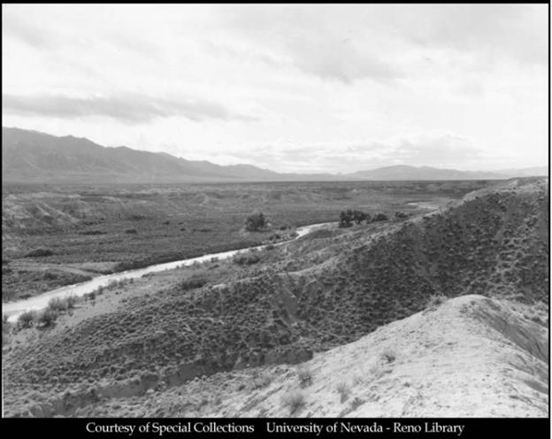
    <summary type="html"><![CDATA[<p><strong><em>The Humboldt River resides in modern-day central Nevada and marks the spot where the Hastings Cutoff reunites with the traditional California trail. It was along this river that distrust overcame the Donner Party, with its party members being attacked, banished, and murdered.</em></strong></p><img src="https://www.intermountainhistories.org/files/fullsize/cd9914b416dc039e95030e789f0a9067.jpg" alt="The Humboldt River" /><br/><p>The Humboldt River was named after German intellectual and explorer Alexander von Humboldt. His name can be found on things such as the Humboldt Ocean Current off the Western coast of South America and Humboldt County in present-day California. The river was used for centuries by Native Americans and became known to non-indigenous populations when Peter Ogden of the British owned Hudson’s Bay Company discovered it on one of his expeditions in 1829. Trappers and mountain men utilized it extensively, and it became a major navigational tool and watering spot for westward migrants in the 1840s. When the late-season and already weakened Donner Party reached the river in mid-September, 1846, drought had lowered the water level and withered adjacent greenery. Their travel along the Hastings Cutoff, which diverged south to skirt around the Ruby Mountains before returning north to the Humboldt River trail intersection, had added 100 miles to what they would have traveled had they stayed on the traditional trail.
Their troubles after the Great Salt Lake Desert were far from over. As they began their journey down the river, progress and supplies were stressed by Paiute depredations on their livestock. Then, on October 5th, as the Murphy family’s wagon led by teamster John Snyder attempted to pass James Reed’s wagon, the two trains became entangled and Snyder whipped Reed’s oxen in anger. Reed retaliated, and in the ensuing scuffle Snyder struck Reed’s wife and Reed stabbed Snyder, killing him. The Graves and Murphy families banished Reed from the group, sending him to the party’s desired destination of Sutter's Fort in California on his horse and promised to care for Mrs. Reed and their young children. Paiute altercations and interpersonal conflicts further escalated problems. An elderly Belgian emigrant, known only as Hardkoop, repeatedly went missing after being kicked out of Lewis Keseberg’s wagon.  An eyewitness said they had seen him sitting alone on the side of the trail unable to continue as <em>“his feet had swollen until the skin had split.”</em> William Eddy attempted to spend resources that night to find him, but was refused by other members of the party. As they progressed alongside the Humboldt River as many as 18 oxen were stolen, one wounded, and 21 killed by Paiutes. Making good progress regardless, they reached Humboldt Sink close to the end of the river, on October 13th. On this day a German emigrant, known only as Wolfinger, stayed behind with two other Germans to cache, or store, his wagon. The two Germans rejoined the party several days later, but Wolfinger was absent. The other Germans claimed Natives had killed him, but one later confessed to murdering Wolfinger, leaving his body to be devoured by vultures and coyotes in the Humboldt Sink.
The party reached the Truckee River which led up into the Sierra Nevada Mountains in eastern California, on the 16th of October. The roughly three week journey along the Humboldt River had strained their relationships and caused them to lose trust in each other. Hardkoop’s abandonment, Reed’s banishment, and Wolfinger’s murder reveal unraveling social cohesion. Losing Reed as a steady leader was especially damaging. The Humboldt served as a refuge from the Great Basin Desert for most emigrant groups heading towards California, but for the Donners it marked exponentially increasing troubles which would remain with them for the rest of their journey. The culmination of all their mistakes, from Forts Laramie and Bridger, the Wasatch Mountain range, the Great Salt Lake Desert, and the Humboldt River, would lead to great suffering for the party in the Sierra Nevadas.</p><p><em><strong><a href="https://www.intermountainhistories.org/items/show/934">For more (including 5 images) view the original article</a></strong></em></p>]]></summary>
    <published>2026-02-02T17:22:15+00:00</published>
    <updated>2026-04-17T19:32:21+00:00</updated>
    <link rel="alternate" type="text/html" href="https://www.intermountainhistories.org/items/show/934"/>
    <id>https://www.intermountainhistories.org/items/show/934</id>
    <author>
      <name>Samuel Watson, Brigham Young University</name>
    </author>
  </entry>
  <entry>
    <title type="html"><![CDATA[The Humboldt River and the Inevitable Railroad]]></title>
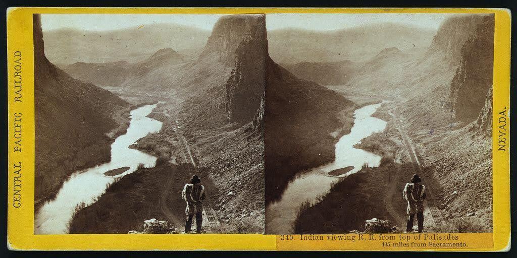
    <summary type="html"><![CDATA[<p><strong><em>Alfred A. Hart’s photo neatly captures the relationship that the United States had with Indigenous nations in the 19th century: persistent encroachment on and abuse of Native land. </em></strong></p><img src="https://www.intermountainhistories.org/files/fullsize/68061ca83529f9dba3c1da8a26419a79.jpg" alt="“Indian viewing railroad from top of Palisades. 435 miles from Sacramento.” " /><br/><p>Winding through the arid region of modern-day north central Nevada, the Humboldt River provided resources to support communities of a few hundred people. Punodungahnivain, or “Place where the house is” in Western Shoshone, was an area at the mouth of the South Fork River, between modern-day Carlin, Elko, and South Fork, that was home to Western Shoshone. </p><p>Water—and therefore the river—is sacred for the Western Shoshone, or “Newe” meaning “The People.” The Humboldt represents an important thoroughfare in ancient and modern trade routes, connecting goods from the Pacific with those in the Great Basin and western Rocky Mountains. The fertile river enabled Indigenous communities to thrive between modern-day Carlin and Elko. Roots and berries grew along the river, attracting birds and animals, and pine nut resources grew in the nearby Ruby mountains. The Shoshones hunted waterfowl, antelope, trout, gopher, rabbit, and beaver. </p><p>Trappers such as Peter Skene Ogden from the Hudson’s Bay Company arrived in the Humboldt region in the 1820s. They trapped as many beavers as possible in order to make it unprofitable for their competition, nearly wiping out the beaver population for a generation. After the discovery of gold at Sutter’s Mill in 1848, miners and settlers traveled along the Humboldt by the tens of thousands, negatively impacting the environment, depleting finite resources, and disrupting Indigenous lifeways. The California Trail transected Western Shoshone Territory throughout the 1840s through 1860s. Then, in the 1860s, the Central Pacific Railroad began building their Railroad from Sacramento, California, westward towards Utah Territory to join with the Union Pacific at Promontory Summit on May 10, 1869. </p><p>By the time CPRR worker Alfred A. Hart took the photo below, dated between 1865 and 1869, natural resources had already been depleted all along the Humboldt. Hart took hundreds of photographs as he traveled with the company, and many of them feature Shoshones. The completion of the railroad brought even more people west, who settled near the tracks in order to benefit from future commerce. These newcomers claimed the most fertile places for themselves and divided up ancestral Shoshone and Paiute lands. </p><p><em><strong><a href="https://www.intermountainhistories.org/items/show/851">For more (including 3 images) view the original article</a></strong></em></p>]]></summary>
    <published>2024-09-25T01:12:50+00:00</published>
    <updated>2026-04-17T19:32:19+00:00</updated>
    <link rel="alternate" type="text/html" href="https://www.intermountainhistories.org/items/show/851"/>
    <id>https://www.intermountainhistories.org/items/show/851</id>
    <author>
      <name>Ella Henricksen, Brigham Young University</name>
    </author>
  </entry>
</feed>