<?xml version="1.0" encoding="UTF-8"?>
<feed xmlns="http://www.w3.org/2005/Atom">
  <title type="text">Intermountain Histories</title>
  <updated>2026-04-17T19:32:20+00:00</updated>
  <generator uri="http://framework.zend.com" version="1.12.20">Zend_Feed_Writer</generator>
  <link rel="alternate" type="text/html" href="https://www.intermountainhistories.org/"/>
  <link rel="self" type="application/atom+xml" href="https://www.intermountainhistories.org/items/browse?output=rss2"/>
  <id>https://www.intermountainhistories.org/</id>
  <author>
    <name>Intermountain Histories</name>
    <uri>https://www.intermountainhistories.org</uri>
  </author>
  <link rel="hub" href="https://pubsubhubbub.appspot.com/"/>
  <entry>
    <title type="html"><![CDATA[Zitkala-Ša’s (Gertrude Simmons Bonnin) Sojourn in Utah<br />
]]></title>
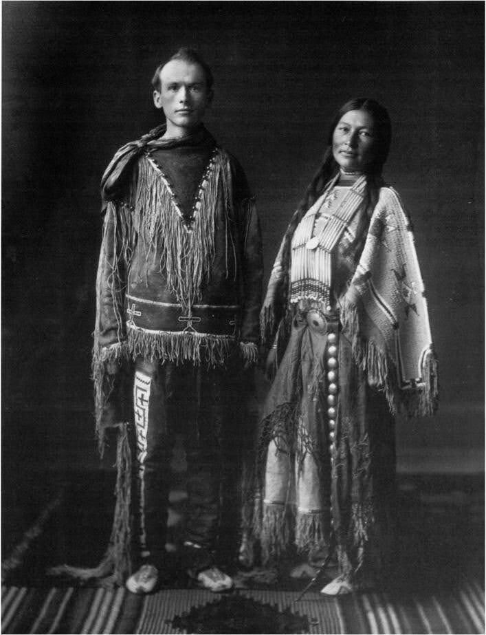
    <summary type="html"><![CDATA[<p><strong><em><span style="font-weight:400;">Zitkala-Ša, or Gertrude Simmons Bonnin, is a celebrated Yankton Dakota writer and activist. She lived in Utah from 1902-1917.</span></em></strong></p><img src="https://www.intermountainhistories.org/files/fullsize/45b71b8be1582e338eb8a6eee61bb4cc.jpg" alt="William F. Hanson and Zitkala-Ša" /><br/><p><span style="font-weight:400;">Born on the Yankton Sioux Reservation in South Dakota in 1876, Gertrude Simmons or Zitkala-Ša left the reservation at age eight to attend White’s Manual Labor Institute in Indiana. This assimilation-focused boarding school instilled Euro-American and Christian values in its students. She attended Earlham College and became an increasingly skilled writer and musician.</span> <span style="font-weight:400;">She taught at the Carlisle Indian Industrial School. After a while, she became critical of the emphasis on assimilation and acculturation and resigned. She began writing under the name Zitkala-Ša (Red Bird) around 1889, publishing essays in national magazines such as </span><i><span style="font-weight:400;">Harper’s Monthly</span></i><span style="font-weight:400;">. Her writings often criticized the practice of many reformers and stressed the importance of Native identities.</span>
<span style="font-weight:400;">Zitkala-Ša married Raymond Bonnin in 1902 and they moved to </span><span style="font-weight:400;">Whiterocks, Utah, where Raymond worked for the Indian Bureau on the Uintah and Ouray Reservation. In 1903, they had a son, Raymond “Ohiya” Bonnin. A young, orphaned Ute boy named Oran Curry and Old Sioux, a survivor of the Battle of the Little Bighorn, also lived with them. </span>
<span style="font-weight:400;">The Bonnins lived in Utah from 1902 to 1917, except for several months spent on the Standing Rock Reservation in the Dakotas. It was while away at Standing Rock that she converted to Catholicism. After returning to Utah, she kept up a correspondence with Father William Ketcham, director of the Bureau of Catholic Indian Missions, expressing her wish to introduce Catholicism to the Utes.</span>
<span style="font-weight:400;">In 1908, she met music teacher William Hanson</span><span style="font-weight:400;">. They eventually collaborated in writing and composing the </span><i><span style="font-weight:400;">Sun Dance Opera</span></i><span style="font-weight:400;">, which debuted in Vernal, Utah, in 1913. The Sun Dance is a religious ceremony practiced by some Natives, especially Plains Peoples. The opera combined Native rituals with European-styled performances. It is unclear what motivated her to collaborate on this opera, which could be viewed as a violation of religious respect. Interestingly, the Sun Dance was outlawed on the Uintah and Ouray Reservation at this time, and the opera allowed Ute performers to participate in it to some degree. At the time of its debut, a Vernal newspaper praised it as greatly pleasing the audience.</span>
<span style="font-weight:400;">During her first few years in Utah, Zitkala-Ša taught at the Whiterocks Boarding School. She also spent time working for the Indian Service. In 1913, she joined the Society of American Indians, a national organization advocating for Native rights. She was elected secretary of the SAI in 1916. After moving to Duchesne, Utah, in 1915, she created a Ute community center. While in Utah, she began an anti-peyote campaign. Zitkala-Ša and her husband Ray moved to Washington, D.C., where she continued her activism. Zitkala-Ša’s time in Utah was one of “relative obscurity." Yet, during her fourteen years there, she continued to evolve and to advance the causes she believed in.</span></p><p><em><strong><a href="https://www.intermountainhistories.org/items/show/888">For more (including 3 images) view the original article</a></strong></em></p>]]></summary>
    <published>2025-04-21T15:25:26+00:00</published>
    <updated>2026-04-17T19:32:20+00:00</updated>
    <link rel="alternate" type="text/html" href="https://www.intermountainhistories.org/items/show/888"/>
    <id>https://www.intermountainhistories.org/items/show/888</id>
    <author>
      <name>Emmaretta Barnett, Brigham Young University</name>
    </author>
  </entry>
  <entry>
    <title type="html"><![CDATA[Sheep Eaters (Mountain Shoshones) in the Greater Yellowstone Ecosystem]]></title>
    <summary type="html"><![CDATA[<p><strong><em>The Sheep Eaters (also known as Mountain Shoshones, Tukudika, or Snake Indians), resided in Yellowstone National Park, the Wind River Mountains in Wyoming, and parts of central Idaho, until the reservation era.</p></strong></p><img src="https://www.intermountainhistories.org/files/fullsize/5a9a77ddc55c952bffe2d127a3c16817.jpg" alt="Tukudika (Sheepeater) men, women, and children at Medicine Lodge Creek, Idaho, in 1871." /><br/><p><span style="font-weight:400;">Much of the history of the Sheep Eaters emanates from archeological and ethnographic research. Many scholars believe their origins are in the Great Basin, though that continues to be debated. Trappers like Osborne Russell were among the first Euro-Americans to leave written accounts about the Sheep Eaters. Russell noted that a group of about 22 Sheep Eaters he met were “neatly clothed in dressed deer and Sheep skins of the best quality and seemed to be perfectly contented and happy … [They had] about 30 dogs on which they carried their skins, clothing, provisions etc on their hunting excursions. They were well armed with bows and arrows pointed with obsidian…” Early descriptions provide useful information, but they also often encouraged stereotypes. For example, Philetus Norris, Superintendent of Yellowstone National Park in 1877, described the Sheep Eaters as “vanished” and “hermits."</span>
<span style="font-weight:400;">The Sheep Eaters domesticated dogs they used to carry packs and pull travois. Their name came from their main source of food, Rocky Mountain Bighorn Sheep, which the dogs may have assisted in hunting. Pots and pipes carved from steatite represent another distinguishing characteristic of Sheep Eater culture.</span>
<span style="font-weight:400;">The Sheep Eaters participated in the Rocky Mountain fur trade from the 1820s through the 1850s. During the 1870s, the Lemhi Valley Agency was created to oversee the removal of the Sheep Eaters, Bannocks, and Shoshones to Lemhi Valley in central Idaho. In 1880, they began to be relocated to Fort Hall, but some Sheep Eaters remained in Yellowstone, eventually joining the Eastern Shoshones on the Wind River Reservation. Idaho censuses continued to list Sheep Eaters as a distinct group through the early part of the twentieth century.</span>
<span style="font-weight:400;">It is important to note that the Sheep Eaters did not “vanish” or go extinct as Norris and others described. </span><span style="font-weight:400;">Today, some of the Sheep Eater descendants live on the Wind River Reservation in Wyoming and the Fort Hall Reservation in Idaho. </span>
<span style="font-weight:400;">In 2023, the town of Jackson, Wyoming issued a land acknowledgement concerning the Sheep Eaters:</span>
<ul>
<li><em><span style="font-weight:400;">We recognize that the land we are gathering on is the ancestral homeland of the Mountain Shoshone People who stewarded it for thousands of years and that many other tribes also lived upon and cared for this area … With gratitude, we honor Indigenous peoples, past and present. We also acknowledge the sovereignty of the Native nations closest to Jackson whose land was taken through broken treaties that resulted in the creation of the Wind River and Fort Hall Indian Reservations. We recognize this acknowledgement is simply a first step. The Town of Jackson is committed to continued and informed action to connect with Indigenous people.</span></em></li>
</ul></p><p><em><strong><a href="https://www.intermountainhistories.org/items/show/887">For more (including 3 images) view the original article</a></strong></em></p>]]></summary>
    <published>2025-04-19T02:12:32+00:00</published>
    <updated>2026-04-17T19:32:20+00:00</updated>
    <link rel="alternate" type="text/html" href="https://www.intermountainhistories.org/items/show/887"/>
    <id>https://www.intermountainhistories.org/items/show/887</id>
    <author>
      <name>Emmaretta Barnett, Brigham Young University</name>
    </author>
  </entry>
  <entry>
    <title type="html"><![CDATA[Deserter’s Point: Hudson’s Bay Company Mohawk and Metis Freemen <br />
Part Ways with the British<br />
]]></title>
    <summary type="html"><![CDATA[<p><strong><em><span style="font-weight:400;">In May 1825 a confrontation between rival fur trappers, including Peter Skene Ogden and Johnson Gardner, took place at Mountain Green, also called Deserter’s Point.</span></em></strong></p><img src="https://www.intermountainhistories.org/files/fullsize/715e634007162c21590430309039ef55.jpg" alt="John Grey, sketched by Father Nicholas Point" /><br/><p><span style="font-weight:400;">On May 23, 1825, Peter Skene Ogden led a Snake River Expedition for the Hudson’s Bay Company from Flathead Post to the Bear River, thence into Cache Valley and Ogden’s Hole. Ogden was camped along the Weber River near present-day Mountain Green, Utah, when an American fur brigade leader Johnson Gardner approached him. Ogden wrote of the scene: “This morning Gardner came to my Tent & after a few words of no import, he questioned me as follows[:] Do you know in whose Country you are? To which I answer that I did not as it was not determined between Great Britain and America to whom it belonged, to which he made answer that it had been ceded to the latter & as I had no licence to trap or trade to return from whence I came.” </span>
<span style="font-weight:400;">Ironically, neither Ogden nor Gardner had proper claim to the territory they were trapping in, as at the time it was Shoshone land claimed by Mexico, being south of the 42nd parallel. Gardner nevertheless told Ogden, “remain at your peril,” and then went to see the Iroquois (Mohawk/Metis) Freemen trapper John Grey.</p><span style="font-weight:400;">John Grey had been trapping with the Hudson’s Bay Company since at least 1818 and owed a considerable debt to the company. In 1824, Grey was able to negotiate his debt from 4,000 livres down to 400, worth about twenty beavers. He was one of the HBC’s trappers who worked for wages but he quickly realized how much more economic and personal freedom he would have as a “free trapper” selling beaver pelts to the highest bidder.</span>
<span style="font-weight:400;">Grey, also known by his Indian name Ignace Hatchiorauquasha, was convinced to join the American trappers, as they offered a way to make more money by getting paid more per pelt and thus eliminate his debt. Gardner promised to pay more for furs, 3 dollars and 50 cents per beaver pelt to be exact, and to supply the trappers at a lower cost than the HBC company. Ogden records Grey as having said the following: “I must now tell you that all the Iroquois as well as myself have long wished for an opportunity to join the Americans & if we did not Sooner it was owing to our bad luck in not meeting with them, but now we go & all you Can Say Cannot prevent us.” </span>
<span style="font-weight:400;">He continued, saying that “we are now in free Country & have Friends here to Support us & if every man in the Camp does not leave you they do not Seek their own interest." About a dozen of Grey’s fellow freemen left Ogden and joined Gardner. Ogden records that the following day, four British trappers also left to join Gardner. Facing armed men and potential conflict, Ogden broke camp and left on May 25th. The Mohawk/Metis trappers were active throughout the rendezvous era, repaid their HBC debts, and played an influential role in the Rocky Mountain Fur Trade. </span></p><p><em><strong><a href="https://www.intermountainhistories.org/items/show/883">For more (including 4 images) view the original article</a></strong></em></p>]]></summary>
    <published>2025-01-27T06:09:05+00:00</published>
    <updated>2026-04-17T19:32:20+00:00</updated>
    <link rel="alternate" type="text/html" href="https://www.intermountainhistories.org/items/show/883"/>
    <id>https://www.intermountainhistories.org/items/show/883</id>
    <author>
      <name>Calder Allen, Brigham Young University</name>
    </author>
  </entry>
  <entry>
    <title type="html"><![CDATA[Jacob Hamblin Home]]></title>
    <summary type="html"><![CDATA[<p><strong><em><span style="font-weight:400;">The Jacob Hamblin home rests atop a small hill in the southern Utah pioneer town of Santa Clara. It stands as a monument to the man who played an important role as an Indian agent to the Paiutes and a community leader in southern Utah during the Latter-day settlement period.</span></em></strong></p><img src="https://www.intermountainhistories.org/files/fullsize/046e4adca37e858735e09524a06f24d0.jpg" alt="Jacob Hamblin Home" /><br/><p><span style="font-weight:400;">The Jacob Hamblin home has its stone foundation buried deep in the history of southern Utah. As a teenager, Jacob Hamblin had a spiritual experience wherein he felt called to work as an intermediary between the Latter-day Saints and Natives, which he felt was a lifetime calling. In 1854, Brigham Young called Hamblin and two dozen men to serve in the Southern Utah Indian Mission to work among the Paiutes. Hamblin founded the town of Santa Clara that same year, naming it after the nearby Santa Clara River. Hamblin and other Latter-day Saint newcomers recruited local Paiutes to assist them in the construction of Fort Clara. Hamblin and his family lived there until a great flood destroyed the fort and much of the settlement in 1862. </span>
<span style="font-weight:400;">With Fort Clara destroyed, leaders of The Church of Jesus Christ of Latter-day Saints sent skilled stone mason to build Hamblin a home for Hamblin and his family, consisting of wives Rachel Judd, Sara Priscilla Leavitt, and their respective children in 1863. After Rachel passed away he married Louisa Bonelli in 1865. The Hamblin home operated as the mission home, yet his important duties as president of the Southern Utah Indian Mission and as an Indian agent kept Hamblin from being home on many occasions. Yet, his endeavors in the region proved influential and significant for the Church and to Utah Territory. In 1868 the families moved to Kanab, where he continued his missionary labors among the Hopis and Navajos. Hamblin’s wife Priscilla fondly recalled, “With regrets, we left the big rock house in Santa Clara [in 1868]. This had been our first real home.”</span>
<span style="font-weight:400;">Jacob Hamblin’s work took him throughout Utah, Nevada, New Mexico, and Arizona. Between 1858 and 1863 he circumnavigated the Grand Canyon by boat. Later, in 1867, Hamblin floated down the Colorado River from the mouth of the Grand Wash to the Virgin River. In addition to his exploration ventures, Hamblin worked hard to establish peaceful relations with the neighboring tribes. In one such instance, local Paiutes worked with Latter-day Saints to build a dam to hold water for irrigating land around Santa Clara. In 1856, little rain fell and the crops wilted. Some Paiutes blamed Hamblin. </span>
<span style="font-weight:400;">The next morning Hamblin prayed, asking God for rain so that the settlers and Paiutes might maintain good relations. Having received an answer, Hamblin reported to all that they would indeed have the water they needed. The following day it began to rain, and that year the settlers and Paiutes grew record crops. From that time on, Hamblin held great standing among the Paiutes. Hamblin also brokered a peace between the Latter-day Saints and the Navajos at Fort Defiance, Arizona. Hamblin’s life is replete with moments like these—miracles, treaties, and the development of great relations with Natives. While Jacob Hamblin and his family only lived in the Jacob Hamblin home for several years, it stands as a lasting testament to the man who proved so instrumental in the development of southern Utah.</span></p><p><em><strong><a href="https://www.intermountainhistories.org/items/show/882">For more (including 5 images) view the original article</a></strong></em></p>]]></summary>
    <published>2025-01-27T05:47:00+00:00</published>
    <updated>2026-04-17T19:32:20+00:00</updated>
    <link rel="alternate" type="text/html" href="https://www.intermountainhistories.org/items/show/882"/>
    <id>https://www.intermountainhistories.org/items/show/882</id>
    <author>
      <name>Hayden Cottle, Brigham Young University</name>
    </author>
  </entry>
  <entry>
    <title type="html"><![CDATA[Ute Chief Wakara]]></title>
    <summary type="html"><![CDATA[<p><strong><em><span style="font-weight:400;">Known as “Hawk of the Mountains” and “Napoleon of the Desert,” Chief Wakara played a significant role in the early conflict between Mormon settlers and the Western Utes.</span></em></strong></p><img src="https://www.intermountainhistories.org/files/fullsize/54ecf1aa8254a5faa4fc3376ef51cbea.jpg" alt="Portrait of Wakara" /><br/><p><span style="font-weight:400;">In 1946, Charles Kelly and friend Frank Beckwith visited Chief Wakara’s burial site in Dry Canyon, near Meadow, Utah. Unfortunately, the grave had been robbed and emptied in 1909. Kelly and Beckwith confirmed this, finding the hole Wakara had once rested in and the stones and poles that once covered it. The monument built in 1973 does not mark Wakara’s exact burial place.</span>
<span style="font-weight:400;">Chief Wakara was born in the Utah Valley in the early nineteenth century. According to historian Gustive O. Larson, he was seen as “subtle, vain, and cruel.” According to others, he was “looked upon generally as unpredictable, clever, and savage.” When his father the chief died, he and his siblings entered a bloody succession struggle from which he wrested tribal leadership. Not many details exist of Wakara’s childhood, so historians looking at his life often cite the general history of the Western Utes. Very important to the Utes’ migration patterns and economic activities were horses. Horses made hunting and combat more efficient and allowed the Utes to expand the area (and people) they extracted resources from. To ensure that horses had plentiful grass, the Utes migrated back and forth between California and Utah along the Old Spanish Trail. The Utes raided more horses from California missions and also traded Paiute and Goshute enslaved persons along this trail as well. </span>
<span style="font-weight:400;">In 1847, the Mormon pioneers arrived in the Great Salt Lake valley. This was the beginning of a near-complete disruption of Wakara and the Utes’ way of life. Trade was a central tenet of Wakara and Brigham Young’s initial friendship. Brigham Young’s policy towards Indians was to establish peace through trade and gift-giving. For Wakara, he saw the arrival of the Mormons as the start of a convenient and profitable trading relationship. </span>
<span style="font-weight:400;">While peaceful at first, their relationship soured as resources that Wakara’s Utes had once relied on were exhausted and as Mormons interrupted the highly profitable Indigenous slave trade. In July 1853, the Ivie Incident served as the catalyst for the Walker War, which lasted into the spring of 1854. Interestingly, Wakara spent most of the war outside the territory on the Old Spanish Trail. In 1855, Wakara died of pneumonia, and with his death, Ute territory became gradually incorporated into Utah Territory. </span></p><p><em><strong><a href="https://www.intermountainhistories.org/items/show/881">For more (including 3 images) view the original article</a></strong></em></p>]]></summary>
    <published>2025-01-27T05:33:30+00:00</published>
    <updated>2026-04-17T19:32:20+00:00</updated>
    <link rel="alternate" type="text/html" href="https://www.intermountainhistories.org/items/show/881"/>
    <id>https://www.intermountainhistories.org/items/show/881</id>
    <author>
      <name>Sara Davis, Brigham Young University</name>
    </author>
  </entry>
  <entry>
    <title type="html"><![CDATA[Hastings Cutoff: A Not-So-Short Cut]]></title>
    <summary type="html"><![CDATA[<p><strong><em><span style="font-weight:400;">Made famous by the disaster of the Donner-Reed Party in 1846, Hastings Cutoff saved travelers a few hundred miles on the trek to Oregon or California. The trail started at Fort Bridger in present-day Wyoming and traversed the Wasatch Mountains before reaching the Salt Flats. However, it proved to be very unsuitable – even disastrous – for wagon travel.</span></em></strong></p><img src="https://www.intermountainhistories.org/files/fullsize/49e805c728cb5ee3cd9c072ba1c37956.jpg" alt="Fort Bridger, established in 1843. " /><br/><p><span style="font-weight:400;">Despite its name, the western explorer John C. Frémont was the first to traverse the trail that came to be known as Hastings Cutoff. The route was named after Lansford Warren Hastings in the following summer of 1846 when Hastings made it famous in his </span><i><span style="font-weight:400;">Emigrants’ Guide to Oregon and California</span></i><span style="font-weight:400;">, encouraging those headed westward to take it and save three hundred miles. He also promised that he would meet emigrants at Fort Bridger and guide them the rest of the way. That promise further convinced the Donner brothers and James Reed of the wisdom of taking the cutoff, though several in the party decided to stick with the proven trail.</span>
<span style="font-weight:400;">Unfortunately, Hastings had already left Fort Bridger to guide emigrants already on the trail by the time the Donner-Reed Party arrived at the fort. He promised to leave letters with directions for them. Edwin Bryant, a fellow expeditioner, advised in a letter to Reed that the plans to take the cutoff be abandoned. There was a forty-mile stretch devoid of water and the trail was simply not fit for wagons. Jim Bridger and Louis Vasquez withheld Bryant’s letter, however, since they had a financial interest in seeing Hastings Cutoff traveled. Partly because they did not receive that letter, the Donner-Reed Party pressed on. </span>
<span style="font-weight:400;">Almost nothing that the Donner-Reed Party understood about the cutoff was accurate, from the easiness of the way to the length of the trail and the available supplies of water and provisions. In her diary, Virginia Reed Murphy recorded that “at times it was hard to find any trace of the cutoff.” </span>
<span style="font-weight:400;">Hastings left extremely vague directions along the way and refused to guide the Donner-Reed Party when Reed, C. T. Stanton, and William Pike went and asked for his help. It was too dangerous to continue through Weber Canyon, so they took their chances in uncharted territory, where there were no roads or clear paths through the trees and underbrush. Virginia noted that “It took the men six days to clear a trail only thirteen miles in length.” They finally got through the Wasatch Mountains and by the time they reached the Great Salt Lake, the cutoff had taken a month (as opposed to the promised week) “and our cattle were so exhausted that they were not fit to cross the desert.” </span>
<span style="font-weight:400;">It truly is no wonder that once Virginia was settled in California, she wrote the following to friends back in the East who were planning to travel West: “Bring nothing but provisions and just enough clothing to last until you get here…and don’t take any cutoffs.” </span>
<span style="font-weight:400;">Much of the scholarship about Hastings Cutoff is about Hastings himself, if he were just as much a victim of the hard trail as the others or a scheming charlatan. Most people choose to believe the latter, especially as he received several death threats for his advice.</span></p><p><em><strong><a href="https://www.intermountainhistories.org/items/show/880">For more (including 4 images) view the original article</a></strong></em></p>]]></summary>
    <published>2025-01-27T04:23:30+00:00</published>
    <updated>2026-04-17T19:32:20+00:00</updated>
    <link rel="alternate" type="text/html" href="https://www.intermountainhistories.org/items/show/880"/>
    <id>https://www.intermountainhistories.org/items/show/880</id>
    <author>
      <name>Danielle Morgan, Brigham Young University</name>
    </author>
  </entry>
  <entry>
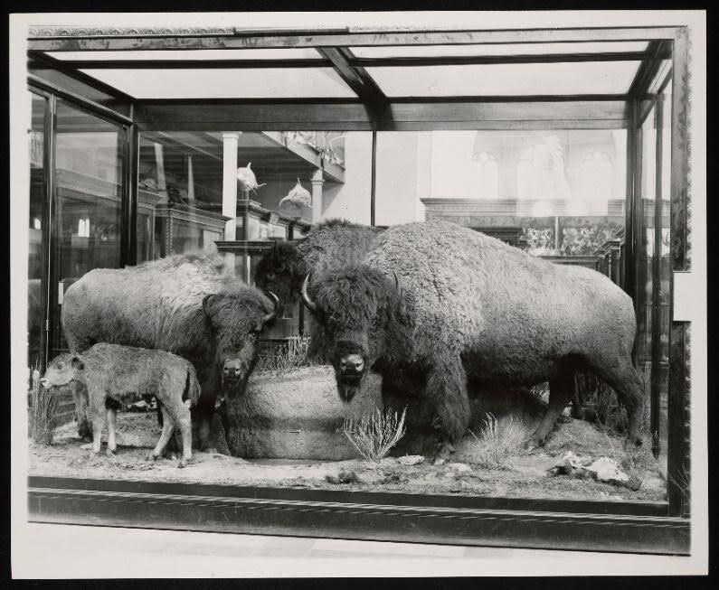
    <title type="html"><![CDATA[Hornaday Bison Exhibit]]></title>
    <summary type="html"><![CDATA[<p><strong><em><span style="font-weight:400;">In 1886, there was genuine concern that the American bison (</span><i><span style="font-weight:400;">Bison bison</span></i><span style="font-weight:400;">) was on the brink of extinction. William Hornaday set out to gather a group of these animals to ensure the preservation of this iconic and once-abundant species. This effort resulted in a collection of six bison, forming one of the most significant representations of this American symbol in the United States.</span></em></strong></p><img src="https://www.intermountainhistories.org/files/fullsize/a329348b27c8e30eb86e7c0d3cd6bf29.jpg" alt="Mammals Exhibit, South Hall, United States National Museum" /><br/><p><span style="font-weight:400;">William Temple Hornaday (1854-1937) was among the first and most notable individuals in the fight to protect the American bison. In his </span><i><span style="font-weight:400;">The Extermination of the American Bison, </span></i><span style="font-weight:400;">Hornaday noted the decimation of the bison and called for the animals’ protection by state and national governments. By 1886, concerns about the potential extinction of the bison loomed, so Hornaday, as Chief Taxidermist at the Smithsonian Institution, traveled to Montana to collect specimens. These bison were some of the last from the wild herds found between the Yellowstone and the Missouri rivers, an area that had witnessed the last Blackfeet buffalo hunt in 1879. </span>
<span style="font-weight:400;">Hornaday killed and conducted the taxidermy on these six bison specimens and exhibited them at the Smithsonian in 1887. They remained there on permanent exhibit until 1955. The Smithsonian decided to dismantle the display and returned them to Montana. The group of bison were split up and put into storage, lost for years. Eventually, Doug Coffman (who studied the history of the bison at the Smithsonian) set out to find them in the 1980s. After being found and restored, the bison were put back on public display in 1996. Today, these six bison can be seen at the Hornaday Smithsonian Buffalo and Dean & Donna Strand Western Art Gallery, located within the Fort Benton Museum & Heritage Complex in Fort Benton, Montana. </span>
<span style="font-weight:400;">The bison are exhibited in the same arrangement in which they originally appeared at the Smithsonian. Notably, the large bull in the collection has served as a model for various national symbols and government designs, including coins, paper currency, postage stamps, and the Great Seal of the Department of the Interior, cementing its place as a symbol of American heritage. In 2016, President Barack Obama signed a bill into law naming the bison as America’s mammal.</span></p><p><em><strong><a href="https://www.intermountainhistories.org/items/show/879">For more (including 3 images) view the original article</a></strong></em></p>]]></summary>
    <published>2025-01-27T03:52:17+00:00</published>
    <updated>2026-04-17T19:32:20+00:00</updated>
    <link rel="alternate" type="text/html" href="https://www.intermountainhistories.org/items/show/879"/>
    <id>https://www.intermountainhistories.org/items/show/879</id>
    <author>
      <name>Dawson Muranaka, Brigham Young University</name>
    </author>
  </entry>
  <entry>
    <title type="html"><![CDATA[The Battle of Glorieta Pass and the Confederate Campaign in New Mexico]]></title>
    <summary type="html"><![CDATA[<p><strong><em><span style="font-weight:400;">The Battle of Glorieta Pass marked a pivotal moment in the American Civil War's Western Theater. Often called the "Gettysburg of the West," this 1862 clash determined the fate of Confederate ambitions as they attempted to expand into New Mexico and beyond.</span></em></strong></p><img src="https://www.intermountainhistories.org/files/fullsize/a7fa00d8af44b7b6e3f361212c0c14d3.jpg" alt="Battle of Glorieta Pass at Pigeon&#039;s Ranch by Roy Andersen" /><br/><p><span style="font-weight:400;">In March 1862, the Battle of Glorieta Pass emerged as a pivotal moment in the Civil War as Confederate troops attempted to seize control of New Mexico, a territory long coveted by the South for its mineral wealth and strategic position along important routes of trade. After capturing Santa Fe on March 13, Brigadier General Henry Hopkins Sibley and his Confederate forces sought to consolidate their gains by advancing toward Fort Union, the last major Union stronghold in the New Mexico territory. However, their path was obstructed by the determined forces of Colonel John Slough, who were preparing to mount a counteroffensive against Sibley’s attack.</span>
<span style="font-weight:400;">Slough's division, bolstered by 800 Colorado volunteers, began their march from Fort Union to engage Sibley’s troops. The Union strategy hinged on thwarting the Confederate advance and securing vital supply lines. As the two armies maneuvered toward each other, they both sought to control the strategic high ground at Glorieta Pass.</span>
<span style="font-weight:400;">On March 28, the two sides met in Apache Canyon, with skirmishes erupting as the Confederate forces attempted to strike the enemy first. Initially caught off guard, the Confederates regrouped and engaged the Union troops ferociously. The fighting soon escalated, with the Union holding the high ground and utilizing artillery to devastating effect against Confederate assaults. Despite this advantage, Colonel Sam Shropshire was killed, a critical blow to the Union’s command. As the battle raged, the Confederate forces made a series of bold charges in an attempt to break through Union lines. They managed to push the Federals back, but their success was tempered by heavy casualties. By the afternoon, Sibley’s forces found themselves at a critical juncture. Their position had begun to erode under the relentless fire of Union artillery, which had effectively neutralized many of their advances.</span>
<span style="font-weight:400;">In a dramatic turn of events, the Confederate forces received alarming news from their base of operations at Johnson’s Ranch. A Union column, led by Captain John Chivington, had launched a surprise attack on the Confederate supply camp, destroying vital resources and inflicting further damage. With eighty supply wagons burned and many pack animals lost the Confederates faced a tenuous situation, exacerbated by their own diminishing supplies. Recognizing the untenable nature of their position at Glorieta Pass, Sibley ordered a retreat to Santa Fe to regroup. Meanwhile, Colonel Slough seized the opportunity to coordinate a follow-up attack, intent on pushing the Confederates further back. The Union forces, now reinvigorated, were ready to capitalize on their opponent’s misfortunes. By March 29th, it was clear to the Confederate commanders that the battle had not yielded the decisive victory they had sought. Retreating to Santa Fe, Sibley hoped to reestablish communication with the Texas government for reinforcements. However, dwindling supplies hampered their efforts, leading to a chaotic withdrawal from the region as they attempted to escape the approaching Union forces. </span>
<span style="font-weight:400;">The Battle of Glorieta Pass marked a turning point in the New Mexico Campaign, symbolizing the failure of Confederate ambitions in the Southwest. Although both sides incurred significant losses—432 Union casualties and 187 Confederate—the aftermath proved disastrous for Sibley’s forces, setting the stage for further Union advances in the territory. The battle ultimately underscored the Confederacy's vulnerability, dashing their hopes of establishing a stronghold in the West, and left them to retreat back to Texas with little more than the remnants of their once-promising campaign.</span></p><p><em><strong><a href="https://www.intermountainhistories.org/items/show/878">For more (including 3 images) view the original article</a></strong></em></p>]]></summary>
    <published>2025-01-27T01:49:52+00:00</published>
    <updated>2026-04-17T19:32:20+00:00</updated>
    <link rel="alternate" type="text/html" href="https://www.intermountainhistories.org/items/show/878"/>
    <id>https://www.intermountainhistories.org/items/show/878</id>
    <author>
      <name>Benjamin Nichols, Brigham Young University</name>
    </author>
  </entry>
  <entry>
    <title type="html"><![CDATA[Thomas Rhoads, The Forgotten Mormon<br />
]]></title>
    <summary type="html"><![CDATA[<img src="https://www.intermountainhistories.org/files/fullsize/8270cbc2aff28b5cd485285278466bee.jpg" alt="Map demonstrating the “Old Spanish Trail” initially used by Colonial Spanish in the late sixteenth century." /><br/><p><span style="font-weight:400;">Born in 1796 in Kentucky, Thomas Rhoads fought for the U.S. Army in the War of 1812. Marrying his first wife Elizabeth Forter in 1817, having sixteen children together, he then converted to The Church of Jesus Christ of Latter-day Saints in Nauvoo, Illinois, in 1835. Rhoads belonged to the Danites and to the Nauvoo Legion as Lieutenant. He moved his family from Illinois to Missouri and finally to California. Rhoads led the first LDS pioneers into future Utah Territory in 1846, before continuing west into California, where he struck gold. After Samuel Brannon refused church leaders’ call to return to Great Salt Lake City, Brigham Young wrote to Rhoads asking him to lead members and tithes back to Salt Lake.</p> <span style="font-weight:400;">Arriving in 1849 at the head of a wagon train, the Saints hailed Rhoads as a hero in a parade wherein Young spoke of Rhoads’ vital contributions of gold to the territory. Submitting four thousand dollars’ worth of gold members had sent as tithing, Rhoads then gave his own seventeen thousand dollars of gold. In exchange Rhoads was given an exceptional plot of land near the temple in Salt Lake and credited with over ten thousand dollars in the church bank ledger, the only man to receive his own dedicated page in the ledger aside from Brigham Young himself.</p> <span style="font-weight:400;">Rhoads served Brigham Young in many ways to help establish Utah Territory’s economic footing over the coming years. Young handpicked Rhoads multiple times to accompany him on scouting parties around the state to determine future settlements. Furthermore, Rhoads continued to provide a steady supply of gold each year to the Mormon mint. Multiple primary sources describe his deliveries in person; however, the church ledgers do not record the deposits, and scholars debate the amounts. Ultimately, the income was crucial to the young community facing extreme opposition as minted gold coins contributed to the perpetual immigration fund as well as construction of the temple.</p> <span style="font-weight:400;">Just as the amount is contested, so are the various sources. Accounts detail how Rhoads knew about a multitude of old mines in the mountains, abandoned by the Spanish. Several of these mines have been located and confirmed, others were claimed to have been found but were not accessible, while others still are lost. Most controversial amongst these is “Carre Shin Ob” located near White Rocks Canyon in the Wasatch Forests of Eastern Utah. As the story goes, in 1852 Brigham Young and Utes Chief Walker entered an arrangement thanks to Isaac Morely, wherein Rhoads would be permitted to travel alone deep into Indian territory to retrieve gold for the Mormon church. Walker was a convert and believed in the church, giving three simple rules: only Rhoads may know the location, he only takes the specified amount, and no Ute Indians would transport gold.</p> <span style="font-weight:400;">Dozens of accounts detail Rhoads’ travels; and the days absent compared to confirmed distance traveled proves wherever Rhoads retrieved gold from, he did not have to mine it himself. Scientific analysis of remaining Mormon mint coins matches the chemical makeup of old Spanish gold mined in the era. There are critiques that doubt the stories of Rhoads’ lost mine; regardless, Rhoads gathered gold from somewhere and this gold was immensely important to the foundation of Salt Lake City and eventually Utah.</span></p><p><em><strong><a href="https://www.intermountainhistories.org/items/show/877">For more (including 4 images) view the original article</a></strong></em></p>]]></summary>
    <published>2025-01-25T03:15:14+00:00</published>
    <updated>2026-04-17T19:32:20+00:00</updated>
    <link rel="alternate" type="text/html" href="https://www.intermountainhistories.org/items/show/877"/>
    <id>https://www.intermountainhistories.org/items/show/877</id>
    <author>
      <name>Travis Sorensen, Brigham Young University</name>
    </author>
  </entry>
  <entry>
    <title type="html"><![CDATA[Curtis Edwin Bolton, Founder of Boltonheim, Utah]]></title>
    <summary type="html"><![CDATA[<p><strong><em><span style="font-weight:400;">The winds of time swept the frontier town of Boltonheim, Utah Territory, into historical obscurity. Its founder, Curtis Edwin Bolton, served as postmaster from 1878-1880. </span></em></strong></p><img src="https://www.intermountainhistories.org/files/fullsize/3e28561583744c431a467eba45d02141.jpg" alt="Bureau of Land Management, “Survey Search” from General Land Office Records" /><br/><p><span style="font-weight:400;">Sent by his wealthy merchant father, Curtis Edwin Bolton sailed to Europe in 1832 to study French and German, leaving his fiancée </span><span style="font-weight:400;">behind in New York. At twenty-years-old Curtis Edwin Bolton was 5’9” with blue eyes and black hair. He returned stateside in the fall of 1834. As a new convert, he pilgrimaged with the diaspora of The Church of Jesus Christ of Latter-day Saints to the Great Salt Lake Valley in 1848. His first winter, he taught French in the evenings in their bedbug-infested fort. In 1849, Curtis accepted a mission call to serve in France, embarking with a small group of missionaries.</span>
<span style="font-weight:400;">While Curtis labored to translate the Book of Mormon into French in his Paris apartment in 1851, a tangible stillness fell upon the noisy bustling city as Louis-Napoléon Bonaparte’s troops flooded through the streets nearby. On signal, the soldiers leveled their weapons at the innocent bystanders watching out their windows. With an infernal roar of artillery, they bombarded thousands of men, women, and children. After hiding in his apartment for two days, Curtis stepped out, stunned by the destruction of the coup d’état. He resided in France until 1853. </span>
<span style="font-weight:400;">Life pulled him to the frontier desert areas of southern Utah Territory. He led a Fourth of July celebration in Santaquin, rode the rapids in the Muddy Mission, and taught school in Long Valley and Monroe. Popular in local elections, he served as Piute County Clerk and Justice of the Peace, in addition to merchant, miner, and sawmill owner. </span>
<span style="font-weight:400;">Proud of his robust nature, he boasted he could walk fifty miles in one day. His strength and endurance fueled many of his accomplishments. In his sixties, he homesteaded in Piute County near the Sevier River, where he built his final home, a two-room log house with a shingle roof and board floor. He also dug miles of irrigation ditches and cultivated twenty acres (SLC Land Office, Curtis Bolton homestead file). He founded a town called Boltonheim, meaning “Bolton home” in German, located five miles south of Marysvale, where he served as the postmaster from 1878 until 1880. In those days, a letter only cost three cents for postage.</span>
<span style="font-weight:400;">A stroke in 1883 prompted Curtis to transfer ownership of his homestead to Sarah Howes, in exchange for her pledge of lifelong care. After battling stiffness in his right hand for two years, he stepped down from his role as county clerk at the age of seventy-three. Curtis’s life reflects the adventurous drive that brought many pioneering individuals westward.</span></p><p><em><strong><a href="https://www.intermountainhistories.org/items/show/876">For more (including 6 images) view the original article</a></strong></em></p>]]></summary>
    <published>2025-01-25T02:32:23+00:00</published>
    <updated>2026-04-17T19:32:20+00:00</updated>
    <link rel="alternate" type="text/html" href="https://www.intermountainhistories.org/items/show/876"/>
    <id>https://www.intermountainhistories.org/items/show/876</id>
    <author>
      <name>Connie L. Vance, Brigham Young University</name>
    </author>
  </entry>
  <entry>
    <title type="html"><![CDATA[The Lonetree Mercantile and Post Office]]></title>
    <summary type="html"><![CDATA[<p><strong><em><span style="font-weight:400;">In the center of a ranching town called Lonetree, there is an old building with a white façade and log construction that once functioned as the Post Office and mercantile store for the remote community. From 1897 to 1982, the store served as the nerve center for the community.</span></em></strong></p><img src="https://www.intermountainhistories.org/files/fullsize/de8a2ff11079a55bb74a187bf6522441.jpg" alt="Ranchers pose in front of the Lonetree Mercantile. " /><br/><p><span style="font-weight:400;">Lonetree, Wyoming, is situated just north of the high Uinta Mountains and twenty miles south of Fort Bridger. Henrys Fork River, a tributary of the Green River, first brought fur-trading Europeans to the area. Those who stayed were the descendants of LDS pioneer Captain Isaac Bullock. Bullock was sent to the area by Brigham Young in the early 1850s.</span><span style="font-weight:400;"> The Bullocks were joined by many other families. These homesteaders eventually turned to ranching. </span>
<span style="font-weight:400;">In 1897, an immigrant from Manchester, England, named Herbert Joshua Gregory came to Lonetree. Since the old post office run by R. Handley had burned down, Gregory built his own.</span><span style="font-weight:400;"> Gregory’s store provided necessary supplies and correspondence to the ranchers and townspeople in the area. A visitor to the store could expect news of deaths, births, stolen livestock, grazing permits, events, and even outlaws.</span><span style="font-weight:400;"> Dances, turkey hunts, games, and gatherings of all kinds took place around the Gregory store.</span><span style="font-weight:400;"> It is said that Butch Cassidy and the Sundance Kid were among the outlaws who stopped by Gregory’s store and interacted with members of the community.</span><span style="font-weight:400;"> Gregory was the postmaster until his death in 1952, and the title of postmaster would remain in his family until 1982 when the post office closed.</p><span style="font-weight:400;">Thanksgiving in Lonetree, 1890, made for a popular story. It is said that a Pinkerton agent came to the Gregory store and formed a posse to catch two outlaws who were riding towards Lonetree. One of the outlaws was Harry Alonzo Longabaugh or the Sundance Kid. H. J. Gregory, the town fiddler, and several others rode out to apprehend them. With no fiddler, the Thanksgiving dance could not begin. While people milled around the schoolhouse, Harry Longabaugh and his partner walked into the Gregory store. The story says that the townspeople captured Longabaugh and made him play the fiddle for their dance where he stayed long enough to dance with a woman and escape before the return of the Pinkerton agent.</span><span style="font-weight:400;"> </span>
<span style="font-weight:400;">Lonetree remains a ranching community with a small population that has not forgotten its origins in the Wild West.</span></p><p><em><strong><a href="https://www.intermountainhistories.org/items/show/875">For more (including 4 images) view the original article</a></strong></em></p>]]></summary>
    <published>2025-01-23T00:33:27+00:00</published>
    <updated>2026-04-17T19:32:20+00:00</updated>
    <link rel="alternate" type="text/html" href="https://www.intermountainhistories.org/items/show/875"/>
    <id>https://www.intermountainhistories.org/items/show/875</id>
    <author>
      <name>Landon Wilson, Brigham Young University</name>
    </author>
  </entry>
  <entry>
    <title type="html"><![CDATA[Parowan Gap Petroglyphs]]></title>
    <summary type="html"><![CDATA[<img src="https://www.intermountainhistories.org/files/fullsize/ae788130d6314850832eb9fc11464fb9.jpg" alt="Ancient carvings were made by Natives passing through Parowan Gap" /><br/><p>Over a thousand years ago, Fremont Indians inhabited southern Utah in an area known as the Parowan Gap. Once a flowing river, the Parowan Gap dried out over time. Erosion by wind and rain have further shaped this 600 foot deep notch or pass used by Natives and newcomers to traverse the Red Hills, a low range of mountains that forms the western border of the Parowan Valley. Hopis, Utes, and Paiutes used this area to travel back and forth to obtain resources and mingle with one another. </p><p>About 13 miles west of Parowan are the famous petroglyphs, carved or pecked into the sedimentary rock walls of this historic landmark. Petroglyphs depict images of people, animals and different lines and shapes, although the meaning of some of the depictions remains a mystery. Images of humans, snakes, mountain sheep, and lizards fill the wall panels. Archaeologists believe the gallery represents rock art extending over a thousand years. Some researchers postulate the wall was used for religious purposes and others contend the engravings represent a hunting ritual. One petroglyph depicts a calendrical system indicating when to plant and harvest crops. Zipper Glyph, the most famous petroglyph, depicts the route Paiutes traveled and indicates how long their journey through the gap might take. </p><p>The petroglyphs at Parowan Gap are fragile and can be ruined by human touch or by trying to chalk over them. Enjoy them at a distance by taking a photo or sketching them yourself. Everyone shares a responsibility to help preserve archaeological and historically significant sites.</p><p><em><strong><a href="https://www.intermountainhistories.org/items/show/857">For more (including 3 images) view the original article</a></strong></em></p>]]></summary>
    <published>2024-09-25T20:44:31+00:00</published>
    <updated>2026-04-17T19:32:19+00:00</updated>
    <link rel="alternate" type="text/html" href="https://www.intermountainhistories.org/items/show/857"/>
    <id>https://www.intermountainhistories.org/items/show/857</id>
    <author>
      <name>Samantha Worthington, Brigham Young University</name>
    </author>
  </entry>
  <entry>
    <title type="html"><![CDATA[The Nephi Massacre during Wakara’s War<br />
]]></title>
    <summary type="html"><![CDATA[<p><strong><em>During Wakara’s War in 1853-54 a group of Utes killed four Mormons at Fountain Green.  The next day, Mormons killed eight Utes or Goshutes seeking peace with LDS settlers in Nephi, Utah. The discovery of their remains in Nephi’s Old Hallow in 2006 highlighted the brutality of Wakara’s War, a series of conflicts during 1853 between settlers and Indigenous residents in central Utah Territory.</em></strong></p><img src="https://www.intermountainhistories.org/files/fullsize/fafd241883d271d8b9793e3097ca8da1.jpg" alt="Nephi, Utah" /><br/><p>In 2006, an archaeological discovery in Nephi, Utah, shed light on a tragic event that occurred in 1853 during the Walker War, also known as the Wakara War. The excavation revealed a mass grave containing the remains of seven Goshutes, including a young boy. The bodies were found piled on top of each other. Forensic analysis discovered gunshot wounds, shattered bones, and evidence of blunt force trauma.</p><p>The Wakara War between settlers and Utes was infuriated by the encroachment of additional LDS settlements in Utah and Sanpete counties in Utah Territory. The incident in Nephi occurred on October 2, 1853, when a group of Utes or Goshutes came to the fort. The account reported in the Deseret News portrayed the Natives as aggressors in a tussle they initiated with the militia. Recent research, including the discovery of journals of witnesses Adelia Wilcox and Martha Spence Heywood, however, contradict this narrative.</p><p>The forensic evidence from the mass grave suggests that the Native men, ranging in ages from 16 to 25, were not killed in a skirmish but were executed. Gunshot wounds in the back of the head and traumatic injuries indicate a cold-blooded killing, challenging the original historical account. The discovery of the mass grave by construction workers laying a foundation for a home in 2006 provided an opportunity to combine scientific discovery, archaeology and forensic analysis, and historical records to correct and update the historical narrative and include the perspectives of those killed. The story of the Nephi mass grave is a significant reminder of the complexities surrounding historical narratives and how archaeological revelations can amend those stories.</p><p><em><strong><a href="https://www.intermountainhistories.org/items/show/856">For more (including 3 images) view the original article</a></strong></em></p>]]></summary>
    <published>2024-09-25T15:00:26+00:00</published>
    <updated>2026-04-17T19:32:19+00:00</updated>
    <link rel="alternate" type="text/html" href="https://www.intermountainhistories.org/items/show/856"/>
    <id>https://www.intermountainhistories.org/items/show/856</id>
    <author>
      <name>Chelsea Woodruff, Brigham Young University</name>
    </author>
  </entry>
  <entry>
    <title type="html"><![CDATA[Rebranding Mount Doane to First Peoples Mountain in Yellowstone]]></title>
    <summary type="html"><![CDATA[<p><strong><em>Mount Doane, a prominent mountain in Yellowstone National Park, was named in honor of Lt. Gustavus Doane, an early explorer of the park. However, his mistreatment of Native people has led the park to collaborate with Native communities to rename the peak First Peoples Mountain. </em></strong></p><img src="https://www.intermountainhistories.org/files/fullsize/890b4c397eef6073bf635775a998d2aa.jpg" alt="Mounts Doane and Stevenson, east of southwest arm of Yellowstone Lake" /><br/><p>Lieutenant Gustavus C. Doane ventured through Yellowstone National Park in the early 1870s on a commission by the United States government to explore the western territory. In 1871, the Hayden Geological Survey named a prominent mountain after the military leader, effectively preserving his legacy. Mount Doane stood as a monument to the lieutenant’s efforts and exploration in the West. But this narrative by the Geological Survey left much untold. </p><p>Doane participated in several conflicts with Native people including the Sioux War, the Nez Perce War, and the Apache Campaign in the years leading up to his exploration of Yellowstone. In 1870, he led an attack against the Piikani/Piegan Blackfeet, now known as the Marias Massacre. On January 23, 1870, the United States Army attacked Chief Heavy Runner’s Piegan village at dawn, killing some 173 people, including elderly and children. The camp had been ravaged by smallpox, leaving them defenseless. Such an atrocity went unacknowledged while Mount Doane stood as a legacy to one of the men who perpetrated it. </p><p>To better represent Indigenous peoples and their histories, Yellowstone National Park sought to change the name of Mount Doane and other controversially named sites. The park reached out to organizations like the Rocky Mountain Tribal Council and the Wyoming Board of Geographic Names. In collaboration with and recommendations by these groups, the National Park Service changed the peak’s name to First Peoples Mountain on June 9, 2022. With a vote of 15-0 in support of the change by the US Board on Geographic Names, the mountain became a monument to the memory of the people killed in the Marias Massacre. This change marks an important shift in the ways Indigenous peoples are represented in the historical narrative and historical memory. </p><p><em><strong><a href="https://www.intermountainhistories.org/items/show/855">For more (including 2 images) view the original article</a></strong></em></p>]]></summary>
    <published>2024-09-25T04:33:01+00:00</published>
    <updated>2026-04-17T19:32:19+00:00</updated>
    <link rel="alternate" type="text/html" href="https://www.intermountainhistories.org/items/show/855"/>
    <id>https://www.intermountainhistories.org/items/show/855</id>
    <author>
      <name>Lauren Barney, Brigham Young University</name>
    </author>
  </entry>
  <entry>
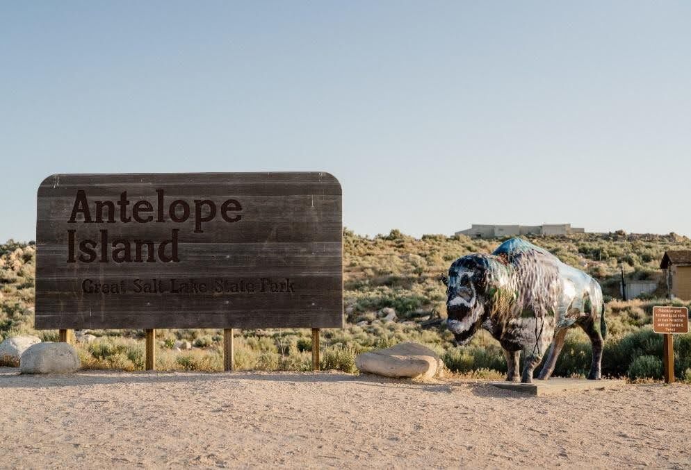
    <title type="html"><![CDATA[Indigenous Inhabitants of Antelope Island ]]></title>
    <summary type="html"><![CDATA[<p><strong><em>The history of Indigenous interactions with Antelope Island, as documented through oral histories, artifacts, and written accounts, reveals a rich and diverse relationship over thousands of years.</em></strong></p><img src="https://www.intermountainhistories.org/files/fullsize/9ab62dc8307a1a682b90b16c59114809.jpg" alt="Antelope Island Great Salt Lake State Park " /><br/><p>Antelope Island holds great historical and geographical significance to the current and previous inhabitants of the Great Salt Lake, whose water levels rose and fell repeatedly. The interactions and ties between Natives and the Island are deeply embedded in the island’s history, encompassing exploration, resource utilization, cultural exchanges, and adaptation over millennia. </p><p><strong>Paleo, Archaic, and Fremont Peoples:</strong> </p><p>The earliest residents of Antelope Island, Paleo peoples, are estimated to have arrived in the region over 12,000 years ago. Like more recent Indigenous peoples, First peoples found the area accommodating for hunting, gathering, fishing, and insect roasting. These shoreline populations resided in caves, bush dwellings, or shelters constructed with nearby natural resources. Shoreline peoples hunted geese and rabbits and gathered berries, roots, and seeds along the Great Salt Lake’s shoreline. As climate changes occurred, island inhabitants adapted. The transition from Paleo-Indians to Archaic peoples (roughly 8000 B.C.E.) and later to the Fremont (300 B.C.E.) is evident, with each group utilizing the island’s resources differently. Archaic peoples used fine-pointed spears to hunt megafauna, big game, smaller mammals, rodents, and birds. About 2,000 years ago, the Fremont practiced many of the same food gathering techniques as their predecessors, but also farmed corn and traded with the southern Ancestral Puebloans. Around 1100 A.D., immigrants from southern California entered the scene and marked the end of the Salt Lake Fremont era, transitioning into occupation by the Numic speaking peoples including the Shoshones, Utes, and Goshutes. </p><p><strong>Nineteenth century:</p> </p><p>Explorers John C. Fremont and Kit Carson arrived at Antelope Island in 1845 and recorded some of their first impressions of the island and its wildlife. One of their most notable discoveries was Native encampments on the island. Numic-speaking peoples frequented the island. According to one account, Fremont consulted Utes residing in the area regarding the nature of the island before he and Carson explored it. The Utes said the party could easily reach the island on horseback. The explorers described their trip across the shallows to the island. The water never rose above their saddle girths. They described the lake floor as a sheet of salt resembling softening ice, into which the horses’ feet sank to their fetlocks. A variety of wildlife species lives on Antelope Island, including antelope. Fremont and his men killed an antelope for sustenance in the 18. After returning from the island, a Native man informed Fremont’s party that the antelope they had killed was one from his herd of antelope. To avoid any tension or conflict, Fremont gave the man cloth, tobacco, and a knife in exchange for their venison dinner. Ongoing Research and </p><p><strong>Conservation:</strong> </p><p>Contemporary archaeological efforts continue to survey and excavate Antelope Island, aiming to uncover prehistoric cultural sites. Discoveries, such as ancient spear points and metates, contribute to our understanding of the island’s long Indigenous occupation. Biologists monitor archaeological findings to identify native species for potential reintroduction to the island. The water level of the Great Salt Lake surrounding Antelope Island fluctuates up and down. On September 30, 2023, Native representatives from various tribes came together to offer a ceremonial blessing of healing. Former tribal chairman of the Northwest Band of Shoshones Darren Parry, Paiute Tribe of Utah Chairwoman Corrina Bow, and members of the Kanosh band participated in the event.</p><p><em><strong><a href="https://www.intermountainhistories.org/items/show/854">For more (including 4 images) view the original article</a></strong></em></p>]]></summary>
    <published>2024-09-25T03:39:42+00:00</published>
    <updated>2026-04-17T19:32:19+00:00</updated>
    <link rel="alternate" type="text/html" href="https://www.intermountainhistories.org/items/show/854"/>
    <id>https://www.intermountainhistories.org/items/show/854</id>
    <author>
      <name>Ethan Cornelius, Brigham Young University</name>
    </author>
  </entry>
  <entry>
    <title type="html"><![CDATA[St. Mary’s Mission in the Pacific Northwest]]></title>
    <summary type="html"><![CDATA[<p><strong><em>Father Pierre-Jean De Smet brought Christianity to Native peoples in Idaho and Montana through the construction of St. Mary’s Mission. With it came Catholic conversion among some Salish (Flatheads) and Nez Perce, and conflict with the Blackfeet.</em></strong></p><img src="https://www.intermountainhistories.org/files/fullsize/439956b4dff81e2ade29e5724487f46c.jpg" alt="[Untitled]" /><br/><p>A few members of Salish speaking tribes, also referred to as “Flatheads,” traveled to St. Louis in the 1830s and requested the Catholic Church send missionaries to construct a mission to teach them about Christianity and the Bible. Father Pierre-Jean De Smet, Society of Jesus, was a Flemish Jesuit priest who answered the call, traveling west with fur traders and Catholic Mohawks. He founded the Catholic mission of St. Mary’s in 1841 to provide schools, storehouses, farms, workhouses, and religious instruction. </p><p>De Smet and the St. Mary’s Mission abided by four overarching rules. First: respect the Catholic Church with submission and a desire to learn about the gospel. Second: respect your neighbors and obey those in positions of authority. Third: develop attributes such as humility, charity, and temperance for self-improvement. Fourth: limit contact between Natives and settlers who may not help cultivate Christian values.</p><p>The presence of St. Mary’s had a profound effect on many Natives. Some Salish were baptized and the mission counted converts as a sign of the mission’s success. Others, such as the Blackfeet, loathed the mission and waged war upon it, destroying the mission in 1850.</p><p>Pierre-Jean De Smet, as the mission’s supervisor, played a large role not only in spreading the gospel message, but also as a community leader. He presided over marriages, baptisms, and other ecclesiastical functions as well as social issues relating to farming, government, and interactions with outsiders. The community looked up to him as a protector and he often counseled Native leaders on matters concerning war and policy. Other Salish rejected De Smet and the Catholic intrusion in their lives and adhered to traditional teachings and practices.</p><p>Located near Stevensville, Montana, Historic St. Mary’s Mission is on the National Register of Historic Places. Buildings include the chapel, Father Ravalli’s cabin, Chief Victor’s Cabin, Ox Cart barn, Dove Cote, Smoke House, Diorama, Salish encampment, and apple orchard. A visitor center houses a museum, gift shop, office, art gallery, and research library. Volunteers serve as tour guides, grounds keepers, clerical workers, and operate a museum and gift shop.</p><p><em><strong><a href="https://www.intermountainhistories.org/items/show/853">For more (including 4 images) view the original article</a></strong></em></p>]]></summary>
    <published>2024-09-25T03:24:33+00:00</published>
    <updated>2026-04-17T19:32:19+00:00</updated>
    <link rel="alternate" type="text/html" href="https://www.intermountainhistories.org/items/show/853"/>
    <id>https://www.intermountainhistories.org/items/show/853</id>
    <author>
      <name>Samuel G. Dunn, Brigham Young University</name>
    </author>
  </entry>
  <entry>
    <title type="html"><![CDATA[Oraibi, Arizona: A Resilient Hopi Community ]]></title>
    <summary type="html"><![CDATA[<p><strong><em>Discovered in 1540 by the Spanish explorer Pedro de Tovar, Oraibi, a Hopi residence, is regarded as one of the longest continuously inhabited settlements in the United States. Its people have endured centuries of drought, colonial pressures, and internal and external conflict. Oraibi remains a visible reminder of the resilient spirit of the Hopis.</em></strong></p><img src="https://www.intermountainhistories.org/files/fullsize/fb072444d0994c36619ad1169908c110.jpg" alt="Low oblique view from above the Hopi village of Oraibi, showing terraced houses, Arizona, 1898" /><br/><p>Oraibi has existed since at least 1100 AD, but due to the paucity of archaeological research, it may have been occupied much earlier. Located in Northern Arizona and situated atop the 3rd Mesa of the Hopi Nation. Spanish explorer Francisco Vázquez de Coronado sent Pedro de Tovar and 20 men to make contact in 1540. The Spanish built the San Francisco mission in 1629, but the Hopis destroyed the mission in 1680 during the Pueblo revolt. Oraibi represented one of the central Hopi village sites until the turn of the twentieth century, when some of its population relocated in 1906.</p><p>Throughout Oraibi’s history, the city has not only undergone population fluctuations but also architectural reformation. An examination of thousands of photographs, prints, and detailed maps dating back to the 1800s reveal the first houses in Oraibi were one room wide and often four stories tall. The town was structured so houses were built in long, linear room blocks, with adjacent houses sharing walls. There were 25 room blocks that most faced southeast. Toward the end of the 19th century, when Navajo raids became less common, many upper stories of the shelters were dismantled, as living on lower stories became preferred. European materials such as glass windows, milled lumber, and woodburning stoves were added within Oraibi architecture. The introduction of stoves led to an increase in room size, allowing for the heating of larger spaces. After 1906 many room blocks were abandoned as people consolidated into the west part of the village near the main plaza.</p><p>Oraibi remains a vibrant testament to the Hopi spirit of resilience. The peaceful people of Oraibi have endured centuries of drought, colonial pressures, and conflicts with other Indigenous peoples. The current residents of Oraibi are private, and while they are welcoming to visitors, they ask them to refrain from taking pictures or videos. The remarkable settlement of Oraibi offers unique insight into Indigenous America and contributes profoundly to Hopi history.</p><p><em><strong><a href="https://www.intermountainhistories.org/items/show/852">For more (including 4 images) view the original article</a></strong></em></p>]]></summary>
    <published>2024-09-25T02:44:44+00:00</published>
    <updated>2026-04-17T19:32:19+00:00</updated>
    <link rel="alternate" type="text/html" href="https://www.intermountainhistories.org/items/show/852"/>
    <id>https://www.intermountainhistories.org/items/show/852</id>
    <author>
      <name>Samuel Fuller, Brigham Young University</name>
    </author>
  </entry>
  <entry>
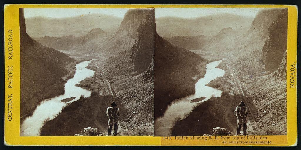
    <title type="html"><![CDATA[The Humboldt River and the Inevitable Railroad]]></title>
    <summary type="html"><![CDATA[<p><strong><em>Alfred A. Hart’s photo neatly captures the relationship that the United States had with Indigenous nations in the 19th century: persistent encroachment on and abuse of Native land. </em></strong></p><img src="https://www.intermountainhistories.org/files/fullsize/68061ca83529f9dba3c1da8a26419a79.jpg" alt="“Indian viewing railroad from top of Palisades. 435 miles from Sacramento.” " /><br/><p>Winding through the arid region of modern-day north central Nevada, the Humboldt River provided resources to support communities of a few hundred people. Punodungahnivain, or “Place where the house is” in Western Shoshone, was an area at the mouth of the South Fork River, between modern-day Carlin, Elko, and South Fork, that was home to Western Shoshone. </p><p>Water—and therefore the river—is sacred for the Western Shoshone, or “Newe” meaning “The People.” The Humboldt represents an important thoroughfare in ancient and modern trade routes, connecting goods from the Pacific with those in the Great Basin and western Rocky Mountains. The fertile river enabled Indigenous communities to thrive between modern-day Carlin and Elko. Roots and berries grew along the river, attracting birds and animals, and pine nut resources grew in the nearby Ruby mountains. The Shoshones hunted waterfowl, antelope, trout, gopher, rabbit, and beaver. </p><p>Trappers such as Peter Skene Ogden from the Hudson’s Bay Company arrived in the Humboldt region in the 1820s. They trapped as many beavers as possible in order to make it unprofitable for their competition, nearly wiping out the beaver population for a generation. After the discovery of gold at Sutter’s Mill in 1848, miners and settlers traveled along the Humboldt by the tens of thousands, negatively impacting the environment, depleting finite resources, and disrupting Indigenous lifeways. The California Trail transected Western Shoshone Territory throughout the 1840s through 1860s. Then, in the 1860s, the Central Pacific Railroad began building their Railroad from Sacramento, California, westward towards Utah Territory to join with the Union Pacific at Promontory Summit on May 10, 1869. </p><p>By the time CPRR worker Alfred A. Hart took the photo below, dated between 1865 and 1869, natural resources had already been depleted all along the Humboldt. Hart took hundreds of photographs as he traveled with the company, and many of them feature Shoshones. The completion of the railroad brought even more people west, who settled near the tracks in order to benefit from future commerce. These newcomers claimed the most fertile places for themselves and divided up ancestral Shoshone and Paiute lands. </p><p><em><strong><a href="https://www.intermountainhistories.org/items/show/851">For more (including 3 images) view the original article</a></strong></em></p>]]></summary>
    <published>2024-09-25T01:12:50+00:00</published>
    <updated>2026-04-17T19:32:19+00:00</updated>
    <link rel="alternate" type="text/html" href="https://www.intermountainhistories.org/items/show/851"/>
    <id>https://www.intermountainhistories.org/items/show/851</id>
    <author>
      <name>Ella Henricksen, Brigham Young University</name>
    </author>
  </entry>
  <entry>
    <title type="html"><![CDATA[Shoshone Falls: The Niagara of the West]]></title>
    <summary type="html"><![CDATA[<p><strong><em>If you are heading through Twin Falls, Idaho on Interstate 84, you’ll want to take a short detour on U.S. highway 93 to Shoshone Falls Park, located on the Snake River.</em></strong></p><img src="https://www.intermountainhistories.org/files/fullsize/82f0a7cd60a9208c11e4d9917e0e0bc2.jpg" alt="Thomas Moran, Shoshone Falls, 1900, oil, Gilcrease Museum, Tulsa, Oklahoma." /><br/><p>Before the days of irrigation water and hydroelectricity, Shoshone Falls was an amazing sight to behold, water plunging 212 feet over the rocks, with the roar of the falls heard up to ten miles away. The falls created an impassable barrier for the migrating steelhead and salmon returning from the Pacific Ocean to spawn. In the spring, Indigenous people living throughout the Snake River Plain formed small bands to capture fish from the river and it remained an important area for Natives to gather, fish, and trade.  Downstream, fish were plentiful and provided life-sustaining food and an important component of Shoshone culture and spirituality.   </p><p>Archaeologists insist Shoshone Falls was formed over 14,500 years ago when Lake Bonneville catastrophically flooded during the Pleistocene Ice Age. A traditional Shoshone-Bannock story denotes a different story explaining the cosmology of the Shoshone/Snake River. Ejuba, a coyote, went fishing in the country of Yellowstone. On his way home, the fish and the water in his lined basket became too heavy to carry and he tripped and spilled the contents. Although he tried several times to build various rocky dams to contain the spilled water, it continually rushed over and created several waterfalls. The river that Ejuba created is known today as the Snake River. The first dam he built was Idaho Falls, the second was American Falls, and the third dam split into two parts to become Twin Falls. The last and largest dam Ejuba constructed was Shoshone Falls. Another Shoshone tale describes a maiden distraught over the separation from her lover who hurled herself into the Snake River canyon at a point near the edge of the falls, a fenced off area known as “Lover’s Leap.”</p><p>Shoshone Falls has undergone tremendous changes. The once roaring waters that were heard from miles away now dwindle to a stream. The demand for water to irrigate the land and the desire for clean hydroelectricity dictates the amount of water that plunges over the falls. When visiting the falls on such a day it is hard to imagine that a writer once compared Shoshone Falls to Niagara Falls saying, “Surely there must be a God above. . .who made these Western Falls, which soon shall mock the magic art of Eastern ones and sink them into insignificance.” Visit the falls in the early Spring if you hope to catch a glimpse of its original majesty at maximum flow. </p><p><em><strong><a href="https://www.intermountainhistories.org/items/show/850">For more (including 2 images) view the original article</a></strong></em></p>]]></summary>
    <published>2024-09-24T18:23:02+00:00</published>
    <updated>2026-04-17T19:32:19+00:00</updated>
    <link rel="alternate" type="text/html" href="https://www.intermountainhistories.org/items/show/850"/>
    <id>https://www.intermountainhistories.org/items/show/850</id>
    <author>
      <name>Rochelle A. Hewett, Brigham Young University</name>
    </author>
  </entry>
  <entry>
    <title type="html"><![CDATA[Dowa Yalanne Mountain]]></title>
    <summary type="html"><![CDATA[<p><strong><em>Many notable events for the Zuni people transpired on Dowa Yalanne, including traditional legends and ceremonies. It provided the Zunis protection against the invading Spanish and other raiding groups and continues to inspire and remind the Zuni people of their culture and history.</em></strong></p><img src="https://www.intermountainhistories.org/files/fullsize/ae143c3a012b84adff08586fd045f838.jpg" alt="“Dowa Yalanne Mountain.”" /><br/><p>Located in New Mexico on the Zuni reservation, Dowa Yalanne, or Corn Mountain, overlooks Zuni Pueblo at an elevation ranging in the 7000s. A Zuni legend explains that during an intense flood, the people fled to the top of the Dowa Yalanne, bringing their corn. To cause the water to recede, they sent a son and daughter of a Zuni priest into the water as an offering. Eventually the waters receded, revealing that the son and daughter turned to stone. Corn Mountain’s mesa features approximately 320 acres of Zuni sandstone, mudstone, and Dakota sandstone. Based on these sedimentary rocks, Dowa Yalanne appears to have formed during the Triassic and Jurassic periods and is recognizable by its red and white coloring. Piñon-juniper trees populate the mountain, along with smaller brush and foliage. </p><p>During the early days of European contact, Dowa Yalanne offered the Zuni people refuge from the Spanish conquistadors. In 1540, after Francisco Vasquez Coronado and his men battled at the Zuni village of Hawikuh, the remaining Zunis fled to Corn Mountain to escape Spanish occupation. Familiar with the mountain trails, they remained secluded until the Spanish left. The Zuni then returned to their villages once it appeared safe. </p><p>Zunis utilized Dowa Yalanne as a place of retreat before contact with the Spanish when conflict arose with other tribes. Zunis returned to Dowa Yalanne in 1632 after they conspired and killed two Franciscan Friars and Spanish soldiers stationed at Hawikuh. It was not until 1635 that the people of the six Zuni villages entirely left the mountain’s protection. This particular cycle continued in 1680, after the immediate events of the Pueblo Revolt, and again in 1703 when the Zunis repulsed Spanish interlopers.  From that point on, the use of Dowa Yalanne as a place of protection significantly diminished due to fewer conflicts.</p><p>Zuni rock art decorates Dowa Yalanne in locations where they took refuge. The historic engraved shields and mountain lion iconography served a magical protective function for them. Zunis still maintain sacred shrines on the top of Dowa Yalanne mesa, cementing its spiritual reminder of Zuni culture and resilience during difficult circumstances.</p><p><em><strong><a href="https://www.intermountainhistories.org/items/show/849">For more (including 4 images) view the original article</a></strong></em></p>]]></summary>
    <published>2024-09-24T18:01:38+00:00</published>
    <updated>2026-04-17T19:32:19+00:00</updated>
    <link rel="alternate" type="text/html" href="https://www.intermountainhistories.org/items/show/849"/>
    <id>https://www.intermountainhistories.org/items/show/849</id>
    <author>
      <name>Joseph Namingha, Brigham Young University</name>
    </author>
  </entry>
  <entry>
    <title type="html"><![CDATA[Geronimo Surrender Monument]]></title>
    <summary type="html"><![CDATA[<p><strong><em>For many years, the ferocity and war tactics of the Chiricahua Apaches deterred the American military from taking their land in Arizona. General William T. Sherman became so frustrated by the Apache that he suggested Arizona should be abandoned to the American Indians. Despite these resilient efforts in maintaining their land, the Chiricahua surrendered to preserve their people from a “bitter end.” The Geronimo Surrender Monument stands as a stark reminder in Skeleton Canyon of southern Arizona. </em></strong></p><img src="https://www.intermountainhistories.org/files/fullsize/ab99b990d9a8de68c67dae2ffd6fa20b.jpg" alt="Apache Gaan dancers " /><br/><p>The Chiricahua Apaches settled in southeastern Arizona, southwestern New Mexico, and northern Mexico in the Sonoran and Chihuahuan Deserts. They fielded fierce warriors with agile, athletic builds that proved a formidable fighting force in the desert Southwest. Apaches constructed easily built dome-shaped wickiup dwellings made of thatch and poles and covered with animal skins.</p><p>Few Americans entered Chiricahua territory before the gold rush. The 1851 discovery of gold in the Pinos Altos region of New Mexico, which lay at the Southern end of the Black Mountains, homeland of the Warm Springs Band of Chiricahua, was an early source of conflict. Apaches did not understand the allure of this metal to Americans. The endeavor to mine for gold was purposeless and sacrilegious to their nation. Nonetheless, miners were determined to invade their territory and take its resources and the Chiricahua successfully resisted those efforts for several decades. The federal government attempted to create peace through several treaties, but both sides had difficulty adhering to the terms.</p><p>Many battles ensued between the Chiricahua, settlers, and American troops. While the Americans had better developed equipment and weapons, the Apache knew the land better and had more experience fighting to defend their homeland. They evaded and defeated military forces hundreds of times their size. Despite their best efforts to protect their sovereignty, the Chiricahuas knew they could not continue to thwart the efforts of the American militia indefinitely. The Apache wars brought great hardships to their people, so Apache leaders Geronimo and Nachiz, met with Lieutenant Gatewood to discuss the future of their people. The Lieutenant explained that if they surrendered, their families would be sent to Florida to await the final decision of the President. If they did not surrender, they would have to fight to the bitter end. After some discussion, Nachiz and Geronimo decided to surrender in order to preserve their people. Despite many years of successfully resisting American encroachment, the Chiricahua Apaches capitulated to the government’s demands in Skeleton Canyon on September 4, 1886, a location now known as the Last Stand of the Chiricahua Apaches. The Chiricahua Apaches were evicted from their ancestral homeland, temporarily assigned to Florida and Alabama, before being the last Indigenous nation the U.S. Congress relocated into present-day Oklahoma in 1894.</p><p><em><strong><a href="https://www.intermountainhistories.org/items/show/848">For more (including 4 images) view the original article</a></strong></em></p>]]></summary>
    <published>2024-09-24T04:49:59+00:00</published>
    <updated>2026-04-17T19:32:19+00:00</updated>
    <link rel="alternate" type="text/html" href="https://www.intermountainhistories.org/items/show/848"/>
    <id>https://www.intermountainhistories.org/items/show/848</id>
    <author>
      <name>Leah T. Smith, Brigham Young University</name>
    </author>
  </entry>
  <entry>
    <title type="html"><![CDATA[Dookó’oslííd: San Francisco Peaks]]></title>
    <summary type="html"><![CDATA[<p><strong><em>The San Francisco Mountains have been sacred to many Indigenous peoples for centuries. Competing land-use approaches have resulted in conflict and court battles.</em></strong></p><img src="https://www.intermountainhistories.org/files/fullsize/2d0a9632ef2c9302b5c371c74f1cca0d.jpg" alt="Ski Lift at the Arizona Snowbowl. " /><br/><p>The San Francisco Mountains are located ten miles north of present-day Flagstaff, Arizona and include Humphreys Peak, the tallest in the state. Formed as a stratovolcano from 2.8 million to 200,000 years ago, erosion eventually carved the eastern side of the rim away, leaving a semi-circular ridge line of peaks that rise above the timberline. The range includes the San Francisco Volcanic Field, which covers about 1,800 square miles in northern Arizona. </p><p>The mountain peaks hold sacred significance for thirteen Indigenous nations in the Southwest, including the Diné (Navajo), Hualapai, Hopi, Southern Paiute, Havasupai, Yavapai, Zuni, Acoma, and several Apache tribes. The Diné regard the San Francisco peaks (Dookó’oslííd in Diné) as the western boundary of Dinetah, or Navajo homeland. For the Diné, the sacred peaks connect cosmology to the physical world and spiritual power to their people. In traditional Diné culture, the peaks were created by First Man and imbued with an inner spiritual form known as bii’istiin. Each of the sacred boundary mountains has an associated color full of history and significance, such as yellow for the San Francisco mountains.</p><p>The peaks not only occupy a central place in cosmological narratives, they also play a vital role in medicinal and ceremonial practices in daily life. The mountains’ spiritual nature requires that they can only be ascended in a respectful way that includes prayer and song. Healers visit the mountains to collect soil and materials for medicine bundles, and to renew spiritual powers. Diné spiritual leaders regularly invoke the powers of the mountains in ceremonies across Dinetah.</p><p>The spiritual significance that the San Francisco mountains have for the Diné and other Indigenous peoples collide with Euro-American approaches to the land. In the 1800s American settlers began grazing livestock on the mountains’ slopes, including the Mormon-run cattle company at Fort Moroni. In 1908, Theodore Roosevelt designated the peaks as National Forest land and, in 1920, a Flagstaff entrepreneur began building a road to the top of the peaks for tourists. In 1938, the Forest Service leased land to entrepreneurs who created a ski resort called the Arizona Snowbowl, which has been in operation ever since. </p><p>An ongoing controversy began in 2002 when the Snowbowl announced plans to expand the resort and create artificial snow using reclaimed wastewater. After years of pushback, a 2007 court of appeals ruled in favor of the Diné who sued the Forest Service over using reclaimed water. The court reversed their religious rights decision a year later. In 2012, an appeals court ruled in favor of the resort against the wishes of the Hopis, and artificial snowmaking commenced. In 2022, after years of snowmaking, a proposed 60 millionaire dollar expansion led to increased tribal resistance that is presently ongoing. </p><p><em><strong><a href="https://www.intermountainhistories.org/items/show/847">For more (including 2 images) view the original article</a></strong></em></p>]]></summary>
    <published>2024-09-21T06:01:37+00:00</published>
    <updated>2026-04-17T19:32:19+00:00</updated>
    <link rel="alternate" type="text/html" href="https://www.intermountainhistories.org/items/show/847"/>
    <id>https://www.intermountainhistories.org/items/show/847</id>
    <author>
      <name>George Smith, Brigham Young University</name>
    </author>
  </entry>
  <entry>
    <title type="html"><![CDATA[Battle Creek Canyon Massacre]]></title>
    <summary type="html"><![CDATA[<p><strong><em>Battle Creek Canyon's name originates from Utah's first major skirmish between the Utes and the Mormon militia. </em></strong></p><img src="https://www.intermountainhistories.org/files/fullsize/54eea90162a257c6e9cd4299408aea71.jpg" alt="Kade Dallin, Purple Mountain Majesties, 2020.
" /><br/><p><span style="font-weight:400;">When the pioneers of the Church of Jesus Christ of Latter-day Saints entered the Salt Lake Valley, they generally settled in what is now Salt Lake County on the Wasatch Front. The area was largely a desert and many, including some mountain men, suggested that the people settle further south in the freshwater valley that now comprises the bulk of Utah County. Brigham Young immediately sent out people to found colonies, cities, and towns throughout modern Utah, Arizona, Nevada, California, and Mexico. Yet, the pioneers balked at the initial thought of settlement in Utah Valley because of the native tribes who already lived there. Various bands of the Ute and Timpanogos tribes lived throughout the valley and had a reputation of being warlike and aggressive as a way to defend their land and livelihood. </p>
<span style="font-weight:400;">The pioneers especially resented the Ute practice of poaching the settler’s cattle. Roman Nose, a prominent Ute, was particularly troublesome. He led a band that repeatedly raided the farms and ranches near the valley border, and was even accused of stealing several of Brigham Young’s personal horses. After Brigham Young heard of the theft, he ordered Captain John Scott to lead a posse against the Utes in hopes of apprehending Roman Nose and his band. Their orders were to find the band of thieves and to “take such measures as would put a final end to their depredations in the future.” In 1849, they began raiding the Ute bands they deemed responsible for the loss of the livestock. However, Brigham Young soon discovered that the Utes had been mistakenly blamed: his horses had simply been moved to different pastures. He ordered Scott and the posse to stand down, but they refused. </p>
<span style="font-weight:400;">On the morning of March 5, 1849, the relationship between Mormon settlers and the local band of Timpanogos Indians deteriorated into brutal hostility in what is now Pleasant Grove, Utah. Scott’s rogue posse of 44 men soon arrived where they found the Ute camp which they thought participated in the raids. The group surrounded the sleeping camp and opened fire in a reign of terror. The members of the posse then hunted down many of the Utes who managed to escape the initial shootout. In total, they killed seventeen men, women, and children, including Roman Nose. </p>
<span style="font-weight:400;">After seeing the massacre, the chief of the Native American tribe, Little-Chief was distraught. Although he reportedly agreed that the killing of the supposed thieves was justified, he understood that this would cause a rift to form between white settlers and local tribes. This event, among many other skirmishes, led to heightened tension between the two groups and permanently damaged the already delicate relationship between the Native American tribes and the Mormon settlers. After this event, the area became known as Battle Creek Canyon and is today memorialized by the Battle Creek Marker. </span>


</p><p><em><strong><a href="https://www.intermountainhistories.org/items/show/757">For more (including 2 images) view the original article</a></strong></em></p>]]></summary>
    <published>2023-10-22T05:05:29+00:00</published>
    <updated>2026-04-17T19:32:16+00:00</updated>
    <link rel="alternate" type="text/html" href="https://www.intermountainhistories.org/items/show/757"/>
    <id>https://www.intermountainhistories.org/items/show/757</id>
    <author>
      <name>Kade Dallin, Brigham Young University&amp;#32;&amp;amp;&amp;#32;Bryce Revelli, Brigham Young University</name>
    </author>
  </entry>
  <entry>
    <title type="html"><![CDATA[James P. Beckwourth: Enslaved African to Crow Chief]]></title>
    <summary type="html"><![CDATA[<p><strong><em>James P. Beckwourth, born to a mixed-race couple in 1798, ended up becoming the Chief of the Crows. </em></strong></p><img src="https://www.intermountainhistories.org/files/fullsize/b9b6bc63d500243cc53b88766daaadf2.jpg" alt="Beckwourth in His Regalia." /><br/><p><span style="font-weight:400;">About a decade before his death, James Pierson Beckwourth recounted the events of his life to Thomas Bonner, which was published in 1856 as </span><i><span style="font-weight:400;">The Life and Adventures of James P. Beckwourth: Mountaineer, Scout, Pioneer and Chief of the Crow Nation</span></i><span style="font-weight:400;">. Although historians have criticized the account for Beckwourth’s embellishments—especially his role in certain events—the account reveals incredible details of the African American Chief. </span>
<span style="font-weight:400;">James P. Beckwourth had one of the most exciting lives among mountain men. Born on April 26, 1798, near Fredericksburg, Virginia, the son of Irish aristocrat Sir Jennings Beckwith and his mulatto servant, Miss Kill. In total, Miss Kill bore a dozen more children by Beckwith. Beckwith moved his family to St. Louis in 1809, where he could raise his mixed-race progeny as family.  </span>
<span style="font-weight:400;">When the family moved to St. Louis in 1809, Beckwith apprenticed James as a blacksmith with George Casner and John Sutton. Beckwith manumitted his son when Beckwourth turned 18. After a few years mining lead on the Galena River, James returned to St. Louis and joined the Ashley-Smith fur trapping enterprise in 1824. He attended the first Rocky Mountain Rendezvous on Henry’s Fork of the Green River on July 1, 1825. He was one of the first black men to enter and trap in the soon-to-be Utah Territory.</span>
<span style="font-weight:400;">Perhaps his most intriguing adventure was his journey to become a chief of the Crow Nation. On their way from the Rocky Mountains to the Yellowstone River, Beckwourth and his fur-trapping companion, Jim Bridger, left their trapping group to set out on their own for a few days. Beckwourth and Bridger split up at a river’s fork, planning to meet up after a few hours. Beckwourth followed the stream when suddenly he found himself surrounded by Crows. He had a long history of escaping from Indians intent to do him harm, but this time he knew he could not escape and pleaded for mercy. The Crows took Beckwourth to their chief Big Bowl, who mistook Beckwourth for his long-lost son, calling him a “great warrior.” This may have been a ritualistic adoption commonplace to replace loved ones lost in warfare. Beckwourth had taken part in many altercations with other tribes such as the Blackfeet and Cheyenne, enemies of the Crows. When Big Bowl heard about a warrior who had slain so many of his enemies, he adopted him. The people of the village celebrated and gave abundant gifts to Beckwourth, including a wife. </span>
<span style="font-weight:400;">While his mountaineer friends believed him dead, Beckwourth started a new life as a member of the Crows. He participated in many battles against enemy tribes, mostly with Blackfeet and Cheyenne warriors. Beckwourth’s strength and courage in battle continued to impress the Crows and he lived up to his reputation as a great warrior. In one battle, the Chief Arapooash died, and the tribe unanimously elected Beckwourth as one of their leaders.</span>
<span style="font-weight:400;">Beckwourth helped found a trading post in Pueblo, Colorado, supplied miners in the California gold rush, and piloted a wagon road through the Sierra-Nevadas in 1850. He supplied miners in the Colorado gold rush of 1859. He was present at the tragic massacre of Black Kettle’s peaceful Cheyenne village at Sand Creek on November 29, 1864. He worked as an army scout. Some accounts report he died on October 29, 1866, but the details are unverifiable. </span></p><p><em><strong><a href="https://www.intermountainhistories.org/items/show/748">For more (including 4 images) view the original article</a></strong></em></p>]]></summary>
    <published>2023-04-11T18:58:24+00:00</published>
    <updated>2026-04-17T19:32:16+00:00</updated>
    <link rel="alternate" type="text/html" href="https://www.intermountainhistories.org/items/show/748"/>
    <id>https://www.intermountainhistories.org/items/show/748</id>
    <author>
      <name>Marcus Anderson, Brigham Young University</name>
    </author>
  </entry>
</feed>