<?xml version="1.0" encoding="UTF-8"?>
<feed xmlns="http://www.w3.org/2005/Atom">
  <title type="text">Intermountain Histories</title>
  <updated>2026-04-17T19:32:19+00:00</updated>
  <generator uri="http://framework.zend.com" version="1.12.20">Zend_Feed_Writer</generator>
  <link rel="alternate" type="text/html" href="https://www.intermountainhistories.org/"/>
  <link rel="self" type="application/atom+xml" href="https://www.intermountainhistories.org/items/browse?output=rss2"/>
  <id>https://www.intermountainhistories.org/</id>
  <author>
    <name>Intermountain Histories</name>
    <uri>https://www.intermountainhistories.org</uri>
  </author>
  <link rel="hub" href="https://pubsubhubbub.appspot.com/"/>
  <entry>
    <title type="html"><![CDATA[Oraibi, Arizona: A Resilient Hopi Community ]]></title>
    <summary type="html"><![CDATA[<p><strong><em>Discovered in 1540 by the Spanish explorer Pedro de Tovar, Oraibi, a Hopi residence, is regarded as one of the longest continuously inhabited settlements in the United States. Its people have endured centuries of drought, colonial pressures, and internal and external conflict. Oraibi remains a visible reminder of the resilient spirit of the Hopis.</em></strong></p><img src="https://www.intermountainhistories.org/files/fullsize/fb072444d0994c36619ad1169908c110.jpg" alt="Low oblique view from above the Hopi village of Oraibi, showing terraced houses, Arizona, 1898" /><br/><p>Oraibi has existed since at least 1100 AD, but due to the paucity of archaeological research, it may have been occupied much earlier. Located in Northern Arizona and situated atop the 3rd Mesa of the Hopi Nation. Spanish explorer Francisco Vázquez de Coronado sent Pedro de Tovar and 20 men to make contact in 1540. The Spanish built the San Francisco mission in 1629, but the Hopis destroyed the mission in 1680 during the Pueblo revolt. Oraibi represented one of the central Hopi village sites until the turn of the twentieth century, when some of its population relocated in 1906.</p><p>Throughout Oraibi’s history, the city has not only undergone population fluctuations but also architectural reformation. An examination of thousands of photographs, prints, and detailed maps dating back to the 1800s reveal the first houses in Oraibi were one room wide and often four stories tall. The town was structured so houses were built in long, linear room blocks, with adjacent houses sharing walls. There were 25 room blocks that most faced southeast. Toward the end of the 19th century, when Navajo raids became less common, many upper stories of the shelters were dismantled, as living on lower stories became preferred. European materials such as glass windows, milled lumber, and woodburning stoves were added within Oraibi architecture. The introduction of stoves led to an increase in room size, allowing for the heating of larger spaces. After 1906 many room blocks were abandoned as people consolidated into the west part of the village near the main plaza.</p><p>Oraibi remains a vibrant testament to the Hopi spirit of resilience. The peaceful people of Oraibi have endured centuries of drought, colonial pressures, and conflicts with other Indigenous peoples. The current residents of Oraibi are private, and while they are welcoming to visitors, they ask them to refrain from taking pictures or videos. The remarkable settlement of Oraibi offers unique insight into Indigenous America and contributes profoundly to Hopi history.</p><p><em><strong><a href="https://www.intermountainhistories.org/items/show/852">For more (including 4 images) view the original article</a></strong></em></p>]]></summary>
    <published>2024-09-25T02:44:44+00:00</published>
    <updated>2026-04-17T19:32:19+00:00</updated>
    <link rel="alternate" type="text/html" href="https://www.intermountainhistories.org/items/show/852"/>
    <id>https://www.intermountainhistories.org/items/show/852</id>
    <author>
      <name>Samuel Fuller, Brigham Young University</name>
    </author>
  </entry>
  <entry>
    <title type="html"><![CDATA[Dookó’oslííd: San Francisco Peaks]]></title>
    <summary type="html"><![CDATA[<p><strong><em>The San Francisco Mountains have been sacred to many Indigenous peoples for centuries. Competing land-use approaches have resulted in conflict and court battles.</em></strong></p><img src="https://www.intermountainhistories.org/files/fullsize/2d0a9632ef2c9302b5c371c74f1cca0d.jpg" alt="Ski Lift at the Arizona Snowbowl. " /><br/><p>The San Francisco Mountains are located ten miles north of present-day Flagstaff, Arizona and include Humphreys Peak, the tallest in the state. Formed as a stratovolcano from 2.8 million to 200,000 years ago, erosion eventually carved the eastern side of the rim away, leaving a semi-circular ridge line of peaks that rise above the timberline. The range includes the San Francisco Volcanic Field, which covers about 1,800 square miles in northern Arizona. </p><p>The mountain peaks hold sacred significance for thirteen Indigenous nations in the Southwest, including the Diné (Navajo), Hualapai, Hopi, Southern Paiute, Havasupai, Yavapai, Zuni, Acoma, and several Apache tribes. The Diné regard the San Francisco peaks (Dookó’oslííd in Diné) as the western boundary of Dinetah, or Navajo homeland. For the Diné, the sacred peaks connect cosmology to the physical world and spiritual power to their people. In traditional Diné culture, the peaks were created by First Man and imbued with an inner spiritual form known as bii’istiin. Each of the sacred boundary mountains has an associated color full of history and significance, such as yellow for the San Francisco mountains.</p><p>The peaks not only occupy a central place in cosmological narratives, they also play a vital role in medicinal and ceremonial practices in daily life. The mountains’ spiritual nature requires that they can only be ascended in a respectful way that includes prayer and song. Healers visit the mountains to collect soil and materials for medicine bundles, and to renew spiritual powers. Diné spiritual leaders regularly invoke the powers of the mountains in ceremonies across Dinetah.</p><p>The spiritual significance that the San Francisco mountains have for the Diné and other Indigenous peoples collide with Euro-American approaches to the land. In the 1800s American settlers began grazing livestock on the mountains’ slopes, including the Mormon-run cattle company at Fort Moroni. In 1908, Theodore Roosevelt designated the peaks as National Forest land and, in 1920, a Flagstaff entrepreneur began building a road to the top of the peaks for tourists. In 1938, the Forest Service leased land to entrepreneurs who created a ski resort called the Arizona Snowbowl, which has been in operation ever since. </p><p>An ongoing controversy began in 2002 when the Snowbowl announced plans to expand the resort and create artificial snow using reclaimed wastewater. After years of pushback, a 2007 court of appeals ruled in favor of the Diné who sued the Forest Service over using reclaimed water. The court reversed their religious rights decision a year later. In 2012, an appeals court ruled in favor of the resort against the wishes of the Hopis, and artificial snowmaking commenced. In 2022, after years of snowmaking, a proposed 60 millionaire dollar expansion led to increased tribal resistance that is presently ongoing. </p><p><em><strong><a href="https://www.intermountainhistories.org/items/show/847">For more (including 2 images) view the original article</a></strong></em></p>]]></summary>
    <published>2024-09-21T06:01:37+00:00</published>
    <updated>2026-04-17T19:32:19+00:00</updated>
    <link rel="alternate" type="text/html" href="https://www.intermountainhistories.org/items/show/847"/>
    <id>https://www.intermountainhistories.org/items/show/847</id>
    <author>
      <name>George Smith, Brigham Young University</name>
    </author>
  </entry>
  <entry>
    <title type="html"><![CDATA[Everett Ruess: Lost in the Labyrinth of Davis Gulch, Utah ]]></title>
    <summary type="html"><![CDATA[<p><strong><em>Everett Ruess left Escalante Utah on November 12th, 1934 in a light red shirt “as thin as smoking paper” and headed towards Davis Gulch with the confidence of an experienced explorer, which he very much was, but to never be seen again.</em></strong></p><img src="https://www.intermountainhistories.org/files/fullsize/a5b2261c72639e672eacb5c47cb06fbe.jpg" alt="Bement Arch in Davis Gulch" /><br/><p><span style="font-weight:400;">Davis Gulch is located about forty-five miles southeast of Escalante, Utah, down the Escalante River before it meets with the Colorado River. Before leaving Escalante, Everett was warned about the winters of southern Utah and the dangerous trek across Escalante Canyon. However, Everett planned to be home for Christmas, so these worries were behind him. He wrote and sent two letters before arriving at Davis Gulch, to his parents, Stella and Christopher, and another to his brother, Waldo. To his parents, he wrote that he would be unreachable for a couple of months, and would return before the end of the year, but to Waldo, he said that he would not revisit civilization soon, foreshadowing the uncertainty of his disappearance. When Everett did not return to Los Angeles by late December, Stella immediately sent him a Christmas card. However, one month later the card came back to Stella, and the heartfelt message now read “Unkown” and “Return to sender.” </span>
<span style="font-weight:400;">Stella and Christopher’s first objective was to call up Escalante Postmistress Mildred Allen and ask if there was any information on Everett’s whereabouts. Unfortunately, Mildred had not heard from Everett, and neither had anyone else. Next, the Ruess family contacted every Postmaster across the Southwest in search of any sign of Everett but were met with no hope. Their third step was to contact all newspapers and radio stations in the region and ask them to spread awareness of Everett’s disappearance. The first newspaper account of his disappearance was on Valentine's Day, February 14th, 1935, by the </span><i><span style="font-weight:400;">Los Angeles Evening Herald,</span></i><span style="font-weight:400;"> just over three months after he left Escalante. Everett Ruess was now officially missing. </span>
<span style="font-weight:400;">In March of 1935, a man named Gail Bailey spotted two burros deep in Escalante Canyon at Davis Gulch. The trail to Davis was hard to access, meaning that Everett must have scaled the labyrinth of the carved desert to get to the bottom of the canyon safely with two burros, which posed challenges before when he lost a burro in 1932 while climbing out of Canyon del Muerto. </span>
<span style="font-weight:400;">Searches for Everett began soon after Bailey’s report, one led by the Postmistress's husband, Jennings Allen. Found among his burros were some of his belongings, but not a diary, watercolors, or other supplies. After searches ended, the most significant marking left behind was a carving, “NEMO 1934” at the top of a Moqui trail–hand and foot holds carved into rock–next to a large pictograph deep in Davis Gulch. In 1963, The Bureau of Reclamation constructed Glen Canyon Dam, which quickly flooded the canyon, making it harder to search Davis Gulch for Everett Ruess.</span>
<span style="font-weight:400;">To this day there have been many rumors about Everett’s disappearance including a debunked case of his potential remains found in 2008. A quote from one of Everett’s letters summarized his final journey, “I’ll never stop wandering. And when the time comes to die, I’ll find the wildest, loneliest, most desolate spot there is.” Everett’s life ended in solitude, as he always wanted.</span></p><p><em><strong><a href="https://www.intermountainhistories.org/items/show/833">For more (including 4 images) view the original article</a></strong></em></p>]]></summary>
    <published>2024-05-25T04:40:54+00:00</published>
    <updated>2026-04-17T19:32:18+00:00</updated>
    <link rel="alternate" type="text/html" href="https://www.intermountainhistories.org/items/show/833"/>
    <id>https://www.intermountainhistories.org/items/show/833</id>
    <author>
      <name>Matthew T. Lankton, Northern Arizona University</name>
    </author>
  </entry>
  <entry>
    <title type="html"><![CDATA[The Last Letter of Everett Ruess: Escalante, Utah]]></title>
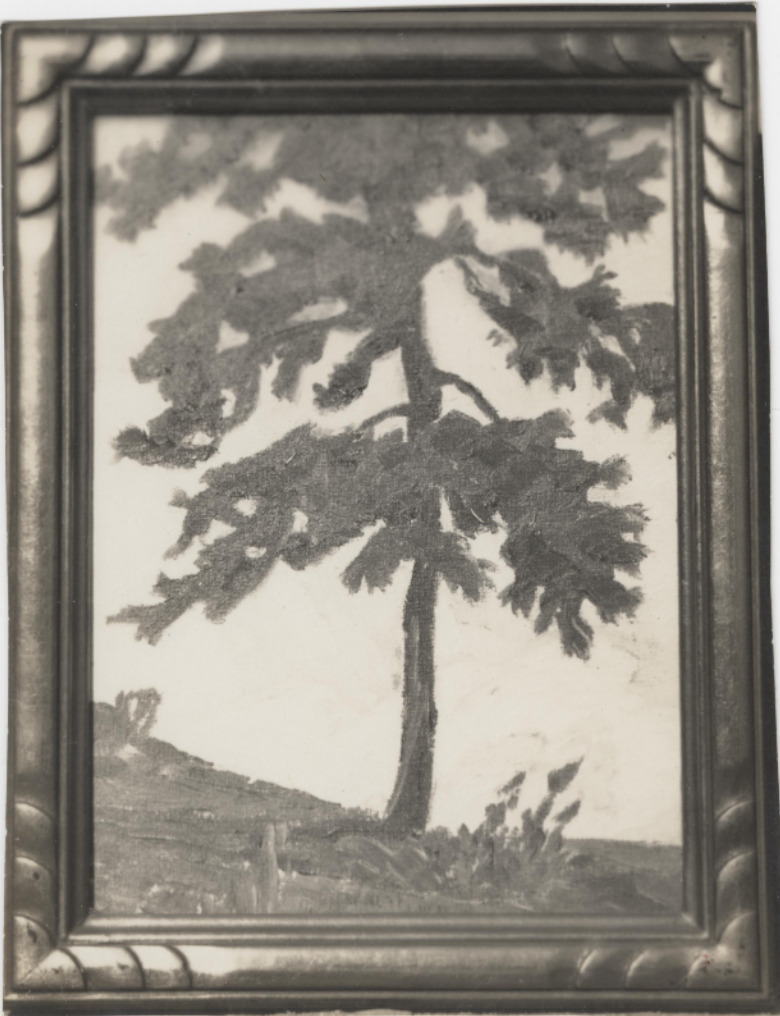
    <summary type="html"><![CDATA[<p><strong><em>Everett Ruess spent the latter half of that summer dancing with the Hopi, exploring the southern half of the Colorado Plateau, and eventually making his way from rim to rim of the Grand Canyon. He finally rested in Tropic, Utah before his final stop in civilization at Escalante, Utah.</em></strong></p><img src="https://www.intermountainhistories.org/files/fullsize/0ffdda85d33fb65d502b1812bba78b87.jpg" alt="Black and white photograph of Everett Ruess’ watercolor painting of a tree in the Colorado Plateau wilderness, ca. 1930s." /><br/><p><span style="font-weight:400;">Escalante, Utah, is a Mormon outpost founded in 1875, and named after Catholic Priest, Father Silvestre Vélez de Escalante. The town acted as a filter between the native lands to the southeast and the rest of the Mormon communities to the north. The town was all Mormon families, with most having the same last name and on average more than five children per family. Escalante’s residents followed the Mormon religion and morals since its founding sixty years prior to Everett’s arrival.</p> <span style="font-weight:400;">The vagabond who spent the last seven months living outdoors in the wilderness arrived in the Mormon town in early November 1934. Everett, a single male artist in a community of large agrarian families, immediately stood out like a sore thumb. He passed through the quaint town with his burros, Chocolatero and Cockelburro, and observed the Mormon church, its community members, and the many homes scattered throughout Escalante. Navajo traders had made their way into town occasionally to exchange with the community, but Escalante never saw a 20-year-old with two donkeys carrying watercolors, jewelry, and native rugs. Everett’s legendary status began here in 1934 due to his unique nature compared to the Mormon families, for the fact that he disappeared not far from here is the reason his myth still lives on in Utah. </span>
<span style="font-weight:400;">For the first time in five years of travel, Everett was financially stable, he had every reason to be satisfied with his life at this moment. He sent his parents ten dollars along with about twenty of his watercolor paintings. He told them to spend five dollars each on something that they “had been wishing to have,” so they proudly spent it to frame their son’s watercolors. In Escalante, Everett saw a film called </span><i><span style="font-weight:400;">Death Takes a Holiday</span></i><span style="font-weight:400;">, which is about death taking human form and asking the public why they fear death, a concept that Everett was fascinated by according to letters sent home. During these last moments in Escalante, Everett played the role of big brother to a lot of the children. According to letters sent from Escalante, he spent time “riding horses, hunting for arrowheads, and the like” with them. Everett’s role in Escalante was one of his most important ones as he served as a curiosity for not only the children but the community as a whole. Before he left, he wrote to his brother Waldo about his desire to stay out in the wilderness for an unknown period of time, for that is where he belonged.</span>
<span style="font-weight:400;">On November 12th, 1934, Everett left Escalante after chatting with the Alvey family who lived on the outskirts of town, and later recalled warning the young explorer of the conditions of the desert. His last winter excursion was in the Superstition Mountains near Phoenix, a completely different climate than southern Utah. A week later two sheepherders spotted him near Davis Gulch, Utah, and offered him mutton, but as the cool autumn air set over Escalante Canyon, Everett declined and was never seen again.</span></p><p><em><strong><a href="https://www.intermountainhistories.org/items/show/832">For more (including 5 images) view the original article</a></strong></em></p>]]></summary>
    <published>2024-05-25T04:26:23+00:00</published>
    <updated>2026-04-17T19:32:18+00:00</updated>
    <link rel="alternate" type="text/html" href="https://www.intermountainhistories.org/items/show/832"/>
    <id>https://www.intermountainhistories.org/items/show/832</id>
    <author>
      <name>Matthew T. Lankton, Northern Arizona University</name>
    </author>
  </entry>
  <entry>
    <title type="html"><![CDATA[The Beginning of the End: Kayenta, Arizona and Everett Ruess]]></title>
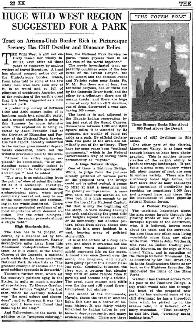
    <summary type="html"><![CDATA[<p><strong><em>On April 12th, 1934 Everett and his brother Waldo Ruess made the journey from southern California through the night. They stopped in Flagstaff for supplies, then headed north to Kayenta, Arizona, where Waldo dropped Everett off. It was the last time he was seen by anyone in his family.</em></strong></p><img src="https://www.intermountainhistories.org/files/fullsize/5132afc33e165a712d7a4a3391423c75.jpg" alt="New York Times, 1934" /><br/><p><span style="font-weight:400;">Known as the gateway to Monument Valley Navajo Tribal Park, Kayenta, Arizona lies in the Navajo Nation just south of the Arizona-Utah border. Kayenta was founded in 1909 by John Wetherill first as a trading post and eventually was established as a township by the Navajo Nation in 1962.</span>
<span style="font-weight:400;">After spending a semester at the University of California Los Angeles (UCLA) Everett traversed the Sierras in 1933. He made it clear to his brother, Waldo, that this journey in 1934 would be his last. After Waldo dropped him off, Everett spent the next two months exploring the region surrounding Kayenta. In a letter to Waldo, he wrote about his journey consisting of “Chin Lee [</span><i><span style="font-weight:400;">sic</span></i><span style="font-weight:400;">], Canyon de Chelly, the Luckachukais, and the Carrizos.” During this time Everett enjoyed the wilderness country, and experienced solitude, which he eventually achieved. During his third time in Canyon de Chelly, Everett foreshadowed his own fate when he wrote “I have been flirting pretty heavily with death” in a letter to a friend. Everett also stayed with Navajo families during this time, where he ate and hunted, making an impression that lasted generations.</span>
<span style="font-weight:400;">As the summer months approached, Everett recalled the crew of the Rainbow Bridge – Monument Valley archeological expedition near Kayenta. The expedition, funded by Ford Motor Company, aimed to provide field experience for explorers and survey the land for an attempted national park. He headed to the expedition’s camp near Skeleton Mesa, just west of Kayenta, and was hired by expedition leader Lyndon Hargrave of the Museum of Northern Arizona (MNA) in Flagstaff. He began working in exchange for meals, rather than the $3.50 a day that the other explorers received. He thoroughly enjoyed this experience because he could work alongside intelligent individuals, discuss the Navajo culture, draw and paint, climb any rock desired, and enjoy the wonders of nature with a sense of companionship for the first time.</span>
<span style="font-weight:400;">Hargrave recalled Everett’s skill from when they met briefly in 1931 at Mesa Ranch Schools’ summer camp. He assigned Everett to work under the crew of Clay Lockett, Flagstaff resident and ethnologist at MNA. The crew spent their time excavating Skeleton Mesa, specifically Woodchuck Cave, which contained archeological remains and objects from as far back as 200 C.E. During the expedition, Everett and  Lockett bonded over their love for art and nature. After his disappearance, Lockett later wrote, “I had an excellent chance to really know Everett,” demonstrating Everetts's lasting impression. It seemed that Everett made an impression on everyone he met, especially on this expedition.</span>
<span style="font-weight:400;">Everett displayed his love for adventure again when a storm approached the canyon, which encouraged him to capture the rolling clouds in watercolor as they encroached. The young vagabond displayed his risky personality while perched at the edge of the slick cliff, hunched over to protect the precious watercolor of Mother Nature in action. Everett soon finished the expedition, paused in Kayenta, and headed south to attend the Hopi snake dance one last time.</span></p><p><em><strong><a href="https://www.intermountainhistories.org/items/show/831">For more (including 4 images) view the original article</a></strong></em></p>]]></summary>
    <published>2024-05-25T04:12:43+00:00</published>
    <updated>2026-04-17T19:32:18+00:00</updated>
    <link rel="alternate" type="text/html" href="https://www.intermountainhistories.org/items/show/831"/>
    <id>https://www.intermountainhistories.org/items/show/831</id>
    <author>
      <name>Matthew T. Lankton, Northern Arizona University</name>
    </author>
  </entry>
  <entry>
    <title type="html"><![CDATA[Everett Ruess in Navajo Country and Canyon de Chelly National Monument ]]></title>
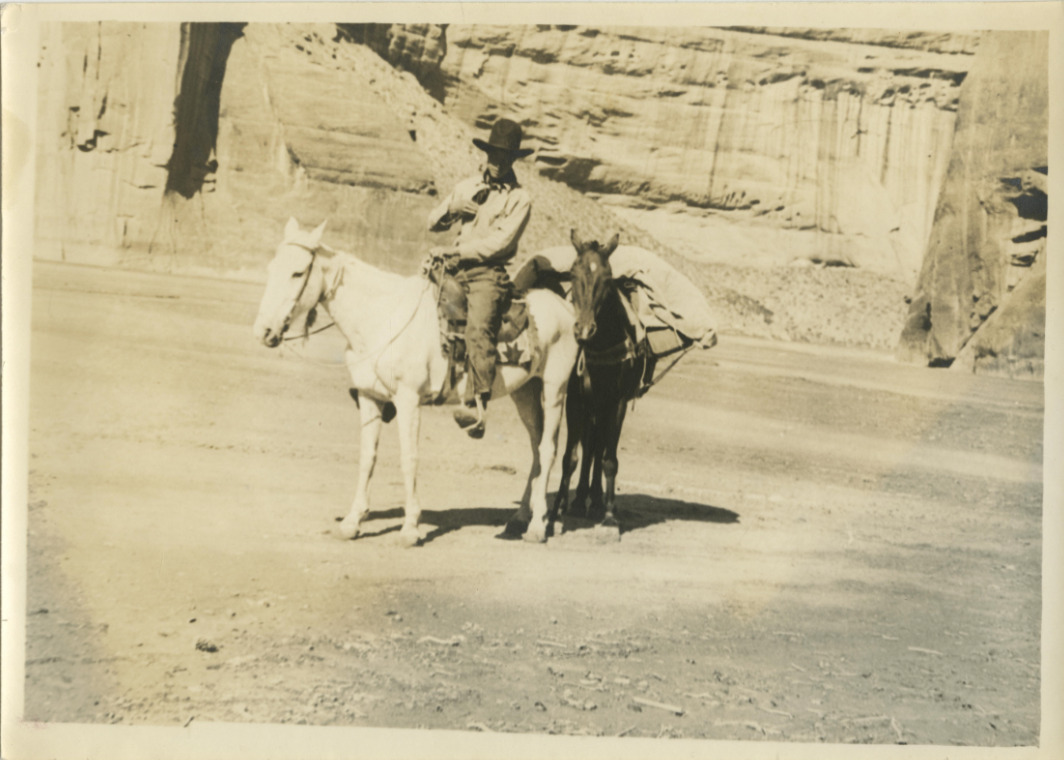
    <summary type="html"><![CDATA[<p><strong><em>In 1932 Everett Ruess set out to central Arizona where he enjoyed the mountainous desert, and later began his journey to his beloved northern Arizona wilderness.</em></strong></p><img src="https://www.intermountainhistories.org/files/fullsize/0dcf36256a9e8c5f10ae900bf7f4e951.jpg" alt="Everett and his horses, 1932" /><br/><p><span style="font-weight:400;">Canyon de Chelly (d’`SHAY) is located in the Navajo Nation and contains the architecture, artifacts, and culture of the communities that have lived there for millennia. Archeologists believe the canyon first had residents roughly 5,000 years ago with the Archaic people. The canyon contains the iconic Spider Rock, White House Ruins, and petroglyphs, and was established as a national monument in 1931 by former President Herbert Hoover. A tributary of Canyon de Chelly is Canyon del Muerto (</span><i><span style="font-weight:400;">Canyon of Death</span></i><span style="font-weight:400;">), named after prehistoric native burials found by the Smithsonian in the canyon in the late nineteenth century. The canyon serves as a monument of the native population, as well as their resilience in defending their sacred land from European settlers.</span>
<span style="font-weight:400;">Everett began his 1932 journey in central Arizona, making his way up to the Mogollon Rim, and eventually Chinle, Arizona, just west of Canyon de Chelly National Monument. Everett had been here just one year prior, before he eventually stayed in Flagstaff and the Grand Canyon, then headed back to southern California. On July 12th, the day before entering Canyon de Chelly, he wrote a lengthy letter to his brother Waldo expressing his appreciation for the outdoors and his belief that “there can be no other life for me but that of the lone wilderness wanderer.” </span>
<span style="font-weight:400;">The next morning, Everett wrote that he went “over the hill to Canyon de Chelly, their [Navajo] homeland.” The canyon welcomed Everett with powerful winds, stalling his progress. As he made his way East through Canyon del Muerto, he passed by the White House Ruin and noted the “tall monument” of Spider Rock in his journal. Everett made the journey back from the belly of de Chelly to Canyon del Muerto, where he noted the lack of water. As he had been in the canyon before in 1931, the towering walls of the canyon and the winds that del Muerto presented were very familiar. In roughly four days Everett made his way up through Canyon del Muerto with his horses Nulfo and Jonathan. The trail out of the canyon was not easy for them. He noted that Jonathan was hobbling in circles before eventually collapsing to the ground beneath him, and noting that the place really was the Canyon of Death for “gentle old Jonathan.”</span>
<span style="font-weight:400;">Everett emerged from Canyon de Chelly National Monument with Nulfo by his side, heading toward their next journey to Mesa Verde in Colorado. He remained here for about another month until hitchhiking his way back to Los Angeles where he began a semester at the University of California Los Angeles (UCLA). Despite the remarkable characteristics of his journey, he was still a human who experienced indecision like any other eighteen-year-old. While at UCLA, Everett reminisced on his time at Canyon de Chelly and the rest of the region which provoked him to write a letter explaining that he did not belong in college, but rather in the wilderness which he returned to a few months later.</span></p><p><em><strong><a href="https://www.intermountainhistories.org/items/show/830">For more (including 5 images) view the original article</a></strong></em></p>]]></summary>
    <published>2024-05-25T03:51:26+00:00</published>
    <updated>2026-04-17T19:32:18+00:00</updated>
    <link rel="alternate" type="text/html" href="https://www.intermountainhistories.org/items/show/830"/>
    <id>https://www.intermountainhistories.org/items/show/830</id>
    <author>
      <name>Matthew T. Lankton</name>
    </author>
  </entry>
  <entry>
    <title type="html"><![CDATA[Indigenous People of Bryce Canyon]]></title>
    <summary type="html"><![CDATA[<p><strong><em><span style="font-weight:400;">The place known today by millions of people as Bryce Canyon National Park has been known by different names to many other people over centuries. The history of those who have journeyed along the canyon before paths were paved there still have a deep connection to the land. And over the past century, an increasing number of people admire the beauty and appreciate such a connection.</span></em></strong></p><img src="https://www.intermountainhistories.org/files/fullsize/83f8b3ce41456cf4cf8fa80c55f1fc6d.jpg" alt="[Untitled]" /><br/><p><span style="font-weight:400;">Unka tumpee wun-nurrx tungwatsini xoopakichu ahnax, Sikyaatutukwi, Bios to chi bi kool, Angka-ku-wass-a-wits, Bryce’s Canyon. </p><p>These are the former names of the geographic marvel now known as Bryce Canyon National Park. Southern Paiutes, Hopi, Zuni, Ute, and Navajo tribes all lived in this region and enjoyed its natural beauty and wonders. Even before these nations, other ancient peoples lived here for centuries. The Indian names, meaning “place of yellow points,” “red painted faces,” and “red rock standing like a man in a hole,” come from ancient legends of the rock formations now called “hoodoos,” meaning scary or a bad omen. Some claimed that the hoodoos were once people who had been turned to stone. This incredible landscape provided a place for indigenous peoples to hunt and gather grass seeds and other foods, creating a deep connection with the land. </span>
<span style="font-weight:400;">Sadly, from 1850 to 1890, through various laws, acts, and atrocities, Native Americans were forced from Bryce Canyon, some to distant reservations. Those that were far removed from Bryce Canyon, like the Navajo, remembered its beauty through oral histories. The Paiutes were not driven out until about 1880, five years after LDS Scottish Rancher Ebenezer Bryce settled there. From the turn of the century onward, new people began coming into the area to settle or sight-see. In 1916, with help from the Union Pacific Railroad, lodges and rest stations began to be built, providing a place for visitors to stay. In 1923, Bryce Canyon became a National Monument and in 1928 it became a National Park, with the boundaries expanded in 1931 and again in 1942. In 1934 workers of the Civilian Conservation Corps created much of the infrastructure that helped make Bryce Canyon more accessible to the public. Today this beautiful National Park is visited by over 1.5 million people annually.</span>
<span style="font-weight:400;">Though this park is now accessible to many people, the indigenous nations that once lived there still have a great connection to the land through their histories and traditions. In past decades most members of those nations lack the resources needed to visit Bryce Canyon, though more indigenous people are able to visit these sacred sites today. They continue to pass on the traditions and stories to new generations. Some Paiutes have returned to the area and still live nearby. Dozens of people currently reside within Bryce Canyon's lands. Leigh Kuwanwisiwma, a member of the Hopi Tribe, teaches “This is our heaven. This is the human people’s heaven, and we need to appreciate that.” A sacred place to many tribes, and now a nationally protected park, Bryce Canyon deserves respect and reverence as visitors admire its wonders.</span></p><p><em><strong><a href="https://www.intermountainhistories.org/items/show/787">For more (including 3 images) view the original article</a></strong></em></p>]]></summary>
    <published>2024-03-01T23:35:49+00:00</published>
    <updated>2026-04-17T19:32:17+00:00</updated>
    <link rel="alternate" type="text/html" href="https://www.intermountainhistories.org/items/show/787"/>
    <id>https://www.intermountainhistories.org/items/show/787</id>
    <author>
      <name>Rachel Feilbach, Brigham Young University</name>
    </author>
  </entry>
  <entry>
    <title type="html"><![CDATA[The Unresolved Legacy of Intermountain Indian Boarding School]]></title>
    <summary type="html"><![CDATA[<p><strong><em><span style="font-weight:400;"> Indian boarding schools throughout the United States and Canada have reputations of  discrimination and immorality. Intermountain Indian Boarding School in Utah had a history of  scandal and struggle yet its student body largely remained positive concerning its influence, thus  separating it from traditional Indian boarding schools.  </span></em></strong></p><img src="https://www.intermountainhistories.org/files/fullsize/cb821297eb0d9723572cbb6fd67c0423.jpg" alt="Students in English Class at Intermountain" /><br/><p><span style="font-weight:400;">In January 1950, Intermountain Indian Boarding School in Brigham City, Utah was established. In its first year, the school welcomed around 500 Navajo students. Twenty-four years later, in 1974, Intermountain opened its doors to students from nations outside of the Navajo and remained inter-tribal until it closed in 1984. In comparison with other Indian boarding schools in the United States and Canada, the Intermountain Indian Boarding School has a fairly tame reputation; however, many public controversies and struggles throughout the school’s history leave its legacy complex and unresolved.  </span>
<span style="font-weight:400;">Yearbooks from Intermountain paint student experiences in a positive, culturally enriching light. Pages are rife with statements such as “at Intermountain, students retain their proud heritage and also find delight in new events - blending both elements into a rich and an unforgettable year.” Interviews with students ring with similar sentiments such as: “I really enjoyed the situation because it brought me away from a home where we had to haul water and no running water and all that stuff and everything was furnished.”  </span>
<span style="font-weight:400;">Nevertheless, even though the student body projected love for their school, some instances in the school’s history indicate an alternative view. In early 1972, a student from Intermountain committed suicide while being held in Brigham City Jail. This was the second suicide of an Intermountain student, the first of which occurred four years previous in November 1968. Regarding the second suicide, Intermountain officials released a statement stating that they had “nothing to hide.” Additionally, between these two suicides, in April 1971, a group of students filed a lawsuit against the school and its administrators on the grounds of segregation, discrimination, and the use of tranquilizers, among other things. Ultimately the court ruled in favor of the school. </span>
W<span style="font-weight:400;">hen discussions of the school's closing began, students made public demonstrations against imminent closure by running on foot for over 20 miles.</span> Without success, Intermountain Indian Boarding school closed in 1984, to the devastation of some. The legacy of the school remains complicated as its history combines tragedy and opposition in the midst of tolerance and benevolence. </p><p><em><strong><a href="https://www.intermountainhistories.org/items/show/645">For more (including 5 images) view the original article</a></strong></em></p>]]></summary>
    <published>2022-09-12T16:36:08+00:00</published>
    <updated>2026-04-17T19:32:14+00:00</updated>
    <link rel="alternate" type="text/html" href="https://www.intermountainhistories.org/items/show/645"/>
    <id>https://www.intermountainhistories.org/items/show/645</id>
    <author>
      <name>Emma Barlow, Brigham Young University</name>
    </author>
  </entry>
  <entry>
    <title type="html"><![CDATA[Newspaper Rock]]></title>
    <summary type="html"><![CDATA[<p><strong><em>One of many petroglyph sites in Utah, Newspaper Rock is unique because of the large time span in which the petroglyphs were drawn. It is a look into the past lives of those who lived in Utah before us.</em></strong></p><img src="https://www.intermountainhistories.org/files/fullsize/503ebfadc22176964ceb07658bf0b8f0.jpg" alt="Newspaper Rock" /><br/><p>Newspaper Rock is located along the Scenic Creek Corridor Scenic Byway in the Bears Ears National Monument, created on the cliffs that go through all of Indian Creek Canyon. Newspaper Rock is about 24 miles northwest of Monticello and 50 miles south of Moab. The actual petroglyph site is around 200 square feet across. It is located along the main road to the Needles District of Canyonlands National Park. There is no fee to access this site, and it is open all year long. Formerly a state park, Newspaper Rock currently carries the designation of a National Monument.</p><p>The petroglyphs that cover the group of rocks collectively known as Newspaper Rock were drawn across a wide span of time ranging from 1200 to 200 years ago. The petroglyphs are thought to be drawn by a variety of people including the Ancestral Pueblo, Fremont, Basket Maker, and Navajo peoples.</p><p><span>As a hunter-gather people living around 100 CE, Ancestral Puebloans’ diet relied upon hunting. Later, they transitioned to a sedentary lifestyle and relied more upon agriculture. They occupied the southwest area of the modern-day United States until droughts destroyed their agricultural economy and forced them to move away from Utah, Arizona, Colorado, and New Mexico to other areas with more water. The Fremont also inhabited this area around the same time as the Ancestral Puebloans. Similarly, they developed agricultural practices, but hunting remained an important part of their culture until devastating droughts hit the region. By the fifteenth century, the Diné (Navajo) arrived and, like their predecessors, participated in hunting and gathering. When the Diné moved into the southwest, they adapted some of the Puebloans’ agricultural practices and cultivated corn, beans, and squash while supplementing their diet through hunting.</span></p><p><span>The Ancestral Puebloans, Fremont, and Navajos all added carvings to this rock</span> over the course of centuries. As a result, there is no linear story that can be understood from the pictures. Most of the pictures remain unidentified and uninterpreted because there is no way to discover their meaning. It is unclear why this particular rock was such a popular place for petroglyphs, but its popularity in the ancient world has made it popular again in the modern world. <span>European explorers added more names and dates, and</span> curious visitors come to see the pictures etched by ancient peoples long past.</p><p>In the Navajo language, Newspaper Rock is called <em>Tse’ Hane</em>, which means, “rock that tells a story.” What do these ancient storytellers reveal about the Native American Indians who created These mysterious images? Though there is no exact translation known for many of these petroglyphs, it is possible to infer some things about the people from their rock art. These markings, engravings, and drawings tell us about stories, hunting patterns, crop cycles, beliefs, and mythologies of their existence. Some modern Native American Indians have interpreted the drawings on the rock to include family or clan symbols, spiritual meanings, and calendar events. Images include those of animals, people, tools, and other items. We know that the drawings were compiled over time by different groups who were in the area. Earlier drawings resemble snakes, wagon wheels, lizards, footprints, and broad shouldered, animal headed people. Some we can tell were made later, depicting men on horseback, potentially referring to the coming of the Spanish and other colonizers who threatened some groups and brought prosperity to others. These petroglyphs help us add to the tales we already know about these ancient people as we build on the foundation of what we know about them from other artifacts and oral histories.</p><p><em><strong><a href="https://www.intermountainhistories.org/items/show/564">For more (including 6 images) view the original article</a></strong></em></p>]]></summary>
    <published>2021-12-18T08:33:05+00:00</published>
    <updated>2026-04-17T19:32:12+00:00</updated>
    <link rel="alternate" type="text/html" href="https://www.intermountainhistories.org/items/show/564"/>
    <id>https://www.intermountainhistories.org/items/show/564</id>
    <author>
      <name>Sarah Taylor, Sarah McCuen, Emma McLeod Lariviere, and C. Raquel Rawlings, Brigham Young University</name>
    </author>
  </entry>
  <entry>
    <title type="html"><![CDATA[Phoenix Indian School: Spirits Unbroken by Colonization]]></title>
    <summary type="html"><![CDATA[<p><strong><em>In March 1819, Congress passed the Indian Civilization Act, which placed native children into boarding schools in order to "civilize" and Christianize them.</em></strong></p><img src="https://www.intermountainhistories.org/files/fullsize/ceffbfbdee1b3db5775e82f665578827.jpg" alt="Phoenix Indian Boarding School" /><br/><p>In March 1819, Congress passed the Indian Civilization Act with the purpose of civilizing and Christianizing Native peoples in an effort to, in the words of Captain Richard Pratt, “kill the Indian and save the man.” Administrators established Indian boarding schools across the United States, designing them to assimilate Native American youth to Western culture and ideals. The National Native American Boarding School Healing Coalition explains that indigenous children at Indian boarding schools were “banned from acting in a way that might be seen to represent traditional or cultural practices, stripped of traditional clothing, long hair, personal belongings, and behaviors reflective of their Native culture. They suffered physical, sexual, cultural, spiritual abuse, neglect, and experienced treatment that in many cases constituted torture for speaking their Native languages.” These acts were covered up though, creating a false pretense of helping others due to misunderstood prejudices.
Students from these boarding schools harbored a deep resentment towards the forced assimilation. Euro-American administrators and designers hoped the education could make indigenous students give up their own cultures and think like "white" Americans, thereby "becoming" "white." However, students realized they controlled whether or not the schools could truly indoctrinate them with white culture. Many student actions and behaviors sent a message that they could not, and would not, participate in the genocide of their culture. The success of their resistance is primarily attributed to their ability and desire to band together to preserve cultural identity, which was a common practice in most native tribes; the freedom of community was placed above freedom of the individual.
Dodésbaáh was one of many thousands of young children who endured trauma at the Phoenix Indian Boarding School, fought the system, and survived. She endured physical, mental, and emotional abuse at the hands at teachers and administrators. She determinedly retained her Navajo language and name, refusing to accept the name of "Sadie" the school attempted to force on her. She frequently ran away from the boarding school, and her overall defiance landed her in constant trouble with school authorities. When she had children of her own, she refused to send them to experience the same pain and suffering she did as a young girl. Dodésbaáh passed away in 2001 at the age of 100, surrounded by four generations of descendants. Her strong spirit and the importance of family, religion, tradition, and culture were in the room with her as she looked into the eyes of her posterity.
The attempted cultural genocide of indigenous peoples and the mission of federal boarding school systems failed. The strength of Native peoples who resisted forced assimilation continues today as they fight for land rights, water rights, and the right to retain their culture, identity, and history. The spirit of Native communities is laced with a distinctive beauty that encourages those who hold a deep sense of pride in their Native heritage to maintain a legacy of embracing their heritage and unified strength.</p><p><em><strong><a href="https://www.intermountainhistories.org/items/show/484">For more (including 4 images) view the original article</a></strong></em></p>]]></summary>
    <published>2021-09-15T07:10:13+00:00</published>
    <updated>2026-04-17T19:32:10+00:00</updated>
    <link rel="alternate" type="text/html" href="https://www.intermountainhistories.org/items/show/484"/>
    <id>https://www.intermountainhistories.org/items/show/484</id>
    <author>
      <name>Kirsten Larcade, Brigham Young University</name>
    </author>
  </entry>
  <entry>
    <title type="html"><![CDATA[Navajo Code Talker Monument]]></title>
    <summary type="html"><![CDATA[<p><strong><em>This monument honors the Navajo young men who used their Native language on behalf of the United States of America to transmit coded messages during World War II. Their contributions proved to many the importance and value of preserving native culture.</em></strong></p><img src="https://www.intermountainhistories.org/files/fullsize/c32297ab11f821ec3c0e513dc1a57bfe.jpg" alt="Navajo Code Talker Memorial" /><br/><p>Early in World War II, the Japanese managed to break every military code transmitted throughout the Pacific Ocean. As a result, U.S. military officials wrestled with the problem of creating an unbreakable code. After the failure of many pilot programs featuring various native tongues, Philip Johnston suggested the Navajo language. Johnston grew up on the Navajo reservation with his missionary family and was one of the few non-Navajos to fluently speak the language. Johnston encouraged the United States Marine Corps to involve the Navajos and supported the development of the Navajo Code Talker program.</p><p>The pronunciation and specific use of words in the Navajo language is fundamentally impossible to master as an adult. Many descriptive words sound the same and are only differentiated by an exchange of tone; this aspect of the Navajo language ensured a protected transference and translation of a message to its target. In 1940, fewer than thirty people outside the Navajo tribe knew the language, and the isolation of the Navajo reservation helped preserve its exclusivity. </p><p>Prior to World War II and directed by government treaties, many Navajo children attended boarding schools near the reservation, learned English, and were forbidden to use the Navajo language. Although an unplanned benefit, minimizing the use of this native language meant that very few people knew or spoke it, an effect that persuaded the Marine Corps to recruit young Navajos to serve in areas throughout the Pacific Ocean during the war. These young men learned how to use their language as a code for use in combat procedures. As the first 29 Navajo recruits completed bootcamp, they began developing the combat code at Camp Elliot. The unique nature of this descriptive yet ambiguous language made it unbreakable. The Navajo Code Talkers succeeded so well at transmitting and interpreting messages that even U.S. cryptographers could not understand the code, successfully frustrating Japanese translation efforts. The United States accomplished a favorable victory during World War II with the help of the Navajo Code Talkers.   </p><p>The young men who participated as Navajo Code Talkers honored the Navajo Nation by responding to the need of the United States and completing the required responsibility. The account of their achievements remained secret for decades after World War II due to the government’s confidential policies. In the late 1960s, the United States declassified the topic of the Navajo Code, which allowed Navajo Code Talkers to share their experiences with their families and the nation. In 2010, famous Navajo Ute sculptor Oreland Joe designed and erected the Navajo Code Talker Monument near Window Rock, Arizona. It serves as a tribute to the Navajo Code Talkers who sacrificed and secured victory for the United States. </p><p><em><strong><a href="https://www.intermountainhistories.org/items/show/405">For more (including 3 images) view the original article</a></strong></em></p>]]></summary>
    <published>2020-03-11T23:49:29+00:00</published>
    <updated>2026-04-17T19:32:08+00:00</updated>
    <link rel="alternate" type="text/html" href="https://www.intermountainhistories.org/items/show/405"/>
    <id>https://www.intermountainhistories.org/items/show/405</id>
    <author>
      <name>Crystal Stewart, Brigham Young University</name>
    </author>
  </entry>
  <entry>
    <title type="html"><![CDATA[Uranium Mining on the Navajo Reservation]]></title>
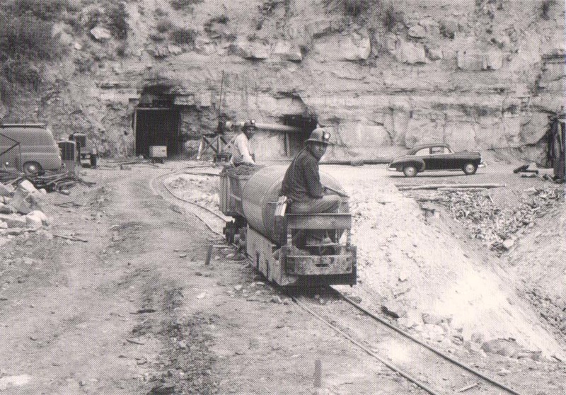
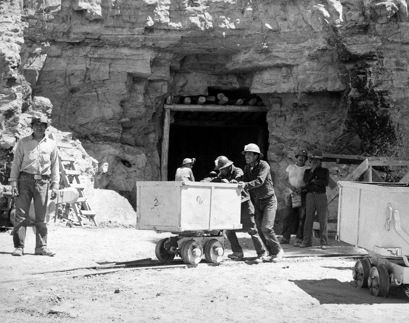
    <summary type="html"><![CDATA[<p><strong><em>The mining of uranium on the Navajo Reservation at the numerous Kerr-McGee mines aided weapon development during the Cold War. For many Navajo miners, this mining also exposed them to harmful radiation.</em></strong></p><img src="https://www.intermountainhistories.org/files/fullsize/1b04369a7d813bd703c61eb424a5f89d.jpg" alt="Navajo miners near Cove, Arizona in 1952" /><br/><p>After the conclusion of World War II, uranium ore was discovered in Northeast Arizona in the Lukachukai Mountains near the towns of Cove and Red Valley , Arizona. The Kerr-McGee Corporation started mining operations in 1952 in the Red Valley area by opening the Cove and Mesa mines on the Navajo Reservation. These uranium digs helped fuel the nuclear Arms Race between the United States and the Soviet Union during the 1950s and 1960s. Unlike other mines in Arizona, however, mining here proved more difficult since this uranium ore had formed in irregular and thin layers. The corporation used manual labor, employing mostly Navajo people, instead of machines to crush the stone. This crushed ore resembled a yellow chalk that could then undergo a refining process to extract the uranium. </p><p>This type of mining produced critically contaminated air, filling the mine shafts with radioactive uranium dust, radon gas, and superfine silica. Smaller mines in particular lacked proper ventilation systems to remove or filter air, and as a result, workers inhaled these chemicals constantly. Many miners developed health complications ranging from damaged lungs to cancer due to lack of knowledge about the long-term effects of radiation as well as inadequate protective equipment. </p><p>Mining operations peaked in 1955 and 1956 with the fervor of the Cold War, but two decades later in 1967, all uranium mining ceased. The fatalities that occurred from mining efforts, in addition to lingering health problems, left their mark on the history of uranium mining; its legacy of damaged lives and environmental landscapes eventually resulted in government action. Congress passed the Radiation Exposure Compensation Act (RECA) in 1990 to compensate those affected by nuclear or radioactive exposure. Uranium miners and ore transporters, among them many Navajos, received the largest compensation of $100,000. While monetary compensation cannot reverse the consequences of uranium mining, RECA demonstrates the cooperation between the U.S. government and the Navajo Reservation.</p><p><em><strong><a href="https://www.intermountainhistories.org/items/show/402">For more (including 3 images) view the original article</a></strong></em></p>]]></summary>
    <published>2020-03-08T05:33:53+00:00</published>
    <updated>2026-04-17T19:32:08+00:00</updated>
    <link rel="alternate" type="text/html" href="https://www.intermountainhistories.org/items/show/402"/>
    <id>https://www.intermountainhistories.org/items/show/402</id>
    <author>
      <name>Kee Ranger, Brigham Young University</name>
    </author>
  </entry>
  <entry>
    <title type="html"><![CDATA[AIM Occupation of Fairchild Plant on Navajo Reservation]]></title>
    <summary type="html"><![CDATA[<p><strong><em>Activism plays a significant role in improving employment quality and longevity, but situations like the occupation of the Fairchild Plant on the Navajo Reservation causes people to question whether or not activism is the best method to achieve such goals.</em></strong></p><img src="https://www.intermountainhistories.org/files/fullsize/f881a04cf0a41c0bb4ee8d31723f525d.jpg" alt="Ribbon cutting at Fairchild Building Dedication, 1969" /><br/><p>In the early 1960s, unemployment on the Navajo Reservation hovered around 40% and Tribal leadership desperately tried to create jobs for Diné peoples. In 1964, Tribal chairman Raymond Nakai advocated for better economic development on the reservation and – hoping to attract outside investment – opened up the Navajo Nation to outside businesses. To further entice companies, the tribe offered $1 million toward development to any company willing to relocate. Fairchild Camera and Instrument Corporation responded to the offer and decided to build a plant in Shiprock, New Mexico and provide housing for tribal members who helped with construction. After its completion, Fairchild employed more than a thousand workers (the majority being female) and provided consistent jobs for ten years. </p><p>In the early 1970s, however, the country’s economy lagged, affecting companies like Fairchild. Many of the workers in Shiprock faced reduced paychecks or even termination. According to one Navajo account, the plant manager said, “This is a business venture, not a charitable activity.” The weakened economy combined with news of the plant’s financial solution wounded the community’s morale. The American Indian Movement (AIM) – an organization founded during the Civil Rights Era that fought for indigenous communities’ rights – heard about the situation and decided to intervene. Protestors including activist Russell Means came to Shiprock and laid siege to the plant on behalf of the underpaid and dismissed workers. The protestors demanded that Fairchild rehire the workers and restore their paychecks to pre-reduction rates. However, some local Natives considered this protest against the company dangerous and unnecessary. </p><p>Fairchild refused AIM’s conditions and let the tribal government handle the matter. However, the tribal government did not help overcome the impasse and the siege ultimately shut down the plant. Fairchild executives expressed frustration over how the tribe handled the situation and withdrew from the reservation altogether, relocating their operations to Korea. Some AIM supporters perceived this result as a victory, but locals recognized the great loss of employment opportunity alongside a damaged reputation for future incoming businesses on the Navajo Reservation. Even today, these consequential outcomes continue to have a harmful effect on Navajo employment.</p><p><em><strong><a href="https://www.intermountainhistories.org/items/show/398">For more (including 3 images) view the original article</a></strong></em></p>]]></summary>
    <published>2020-03-06T23:38:51+00:00</published>
    <updated>2026-04-17T19:32:08+00:00</updated>
    <link rel="alternate" type="text/html" href="https://www.intermountainhistories.org/items/show/398"/>
    <id>https://www.intermountainhistories.org/items/show/398</id>
    <author>
      <name>Elias Gold, Brigham Young University</name>
    </author>
  </entry>
  <entry>
    <title type="html"><![CDATA[Kit Carson’s 1864 Interactions with Navajos]]></title>
    <summary type="html"><![CDATA[<p><strong><em>Kit Carson’s siege of Canyon de Chelly led to the Long Walk relocation of the Navajo peoples. Having since returned to their homeland, the Navajos have proved their endurance through conquest and cultural genocide.</em></strong></p><img src="https://www.intermountainhistories.org/files/fullsize/8a4e53e9ca09e9d130768a68addeb683.jpg" alt="Navajo on Long Walk" /><br/><p>The natural fortress of Canyon de Chelly in modern-day Arizona housed was one of the largest gatherings of Navajo, or Diné, people. The area supported many family communities and contained plentiful resources. Early explorers even considered Canyon de Chelly a dangerous area because of the enormous Navajo population. However, as immigrants moved west in the early nineteenth century, the Navajos faced oppression from settlers and United States military forces. By the 1860s, the Navajos had encountered these groups on multiple occasions and frequently negotiated trade, land inquiry, and intertribal relations. </p><p>Indian agent Christopher “Kit” Carson primarily handled dealings between the federal government and Navajo people. The U.S. government authorized a campaign of total warfare against the Navajos to limit their independence and force their removal from the territory. Kit Carson was instructed to lead attacks against various communities of Navajo families and, in 1864, accomplished this goal by cutting off natural resources, exterminating food and shelter, gathering the Navajos together and communally leading them away from their traditional homelands, and incarcerating opposing forces. </p><p>Skirmishes and confrontations between the two parties led to the largest tribal surrender in American history. After a month of conflict, Kit Carson and his armies initiated the Navajo Long Walk, a 250-450-mile journey from their homeland to internment camps at Bosque Redondo in New Mexico.  </p><p>The Long Walk remains a defining moment in Diné history. Navajo war leaders and federal government authorities such as William T. Sherman convened to negotiate the future of the relocated Navajo people. The Navajo Treaty of 1868 allowed survivors to return to their traditional homelands and start over. The destruction at Canyon de Chelly and the subsequent removal caused permanent damage to Navajo family structures and instigated a gradual cultural genocide. Despite their significant losses of population, the Navajo people have managed to withstand the legacy of conquest by preserving their culture and homeland. The Navajos are the largest group of American Indians today.</p><p><em><strong><a href="https://www.intermountainhistories.org/items/show/394">For more (including 4 images) view the original article</a></strong></em></p>]]></summary>
    <published>2020-03-02T22:52:45+00:00</published>
    <updated>2026-04-17T19:32:07+00:00</updated>
    <link rel="alternate" type="text/html" href="https://www.intermountainhistories.org/items/show/394"/>
    <id>https://www.intermountainhistories.org/items/show/394</id>
    <author>
      <name>Sheiyenne Baloo, Brigham Young University</name>
    </author>
  </entry>
  <entry>
    <title type="html"><![CDATA[The Navajo Trail of Tears from Fort Defiance to Bosque Redondo]]></title>
    <summary type="html"><![CDATA[<img src="https://www.intermountainhistories.org/files/fullsize/0fcb145b9ba89e523a3cc8089c2d528f.jpg" alt="Navajos Under Guard After Forced March to Fort Sumner, New Mexico, ca. 1864" /><br/><p>The Long Walk is to the Navajo what the Trail of Tears is to the Cherokee. Troubled relations between the U.S. and the Navajos brought on a wicked removal in December of 1863. Earlier in the year, the United States government had sent in Christopher “Kit” Carson to remove the Navajos from their homeland of Fort Sumner, New Mexico. He burned their villages, starved them, and took them as slaves until they surrendered in the middle of winter, the worst time to begin a 400+ mile journey from points in Navajo country to Fort Defiance, Arizona and from there to Fort Sumner, New Mexico.</p><p>Cold made the difficult journey worse, but the Navajos suffered the most spiritually and mentally because they were uprooted from their homeland. They called their home The Four Sacred Mountains due to the spiritual qualities it possessed for them. Their hardships resulted in the death of around 200 Navajos on the journey. Some died from their conditions. Others were shot for being pregnant, old, or slow. The Navajos were not allowed to bury their dead.</p><p>More than 8,000 Navajos made it to Fort Sumner where they experienced continued starvation, slavery, prostitution, and disease at the hands of their enemy. It is estimated that more than 3,000 Navajos died at Fort Sumner by 1868. That spring, General Sherman of the United States of America sent a survey report back to the government and reported only 7,111 Navajo survived at Fort Defiance, and that he was convinced, “that the Navajos [would] never be contented to remain” at any place other than their homeland. On August 28, President Andrew Johnson signed a treaty that allowed the Navajo to return to their home at Fort Defiance.</p><p>One Navajo woman said, “When I tell my grandchildren about the Long Walk, they don’t believe me. I tell them that they wouldn’t be as they are today if their ancestors hadn’t gone through the confinement and even died of hunger.” The Navajos are proud of their ancestors for being strong and surviving against the odds. They recognize that this type of horrible event should never happen again.</p><p><em><strong><a href="https://www.intermountainhistories.org/items/show/191">For more (including 3 images) view the original article</a></strong></em></p>]]></summary>
    <published>2018-05-31T00:31:34+00:00</published>
    <updated>2026-04-17T19:32:02+00:00</updated>
    <link rel="alternate" type="text/html" href="https://www.intermountainhistories.org/items/show/191"/>
    <id>https://www.intermountainhistories.org/items/show/191</id>
    <author>
      <name>Maddie Pettit, Brigham Young University</name>
    </author>
  </entry>
  <entry>
    <title type="html"><![CDATA[Navajo Long Walk to Bosque Redondo]]></title>
    <summary type="html"><![CDATA[<p><strong><em>The forced relocation of Navajo to Fort Sumner in the 1860s was a time of loss and sorrow. The United States government was unable to support the large number of people forced out of their homes. </em></strong></p><img src="https://www.intermountainhistories.org/files/fullsize/14772910caae170413410284c32f8787.jpg" alt="[Untitled]" /><br/><p>From 1864 to 1868, the Navajos were forced to live at Fort Sumner on the Bosque Redondo reservation in eastern New Mexico, approximately 300 miles from their homeland. Around 8,000 Navajos were forced to make the journey. Hundreds, including the elderly and children, died on the way. Many more died during the four years at Bosque Redondo. </p><p>Navajo homelands cover northeast Arizona, northwest New Mexico, southeast Utah, and southwest Colorado. Their home, which they call Dinétah, is bordered by the four sacred mountains. Leading up to the Long Walk, the Navajos had difficult relations with the United States Army. This included broken treaties, the Army not protecting the Navajos from other raiding tribes, and some Navajos raiding the soldiers. Because of these raids, the military leader of New Mexico, James H. Carleton, wanted to control the Navajos. Carleton’s other motives were to assimilate the Navajos into an agricultural and Christian lifestyle. He also wanted their land for silver and gold mining. He gave the Navajos a chance to surrender but none did. He received help from Christopher “Kit” Carson, who eventually got the Navajos to abandon their land after burning and destroying everything they had. The majority surrendered, but others hid from and fought the soldiers. </p><p>In spring of 1864, the Navajos were forced to journey to Bosque Redondo. They did not know where they were going, how far they would travel, or how long the trip would last. They were not prepared for such a journey. Those who could not keep up were left behind. Fort Sumner was not big enough for the large number of Navajos plus the Mescalero Apaches that were also relocated there. Inadequate amounts of food and supplies caused near starvation. When they were given food, it was spoiled or they did not know how to prepare it. Crops that the Navajos grew failed greatly each year. Carleton’s experiment was unsuccessful.</p><p>On June 1, 1868, the Treaty of Bosque Redondo was signed by the United States Government and Navajo leaders. The treaty allowed them to return to their traditional homeland. They were granted “$150,000 for rehabilitation, plus 15,000 sheep and goats and 500 head of cattle, as well as token payments to each tribal member.” Part of the treaty included sending the children and future generations to government boarding schools where their cultural identity was stripped from them. The last of these schools closed in the 1980s.</p><p>The tragedy of the Long Walk is still evident in the culture and attitudes of the Navajo. While it is difficult for them to reflect upon, they remember the strength of their ancestors that led to the continuation of their people. </p><p><em><strong><a href="https://www.intermountainhistories.org/items/show/184">For more (including 3 images) view the original article</a></strong></em></p>]]></summary>
    <published>2018-05-26T03:56:33+00:00</published>
    <updated>2026-04-17T19:32:02+00:00</updated>
    <link rel="alternate" type="text/html" href="https://www.intermountainhistories.org/items/show/184"/>
    <id>https://www.intermountainhistories.org/items/show/184</id>
    <author>
      <name>Cherie Elise Gutierrez, Brigham Young University</name>
    </author>
  </entry>
  <entry>
    <title type="html"><![CDATA[Navajo Vanadium Miners in Monument Valley]]></title>
    <summary type="html"><![CDATA[<p><strong><em>The dangers of nuclear testing began even before the bombs were dropped. Navajo miners in Monument Valley experienced similar symptoms to those exposed to fallout in other areas of the West. </em></strong></p><img src="https://www.intermountainhistories.org/files/fullsize/574f85e253ccecd26c391c39f8b6daae.jpg" alt="Navajo Miners" /><br/><p>A critical component to building atomic weapons is vanadium, an element that is also radioactive. One area with vanadium in plentiful amounts is Monument Valley on the Utah-Arizona border within the Navajo Nation. Recognizing the opportunity for jobs, the Navajo people took on the task of mining the substance and were exposed to the radiation that would become familiar to many in the west. </p><p>In the 1940s, the Vanadium Corporation of America (VCA) and other organizations petitioned the Navajo Nation for the right to mine on their land. The rights were granted with the stipulation that the jobs go to Navajos themselves and the grazing land be as undisturbed as possible. One young man named Luke Yazzie heard that there were men willing to pay for a particular kind of rock. He knew where to find the rock so he contacted John Wade of the VCA and led him to an area he often played in as a boy. A sample from the area determined that it was rich with vanadium. It came to be known as Monument No. 2, one of the largest producing vanadium mines in Monument Valley. </p><p>Previous research with uranium mining in Europe taught health officials the risk of lung cancer when mining radioactive materials. Uninformed of the danger, Navajos worked in unventilated conditions and brought the dust home with them. One worker, George Brown, later recalled, “We brought a lot of that stuff home. We never knew it would affect us down the road.” As time passed, many had strange, unexplainable health problems. Family and friends began dying. They began to point to the mines as the cause. </p><p>Harry Tome was one individual who knew he needed to do something. He contacted newspapers and, despite his efforts, little to no attention was paid to his cause. Miners were dying from the effects of radiation because they had not been warned of the dangers by their employers or the Public Health Association. Investigations into the issue by Congress showed that they knew the dangers, but had not acted in the interest of the Navajo people. It would be years later, when the issue grew in the nation, that his effort would gain momentum. </p><p>After several years, Tome contacted Secretary of the Interior Stewart Udall. Udall was from the area and knew the Navajo people. With his help and more years of continuous effort on the part of the Navajo people, a bill passed through Congress. The Radiation Exposure Compensation Act of 1990 required that $100,000 be paid to miners suffering from radiation exposure and that if they were deceased their families should receive the money. The bill may be considered a victory for the community, but it is also important to remember the time and work that preceded it. Their story is a reminder of the importance of occupational safety and that every community’s safety be a governmental priority. </p><p><em><strong><a href="https://www.intermountainhistories.org/items/show/166">For more (including 5 images) view the original article</a></strong></em></p>]]></summary>
    <published>2018-05-09T22:53:01+00:00</published>
    <updated>2026-04-17T19:32:01+00:00</updated>
    <link rel="alternate" type="text/html" href="https://www.intermountainhistories.org/items/show/166"/>
    <id>https://www.intermountainhistories.org/items/show/166</id>
    <author>
      <name>Emily Cook, Brigham Young University</name>
    </author>
  </entry>
</feed>