<?xml version="1.0" encoding="UTF-8"?>
<feed xmlns="http://www.w3.org/2005/Atom">
  <title type="text">Intermountain Histories</title>
  <updated>2026-04-17T19:32:21+00:00</updated>
  <generator uri="http://framework.zend.com" version="1.12.20">Zend_Feed_Writer</generator>
  <link rel="alternate" type="text/html" href="https://www.intermountainhistories.org/"/>
  <link rel="self" type="application/atom+xml" href="https://www.intermountainhistories.org/items/browse?output=rss2"/>
  <id>https://www.intermountainhistories.org/</id>
  <author>
    <name>Intermountain Histories</name>
    <uri>https://www.intermountainhistories.org</uri>
  </author>
  <link rel="hub" href="https://pubsubhubbub.appspot.com/"/>
  <entry>
    <title type="html"><![CDATA[La Mesa Fire, Bandelier National Monument]]></title>
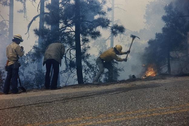
    <summary type="html"><![CDATA[<p><strong><em>In national parks and monuments, flames pose a significant threat to archaeological resources. During the 1977 La Mesa Fire, Bandelier National Monument became the first known park to conduct archaeological surveys on fire lines. </em></strong></p><img src="https://www.intermountainhistories.org/files/fullsize/c2bb9bc0b3c1876b9c14448a59827b75.jpg" alt="Firefighters battling the La Mesa Fire, c. 1977." /><br/><p>Established in 1916 to preserve Ancestral Puebloan archaeological resources near Los Alamos, New Mexico, Bandelier National Monument historically experienced few wildfires. Because the park protected cultural resources instead of natural ones, it extinguished fires to protect archaeological sites. The nearby development of the atomic bomb at Los Alamos, New Mexico, also made the Pajarito Plateau a high-risk area for federal officials, contributing to rapid suppression policies.
In 1977, the U.S National Park Service (NPS) approved NPS-18, a nationwide policy that established new protocols for fire management. Under the new “let-burn” policy, the Park Service allowed natural fires to burn and experimented with deliberate burns in controlled areas. However, the National Historic Preservation Act required archaeological surveys to approve prescribed burn areas. These policies put Bandelier in a delicate position: it had to simultaneously avoid burning cultural resources and promote the let-burn approach. As a result, park managers at Bandelier continued to suppress blazes long after most of the park system allowed them to burn.
            On June 16, 1977, the La Mesa Fire began in the Santa Fe National Forest near Bandelier’s park boundaries. Officials speculated that either a cigarette or a motorcyclist’s engine started it. Because it posed a risk to nearby communities, wildland firefighters worked to suppress La Mesa immediately. Hot, dry conditions and dense vegetation allowed it to spread quickly, threatening both residents and the national monument. By June 17, it entered Bandelier and started to advance towards Los Alamos. NPS evacuated families living in Bandelier’s Frijoles Canyon, demonstrating the immediate threat the flames posed to locals.
Below the surface of the ground, Bandelier contained numerous archaeological sites that researchers never examined. NPS used heavy equipment, including bulldozers, to construct physical barriers where flames could not access fuel. The blaze itself also threatened to destroy delicate structures. These factors meant both La Mesa and the efforts to stop it endangered the national monument. In response, Park Service scientist Millford R. Fletcher worked with cultural resource manager Cal Cummings to enlist volunteer archaeologists on fire lines who surveyed land in front of heavy equipment and recommended locations that would minimize damage to archeological sites. While they could not survey every line in the area, La Mesa damaged only forty percent of the cultural resources it threatened, demonstrating their effectiveness.
On June 21, summer rain slowed La Mesa down, allowing firefighters to contain it. It burned over 23,000 acres, becoming the largest wildfire on the Pajarito Plateau in the twentieth century. The blaze exposed gaps in NPS fire policy, which had not historically accounted for archaeological resources. While federal officials did not address the issue, park managers at Bandelier developed a new management system that ignited small, carefully monitored burns to determine whether officials could safely implement let-burn procedures near cultural resources.</p><p><em><strong><a href="https://www.intermountainhistories.org/items/show/915">For more (including 3 images) view the original article</a></strong></em></p>]]></summary>
    <published>2025-09-23T15:39:30+00:00</published>
    <updated>2026-04-17T19:32:21+00:00</updated>
    <link rel="alternate" type="text/html" href="https://www.intermountainhistories.org/items/show/915"/>
    <id>https://www.intermountainhistories.org/items/show/915</id>
    <author>
      <name>Kaylen Wilson, Northern Arizona University </name>
    </author>
  </entry>
  <entry>
    <title type="html"><![CDATA[Devils Tower National Monument]]></title>
    <summary type="html"><![CDATA[<p><strong><em>Devils Tower is a sacred site for Lakotas and Kiowas. Though designated a U.S. national monument, it still occupies a holy place in modern Indigenous beliefs.</em></strong></p><img src="https://www.intermountainhistories.org/files/fullsize/f3dff2d8b50dc270a78c54e5c3344257.jpg" alt="Devils Tower,  Bear Lodge" /><br/><p>In Wyoming’s Black Hills stands a massive geological monument called Devils Tower. To the Northern Plains tribes—the Lakotas, Arapahos, Cheyennes, Shoshones, Crows, and Kiowas—this monument is known by older names: Bear Lodge, Bear’s Tipi, Bear Peak, and Tree Rock. Like its names, the views and value of the Tower differs between U.S. American and Indigenous peoples.
Devils Tower is a magma pillar which cooled underground until erosion over geologic time exposed it. Scientists have studied the formation since the 1880s and still do not fully agree on the processes. In 1906, President Theodore Roosevelt designated Devils Tower as the first U.S. National Monument. Among its 400,000 visitors annually, rock climbers enjoy the unique challenge of scaling its large column formations.
To indigenous peoples, Bear Lodge has a rich spiritual history and significance. A Lakota elder, Johnson Holy Rock, said when asked about the region, “If a man was starving, he was poor in spirit and in body, and he went into the Black Hills, the next spring he would come out, his life and body would be renewed. So, to our grandfathers, the Black Hills was the center of life, and those areas all around it were considered sacred, and were kept in the light of reverence.”
The Lakotas and Kiowas recount the creation of the Tower by telling of a group of little girls playing in the Plains who ran as bears chased them. The Great Spirit had pity on them and made the earth beneath them rise into a large tower, protecting them from the bears as they tried to claw their way up, to no avail. Their claw marks are seen today as great columns on the sides of the mountain.
A Cheyenne warrior, Wooden Leg, once told a story of a man who fell asleep next to a buffalo head at the base of Bear Lodge. While asleep, he and the buffalo head were miraculously transported up the tower by the Great [Spirit] Medicine. When the man woke up, he feared he had no way down, so he prayed. When he woke up the next morning, the Great Spirit had transported him to the bottom of the tower, leaving the buffalo head at the top, where it has remained since then. Many important spiritual leaders have visited Bear Lodge, fasting, praying, and receiving visions and prophecies during their time there, including the Cheyenne Sweet Medicine, the Lakota Sitting Bull, and Crazy Horse.
Northern Plains tribes hold Bear Lodge in great reverence by performing prayers and ceremonies nearby. Around the monument, signs are posted which read, “Please do not disturb prayer bundles and prayer cloths.” Native peoples leave prayer offerings near the surrounding trails. Traditionally, the Lakota held a Sun Dance at Bear Lodge at the time of the summer solstice. This dance focuses on symbolic sacrifice and renewal of man and nature and is sometimes still performed at Bear Lodge.
According to the Northern Plains Native American tribes, Devils Tower is much more than a national monument, unique geological formation, or great place to rock climb. To them, Bear Lodge represents a place to worship, pray, and receive spiritual experiences.</p><p><em><strong><a href="https://www.intermountainhistories.org/items/show/578">For more (including 3 images) view the original article</a></strong></em></p>]]></summary>
    <published>2022-03-12T09:29:23+00:00</published>
    <updated>2026-04-17T19:32:12+00:00</updated>
    <link rel="alternate" type="text/html" href="https://www.intermountainhistories.org/items/show/578"/>
    <id>https://www.intermountainhistories.org/items/show/578</id>
    <author>
      <name>Leah Waldrop, Brigham Young University</name>
    </author>
  </entry>
  <entry>
    <title type="html"><![CDATA[Dark Sky over Hovenweep National Monument]]></title>
    <summary type="html"><![CDATA[<p><strong><em>Hovenweep National Monument has been inhabited for over ten thousand years. Its long history of celestial observation culminated in Hovenweep’s 2014 designation as an International Dark Sky Park.</em></strong></p><img src="https://www.intermountainhistories.org/files/fullsize/447ea0e1f4175ff2d0eb928d5ecc8b6e.jpg" alt="Milky Way over Hovenweep" /><br/><p>A little over half-a-century after a Latter-day Saint missionary discovered 800-year-old Ancestral Puebloan ruins on the Colorado–Utah border in 1856, Jesse Walter Fewkes of the Smithsonian Institution led a survey of the sites in 1917–1918. Fewkes concluded such a historic site needed to be preserve, and on March 2, 1923, President Warren G. Harding declared Hovenweep a National Monument in the National Park System. Its name means “deserted valley” in the Ute language.
Archaeologists have found evidence of early hunter gatherers in the area dating back to 8000 BCE, but the ruins themselves were used by the Ancestral Pueblo people, who lived in Hovenweep from 900 to 1300 CE. These Ancestral Puebloans practiced celestial observation. Hovenweep National Monument has six clusters of ancient ruins, and within the Holly ruin group there are spiral petroglyphs on a rock wall that are believed to act as markers for equinoxes and solstices.  For the Ancestral Pueblo people, spiral symbols often reresent the sun or sky. On the day of a solstice or equinox, a beam of sunlight hits the spiral and bisects the spiral petroglyph. When sunlight perfectly hit the spiral petroglyph, it would signify passage into the next season for practical purposes like expecting weather for farming but potentially also for ceremonial purposes and rituals in kivas.
Over in Hovenweep Castle of the Square Tower cluster, holes in the walls allow beams of light to enter the interior and serve as a solar calendar. Ancestral Pueblo farmers would have used the changing positions of the sunbeams to track the solar cycle and help guide planting and harvesting. Anthropologists and archaeologists continue hypothesizing potential uses for other buildings in the ruins, such as the large stone masonry towers. Further celestial observation and defensive fortification are the two likely purposes for the towers. Large structures have been used for millennia for celestial observation and ritual, such as the ziggurats of the Middle East and Latin America, and the long history of celestial observation in Hovenweep makes it a possibility.
The International Dark-Sky Association designated Hovenweep National Monument an International Dark Sky Park in July of 2014 at the Gold Tier after it accepted the National Park Service’s application for the designation.  A Gold Tier Dark Sky Park is a rare designation given to places with the highest quality dark skies, the smallest amount of light pollution, and the potential to see 15,000 stars in the sky.  For comparison, typically only 500 stars are visible from a city. An International Dark Sky Park designation is not legally binding, but rather commemorates Hovenweep’s dedication to preserving its clear night sky, an increasingly rare resource.</p><p><em><strong><a href="https://www.intermountainhistories.org/items/show/543">For more (including 3 images) view the original article</a></strong></em></p>]]></summary>
    <published>2021-11-14T05:20:32+00:00</published>
    <updated>2026-04-17T19:32:11+00:00</updated>
    <link rel="alternate" type="text/html" href="https://www.intermountainhistories.org/items/show/543"/>
    <id>https://www.intermountainhistories.org/items/show/543</id>
    <author>
      <name>Emma Svenson, Northern Arizona University</name>
    </author>
  </entry>
  <entry>
    <title type="html"><![CDATA[Quarry Visitor Center at Dinosaur National Monument]]></title>
    <summary type="html"><![CDATA[<p><strong><em>The Dinosaur National Monument Quarry Visitor Center serves as the gateway to the Quarry Exhibit Hall and the world-famous wall of dinosaur bones. </em></strong></p><img src="https://www.intermountainhistories.org/files/fullsize/b6cb4760f180dc788f5036f07588f120.jpg" alt="Cross-section" /><br/><p>In 1909, Earl Douglass, a paleontologist from the Carnegie Museum in Pittsburgh, discovered a site riddled with fossilized dinosaur bones in the northeastern corner of Utah and created a camp where he began excavating remains. In the following six years Douglass sent over 700,000 pounds of fossilized bones, including full skeletons, to museums throughout the country. The discoveries caught the attention of President Woodrow Wilson, who proclaimed the site Dinosaur National Monument in 1915. Douglass began envisioning a museum which would display excavation sites in their original state, and in the 1920s planning for a structure over the quarry began. However, funding insufficiencies delayed building such a museum for the next three decades.
Finally, in the mid 1950s, the Eisenhower administration funded a ten-year program to upgrade the National Parks system in response to the huge visitor boom after World War II. The program was part of the 50th anniversary celebration of the establishment of the Park Service that would occur in 1966, and it come to be known as Mission 66. By May of 1955 the Park Service produced preliminary plans, and a push for funding the project took place. March 1956 saw the announcement of new financing that covered roads, water, housing, and an information point. By May, the Park Service provided the first sketches of the new building. The National Park Service contracted the Anshen and Allen architectural firm from California in 1956 to design the Quarry Visitor Center, and in July Anshen and Allen provided the first seven-page document of preliminary sketches. Included in the sketches was a study of the sun’s movement throughout the year which was imperative to a glass building with sharp angles. However, Park Service Director Conrad Wirth denied the proposal due to budget constraints. After further negotiation, Park Service and Anshen and Allen agreed on plans for the Quarry Visitor Center, and construction began in early 1957. In May 1958, the R. K. McCullough Construction Company of Salt Lake City completed construction at the quarry site, and in June the center opened to the public. 
Today the Quarry Visitor Center remains mostly in its original state. Despite some structural renovation in the 1960s due to shifting soil under the foundation, the aesthetic qualities of the building have been untouched. As visitors enter the courtyard there are restrooms and a covered patio, and an “oasis porch” of shaded space with benches. To the left is the entrance to the lobby where small exhibits share a space with the information desk and shop. To the right is the auditorium which is used to show the orientation movie. The building includes laboratory facilities, a research library, storage, and a dark room. The museum still features many of its original exhibit panels and displays with the addition of a few new ones over the years. The second-floor viewing deck remains open to visitors to explore the quarry site that has been incorporated into the building. Even though excavations are no longer taking place inside the museum, paleontologists left behind their tools, allowing visitors to reminisce on times now past.</p><p><em><strong><a href="https://www.intermountainhistories.org/items/show/515">For more (including 4 images) view the original article</a></strong></em></p>]]></summary>
    <published>2021-10-15T08:26:19+00:00</published>
    <updated>2026-04-17T19:32:11+00:00</updated>
    <link rel="alternate" type="text/html" href="https://www.intermountainhistories.org/items/show/515"/>
    <id>https://www.intermountainhistories.org/items/show/515</id>
    <author>
      <name>Jennifer John, Northern Arizona University</name>
    </author>
  </entry>
  <entry>
    <title type="html"><![CDATA[Fossil Butte]]></title>
    <summary type="html"><![CDATA[<p><strong><em>Congress created Fossil Butte National Monument on October 23, 1972 to protect exceptionally rare paleontological sites and other geographical phenomena in southwestern Wyoming near Kemmerer. Fossil Butte is the site of a 50-million-year-old lakebed from the Eocene Epoch within the Green River Formation.</em></strong></p><img src="https://www.intermountainhistories.org/files/fullsize/7280e502631197b6e088eb0694915fa6.jpg" alt="Fossil Butte National Monument" /><br/><p>Dubbed “America’s Aquarium in Stone” by the National Park Service, Fossil Butte is exceptional because it has many well-preserved fossils, especially those of aquatic animals. It is considered by researchers to be one of the richest paleontology sites on earth. Paleontologists have recovered fossils of crustaceans, gars, stingrays, plankton, crocodiles, turtles, bivalves, and birds, among many others, preserved for 56 to 34 million years. Fossil Butte used to be the smallest of three prehistoric lakes from the Eocene Epoch in what is now southwest Wyoming, northeast Utah, and northwest Colorado, collectively known as the Green River Lake System. The bottom of the lake is thought to have contained hydrogen sulfide, which is poisonous, which prevented fish from scavenging off of the lake bottom. When an animal in the lake died, it sank to the bottom of the lakebed and remained undisturbed, eventually to be covered and preserved beneath the mud. Fossil Butte is also famous for fossils of mass mortalities, where many fish all died at the same time and became fossilized next to each other. This could be caused by a variety of factors like seasonal changes in water salinity or PH. It is likely as well that the hydrogen sulfide became disturbed from time to time and caused poisonings.
Though some explorers like Ferdinand V. Hayden and John C Frémont already knew about the fossil beds in this area, the full extent of Fossil Butte’s paleontological significance wasn’t understood until the late 1860s. The Union Pacific Railroad’s construction passed through the formation, and railroad workers showed fossils to paleontologists. One collector, Robert Craig, began quarrying fossils there in 1897. The site gained interest from museums around the world for its richness in high-quality fossils. As a result of this fame, Congress created the Fossil Butte National Monument in 1972 to preserve some of it for public viewing.
The visitor center of the Fossil Butte National Monument Visitor Center has over eighty fossils on display of various types of prehistoric aquatic creatures, as well as a variety of prehistoric bats, birds, plants, and insects. The center shows a thirteen-minute video to inform visitors about the discoveries paleontologists have made within the site. Visitors are allowed to make their own “fossil imprints” as souvenirs and access an educational computer program about fossils and the natural history of the monument.</p><p><em><strong><a href="https://www.intermountainhistories.org/items/show/514">For more (including 6 images) view the original article</a></strong></em></p>]]></summary>
    <published>2021-10-15T07:17:23+00:00</published>
    <updated>2026-04-17T19:32:11+00:00</updated>
    <link rel="alternate" type="text/html" href="https://www.intermountainhistories.org/items/show/514"/>
    <id>https://www.intermountainhistories.org/items/show/514</id>
    <author>
      <name>Jacob French, Northern Arizona University</name>
    </author>
  </entry>
  <entry>
    <title type="html"><![CDATA[Dinosaur National Monument]]></title>
    <summary type="html"><![CDATA[<p><strong><em>Dinosaur National Monument is a fossil bone quarry where visitors can see fossilized remains still fixed in the rocks. Petroglyphs show earlier human culture, and scenic views and river canyons provide opportunity for sightseeing and recreation.</em></strong></p><img src="https://www.intermountainhistories.org/files/fullsize/cd482b8e85c65dadfd0f3837400f9d44.jpg" alt="The wall of bones" /><br/><p>Earl Douglass was a paleontologist working at Carnegie Museum in Pittsburgh, Pennsylvania. In 1909, Douglass traveled to Utah to look for dinosaur fossils. Years before, he had nearly completed an entire Diplodocus skeleton from Wyoming. The Pennsylvania public loved it, so he was eager to find more fossils for Carnegie Museum. He and his workers excavated thousands of dinosaur fossils at Dinosaur National Monument beginning in 1909 while doing work for the museum. The site near Vernal, Utah, quickly gained worldwide renown for its paleontological research potential. President Woodrow Wilson established the fossil beds as a national monument in 1915. Besides dinosaurs, the site shows culture from past civilizations. Prior to the fourteenth-century, the Fremont people inhabited the region. They left ceramic artifacts, petroglyphs, and pictographs which visitors today can still see.
The Wall of Bones is perhaps the most interesting feature of Dinosaur National Monument. It is a cliff wall with more than 1,500 dinosaur fossils from the late Jurassic period still embedded in the rock. Guests are even permitted to touch the fossils themselves. Another feature is the Quarry Exhibit Hall, the location where Douglass first discovered multiple fossils in 1909. It has fossils, footprints, and exceptionally rare specimens like a fossilized juvenile Stegosaurus.
Dinosaur National Monument provides ample opportunity for sightseeing and recreation. Adventure-seekers can whitewater raft down the Green River and see the towering landmark Steamboat Rock while they appreciate the scenery of the canyons and valleys. They can choose private or commercial rafting trips, which can be as short as a day or as long as a week. Dinosaur National Monument was also made into an International Dark Sky Park by the International Dark-Sky Association. This limits light pollution to allow for better star-gazing. Visitors can camp at one of six different campgrounds, or choose to explore the wilderness to find their own camp site. Dinosaur National Monument contains many miles of hiking trails along rivers, through canyons, and across vast expanses. Picnic areas are available throughout the monument, as well as at the Quarry Visitor Center, Canyon Visitor Center, and the Josie Morris Ranch.</p><p><em><strong><a href="https://www.intermountainhistories.org/items/show/512">For more (including 4 images) view the original article</a></strong></em></p>]]></summary>
    <published>2021-10-15T06:22:17+00:00</published>
    <updated>2026-04-17T19:32:10+00:00</updated>
    <link rel="alternate" type="text/html" href="https://www.intermountainhistories.org/items/show/512"/>
    <id>https://www.intermountainhistories.org/items/show/512</id>
    <author>
      <name>Jacob French, Northern Arizona University</name>
    </author>
  </entry>
  <entry>
    <title type="html"><![CDATA[Chief Barboncito and The Treaty of 1868]]></title>
    <summary type="html"><![CDATA[<p><strong><em>After years of displacement and internment, negotiations between Chief Barboncito and the United States government resulted in a treaty that allowed the Navajo to returned to their homeland in the Four Corners region.</em></strong></p><img src="https://www.intermountainhistories.org/files/fullsize/acdbc3e43efc463260bb43435470b6cc.jpg" alt="Treaty marker" /><br/><p>Navajo Chief Barboncito (1821–1871) played an important role in the negotiations that helped the Navajo return to the Four Corners region in 1868. Fluent in Navajo and Spanish, Barboncito communicated with US negotiators, who used translators that were fluent in English and Spanish, to draft a dual language treaty that would allow the Navajo to return home, making them the first American Indian tribe able to do so.
The Navajo had lived in Bosque Redondo from 1864–1868. Arriving by forced relocation that put an end to the Navajo Wars at the command of General James Carleton and carried out by Colonel Christopher “Kit” Carson, the Navajo internment camp refinement period proved to be a failure due to the high cost required to maintain provisions to keep the Navajo alive. Due to poor soil conditions and resource constraints, the United States needed to rethink their role in confining the Navajo.
In addition to negotiating with the United States regarding Navajo internment, Barboncito was also a spiritual leader and medicine man who gained prominence alongside Chief Manulito and Ganado Mucho due to their diplomacy and oratory skills. When it came time to discuss treaty provisions, Barboncito rejected General William Sherman’s offer to relocate the Navajo to Indian Country in Oklahoma. Fearing that Oklahoma would be similar to Bosque Redondo, Barboncito advocated on behalf of himself and the 9,000 other Navajo that they would be a peaceful people upon their return home, declaring that the area between the four sacred mountains was created and given to them by their gods, First Man and First Woman, solely for them.
The treaty was signed and made official on June 1, 1868. After returning home and following the creation of the Navajo reservation system, Barboncito kept his word, and the Navajo no longer engaged in warring behavior against neighboring white settlements. Compared to the initial reservation boundary, the territory has since tripled in size, currently covering an area the size of West Virginia. The Navajo today can enjoy their ancestral land and continue to teach their traditions and cultures thanks to men like Chief Barboncito.</p><p><em><strong><a href="https://www.intermountainhistories.org/items/show/488">For more (including 3 images) view the original article</a></strong></em></p>]]></summary>
    <published>2021-09-16T22:05:02+00:00</published>
    <updated>2026-04-17T19:32:10+00:00</updated>
    <link rel="alternate" type="text/html" href="https://www.intermountainhistories.org/items/show/488"/>
    <id>https://www.intermountainhistories.org/items/show/488</id>
    <author>
      <name>Colin Tompson, Brigham Young University</name>
    </author>
  </entry>
  <entry>
    <title type="html"><![CDATA[Pompeys Pillar National Monument]]></title>
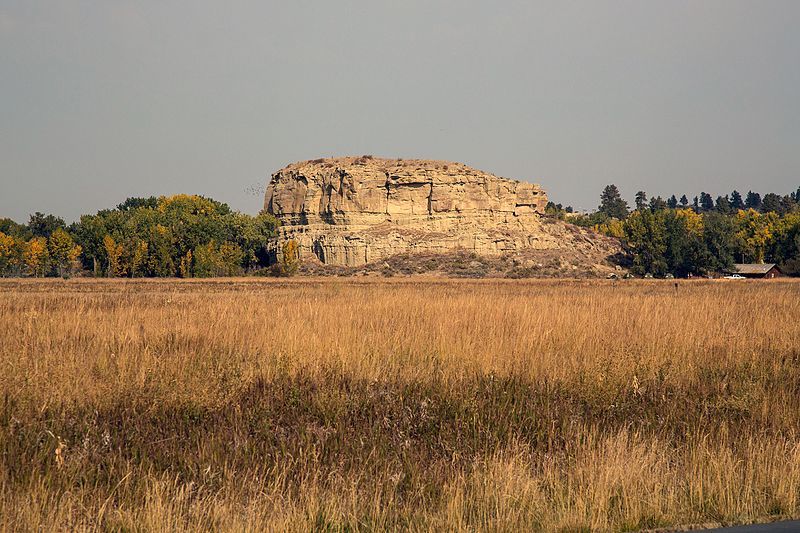
    <summary type="html"><![CDATA[<p><strong><em>Pompeys Pillar is an impressive sandstone formation standing nearly 200 feet above the Yellowstone River. Designated as a national monument in 2001, the pillar features numerous Native American petroglyphs, as well as marks and drawings made by travelers and settlers. The most notable mark on this historic rock, however, is the signature of the great explorer William Clark, who named the pillar after Sacagawea’s son.</p></strong></p><img src="https://www.intermountainhistories.org/files/fullsize/11cc09f1ff08529113f7496d29342260.jpg" alt="Pompeys Pillar" /><br/><p>The summer of 1806 found Lewis and Clark’s Corps of Discovery on their return trip from the Pacific Ocean to St. Louis. Led by Meriwether Lewis and William Clark, the band of explorers, which initially consisted of some 55 people, had traveled from St. Louis, Missouri to the Pacific Ocean. President Jefferson had tasked them to find a viable water route to the Pacific Coast. Moreover, they discovered 178 new plants species and 122 animal species. They charted and mapped the rivers and mountains of the plains and Rockies and established friendly relations with many Native American tribes.</p><p>On June 30, 1806, the Corps were returning home when they decided to make a brief stop at a meadow along the Bitterroot River known as Traveler’s Rest. During that stay, Lewis and Clark determined to divide their forces into different groups so that they could explore as much territory as possible. Clark and Sacagawea, a Shoshone woman, led their party through the Bozeman Pass. They constructed cottonwood log canoes to float down the Yellowstone River. After floating for several days, Clark spotted an enormous rock structure on July 25 and decided to stop and climb it. In his journal Clark recorded, “At 4PM [I] arrived at the remarkable rock situated in an extensive bottom. This rock I ascended and from it's top had a most extensive view in every direction. This rock which I shall call Pompy's Tower is 200 feet high and 400 paces in secumpherance and only axcessible on one side which is from the N.E. the other parts of it being a perpendicular clift of lightish coloured gritty rock.The Indians have made 2 piles of stone on the top of this tower. The nativs have ingraved on the face of this rock the figures of animals &c.” </p><p>Clark named the large sandstone rock Pompys Tower after Sacagawea’s son Jean Baptiste Charbonneau, who Clark nicknamed “Pomp” and who would eventually become Clark’s adopted son. Clark also carved his now famous inscription on the pillar, including his name and the date, July 25, 1806. This mark is one of the few visible remnants of expedition along the Lewis and Clark National Historic Trail.</p><p><em><strong><a href="https://www.intermountainhistories.org/items/show/413">For more (including 3 images) view the original article</a></strong></em></p>]]></summary>
    <published>2020-03-25T00:48:08+00:00</published>
    <updated>2026-04-17T19:32:08+00:00</updated>
    <link rel="alternate" type="text/html" href="https://www.intermountainhistories.org/items/show/413"/>
    <id>https://www.intermountainhistories.org/items/show/413</id>
    <author>
      <name>Rulon Udall, Brigham Young University</name>
    </author>
  </entry>
  <entry>
    <title type="html"><![CDATA[Timpanogos Cave National Monument]]></title>
    <summary type="html"><![CDATA[<p><strong><em>High above the American Fork Canyon floor a natural wonder resides. The Timpanogos Cave system has been enjoyed by thousands of pleasure seekers over the past century. However, the Timpanogos Cave system almost became another hole in the rock. Because of early conservation efforts, the cave system being turned into a national monument, and continued efforts to preserve the cave, so many more people may continue to enjoy much of the beauty that the early discoverers found there. </p></strong></p><img src="https://www.intermountainhistories.org/files/fullsize/ff271d68c4846e9aff15e73e0ebc330f.jpg" alt="Figure 1
" /><br/><p>Timpanogos Cave represents millions of years of gentle, fragile geological formations. For these structures to be maintained in their natural state, human interaction most likely spelled doom for these natural occurring formations. The story of Timpanogos Cave is a story of unsung heroes and efforts that have fulfilled the dream of the National Park Service, to preserve unique areas of nature for enjoyment of all generations in their same state. Once the three caves (Hansen, Middle, and Timpanogos) were discovered, many people made efforts to turn the caves over to the government. The government with their funds from the Forest Service and the National Park Service would be able to continue their efforts in maintaining the natural beauty of the cave while allowing for people to enjoy the beauty of the cave. </p><p>To help maintain the beauty of these caves, President Warren Harding placed the caves and the land surrounding them under federal protection on October 13, 1922.  Almost immediately after the monument was established, trials that threatened the wonders emerged. There were private claims laid on the caves that required cooperation of those who discovered the cave to prove false. Mining claims were made on the land due to its protection under the forest service by a group of people called the Joy Riders. These claims went to court and were ultimately defeated. There was also the difficulty of protecting the cave from the hands of those who toured it. They would take little pieces of the cave like the one in Figure 1, and put them in their pocket to keep. Overtime, punishments were effective enough to discourage most from tampering with the cave ecosystem. </p><p>Once the Timpanogos Cave System was placed under jurisdiction of the National Park Service in the 1933, many problems were minimized even though periodic vandalism and theft still occurred. Under the National Park Service, the next task was to make the caves more accessible to the public due to the increasing popularity of the monument. The Caves became popular due to the spread of mouth and of media created to advertise the mountain and the cave. To make the monument more accessible, a trail was constructed to the caves in 1936 by men who received work from the CCC during the Great Depression. The three caves were also connected in 1939 and lights were installed inside of the cave to allow easier access and pleasure to the guests of the cave (Figure 2). Though difficult, the beauty and integrity of the caves were preserved despite the major projects that took place. </p><p>Despite natural disasters such as floods that destroyed the roads in American Fork Canyon in 1965 and 1983 (Figure 3) and a fire to the main building on the monument in 1991, other updates to the monument that have progressed, and Timpanogos Cave National Monument has grown in popularity.  Now, over 100,000 people visit the monument every year. Despite the continued popularity and visitation of the Caves, the conservation efforts that have been made have allowed the caves to remain relatively the same as discoveries took place in 1887 by Martin Hansen following a mountain lion.</p><p><em><strong><a href="https://www.intermountainhistories.org/items/show/312">For more (including 3 images) view the original article</a></strong></em></p>]]></summary>
    <published>2019-02-22T21:47:03+00:00</published>
    <updated>2026-04-17T19:32:05+00:00</updated>
    <link rel="alternate" type="text/html" href="https://www.intermountainhistories.org/items/show/312"/>
    <id>https://www.intermountainhistories.org/items/show/312</id>
    <author>
      <name>Robert Dayley, Brigham Young University</name>
    </author>
  </entry>
  <entry>
    <title type="html"><![CDATA[Planet of the Apes and Glen Canyon, Arizona<br />
]]></title>
    <summary type="html"><![CDATA[<p><strong><em>The Glen Canyon National Recreation Area is in the states of Arizona and Utah. Large sections of the region feature in Planet of the Apes, including areas such as Lake Powell. </em></strong></p><img src="https://www.intermountainhistories.org/files/fullsize/5050d00397691fecd242bce17699202d.jpg" alt="Roddy McDowall Planet of the Apes makeup 1974" /><br/><p>Glen Canyon is located in northern Arizona’s Vermilion Cliffs National Park. The Glen Canyon National Recreation Area encompasses 1.25 million acres of land spread across both Arizona and Utah. After the construction of the Glen Canyon Dam in 1966, areas of the Glen Canyon region were flooded, creating the Lake Powell Reservoir. The canyon itself was created by the Colorado River as its flow eroded the land over millions of years.</p><p>Glen Canyon, Lake Powell, and the surrounding desert region were all used by Franklin J. Schaffner in the filming of his 1968 film Planet of the Apes. Starring Charlton Heston as the lead astronaut, Taylor, the film tells the story of a trio of astronauts crash landing on what they believe is an alien world, only to find it inhabited by intelligent apes. The film opens when the three astronauts awake from hibernation on their ship and crash land onto an alien planet. The crew abandons ship and begins rafting down the river. After discovering that the surrounding soil is unable to support life, the astronauts encounter both primitive humans and intelligent ape creatures. A series of interactions with ape creatures, included the antagonist Maurice Evans' Dr Zaius, leads to the death of the crew and Taylor’s temporary loss of his voice. Taylor discovers that the planet is in fact earth after being destroyed by his civilization’s nuclear war.</p><p>The mixture of arid and verdant landscapes present in the Glen Canyon region are used in the film to show how much of the land on the future Earth is uninhabitable. The landscape of the region is used not only to convey the feeling of an alien planet, complete with the Ape City sets and enclaves, but also that of a post-apocalyptic landscape—two of the most popular uses for desert environments in science fiction cinema. The newly flooded Lake Powell and the Colorado river also allowed for the rafting scenes early in the film. Lake Powell was used for the initial crash landing scene, while other regions along the river featured rafting. Recognizable canyon formations feature as backdrops throughout the film. Horseshoe Bend is cast as the entrance to the forbidden zone wherein the ruins of human civilization lie. Filming the scenes within the canyon itself proved difficult due to the terrain, and much of the equipment required for the shoots had to arrive by helicopter.</p><p><em><strong><a href="https://www.intermountainhistories.org/items/show/232">For more (including 3 images) view the original article</a></strong></em></p>]]></summary>
    <published>2018-06-19T18:42:25+00:00</published>
    <updated>2026-04-17T19:32:03+00:00</updated>
    <link rel="alternate" type="text/html" href="https://www.intermountainhistories.org/items/show/232"/>
    <id>https://www.intermountainhistories.org/items/show/232</id>
    <author>
      <name>Isaac F. J. Middleton, Northern Arizona University</name>
    </author>
  </entry>
  <entry>
    <title type="html"><![CDATA[Close Encounters of the Third Kind and Devils Tower, Wyoming<br />
]]></title>
    <summary type="html"><![CDATA[<p><strong><em>Devils Tower is a National Monument situated in Wyoming and featured in the climax of the movie Close Encounters of the Third Kind.</em></strong></p><img src="https://www.intermountainhistories.org/files/fullsize/267db7586bb8fa5d3b50f8330221d13e.jpg" alt="Devils Tower CROP" /><br/><p>Devils Tower, located in Crook County, Wyoming, was the first natural formation in the United States to be declared a national monument in 1906. Part of the Black Hills mountain range, the monolith was formed from cooled magma exposed through erosion and stands at 1,267 feet tall.</p><p>The Tower features heavily in Steven Spielberg’s 1977 Close Encounters of the Third Kind. The film tells the story of several individuals’ experiences with extra-terrestrial phenomenon. Focusing on the experiences of Roy Neary, the story follows him from his initial encounter with a UFO to his growing obsession with visions of a mountain and desire to go there. After Neary’s actions grew more intense, his family leaves him. He decides to travel to Devils Tower with fellow UFO witness Jillian Guiler, whose son had been taken by the alien visitors. The Tower had been selected as the contact point, and the area was evacuated by the military under the guise of a chemical leak. Upon reaching the Tower and evading military capture, the two, along with a group from the United Nations and others who had encountered the aliens, witness the arrival of the extra-terrestrial mothership. After the aliens return previous abductees, Neary and others are chosen to go with the aliens to outer space.</p><p>Film production designer Joe Alves scouted the location, and filming began on May 17, 1976. The scenes at the Tower took place in the evening, which meant the crew could only film for a few hours every day to make use of the brief hours of dusk. Devils Tower features heavily throughout the film, even before it is identified as such. Neary’s visions and subsequent obsession with the shape, a silhouette at first then a full structure, are a key part of the film’s narrative. It begins with Neary forming small structures without concentrating, for example, absentmindedly shaping his mashed potatoes into the Tower’s shape. Later, this compulsion to understand the visions leads him to construct more extravagant structures out of clay and dirt. In the latter, Neary destroys large portions of his family’s house, and the neighbor’s garden, and causes his family to leave him out of fear. It is not until Neary sees Devils Tower on the news that he is able to make the connection to the apparent goal of these visions. It is these scenes of Neary’s obsession that solidify the image of Devils Tower as an integral part of the films visual and thematic atmosphere.</p><p><em><strong><a href="https://www.intermountainhistories.org/items/show/226">For more (including 3 images) view the original article</a></strong></em></p>]]></summary>
    <published>2018-06-15T02:08:21+00:00</published>
    <updated>2026-04-17T19:32:03+00:00</updated>
    <link rel="alternate" type="text/html" href="https://www.intermountainhistories.org/items/show/226"/>
    <id>https://www.intermountainhistories.org/items/show/226</id>
    <author>
      <name>Isaac F. J. Middleton, Northern Arizona University</name>
    </author>
  </entry>
  <entry>
    <title type="html"><![CDATA[The Wolfe Homestead]]></title>
    <summary type="html"><![CDATA[<p><strong><em> John Wesley Wolfe, a Civil War veteran, left his family in Ohio to find relief from his wounds in a drier climate. He and his oldest son established a cattle ranch and trading stop for Indians. In their last years on the ranch, John’s daughter Flora and her family kept him company and contributed to the ranch.</em></strong></p><img src="https://www.intermountainhistories.org/files/fullsize/af938743024b683a80bf043ceb5c95ce.jpg" alt="Arches National Park" /><br/><p>John Wesley Wolfe was born on February 17, 1829 in Tennessee. When the Civil War broke out in 1861, John joined the Union even though his home state joined the Confederacy. He fought in several major battles as a member of the 17th Ohio Battery. At the Siege of Vicksburg, John injured his leg lifting a cannon out of the mire and was given a disability discharge. He never walked without the aid of a crutch again, and this injury eventually prompted him to move to Utah.</p><p>In 1898, at the age of sixty-nine, John decided to heed his doctor’s advice and move to a drier climate. He hoped the desert air would alleviate the pain in his leg and stop the infection from spreading. He only managed to convince his son Fred to go with him to southern Utah. John’s wife and their three other children stayed behind in Ohio. John and Fred erected a simple cabin and set to work creating their “Bar DX” ranch. Though it’s not visible today, there was abundant native grass in the area that allowed over 1,000 cattle to graze on the Wolfe’s ranch. </p><p>In 1906, John’s daughter Flora and her family came to live on the ranch. She, her husband Ed Stanley, and their children Esther and Ferol brought new life to the remote homestead. Fred and Ed built a new cabin with wood floors and a window to make Flora and the children more comfortable. The men hauled timber from the Colorado River to use for the walls. They built the roof out of a frame of small logs and a large center beam. Fred and Ed laid bark from juniper trees and dirt from the surrounding hills over the top of the frame. The children helped stuff clay into the cracks between logs for insulation. This cabin is visible from the trail that leads to Delicate Arch in Arches National Park today. </p><p>Despite living in such a remote area, the Wolfes and Stanleys ate well. John irrigated a garden by plugging the creek that ran nearby with a simple dirt dam. He grew squash, corn, pumpkins, and a few extra melons to trade with the Indians who passed through. Few things made John as angry as when a rainstorm flushed out the dam. The family ate rabbit, venison, and chicken until butchering season came each fall and they had fresh beef. John supplanted their diet with groceries like canned milk that he picked up at Thompson Springs. Ed missed fresh milk so much that he once tried to milk a wild cow. The rest of the family watched as the cow kicked both hind feet and Ed quickly learned to be content with canned milk. </p><p>After two years, the Stanleys moved to Moab so their children could receive a formal education. In 1910, John sold the ranch to Tommy Larson and moved back to Ohio. John died in October of 1913 at age eighty-four. In 1914, Marvin Turnbow, the first custodian of Arches National Monument, bought the ranch from Larson. His family used the cabin occasionally until they sold it to Emmit Elizondo, who eventually sold the property to the U.S. government for inclusion in Arches National Monument.</p><p><em><strong><a href="https://www.intermountainhistories.org/items/show/200">For more (including 3 images) view the original article</a></strong></em></p>]]></summary>
    <published>2018-06-07T01:18:25+00:00</published>
    <updated>2026-04-17T19:32:02+00:00</updated>
    <link rel="alternate" type="text/html" href="https://www.intermountainhistories.org/items/show/200"/>
    <id>https://www.intermountainhistories.org/items/show/200</id>
    <author>
      <name>Samuel Hauber, Brigham Young University</name>
    </author>
  </entry>
  <entry>
    <title type="html"><![CDATA[The Larson Homestead in Kolob Canyon]]></title>
    <summary type="html"><![CDATA[<p><strong><em>Gustive O. Larson was a prominent Utah historian. He started a homestead in southern Utah in the 1930s but lost it when the Kolob National Monument was established. During his four summers on the homestead, Gustive learned about Utah history, overcame a severe illness, and built a cabin that stands today.</em></strong></p><img src="https://www.intermountainhistories.org/files/fullsize/fa6d43239eb30b5d24b6a17c13bab6f7.jpg" alt="Larson Cabin " /><br/><p>Gustive O. Larson was born in Holladay, Utah in August 1897. He met Virginia Bean while teaching in Richfield, Utah and married her on February 12, 1926. She supported him as he conducted extensive research into Utah history and participated in the community. Gustive published several books and papers, served as president of the Utah Valley chapter of the Utah State Historical Society twice, served as the chairman of the Iron County chapter of the American Red Cross for nine years, and served as chairman of the Cedar City Library Board. In the early 1930s, Gustive tried homesteading and gained valuable knowledge and experience.</p><p>Gustive set up his homestead in Dry Creek, now known as Kolob Canyon, located in the North West District of Zion National Park. Arthur Fife and William R. Palmer also established homesteads in the canyon. Gustive worked with these two men during the summers to carve out his homestead. Gustive finished his cabin in 1931 and in his personal history said his family was optimistic “to make good our claim to this beautiful little wilderness spot.” In 1932, Gustive’s salary dropped due to the depression and teacher salary cuts in Cedar City where he worked. However, Gustive was pleased with the progress being made on the homestead and the fencing that had been put up the second summer. He described the 1932–1933 school year as difficult because of his failing health and luckless speculation on the stock market. In 1933, Gustive had his appendix and gallbladder removed and his health returned.</p><p>The Larson’s were called to serve a mission for the LDS church in Sweden in 1936. In 1937, while the Larson’s were gone, the US government established the Kolob National Monument. This monument overlapped the three homesteads in the area and would eventually be incorporated into Zion National Park. When Gustive returned from Sweden, he tried to claim his homestead and was denied. The homestead laws required a family to live on the land and improve it for five years. In the summer of 1934, Gustive took several classes at UCLA and brought his family with him instead of living on the homestead. This caused the denial of his claim and the Larson’s were forced to abandon the homestead.</p><p>Though Gustive did not retain the homestead, he gained valuable knowledge from the experience. He started a friendship with his neighbor William R. Palmer, who studied Indian culture and wrote a historical radio series. This friendship influenced Gustive’s own work in the history field. Gustive and his son learned much about the outdoors from Arthur Fife who lived down the canyon. Gustive dealt with damage caused to his property by other neighbors’ goat herds and coordinated with the CCC, who were preparing to develop the region. Zion National Park has preserved the Larson cabin, which is located on the Taylor Creek trail today.</p><p><em><strong><a href="https://www.intermountainhistories.org/items/show/199">For more (including 3 images) view the original article</a></strong></em></p>]]></summary>
    <published>2018-06-07T00:54:45+00:00</published>
    <updated>2026-04-17T19:32:02+00:00</updated>
    <link rel="alternate" type="text/html" href="https://www.intermountainhistories.org/items/show/199"/>
    <id>https://www.intermountainhistories.org/items/show/199</id>
    <author>
      <name>Samuel Hauber, Brigham Young University</name>
    </author>
  </entry>
  <entry>
    <title type="html"><![CDATA[Timpanogos Cave National Monument]]></title>
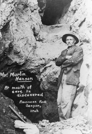
    <summary type="html"><![CDATA[<p><strong><em>Thousands of people climb to the top of Mount Timpanogos mountain every year, but many miss so-called the “heart” of the mountain, the Timpanogos Caves. </em></strong></p><img src="https://www.intermountainhistories.org/files/fullsize/8200d6bc26afa01231bf2211f467097d.jpg" alt="Martin Hansen stands at the natural entrance to Hansen Cave, which he discovered in 1887." /><br/><p>Settlers in Utah Valley discovered three separate caves in American Fork Canyon, seemingly undisturbed. Each cave is filled with exceptional varieties of stalactites, stalagmites, frostwork, flowstone, and other unique cave structures. The first of these caves was discovered in 1877 by logger Martin Hansen as he was cutting wood in the canyon. Mountain lion tracks near where he was working led to the entrance of a cave high up the canyon wall. His discovery came to be known as Hansen Cave. Inside the cave Martin discovered colorful and beautiful formations, which unfortunately were removed by visitors and miners over time. </p><p>The next cave, Timpanogos Cave, was not discovered until 1913. Two young men, James Gough and Frank Johnson, became bored while on a tour of Hansen Cave and went exploring. After becoming stuck and taking an alternate route back to their group, they stumbled upon an opening to another cave. This discovery was eventually lost after being covered by a landslide. Though the entrance was covered, rumors of its discovery were perpetuated by an article in the American Fork Citizen. In 1921, a group went to find it once again. Returning from the summit of Timpanogos, this group of friends decided to visit Hansen Cave in the hope of finding the new cave mentioned in the article. Surprisingly, they rediscovered the entrance to Timpanogos cave and subsequently formed the Payson Alpine Club dedicated to protecting the cave from the thieves and vandals that had destroyed Hansen Cave. </p><p>The last cave was discovered in 1921 by Heber Hansen and his nephew Wayne as they were hunting. While on the opposite side of the canyon, facing the two previously discovered caves, the pair spotted a potential third opening between the two other entrances. This third discovery eventually became known as Middle Cave. The three caves are now connected by tunnels to allow tour groups to pass through.  </p><p>When the people of Utah Valley began to recognize the significance of the caves and the potential for tourism, protecting the caves became a higher priority. Mining claims and previous land disputes threatened the existence of the three caves, and only through the valiant efforts of local citizens, and an appeal to the president of the United States, did it become possible to protect and establish these three caves as the national monument that they are today.</p><p><em><strong><a href="https://www.intermountainhistories.org/items/show/181">For more (including 7 images) view the original article</a></strong></em></p>]]></summary>
    <published>2018-05-25T23:41:53+00:00</published>
    <updated>2026-04-17T19:32:02+00:00</updated>
    <link rel="alternate" type="text/html" href="https://www.intermountainhistories.org/items/show/181"/>
    <id>https://www.intermountainhistories.org/items/show/181</id>
    <author>
      <name>Ellis Benson, Brigham Young University</name>
    </author>
  </entry>
  <entry>
    <title type="html"><![CDATA[The CCC &amp; Capitol Reef National Monument: Creating Roads in the Wilderness]]></title>
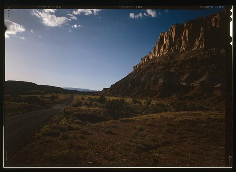
    <summary type="html"><![CDATA[<p><strong><em>At Capitol Reef National Monument, Utah, the Civilian Conservation Corps (CCC) worked tirelessly to build roads making this remote area accessible for visitors to the National Monument.</em></strong></p><img src="https://www.intermountainhistories.org/files/fullsize/8f699dd386756fc441762e509c2267b9.jpg" alt="Torrey-Boulder Road" /><br/><p>In 1937, President Franklin Roosevelt designated 37,711 acres of land in Utah as Capitol Reef National Monument. The new monument was under the jurisdiction of Zion National Park until becoming its own National Park in 1971 under President Richard Nixon. The area was also expanded to 241,000 acres, a very considerable increase in size. However, during the New Deal era of the late 1930s to early 1940s Capitol Reef was simply a small National Monument, remote, with very little infrastructure. Members of the Civilian Conservation Corps camp NM-2 (later renamed NP-6) took on the task of bringing improving infrastructure in the Monument. These men were based west of Fruita, close to Chimney Rock. </p><p>Much of what the CCC men built remains visible within Capitol Reef National Park. Two examples of this are the Fruita ranger station and a powder magazine built into the hillside. The CCC constructed the powder magazine to store the large supply of explosives they needed to quarry sandstone slabs for construction of roads, trails, and buildings within the monument. It is now listed on the National Register of Historic Places and can be seen by the many people who visit Capitol Reef. </p><p>One of the roads built by the CCC to increase access to Capitol Reef National Monument and the surrounding area was the Torrey-Boulder Road, which allowed access to the isolated town of Boulder for the first time. Except for a few scattered lodges and the small Native American population of Havasupai in the Grand Canyon, Boulder had been the last place in the United States to receive its mail by mule—as late as 1940. The road built by the CCC climbs up to 9,000 feet at points, winding its way through thick forests of Aspen and is now a part of Highway 12. The CCC built two similar roads in the area which are colloquially referred to as ‘The Million Dollar Road’ and ‘Hells Backbone Road’, names which imply their construction difficulties.</p><p><em><strong><a href="https://www.intermountainhistories.org/items/show/73">For more (including 3 images) view the original article</a></strong></em></p>]]></summary>
    <published>2017-06-12T22:55:53+00:00</published>
    <updated>2026-04-17T19:31:59+00:00</updated>
    <link rel="alternate" type="text/html" href="https://www.intermountainhistories.org/items/show/73"/>
    <id>https://www.intermountainhistories.org/items/show/73</id>
    <author>
      <name>Sarah Birt, Northern Arizona University and Hull University </name>
    </author>
  </entry>
  <entry>
    <title type="html"><![CDATA[Rainbow Bridge, Native Peoples, and Tourism]]></title>
    <summary type="html"><![CDATA[<p><strong><em>Rainbow Bridge stands as one of the largest natural bridges in the world. It is sacred to six Native American tribes who successfully contested that behavior at the bridge should be respectful because of it’s great cultural importance.</em></strong></p><img src="https://www.intermountainhistories.org/files/fullsize/307a02a0fb0c0964a02078db1b9bb84b.jpg" alt="The Discoverer&#039;s View" /><br/><p>Rainbow Bridge sits at the southern edge of Lake Powell at the tip of Forbidding Canyon, which extends out from Glen Canyon. It stands at 290 feet tall and 275 wide, making it one of the largest natural bridges in the world. In 1909 Byron Cummings and W.B. Douglass publicized the bridge to the world after they saw it with the help of Paiute guides. For centuries Native Americans have known about the bridge and have incorporated it into their spiritual understanding. President William H. Taft designated the bridge a national monument in 1910, and visitors included Teddy Roosevelt who considered the bridge as one of the wonders of the world. </p><p>The waters of Lake Powell rose up to and under the bridge due to flooding from the Glen Canyon Dam, despite the fact that the Colorado River Storage Project Act of 1956 included provisions to protect the monument. Environmentalists took this to heart and there was a new zeal to stop such a thing happening again. The lake changed the accessibility of the bridge as the water allowed tourists to travel by boat to the arc, taking away from the challenging and adventurous journey experienced before.</p><p>For Native American tribes, this new accessibility presented new problems. Rainbow Bridge is an important religious site for the Navajo, Hopi, Ute Mountain Ute, San Juan Southern Paiute, Zuni, and Kaibab Paiute. These tribes felt that Lake Powell was tarnishing their sacred sites and Rainbow Bridge was their biggest concern. Lake Powell attracted tourists who considered the bridge a part of their vacation experience without respecting its religious significance. By the mid-1970s visitors to the bridge were demanding that drinking fountains be installed alongside trash cans for the waste. The bridge had become a part of the party and vacation atmosphere that surrounded Lake Powell. </p><p>In 1974 members of the Navajo tribe filed suit against the Bureau of Reclamation, as well as the Director of the National Park Service and the Secretary of the Interior, in an attempt to preserve their religious site. They lost when the district court of Utah ruled that the Navajo did not have a claim to the land the bridge was on. They also lost their 1980 appeal, as the Tenth Circuit Court of Appeals argued that in this case water storage was more important than religious rights.  </p><p>In April 2017, the National Park Service recognized Rainbow Bridge’s significance to Native Americans by designating it a Traditional Cultural Property. The national monument is the first site in Utah to receive such designation. The hope is that such designation can better preserve Rainbow Bridge for years to come; now any federal project that could impact it has to undergo a vigorous review. For example, geologists have been measuring the vibrations felt by the bridge. Certain actions such as drilling and construction cause vibrations that put strain on the bridge.  Most importantly, the designation is a vital step in recognizing the bridge’s cultural and religious significance to many Native Americans. </p><p><em><strong><a href="https://www.intermountainhistories.org/items/show/63">For more (including 5 images) view the original article</a></strong></em></p>]]></summary>
    <published>2017-06-06T20:09:49+00:00</published>
    <updated>2026-04-17T19:31:59+00:00</updated>
    <link rel="alternate" type="text/html" href="https://www.intermountainhistories.org/items/show/63"/>
    <id>https://www.intermountainhistories.org/items/show/63</id>
    <author>
      <name>George Mumford, Northern Arizona University</name>
    </author>
  </entry>
  <entry>
    <title type="html"><![CDATA[Echo Park Dam and the Early Environmental Movement]]></title>
    <summary type="html"><![CDATA[<p><strong><em>In the 1950s the Environmentalism Movement was only just beginning. For the early movement the battle over Echo Park was significant. </em></strong></p><img src="https://www.intermountainhistories.org/files/fullsize/f436051c94ca67ab4a6e1b81e422a860.jpg" alt="U.S. Geological Survey, 1871" /><br/><p>The Colorado River Storage Project (CRSP) planned for comprehensive development of the Colorado River. By damming the river the Bureau of Reclamation hoped the water could be managed efficiently. At the center of this project would be a dam at Echo Park within Dinosaur National Monument. Echo Park Dam, announced in 1953 by Interior Secretary Douglas McKay, was meant to fulfill multiple purposes. Under the Colorado River Compact of 1922, the Upper Basin states had to provide 7.5 million acre-feet of water to the Lower Basin. Echo Park Dam would be a water storage facility to ensure this obligation could be met. Additionally, the dam would provide water for irrigation and a cheap source of hydroelectricity. This power would, in turn, be used in part to fund other development projects. </p><p>In the 1950s, most Americans understood conservation to mean the efficient use of resources. The Bureau of Reclamation pushed heavily for the development of the Colorado River to fuel the growth of the southwest. CRSP would ensure that the Upper Basin states got all of their allotted water, under the 1922 compact, before it flowed away to California. Even environmentalists at this time saw the build-up of the Colorado Plateau as inevitable: some even welcomed it. However, they were also concerned about preserving areas of particular significance, which is what made the dam a contentious issue. </p><p>Environmentalists believed that it set a dangerous precedent to let Dinosaur National Monument be flooded. In fighting against the dam, environmental leaders, including David Brower of the Sierra Club, argued that a dam at Glen Canyon would satisfy the demand for a dam while saving a national monument. Many were inspired by the columnist Bernard DeVoto who wrote in the Saturday Evening Post that the dam must be stopped to save Dinosaur and its unique natural beauty. DeVoto warned that the Echo Park Dam would set an example that put every national park and monument at risk. This desire to preserve national monuments, not stop dams, motivated many environmentalists. </p><p>In a defining moment, Brower corrected evaporation statistics put forward by the Department of Reclamation in front of a congressional subcommittee. Not only did Brower discredit the department but he also proved that Glen Canyon would make for a suitable replacement, as water loss through evaporation there would not be much greater. Environmentalists employed a successful campaign that became the basis of the movement. New techniques such as the publishing of books known as coffee-table propaganda, added to their arsenal. At the last moment, David Brower tried to convince the Sierra Club to oppose CRSP but failed. The fate of Glen Canyon and Echo Park was sealed. In 1956 Congress passed an amended Colorado River Storage Project Act which now stated that no dam should be built in a national park or monument. The environmental movement had however won a major victory and now had validation of its objectives to preserve the land.</p><p><em><strong><a href="https://www.intermountainhistories.org/items/show/56">For more (including 4 images) view the original article</a></strong></em></p>]]></summary>
    <published>2017-06-03T16:22:52+00:00</published>
    <updated>2026-04-17T19:31:58+00:00</updated>
    <link rel="alternate" type="text/html" href="https://www.intermountainhistories.org/items/show/56"/>
    <id>https://www.intermountainhistories.org/items/show/56</id>
    <author>
      <name>George Mumford, Northern Arizona University</name>
    </author>
  </entry>
  <entry>
    <title type="html"><![CDATA[Creation and Development of Zion National Park]]></title>
    <summary type="html"><![CDATA[<img src="https://www.intermountainhistories.org/files/fullsize/19b24361da3b311b6deffb13f0fe58af.jpg" alt="Stephen Mather" /><br/><p>Zion National Park has its origins in the Progressive Era, when when President Taft declared the area where Zion is now (near Springdale, UT) as Mukuntuweap National Monument to preserve Zion’s main canyon. The National Parks Service, which was created by Congress in 1916, changed the name to Zion in 1918 as the original Pauite name, meaning “straight canyon,” was unpopular. Zion, the Hebrew word for sanctuary and one that resontated with surrounding Mormon (LDS) communities, was thought a much better name to capture its beauty. Only one year later Congress changed this monument into Utah’s first national park: Zion National Park.</p><p>The first director of the National Parks Service, Stephen Mather, recognized that Zion’s isolated location made it hard for people to visit, so he promoted road construction through the park. One road had already been built in 1917, which went from the present day visitor’s center to the Grotto area. This, along with the very first visitor’s center, Camp Wylie, offered visitors places to plan their day in the park. One of the first projects after Zion was made a national park was the Mt. Carmel Highway and tunnels. Construction began in 1927 and was completed and open for the public a little under three years later in 1930. The 1.1 mile long Mr. Carmel tunnel stood firm until one of the sandstone pillars collapsed in 1958 and had to be closed a few weeks for construction. The tunnel is now electronically monitored around the clock in order to give warning of any recurrence or weaknesses.</p><p>In 2012, Zion National Park was the 6th most visited national park with 2,973,607 visitors. These numbers kept growing, and in 2016 the park had 4,317,028 visitors. These visitors enjoy driving, hiking, and rappelling through Zion’s magnificent canyons. </p><p><em><strong><a href="https://www.intermountainhistories.org/items/show/49">For more (including 4 images) view the original article</a></strong></em></p>]]></summary>
    <published>2017-05-27T15:47:16+00:00</published>
    <updated>2026-04-17T19:31:58+00:00</updated>
    <link rel="alternate" type="text/html" href="https://www.intermountainhistories.org/items/show/49"/>
    <id>https://www.intermountainhistories.org/items/show/49</id>
    <author>
      <name>Rachel Nyfeler, Brigham Young University</name>
    </author>
  </entry>
  <entry>
    <title type="html"><![CDATA[From Fossils to Conservation: Dinosaur National Monument]]></title>
    <summary type="html"><![CDATA[<p><strong><em>One of the most unique National Parks or Monuments in Utah, Dinosaur National Monument, is home to an enormous fossil quarry. It was also the center of an environmental controversy over reclamation and dam construction in the 1950s.</em></strong></p><img src="https://www.intermountainhistories.org/files/fullsize/318fadb436f495a4195e8c42e66aa223.jpg" alt="Dinosaur National Monument East Entrance" /><br/><p>Dinosaur National Monument consists of over 210 acres of mostly uninhabited land owned by the federal government, 91% of which is managed as Recommended Wilderness. Dinosaur National Monument is unlike the other National Parks Service land in Utah. It is home to almost 26 full dinosaur skeletons from over 10 different species. These fossils were discovered in 1909 by Professor Earl Douglass from Carnegie Museum, who was responsible for excavating the fossils in the quarry. Given that these fossils are 150 million years old, the area was declared a National Monument in 1915 in order to protect the fossils and keep the quarry intact. In 1938, the land of the national monument was expanded to protect the canyons of the Green and Yampa rivers. The National Monument land is not only home to these dinosaurs, but it was home to prehistoric people and archaeological sites as well.</p><p>Fremont Indians inhabited the area for hundreds of years (approximately 200-1300 AD). They have left their mark on the territory, similar to the dinosaurs. There is an abundance of petroglyphs and pictographs within the monument boundaries. Many of these ancient drawings are of animals and other things the Fremont Indians would have interacted with. It is unclear as to why exactly these people left their mark in this way, but they have stood the test of time to show us of their existence in eastern Utah. Other tribes have also inhabited the area since this time, including the Ute and Shoshone tribes. Prior to 20th excavation, the area was also traversed by the  Domínguez-Escalante Expedition in 1776. </p><p>In the early 1950s the Bureau of Reclamation proposed the building of a dam on Echo Park, which is located on the Green River in the National Monument. Many conservationists fought against this proposal because land owned by the National Park Service was not allocated for development. Fortunately for the National Monument, the Council of Conservationists were able to shut down the proposal after six years and dozens of publications. Dams were then built in Glen Canyon and Flaming Gorge to avoid being on any National Park Service land, particularly Dinosaur National Monument. Today the National Monument stands as a reminder of extinct prehistoric creatures, ancient civilizations, and environmental conservation.</p><p><em><strong><a href="https://www.intermountainhistories.org/items/show/40">For more (including 3 images) view the original article</a></strong></em></p>]]></summary>
    <published>2017-05-02T21:43:47+00:00</published>
    <updated>2026-04-17T19:31:58+00:00</updated>
    <link rel="alternate" type="text/html" href="https://www.intermountainhistories.org/items/show/40"/>
    <id>https://www.intermountainhistories.org/items/show/40</id>
    <author>
      <name>Nicole Anderson, Brigham Young University</name>
    </author>
  </entry>
</feed>