<?xml version="1.0" encoding="UTF-8"?>
<feed xmlns="http://www.w3.org/2005/Atom">
  <title type="text">Intermountain Histories</title>
  <updated>2026-04-17T19:32:17+00:00</updated>
  <generator uri="http://framework.zend.com" version="1.12.20">Zend_Feed_Writer</generator>
  <link rel="alternate" type="text/html" href="https://www.intermountainhistories.org/"/>
  <link rel="self" type="application/atom+xml" href="https://www.intermountainhistories.org/items/browse?output=rss2"/>
  <id>https://www.intermountainhistories.org/</id>
  <author>
    <name>Intermountain Histories</name>
    <uri>https://www.intermountainhistories.org</uri>
  </author>
  <link rel="hub" href="https://pubsubhubbub.appspot.com/"/>
  <entry>
    <title type="html"><![CDATA[American Fork Second Ward Meeting House]]></title>
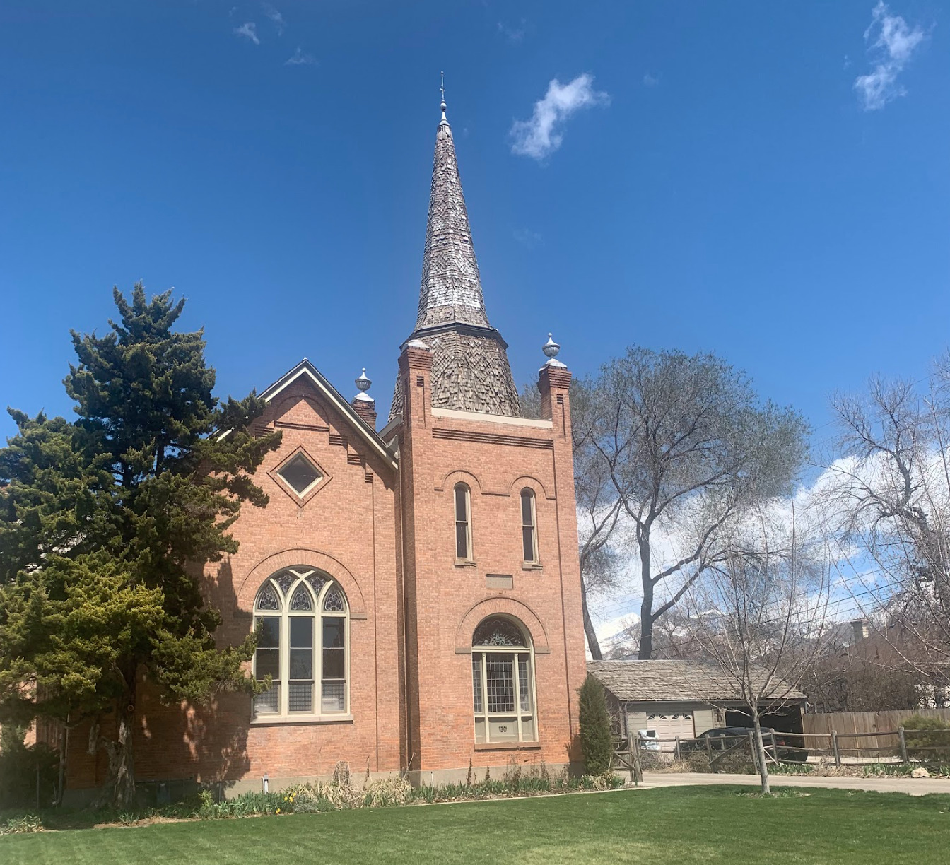
    <summary type="html"><![CDATA[<p><strong><em>The American Fork Second Ward Meeting House was built in response to the expansion of the American Fork settlement. Latter-Day Saints attended meetings there for almost eight decades. Although its use has changed, today it remains an excellent example of early 20th century gothic architecture.</em></strong></p><img src="https://www.intermountainhistories.org/files/fullsize/6368158aa6c18f215b83f77b7eb32afd.jpg" alt="East side steeple, American Fork Meeting House " /><br/><p><span style="font-weight:400;">The American Fork Second Ward Meeting House, located in American Fork Utah, was constructed in 1903 by members of The Church of Jesus Christ of Latter-day Saints. The building was originally proposed by Bishop Joseph H. Storrs on September 29, 1901. After a unanimous vote in favor of building the meeting house, plans for its construction began immediately. The ward members donated their time, talents, and money to the construction of the building. Though still under construction, they began using the meeting house in 1903. Eventually the steeple was finished, all debts were paid, and the meeting house was dedicated on February 17th, 1909. The total cost of the building was $10,000.20. In 1929 the ward members voted to expand the building to house all auxiliaries. The expansion and remodel included updating the chapel in the southeast section of the building beneath the steeple and the addition of a new recreational hall. The construction resulted in the church's current U-shape. John L. Firmage and his wife, members of the ward, donated $15,000 to the remodel. As a result, the addition was often referred to as the Firmage recreational hall. Architect Don Carlos Young, of Young and Hansen Architects, designed the renovation in the original gothic style. The total cost of the project was $48,555.54 by the end of the project. </span>
<span style="font-weight:400;">After the remodel, the updated chapel was used only for sacred purposes while the recreation hall was used for all other activities. The recreation hall was frequently the location of wedding receptions, dramas, and other community gatherings. The renovation also created enough space for classrooms to accommodate Sunday School and other auxiliary meetings. It even included offices for Bishopric members. </span>
<span style="font-weight:400;">The American Fork Second Ward utilized the building until the early 1980s when it was abandoned for a newer meeting house. In 1984 the abandoned church building was purchased by Michael Bigelow, who owned the building in 2023. An application was submitted for the meeting house to become a historical site in November 1991 and the historical status was granted in 1992. Bigelow has since made small updates to accommodate a residence for his family on the upper floor Sunday School room, and minor changes to utilize the space for their pipe organ design and construction business that is on the main and basement levels. The Bigelow family has been careful to maintain the original gothic architecture of the meeting house. </span></p><p><em><strong><a href="https://www.intermountainhistories.org/items/show/766">For more (including 4 images) view the original article</a></strong></em></p>]]></summary>
    <published>2024-01-18T03:23:29+00:00</published>
    <updated>2026-04-17T19:32:17+00:00</updated>
    <link rel="alternate" type="text/html" href="https://www.intermountainhistories.org/items/show/766"/>
    <id>https://www.intermountainhistories.org/items/show/766</id>
    <author>
      <name>Cecilie Cooper, Brigham Young University</name>
    </author>
  </entry>
  <entry>
    <title type="html"><![CDATA[Snowflake: Zion on the Little Colorado]]></title>
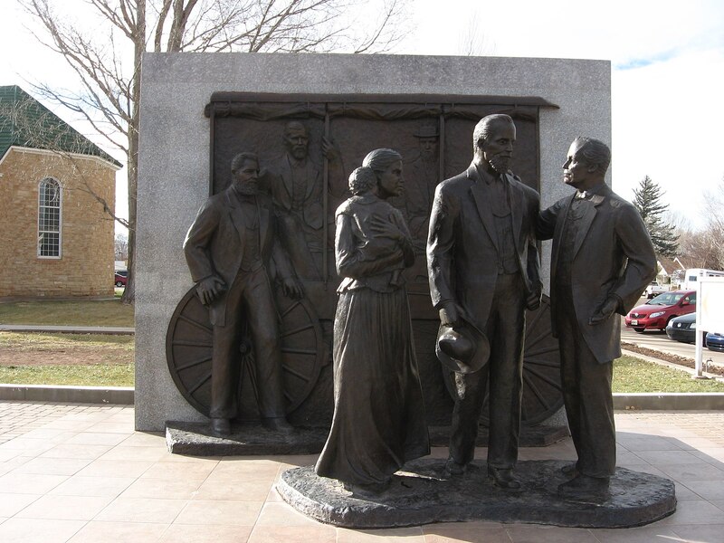
    <summary type="html"><![CDATA[<p><strong><em>Snowflake, Arizona is a small town located in the eastern portion of the state along a tributary of the Little Colorado River known as Silver Creek. It was founded in 1878 by William Jordan Flake and a group of Mormon pioneers who had been directed by Brigham Young to colonize Arizona. The town was officially incorporated in 1919.</em></strong></p><img src="https://www.intermountainhistories.org/files/fullsize/37e4b095306e0664935a3b27b26d576d.jpg" alt="The Snowflake Monument" /><br/><p><span style="font-weight:400;">After finally arriving in the Salt Lake Valley in the late 1840s, early converts of the Church of Jesus Christ of Latter-day Saints deserved a rest. After gathering from across the nation and overseas and fleeing persecution in their flight across the Great Plains, the Saints finally arrived in Salt Lake. They began to make the desert “blossom as a rose” and settled themselves into the comfort of their new home. However, Church President Brigham Young’s ambitions for this fledgling “Zion” extended far beyond the confines of the Salt Lake Valley. His envisioned state of “Deseret” was much larger, and he soon began sending Church members to make new settlements across the Intermountain West.</span>
<span style="font-weight:400;">Church leaders called one such group to settle the Little Colorado River in present-day Arizona in 1876. Among them was William Jordan Flake, a rancher from Beaver who had been orphaned as a child due to the dangers of pioneering. Initially horrified with the idea of leaving all he had worked for to make for the Arizona desert, William asked President Young if he might just go for a year or two and then return to Beaver. Young’s reply was unequivocal: “Sell all that you have, that you cannot take with you. Take your family and go there to settle the Saints. Leave nothing to come back to.” William and his pioneer companions obeyed the command and, upon arriving in the Little Colorado Valley, they established the settlements of Ballinger’s Camp, Sunset, Old Taylor, and Allen’s Camp. The early settlements initially struggled against the hostile environment and the difficulty of living the standards set by the “United Order,” a Church movement which called for collectivist, communal living. William Flake, troubled by these </span><span style="font-weight:400;">problems, decided to look for a place to build a new settlement. He rode out to meet James Stinson, a rancher who had acquired and irrigated 300 acres on Silver Creek, a tributary of the Little Colorado. Stinson said he would sell his land for $12,000, which William raised by convincing Church leaders to procure the sale of cattle from their Utah ranches.</span>
<span style="font-weight:400;">On July 21, 1878, Flake and other pioneer families moved onto the ranch. Soon more followed. On September 24th of the same year, Church Apostle Erastus Snow visited the townsite, and they decided to name the settlement Snowflake, a combination of the two men’s names. The town grew steadily. In 1892, tragedy struck when William’s son Charles was killed in a shootout while attempting to arrest a suspected bank robber (the outlaw was also killed in the gunfight). Nevertheless, Snowflake became one of the more successful of the Little Colorado Valley settlements, and the town was eventually incorporated in 1919. Snowflake now stands as a monument to the legacy of faith left by the early Mormon pioneers.</span></p><p><em><strong><a href="https://www.intermountainhistories.org/items/show/742">For more (including 4 images) view the original article</a></strong></em></p>]]></summary>
    <published>2023-04-10T19:01:01+00:00</published>
    <updated>2026-04-17T19:32:16+00:00</updated>
    <link rel="alternate" type="text/html" href="https://www.intermountainhistories.org/items/show/742"/>
    <id>https://www.intermountainhistories.org/items/show/742</id>
    <author>
      <name>Joseph Flake, Brigham Young University</name>
    </author>
  </entry>
  <entry>
    <title type="html"><![CDATA[Historic Pine Valley&#039;s Latter-day Saint Chapel]]></title>
    <summary type="html"><![CDATA[<p><strong><em>In 1856, early settlers of Southern Utah built a chapel in Pine Valley. It is the longest-operating chapel in The Church of Jesus Christ of Latter-day Saints.</em></strong></p><img src="https://www.intermountainhistories.org/files/fullsize/b7335f22f5911fdde2b2529a24866156.jpg" alt="Pine Valley Chapel today" /><br/><p>While herding cattle during the summer of 1855, members of The Church of Jesus Christ of Latter-day Saints who had been called to settle southern Utah discovered the location of beautiful Pine Valley in southwestern Utah. The following year, St. George residents went to Pine Valley to harvest timber and establish several sawmills.
As more people settled in Pine Valley, they constructed a chapel. They called upon Ebenezer Bryce, a shipbuilder from Scotland and the namesake for Bryce Canyon National Park in Utah, to design and build the structure. There is some discrepancy regarding the methods used to design the chapel. Some sources claim that because he was a shipbuilder, the roof of the building is constructed to model an upside-down ship, while other sources state that Bryce used materials appropriately common for buildings, not ships.
While the roof may look similar to a ship, the description provided by The Church of Jesus Christ of Latter-day Saints gives doubt to that claim: the building is made of pine wood, from “the finest trees in the valley, the same stand as those from which the pipe organ in the Salt Lake Tabernacle was constructed.” The foundation is made of local stone, mainly granite and red limestone. The building has three floors: a basement in which auxiliary meetings were held, a ground floor used for community purposes and as a schoolhouse, and an upper floor which contains the building’s chapel, used as the main space of worship.
Following the chapel’s original completion, Latter-day Saints in Pine Valley have since added an attic containing pictures of the original settlers and other historical artifacts. Another small building, the Tithing Office, was constructed in the corner of the lot. In 1971, the two buildings, the chapel and Tithing Office, were added to the National Register of Historic Places. Both are still in use today by Pine Valley locals as a church building and community gathering place, making it the longest-operating chapel in The Church of Jesus Christ of Latter-day Saints.</p><p><em><strong><a href="https://www.intermountainhistories.org/items/show/485">For more (including 3 images) view the original article</a></strong></em></p>]]></summary>
    <published>2021-09-15T07:33:02+00:00</published>
    <updated>2026-04-17T19:32:10+00:00</updated>
    <link rel="alternate" type="text/html" href="https://www.intermountainhistories.org/items/show/485"/>
    <id>https://www.intermountainhistories.org/items/show/485</id>
    <author>
      <name>Emily Little, Brigham Young University</name>
    </author>
  </entry>
  <entry>
    <title type="html"><![CDATA[Cove Fort<br />
: A Bulwark of Safety]]></title>
    <summary type="html"><![CDATA[<p><strong><em>Cove Fort is one of the few remaining forts built by the Latter-day Saint pioneers. Under the direction of Brigham Young, the fort was constructed in 1867 by Ira Hinckley and 40 other men near Cove Creek in today’s Millard County. Originally intended to protect travelers from attack, the fort served as a major waystation for more than a decade. After changing ownership several times, the Hinckley family purchased the fort in 1989 and later donated it to The Church of Jesus Christ of Latter-day Saints.</em></strong></p><img src="https://www.intermountainhistories.org/files/fullsize/0ef807b9607b7b3937c89b7c5f788dd3.jpg" alt="Cove Fort" /><br/><p>In the spring of 1865, Mormon settlers met with Utes of Sanpete Valley, hoping to find a resolution to years of sporadic disagreements and occasional violence between the groups. Instead of alleviating tensions, however, even greater violence erupted with the onset of the Black Hawk War. Brigham Young previously encouraged the Saints to treat Indians well, saying, “We are settled upon their lands, which materially interrupts their success in hunting, fishing, etc… For these reasons, it behooves us to exercise toward them all possible kindness, liberty, patience, and forbearance.” While his policy of kindness toward Native Nations continued, Young simultaneously recognized Mormon settlers were vulnerable to attack after dispossessing tribes of some of their settlement sites and using up the region’s finite resources.</p><p>The area around Cove Creek was a particularly dangerous resting place for travelers as 30 miles of uninhabited desert lay in both directions. On April 12, 1867, Circleville resident Ira Hinckley received a letter from Brigham Young extending a calling for him to construct a fort near Cove Creek. Its purpose was to “afford protection from the Indians to the Telegraph & Mail Stations and to travelers who are almost constantly on the road. Also to furnish feed and protection from and weather to this latter class.” Hinckley immediately told the messenger to tell Brigham Young he would accept the calling.</p><p>A few days later, Hinckley traveled to Cove Creek with his brother Arza and forty other men, and within seven months they finished building Cove Fort. While <span>most pioneer-era forts were wooden, Cove Fort was instead constructed out of volcanic rock, contributing to its structural longevity.</span></p><p></p><p>Although relatively small, measuring 100 feet by 100 feet, Hinckley and his men built an impressive fortress. The walls were 18 feet high, 4 feet thick at the base, and 2 feet at the top. Gun ports lined the walls. The fort had rooms for the Hinckley family, visitors, a kitchen and dining area, and a room for a telegraph station, which was installed in February 1867. There was also a ranch on site to provide food and a blacksmith shop to service the horses and wagons of travelers.</p><p>While the fort was initially designed for protection, it was never attacked, and the inhabitants maintained good relations with the local tribes. It did, however, serve as a refuge for all those that visited. Families, telegraph operators, mail carriers, trail workers, and even occasional Utes called upon the Fort for a place to sit or stay the night. Hinckley’s son Ira Parnell Hinckley said, “Within its then impregnable walls were safely sheltered thousands, both good and bad, the venturesome and the timid, the desperado and the saint, as they moved westward in quest of gold, or eastward in disappointment, or back and forth in their routine duty. Without it, what might have been, no one knows.”</p><p>The fort was used as a waystation from 1867 to 1882, but as the railroad became increasingly popular, fewer travelers visited the fort. The Hinckley family occupied Cove Fort until 1890, and then in 1919 the Church signed it over to William Henry Kesler. In 1989, descendants of Ira and Arza Hinckley purchased the land back from the Kesler family and subsequently donated it to The Church of Jesus Christ of Latter-day Saints. The Church restored Cove Fort to its original condition and Gordon B. Hinckley, then a member of the Church’s First Presidency and a descendant of Ira Hinckley, dedicated it as a historic monument on May 21, 1994.</p><p><em><strong><a href="https://www.intermountainhistories.org/items/show/468">For more (including 4 images) view the original article</a></strong></em></p>]]></summary>
    <published>2021-09-10T06:57:52+00:00</published>
    <updated>2026-04-17T19:32:09+00:00</updated>
    <link rel="alternate" type="text/html" href="https://www.intermountainhistories.org/items/show/468"/>
    <id>https://www.intermountainhistories.org/items/show/468</id>
    <author>
      <name>Bethany Erickson, Brigham Young University&amp;#32;&amp;amp;&amp;#32;Lindsey Conger, Brigham Young University</name>
    </author>
  </entry>
  <entry>
    <title type="html"><![CDATA[The American Fork Wall]]></title>
    <summary type="html"><![CDATA[<p><strong><em>The American Fork Wall was a wood and earthen structure meant to encompass the entirety of the American Fork settlement (then known as Lake City) for protection.</em></strong></p><img src="https://www.intermountainhistories.org/files/fullsize/b424cbe5ceb277a4cb095b6b519886f9.jpg" alt="Plaque indicating the Fort Wall" /><br/><p>When the Mormon pioneers migrated to the Great Basin to construct new settlements in July 1847, they initially settled in the Salt Lake Valley. As the population grew, the need for new settlements beyond the valley arose. This led to the establishment of Lake City, now known as American Fork. Settlers faced a reality of few supplies, harsh weather, and uncertainty amid an exposed position in Ute territory. 
General Daniel H. Wells and the Deseret Militia took the offensive about the Timpanogos Utes on March 5, 1849, killing several dozen Utes in the Battle Creek Massacre near present-day Pleasant Grove. Afterward, Wells ordered the American Fork villagers to construct a twelve-foot-tall wall surrounding the town for protection. He and other leaders feared reprisal for their hasty and violent actions against their native neighbors. Leaders like Wells were far more concerned with the need for a wall than were American Fork settlers, evidenced by the reality that they never truly finished building the wall according to its planned specifications.
To divide the labor, each family was required to build the portion of the wall connected to their plot of land. This resulted in the construction taking a longer than planned, and each section differed in dimension and construction. The city code references a tax levied on any citizen that did not nor could not complete their portion of the wall, but no record has been found documenting this bylaw’s implementation.
Eventually, in 1855, a significant enough portion of the wall was completed that it could be described as encompassing the town; however, it never reached the height of twelve feet as originally ordered. At that time 85 Latter-day Saint families lived within the fort walls. The Utes exercised tremendous restraint towards their new neighbors and never attacked the settlement before, during, nor after the wall’s construction. Whether the wall served as a reasonable deterrent to such threats or was an unnecessary product of exaggerated concerns cannot be confirmed. Today all physical remnants of the wall have been lost to time with the exception of a number of stones found in William S. Robinson park in downtown American Fork. A small plaque affixed to the base of a statue in the same park offers information about the wall.</p><p><em><strong><a href="https://www.intermountainhistories.org/items/show/467">For more (including 4 images) view the original article</a></strong></em></p>]]></summary>
    <published>2021-09-10T06:37:18+00:00</published>
    <updated>2026-04-17T19:32:09+00:00</updated>
    <link rel="alternate" type="text/html" href="https://www.intermountainhistories.org/items/show/467"/>
    <id>https://www.intermountainhistories.org/items/show/467</id>
    <author>
      <name>Collin Carroll, Brigham Young University</name>
    </author>
  </entry>
  <entry>
    <title type="html"><![CDATA[Fort Utah (Provo)]]></title>
    <summary type="html"><![CDATA[<p><strong><em>Within a year of the establishment of Fort Utah, relations between Latter-day Saint settlers and the Timpanogos Utes dissolved into violence, culminating in a two-day conflict. The original Fort Utah has since been demolished, but a replica stands in its place in Provo, Utah.</em></strong></p><img src="https://www.intermountainhistories.org/files/fullsize/0d695e51f1f5d39ac9125b391c285fc3.jpg" alt="Drawing of Fort Utah in the winter" /><br/><p>Fort Utah was first established a mile and a half east of Utah Lake by a company of one hundred and fifty Latter-day Saints. Led by John Higbee, the Saints arrived on April 1, 1849. They chose the location with the intention to farm on the fertile river soil, but when President Brigham Young visited the fort, he suggested they move to higher ground. The secondary location became the nucleus for the city of Provo. The Saints settled next to the indigenous village of the Timpanogos Utes. Initially, the Utes treated their new neighbors with kindness and generosity, and they fished and gambled together.
That winter, however, misunderstandings broke out between the Utes and Saints. It began in August with a dispute between Richard Ivie and a native known to the Latter-day Saints as Old Bishop, whom Ivie accused of stealing his shirt. When Bishop refused to give the shirt up, Ivie and his friends killed him and threw his body into the Provo River. Furious, the Timpanogos demanded the settlers hand over the murderers. When their requests were denied, they insisted the Saints provide compensation for Bishop’s death, which the Saints also refused. Considering how generous the tribe had been in sharing their prized fishing and hunting resources during the summer, the Utes felt justified in collecting rent through involuntary cattle and corn payments from their neighbors during the fall and winter. As the amicable relations began to sour, Higbee asked Brigham Young permission to declare war against the Timpanogos, whom he misrepresented to Young as hostile.
Young granted the request. Parley P. Pratt and Willard Richards agreed with him, not wanting to find themselves cut off from their southern colonies. They sent the Nauvoo Legion to assist the local Latter-day Saints in attacking the Timpanogos. After just one day, the soldiers cornered their enemies into an abandoned cabin. The next day they placed shields on sledges and attacked. Desperate, the natives fled during the second night only to be hunted down. When the fighting ended, there were more than one hundred Timpanogos casualties and one dead Latter-day Saint. This dark episode serves as a reminder that while Latter-day Saints generally had positive interactions with the Native Americans, there were certainly episodes of unwarranted and reprehensible violence.</p><p><em><strong><a href="https://www.intermountainhistories.org/items/show/465">For more (including 3 images) view the original article</a></strong></em></p>]]></summary>
    <published>2021-09-09T22:51:24+00:00</published>
    <updated>2026-04-17T19:32:09+00:00</updated>
    <link rel="alternate" type="text/html" href="https://www.intermountainhistories.org/items/show/465"/>
    <id>https://www.intermountainhistories.org/items/show/465</id>
    <author>
      <name>Andrew Burt, Brigham Young University</name>
    </author>
  </entry>
  <entry>
    <title type="html"><![CDATA[Charles Walker: St. George Poet]]></title>
    <summary type="html"><![CDATA[<p><strong><em>Charles Walker was called to the Cotton Mission in St. George and made his living there as a blacksmith and stonemason. He helped construct the St. George Temple and was renowned for his poems and songs</em></strong></p><img src="https://www.intermountainhistories.org/files/fullsize/153a43781a51f0e34aef0043afac9d06.jpg" alt="Charles L. Walker" /><br/><p>The scorching temperatures, sparse vegetation, and endless red rock of Saint George, Utah were all that greeted early settlers in the Cotton Mission. Charles Walker, born 1832 in Leek, England, was one of the individuals called by Brigham Young to settle the area and produce cotton to supplement the income for The Church of Jesus Christ of Latter-Day Saints. Upon arriving in 1862, Walker remarked, “St. George is a barren looking place. The soil is red and sandy. On the North ranges a long high red rocky bluff. On the East is a long black ridge of volcanic production. On the west the same. On the south runs the Virgin river, a shallow, rapid stream from which a great portion of the land is irrigated. To look on the country it [is a] dry, parched, barren waste with here and there a green spot on the margins of the streams.” While his observation seemed bleak, Walker exuded optimism with the work that he believed God had called him to do. He wrote in his personal journal, “Well it’s all right; we shall know how to appreciate a good country when we get to it, when the Lord has prepared the way for his people to return and build up… Zion.” Walker’s time in St. George reflected the stalwart nature of those called to settle far Western settlements, and his life in the area would have a significant impact on those around him.
The initial hope that settlers could grow cotton as a cash crop was dashed by poor soil quality. In an attempt to keep the community thriving, Brigham Young ordered the construction of a large public works project to bolster the economy: a new temple. Walker transitioned to stonemasonry and worked on the temple constantly. When the temple was completed, Walker participated in the, and a song he wrote for the occasion was sung at the event. When Walker was not busy with blacksmithing or working on the temple, he spent time with his family and saw to his various church callings. One labor that endeared him to the hearts of his neighbors was his gifted ear for writing hymns, the most famous of which is “Dearest Children, God is Near You.”
Walker later adopted polygamy as practiced by Latter-day Saints in the nineteenth century, marrying his second wife, Sarah Smith. His first wife, Abigail Middlemass, helped him select Sarah, and the trio lived together for the rest of Walker’s life. Each wife gave birth to eight children, sixteen total, with twelve of them reaching adulthood. Walker noted that his peculiar family situation allowed him to labor on the temple and work in his shop more because the burden of running the household was shared between his spouses. Walker also kept himself busy as an assistant marshal for the city and a leader in the local militia. He passed away in 1904, leaving behind a legacy of faithfulness and work ethic on the Utah Frontier.</p><p><em><strong><a href="https://www.intermountainhistories.org/items/show/464">For more (including 3 images) view the original article</a></strong></em></p>]]></summary>
    <published>2021-09-09T22:12:39+00:00</published>
    <updated>2026-04-17T19:32:09+00:00</updated>
    <link rel="alternate" type="text/html" href="https://www.intermountainhistories.org/items/show/464"/>
    <id>https://www.intermountainhistories.org/items/show/464</id>
    <author>
      <name>Dalton Bennett, Brigham Young University</name>
    </author>
  </entry>
  <entry>
    <title type="html"><![CDATA[The Grave of Levi Ward Hancock<br />
]]></title>
    <summary type="html"><![CDATA[<p><strong><em>Levi Ward Hancock was an early leader of the Church of Jesus Christ of Latter-day Saints. </em></strong></p><img src="https://www.intermountainhistories.org/files/fullsize/78aff85a9d03ca37cdaf8f93572330de.jpg" alt="Levi W. Hancock&#039;s gravestone. " /><br/><p>The grave of Levi Ward Hancock is located at the Washington City Cemetery, Washington, Washington County. Levi Ward Hancock was born on 7 April 1803 and died on 10 June 1882. His parents were Thomas Hancock III and Amy Ward. He married Clarissa Reed on the 20th of March 1830. He became a member of The Church of Jesus Christ of Latter-day Saints on 16 November 1830 in Kirtland, Ohio. In the summer of 1831, he served a mission in Missouri. In January of 1832,  he returned to Missouri for a mission, including Ohio and Virginia.</p><p>Levi Ward Hancock was a member of the School of Prophets in which he attended 22—23 January 1833 in Kirtland, Ohio. He was set apart as a Seventy in the LDS faith on 28 February 1835. He was soon  appointed to become president of the Seventy for the Church. This forced Hancock to move to Missouri in 1838. A year later he led a group of members of the Church of Jesus Christ of Latter-day Saints to Hancock County, Illinois. Levi Ward Hancock made it to the Salt Lake Valley in 1847. He was constantly moving to different locations in his life. In 1851, he moved to Payson, Utah. During the 1860’s, Levi Ward Hancock settled in Southern Utah following his son Mosiah.  Hancock died at the age of 79 in 1882 in Washington, Washington County, Utah, where he is buried.</p><p><em><strong><a href="https://www.intermountainhistories.org/items/show/440">For more (including 3 images) view the original article</a></strong></em></p>]]></summary>
    <published>2020-10-24T08:20:39+00:00</published>
    <updated>2026-04-17T19:32:09+00:00</updated>
    <link rel="alternate" type="text/html" href="https://www.intermountainhistories.org/items/show/440"/>
    <id>https://www.intermountainhistories.org/items/show/440</id>
    <author>
      <name>Nicole Wechsler, Brigham Young University </name>
    </author>
  </entry>
  <entry>
    <title type="html"><![CDATA[Mary Mountain and Adoptions of Native Children in Utah Territory]]></title>
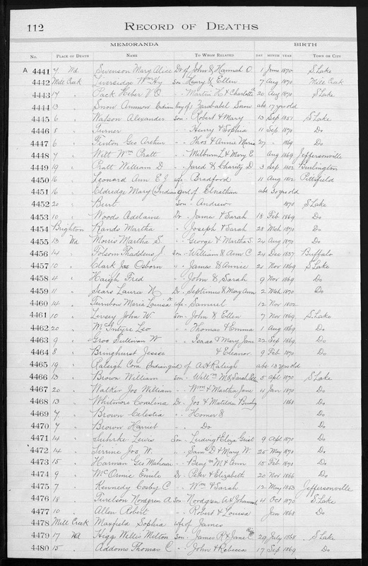
    <summary type="html"><![CDATA[<p><strong><em>A Latter-day Saint family adopted Mary Mountain under the “Act for the Further Relief of Indian Slaves and Prisoners.” Many families in the 1850s claimed this policy in order to justify their actions of legally indenturing indigenous children. Mary Mountain’s story illustrates the effects of this act, which many native children commonly experienced.</em></strong></p><img src="https://www.intermountainhistories.org/files/fullsize/c17e79facb4b24b93731db58d42269ab.jpg" alt="Record of Mary Mountain’s death." /><br/><p>Beginning with their 1847 arrival in the Great Basin and continuing through the Civil War era, Latter-day Saint settlers adopted (though legal documents of the time used the term “indentured”) indigenous children by purchasing them from slave-trading tribes such as the Utes. Mary Mountain represents one of many native children indentured according to the “Act for the Further Relief of Indian Slaves and Prisoners” passed by the Legislative Assembly of the Territory of Utah in 1851. This act legalized the indentured servitude of indigenous children in order to rescue them from Ute captivity. Another intention for this act was to redeem the children by encouraging them to adopt Christian beliefs and thereby transform into what Book of Mormon scripture describes as “a pure and a delightsome people.”</p><p>Through this act, any white settler living in Utah Territory with an “Indian prisoner, child, or woman, in [their] possession, whether by purchase or otherwise” could receive approval by a probate judge to indenture the child up to twenty years. Those involved agreed to send children between the ages of seven and sixteen to school for three months of the year. In his proclamation regarding the “Act for Further Relief,” Brigham Young declared that although they should treat indigenous people with humanity, they must not “elevate them... to an equality with those whom nature and nature's God has indicated to be their masters, their superiors.”</p><p>Ruth and Elnathan Eldredge adopted Mary Mountain in 1849 after Elnathan found her standing alone after a skirmish between the Timpanogos tribe and the Mormon militia. Although her date of birth remains unknown, the Eldredges claimed Mary was around nine years old when they found her; they also gave her the name “Mary Mountain.” Mary’s biography reveals that the Eldredges treated her well as she learned to set the table, fetch water from the stream, and tend to the Eldredges’ baby. Although the Eldredges adopted Mary, Ruth Eldredge recorded that she was “solid and dependable in practical things, but not a daughter for solace and comfort in things near her heart.” As a consequence of isolation from her native culture, Mary grew to fear members of her own tribe and ran and hid whenever they passed by the Eldredge home. Even as Mary grew older and indigenous men attempted to court her, she would have nothing to do with them, and when white men came to court her, Elnathan Eldredge advised against it due to her indigenous heritage.</p><p>Mary Mountain died from tuberculosis around the age of thirty and was buried in the Salt Lake City Cemetery. Unfortunately, many indigenous children adopted into Latter-day Saint homes also faced early deaths from exposure to European pathogens. The “Act for the Further Relief of Indian Slaves and Prisoners” represents a unique point in Utah’s history, combining hopeful intentions with sometimes fatal results.</p><p><em><strong><a href="https://www.intermountainhistories.org/items/show/407">For more (including 3 images) view the original article</a></strong></em></p>]]></summary>
    <published>2020-03-17T01:32:45+00:00</published>
    <updated>2026-04-17T19:32:08+00:00</updated>
    <link rel="alternate" type="text/html" href="https://www.intermountainhistories.org/items/show/407"/>
    <id>https://www.intermountainhistories.org/items/show/407</id>
    <author>
      <name>Taylor Tree, Brigham Young University</name>
    </author>
  </entry>
  <entry>
    <title type="html"><![CDATA[Chief Peteetneet and Mormon Settlers]]></title>
    <summary type="html"><![CDATA[<p><strong><em>Chief Peteetneet lived in the area of modern-day Payson, Utah and experienced vacillant relations with Latter-day Saint settlers. Despite various conflicts, he finally achieved his goal of residing peacefully on Native land.</em></strong></p><img src="https://www.intermountainhistories.org/files/fullsize/b2da0e98dedcce28c239d87f8068cd60.jpg" alt="Statue of Chief Peteetneet and the Peteetneet Museum" /><br/><p>Westward expansion for The Church of Jesus Christ of Latter-day Saints largely occurred in the year 1850 under the leadership of Brigham Young, a governor of Utah Territory and prophet of the Church. He sent pioneer families to various parts of Utah Territory to settle the regions by building ditches, forts, and homes. In present-day Payson, settlers named one settlement “Peteetneet” after a local Ute chief. Relations between the settlers and Chief Peteetneet fluctuated throughout the years.</p><p>The pioneer settlers took possession of Ute land and game resources, inciting the natives to take settlers’ horses and cattle for their own use. In response to this presumably unwarranted theft, Brigham Young ordered a militia to drive out all local Utes. A violent fight ensued and after it ended, U.S. Army surgeon Dr. James Blake decapitated three Utes for scientific research. Upset by such disrespectful treatment of his people, Chief Peteetneet confronted Latter-day Saint leaders at Fort Utah. Brigham Young instructed Big Chief to write to Chief Peteetneet and several others about coexistence and cooperation. The letter states, “I know the difference between good Indians and bad Indians... we can live with good Indians, and will do them good… Indians must do as God tells them, through Mormon chief, and be good and learn to work, raise grain, and learn all Mormons know.” Over the years, Chief Peteetneet wavered between welcoming these religious settlers and wishing they would leave. In 1854, he expressed a desire to return to his lands even if that meant living near the settlers and accepting Brigham Young’s invitation to learn to build houses, raise grain, and live in peace.</p><p>When the Latter-day Saints faced war with the U.S. Army in 1857, they considered the Utes their allies. Chief Peteetneet, however, stated that if the Latter-day Saints intended to fight the United States, the Utes would not help them in order to avoid battles on Ute land. Additionally, Chief Peteetneet said he was a friend to both Americans and Latter-day Saints and was simply doing what Brigham Young told him to do by raising grain and avoiding conflict.</p><p>Another dispute between the Latter-day Saints and Chief Peteetneet arose with the arrival of Indian agent Garland Hurt. Hurt openly hated the pioneer settlers and gave Chief Peteetneet gifts that surpassed the trading relations the Utes had with the settlers. Brigham Young suspected that Hurt was exerting “an influence for evil” over Chief Peteetneet to make relations difficult for the Latter-day Saints. However, although Chief Peteetneet did not always get along with Brigham Young’s settlers, he continued to treat them with respect.</p><p>As Hurt’s relationship with the Latter-day Saints continued to deteriorate, he fled the territory alongside some Utes. Chief Peteetneet agreed to stay behind to scatter any government cattle and horses and catch up with Hurt’s group soon after. Amidst the confusion of scattering government resources, Chief Peteetneet encountered several Utes who had stolen some of the settlers’ cattle and ordered that they honorably return them. Chief Peteetneet protected and preserved Brigham Young’s settlers on several other occasions.</p><p>The settlers eventually built a house for Chief Peteetneet and his wife (fondly nicknamed Old Lady Peteetneet), which is now known as the Payson Indian Farm. Chief Peteetneet achieved his wish of peacefully living on Ute land.</p><p><em><strong><a href="https://www.intermountainhistories.org/items/show/403">For more (including 3 images) view the original article</a></strong></em></p>]]></summary>
    <published>2020-03-09T21:20:52+00:00</published>
    <updated>2026-04-17T19:32:08+00:00</updated>
    <link rel="alternate" type="text/html" href="https://www.intermountainhistories.org/items/show/403"/>
    <id>https://www.intermountainhistories.org/items/show/403</id>
    <author>
      <name>Karen Samuelson Ricks, Brigham Young University</name>
    </author>
  </entry>
  <entry>
    <title type="html"><![CDATA[Mapleton, Utah&#039;s First LDS Meetinghouse]]></title>
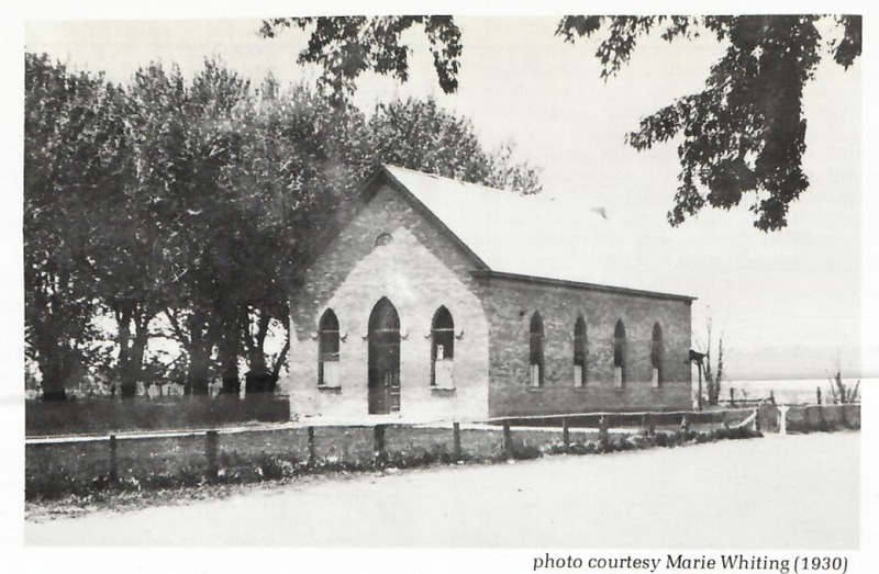
    <summary type="html"><![CDATA[<p><strong><em>The first dedicated LDS meetinghouse in Mapleton, Utah was built in 1893. </em></strong></p><img src="https://www.intermountainhistories.org/files/fullsize/dbc6892c395952adcb3d5ca8b045f5ff.jpg" alt="Photo of the First Chapel" /><br/><p>The community of Union Bench was an extension of Springville, but the growing community that would soon become Mapleton hit a turning point when they built their first dedicated public meetinghouse for The Church of Jesus Christ of Latter-Day-Saints. Settlement began in 1856 and the small church branch met in a public schoolhouse located near the center of town. The schoolhouse, even with an addition made to provide more space, did not last forever. The branch was officially organized into a ward in 1888. Around this time, a larger meetinghouse was needed for both the school and the church.</p><p>As a new school was finished in 1890 and the church meetings moved there the members of the Church recognized they needed a dedicated meetinghouse. A committee was formed to find a building site and local member Matilda Streeper offered to donate one acre of land if construction of the new church began immediately. Construction on the church began in 1889, the church was dedicated in 1892, and in 1893 it was completed and meetings started. The meetinghouse was a stepping-stone into Union Bench becoming a town. As the new school and church were completed, the community pulled together to petition for township. As the Mapleton ward, named after a grove of trees near the canyon, made up a majority of the community’s population, the town came to be known as Mapleton, Utah.</p><p>The meetinghouse stood and satisfied the needs of the ward for many years. The building was sturdy and any hazards to it were swiftly taken care of, but as Mapleton continued to grow after gaining town status the need for a bigger meetinghouse arose. In the 1930s, the Great Depression hit the town and the population struggled. The church and town leaders worked closely together to combat poverty and support the struggling families by finding different work projects to provide work receipts that could be exchanged for food. One of these projects was the demolition of the old meetinghouse and the construction of a new one, which is still standing. The new chapel cost $35,000, half of which was donated by the local community. The chapel was completed in 1938 and dedicated for use in 1941 and is still in use today. You can find a plaque with a brief history outside the chapel, as well as historical photos on the walls inside which convey some of the heritage of the early Mapleton residents.</p><p><em><strong><a href="https://www.intermountainhistories.org/items/show/390">For more (including 4 images) view the original article</a></strong></em></p>]]></summary>
    <published>2020-02-18T01:20:45+00:00</published>
    <updated>2026-04-17T19:32:07+00:00</updated>
    <link rel="alternate" type="text/html" href="https://www.intermountainhistories.org/items/show/390"/>
    <id>https://www.intermountainhistories.org/items/show/390</id>
    <author>
      <name>Logan Goulding, Brigham Young University</name>
    </author>
  </entry>
  <entry>
    <title type="html"><![CDATA[The Black Hawk War]]></title>
    <summary type="html"><![CDATA[<p><strong><em>The Black Hawk War pitted the Mormon settlers against Native Americans in Utah Territory. Many raids took place, in which many lives were lost. As the war escalated, the relationship between the Mormon settlers and the Native Americans increased in separation. Finally, the war came to an end with a treaty that would start to mend the relationship between the Mormon settlers and the Native Americans.</p></strong></p><img src="https://www.intermountainhistories.org/files/fullsize/df1041ef2dbd946b88cdda14d537c2a6.jpg" alt="James Russell Ivie" /><br/><p>The Black Hawk War grew from severe tension between the Mormon settlers and the Native Americans in the Utah Territory. When the settlers arrived in the Utah Territory many drove the wild animals that the Natives hunted into the mountains, and allowed their cattle, horses and sheep to eat the grass, which was a major food source for the Native Americans. The Natives viewed the settlers as the cause for their lose of resources, and often took domesticated livestock in return.</p><p>These interactions resulted in violence, with both sides making declarations of war for many reasons, such as protecting their families and avenging the loss of their brethren. The Black Hawk War officially started the day the Civil War ended in 1865. During this war many raids took place, in which many lives were lost, with the majority of fatalities being Native Americans. </p><p>At the end of the war in the year 1868, Black Hawk offered a peace treaty to the Mormon settlers, which to some Native Americans was not welcomed, but in the end was accepted by both sides. However, the battles and the raids that took place during the Black Hawk War only made the relationship between the settlers and the Native Americans worse. This treaty seemed to be the first step that was accepted by both sides, which led to the start of the healing process of their relationship. Many saw this treaty as the official ending of the Black Hawk War, while others believed that the war ended when Black Hawk left to go to live in another part of the Utah Territory. </p><p><em><strong><a href="https://www.intermountainhistories.org/items/show/307">For more (including 2 images) view the original article</a></strong></em></p>]]></summary>
    <published>2019-02-22T07:03:57+00:00</published>
    <updated>2026-04-17T19:32:05+00:00</updated>
    <link rel="alternate" type="text/html" href="https://www.intermountainhistories.org/items/show/307"/>
    <id>https://www.intermountainhistories.org/items/show/307</id>
    <author>
      <name>Rachel Lee, Brigham Young University</name>
    </author>
  </entry>
  <entry>
    <title type="html"><![CDATA[John Moses Browning Home<br />
]]></title>
    <summary type="html"><![CDATA[<p><strong><em>This home was that of John Moses Browning who earned international prominence for his revolutionary designs of sporting and military firearms.</p></strong></p><img src="https://www.intermountainhistories.org/files/fullsize/e2e8e8fc9df8d30b9a356b39ed5ef3e7.jpg" alt="John M. Browning Home" /><br/><p>John Moses Browning (1855-1926) “was world renowned for his genius as an inventor, and took out more patents for improvements in fire-arms than any other man in the world.” A native of Ogden, Utah, John “was attached to the city and place of his birth.” Indeed, it could be said that “no one man did more to make the name of this city and state known over the world than John M. Browning.”</p><p>John was the son of Jonathan Browning and Elizabeth Caroline Clark, one of his father’s three wives. The Brownings had moved to Utah as part of the migration of members of The Church of Jesus Christ of Latter-Day Saints. Jonathan was a gunsmith; as a young boy, John spent hours in his father’s shop. He filed his first patent for the “J.M. Browning Single Shot Rifle” in 1879. (Eventually he held 128 patents.) The year before, he had co-founded with his younger brother the John Moses and Matthew Sandifer Browning Company, later renamed Browning Arms Company. The firearms they designed caught the attention of the Winchester Repeating Arms Company. From 1883, Browning worked in partnership with Winchester to produce a series of rifles and shotguns.</p><p>About 1900, Browning invented the first auto-loading shotgun and moved his family into their new home, designed by architect Sam Whittaker. The home  is two and a half stories. Its exterior is made from a combination of sandstone, smooth bricks and rippled natural looking brick. Its beautiful exterior is enhanced by big, clear, intricately shaped windows. </p><p>The home remained the residence of the family until around 1940 when it was converted into an apartment building.The building was purchased by the Y.W.C.A. in 1946 and was used as a women’s shelter until it was purchased by a law firm and used as office space. The home was listed on the National Register of Historic Places in 1973. In 2001 a family moved in and renovated the home then put it up for sale in 2011.</p><p>The home is privately owned so access is unfortunately restricted but it is a great reminder of the man who changed the history of firearms forever and left a lasting mark on the history of Ogden and of Utah. </p><p><em><strong><a href="https://www.intermountainhistories.org/items/show/268">For more (including 5 images) view the original article</a></strong></em></p>]]></summary>
    <published>2019-02-02T06:21:37+00:00</published>
    <updated>2026-04-17T19:32:04+00:00</updated>
    <link rel="alternate" type="text/html" href="https://www.intermountainhistories.org/items/show/268"/>
    <id>https://www.intermountainhistories.org/items/show/268</id>
    <author>
      <name>Brock Bergquist, Weber State University</name>
    </author>
  </entry>
  <entry>
    <title type="html"><![CDATA[Ogden Canyon Lime Kiln<br />
]]></title>
    <summary type="html"><![CDATA[<p><strong><em>The lime kiln in Ogden Canyon has been restored as a reminder of the importance of such kilns in the building of structures in the Ogden area.</em></strong></p><img src="https://www.intermountainhistories.org/files/fullsize/132c267109bd5c28a0aeee9b0f04d526.jpg" alt="Restored Lime kiln" /><br/><p>The lime kiln, built in 1865, was one of several kilns that produced lime for mortar, plaster, and other materials essential in many of Ogden’s early buildings. It resembles a large fireplace with a pot in the center.  Limestone from the large natural deposits in Ogden Canyon was layered with coal or wood and the mixture was heated over an open flame and the resulting lime was crushed to powder. The lime was sold from large bins in downtown Ogden to local builders.  After Portland cement became the favored material for buildings, the lime kilns were abandoned.</p><p>According to Moroni Thomas who wrote his history in 1934, his father J.M. Thomas helped build this lime kiln, the second in Ogden Canyon.  The Utah Powder Mills were located just north of the kiln. There were nine separate buildings used as crushing mills, amalgamating houses, and mixing press houses in the manufacture of black powder which was used for blasting in the early mines of the area. However, when the explosion destroyed the compound in 1883, it was never rebuilt.</p><p>By the time the Ogden Canyon Club discussed saving the kiln, not much of it was left.  Most of the original stones were gone.  With the help of small grants, the Ogden Canyon Club and the Weber County Heritage Foundation were able to hire brother and sister team Cody and Kellie Wright to rebuild the kiln, with help from a stonemason, Brock Cheney, and students from the local technical college. </p><p>The small amounts of money raised spread the restoration work over several years, but a final grant of $30,000 from the Weber County RAMP fund provided enough funds to finish the job.  The lime kiln was dedicated in 2008 with a ceremonial fire – the first in over a century.  The patience and hard work put into this project serve as an important example of what can be done for other landmarks that might otherwise be lost to history.</p><p><em><strong><a href="https://www.intermountainhistories.org/items/show/264">For more (including 5 images) view the original article</a></strong></em></p>]]></summary>
    <published>2019-01-26T04:46:59+00:00</published>
    <updated>2026-04-17T19:32:04+00:00</updated>
    <link rel="alternate" type="text/html" href="https://www.intermountainhistories.org/items/show/264"/>
    <id>https://www.intermountainhistories.org/items/show/264</id>
    <author>
      <name>Amber Howard, Weber State University</name>
    </author>
  </entry>
  <entry>
    <title type="html"><![CDATA[Box Elder Stake Tabernacle<br />
]]></title>
    <summary type="html"><![CDATA[<p><strong><em>The Box Elder Tabernacle of the Church of Jesus Christ of Latter Day Saints is a fine example of Neo-Gothic architecture. It was saved from demolition and renovated in 1985.</em></strong></p><img src="https://www.intermountainhistories.org/files/fullsize/0dd08a07287acb10472ce0a9e8609fff.jpg" alt="Box Elder Tabernacle" /><br/><p>Brigham Young, President of The Church of Jesus Christ of Latter-Day Saints,  selected the site for the Box Elder State Tabernacle in 1865. However, construction did not begin until 1876 under the direction of Brigham City’s first Stake President, Lorenzo Snow. The building was not finished until 1890 under the leadership of Stake President Charles Kelley.  The architect was probably Truman 0. Angel, Jr. or his father, one of the more famous L.D.S. Church architects. With volunteer labor, field stone was collected nearby and lumber was hauled from the mountains, sawed and delivered to the site. The structure was 50 feet by 95 feet with a tower rising above each of the four corners. The seating capacity was 1200.</p><p>One Sunday afternoon in 1896, the building burned down, leaving only the four walls standing.  According to the local paper, the Brigham City Bugler, it took only a half hour for the tabernacle to turn into “a mass of furious, crackling flames.” By 2:30 in the afternoon, the building was nothing more than a smoking, blackened hulk. The fire had even stripped the plaster from the walls and floating embers from the tabernacle blaze had touched off other fires around town. </p><p>It was rebuilt under the leadership of Stake President Rudger Clawson in a more elaborate neo-Gothic style. Sixteen brick buttresses were added to the exterior with steeples topping each one. A major tower was added to the front.  Inside the building a vestibule was added and the seating capacity increased by 400. The new structure was dedicated in March of 1897. A reporter for the Brigham City Bugler wrote, “What on the day of the great fire appeared a calamity, will tomorrow be looked upon as a great blessing -- there is really no comparison between the old and the new.”</p><p>As the L.D.S. Church built more stake centers in the Brigham City area, the tabernacle became less prominent. It was added to the National Register of Historic Places in 1971. Although some talked of tearing it down, the building was restored and renovated from 1985 to 1987. To this day many come to tour and praise this celebrated building with its long history of trials and triumphs. </p><p><em><strong><a href="https://www.intermountainhistories.org/items/show/259">For more (including 3 images) view the original article</a></strong></em></p>]]></summary>
    <published>2019-01-25T04:23:19+00:00</published>
    <updated>2026-04-17T19:32:04+00:00</updated>
    <link rel="alternate" type="text/html" href="https://www.intermountainhistories.org/items/show/259"/>
    <id>https://www.intermountainhistories.org/items/show/259</id>
    <author>
      <name>Jocelyn St. Laurent, Weber State University</name>
    </author>
  </entry>
  <entry>
    <title type="html"><![CDATA[Hole-in-the-Rock]]></title>
    <summary type="html"><![CDATA[<p><strong><em>Mormon pioneers settled Bluff, Utah, from 1879-1880.  To reach their destination they chose a ‘short cut’ through Hole-in-the-Rock.  Traveling through the passage proved much more difficult and time-consuming than anticipated.</em></strong></p><img src="https://www.intermountainhistories.org/files/fullsize/c8c36b21f93fc9ce2adb1e9eb3fd3246.jpg" alt="Dugway Remnants" /><br/><p>Mormon settlers of Bluff, Utah, crossed the high desert of the Colorado Plateau and the Colorado River in 1879 on what is now known as the Hole-In-the-Rock trail. Brigham Young had called a group of southern Utah Mormons to settle southeastern Utah because few Mormon families lived east of the Colorado River. The Mormons organized quickly and decided on a route from Escalante, Utah, to a remote section of southeastern Utah. Desert terrain, canyon country, and the Colorado River all made the journey difficult..</p><p>After a relatively easy journey south of Escalante towards the Colorado River, they ran into trouble. The canyon country surrounding the Colorado River had sheer cliffs that were difficult to descend. They sent out scouts and chose a ‘short cut’ through an actual hole, they dubbed Hole-in-the-Rock. At the top of a canyon that descended to the Colorado River, there was a relatively large navigable passageway. The trail was marked by a large hole that was wide and tall enough for a few men, but not wide enough for a wagon to pull through. They sent a group back to obtain dynamite and other equipment. With great effort they blasted away the edges of the hole. The gap opened wide enough for the wagons to travel through.</p><p>However, the descent down from the top of the cliff was difficult. The hole opened to a sheer cliff far from the river below. To descend to the canyon floor, they built a ‘floating’ road called a dugway. They bored holes into the cliff to drive metal spikes into the wall, then placed strong tree branches over the spikes and piled up rocks underneath to finish the road. Eventually they made it far enough down the side of the cliff that a dugway was no longer needed, but the terrain was still too difficult for the animals to safely walk over. They carved stairs into the solid rock to make it easier for their horses and cattle to maneuver. The rock stairway was the last part of the trail that led to the water’s edge.</p><p>Once the party made it to the bottom of the canyon, they had to cross the Colorado River.  Using a ferry that could fit two wagons at a time, they managed to get everyone across. Their journey was not over, but the most difficult phase was done. They proceeded through more canyon country and settled Bluff, Utah.</p><p>Today, some of the staircase is under Lake Powell, but most of the dugway along the cliff is still visible. One can hike down the trail from the top of the canyon through the Hole-in-the-Rock. The trail is also accessible below by boat from Lake Powell. </p><p><em><strong><a href="https://www.intermountainhistories.org/items/show/69">For more (including 4 images) view the original article</a></strong></em></p>]]></summary>
    <published>2017-06-09T19:23:54+00:00</published>
    <updated>2026-04-17T19:31:59+00:00</updated>
    <link rel="alternate" type="text/html" href="https://www.intermountainhistories.org/items/show/69"/>
    <id>https://www.intermountainhistories.org/items/show/69</id>
    <author>
      <name>Alex Anthony, Northern Arizona University</name>
    </author>
  </entry>
  <entry>
    <title type="html"><![CDATA[Emigration Canyon: The Arrival of the Saints]]></title>
    <summary type="html"><![CDATA[<p><strong><em>In late July, 1847, the first party of Mormon pioneers entered the Salt Lake Valley, traveling through Emigration Canyon in the Wasatch Mountains. Within two days, the pioneers erected a permanent settlement at City Creek, near modern-day Temple Square in Salt Lake City. The arrival of the Mormons commenced a new era of history in Utah, attracting thousands of eager Mormon settlers to cultivate and transform the land. </em></strong></p><img src="https://www.intermountainhistories.org/files/fullsize/98f4d1a60528ad40bcbebc195b6bd91f.jpg" alt="Emigration Canyon" /><br/><p>On July 21st, 1847, after a grueling journey of 108 days, Erastus Snow and Orson Pratt had the distinction of being the first Mormon pioneers to descend from Emigration Canyon into the Salt Lake Valley, after following the remnants of a rough road through the Wasatch Mountains most recently blazed by the Donner-Reed Party. Pratt’s words capture the grandeur of that moment, “After issuing from the mountains . . . and beholding, in a moment, such an extensive scenery open before us, we could not refrain from a shout of joy . . . the grand and lovely scenery was in our view”. Although the Mormons were not the first Euro-Americans, or even emigrants, to pass through Emigration Canyon into the Salt Lake Valley, their arrival represented a dynamic transition in the history of Utah, which the Mormons would dominate from that point onward. </p><p>The day after Snow and Pratt first glimpsed and scouted the valley, the Mormon pioneers already began to reshape both the route through Emigration Canyon and the valley itself. On July 22nd, a crew from the advance wagon party lead by Stephen Markham cut a road through Donner Hill in just four hours, creating quick and suitable route around the hill that taxed the Donner-Reed Party’s animals the previous year. On the same day, led by Orson Pratt, eight members of the advance party made their way down into the Salt Lake Valley to locate a suitable location for planting. Finding the soil to be more fertile closer to the mouth of Emigration Canyon, the party discovered an area near City Creek, a “beautiful creek of pure water” according to Pratt, that would become the first settling point for the Mormon pioneers. On July 23rd, while the advance company began plowing acres of land and damming City Creek, Brigham Young, ill with “mountain fever”, made the journey over Little and Big Mountains and camped near what Orson Pratt called Last Creek, prepared to take the final 6 miles of the journey the following day.</p><p>On July 24th, now celebrated as Pioneer Day, the ailing Brigham Young descended into the Salt Lake Valley in one of Wilford Woodruff’s wagons, entering sometime after noon, and as recorded in Woodruff’s journal, “expressed his full satisfaction in the Appearance of the valley as A resting place for the Saints.” Brigham Young triumphantly entered the City Creek camp at 2 PM, finding 5 acres of potatoes planted, which the Saints irrigated at noon from the creek, thus beginning the great work of molding the Salt Lake Valley into a suitable home for the Mormons. Although the infamous words of Brigham Young, “this is the place” were not recorded until 33 years later by Wilford Woodruff in a speech commemorating the Mormon church’s 50th anniversary, “This is the Place” monument, completed in 1947 by Brigham Young’s grandson Mahonri Young, immortalized the Mormons’ arrival into the Salt Lake Valley on those July days in 1847, which would transform the land and history of Utah forever.</p><p><em><strong><a href="https://www.intermountainhistories.org/items/show/48">For more (including 3 images) view the original article</a></strong></em></p>]]></summary>
    <published>2017-05-24T01:05:38+00:00</published>
    <updated>2026-04-17T19:31:58+00:00</updated>
    <link rel="alternate" type="text/html" href="https://www.intermountainhistories.org/items/show/48"/>
    <id>https://www.intermountainhistories.org/items/show/48</id>
    <author>
      <name>Luke Eckstrom, Brigham Young University</name>
    </author>
  </entry>
</feed>