<?xml version="1.0" encoding="UTF-8"?>
<feed xmlns="http://www.w3.org/2005/Atom">
  <title type="text">Intermountain Histories</title>
  <updated>2026-04-17T19:32:17+00:00</updated>
  <generator uri="http://framework.zend.com" version="1.12.20">Zend_Feed_Writer</generator>
  <link rel="alternate" type="text/html" href="https://www.intermountainhistories.org/"/>
  <link rel="self" type="application/atom+xml" href="https://www.intermountainhistories.org/items/browse?output=rss2"/>
  <id>https://www.intermountainhistories.org/</id>
  <author>
    <name>Intermountain Histories</name>
    <uri>https://www.intermountainhistories.org</uri>
  </author>
  <link rel="hub" href="https://pubsubhubbub.appspot.com/"/>
  <entry>
    <title type="html"><![CDATA[The Yankee Fork Mining District]]></title>
    <summary type="html"><![CDATA[<p><strong><em><span style="font-weight:400;">Custer County, Idaho is home to one of the best preserved gold dredges in the country–and a rich mining history that ushered in new life and opportunity. </span></em></strong></p><img src="https://www.intermountainhistories.org/files/fullsize/f3100d51405a82a8c2925197e302b71a.jpg" alt="Yankee Fork Gold Dredge" /><br/><p><span style="font-weight:400;">Placer gold, extractable by hand with little equipment, was discovered in Idaho in 1860 by E. D. Pierce. Pierce became fixated with the idea of mining on the Nez Perce territory in Northern Idaho and corners of Washington and Oregon. He eventually disregarded the law which prohibited mining on Native American lands and chose to proceed with his plans, launching the region into a new era of exploration, excavation, and the boomtowns that sprouted up in response.</span>
<span style="font-weight:400;">Previous to the discovery of gold, settlements in the region were largely made up of various Christian missionary enterprises and Mormon communities. Congregationalist-Presbyterians and Catholics were among the first to travel to Idaho in the 1830s, introducing christianity to the Nez Perce and establishing settlements in the area. Groups of Mormon settlers traveled north from the Salt Lake Valley into what would become Idaho, first in 1855, and progressively more in the following years. </span>
<span style="font-weight:400;">Idaho became a U.S. territory in 1863, and there was growing interest in the land for more than just religious reasons. As gold speculators made their way through the territory they found vast riches around Yankee Fork, a river in central Idaho’s Custer County. It wasn’t long until a mining district–a section of rural land designated for mining–was established around the river. By 1882, annual gold and silver production in Idaho had reached 3.5 million dollars, and one-third of that profit came from placer deposits in the rivers of Custer County. Additionally, there was an abundance of ore, another source of wealth for hardrock mining in Idaho. However, many of these spoils were in the riverbed which made them difficult to extract without the proper equipment. </span>
<span style="font-weight:400;">The Yankee Fork Mining District is most famous for its dredge, designed to extract gold and silver from riverbeds. The use of industrial machines, rather than physical labor, was first introduced in the late nineteenth century–but it wasn’t until 1940 that the construction of the Yankee Fork Gold Dredge was complete. It was no small enterprise at 112.5 feet long and 64 feet high, with a bucket system and sluice boxes to collect and sift through elements. Even though mining stopped during World War II due to the nationwide ban on non-essential mining, work at the dredge picked up again in 1946. The second stint didn’t last long; the dredge was shut down for good in 1952 when the once abundant minerals ran dry. Although it operated for less than ten years, the Yankee Fork dredge managed to produce over 1 million dollars. Today it is a site for summer tourists and one of the best preserved dredges in the U.S. Although a relic of the past, Custer County is still host to 952 mines for the extraction of silver, gold, lead, zinc, and copper.  </span></p><p><em><strong><a href="https://www.intermountainhistories.org/items/show/804">For more (including 5 images) view the original article</a></strong></em></p>]]></summary>
    <published>2024-05-16T01:28:14+00:00</published>
    <updated>2026-04-17T19:32:17+00:00</updated>
    <link rel="alternate" type="text/html" href="https://www.intermountainhistories.org/items/show/804"/>
    <id>https://www.intermountainhistories.org/items/show/804</id>
    <author>
      <name>Megan Bailey, Brigham Young University</name>
    </author>
  </entry>
  <entry>
    <title type="html"><![CDATA[Golden: A Ghost Town]]></title>
    <summary type="html"><![CDATA[<p><strong><em><span style="font-weight:400;">In an overgrown cemetery, amidst tombstones and memorabilia, a child’s white metal bed frame sits above a grave. Golden, New Mexico–population zero–is a ghost town in more ways than one. </span></em></strong></p><img src="https://www.intermountainhistories.org/files/fullsize/e67fd8700f683d9e53b557c2c957ca2f.jpg" alt="San Francisco de Asis Catholic Church" /><br/><p><span style="font-weight:400;">Today the tiny Santa Fe community of Golden is known for the gold rush that it was named for, but before the gold Navajo peoples found prosperity in turquoise. The road running from Albuquerque to Santa Fe, which is now part of New Mexico 14, is still aptly referred to as the “Turquoise Trail.” In the 14th century Spanish Conquistadors made their way to the region of Mexico that would later become New Mexico and Arizona. For several hundred years they traded goods, mined, and colonized the land. </span>
<span style="font-weight:400;">It is said that the gold rush didn’t really begin in New Mexico until it was declared an American state, but nearly one-hundred years earlier in 1825 the community of Golden had its day in the sun. When Mexico gained independence from Spain in 1821, the Santa Fe trail became open to Americans for trading purposes–creating an influx of American settlers to the area, who had been few and far between during the Spanish years. Trading opportunities, cattle herding, gold, and the exciting prospect of “new” land drew Americans in from surrounding U.S. territories and states. Gold was discovered in the land just north of the San Pedro mountains and a mining district blossomed. Within the next few decades a general store, a post office, a public school, and quite a few saloons, were built as well as a Catholic church–which is now the most photographed church along the Turquoise Trail. </span>
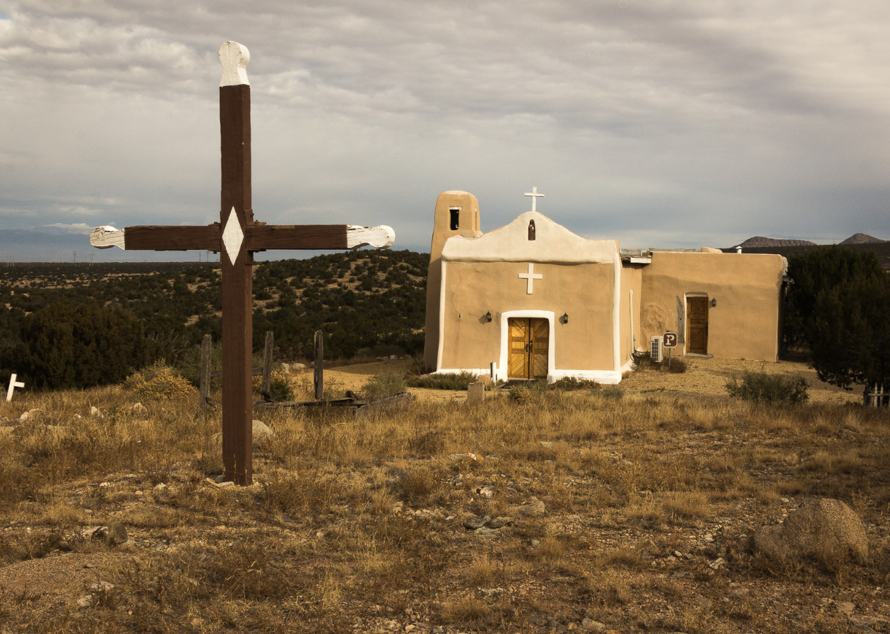
<span style="font-weight:400;">San Francisco de Asis Catholic Church, named after Saint Francis of Assisi, was built around 1830. The adobe brick plaster makeup of the church has held up well over the years, and the white painted crosses still look as bright as ever. The churchyard is home to the bodies of those who died in the fleeting time of Golden’s own “life.” Although the church provides a glimpse into the past, it isn’t completely dormant. Beloved by those who explore the grounds on their way through town, and welcoming to Sunday tourists who attend church services.</span>
<span style="font-weight:400;">The era of growth and excitement in the community was short-lived and ended almost as suddenly as it had begun. When the 1825 gold rush era ended, there was little reason to stay. The few who remained resorted primarily to agriculture to make their living. There was a dwindling and largely fruitless attempt by some remaining residents to dig up the last of the gold, but there was only so much to be found before even the most stubborn of them abandoned the pursuit. A hundred years after the initial gold rush there were so few people remaining that Golden lost its township status. In 2021 the census reported a population of zero residents of Golden, but the Turquoise Trail continues as a scenic route for road trips and the church with its overgrown cemetery stands as a monument–a living memory of all that once was. </span></p><p><em><strong><a href="https://www.intermountainhistories.org/items/show/799">For more (including 5 images) view the original article</a></strong></em></p>]]></summary>
    <published>2024-05-15T19:52:11+00:00</published>
    <updated>2026-04-17T19:32:17+00:00</updated>
    <link rel="alternate" type="text/html" href="https://www.intermountainhistories.org/items/show/799"/>
    <id>https://www.intermountainhistories.org/items/show/799</id>
    <author>
      <name>Megan Bailey, Brigham Young University</name>
    </author>
  </entry>
  <entry>
    <title type="html"><![CDATA[Idaho’s Territorial Capital Dispute]]></title>
    <summary type="html"><![CDATA[<p><strong><em>Lewiston was Idaho's first territorial capital, but the title was short-lived. Many disputes over moving the capital down to Boise ensued between the people of Lewiston and the people of Boise, contributing to a longstanding divide between northern and southern Idaho.</em></strong></p><img src="https://www.intermountainhistories.org/files/fullsize/acc53b1a3c757d53c6ac8a90857a5ee8.jpg" alt="First" /><br/><p>A nineteenth-century dispute over where to place the state capital dispute helped create a regional divide that persists in Idaho to this day. It all started when westward settlers found gold in 1860, leading many to migrate to the Rocky Mountains in hopes of striking it rich. Settlers found gold in the Clearwater River, in northern Idaho, and some formed mining camps, one of which was Lewiston. As the settler population grew, many in the area called for establishing a seat of United States government closer than Olympia, Washington. In response, in March 1863, territorial governor William H. Wallace pronounced Lewiston the capital of Idaho. Wallace chose this location because in addition to the gold, there was already an established transportation and communication system that linked northern Idaho to other U.S. states and territories.
After the discovery of gold in 1862 in the Boise Basin, however, eager settlers rushed to the southern part of the territory. At the same time, gold had depleted up north in Lewiston, even further accelerating the southward migration. With most of the settler population now residing in the south, moving the capital seemed logical, especially since mountainous terrain made traveling between Boise and Lewiston difficult.
This turned out to be easier said than done, however. The territorial legislature, primarily made up of representatives from northern Idaho, failed the first initiative to change Idaho’s capital. However, in 1864 Idaho’s number of legislative representatives changed to accommodate the difference in population, leaving three representatives for the north and four for the south. This change in political power—plus pressure from H. C. Riggs, one of Bosise’s founders—convinced acting governor Caleb Lyon to move the capital to Boise. On November 23, 1864, Riggs introduced a bill to make Boise the capital. It passed six days later, and Lyon signed it into law.
Rather than fix the problem, this may have only made it worse. Governor Lyon fled to nearby Walla Walla, Washington, and sent a trusted official to retrieve the official documents from the acting secretary of Lewiston. After a stalemate over who had rights to the papers, and where the capital would officially reside, President Lincoln’s territorial secretary C. DeWitt Smith went to serve as acting governor of Idaho. With help from Fort Lapwai soldiers, Smith obtained the documents and traveled to Boise, where he put the new law into effect.
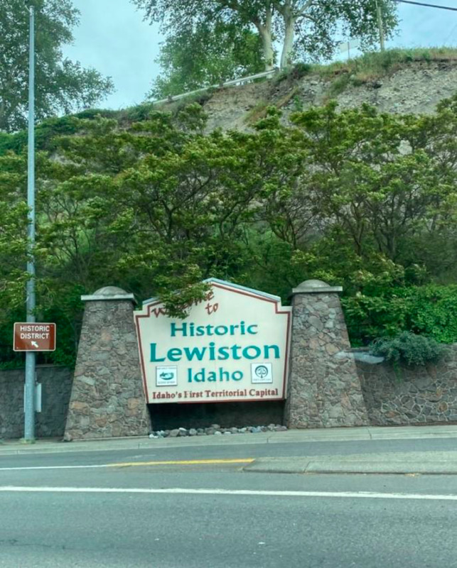
In the end, moving the capitol from Lewiston to southern Idaho left its residents with a sense of lost pride. This sparked a cultural divide between northern and southern Idaho that continues to this day. To this day, downtown Lewiston hosts a sign proclaiming the city “Idaho's First Territorial Capital,” demonstrating that the residents remember their city’s history and will not let people forget Idaho’s original territorial capital.</p><p><em><strong><a href="https://www.intermountainhistories.org/items/show/628">For more (including 3 images) view the original article</a></strong></em></p>]]></summary>
    <published>2022-06-30T20:51:21+00:00</published>
    <updated>2026-04-17T19:32:13+00:00</updated>
    <link rel="alternate" type="text/html" href="https://www.intermountainhistories.org/items/show/628"/>
    <id>https://www.intermountainhistories.org/items/show/628</id>
    <author>
      <name>Dawson Packwood, College of Idaho</name>
    </author>
  </entry>
  <entry>
    <title type="html"><![CDATA[Leesburg and Grantsville, Idaho]]></title>
    <summary type="html"><![CDATA[<p><strong><em>Only a year prior, these Civil War veterans had fought on opposing sides. But the promise of gold made for strange bedfellows.</em></strong></p><img src="https://www.intermountainhistories.org/files/fullsize/d2d3a52593bbb82ec75f0d06b6e38da4.jpg" alt="Leesburg, Idaho" /><br/><p><span style="font-weight:400;">Along with others who migrated to the Rocky Mountain West during the mid-nineteenth century, former Union and Confederate soldiers mixed in remote western locales like the mountains and valleys of Idaho. Miners settled land and panned for gold in Idaho as early as 1860, and in July 1866, a group of friends led by Frank Barney Sharkey found gold along Napias Creek, a tributary of the Salmon River.</span>
<span style="font-weight:400;">The news spread quickly, and other prospectors rushed to the region. By August, neighbors in Bannock, Idaho reported being “quite unprepared for the stampede that set in… for the Lemhi Valley.”</span>
<span style="font-weight:400;">The new community of prospectors included veterans from both sides of the Civil War, and they soon found themselves having one last “battle,” but over the name of the community. Unable to reconcile, the pioneers settled for having two names for two communities in the one town—Grantsville named for Union General Ulysses S. Grant and Leesburg for Confederate General Robert E. Lee.</span>
<span style="font-weight:400;">The Leesburg–Grantsville compromise was short-lived. Grantsville never managed to claim more than 500 residents of its own, but Leesburg’s population swelled into the thousands. On top of that, the town’s streets were continuous and provided no clear border. Eventually people used the Leesburg name to refer to the overall community, and the Grantsville name was forgotten. Two thousand miles away from Appomattox, for at least a handful of Civil War veterans, Lee managed to get in the last word. </span>
<span style="font-weight:400;">While post-Civil War Reconstruction led to extensive violence in the south, Leesburg remained fairly calm. Observers called the camp “unusually quiet for a mining camp and free from fights and disturbances.” The website Western Mining History speculates the Leesburgers may have been too busy surviving to waste time on fights. After all, a twelve-man team took a month-and-a-half to clear a path through the deep snows of the winter of 1866–1867 so that a pack train could bring food relief in March, saving Leesburg from starvation.</span>
<span style="font-weight:400;">After surviving that first winter, Leesburg’s population went through a rapid boom and bust. Thousands came in search of gold, and at the rush’s height some 3,000 people lived in Leesburg, including both white Americans and Chinese migrants from the West Coast. Leesburg hosted a one-room school and a hundred business firms, and its main street was a mile long. However, miners soon became unsatisfied with their returns, and interest declined. The population plummeted to 180 people by 1870 and less than sixty by 1895. Yet the allure of gold kept drawing interest back to Leesburg. In 1926, Idahoans built a small monument in Leesburg to commemorate Sharkey’s discovery of gold sixty years earlier. Meanwhile, industrial hydraulic mining and dragline mining intermittently extracted more gold out of the Leesburg area from 1926 to 1942, though these operations also did not last.</span>
<span style="font-weight:400;">Leesburg joined the National Register of Historic Places in 1975, and today only a few cabins still stand. Few traces remain of the ghost town’s Southern migrants and Confederate veterans except for the name—their one last victory over Grant and his Union soldiers.</span></p><p><em><strong><a href="https://www.intermountainhistories.org/items/show/492">For more (including 8 images) view the original article</a></strong></em></p>]]></summary>
    <published>2021-09-18T03:01:45+00:00</published>
    <updated>2026-04-17T19:32:10+00:00</updated>
    <link rel="alternate" type="text/html" href="https://www.intermountainhistories.org/items/show/492"/>
    <id>https://www.intermountainhistories.org/items/show/492</id>
    <author>
      <name>Makoto Hunter, Brigham Young University</name>
    </author>
  </entry>
  <entry>
    <title type="html"><![CDATA[Idaho Springs’ Argo Mill &amp; Tunnel]]></title>
    <summary type="html"><![CDATA[<p><strong><em>The Argo Tunnel and Mill serves as a reminder of Central City and Idaho Springs’ importance in the Colorado Gold Rush, and it is part of the historic preservation efforts of the Idaho Springs, Black Hawk, and Central City areas. </em></strong></p><img src="https://www.intermountainhistories.org/files/fullsize/eaa667bf498f4f3a7ddeb6f5cb1c2c44.jpg" alt="Argo Mill" /><br/><p>In January of 1859, George Andrew Jackson discovered gold in Clear Creek, and John Gregory found gold in the North Fork of the same river on May 6. Jackson’s discovery led to the creation of modern-day Idaho Springs, and out of Gregory’s discovery emerged Central City, Black Hawk, and Nevadaville. Nevadaville has since become a ghost town, but Idaho Springs remains home to approximately 2,000 people. Central City and Black Hawk, although less populated, now primarily serve as gambling towns. The Argo Tunnel, whose construction began in 1891 and finished in 1910, served to connect the two mining areas and provide drainage for the water used in mining operations. At about $5 million dollars to build and just under 22,000 feet long, the Argo Tunnel was the longest tunnel in the world in 1910. The effects of the Argo tunnel are still noticeable in both tourism and the efforts to clean up the Clear Creek area.
Mining took place in Idaho Springs from 1859 to the early-1940s, when gold mining halted due to World War II. Meanwhile, the Central City–Black Hawk area quickly lost mining importance in the 1880s, and in 1918 the area stopped producing gold, pivoting to emphasize tourism through the Central City Opera House. However, by the 1980s, Central City and Black Hawk faced significant structural and health issues. The water had been condemned, and the city could not financially provide upkeep for historic buildings. In response, Colorado voters brought gambling back to the area. Once known as “the richest square mile on earth,” Central City has since taken a backseat to Black Hawk, although both still retain own casino districts. Due to the reintroduction of gambling, Black Hawk and Central City became concerned with cleaning up the pollution from and remnants of mines.
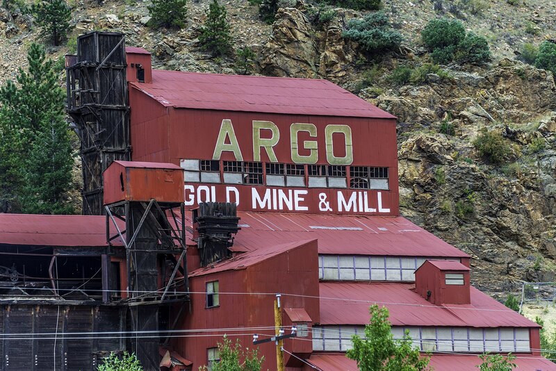
Meanwhile, because of Idaho Springs’ proximity to Interstate 70—convenient for commuting to Denver—the old Argo Mill and Argo Tunnel are visible from the freeway. The tunnel was sealed on January 19, 1943 when an accident flooded the chamber and killed four individuals. In addition to draining water from mines by using a low-grade decline from its origin in Central City to the end point in Idaho Springs, the Argo Tunnel also served to ventilate the mines and provide ore transportation.
In total, the Argo Tunnel processed around three trillion dollars’ worth of gold by today’s standard. Today, visitors can view original mining equipment, the Argo mill itself, and part of the Argo Tunnel. The tunnel is not safe due to the buildup of mining pollution, but removing the pollution is currently part of the EPA superfund site’s goals. Individuals can even experience a glimpse of the lives of Jackson and Gregory as they pan for gold. Overall, the Argo Tunnel serves as a reminder of the environmental damage caused by decades of mining as well as the town histories of Central City, Black Hawk, and Idaho Springs.</p><p><em><strong><a href="https://www.intermountainhistories.org/items/show/487">For more (including 4 images) view the original article</a></strong></em></p>]]></summary>
    <published>2021-09-16T21:20:26+00:00</published>
    <updated>2026-04-17T19:32:10+00:00</updated>
    <link rel="alternate" type="text/html" href="https://www.intermountainhistories.org/items/show/487"/>
    <id>https://www.intermountainhistories.org/items/show/487</id>
    <author>
      <name>Nikki Smith, Brigham Young University</name>
    </author>
  </entry>
  <entry>
    <title type="html"><![CDATA[Oro City: The Beginnings of Leadville]]></title>
    <summary type="html"><![CDATA[<p><strong><em>A once prosperous mining town, Oro City is not just a ghost town left behind by the Colorado gold rush. It is also an environmental hazard.</em></strong></p><img src="https://www.intermountainhistories.org/files/fullsize/128ef543b5fc00e04b72795a7bffb3a1.jpg" alt="Hydraulic mining in California Gulch" /><br/><p><span style="font-weight:400;">In early 1860, prospectors were exploring gulches and panning for gold deep in the Rocky Mountains of Colorado. One prospector, Abe Lee, produced the lucky pan with gold in late April. They named the area California Gulch, supposedly because Abe Lee exclaimed, “I’ve just got California in this here pan!” By summer of the same year, California Gulch’s population had risen from the original party of miners to five thousand individuals, including women. California Gulch was seven miles long and a city grew around it, eventually concentrated toward the northern end of the Gulch. This town came to be known as Oro City and served as the precursor to the modern-day city of Leadville.</span>
<span style="font-weight:400;">Oro City experienced waves of growth and decline as the seasons changed and as gold waned and silver and ore increased. In the beginning, the city had no official government and instead operated using the miners’ code and group meetings.  When Colorado became a territory the next year, Oro City became the county seat of Lake County and elections were held. The city’s population fluctuated seasonally, as winter conditions made mining difficult or impossible. Annual spring thaws repeatedly brought miners back until around 1865. By that point around five million dollars of gold had been extracted from three miles of the gulch, but gold-producing ore was exhausted. The population began to decline thereafter. A stamp mill named “The Printer Boy” was constructed in 1868 and helped partially sustain the local economy, but diminishing ore and continued technological troubles with requisite water pumping hindered business. The Printer Boy soon closed, along with other mills and smelters, and Oro City’s population moved elsewhere.</span>
<span style="font-weight:400;">In 1873 or 1874, a new settlement emerged near Oro City named Slabtown. Slabtown </span><span style="font-weight:400;">later became Leadville when William H. Stevens and Albinus B. Wood began the “Oro Mining Ditch and Fluming Company.” Stevens and Wood bought up large areas in the California Gulch and began producing silver and lead. Mining became concentrated in the Gulch, and the population moved down the mountain.</span>
<span style="font-weight:400;">Today, California Gulch is one of over 200 superfund sites in the state of Colorado, sites the EPA has specifically set aside for environmental recovery. For the most part, the 18 square miles of the superfund site is under control, although young children and expecting mothers should monitor their blood for heavy metals. Although the exposure is under control, the EPA will need to finish construction to seal up mines to create an area that is safe for the public to enter.</span></p><p><em><strong><a href="https://www.intermountainhistories.org/items/show/475">For more (including 3 images) view the original article</a></strong></em></p>]]></summary>
    <published>2021-09-10T23:09:03+00:00</published>
    <updated>2026-04-17T19:32:10+00:00</updated>
    <link rel="alternate" type="text/html" href="https://www.intermountainhistories.org/items/show/475"/>
    <id>https://www.intermountainhistories.org/items/show/475</id>
    <author>
      <name>Nikki Smith, Brigham Young University</name>
    </author>
  </entry>
  <entry>
    <title type="html"><![CDATA[John Mackay, Prince of Miners<br />
]]></title>
    <summary type="html"><![CDATA[<p><strong><em>“No man in Nevada more thoroughly understands the Comstock lode than Mr. Mackay. He has made it his study for years…Mr. Mackay is the “boss” of the big bonanza.” -Dan de Quille (William Wright)</p></strong></p><img src="https://www.intermountainhistories.org/files/fullsize/ed34637a123fbd3b3b813cf0f70aa69a.jpg" alt="John Mackay" /><br/><p>In 1857, the Grosh brothers, Ethan Allen and Hosea came close to making a remarkable discovery in Nevada history. The brothers prospected deposits of gold and silver in the near Six Mile Canon, close to the vein of the famous Comstock Lode. Unfortunately, death came to both brothers before they could continue to explore the area. James Finney and Henry Comstock took the credit a year later, discovering one of the largest silver deposits in America. However, the first years of mining moved slowly. Having bought up large mining claims in Gold Hill and the future Virginia City, a discouraged Comstock made the mistake and sold his interests, hoping to move into the mercantile business. Comstock sold out too early; he ultimately died a poor man in Montana. </p><p>However, others took advantage of the Comstock’s wealth. The lode yielded six large finds, called bonanzas, in the first several years of mining. Beginning with the Ophir bonanza, thousands were flocking to the Virginia City and Gold Hill areas to tap into the massive fortune hidden beneath the earth. Among them was John Mackay. Mackay was born in Dublin, Ireland and emigrated to America in 1840 as a young boy. Tragedy struck the family two years after their arrival to the States when Mackay’s father died unexpectedly. At a young age Mackay left school to work, needing to support his mother and sister. Perhaps for this reason, Mackay headed west to the gold fields in California in 1851. Like many miners during the time, Mackay worked in the mines, but did not strike it rich. He eventually arrived in Virginia City in 1859 practically penniless, looking for the opportunity that California had not offered him. Family was his main motivation in striking it rich. Telling his friend Jack O’Brien, “All I want is my $30,000; with that I can make my old mother comfortable.” Little did Mackay know that in the next two decades he would not only receive his $30,000, but would be averaging $300,000 a month. </p><p>Mackay started at $4 a day as a placer miner, but quickly worked his way up and become a superintendent in the Caledonia Tunnel Mining Company. With enough money saved, Mackay began investing in several mining companies. This business move changed his career, leading him to a road of riches. Buying up stock alongside James Flood, William S. O’Brien, James Fair, these men soon owned half of the mining shares in Virginia City. The four would be known as the “Bonanza Kings” of the Comstock. Mackay was determined to make it big in Virginia City. While most men in his position preferred the comforts of overseeing in an office space, Mackay frequented the deep mining shafts alongside his men. He offered fair and generous wages to his workers, but also worked them hard. He dug deeper into the lode, gambling on the hope that there was more ore to be discovered. His determination paid off, as his company hit the “big bonanza.” The find yielded $166 million between 1873 to 1878. Mackay became one of the richest men in the world. He offered a life of luxury to his family. He donated to charities, showed patronage to the arts, met foreign figureheads, and traveled the world. Mining finally slowed in the 1880’s, but the legacy of the Comstock lived on in the pockets of men like John Mackay and the Bonanza kings. </p><p><em><strong><a href="https://www.intermountainhistories.org/items/show/245">For more (including 3 images) view the original article</a></strong></em></p>]]></summary>
    <published>2019-01-12T00:50:31+00:00</published>
    <updated>2026-04-17T19:32:03+00:00</updated>
    <link rel="alternate" type="text/html" href="https://www.intermountainhistories.org/items/show/245"/>
    <id>https://www.intermountainhistories.org/items/show/245</id>
    <author>
      <name>Rachel Hendrickson, Brigham Young University</name>
    </author>
  </entry>
</feed>