<?xml version="1.0" encoding="UTF-8"?>
<feed xmlns="http://www.w3.org/2005/Atom">
  <title type="text">Intermountain Histories</title>
  <updated>2026-04-17T19:32:21+00:00</updated>
  <generator uri="http://framework.zend.com" version="1.12.20">Zend_Feed_Writer</generator>
  <link rel="alternate" type="text/html" href="https://www.intermountainhistories.org/"/>
  <link rel="self" type="application/atom+xml" href="https://www.intermountainhistories.org/items/browse?output=rss2"/>
  <id>https://www.intermountainhistories.org/</id>
  <author>
    <name>Intermountain Histories</name>
    <uri>https://www.intermountainhistories.org</uri>
  </author>
  <link rel="hub" href="https://pubsubhubbub.appspot.com/"/>
  <entry>
    <title type="html"><![CDATA[Fort Bridger and the Donner Party]]></title>
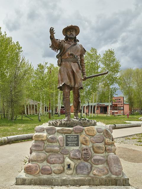
    <summary type="html"><![CDATA[<p><strong><em>On July 20th, 1846, a group of families on an emigrant train in present-day Wyoming separated from the main party to take a supposed shortcut that would expedite their journey to the Mexican territory of Alta California. This group known as the Donner Party started their journey on the cutoff with the goal of reaching Fort Bridger, which would be the point of no return on their ill-fated journey. </em></strong></p><img src="https://www.intermountainhistories.org/files/fullsize/e6c5db8e3d5e018d3b0a52d9335af3ff.jpg" alt="Statue of Jim Bridger at the Fort Bridger Historic Site" /><br/><p>Mountain men and adventurers Jim Bridger and Louis Vasquez established this fort in modern-day southwest Wyoming in 1842. Originally built as a trading post to service and profit off the rush of the trappers heading West, it found purpose as a resupply point for emigrant parties heading to California. While the word “fort” brings to mind high stone walls, a California-bound party led by Edwin Bryant in early 1846 described Fort Bridger as <i>“two or three miserable log cabins, rudely constructed, and bearing but a faint resemblance to habitable houses.”</i> The Donner Party reached Fort Bridger on July 27th, 1846. Earlier on the trail, the party had received letters from Lansford Hastings, the author of the cutoff. He advertised it as an alternative and shorter route, and said that if they met him at Fort Bridger, he would guide them through it. Despite James Clyman’s warnings of the cutoff to James Reed, a father of 6 and leader of the party, the allure of time and distance saved proved seductive. According to survivor reports, James Reed believed that the route would save them <i>“350 or 400 miles” </i>and relayed that Bridger had described it as ”<i>a fine, level road with plenty of water and grass.”</i> It is theorized that Bridger, a seasoned mountain man, knew of the danger of the cutoff but goaded them on regardless to increase emigrant traffic through his fort. After repairs, restocking, and rest, the Donner party left Fort Bridger on July 31st. Growing from around 60 members to 74 because of the addition of the McCutchen family and several teamsters. They proceeded towards the Wasatch Mountains in modern-day Utah. Emigrant parties continued to utilize Fort Bridger for the following decade, but the Donner party remains one of the most influential to do so. The fort remained operational until Bridger's run-ins with the law caught up to him, including an arrest warrant issued from Salt Lake City, Utah for <i>“furnishing the Indians with powder and lead to kill Mormons.”</i> The fort was sold to the Church of Jesus Christ of Latter-Day Saints (or Mormons) in 1855, with the church having documents of its sale from Vasquez representing both him and Bridger. The Saints held onto this fort until November of 1857. President James Buchanan sent an army commanded by General Albert S. Johnston to suppress a supposed Mormon rebellion. In preparation the saints burned several buildings before retreating to Echo Pass in Utah. Following its abandonment by the Saints, the fort was seized by the United States military, where it saw its commanders switch hands for decades. It found use as a staging area for military exercises against Native Americans and general military travel during the mid 19th century. As the years passed, the land under Fort Bridger’s jurisdiction became smaller as the threat of attacks from Native Americans subsided. It was abandoned on October 1st, 1890. This trading post, fort, and military depot served as a landmark for Western history as emigrants, natives, and mountain men all crossed its path. For the Donners, it served as their final resupply point, and for many the last semblance of civilization they would ever see. For the next 760 miles, the Donners would travel through rough mountain passes and barren salt deserts with minimal rest and resupply. The ill-intentioned words of Hastings and Bridger would prove to be a death sentence.</p><p><em><strong><a href="https://www.intermountainhistories.org/items/show/940">For more (including 6 images) view the original article</a></strong></em></p>]]></summary>
    <published>2026-02-02T17:23:00+00:00</published>
    <updated>2026-04-17T19:32:21+00:00</updated>
    <link rel="alternate" type="text/html" href="https://www.intermountainhistories.org/items/show/940"/>
    <id>https://www.intermountainhistories.org/items/show/940</id>
    <author>
      <name>Samuel Watson, Brigham Young University</name>
    </author>
  </entry>
  <entry>
    <title type="html"><![CDATA[Hastings Cutoff: A Not-So-Short Cut]]></title>
    <summary type="html"><![CDATA[<p><strong><em><span style="font-weight:400;">Made famous by the disaster of the Donner-Reed Party in 1846, Hastings Cutoff saved travelers a few hundred miles on the trek to Oregon or California. The trail started at Fort Bridger in present-day Wyoming and traversed the Wasatch Mountains before reaching the Salt Flats. However, it proved to be very unsuitable – even disastrous – for wagon travel.</span></em></strong></p><img src="https://www.intermountainhistories.org/files/fullsize/49e805c728cb5ee3cd9c072ba1c37956.jpg" alt="Fort Bridger, established in 1843. " /><br/><p><span style="font-weight:400;">Despite its name, the western explorer John C. Frémont was the first to traverse the trail that came to be known as Hastings Cutoff. The route was named after Lansford Warren Hastings in the following summer of 1846 when Hastings made it famous in his </span><i><span style="font-weight:400;">Emigrants’ Guide to Oregon and California</span></i><span style="font-weight:400;">, encouraging those headed westward to take it and save three hundred miles. He also promised that he would meet emigrants at Fort Bridger and guide them the rest of the way. That promise further convinced the Donner brothers and James Reed of the wisdom of taking the cutoff, though several in the party decided to stick with the proven trail.</span>
<span style="font-weight:400;">Unfortunately, Hastings had already left Fort Bridger to guide emigrants already on the trail by the time the Donner-Reed Party arrived at the fort. He promised to leave letters with directions for them. Edwin Bryant, a fellow expeditioner, advised in a letter to Reed that the plans to take the cutoff be abandoned. There was a forty-mile stretch devoid of water and the trail was simply not fit for wagons. Jim Bridger and Louis Vasquez withheld Bryant’s letter, however, since they had a financial interest in seeing Hastings Cutoff traveled. Partly because they did not receive that letter, the Donner-Reed Party pressed on. </span>
<span style="font-weight:400;">Almost nothing that the Donner-Reed Party understood about the cutoff was accurate, from the easiness of the way to the length of the trail and the available supplies of water and provisions. In her diary, Virginia Reed Murphy recorded that “at times it was hard to find any trace of the cutoff.” </span>
<span style="font-weight:400;">Hastings left extremely vague directions along the way and refused to guide the Donner-Reed Party when Reed, C. T. Stanton, and William Pike went and asked for his help. It was too dangerous to continue through Weber Canyon, so they took their chances in uncharted territory, where there were no roads or clear paths through the trees and underbrush. Virginia noted that “It took the men six days to clear a trail only thirteen miles in length.” They finally got through the Wasatch Mountains and by the time they reached the Great Salt Lake, the cutoff had taken a month (as opposed to the promised week) “and our cattle were so exhausted that they were not fit to cross the desert.” </span>
<span style="font-weight:400;">It truly is no wonder that once Virginia was settled in California, she wrote the following to friends back in the East who were planning to travel West: “Bring nothing but provisions and just enough clothing to last until you get here…and don’t take any cutoffs.” </span>
<span style="font-weight:400;">Much of the scholarship about Hastings Cutoff is about Hastings himself, if he were just as much a victim of the hard trail as the others or a scheming charlatan. Most people choose to believe the latter, especially as he received several death threats for his advice.</span></p><p><em><strong><a href="https://www.intermountainhistories.org/items/show/880">For more (including 4 images) view the original article</a></strong></em></p>]]></summary>
    <published>2025-01-27T04:23:30+00:00</published>
    <updated>2026-04-17T19:32:20+00:00</updated>
    <link rel="alternate" type="text/html" href="https://www.intermountainhistories.org/items/show/880"/>
    <id>https://www.intermountainhistories.org/items/show/880</id>
    <author>
      <name>Danielle Morgan, Brigham Young University</name>
    </author>
  </entry>
  <entry>
    <title type="html"><![CDATA[Creation of Wind River Reservation<br />
]]></title>
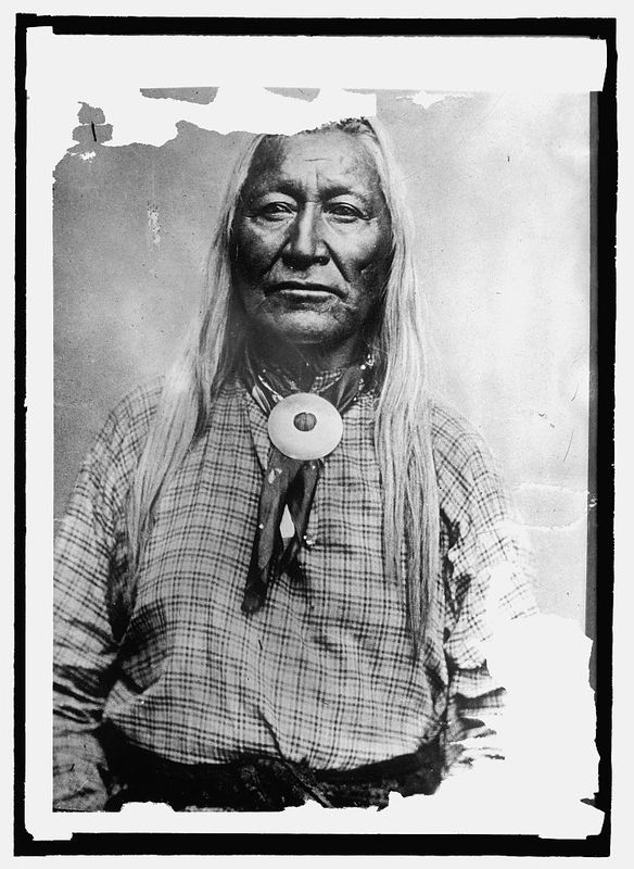
    <summary type="html"><![CDATA[<p><strong><em>“The Wind River Valley which is the favorite hunting ground for these Indians, will be the most suitable locality…” -Luther Mann Jr., Indian Agent over the Fort Bridger Indian Agency</p></strong></p><img src="https://www.intermountainhistories.org/files/fullsize/0534f93f1289fd0db2228344bf3947e0.jpg" alt="Washakie" /><br/><p>The Eastern Shoshone tribe occupied the region north of Utah and around Fort Bridger. After Mormon pioneers began settling the area around Bear River, Shoshone Chief, Washakie, and his band of Eastern Shoshone were forced to leave the region. Washakie was known for his peacekeeping. Federal officials favored him because he tried to keep peace between his tribe and white settlers. While Washakie was successful in keeping relative peace between his people and the setters moving into Shoshone territory, he still fought for his people. After signing the Fort Bridger Treaty of 1863, Washakie determined that his people needed a permanent place to settle.  </p><p>Looking for an area to set aside as a reservation, the Wind River Valley in western Wyoming was at the top of the list. Indian Agent, Luther Mann, was the first to recommend the area for a possible reservation. He said that it was “one of the finest valleys in the mountains.” The Eastern Shoshone used the region as their winter hunting grounds because of the large herds of buffalo. However, it took nearly a decade for a reservation to be set aside. One superintendent over Indian Affairs mentioned in his reports that “the Wind River Valley which is the favorite hunting ground for these Indians, will be the most suitable locality, unless it shall be found to be rich in mines of gold and silver and springs of petroleum.” Unfortunately, Indian affairs did not take precedence over a higher federal agenda. Establishing peace with the Native Americans was important, but it did not trump the possibility of gold.  </p><p>However, the reservation was finally established by treaty in the Fort Bridger Treaty of 1868. Although Washakie and the Indian agency had been campaigning for a reservation for years, the reservation was organized as a protection for the white settlers. The Indian wars on the plains were coming further west, which concerned many white settlements. Incidents on the Bozeman trail and raids on mining communities left white settlers fearful. Seeing an opportunity to protect the settlements, the reservation was created as buffer between the warring tribes and the white settlements.  The Eastern Shoshone have maintained the reservation since 1868. Washakie continued to lead his people from the reservation. </p><p><em><strong><a href="https://www.intermountainhistories.org/items/show/244">For more (including 3 images) view the original article</a></strong></em></p>]]></summary>
    <published>2019-01-12T00:20:57+00:00</published>
    <updated>2026-04-17T19:32:03+00:00</updated>
    <link rel="alternate" type="text/html" href="https://www.intermountainhistories.org/items/show/244"/>
    <id>https://www.intermountainhistories.org/items/show/244</id>
    <author>
      <name>Rachel Hendrickson, Brigham Young University</name>
    </author>
  </entry>
  <entry>
    <title type="html"><![CDATA[Fort Bridger the Crossroads of the West]]></title>
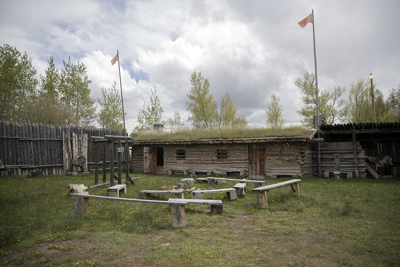
    <summary type="html"><![CDATA[<p><strong><em>“‘Fort Bridger’, as it is called, is a small trading-post, established and now occupied by Messrs. Bridger and Vasquez. The buildings are two or three miserable log-cabins, rudely constructed, and bearing but a faint resemblance to habitable houses.” – Edwin Bryant, American frontiersman and guide along the Overland trail</p></strong></p><img src="https://www.intermountainhistories.org/files/fullsize/4dbe8c195526e7485744bea72f784b0d.jpg" alt="Inside Stockade at Fort Bridger" /><br/><p>Located just off I-80, thirty miles from Evanston, Wyoming, lies the historic site of Fort Bridger. Fort Bridger has a long history of being involved with the American fur trade, western overland migration, and military involvement against the Mormons and Native Americans. It sits on the historic crossroads of the Oregon/California trail and the Mormon trail, and later the Pony Express Route, the Transcontinental Railroad, and the Lincoln Highway.</p><p>Fort Bridger was built by Jim Bridger in 1843. Bridger was a mountain man and frontiersman and heavily involved during the rendezvous fur trade period. He built his trading post close to popular rendezvous areas, as well as near the Oregon/California trail, hoping to gain business from the early emigrants heading towards Oregon and California. The original fort comprised of two log houses, about 40 feet long, with a corral for livestock. The fort also had a blacksmith shop, which was valuable for emigrants on the trail. While it was not as luxurious as Fort Laramie, Fort Bridger was still a welcome sight for travelers used to wandering in the wilderness. </p><p>In 1847, the first of the Mormon pioneers passed through the area. Jim Bridger and the Mormons initially maintained a good relationship, but quickly dissipated when the Mormons, feeling that the prices were too inflated at the fort, built their own fort nearby. After a series of raids on the fort, Bridger and his business partner, Louis Vasquez, abandoned the fort and the Mormons moved in. Eventually Bridger sold the fort to the Mormons, although he later disputes that claim. Adding additional fortifications to the fort, such as stone walls, the Mormons continued to use the fort as a supply station for emigrants heading west. However, in 1857, the Mormons abandoned and burned the fort down when rumors that federal troops were marching towards Salt Lake City with orders to bring Brigham Young in line. The US army subsequently occupied the area, deeming it a good proximity for a military presence over the Mormons. </p><p>The 1859 military reservation boundaries stretched 20 miles east to west, and 25 miles north to south, creating a buffer between the fort and the Mormon settlements. The army rebuilt the stone structures, and added a large parade ground, barracks, and supply buildings. Like most military forts in the west, Fort Bridger did not have walls that surrounded the entire fort, instead, the buildings faced inward towards each other with the open parade grounds serving as the center of the fort. The US army operated the fort from 1857 to 1890, dealing with disputes between the Mormons and the local Native American tribes. In the early 1860’s, Fort Bridger became the home to the Fort Bridger Indian Agency, which served the Eastern Shoshone, and parts of the mixed Bannock and Shoshone tribes. After the end of the Indian Wars in 1890, the military officially closed and abandoned the fort. Jim Bridger’s dream of a trading post became much more; Fort Bridger became the crossroad in the west, bridging the gap between the east and the west, political disputes, and white settlers and Native Americans. </p><p><em><strong><a href="https://www.intermountainhistories.org/items/show/243">For more (including 5 images) view the original article</a></strong></em></p>]]></summary>
    <published>2019-01-11T23:43:53+00:00</published>
    <updated>2026-04-17T19:32:03+00:00</updated>
    <link rel="alternate" type="text/html" href="https://www.intermountainhistories.org/items/show/243"/>
    <id>https://www.intermountainhistories.org/items/show/243</id>
    <author>
      <name>Rachel Hendrickson, Brigham Young University </name>
    </author>
  </entry>
  <entry>
    <title type="html"><![CDATA[Making Peace with the Eastern Shoshone <br />
]]></title>
    <summary type="html"><![CDATA[<p><strong><em>“Friendly and amicable relations are hereby re-established between the bands of the Shoshone nation, parties hereto, and the United States; and it is declared that a firm and perpetual peace shall be henceforth maintained between the Shoshone nation and the United States.” -Article I, Treaty of Fort Bridger 1863</em></strong></p><img src="https://www.intermountainhistories.org/files/fullsize/0f9f1f3010409997a655f2e86c01686e.jpg" alt="Fort Bridger depicting Indians and Soldiers" /><br/><p>By 1862, the relationship between settlers and the Shoshone and Bannock tribes had deteriorated. According to Indian Agent Luther Mann’s report in 1862, “Large numbers of the Shoshones, in conjunction with the Bannocks, who range along the southern boundary of Washington Territory, have been committing upon the emigrants travelling to California and Washington some of the most brutal murders ever perpetrated upon this continent.” Federal officials felt that this violence was due to the lack of game left in the territory. The increasing number of white settlers in the region began to encroach on the Indians hunting grounds. Mann concluded that, “There is very little game in this Territory, by which the Indians are enabled to procure the necessary means of subsistence… Owing to the limited amount of means placed in my hands, I have been unable, as fully as I should have desired, to supply their wants, thereby preventing them from supplying themselves by unlawful means.” </p><p>However, while tensions were rising with the mixed bands of Bannock and Shoshone, the Eastern Shoshone tribe remained above violence. Mann’s opinion says that, “I am glad to say, however, that Washakee, the head chief of the Shoshones, and his band, have abstained from any acts of violence or theft, which have characterized a large portion of the tribe... I am apprehensive that a general outbreak of hostilities will take place throughout this entire region of country.” The Eastern Shoshone were more concerned about getting enough supplies to last them through the winter. Mann wrote that he found the tribes in “very destitute condition,” and Superintendent James Doty requested that the Indian Commissioner provide more funds for supplies, hoping to prevent the Indians from “committing depredations and interfering with the transportation of the mail.” Hence, the necessity of a treaty was needed.</p><p>On July 2, 1863, the Eastern Shoshone tribe signed a treaty with US federal officials. Washakie, the most famous Shoshone leader was among the ten bands of Eastern Shoshone represented in the treaty. The treaty stipulated peace between the Eastern Shoshone and US government. First it established that the overland mail trails, telegraph lines, and railroad tracks that ran through Shoshone territory were under the protection of the United States. It also established the boundaries of the Shoshone territory and provided annuities for the Shoshone people. The treaty stipulated that the US government would compensate the Shoshone tribe $10,000 annually in supplies for a twenty year period for the loss of game on their land. Additionally, the Shoshone would receive an immediate payment of $6000 in clothing and provisions for the upcoming winter. The treaty officially signaled peace between the Eastern Shoshone and the federal government. However, while the treaty was a step in bringing peace for the Shoshone it did not establish a reservation. It would take a later treaty to give an official reservation for the Eastern Shoshone people. </p><p><em><strong><a href="https://www.intermountainhistories.org/items/show/242">For more (including 3 images) view the original article</a></strong></em></p>]]></summary>
    <published>2019-01-11T22:57:50+00:00</published>
    <updated>2026-04-17T19:32:03+00:00</updated>
    <link rel="alternate" type="text/html" href="https://www.intermountainhistories.org/items/show/242"/>
    <id>https://www.intermountainhistories.org/items/show/242</id>
    <author>
      <name>Rachel Hendrickson, Brigham Young University</name>
    </author>
  </entry>
  <entry>
    <title type="html"><![CDATA[The Fort Bridger Indian Agency]]></title>
    <summary type="html"><![CDATA[<p><strong><em>Before the creation of official reservations for Native American tribes, the federal government organized Indian agencies across the nation to supervise tribal activities. The Fort Bridger Indian Agency was organized in 1861 to supervise the Shoshone and Bannock tribes.  </em></strong></p><img src="https://www.intermountainhistories.org/files/fullsize/2e35431dabbc2924fcec9dadfacfacc8.jpg" alt="Fort Bridger" /><br/><p>In 1861, the Eastern Shoshone Native American tribes and mixed bands of Shoshone and Bannock tribes were combined into a new agency, the Fort Bridger Indian Agency. Previously, federal agents supervised these tribes from Salt Lake City, but due to the increased tension between the settlers and tribes, a new agency was organized. For two years, the agency attempted to maintain peace between the settlers and Bannocks through various means, including appeasement packages and the call for federal enforcement. It all escalated in violence, with the battle between some Shoshone tribes and Colonel Patrick Connor’s men at Bear River, Idaho. As a result, 1863 was marked as a year of treaty-making among the various Shoshone and Bannock tribes.  After the signing of the treaties, there was relative peace at the Fort Bridger Indian agency for several years. Many of the treaties stipulated that annual annuities were to be delivered to Fort Bridger. Upon delivery, Indian agent Luther Mann distributed the supplies to the tribes before they left for their winter hunting grounds. </p><p>However, the Indian Agency often ran into problems. One problem was distributing annuities. Between 1863-1868 the federal government was faithful in sending supplies annually. However, they were sometimes guilty of either not sending the full amount or sending the supplies late. This caused some frustration with the Indian agents and the Shoshones. Indian Agent Luther Mann recognized the need for these supplies to arrive in time before the Shoshone’s annual move to their winter hunting grounds. He petitioned, “that in the future all supplies designed for this agency should be forwarded as early as practicable, that they might reach their destination by the first of August every year. It would thus give the agent time to collect the Indians, who from necessity are scattered over a very large extend of country, distribute their presents, and send them to their hunting-grounds early.” </p><p>However, Mann’s request was not always granted. Additionally, with the discovery of gold and silver in and near the territory, more white settlers flooded the region. These settlers often crossed into designated hunting grounds, causing distress among the natives. To avoid potential violence, Mann occasionally stepped in and served as a mediator between the settlers and the natives, especially among the Bannock tribes. The Indian Agency continued to operate out of Fort Bridger until the Fort Bridger Treaty of 1868. As the treaty stipulated an Indian reservation was created, the Wind River Reservation, for the Eastern Shoshone tribe. The Fort Bridger Indian Agency was officially dissolved in 1871, and while their relationship started off rough, members from both the Eastern Shoshone tribe and the agency contributed in establishing peace between one another. </p><p><em><strong><a href="https://www.intermountainhistories.org/items/show/241">For more (including 3 images) view the original article</a></strong></em></p>]]></summary>
    <published>2019-01-08T20:40:38+00:00</published>
    <updated>2026-04-17T19:32:03+00:00</updated>
    <link rel="alternate" type="text/html" href="https://www.intermountainhistories.org/items/show/241"/>
    <id>https://www.intermountainhistories.org/items/show/241</id>
    <author>
      <name>Rachel Hendrickson, Brigham Young University</name>
    </author>
  </entry>
</feed>