<?xml version="1.0" encoding="UTF-8"?>
<feed xmlns="http://www.w3.org/2005/Atom">
  <title type="text">Intermountain Histories</title>
  <updated>2026-04-17T19:32:17+00:00</updated>
  <generator uri="http://framework.zend.com" version="1.12.20">Zend_Feed_Writer</generator>
  <link rel="alternate" type="text/html" href="https://www.intermountainhistories.org/"/>
  <link rel="self" type="application/atom+xml" href="https://www.intermountainhistories.org/items/browse?output=rss2"/>
  <id>https://www.intermountainhistories.org/</id>
  <author>
    <name>Intermountain Histories</name>
    <uri>https://www.intermountainhistories.org</uri>
  </author>
  <link rel="hub" href="https://pubsubhubbub.appspot.com/"/>
  <entry>
    <title type="html"><![CDATA[Apache County on Route 66]]></title>
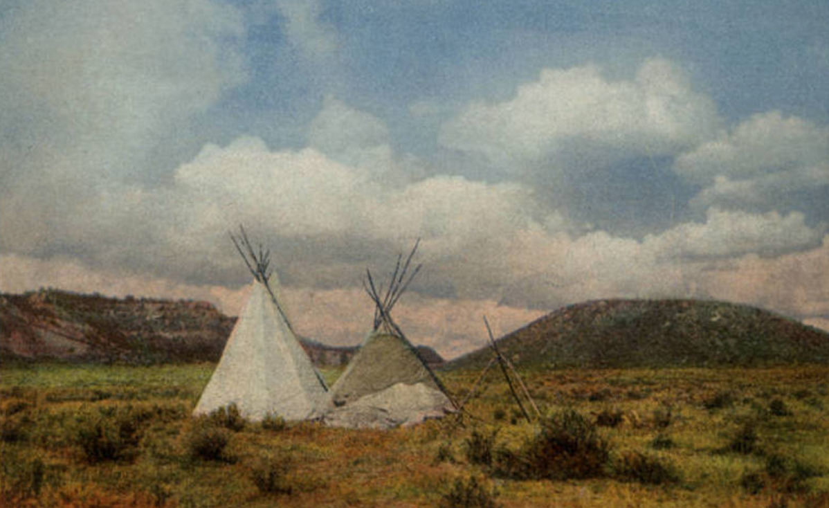
    <summary type="html"><![CDATA[<p><strong><em><span style="font-weight:400;">The land on the Arizona-New Mexico border has a storied past–from Spanish trading routes and gutsy American cowboys to railroad tracks and the boom of a brand-new highway.</span></em></strong></p><img src="https://www.intermountainhistories.org/files/fullsize/c94d71a364203dd0571092e6433d1afa.jpg" alt="In Apache Land, Arizona" /><br/><p><span style="font-weight:400;">Apache County, which makes up the northeast region of Arizona, has been occupied since at least 800 A.D. by Ancestral Puebloans (formerly known as “Anasazi”). The first of many Spanish expeditions to the Arizona/New Mexico region lasted from 1540-1542, and began a tumultuous relationship with the indigenous population. In the following years Spanish colonists introduced new cattle to the region, and sheepherding became a popular practice for the next several hundred years. In 1864 the U.S. government issued a forced displacement of the Navajo people known as the “Long Walk.” It was a harsh and unforgiving journey that resulted in at least 500 deaths. One region exiled during the Long Walk later became known as Lupton, one of several unincorporated communities along Route 66. </span>
<span style="font-weight:400;">Famous for its scenic “painted cliffs,” brightly colored roadside shops, and appearance in the 1940 film adaptation of </span><i><span style="font-weight:400;">Grapes of Wrath</span></i><span style="font-weight:400;">, Lupton was built from a railroad settlement in 1905. The community's namesake, G.W. Lupton, was a trainmaster and owner of the first trading post in the area. In the post-war tourism boom of the early 1950s, the Yellowhorse family of the Navajo Reservation opened their own trading post. The building was painted a striking yellow with red and black painted signage advertising “The Indian Market Place: Deal with the Friendly Navajo.” Although Route 66 had given the area a new life after the railroad revolution, the construction plans for Interstate 40 bypassed Lupton. Like so many other little towns that survived only from the tourist revenue, Lupton soon slipped into obscurity. The shop fronts have not been well-preserved, and there is not much charm left to draw people in, but the sight of the painted cliffs when the sun hits them just right remains as breathtaking as it always was.</span>
<span style="font-weight:400;">Twelve miles west of Lupton and the New Mexico border another now deserted town called Houck has its own storied past. In 1877 James Houck, a horseback-riding mail carrier, established a trading post along his route which ran from Prescott, Arizona to Fort Wingate, New Mexico. The post, which was called “Houck’s Tank,” expanded into a small community which adopted Houck’s name. He lived a fairly successful life, but had a hard time staying out of trouble. He was no stranger to shoot-outs or plots of revenge–and his friendship with the Tewksbury family put him in the middle of a major feud between two ranching families. Known as the Pleasant Valley War or the Graham-Tewksbury Feud, it resulted in somewhere between thirty-five to fifty deaths. His career beyond mail delivery included sheepherding, mining, trading, and a position as the Apache County Deputy Sheriff. Yet he is memorialized now as the namesake for the once lively ghost town of Houck, Arizona.</span>
<span style="font-weight:400;">In late 1926, Route 66 made its way through Houck, attracting new visitors to what had once been nothing more than a trading post. Although becoming a part of Route 66 helped bring a more steady flow of business and traffic, Houck never quite blossomed the way other towns along the highway did. A gas station, a grocery store, a “Pancake House,” and a few other small establishments popped up, but much of it has since gone out of business and become overgrown. In 1998, long after the excitement died down, the Native American Bahá'í Institute opened as a place of worship, training, and gathering place for the Navajo reservation and surrounding communities. </span></p><p><em><strong><a href="https://www.intermountainhistories.org/items/show/800">For more (including 5 images) view the original article</a></strong></em></p>]]></summary>
    <published>2024-05-15T20:15:34+00:00</published>
    <updated>2026-04-17T19:32:17+00:00</updated>
    <link rel="alternate" type="text/html" href="https://www.intermountainhistories.org/items/show/800"/>
    <id>https://www.intermountainhistories.org/items/show/800</id>
    <author>
      <name>Megan Bailey, Brigham Young University</name>
    </author>
  </entry>
  <entry>
    <title type="html"><![CDATA[Fort Verde State Park and General Crook]]></title>
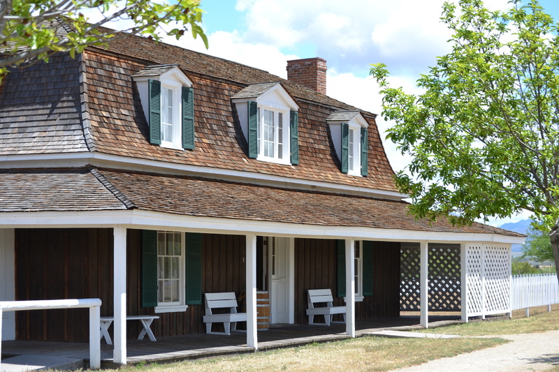
    <summary type="html"><![CDATA[<p><strong><em>Brigadier General George R. Crook (September 8, 1828 -March 21, 1890) is popularly recognized as the quintessential 'Indian Fighter' of the late nineteenth century, despite the fact that he sometimes expressed anger not at the native peoples but toward the interfering white settlers. In 1871 Crook's forces deployed from Fort Verde in the northern Arizona Territory in pursuit of the Tonto Apache.</em></strong></p><img src="https://www.intermountainhistories.org/files/fullsize/6c733c5983f11c9a8df63d66a11a7fcc.jpg" alt="Married Officers&#039; Quarters" /><br/><p>General George R. Crook used Fort Verde in northern Arizona Territory as his primary base of operations for the unenviable task of relocating Apache tribes in the Arizona territory onto reservations. Located at the confluence of the East Fork of Beaver Creek and the 'Rio' Verde River, at the base of the Colorado Plateau, Fort Verde housed officers, doctors, enlisted men, families, and scouts. Many of the officers' wives enjoyed their time at the fort because of its many modern amenities including, bath tubs, silver ware, and draperies. Martha Summerhayes (wife of Lt. John Summehayes) recounted that she felt as though they had finally reached “civilization” when arriving at Fort Verde. </p><p>Crook's objective at Ft. Verde was to provide protection to the early settlers, the Butterfield Stage, and to facilitate the removal of all Indians from both Verde Valley and the Tonto Basin to the east. Crook appreciated the necessity of recruiting scouts. Captain John G. Bourke remembered, “There were Navajoes(sic), Apaches, Yaquis, Mexicans, and half-breeds of any tribe one could name.” Among the most celebrated scouts were Alchesay, and Chiquito, both of whom received the Medal of Honor for their actions against the Tonto Apache. Crook also admired how   “Our Indian allies would crawl upon their hands and knees for long distances.” in pursuit of renegades.  Crook especially appreciated this dedication given the challenge of the rugged Tonto terrain north of the fort, “There is hardly a space of ten miles square, that has not some lava bed, precipitous canyons, or caves with which the Indians can hold out.” After three years of driving the Tonto Apache from their rugged homeland, the Army force marched the survivors 180 miles to the reservation at San Carlos. The War Department  also required the peaceful Yavapai people to join their Apache neighbors on the journey referred to as the 'Exodus'.    </p><p>Ironically, one of the greatest challenges for the Army was protecting the Indians from the homesteaders. In a letter to General Philip H. Sheridan, Crook described, “There are large flocks of human vultures wrangling over the patronage to be bestowed, and who in greed do not hesitate at any deed; the complications arising can be imagined.” The most egregious incident resulted in the death of a young cavalry officer in a conflict with local settlers.  Lieutenant Jacob Arny lost his life, defending the Indians from the settlers.  Despite Crook's request for punishment, the courts never prosecuted the locals responsible for the deed.  </p><p>The State of Arizona established Fort Verde State Park in 1972, in recognition of it being the finest, preserved military facility of the Indian Wars in the state. The Park features the former administrative building, the doctor's quarters, the officer's quarters, the married officer's quarters, and a significant collection of military artifacts.</p><p><em><strong><a href="https://www.intermountainhistories.org/items/show/337">For more (including 4 images) view the original article</a></strong></em></p>]]></summary>
    <published>2019-09-18T03:58:22+00:00</published>
    <updated>2026-04-17T19:32:06+00:00</updated>
    <link rel="alternate" type="text/html" href="https://www.intermountainhistories.org/items/show/337"/>
    <id>https://www.intermountainhistories.org/items/show/337</id>
    <author>
      <name>Robert M. Estrada, Northern Arizona University</name>
    </author>
  </entry>
  <entry>
    <title type="html"><![CDATA[Forest Service Road 300 and General Crook]]></title>
    <summary type="html"><![CDATA[<p><strong><em>Brigadier General George R. Crook (September 8, 1828 -March 21, 1890)  is popularly recognized as the quintessential 'Indian Fighter' of the late nineteenth century. In the Apache Campaign, Crook's troopers frequented the Mogollon Rim above Fort Verde in central Arizona Territory on the path to engage the Tonto Apache. This crest trail is designated as Forest Service Road 300.</em></strong></p><img src="https://www.intermountainhistories.org/files/fullsize/d160b0efcada34d1ed16a5a3c1f4d869.jpg" alt="General Crook and William Alchesay" /><br/><p>Located at the crest of the Mogollon Rim, the trail that became Forest Service Road 300 (FS 300) served as the primary path for engagements against the Tonto Apache. FS 300 traverses the 2,000 feet above the Verde Valley on the Colorado Plateau. There are several historical landmarks along the route, such as the '13 mile rock', military telegraph lines, and the grave of Andres Moreno of 'E' Company. Thirteen miles from Fort Verde, near the ridge of the Colorado Plateau, is an original rock carving, marking the troopers' ascent from the Verde Valley. A quarter of a mile onto FS 300, there are white insulators scattered in the forest, from the original nineteenth century telegraph lines. One mile from Hwy 87 is the grave of Andres Moreno who served in the 1st Arizona Infantry, under the command of Lieutenant Primitivo Cervantes in 1865. In 1887, teamster Knox Lee murdered Moreno. Lee plead guilty for manslaughter and was sentenced to seven years. </p><p>In 1871, Crook used this route as he began the unenviable mission of  attempting to separate native Apache on the Colorado Plateau from white settlers in the Verde Valley. According to Lt. John G. Bourke, “Our line of travel was due east--at the base of the great Mogollon range to Camp Verde.” General Crook was usually the first man to 'saddle-up' each morning onto his mule 'Apache'.                                                                                    </p><p>In April that year, following raids on early homesteaders, Crook's men routed a band of over twenty Tonto Apache.  The after action report recorded thirty one “Indians killed”, no wounded, and two captured. Apache oral history states that the incident was a “massacre” by the Army.  The lack of any 'wounded Indians,' along with no record of the commanding officer, leads to suspicion over the circumstances of the engagement.  Crook recorded, “One of the difficulties in managing such Indians is that you must delegate your powers and depend upon others to execute. There are questions constantly arising which require prompt action, even if the most summary punishment should be melted out to them.” Unfortunately, General Crook's legitimate concerns over junior officers implementing his concerns over restraint, landed on General Sheridan's desk, who supported the “extermination” of the Indians. In August 1871, the Apache's retribution may have resulted in the killing of farmer Joseph Burroughs, a homesteader in the 'Rio Verde.'                                                                                                     	 </p><p>In 1875, General Crook departed the Department of Arizona to report to the Department of the Platte. Many of  his concerns with the Apache remained unresolved, but his route became FS 300,  a well- established supply route to the Colorado Plateau and the White Mountains.  </p><p><em><strong><a href="https://www.intermountainhistories.org/items/show/331">For more (including 5 images) view the original article</a></strong></em></p>]]></summary>
    <published>2019-09-13T06:45:32+00:00</published>
    <updated>2026-04-17T19:32:06+00:00</updated>
    <link rel="alternate" type="text/html" href="https://www.intermountainhistories.org/items/show/331"/>
    <id>https://www.intermountainhistories.org/items/show/331</id>
    <author>
      <name>Robert M. Estrada, Northern Arizona University</name>
    </author>
  </entry>
</feed>