<?xml version="1.0" encoding="UTF-8"?>
<feed xmlns="http://www.w3.org/2005/Atom">
  <title type="text">Intermountain Histories</title>
  <updated>2026-04-17T19:32:05+00:00</updated>
  <generator uri="http://framework.zend.com" version="1.12.20">Zend_Feed_Writer</generator>
  <link rel="alternate" type="text/html" href="https://www.intermountainhistories.org/"/>
  <link rel="self" type="application/atom+xml" href="https://www.intermountainhistories.org/items/browse?output=rss2"/>
  <id>https://www.intermountainhistories.org/</id>
  <author>
    <name>Intermountain Histories</name>
    <uri>https://www.intermountainhistories.org</uri>
  </author>
  <link rel="hub" href="https://pubsubhubbub.appspot.com/"/>
  <entry>
    <title type="html"><![CDATA[Brigham Young Academy]]></title>
    <summary type="html"><![CDATA[<p><strong><em>Since the founding of The Church of Jesus Christ of Latter-day Saints, Mormons have emphasized the importance of education. An 1832-33 revelation given by Joseph Smith stated that church members were to learn not just religious doctrines, but "Of things both in heaven and in the earth, and under the earth; things which have been, things which are, things which must shortly come to pass; things which are at home, things which are abroad; the wars and the perplexities of the nations, and the judgments which are on the land; and a knowledge also of countries and of kingdoms." In 1876, the LDS Church founded an Academy to accomplish that goal. </em></strong></p><img src="https://www.intermountainhistories.org/files/fullsize/aa0fd4e6a984449347cb9be2067e35d6.jpg" alt="Brigham Young Academy " /><br/><p>In the mid-nineteenth century, Mormon leaders became concerned when the youth in their church began attending missionary schools sponsored by other Christian denominations. They wanted their youth to obtain quality educations, but to do so from faithful LDS teachers. On October 16, 1875, Brigham Young moved forward with his educational goals for the Church by purchasing the Timpanogos branch of the University of Deseret in order to found Brigham Young Academy. Young declared that this school would teach secular and religious knowledge.</p><p>January 3, 1876 marks the first day of classes at Brigham Young Academy, with a meager 29 students registered.  Karl G. Maeser served as the first permanent principal of BYA from 1876-1892. He used his talent in education and faith in God to transform the school. When he arrived at BYA, he remarked, “There were no records, not much system, and certainly no regularity." He found the "premises inadequate, the facilities limited, students few in number and poorly prepared, and financial conditions exceedingly discouraging."  Fortunately, Maeser was ready for the challenge. He trained teachers, taught classes, and enforced a strict list of rules for behavior. Under his leadership, BYA flourished scholastically. </p><p>In January of 1892, Benjamin Cluff was made BYA’s new principal. BYA’s financial situation was at an all-time low, but Cluff worked diligently through continual fundraisers to keep the school afloat. However, despite his best efforts, Cluff knew that the only way to truly save the school was to have the Academy incorporated by the Church. Despite the Church being in its own precarious financial situation, it had invested too much into BYA to see it disappear, and they agreed to take on financial responsibility for the school. Because of Principal Cluff, BYA was saved. In 1903 BYA was changed to Brigham Young University, and to this day pursues the stated goal of providing education that is spiritually strengthening, intellectually enlarging, character building, and that leads to lifelong learning and service.</p><p><em><strong><a href="https://www.intermountainhistories.org/items/show/2">For more (including 6 images) view the original article</a></strong></em></p>]]></summary>
    <published>2017-01-10T21:00:56+00:00</published>
    <updated>2026-04-17T19:31:57+00:00</updated>
    <link rel="alternate" type="text/html" href="https://www.intermountainhistories.org/items/show/2"/>
    <id>https://www.intermountainhistories.org/items/show/2</id>
    <author>
      <name>Ezra Anderson, Brigham Young University</name>
    </author>
  </entry>
  <entry>
    <title type="html"><![CDATA[Resiliency in Historic Bluff Utah: An analysis of the history of Bluff, Utah, including the Hole-in-the-Rock expedition, the settlement of Bluff, and Bluff in the 20th century.]]></title>
    <summary type="html"><![CDATA[<p><strong><em>The history of Bluff, Utah provides a case study in resiliency.</em></strong></p><img src="https://www.intermountainhistories.org/files/fullsize/4841867b4f3971d64b232a811e9f10be.jpg" alt="Highway entrance to Bluff" /><br/><p>The white pioneer settlers who trekked to Bluff Utah in 1880 overcame tremendous challenges to simply arrive at their intended destination. The voyage across the state from Salt Lake City was a long and arduous one. Josephine "Aunt Jody" Woods lamented, "The life was frightened right out of us all. I don't know what they call this place but I call it the Devil's Twist & that is a Sunday name for it. For of all the roads on earth, I don't think there is any worse than they are [here]. It is no earthly use for me to try to describe the road or the county. It is the most god forsaken & wild [looking] country that was ever traveled." One stage in the journey required the blasting of a large hole cliffside rocks, and lowering wagons down the steep decline to the Colorado River - a site known as "Hole in the Rock." Despite the difficulties, the journey was made without a single loss of life. </p><p>Once they reached the site they would call Bluff, the pioneers had many difficulties that included facing the environment and the Native Americans that were there. The river had to be tamed, resources gathered, and buildings constructed. All of these proved difficult, but possible for the pioneers. Irrigation needed to be erected to create land suitable for farming, but was repeatedly washed away when the floods rose. The early settlers lived in constant fear of the river. "I remember about the river. We used to be so deathly afraid of that river because at that time we had so much flooding. We were scared to death the town was going to be washed away. It just started cutting in so bad that it was almost up to the houses," recalled Nadine Adams. </p><p>They were also in constant fear of the Native peoples of the region. Concerning Native theft of livestock, Albert Lyman related, "Eleven of the horses had been stolen from Bluff, and two of them had been gone a year. When the Indians saw the intention of the white men to claim these horses, they sent up a yell, and guns flashed quickly into sight." </p><p>The resilient residents continued to face difficulty into the 20th century as their economy faced various boom-bust cycles because of shifts between agriculture, livestock, and mining. Eventually the town's population settled around 300 individuals. The journal entries of these people demonstrate both the trials they faced and their resilient nature in overcoming them. </p><p><em><strong><a href="https://www.intermountainhistories.org/items/show/5">For more (including 3 images) view the original article</a></strong></em></p>]]></summary>
    <published>2017-01-10T21:50:21+00:00</published>
    <updated>2026-04-17T19:31:57+00:00</updated>
    <link rel="alternate" type="text/html" href="https://www.intermountainhistories.org/items/show/5"/>
    <id>https://www.intermountainhistories.org/items/show/5</id>
    <author>
      <name>Ross Platt, Brigham Young University</name>
    </author>
  </entry>
  <entry>
    <title type="html"><![CDATA[Community and Construction of the St. George Temple]]></title>
    <summary type="html"><![CDATA[<img src="https://www.intermountainhistories.org/files/fullsize/a7740075124b728e132835b7e00989be.jpg" alt="St. George Temple Before Sunset" /><br/><p>Brigham Young, with hopes of encouraging self-sufficiency within the church, called Mormon pioneers to settle southern Utah, a desolate desert. Though they established a growing community, and soon joined together to build an LDS Temple. The building of the temple served to unite the fledgling community.  The temple construction was no easy feat, as the ground for the site chosen by Brigham Young was marshy; thus the Saints had to pack lava rock tightly by pounding it with a lead-filled cannon in order to build a safe enough foundation.  Members volunteered one out of 10 days to work; women made drapery and clothing for the men; families donated time, labor, china dishes, and sometimes, even hair (as the stories go). The framing of such an incredible building was a massive undertaking in design and was only possible as members and non-members alike worked together to create a place to worship the Lord. </p><p>The first design of the temple steeple was, as Brigham Young described it, “short” and “squatty”  However, the temple was almost completed so they chose to keep it.  A year later on an October afternoon, after Brigham Young’s death, a huge lightning storm overtook St. George, and lightning caught the steeple on fire. The rain put the fire out, but the steeple was destroyed while the rest of the roof and walls were left perfectly intact. Needless to say, when they rebuilt it they built the steeple taller, possibly hoping to appease Brigham Young.  The construction of the whole temple took about 7 years, and it facilitated building of more housing for the influx of workers; economically improved the community through work at sawmills, wood camps, and stone quarries; and equalized the financial situation of everyone. George A. Smith said, “We were united in everything we did in those days. We had no rich, nor poor.”  </p><p>Brigham Young said about the LDS members in southern Utah, “I will say that we have had a blessed time, such a time as no other people on the earth have enjoyed for many centuries, that we have any knowledge of.”  The building of the St. George temple, the trials, the joys, and the sacrifice created a unified foundation on which the rest of St. George’s growth was built upon. </p><p><em><strong><a href="https://www.intermountainhistories.org/items/show/6">For more (including 3 images) view the original article</a></strong></em></p>]]></summary>
    <published>2017-01-10T23:10:12+00:00</published>
    <updated>2026-04-17T19:31:57+00:00</updated>
    <link rel="alternate" type="text/html" href="https://www.intermountainhistories.org/items/show/6"/>
    <id>https://www.intermountainhistories.org/items/show/6</id>
    <author>
      <name>Mikell Smith, Brigham Young University</name>
    </author>
  </entry>
  <entry>
    <title type="html"><![CDATA[The Diverse Roles of Fort Douglas]]></title>
    <summary type="html"><![CDATA[<img src="https://www.intermountainhistories.org/files/fullsize/94d54e2a1b5155f87bcd5cd902618adb.jpg" alt="Camp Douglas, 1866" /><br/><p>Fort Douglas, originally named Camp Douglas after the recently deceased Illinois senator Stephen A. Douglas, was established in 1862 at the onset of the Civil War. Its primary concern was the protection of the Overland Mail Route, which was left unattended as most of Abraham Lincoln’s frontier troops went to fight against the South. Led by Colonel Patrick E. Connor, volunteers from California and Nevada guarded the Overland Mail Route from Indian attacks and also kept a wary eye on the Mormons, a wild card in the fight between the North and the secessionist South, and a potentially dangerous group with radical ideas.</p><p>After the war, the volunteers were replaced by army regulars as Camp Douglas turned into Fort Douglas, a supply center for Western military cavalries and Regimental Headquarters that trained soldiers for service elsewhere. One of the most prominent units to go through Fort Douglas was the 24th Infantry, a unit of black soldiers and white officers, that fought in Cuba during the Spanish-American War. </p><p>During the First World War, Fort Douglas was used as a German internment camp, holding an estimated 900 prisoners. During the Second World War,  after the bombing of Pearl Harbor, it  became the headquarters of the Ninth Service Command, because it was more landlocked than the previous location (San Francisco) which would provide more protection against foreign attacks. It once again served as an internment camp, and also as a finance center for the military. After World War II, Fort Douglas gave parcels of its land away to the nearby University of Utah. In 1974 it became an official US Army Museum and in 1988 it was turned over entirely to the University of Utah, which continues to run it under the sponsorship of the Utah National Guard</p><p><em><strong><a href="https://www.intermountainhistories.org/items/show/7">For more view the original article</a></strong></em></p>]]></summary>
    <published>2017-01-10T23:45:39+00:00</published>
    <updated>2026-04-17T19:31:57+00:00</updated>
    <link rel="alternate" type="text/html" href="https://www.intermountainhistories.org/items/show/7"/>
    <id>https://www.intermountainhistories.org/items/show/7</id>
    <author>
      <name>Ina Haskell, Brigham Young University</name>
    </author>
  </entry>
  <entry>
    <title type="html"><![CDATA[Escape and Death at Topaz]]></title>
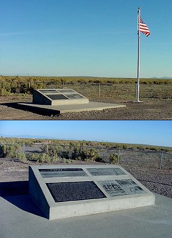
    <summary type="html"><![CDATA[<p><strong><em>A general description of the camp of Topaz and the story of attempted escape and death.</em></strong></p><img src="https://www.intermountainhistories.org/files/fullsize/5214fd4fe0ca6f426e3bd8d3097e073a.jpg" alt="Monument at Topaz Camp Site" /><br/><p>Japanese internment reached its long fingers deep into the interior states of the U.S. not sparing the state of Utah.  Utah's contribution to this program came in the form of Topaz.  Located 15 miles from Delta, Utah, Topaz was created by the War Relocation Agency to house up to 9,000 evacuees.  It would, at its peak, reach a total population 8,232 individuals, and, over the course of its life, Topaz would serve as the home for 11,212 individuals.  These first groups of individuals came mostly from the Tanforan race track that had been converted temporarily into an internment camp.  They were moved into the camp beginning on September 11, 1942.  The camp was constructed in blocks with 34 blocks being devoted to residencies and 8 being administrative, including a hospital built on the site .  Overall, Topaz appeared as a well-developed city with schools, libraries, churches, and other features of a normal community .</p><p>The lack of normalcy in this community was encapsulated by a single event in 1943.  An older gentleman, James Wakasa, was killed while allegedly trying to escape from the camp by crawling under the barbed wire fence.  The local newspaper reported the initial story, that Wakasa had been attempting this escape and was warned four times by the guard before he was fatally shot .  However, a later report by the military showed that he had in fact been standing near the fence when he was shot.  Further investigation revealed that many of the military personnel assigned to guard the camp were combat veterans and this particular guard had seen time in the Pacific, perhaps compromising his objective judgment.  The death of Wakasa brought to the forefront the inherent tensions that existed within the camp between the Japanese American evacuees and the Caucasian administration.  Despite efforts made within the leadership of the camp to eliminate this form of distrust, the fact that the war was still going on and Caucasian Americans were distrustful of most Japanese Americans, citizens or not, was one that could not be passed over lightly.</p><p>In a cruel irony of wartime circumstances, Utah became a place not for refugees as it had been for Mormon Pioneers in the nineteenth century, but one for prisoners of war within their own country.</p><p><em><strong><a href="https://www.intermountainhistories.org/items/show/8">For more (including 3 images) view the original article</a></strong></em></p>]]></summary>
    <published>2017-01-10T23:57:31+00:00</published>
    <updated>2026-04-17T19:31:58+00:00</updated>
    <link rel="alternate" type="text/html" href="https://www.intermountainhistories.org/items/show/8"/>
    <id>https://www.intermountainhistories.org/items/show/8</id>
    <author>
      <name>Benjamin Sowards, Brigham Young University</name>
    </author>
  </entry>
  <entry>
    <title type="html"><![CDATA[Memorializing Mountain Meadows]]></title>
    <summary type="html"><![CDATA[<p><strong><em>This monument honoring the victims of the Mountain Meadows Massacre is a sober one. It tells a story of fear, radicalism, and tragedy. </em></strong></p><img src="https://www.intermountainhistories.org/files/fullsize/52f1afbf2035519af22f18d37ca1543e.jpg" alt="Mountain Meadows Massacre Monument" /><br/><p>In the mid-1850s, the Mormons of Utah were not on friendly terms with the United States of America. Previous persecutions from the government caused Mormons to be distrustful of the United States. The United States saw the Mormon theocracy that existed in Utah and feared its disloyalty. This caused the Utah War, a cold war between the territorial and federal governments. Droughts and pestilence in the mid-1850s caused an extremist movement in Utah called the Mormon Reformation with powerful rhetoric, including a religious capital punishment. The atmosphere of Utah at the time was hostile. </p><p>The Baker-Fancher party of emigrant families was passing through the Southern end of Utah and rumors went with them. Local Mormons feared their intentions and assembled militia and local Paiutes to attack. In a series of attacks from September 7-11, 1857, 120 men, women, and children were killed, leaving only 17 small children alive. After much controversy over who was at fault for the massacre and the extensive efforts to cover up and understand, John D. Lee, one of the men who led the assault, was ultimately convicted and sentenced to death. </p><p>The first monument was built by James H. Carleton in 1859 when he was investigating the massacre for the United States. In shock of what he had seen, he felt the need to build a monument by stacking stones atop one another with a cross at the top. The monument was repeatedly destroyed and rebuilt over the years. Calls for a more honorable and permanent monument were made by the descendants of the Baker-Fancher party and Mormon President Gordon B. Hinckley. While the permanent monument was being built in August 1999, a backhoe dug up the bones of 28 massacre victims. Much controversy went behind whether to study them or to honor them through reburial in time for the dedication. Utah Governor Mike Lee made the decision to not spoil the commemoration of the dead with controversy. The decision was made to honor the dead and allow for the healing of old wounds. </p><p>Historian Levi Peterson likens learning about the massacre to a Greek tragedy. Tragedies tell a story of an honorable hero who falls under a gross misunderstanding. When we view another in the midst of a tragedy, we are capable of escaping our own tragic emotions and seek for healing through catharsis. As one views this monument, one may come seeking healing of their own mistakes.</p><p><em><strong><a href="https://www.intermountainhistories.org/items/show/9">For more (including 4 images) view the original article</a></strong></em></p>]]></summary>
    <published>2017-01-11T00:17:39+00:00</published>
    <updated>2026-04-17T19:31:58+00:00</updated>
    <link rel="alternate" type="text/html" href="https://www.intermountainhistories.org/items/show/9"/>
    <id>https://www.intermountainhistories.org/items/show/9</id>
    <author>
      <name>Jason Colver, Brigham Young University</name>
    </author>
  </entry>
  <entry>
    <title type="html"><![CDATA[The Nunnery]]></title>
    <summary type="html"><![CDATA[<img src="https://www.intermountainhistories.org/files/fullsize/7fd8911778918bad54a0a8a8d8942b72.jpg" alt="Lodge interior. St. Anne&#039;s Retreat. " /><br/><p>Known by various names, including Hatch's Camp, Forest Hills, Pine Glenn, St. Anne's Retreat, and the Nunnery, this historic site is about 6 miles up Logan Canyon in the middle of the Cache National Forest. This former summer camp has been listed on top haunted lists of the US. </p><p>The first owners and developers of the land were the Hatch and Odlum families. Boyd and Anne Hatch and Floyd and Hortense Odum not only developed this land together, but also went into business together starting in the 1920’s and soon became millionaires due to their entrepreneurial efforts. In the 1950s the Hatch family donated the property to St. Thomas Aquinas Parish in Logan. which gladly accepted the property on behalf of the Catholic Church and renamed the camp St. Anne's Retreat. It was only after the Catholic church took over the ownership of the Hatch property that rumors began to take hold of the community, filling the communal mind with images of drowning babies and Satanic nuns. Gary Topping, the archivist of the Catholic Diocese of Salt Lake City, is unaware of any actual crime that would taint the site's reputation in the era when the church used the property as a resort and was unable to find any evidence of any incident in the records of St. Thomas Aquinas Parish. A reporter for the Deseret Morning News was also unable to unearth any evidence backing up local legends. This leads many to believe that these horror stories were created from an environment of prejudice against non-LDS religions in Utah. </p><p>In 1995, Jesse Smith Bushman, a BYU graduate student, conducted a study in which he interviewed two Catholic priests in Utah about their experience as a religious minority in the area during the time that the rumors began about St. Anne’s retreat. These are some of the things they had to say about the LDS church and Catholic relations during the 1950s, “The LDS church and its members tended to overlook the other faiths in the state” and “some adults are still very affected by social barriers and may leave for that reason”. This idea of a “us” versus “them” society is shown in a story that one of the priests shared “about a man who had felt somewhat left out for five years and then after joining the LDS church felt quite accepted." These candid accounts suggest how mistrusting rumors could have started about a non-LDS religious institution. </p><p><em><strong><a href="https://www.intermountainhistories.org/items/show/10">For more (including 2 images) view the original article</a></strong></em></p>]]></summary>
    <published>2017-01-11T00:50:06+00:00</published>
    <updated>2026-04-17T19:31:58+00:00</updated>
    <link rel="alternate" type="text/html" href="https://www.intermountainhistories.org/items/show/10"/>
    <id>https://www.intermountainhistories.org/items/show/10</id>
    <author>
      <name>Taylor Dexter, Brigham Young University</name>
    </author>
  </entry>
  <entry>
    <title type="html"><![CDATA[From Fossils to Conservation: Dinosaur National Monument]]></title>
    <summary type="html"><![CDATA[<p><strong><em>One of the most unique National Parks or Monuments in Utah, Dinosaur National Monument, is home to an enormous fossil quarry. It was also the center of an environmental controversy over reclamation and dam construction in the 1950s.</em></strong></p><img src="https://www.intermountainhistories.org/files/fullsize/318fadb436f495a4195e8c42e66aa223.jpg" alt="Dinosaur National Monument East Entrance" /><br/><p>Dinosaur National Monument consists of over 210 acres of mostly uninhabited land owned by the federal government, 91% of which is managed as Recommended Wilderness. Dinosaur National Monument is unlike the other National Parks Service land in Utah. It is home to almost 26 full dinosaur skeletons from over 10 different species. These fossils were discovered in 1909 by Professor Earl Douglass from Carnegie Museum, who was responsible for excavating the fossils in the quarry. Given that these fossils are 150 million years old, the area was declared a National Monument in 1915 in order to protect the fossils and keep the quarry intact. In 1938, the land of the national monument was expanded to protect the canyons of the Green and Yampa rivers. The National Monument land is not only home to these dinosaurs, but it was home to prehistoric people and archaeological sites as well.</p><p>Fremont Indians inhabited the area for hundreds of years (approximately 200-1300 AD). They have left their mark on the territory, similar to the dinosaurs. There is an abundance of petroglyphs and pictographs within the monument boundaries. Many of these ancient drawings are of animals and other things the Fremont Indians would have interacted with. It is unclear as to why exactly these people left their mark in this way, but they have stood the test of time to show us of their existence in eastern Utah. Other tribes have also inhabited the area since this time, including the Ute and Shoshone tribes. Prior to 20th excavation, the area was also traversed by the  Domínguez-Escalante Expedition in 1776. </p><p>In the early 1950s the Bureau of Reclamation proposed the building of a dam on Echo Park, which is located on the Green River in the National Monument. Many conservationists fought against this proposal because land owned by the National Park Service was not allocated for development. Fortunately for the National Monument, the Council of Conservationists were able to shut down the proposal after six years and dozens of publications. Dams were then built in Glen Canyon and Flaming Gorge to avoid being on any National Park Service land, particularly Dinosaur National Monument. Today the National Monument stands as a reminder of extinct prehistoric creatures, ancient civilizations, and environmental conservation.</p><p><em><strong><a href="https://www.intermountainhistories.org/items/show/40">For more (including 3 images) view the original article</a></strong></em></p>]]></summary>
    <published>2017-05-02T21:43:47+00:00</published>
    <updated>2026-04-17T19:31:58+00:00</updated>
    <link rel="alternate" type="text/html" href="https://www.intermountainhistories.org/items/show/40"/>
    <id>https://www.intermountainhistories.org/items/show/40</id>
    <author>
      <name>Nicole Anderson, Brigham Young University</name>
    </author>
  </entry>
  <entry>
    <title type="html"><![CDATA[Wendover Air Force Base]]></title>
    <summary type="html"><![CDATA[<p><strong><em>Wendover Air Force Base has a short, but rich history. It is responsible for the training of thousands of airplane pilots and bomb testings, including the fighter division that dropped the first atomic bomb in world history.</em></strong></p><img src="https://www.intermountainhistories.org/files/fullsize/76dc54ef567061c7fc9076443908fe68.jpg" alt="Wendover Air Field during World War II" /><br/><p>Created before the U.S. entry in World War II, Wendover Air Force Base [AFB] originally began as a small field in Wendover, Utah. Located on the Utah-Nevada border, the town had a population of only 103 people at the time. In 1941, newly acquired lands increased the base size to make it the largest bombing and gun range in the world at that time. The land was acquired despite the protests of local ranchers and farmers who claimed that it would be detrimental to their income. Wendover AFB’s purpose in WWII was that of a bombing and gun range, testing site, and research center for aircraft warfare. Some of the unique specialties included at Wendover AFB included remote controlled missiles and airplanes, but the main focus was on heavy bombing groups of B-17s and B-24s. Many bombing groups completed their training at the base, including some that flew in D-day and other worldwide operations. Three of the pilots that trained here later earned Medals of Honor for their military service. Wendover AFB also played a part in the preparation to drop the atomic bombs on Japan. Col. Paul W. Tibbets, who led the 509th composite group, chose Wendover for its size and isolation, both necessary for the security of the project. As the project came closer to fruition, the “Little Boy” bomb was assembled and tested at Wendover. After the conclusion of WWII, the use of the wartime air force bases around the nation was reduced. The case was the same for Wendover. Use by the Air Force ceased entirely after 1986, and now the base is used as a museum showcasing the base’s history.</p><p><em><strong><a href="https://www.intermountainhistories.org/items/show/42">For more (including 3 images) view the original article</a></strong></em></p>]]></summary>
    <published>2017-05-08T23:34:40+00:00</published>
    <updated>2026-04-17T19:31:58+00:00</updated>
    <link rel="alternate" type="text/html" href="https://www.intermountainhistories.org/items/show/42"/>
    <id>https://www.intermountainhistories.org/items/show/42</id>
    <author>
      <name>Westin Laing, Brigham Young University</name>
    </author>
  </entry>
  <entry>
    <title type="html"><![CDATA[Ogden’s Bustling Base: Hill Air Force Base]]></title>
    <summary type="html"><![CDATA[<p><strong><em>Considered one of Utah’s largest employers, Hill AFB has had a significant role in shaping the economy and development of Ogden and surrounding municipalities. The base has also served as a means of fostering greater cooperation between Utahans and the US military.</em></strong></p><img src="https://www.intermountainhistories.org/files/fullsize/b07a41bef4ba6af8e96569e8fffa2e7a.jpg" alt="1940 Groundbreaking Ceremony for Hill Field" /><br/><p>Prominently located a mere 30 miles north of Salt Lake City, Hill Air Force Base has become a remarkable feature of Utah’s landscape. Even before its gates opened in 1940, its construction as a Works Progress Administration (WPA) project provided economic grown and prosperity to the region. The base also served as a symbol of changing relationships between Utah locals, the federal government, and the United States military. </p><p>The local and military relationship that existed throughout Utah’s early history can only be described as contentious. Conflicts between Army commanders seeking to increase the military and therefore federal influence in Utah Territory frequently butted heads with the Mormon majority that dominated territorial government and law. Though tensions would decrease, allowing for Utah’s admission as a state, the isolationist and self-sufficient attitudes that were uniquely Mormon would persisted into the 20th century. </p><p>Utah’s limited economic diversity and general reliance on agriculture left much of the state’s population vulnerable to the effects of the Great Depression. In the mid-1930s, the Army Air Corps began expressing interest in building an Air Depot in the Intermountain West, believing an inland position would keep it safe from coastal attacks. Excitement spread throughout Utah as the prospect of the base promised further economic relief and, more importantly, growth. Cities throughout Utah expressed interest in hosting the new Air Base, but none with as much enthusiasm and determination as the local leaders of Ogden, without whom the base might never have been built.</p><p>The promise of full cooperation by Ogden’s leaders and donation of land near the already established Ogden Arsenal brought wavering federal attention for the project back to Utah. A combination of Works Progress Administration and defense funds totaling $30 million were allocated to the construction of the base, and by the end of 1943, Hill Field had become the largest civilian employer in the state. What little opposition that did arise with the base’s construction was limited to criticism of its location in Ogden as opposed to spots in the Salt Lake and Utah Counties.</p><p>During World War II, Hill’s responsibilities consisted of aircraft supply and maintenance, and expanded to include missiles in 1959, when the base received the assignment to manage the Minuteman Intercontinental Ballistic Missile. Just as the base’s responsibilities were expanding, so too were the communities surrounding the base. Housing and transportation shortages prompted rapid growth and development in Ogden and surrounding municipalities.</p><p>Today Hill Air Force Base continues to be one of the largest employers in Utah and a necessary supporting fixture to many businesses in Ogden. While the massive base closures in 1995 brought uncertainty for the base’s future, many have taken comfort in Hill’s assignment as the depot for the Navy, Marine, and Air Force variants of the F-35. It is anticipated that the F-35 will maintain Hill’s significance with the Air Force as whole, keeping the base a permanent fixture in Utah.</p><p><em><strong><a href="https://www.intermountainhistories.org/items/show/43">For more (including 5 images) view the original article</a></strong></em></p>]]></summary>
    <published>2017-05-09T00:02:22+00:00</published>
    <updated>2026-04-17T19:31:58+00:00</updated>
    <link rel="alternate" type="text/html" href="https://www.intermountainhistories.org/items/show/43"/>
    <id>https://www.intermountainhistories.org/items/show/43</id>
    <author>
      <name>Sarah L. Woolley, Brigham Young University</name>
    </author>
  </entry>
  <entry>
    <title type="html"><![CDATA[The Provo River Battle]]></title>
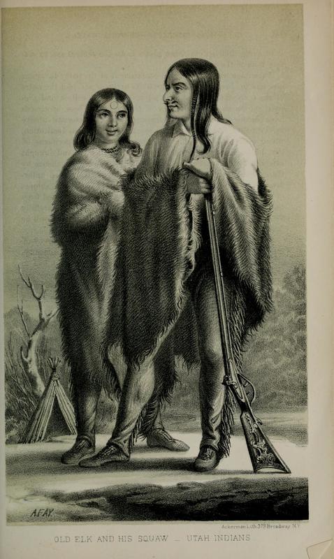
    <summary type="html"><![CDATA[<p><strong><em>While the early Mormon settlement of Utah is often described as less violent than in other places in the West, this ignores significant conflicts. One of these occurred near the current site of Brigham Young University in Provo, Utah.</em></strong></p><img src="https://www.intermountainhistories.org/files/fullsize/27d66b6af040d146480b1e6855c9a325.jpg" alt="Old Elk and his Wife" /><br/><p>Fort Utah, which would eventually become Provo, was established in April 1849. Initial interactions with the nearby Utes were strained, yet Natives visited the fort. Despite tensions over livestock and resources, an uneasy peace was kept for a few months. This came to an unfortunate end when some of the settlers reacted rashly to a minor theft.</p><p>According to settler accounts, in January 1850 a Timpanogos Ute man stole a shirt from a clothesline at the Fort. In attempting to retrieve the shirt, three settlers shot and killed him. They then disposed of the body in the river. Members of the tribe discovered corpse, were enraged by the murder, and prepared to respond in force. To prepare a defense, Peter W. Cownover traveled to Salt Lake City to request reinforcement from the Deseret Militia. The militia left Salt Lake on February 7; in the meantime, the Utes under Big Elk fortified themselves in their camp on the banks of the Provo River. After negotiations failed, a two-day battle ensued. Neither side made significant advance until a final push from the Mormon settlers routed the Utes from their fortification and up towards the mountains. From the Provo River bottoms near present-day Bulldog Blvd. and State St. in Provo, Utes were pushed back towards the mouth of Rock Canyon.</p><p>In the end, Mormon casualties amounted to 1 killed and 18 wounded; of the Utes, at least three were killed including Big Elk and one woman, with an unknown number wounded. A group of the Indians surrendered and were offered asylum inside Fort Utah; another group went South to Spanish Fork and the remainder fled up the hill towards Rock Canyon where they were pursued and shot down, raising Indian casualties to between 40 and 100. One local telling links the naming of a peak above Rock Canyon to Big Elk's widow attempting to scale the cliff and falling to her death.</p><p>In the spring, the surviving Timpanogos Utes carried out raids in the Salt Lake Valley, killed settlers in the Sanpete Valley, and threatened to attack Chief Wakara (Walker) of a rival Ute band for cooperating with the Mormon settlers. Patsowett, the leader of the hostile group, was quickly captured and executed, ending that chapter in Utah’s ongoing Indian wars.</p><p><em><strong><a href="https://www.intermountainhistories.org/items/show/44">For more (including 2 images) view the original article</a></strong></em></p>]]></summary>
    <published>2017-05-09T22:36:31+00:00</published>
    <updated>2026-04-17T19:31:58+00:00</updated>
    <link rel="alternate" type="text/html" href="https://www.intermountainhistories.org/items/show/44"/>
    <id>https://www.intermountainhistories.org/items/show/44</id>
    <author>
      <name>Joshua Bernhard, Brigham Young University</name>
    </author>
  </entry>
  <entry>
    <title type="html"><![CDATA[The First Relief Society Hall]]></title>
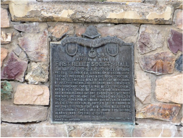
    <summary type="html"><![CDATA[<p><strong><em>The construction of the first Relief Society hall in Santaquin, Utah was an important milestone in the history of the LDS Church. After the hall fell in 1963, a monument was soon built to mark the site and preserve its significant history.</p></strong></p><img src="https://www.intermountainhistories.org/files/fullsize/a689b3a20debe58b66aee311a01a6a98.jpg" alt="Plaque donated by the Daughters of the Utah Pioneers" /><br/><p>In 1842 Joseph Smith organized the Relief Society, the women’s organization in The Church of Jesus Christ of Latter-day Saints.  The Relief Society began by meeting in members’ homes where they taught, nurtured, and served each other as well as other members of the Mormon church, all under the organization’s first president, Emma Smith.  The Relief Society continued to act as an auxiliary organization of the Church while the Mormons resided in Nauvoo, IL, but was disbanded before the trek West to Utah. Various women's groups arose in its stead until church President Brigham Young publicly reconstituted the organization in 1867.</p><p>In 1882, forty years after the Relief Society was created, the First Relief Society Hall was erected in Santaquin, Utah.  Joseph Chatwin constructed the one room structure under the direction of the society’s president, Elizabeth Stickney.  For sixty more years, this hall served the Relief Society until it was sold to Santaquin city in 1942 to serve as a public library and, later, a civic center.  The building remained standing until 1963, when it crumbled to the ground.  This site remained an important part of the history of Santaquin as well as the history of the Relief Society, and The Daughters of the Utah Pioneers created a monument in 1964 to mark the special place. </p><p>This hall in Santaquin, as well as other Relief Society halls throughout Utah and the Western United States, served the women of the Relief Society by providing them a place to serve the community and individuals in need, discuss public issues that involved them, and teach one another their religion. </p><p><em><strong><a href="https://www.intermountainhistories.org/items/show/45">For more (including 3 images) view the original article</a></strong></em></p>]]></summary>
    <published>2017-05-10T16:13:36+00:00</published>
    <updated>2026-04-17T19:31:58+00:00</updated>
    <link rel="alternate" type="text/html" href="https://www.intermountainhistories.org/items/show/45"/>
    <id>https://www.intermountainhistories.org/items/show/45</id>
    <author>
      <name>Elizabeth Hegstrom Cook, Brigham Young University</name>
    </author>
  </entry>
  <entry>
    <title type="html"><![CDATA[Preserving Mesa Verde: Mesa Verde Perservation]]></title>
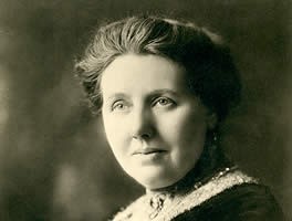
    <summary type="html"><![CDATA[<p><strong><em>The creation of Mesa Verde National Park was a struggle that required the combined efforts of thousands of people who truly believed in the conservation of our nation’s cultural heritage.</em></strong></p><img src="https://www.intermountainhistories.org/files/fullsize/5ac1d1e97033cd5d423891c8f45fd6d5.jpg" alt="Virginia McClurg" /><br/><p>The Ancestral Puebloans</p><p>Mesa Verde National Park is a world heritage site located in Montezuma County, Colorado. Among these ruins lived the Ancestral Puebloan Native Americans. Though historians disagree as to when this culture emerged, the common belief is that the first traces of this culture were seen around the 12th century B.C.E. However, by the time the Spanish made the first explorations into the region, they had migrated southward and no longer inhabited the cliff dwellings at Mesa Verde. The most famous structures of the site are Cliff Palace and Spruce Tree House, containing many dwellings, ladders, and kivas (circular pits used for ceremonial purposes). </p><p>The Importance of Preservation</p><p>While the culture and lifestyle of these people is both fascinating and shrouded in mystery, the purpose of this writeup will be to analyze the history of those who fought to preserve these ruins, as their efforts should not go unnoticed. Mesa Verde National Park was officially founded in 1906, and contains some of the best-preserved Ancestral Puebloan ruins that are in existence. Containing what is generally thought to be the largest cliff dwelling in North America, this site is a favorite for people who have interest in the ancient cliff-dwelling peoples of the region. The site has become a favorite of thousands of people who live in the American West, though this has not happened without much struggle and difficulty. The preservation of archeological remains is a highly controversial topic in American politics and history, and Mesa Verde is no exception. Through the tireless efforts of various archeological organizations, government agencies, and private citizens, this historical gem has been preserved. While there is widespread belief that president Theodore Roosevelt was the driving force behind the preservation of Mesa Verde, there were many unsung heroes who strove to make the ruins a national park and to keep it alive, vibrant, and intact for the benefit of people today.</p><p>The Unheard Crusaders</p><p>Virginia McClurg, a correspondent for the New York Daily Graphic, moved to Colorado Springs, Colorado in 1877 and began to take interest in the ruins. She organized thousands of women and founded the Colorado Cliff Dwellings Association which fought for the preservation of the ruins at Mesa Verde. While many of her goals were not realized, she was able to raise national and international interest in the site and facilitated the passing of the bill that officially designated Mesa Verde as a national park. However, the war was not yet won. The ruins were still only that: ruins. Jesse Walter Fewkes soon stepped in and began to survey the park in order for repairs to be made and the park to be put in working condition. During the Great Depression, the CCC was an essential force in making repairs and building roads. In more modern times, Mesa Verde joined UNESCO in 1978 as a world heritage cultural site.</p><p>Overall, the struggle to preserve Mesa Verde cannot be attributed to one person alone. While many recognize Theodore Roosevelt as the driving force behind preserving the park, there are many others who gave themselves to the effort. Their contributions should not go unrecognized, but should be celebrated. </p><p><em><strong><a href="https://www.intermountainhistories.org/items/show/46">For more (including 2 images) view the original article</a></strong></em></p>]]></summary>
    <published>2017-05-22T18:05:07+00:00</published>
    <updated>2026-04-17T19:31:58+00:00</updated>
    <link rel="alternate" type="text/html" href="https://www.intermountainhistories.org/items/show/46"/>
    <id>https://www.intermountainhistories.org/items/show/46</id>
    <author>
      <name>Nathan K. May, Brigham Young University</name>
    </author>
  </entry>
  <entry>
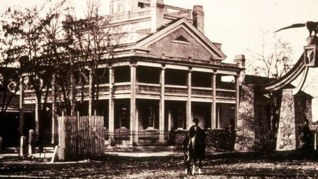
    <title type="html"><![CDATA[The Beehive House of Brigham Young]]></title>
    <summary type="html"><![CDATA[<p><strong><em>“The home was undoubtedly planned in father’s mind through the happy memories of the beautiful colonial buildings in Vermont, his birthplace.”   These words were penned by Clarissa Young Spencer, a daughter of Brigham Young, as she recalled her childhood in the Beehive House. The house served as Brigham Young’s primary residence following its completion in 1854 until his death.</em></strong></p><img src="https://www.intermountainhistories.org/files/fullsize/984716657eaee063d17107e9c8504e3a.jpg" alt="Beehive House of Brigham Young" /><br/><p>Built in 1854 in Salt Lake City, Utah the Beehive house was home to Brigham Young, the 2nd president of the Church of Jesus Christ Latter-day Saints. It was designed in the Greek Revival style of architecture by Truman O. Angell. The original adobe walls were painted in a soft yellow, with green shutters over the windows, and a large front door with a silver door-knob.  Spencer recalled how the house was used to entertain many guests.  Such entertainments took place in what was called the “long hall.” The Utah State Historical Society records that the home welcomed visitors including “President Ulysses S. Grant, Emperor Dom Pedro of Brazil, General William T. Sherman, Ralph Waldo Emerson, Mark Twain, Jay Gould, Horace Greeley, and even the midget Tom Thumb and his tiny wife.”  Young lived there with his wife Mary Ann Angell, who moved back to the White House, a separate property owned by Brigham Young in Salt Lake City “about a block east of the Lion House.”  Lucy Ann Decker and her children moved into the house in 1860 and Lucy remained there until the end of Brigham’s life.  The house was also home to men who worked on the Young estate as well as immigrant girls who had nowhere to go. Spencer recalled “Mother always used to say that everyone who didn’t have any other place to go was sent to her.” </p><p>Other features of the house included an attic, two parlors, Brigham Young’s room, a cellar, and a porch which Spencer recalls as a young woman was “a most convenient place to set out onto” to listen to serenading young men.  A family store was also added at the back of the house where there had originally been a barn.  The store was stocked to provide goods for the families of Young’s various wives. Brigham Young is known to have had at least 56 plural wives, as confirmed by the LDS Family History Archives. Only one wife and her children ever lived at the Beehive house at a time. Others lived in other homes owned by Young, many lived at the nearby Lion House. Spencer recorded that “there were usually about twelve families living in the Lion House.” </p><p>When Brigham Young died in 1877 Lucy Ann Decker was given the house in the estate settlement, and in 1888 she sold it to a son of Mary Ann Angell, John W. Young. In 1889, he began to remodel the house, which included a large Victorian addition in the back. However, he was a businessman, and when he suffered financial troubles, the house was foreclosed by the bank and sold at an auction to John Beck, who also eventually suffered financial troubles. The house was then purchased by the LDS church in 1899.  Since that time it has served as the home of LDS Presidents Lorenzo Snow and Joseph F. Smith, then in 1920 it was given to the LDS Young Ladies Mutual Improvement Society to be run as a home for young women who came to the city for work or school. In 1959 it was converted into a museum. </p><p><em><strong><a href="https://www.intermountainhistories.org/items/show/47">For more (including 3 images) view the original article</a></strong></em></p>]]></summary>
    <published>2017-05-22T21:45:35+00:00</published>
    <updated>2026-04-17T19:31:58+00:00</updated>
    <link rel="alternate" type="text/html" href="https://www.intermountainhistories.org/items/show/47"/>
    <id>https://www.intermountainhistories.org/items/show/47</id>
    <author>
      <name>Devin Hart, Brigham Young University</name>
    </author>
  </entry>
  <entry>
    <title type="html"><![CDATA[Emigration Canyon: The Arrival of the Saints]]></title>
    <summary type="html"><![CDATA[<p><strong><em>In late July, 1847, the first party of Mormon pioneers entered the Salt Lake Valley, traveling through Emigration Canyon in the Wasatch Mountains. Within two days, the pioneers erected a permanent settlement at City Creek, near modern-day Temple Square in Salt Lake City. The arrival of the Mormons commenced a new era of history in Utah, attracting thousands of eager Mormon settlers to cultivate and transform the land. </em></strong></p><img src="https://www.intermountainhistories.org/files/fullsize/98f4d1a60528ad40bcbebc195b6bd91f.jpg" alt="Emigration Canyon" /><br/><p>On July 21st, 1847, after a grueling journey of 108 days, Erastus Snow and Orson Pratt had the distinction of being the first Mormon pioneers to descend from Emigration Canyon into the Salt Lake Valley, after following the remnants of a rough road through the Wasatch Mountains most recently blazed by the Donner-Reed Party. Pratt’s words capture the grandeur of that moment, “After issuing from the mountains . . . and beholding, in a moment, such an extensive scenery open before us, we could not refrain from a shout of joy . . . the grand and lovely scenery was in our view”. Although the Mormons were not the first Euro-Americans, or even emigrants, to pass through Emigration Canyon into the Salt Lake Valley, their arrival represented a dynamic transition in the history of Utah, which the Mormons would dominate from that point onward. </p><p>The day after Snow and Pratt first glimpsed and scouted the valley, the Mormon pioneers already began to reshape both the route through Emigration Canyon and the valley itself. On July 22nd, a crew from the advance wagon party lead by Stephen Markham cut a road through Donner Hill in just four hours, creating quick and suitable route around the hill that taxed the Donner-Reed Party’s animals the previous year. On the same day, led by Orson Pratt, eight members of the advance party made their way down into the Salt Lake Valley to locate a suitable location for planting. Finding the soil to be more fertile closer to the mouth of Emigration Canyon, the party discovered an area near City Creek, a “beautiful creek of pure water” according to Pratt, that would become the first settling point for the Mormon pioneers. On July 23rd, while the advance company began plowing acres of land and damming City Creek, Brigham Young, ill with “mountain fever”, made the journey over Little and Big Mountains and camped near what Orson Pratt called Last Creek, prepared to take the final 6 miles of the journey the following day.</p><p>On July 24th, now celebrated as Pioneer Day, the ailing Brigham Young descended into the Salt Lake Valley in one of Wilford Woodruff’s wagons, entering sometime after noon, and as recorded in Woodruff’s journal, “expressed his full satisfaction in the Appearance of the valley as A resting place for the Saints.” Brigham Young triumphantly entered the City Creek camp at 2 PM, finding 5 acres of potatoes planted, which the Saints irrigated at noon from the creek, thus beginning the great work of molding the Salt Lake Valley into a suitable home for the Mormons. Although the infamous words of Brigham Young, “this is the place” were not recorded until 33 years later by Wilford Woodruff in a speech commemorating the Mormon church’s 50th anniversary, “This is the Place” monument, completed in 1947 by Brigham Young’s grandson Mahonri Young, immortalized the Mormons’ arrival into the Salt Lake Valley on those July days in 1847, which would transform the land and history of Utah forever.</p><p><em><strong><a href="https://www.intermountainhistories.org/items/show/48">For more (including 3 images) view the original article</a></strong></em></p>]]></summary>
    <published>2017-05-24T01:05:38+00:00</published>
    <updated>2026-04-17T19:31:58+00:00</updated>
    <link rel="alternate" type="text/html" href="https://www.intermountainhistories.org/items/show/48"/>
    <id>https://www.intermountainhistories.org/items/show/48</id>
    <author>
      <name>Luke Eckstrom, Brigham Young University</name>
    </author>
  </entry>
  <entry>
    <title type="html"><![CDATA[The Provo Tabernacle]]></title>
    <summary type="html"><![CDATA[<img src="https://www.intermountainhistories.org/files/fullsize/9f6dd6d1984dba4f5888aa0b75d76add.jpg" alt="A view of the old Provo Tabernacle" /><br/><p>The original Provo Tabernacle, located in Provo Utah, was constructed and funded in 1856 by members of the Church of Jesus Christ of Latter-day Saints (LDS). The building was dedicated in 1867 by LDS prophet John Taylor and subsequently used as a meetinghouse for meetings and conferences, as well as a gathering place for social events. The building was too small to accommodate the needs of the Church so construction began in 1883 to build a larger tabernacle directly south, and the original one was demolished. William Folsom served as the Church architect for the second Provo Tabernacle. The Gothic architecture was chosen so that the structure would be styled after English Presbyterian buildings. The construction finished in 1886 at a cost of 100,000 dollars. Two years later George Q. Cannon, a member of the First Presidency of the LDS Church, dedicated the building.</p><p>The tabernacle was used for religious conferences as well as special events in the community such as graduations, funerals, and lectures by visitors. Prominent visitors include president William Howard Taft, violinist Fritz Kreisler, and pianist Sergei Rachmaninoff. The building underwent numerous renovations during the years to be updated and accommodate larger audiences. The Provo Tabernacle was listed in the National Register of Historic Places in 1975.</p><p>In December 2010, the tabernacle caught fire. The Provo Fire Department reported that the fire was an accident and was caused by a “technician setting a light fixture on a wooden speaker box in the attic.” The fire destroyed the building’s roof and interior. Fire Marshall Lynn Schofield estimated the losses from the fire equaled 15 million dollars. In October 2011, the LDS Church announced plans to restore the tabernacle, a meeting place for worship, into an LDS temple, a sacred building where members of the LDS church perform special forms of worship. The following year they undertook the huge task of engineering a temple from the gutted, barely free standing brick exterior of the original building. In 2016, the Provo Tabernacle was dedicated as the Provo City Center Temple.</p><p><em><strong><a href="https://www.intermountainhistories.org/items/show/94">For more (including 4 images) view the original article</a></strong></em></p>]]></summary>
    <published>2017-09-19T17:07:10+00:00</published>
    <updated>2026-04-17T19:31:59+00:00</updated>
    <link rel="alternate" type="text/html" href="https://www.intermountainhistories.org/items/show/94"/>
    <id>https://www.intermountainhistories.org/items/show/94</id>
    <author>
      <name>Shantel Fitzgerald, Brigham Young University</name>
    </author>
  </entry>
  <entry>
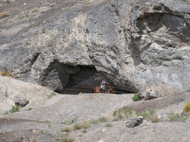
    <title type="html"><![CDATA[Danger Cave]]></title>
    <summary type="html"><![CDATA[<p><strong><em>Formed by the waves of Lake Bonneville, Danger Cave served as the home to Native American as far back as 11,000 years.  The excavation of Danger Cave by a University of Utah archaeological team in the mid-20th century has given us unique insight to the lives of those Native people who survived in the harsh desert climate of the Great Basin.</em></strong></p><img src="https://www.intermountainhistories.org/files/fullsize/10c11ecad6c13f685f449f95dfb39142.jpg" alt="Danger Cave Fenced Off" /><br/><p>The barren deserts of North America have always been viewed with fascination due to the lack of natural resources. Early human survival in this region was extremely hard, and the mid-20th century excavation of Danger Cave greatly expanded understanding of regional history. Danger cave is an archaeological site located in the Bonneville Basin of western Utah, north of Wendover and west of the Bonneville Salt Flats. Danger Cave State Park Heritage Area became a National Historic Landmark in 1961 and a state park in 1968. This cave is one of the most significant archaeological sites in North America because it reshaped the way that we think about Utah’s Native peoples.</p><p>Danger Cave was formed about 13,000 years ago under the waves of Lake Bonneville. When the water levels of the lake lowered, people began living in the cave. Native Americans are thought to have begun living inside of this cave about 11,000 years ago, right after the end of the Ice Age. It had been inhabited by different native people consistently after that, so archaeologists discovered layers and layers of artifacts in this cave. These native people left behind fascinating evidence of their existence inside of Danger Cave. </p><p>Despite the challenging working conditions in the cave, which included dust and heat, the cave was excavated throughout the 1940s and 1950s by anthropology students attending the University of Utah. Jesse Jennings was a faculty member at the University who led the exaction project that has reshaped the way we think of the early people of the Great Basin. The large amount of artifacts found makes it one of the most important sites in North American history and gives us a better idea of how early Native Americans survived in the barren desert of western Utah. </p><p>The extremely dry climate in the cave made it a perfect place to store artifacts and human remains for over 11,000 years. Inside of the cave textiles, baskets, pottery, animal bones, plant remains, weapons, chipped stones, and leather scraps were all found. Radio-carbon dating proved this site to be one of the oldest known Native American sites in North America. </p><p>The artifacts and data collected from Danger Cave taught us about the previously unknown ancient cultures of the western deserts. Findings in the cave suggest that these people lived in relatively small groups of 15-30 individuals, that consist mostly of extended families. The search for food was what dictated their lives, and these groups moved around constantly searching and they had little time for leisure activities. They had no building projects and no complicated rituals. The main focus of their lives were to survive and to have enough food. </p><p><em><strong><a href="https://www.intermountainhistories.org/items/show/95">For more (including 4 images) view the original article</a></strong></em></p>]]></summary>
    <published>2018-01-16T18:22:15+00:00</published>
    <updated>2026-04-17T19:31:59+00:00</updated>
    <link rel="alternate" type="text/html" href="https://www.intermountainhistories.org/items/show/95"/>
    <id>https://www.intermountainhistories.org/items/show/95</id>
    <author>
      <name>Ashley Olson, Brigham Young University</name>
    </author>
  </entry>
  <entry>
    <title type="html"><![CDATA[Beginnings of Big Cottonwood Canyon: Brighton Village&#039;s Forerunner, William S. Brighton]]></title>
    <summary type="html"><![CDATA[<p><strong><em>William Stuart Brighton felt pulled to emigrate to America from Scotland with his young family in 1855. After a pioneer journey westward, he went on to establish mining rights in Big Cottonwood Canyon, and later build the Brighton Hotel. His contributions to the early days of Big Cottonwood Canyon led to a bustling canyon for summer recreationists in the late-19th century and a thriving ski resort village today.</em></strong></p><img src="https://www.intermountainhistories.org/files/fullsize/1627f38e1dc242119d9c0d7d2d61d269.jpg" alt="Early Brighton Home" /><br/><p>Before there was a ski resort, homes, and a fire station at the head of Big Cottonwood Canyon, there was a tract of wild land open for use. William Stuart Brighton established Brighton Camp, and then Brighton Village. William Brighton, his wife Catherine, their two children Janet and Mary, and his sister Annie, came to America from Scotland in 1855, and traveled west in 1857. They experienced a difficult journey, burying Mary at sea and little Janet walking barefoot across the plains. The Brighton family created a famous center for recreation and leisure when they built Brighton Hotel. Their contributions made a significant difference in Salt Lake society, with visitors flocking to the mountains for good food, dancing, and beautiful scenery. </p><p>William Brighton stood with his colleague, Joseph Elder, at the top of Big Cottonwood Canyon in 1870 and drew lots to see who would claim mining rights in Little or Big Cottonwood Canyons. Brighton drew Big Cottonwood Canyon. He brought his family, which had grown to include sons Robert Alexander, William Henry, Thomas Bow, and Daniel H., to the area, at first living in a tent, but by 1872 had built a one-room cabin. A mining boom in the Alta area brought many miners through their land, going between Park City and Alta, and the Brightons began to host them. The miners liked Catherine’s cooking, and eventually persuaded the couple to build Brighton Hotel in 1874 to more formally host their many visitors. The Brighton Hotel quickly became a popular summer destination, hosting some of the most prominent Salt Lake people. The area was a romantic escape from the hustle and bustle of the city below, and was described as having excellent fishing and beautiful wildflowers, and its scenery inspired many. The family often hosted bonfires and dances for the whole canyon, where they enjoyed listening to the fiddle and the accordion. Popular lakes around the hotel were named by the Brightons and other residents of the canyon; for example, it is said that the German artist Bornimann named Lake Catherine after Catherine Brighton, who renamed Dog Lake to Silver Lake, due to the way that it shimmered in the early morning. </p><p>By 1895, the Brightons had opened a small store, a post office, and second hotel. They also had the only telephone in whole canyon. The canyon swelled with summer visitors, drawn to the beauty of the mountains and the hospitality of the Brightons. Sadly, in 1894, Catherine died of a heart attack, with William passing away nine months later, in 1895, of blood poisoning from an infected sliver in his finger. The Brightons’ contribution to the canyon as a place of recreation and inspiration is unequaled and is of sure sentimental value to the history of Big Cottonwood Canyon.</p><p><em><strong><a href="https://www.intermountainhistories.org/items/show/96">For more (including 3 images) view the original article</a></strong></em></p>]]></summary>
    <published>2018-01-16T19:34:27+00:00</published>
    <updated>2026-04-17T19:31:59+00:00</updated>
    <link rel="alternate" type="text/html" href="https://www.intermountainhistories.org/items/show/96"/>
    <id>https://www.intermountainhistories.org/items/show/96</id>
    <author>
      <name>Abigail Clayton, Brigham Young University</name>
    </author>
  </entry>
  <entry>
    <title type="html"><![CDATA[The Great Gallery: Defining Barrier Canyon Rock Art]]></title>
    <summary type="html"><![CDATA[<p><strong><em>Hidden within the confines of Horseshoe Canyon, vestiges of an ancient people from 7,000 years ago repose on the canyon wall. The figures, as large as 7 feet tall, tantalize historians today with the mystery of their purpose and meaning, defining an entire style of indigenous American rock art.  </em></strong></p><img src="https://www.intermountainhistories.org/files/fullsize/267e4d38115d6911f57060ea9fd0cbc5.jpg" alt="Discovery of the Great Gallery" /><br/><p>The Great Gallery itself consists of a ~200-300 foot stretch of a rock wall on the side of Horseshoe Canyon in Canyonlands National Park in southeastern Utah. It features approximately 80 figures created with a red ocher-tinted paint. The pictographs and petroglyphs have been attributed to the Archaic people, a civilization that lived in Horseshoe Canyon over 7,000 years ago.  These pictographs are similar to a variety of other rock art found in the Four Corners region but their influence and prominence in studies as well as the multitude of similar artwork in the canyon led Polly Schaafsma in the 1970s to name this entire strain of rock art the Barrier Canyon Style (as Horseshoe Canyon was previously named).</p><p>Due to the ancient nature of the rock art, no single interpretation of the Great Gallery is guaranteed to be true. Many ethnographers have suggested that these murals were created for a variety of purposes such as hunting rituals, illustrating myths and traditions, recreation, or shamanistic magic.  As for what the symbols themselves mean, the majority of the tall angular figures without appendages are thought to represent people. Some of the larger, more decorative figures are understood to be shamans. Their special decorative heads represent either the headdresses the shamans wore or the spiritual power these shamans possessed. Other figures included are those of animals or plants important to the Archaic people.  </p><p>Evidence of the Archaic people has been found in Utah dating back to 6,500 BC. They were a hunter-gatherer culture that migrated throughout the desert climate of the Colorado Plateau. This culture’s most recognizable and distinctive features include their rock art, twig figurines similar to the figures seen in the Great Gallery, and the baskets they wove. They used a spear thrower called an atlatl in order to hunt down their food and grinding stones to crush seeds to eat, allowing for a varied diet.</p><p>As stated before, the Great Gallery is a particularly important selection of Barrier Canyon Style rock art. In fact, the Great Gallery pictographs were deemed so important, that a faithful replica was commissioned in the 1940s under Franklin D. Roosevelt’s New Deal program the Works Progress Administration. The mural, created by prominent Utah artist Lynn Fausett, was originally placed in the Museum of Modern Art in New York City before being moved to Denver during WWII for safe keeping and then traveling around the country until it finally settled at the Utah Museum of Natural History in 1969.  A variety of methods have been used to date the art including radiocarbon dating and superposition, but these often do not help form a consensus.  For instance, in 2014, a team of scientists led by geologist Joel Pederson used a method of rock dating called optically stimulated luminescence (OSL) used damage from a rock slide to determine that this section of the Great Gallery must have been created between 900 and 2,000 years ago.  Other scientists maintain that radiocarbon dating of other artifacts in the area that look almost exactly like those in the pictographs support a much earlier dating.  Time will reveal the answers to these mysteries as we understand more about the Great Gallery.</p><p><em><strong><a href="https://www.intermountainhistories.org/items/show/97">For more (including 3 images) view the original article</a></strong></em></p>]]></summary>
    <published>2018-01-16T19:51:49+00:00</published>
    <updated>2026-04-17T19:31:59+00:00</updated>
    <link rel="alternate" type="text/html" href="https://www.intermountainhistories.org/items/show/97"/>
    <id>https://www.intermountainhistories.org/items/show/97</id>
    <author>
      <name>Brandon Sheeder, Brigham Young University</name>
    </author>
  </entry>
  <entry>
    <title type="html"><![CDATA[Wasatch Academy]]></title>
    <summary type="html"><![CDATA[<p><strong><em>In 1875 Presbyterian Reverend, Duncan McMillan arrived in the heart of Mormon country on a mission to make inroads with the predominantly LDS population. The best way to reach the people of Utah during the late nineteenth century was to build a school, an institution which most communities found to be lacking. While the school set off religious tensions between the with the Church of Jesus Christ of Latter-day Saints, the school was able to provide an education to the students of Utah communities during a time when they needed it most. Today, Wasatch Academy still stands as a functioning boarding school for students in Utah, the greater United States, and the world. </em></strong></p><img src="https://www.intermountainhistories.org/files/fullsize/083e2db3227ff947e2dc10ae4385053f.jpg" alt="Wasatch Academy Dormitories" /><br/><p>Located in Utah’s Sanpete County, in the town of Mount Pleasant, Wasatch Academy has stood for over a hundred years. The history of the site can be traced back to the arrival of the Reverend Duncan James McMillan in Mount Pleasant on March 2, 1875. His arrival to some marked the beginning of the Presbyterian Church, of which he was affiliated, in Mount Pleasant the next day, yet his memorable impact for the church came with the establishment of a school. The beginnings of the Wasatch Academy for him were difficult, yet he was determined to do all that he could in the Mormon country of Utah. Upon his arrival, he befriended the local, non-Mormon postmaster and “learned that there was a real opportunity for service among the Mormons.” The service of which he referred was the need for schools in the area. Though Reverend McMillan did not have the funds to start a school himself, he was able to receive the funds to pay for the old Liberal Hall to be used as the school building from the Women’s Missionary Society in Cedar Rapids, Iowa. </p><p>The school helped to bring education to students of the area. Wasatch Academy, then referred to as the Liberal Hall, first opened to students on April 19, 1875 with a student enrollment of only forty-four. The number rose to one hundred and nine students by the end of the first term. The school, as with many other Presbyterian schools under the Home Missions established in the United States, provided women an opportunity to serve as teachers. Delia R. Snow was one such teacher from 1875 to 1878, after having been the first convert in the area to the Presbyterian faith. Her experience underlines the religious, as well as educational, mission of Reverend McMillan and the Presbyterians in Mount Pleasant. The main focus for the Wasatch Academy was to establish a school because Reverend McMillan noted that “[the Mormons] had no school system… and as he looked out upon that pioneer territory he seemed to hear the command of the Master, ‘Feed my lambs.’” Indeed the school was able to provide education in various subjects and across all levels by 1887. </p><p>Wasatch Academy eventually saw need to expand out of its original home in order to progress. Work began on the new building in 1888, but it would eventually give way to changes again in 1910 as the structure of the school systems and demand shifted in Utah. Wasatch Academy would continue to undergo changes in curriculum and physical structure throughout the decades. Currently, Wasatch Academy is a private boarding high school that focused on preparing its students for higher education.  The current Wasatch Academy does not have religious affiliations, despite its early history, and serves a wide, global student body.  It’s original home of Liberal Hall has since been purchased and renovated by Wasatch Academy to function as a museum to tell the history of the school in the region and where it all began.</p><p><em><strong><a href="https://www.intermountainhistories.org/items/show/98">For more (including 3 images) view the original article</a></strong></em></p>]]></summary>
    <published>2018-01-17T19:23:14+00:00</published>
    <updated>2026-04-17T19:31:59+00:00</updated>
    <link rel="alternate" type="text/html" href="https://www.intermountainhistories.org/items/show/98"/>
    <id>https://www.intermountainhistories.org/items/show/98</id>
    <author>
      <name>Samantha R. Beck, Brigham Young University</name>
    </author>
  </entry>
  <entry>
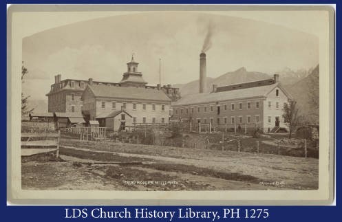
    <title type="html"><![CDATA[The Provo Woolen Mills]]></title>
    <summary type="html"><![CDATA[<p><strong><em>Today there is nothing left of the Provo Woolen Mills, but for a third of Provo’s history they were one of the most prominent landmarks in the city. The complex of buildings that made up the Mills covered a whole city block, and the biggest building was four stories tall. Between 1873 and 1932, they employed hundreds of workers, many of whom were immigrants from Europe who had grown up working in woolen mills in their home countries.</em></strong></p><img src="https://www.intermountainhistories.org/files/fullsize/254916fe4bb6f068e841407ee651b5b5.jpg" alt="The Mills around 1890" /><br/><p>The Mills were built in the 1870s at a time in Utah’s history when the leaders of the Church were trying hard to keep Utah’s economy closed. Between 1847 and 1869, Utah had been a tightly-knit Mormon community where almost everything that was grown or made by Mormons -- fruit, wool, furniture -- was sold to other Mormons. Church members believed that this economic restriction would help keep them spiritually strong and safe from the dangers of wild capitalism. However, in 1869 the transcontinental railroad was built through Utah, upsetting the balance by making cheap worldly merchandise easy for the Saints to buy. In response, Brigham Young decided to build his own wool factory in Provo.</p><p>The Mills opened for business in 1873, and for their first thirty years they were a success. Between 1880 and 1900 sheep herding became very popular in Utah, and shepherds from Utah Valley and beyond made lots of money selling their wool to the Mills, where it was turned into coats and blankets and sold to other Utahans. However, the depression of the 1890s slowed down business, and the Mills closed in 1904. In a risky business decision, Jesse Knight, Provo’s famous philanthropist, bought the factory in 1910 and renamed it the Knight Woolen Mills, but it continued to suffer financial trouble, perhaps because the Church by now had reversed its economic policies and members were buying cheaper clothes from bigger companies, perhaps because of a fire in 1918 that destroyed a lot of wool and machinery. The Great Depression was too much for it, and it closed for good in 1932. Its sixty years of existence across a period of great change in Utah history tell a complicated story of faith, money, and wool.</p><p><em><strong><a href="https://www.intermountainhistories.org/items/show/100">For more (including 4 images) view the original article</a></strong></em></p>]]></summary>
    <published>2018-01-17T19:58:32+00:00</published>
    <updated>2026-04-17T19:31:59+00:00</updated>
    <link rel="alternate" type="text/html" href="https://www.intermountainhistories.org/items/show/100"/>
    <id>https://www.intermountainhistories.org/items/show/100</id>
    <author>
      <name>Jonathan Reil, Brigham Young University</name>
    </author>
  </entry>
  <entry>
    <title type="html"><![CDATA[Springville Art Museum]]></title>
    <summary type="html"><![CDATA[<img src="https://www.intermountainhistories.org/files/fullsize/5ce834410d6a5697a04bbb68d13cdd6f.jpg" alt="Exterior of Museum" /><br/><p>If you enjoy art and live in Utah County, then the Springville Art Museum is a must visit location. The Springville Art Museum was built in 1937 by the WPA (Works Progress Administration) and dedicated by David O. McKay. It is located on 126 East and 400 South in Springville Utah. It is the first and the oldest art museum in Utah for the visual fine arts. The history of the Museum dates back to 1903 when the founders, John Hafen and Cyrus E. Dallin donated artwork to Springville High School. This helped to encourage the arts throughout the area and to have a location where people could come and enjoy the artwork of others and receive their own inspiration. </p><p>The Museum has over 2,500 art pieces in 29 galleries included in its collection and also hosts and displays over 15 exhibitions annually from artists around the globe. The building has had two additions.  In 1964 a two story wing was added and in 1998, 20,000 square feet was added on for space that is focused on education for children and also extra room for the permanent collection. Many families, including Emma and George Smart, Alice and Merlin Steed, Theodore Wassmer and Judy Lund-Wassmer, donated art pieces that have added to the total of around 2,500 pieces that are housed in the museum year round. </p><p>The Springville Art Museum is still visited by thousands of people today who go to see the art pieces and exhibits on display. They also host different kinds of events at the Museum including dances, parties, art events, and other types of festivities. The community is very involved in the Museum from the children attending local high schools having some of their art put on display at the venue as well, which is always an exciting thing for aspiring artists. It truly is a wonderful place to go and view art and even admire the building itself for the historical meanings it has there in Springville Utah. </p><p><em><strong><a href="https://www.intermountainhistories.org/items/show/101">For more (including 2 images) view the original article</a></strong></em></p>]]></summary>
    <published>2018-01-18T18:54:55+00:00</published>
    <updated>2026-04-17T19:31:59+00:00</updated>
    <link rel="alternate" type="text/html" href="https://www.intermountainhistories.org/items/show/101"/>
    <id>https://www.intermountainhistories.org/items/show/101</id>
    <author>
      <name>Summer Sutherland, Brigham Young University</name>
    </author>
  </entry>
  <entry>
    <title type="html"><![CDATA[Japanese Youth at Topaz]]></title>
    <summary type="html"><![CDATA[<img src="https://www.intermountainhistories.org/files/fullsize/f8d2cdcd9325fab8e55f03f687e7b6ad.jpg" alt="WRA Pre-school" /><br/><p>The young, second-generation Japanese immigrants (Nisei) relocated to the Topaz Mountain Internment Camp during World War II faced a unique challenge. Born in American to the children of Japanese immigrants, they were forced to negotiate between being legal citizens and being seen as outsiders. After Pearl Harbor in 1942, President Roosevelt signed Executive Order 9066 creating the Military Exclusion Zones along the Pacific Coast. The order pushed 120,000 Japanese out of their homes and into internment camps, including Topaz. The intention was to protect America against any immigrants whose allegiance was still with Japan. The youth were directly confronted with the issue in the form of the Loyalty Exam. Two of the questions read, “Are you willing to serve in the armed forces of the United States on combat duty, wherever ordered?” and, “Will you swear unqualified allegiance to the United States of America . . . and foreswear any form of allegiance to the Japanese emperor, to any other foreign government, power, or organization?” These questions were the basis of the “Yes-Yes” and “No-No” groups that caused division among their age group and all within the camp. </p><p>The forced relocation led Japanese young people like Miné Okubo and Yoshiko Uchida to turn to art, journals, and letters to compile the effects the movement had on Japanese family structure and their own dreams of education or social advancement. These forms of communication expressed a worry for their people, confusing and hurt over being sent to internment camps, and the desire to still support the America they had been born into. This extended into subsequent post-war Sansei generations as well. <a href="https://www.rasasaki.com/about/" target="_blank" rel="noreferrer noopener">R. A. Sasaki</a>, a third-generation San Franciscan, captured this desire in her short story American Fish. The main character, Mrs. Hayashi, is asked by an old acquaintance, Mrs. Nakamoto, why Mrs. Hayashi’s parents stayed in the United States after Pearl Harbor. Mrs. Hayashi answered simply, “I guess they knew that we, I mean my brothers and sisters and I would never want to go to Japan. I mean we were born here. We belonged here. And they wanted the family to stay together.” </p><p>Despite their circumstances, Japanese-American youth held on to the hope of an America that offered opportunity. They created from scratch, along with teachers and administrators, a successful school with limited resources. In fact, many of the students complained in interviews later in life about the lack of credible teachers and resources. The draw to a world they had grown up in, like Yoshiko Uchida who continually applied to go to college while in Topaz, highlighted the difficult situation these Japanese Americans were in. They believed in a nation who could give them everything, but were left to wonder why they were building their own prison walls when they were more than willing to fight for the nation that they were both “born” to and “belonged” in.</p><p><em><strong><a href="https://www.intermountainhistories.org/items/show/167">For more (including 6 images) view the original article</a></strong></em></p>]]></summary>
    <published>2018-05-11T20:13:25+00:00</published>
    <updated>2026-04-17T19:32:02+00:00</updated>
    <link rel="alternate" type="text/html" href="https://www.intermountainhistories.org/items/show/167"/>
    <id>https://www.intermountainhistories.org/items/show/167</id>
    <author>
      <name>Chad Weight and Alex Hauber, Brigham Young University</name>
    </author>
  </entry>
  <entry>
    <title type="html"><![CDATA[Alkali Ridge<br />
]]></title>
    <summary type="html"><![CDATA[<p><strong><em>Alkali Ridge (Alkali Point) is a National Historic Landmark located in San Juan County near the city Blanding in the state of Utah. The site was found and dug by Archaeologist John O. Brew. The remains in the site show the transition of Ancestral-Pueblo culture from hunter-gatherer to a horticulture lifestyle. (c. 700 C.E – 1150 C.E.)</p></strong></p><img src="https://www.intermountainhistories.org/files/fullsize/2f709ec704253117e79d1bcda0af2973.jpg" alt="Alkali Ridge (Outer stone bricks of ruins)
" /><br/><p>Alkali Ridge (also known as Alkali Point), is one of the sites archaeologist John O. Brew excavated in Utah (1932-1934). The site is near the city Blanding, Utah in the San Juan county (consisting of the southeast corner of Utah). The Four Corners region of the southwest United States was where the ancestral Pueblo or “Anasazi” resided from c.1000 B.C. until c. 1300 A.D. when, for unknown reasons, they left Utah. The Alkali Ridge site contains the remains of a village full of ceramics and pottery pieces. The village spans an area of 240x500 feet and provides an average density of 200 remain sites (ruins, pottery) per square mile. </p><p>The site has a wide time range due to the ruins spanning from the Basketmaker III period (c.450 C.E.-750 C.E.) until the Pueblo II period (c.900 C.E.- 1150 C.E). The site shows the transition from pit dwellings, a time when the Anasazi culture were hunter and gatherers, to a change to surface homes and a horticultural lifestyle. Also found are several cliff dwellings, structures built into the sides of cliffs with walls and covers. The village consisted of about 185 units, situated in four rows. The older buildings and pit structures were built from mixtures of mud and water, formed into bricks. Newer buildings began using better stone masonry. Each group had a newer pit structure called a kiva, which served for ceremonial and communal purposes. These newer pit structures were often deeper than their predecessors and had a room that connected to the main chamber. Several rooms were used for the storage of corn. Ceramics of varying style can be found throughout the ruins. Roads (though worn terribly down by time) link the various cluster of villages in this area and are thought to have served the purpose of trade connections to the other scattered villages of the Puebloan I-II periods c.750 C.E. to c.1150 C.E. </p><p>Alkali Ridge was made a National Historic Landmark in 1964. It is under the jurisdiction of the Blanding Bureau of Land Management.</p><p><em><strong><a href="https://www.intermountainhistories.org/items/show/306">For more (including 3 images) view the original article</a></strong></em></p>]]></summary>
    <published>2019-02-15T09:54:52+00:00</published>
    <updated>2026-04-17T19:32:05+00:00</updated>
    <link rel="alternate" type="text/html" href="https://www.intermountainhistories.org/items/show/306"/>
    <id>https://www.intermountainhistories.org/items/show/306</id>
    <author>
      <name>McKay Morris, Brigham Young University</name>
    </author>
  </entry>
</feed>