<?xml version="1.0" encoding="UTF-8"?>
<feed xmlns="http://www.w3.org/2005/Atom">
  <title type="text">Intermountain Histories</title>
  <updated>2026-08-18T15:51:51+00:00</updated>
  <generator uri="http://framework.zend.com" version="1.12.20">Zend_Feed_Writer</generator>
  <link rel="alternate" type="text/html" href="https://www.intermountainhistories.org/"/>
  <link rel="self" type="application/atom+xml" href="https://www.intermountainhistories.org/items/browse?output=rss2"/>
  <id>https://www.intermountainhistories.org/</id>
  <author>
    <name>Intermountain Histories</name>
    <uri>https://www.intermountainhistories.org</uri>
  </author>
  <link rel="hub" href="https://pubsubhubbub.appspot.com/"/>
  <entry>
    <title type="html"><![CDATA[Yellowstone’s Favorite President’s Monument: Roosevelt Arch: Story 1 of 8 of the President Theodore Roosevelt in the West Tour]]></title>
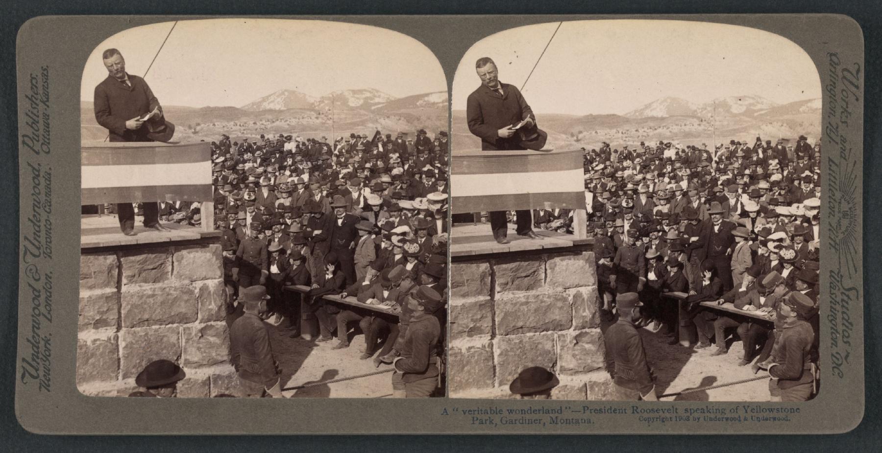
    <summary type="html"><![CDATA[<p><strong><em>Yellowstone receives an upgraded welcome with the Roosevelt Arch and gets a surprise visitor, Theodore Roosevelt, to dedicate it. </em></strong></p><img src="https://www.intermountainhistories.org/files/fullsize/f5ae52940338461ed18d1b83497abbb0.jpg" alt="President Roosevelt addresses a crowd at the dedication of Roosevelt Arch" /><br/><p>“Dedicated and set apart as a public park or pleasuring-ground for the benefit and enjoyment of the people.” Roosevelt Arch is a hearty welcome on the North entrance side of Yellowstone National Park. Standing at 52 feet, this monument is a symbol ofthe cultural and natural significance of the Park. Erected in 1903, the arch spanned what was at the time the park’s only entrance. Visitors passed under the arch from Gardiner, Montana, taking stagecoaches into Yellowstone. Army Co Engineer, Hiram M. Chittenden, the idea man, said, “...the natural features of the country at this portion of the boundary are about the least interesting of any part of the Park, and the first impression of visitors upon entering the Park was very unfavorable.” Accordingly, he proposed the arch as a beautiful park entry. Construction began on February 19, 1903 and a dedication ceremony was planned for April 24, 1903 to coincide with Roosevelt's planned visit to the park.</p><p>Yellowstone Park officials asked Roosevelt to participate in the event. This was a perfect opportunity for his conservation efforts and love for the park. With great fanfare, Roosevelt shared, “The geysers, the extraordinary hot springs, the lakes, the mountains, the canyons, and cataracts unite to make this region something not wholly to be paralleled elsewhere on the globe.” His love for the land was shared with the visitors there. They added a time capsule in the arch containing local newspapers, a bible, Masonic documents, a picture of President Roosevelt, and U.S. coins, among other items.
Roosevelt Arch still stands as a ceremonial welcoming committee to Yellowstone. Although not as popular as it was in the 20th century because of changing traffic patterns, automobiles couldn’t take the route like stagecoaches had, it is still a valuable spot to visit when exploring the park. Multiple entrances being added make this an out-of-the-way stop for those accessing the park from the more popular southern and western entrances. Yellowstone is visited by approximately 4 million people annually, and the arch continues to be a popular destination, especially for those visiting the Mammoth area or arriving from points north. It was added to the National Register of Historic Places in 2002 and is a potent symbol and reminder that National parks are “For the benefit and enjoyment of the people” as Theodore Roosevelt referenced the Act Congress passed in 1872 making Yellowstone a public park in his speech, and is not engraved on a place at the top of the arch itself.</p><p><em><strong><a href="https://www.intermountainhistories.org/items/show/919">For more (including 4 images) view the original article</a></strong></em></p>]]></summary>
    <published>2025-10-24T15:03:17+00:00</published>
    <updated>2026-08-18T15:51:51+00:00</updated>
    <link rel="alternate" type="text/html" href="https://www.intermountainhistories.org/items/show/919"/>
    <id>https://www.intermountainhistories.org/items/show/919</id>
    <author>
      <name>Jessika Cole, Brigham Young University</name>
    </author>
  </entry>
  <entry>
    <title type="html"><![CDATA[1988 Fire Season, Yellowstone National Park]]></title>
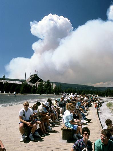
    <summary type="html"><![CDATA[<p><strong><em>Starting in the 1970s, Yellowstone National Park experimented with a policy that allowed natural fires to burn within park boundaries. In 1988, a series of highly destructive wildfires put this policy to the test, leading to a comprehensive review of the National Park Service’s fire management procedures. </em></strong></p><img src="https://www.intermountainhistories.org/files/fullsize/cbe39d48527aa1fc2d28fe58044f461b.jpg" alt="Wildfire smoke behind Old Faithful Lodge, 1988" /><br/><p>In 1972, the United States National Park Service (NPS) adopted Yellowstone National Park’s first fire management plan, which allowed natural fires to burn in designated parts of the park. In 1976, a revised plan expanded this controversial approach, called prescribed natural fire or the “let-burn” policy, to impact the entire park. Historically, fires played a key role in thinning forests and clearing dry, dead plants from the landscape, and species like lodgepole pine trees rely on extreme heat from fires to release their seeds and reproduce. In theory, prescribed natural burning maintained these conditions and controlled the damage fires caused. While smoke pollution from let-burn events caused controversy throughout the 1970s, they scorched only 34,175 of Yellowstone's 2,221,800 acres between 1977 and 1988. The Park Service extinguished any fires that threatened people, buildings, or roads.
In the summer of 1988, dry weather and high winds created dangerous conditions in Yellowstone. On June 14, 1988, lightning sparked the Storm Creek Fire just north of the park near Cooke City, Montana, and it gradually made its way into Yellowstone’s boundaries. Initially, NPS allowed about twenty lightning-caused fires, including Storm Creek, to burn in every corner of Yellowstone. Without rainfall to dampen their impact, wind spread the fires rapidly. By July 15, the Park Service suspended the let-burn policy and fought every fire that threatened the park.
The public idolized Yellowstone as the first national park and a crown jewel of the park system, so the 1988 fires rapidly generated a significant media presence in Yellowstone and caused public backlash. By August, the Cable News Network (CNN) and National Broadcasting Company (NBC) sent reporters to the park and presented daily fire updates. When the largest blaze in the park, the North Fork Fire, threatened the historic Old Faithful Inn on September 7, reporters and their viewers blamed NPS officials and the let-burn policy for allowing the fires to spread out of control. A week later, presidential candidate Michael Dukakis visited the park to generate publicity for his campaign, symbolizing the fires’ grip on national media.
             When snow finally ended the fires in November, fifty-one total fires had burned 995,000 acres, damaging about forty-five percent of the park. They destroyed sixty-seven structures in total, including thirty-six privately owned homes, garages, and stores. The North Fork Fire alone scorched approximately 495,000 acres. After the fires, two review committees found that they represented a perfect storm of natural conditions that made them incredibly difficult to fight, but politicians and the media continued to place blame on NPS management strategies. On July 12, 1989, the Park Service began a systematic review of its fire management procedures. Its new policy, approved in 1991, set detailed limits on the prescription and containment of natural fires, rolling back much of the let-burn approach. Firefighters still use prescribed burns and let-burn management to maintain healthy forests in national parks today, sustaining the 1991 policy.</p><p><em><strong><a href="https://www.intermountainhistories.org/items/show/917">For more (including 4 images) view the original article</a></strong></em></p>]]></summary>
    <published>2025-09-23T15:39:30+00:00</published>
    <updated>2026-04-17T19:32:21+00:00</updated>
    <link rel="alternate" type="text/html" href="https://www.intermountainhistories.org/items/show/917"/>
    <id>https://www.intermountainhistories.org/items/show/917</id>
    <author>
      <name>Kaylen Wilson, Northern Arizona University </name>
    </author>
  </entry>
  <entry>
    <title type="html"><![CDATA[Yellowstone Lake’s Steamships and the Legacy of E.C. Waters]]></title>
    <summary type="html"><![CDATA[<p><strong><em>Yellowstone Lake, in Yellowstone National Park, is the largest high-elevation lake in North America. Visitors arrive eager to take in the mountains, glacial waters, and wildlife that surround it. Concessionaire E.C. Waters ran a lucrative steamship operation transporting guests across its waters for two decades, but his business practices and violations of park regulations led to its downfall.</em></strong></p><img src="https://www.intermountainhistories.org/files/fullsize/68c1a5bf36f9944b8e2ad2d694d1d81e.jpg" alt="Map of Yellowstone Lake area, National Park Service (modified)" /><br/><p>Congress established Yellowstone in 1872 as the country’s first and largest national park. Soon after, potential concessionaires flocked to build visitor services within park boundaries. In choosing leaseholders, early administrators strove to balance conservation and tourist accessibility. Increased transportation options would bring more people to the area, companies argued, and encourage the government to allocate funds to protect Yellowstone from vandalism and poaching. In 1886, following a decade of haphazard operations, the Yellowstone Park Association (YPA) took advantage of the park’s rise in popularity. The Northern Pacific Railroad-financed company took over property leases from the previous bankrupt concessionaire. The sites spanned across the park, including one at Yellowstone Lake.
E.C. Waters began as the general manager of the YPA’s hotels in 1887. Aiming to improve the quality of park-wide accommodations, the company planned a sophisticated hotel located on Yellowstone Lake. The site’s remoteness called for boat transportation, as stagecoach travel could be uncomfortable and slow. In 1889, the YPA named Waters president of its Yellowstone Lake Boat Company to meet this demand.
The entrepreneur, though, was already making enemies across the company and the Interior Department. In 1890, the YPA fired him for extortion, poaching, and a geyser’s eruption by throwing soap into it. Yellowstone officials barred him from the park, but his connection with President Benjamin Harrison’s son got him reinstated that same year. In 1892, the Interior Department granted him a permit to transport visitors on his steamship, the <em>Zillah</em>, from Thumb Bay to the Lake Hotel area. The 125-passenger vessel was sent piece-by-piece from Minnesota and reassembled at the lake. By 1896, the <em>Zillah</em> was making stops at E.C. Waters' “zoo” on Dot Island. It was a little more than some corralled bison and elk, which he shipped in from outside the park. Passengers were unknowingly charged extra by Waters for the quick stop. To make matters worse, the bison and elk starved as his finances declined and operations fell into disrepair. Park administrators and visitors questioned the <em>Zillah</em>’s lakeworthiness, Waters’ concession license, and his overall moral character.
Regardless, Waters built another steamship, the <em>E.C. Waters</em>, in 1905. It could carry 500 passengers, a violation of the park’s capacity limits. Fed up with his antics, park administrators refused to reinstate his lease and booted Waters from Yellowstone in 1907. A 1921 storm berthed the <em>E.C. Waters</em> on an island close to the hotel without ever transporting a single visitor. Park officials salvaged its parts over the next decades, most notably its boiler, which heated the Lake Hotel until the mid-twentieth century. What exactly became of the <em>Zillah</em> is unknown. Boat concessions continued after E.C. Waters sold his company in 1907, but the days of steamships and zoos were gone. Now, officials restrict lake operations to a tour boat, some motorboats, and paddle sports like kayaks. Visitors can still spot the skeleton of the <em>E.C. Waters</em> where it was shipwrecked years before, a testament to the hubris and ambition of its namesake.</p><p><em><strong><a href="https://www.intermountainhistories.org/items/show/889">For more (including 6 images) view the original article</a></strong></em></p>]]></summary>
    <published>2025-09-23T15:30:18+00:00</published>
    <updated>2026-04-17T19:32:20+00:00</updated>
    <link rel="alternate" type="text/html" href="https://www.intermountainhistories.org/items/show/889"/>
    <id>https://www.intermountainhistories.org/items/show/889</id>
    <author>
      <name>Anaëlle DePoint, Northern Arizona University</name>
    </author>
  </entry>
  <entry>
    <title type="html"><![CDATA[Sheep Eaters (Mountain Shoshones) in the Greater Yellowstone Ecosystem]]></title>
    <summary type="html"><![CDATA[<p><strong><em>The Sheep Eaters (also known as Mountain Shoshones, Tukudika, or Snake Indians), resided in Yellowstone National Park, the Wind River Mountains in Wyoming, and parts of central Idaho, until the reservation era.</p></strong></p><img src="https://www.intermountainhistories.org/files/fullsize/5a9a77ddc55c952bffe2d127a3c16817.jpg" alt="Tukudika (Sheepeater) men, women, and children at Medicine Lodge Creek, Idaho, in 1871." /><br/><p><span style="font-weight:400;">Much of the history of the Sheep Eaters emanates from archeological and ethnographic research. Many scholars believe their origins are in the Great Basin, though that continues to be debated. Trappers like Osborne Russell were among the first Euro-Americans to leave written accounts about the Sheep Eaters. Russell noted that a group of about 22 Sheep Eaters he met were “neatly clothed in dressed deer and Sheep skins of the best quality and seemed to be perfectly contented and happy … [They had] about 30 dogs on which they carried their skins, clothing, provisions etc on their hunting excursions. They were well armed with bows and arrows pointed with obsidian…” Early descriptions provide useful information, but they also often encouraged stereotypes. For example, Philetus Norris, Superintendent of Yellowstone National Park in 1877, described the Sheep Eaters as “vanished” and “hermits."</span>
<span style="font-weight:400;">The Sheep Eaters domesticated dogs they used to carry packs and pull travois. Their name came from their main source of food, Rocky Mountain Bighorn Sheep, which the dogs may have assisted in hunting. Pots and pipes carved from steatite represent another distinguishing characteristic of Sheep Eater culture.</span>
<span style="font-weight:400;">The Sheep Eaters participated in the Rocky Mountain fur trade from the 1820s through the 1850s. During the 1870s, the Lemhi Valley Agency was created to oversee the removal of the Sheep Eaters, Bannocks, and Shoshones to Lemhi Valley in central Idaho. In 1880, they began to be relocated to Fort Hall, but some Sheep Eaters remained in Yellowstone, eventually joining the Eastern Shoshones on the Wind River Reservation. Idaho censuses continued to list Sheep Eaters as a distinct group through the early part of the twentieth century.</span>
<span style="font-weight:400;">It is important to note that the Sheep Eaters did not “vanish” or go extinct as Norris and others described. </span><span style="font-weight:400;">Today, some of the Sheep Eater descendants live on the Wind River Reservation in Wyoming and the Fort Hall Reservation in Idaho. </span>
<span style="font-weight:400;">In 2023, the town of Jackson, Wyoming issued a land acknowledgement concerning the Sheep Eaters:</span>
<ul>
<li><em><span style="font-weight:400;">We recognize that the land we are gathering on is the ancestral homeland of the Mountain Shoshone People who stewarded it for thousands of years and that many other tribes also lived upon and cared for this area … With gratitude, we honor Indigenous peoples, past and present. We also acknowledge the sovereignty of the Native nations closest to Jackson whose land was taken through broken treaties that resulted in the creation of the Wind River and Fort Hall Indian Reservations. We recognize this acknowledgement is simply a first step. The Town of Jackson is committed to continued and informed action to connect with Indigenous people.</span></em></li>
</ul></p><p><em><strong><a href="https://www.intermountainhistories.org/items/show/887">For more (including 3 images) view the original article</a></strong></em></p>]]></summary>
    <published>2025-04-19T02:12:32+00:00</published>
    <updated>2026-04-17T19:32:20+00:00</updated>
    <link rel="alternate" type="text/html" href="https://www.intermountainhistories.org/items/show/887"/>
    <id>https://www.intermountainhistories.org/items/show/887</id>
    <author>
      <name>Emmaretta Barnett, Brigham Young University</name>
    </author>
  </entry>
  <entry>
    <title type="html"><![CDATA[Rebranding Mount Doane to First Peoples Mountain in Yellowstone]]></title>
    <summary type="html"><![CDATA[<p><strong><em>Mount Doane, a prominent mountain in Yellowstone National Park, was named in honor of Lt. Gustavus Doane, an early explorer of the park. However, his mistreatment of Native people has led the park to collaborate with Native communities to rename the peak First Peoples Mountain. </em></strong></p><img src="https://www.intermountainhistories.org/files/fullsize/890b4c397eef6073bf635775a998d2aa.jpg" alt="Mounts Doane and Stevenson, east of southwest arm of Yellowstone Lake" /><br/><p>Lieutenant Gustavus C. Doane ventured through Yellowstone National Park in the early 1870s on a commission by the United States government to explore the western territory. In 1871, the Hayden Geological Survey named a prominent mountain after the military leader, effectively preserving his legacy. Mount Doane stood as a monument to the lieutenant’s efforts and exploration in the West. But this narrative by the Geological Survey left much untold. </p><p>Doane participated in several conflicts with Native people including the Sioux War, the Nez Perce War, and the Apache Campaign in the years leading up to his exploration of Yellowstone. In 1870, he led an attack against the Piikani/Piegan Blackfeet, now known as the Marias Massacre. On January 23, 1870, the United States Army attacked Chief Heavy Runner’s Piegan village at dawn, killing some 173 people, including elderly and children. The camp had been ravaged by smallpox, leaving them defenseless. Such an atrocity went unacknowledged while Mount Doane stood as a legacy to one of the men who perpetrated it. </p><p>To better represent Indigenous peoples and their histories, Yellowstone National Park sought to change the name of Mount Doane and other controversially named sites. The park reached out to organizations like the Rocky Mountain Tribal Council and the Wyoming Board of Geographic Names. In collaboration with and recommendations by these groups, the National Park Service changed the peak’s name to First Peoples Mountain on June 9, 2022. With a vote of 15-0 in support of the change by the US Board on Geographic Names, the mountain became a monument to the memory of the people killed in the Marias Massacre. This change marks an important shift in the ways Indigenous peoples are represented in the historical narrative and historical memory. </p><p><em><strong><a href="https://www.intermountainhistories.org/items/show/855">For more (including 2 images) view the original article</a></strong></em></p>]]></summary>
    <published>2024-09-25T04:33:01+00:00</published>
    <updated>2026-04-17T19:32:19+00:00</updated>
    <link rel="alternate" type="text/html" href="https://www.intermountainhistories.org/items/show/855"/>
    <id>https://www.intermountainhistories.org/items/show/855</id>
    <author>
      <name>Lauren Barney, Brigham Young University</name>
    </author>
  </entry>
  <entry>
    <title type="html"><![CDATA[Old Faithful Inn - Yellowstone National Park]]></title>
    <summary type="html"><![CDATA[<p><strong><em><span style="font-weight:400;">When the Northern Pacific Railroad’s Upper Geyser Basin Hotel burned to the ground on November 17, 1894, the U.S government pressured the railroad to replace it with new tourist accommodations. The result was Old Faithful Inn, which utilized a new style of architecture to highlight Yellowstone’s iconic landscape. </span></em></strong></p><img src="https://www.intermountainhistories.org/files/fullsize/eddddd6f4d185123b8615299ae39a69b.jpg" alt="Old Faithful Inn, Entrance Drive" /><br/><p><span style="font-weight:400;">On March 1, 1872, President Ulysses S. Grant officially signed Yellowstone into law as America’s first national park. The Yosemite Act of 1864 had restricted settlement in the Yosemite Valley and placed it under the jurisdiction of California’s state government, but the Yellowstone Park Act expanded upon this legislation by designating all of Yellowstone a public park. As a result, the Yellowstone Park Act contained many restrictions on private development and very few administrative procedures to enforce regulations or oversee public use. Poorly supervised independent companies called concessionaires, who paid park administrators a fee to use the land, ran Yellowstone’s public facilities. Only a few concessionaires ferried guests into the park, but the Northern Pacific Railroad quickly expressed interest in Yellowstone’s small tourism industry.</span>
<span style="font-weight:400;">When the Northern Pacific reached Gardiner, Montana, in the early 1880s, its presence provoked interest in Yellowstone’s tourism industry. At this time, only a few concessionaires opened small hotels and tent camps. One such concessionaire, the Yellowstone Park Improvement Company, constructed the Upper Geyser Basin Hotel in 1885 to preserve its failing business. The Northern Pacific purchased its properties in 1885, gaining control of the Upper Geyser Basin Hotel. When fire destroyed it</span><span style="font-weight:400;"> in 1894,</span><span style="font-weight:400;"> the importance of a new hotel in Yellowstone became clear</span><span style="font-weight:400;">. At the time</span><span style="font-weight:400;">, many railroad hotels utilized conventional architectural styles that provided a sense of familiarity for their upper-class audience. The Northern Pacific’s Lake Hotel, constructed in 1890, followed this example. However, </span><span style="font-weight:400;">rustic architecture, which emphasized harmony with the natural environment surrounding a structure, gained popularity in the 1890s. Because distinctive architecture drew more attention from visitors, the Northern Pacific experimented with a rustic style for its new hotel. </span>
<span style="font-weight:400;">The Yellowstone Park Association, a subsidiary of the Northern Pacific, selected Robert Reamer to design its new rustic hotel. The railroad constructed the log building near Yellowstone’s most famous geyser, from which the Old Faithful Inn derived its name. </span><span style="font-weight:400;">The Union Pacific completed the central core of the hotel, known as the “Old House,” in 1903.</span><span style="font-weight:400;"> The finished building was seven stories tall at its highest point, and it cost a total of $140,000 (about $4.9 million today) to construct. The Northern Pacific set aside a further $25,000 (approximately $875,000 today) to furnish the new hotel. Reamer designed his massive log structure to emulate Swiss chalets and Norwegian villas, and he utilized rough, unfinished wood logs obtained in the Park on both the inside and outside of the building to connect it to Yellowstone’s forested landscape. The hotel’s most prominent feature is its seven-story lobby, which features a vast fireplace made of native stone. A complex log frame that supports the hotel’s roof surrounds this room. The structure’s use of exposed wooden supports emphasizes the rustic nature of the lobby, and a series of wooden balconies overlook the main floor of the hotel. </span></p><p><em><strong><a href="https://www.intermountainhistories.org/items/show/839">For more (including 5 images) view the original article</a></strong></em></p>]]></summary>
    <published>2024-05-29T19:43:03+00:00</published>
    <updated>2026-04-17T19:32:19+00:00</updated>
    <link rel="alternate" type="text/html" href="https://www.intermountainhistories.org/items/show/839"/>
    <id>https://www.intermountainhistories.org/items/show/839</id>
    <author>
      <name>Kaylen Wilson, Northern Arizona University</name>
    </author>
  </entry>
  <entry>
    <title type="html"><![CDATA[Rocky Mountain Herbarium]]></title>
    <summary type="html"><![CDATA[<p><strong><em>Aven Nelson was originally an English professor but was unexpectedly thrust into the world of botany after being hired at the University of Wyoming in 1893. He discovered a passion for the subject, eventually leading to the creation of the Rocky Mountain Herbarium. Over the years, the herbarium has assembled a collection of 1.3 million specimens through extensive collection efforts and collaborations.</em></strong></p><img src="https://www.intermountainhistories.org/files/fullsize/a9b0acfa38d3d30d1c75600955782178.jpg" alt="Rocky Mountain Herbarium collection sites" /><br/><p><span style="font-weight:400;">The Rocky Mountain Herbarium is at the University of Wyoming in Laramie, Wyoming. Aven Nelson, one of the original faculty members,  established the herbarium in 1893. The university initially hired Nelson as an English professor, but the board of directors made him the biology professor when the school mistakenly employed two English professors. This position led to Nelson discovering his passion for botany. His interest in botany grew as he assisted the university's resident plant expert, Burt Buffum, in identifying plant samples for the Chicago World's Fair in 1893. Nelson's journey in botany continued with his exploration into the Yellowstone National Park in 1899. His journey gained him respect within the botany field, leading to the official establishment of the herbarium as part of the University of Wyoming, with Nelson as its curator. He named it </span><i><span style="font-weight:400;">The Rocky Mountain Herbarium.</span></i><span style="font-weight:400;"> Nelson later became the president of the American Society of Plant Taxonomists and Botanical Society of America and the president of the University of Wyoming from 1918 to 1922.</span></p><p><span style="font-weight:400;">       Following Nelson's resignation in 1930, the herbarium experienced additional growth with the installation of the W. G. Solheim Mycological Herbarium. Added to the herbarium by the head of the university botany department, Dr. Wilhelm G. Solheim, it was Solheim's personal collection of fungi. With 48,000 fungi specimens, it is the largest collection of fungi globally. In 1960, the herbarium collection, comprising around 265,000 samples, moved to the Aven Nelson Memorial Building. Initially constructed as the university's first library in 1923, the building provided a new home for the expanding herbarium. The herbarium collection further grew in 1982 when the US Forest Service National Herbarium (USFS), founded in Washington, D.C., granted an indefinite loan of 120,000 plant specimens. Between the Rocky Mountain Herbarium's personal collection, W. G. Solheim Mycological Herbarium, and the collaboration with the USFS, the herbarium archives now contain over 1.3 million plant samples. This collection has earned the reputation of being one of the largest herbariums between St. Louis and the West Coast.</span></p><p><em><strong><a href="https://www.intermountainhistories.org/items/show/821">For more (including 4 images) view the original article</a></strong></em></p>]]></summary>
    <published>2024-05-21T21:49:59+00:00</published>
    <updated>2026-04-17T19:32:18+00:00</updated>
    <link rel="alternate" type="text/html" href="https://www.intermountainhistories.org/items/show/821"/>
    <id>https://www.intermountainhistories.org/items/show/821</id>
    <author>
      <name>Cristal A. DeSantiago, Northern Arizona University</name>
    </author>
  </entry>
  <entry>
    <title type="html"><![CDATA[Canyon Lodge at Yellowstone National Park]]></title>
    <summary type="html"><![CDATA[<p><strong><em>The historic Canyon Lodge hosts a variety of dining options, indoor and outdoor areas for eating and resting, and a gift shop. It was the first Mission 66 project in the nation and exemplifies form and function in architecture.</em></strong></p><img src="https://www.intermountainhistories.org/files/fullsize/5b51b784f3f902f9b9f18b001c535c11.jpg" alt="Lounge rendering" /><br/><p>Established in 1872, Yellowstone National Park had been selected by the Park Service to be the inaugural project for Mission 66 since it was the first national park. Like most national parks, planning for new building projects started well before the introduction of Mission 66 in the 1950s but received funding when the Eisenhower administration approved the ten-year program which aimed at upgrading park infrastructure in response to the post-World War II visitor boom. In February 1956, the Park Service signed a contract with the Architectural firm Welton Becket & Associates from California; by June, the park broke ground for Canyon Village. Due to the severity of Yellowstone National Park winters, planning and construction periods were narrow. Part of the construction plans included 300 cabins that would be used as motel rooms. Due to a $1 million budget mistake, Welton Becket & Associates and the Park Service increased the number of cabins to 512 to try to create more revenue for the park and recover from the budget fault.
The dedication ceremony of the Canyon Visitor Center took place in August 1957, and the Canyon Lodge opened shortly after. After opening, the Canyon Visitor center operated until 2006 when it closed for renovations. The Park Service had the cabins demolished in 2013 to make room for a modern hotel. 
The original Canyon Village Lodge featured a mid-century modern architectural style adapted to the natural surroundings of Yellowstone National Park. Little of the original Canyon Lodge remains today. To accommodate for an increase in visitors, renovators relocated restrooms outside, allowing more space inside for seating and visitor traffic throughout the building. The original structure had been constructed with stone, concrete, wood, and glass. Xanterra Parks and Resorts renovators relocated a bar in the dining area in 1964 and covered the wooden floors with carpet in 1985. Translucent walls were replaced by concrete, and all the original furnishings have been removed, except for one couch. Original features including fireplaces and wooden mantels have survived the renovations and add a touch of history to the interior of the space. The glass walls have remained unaltered as well. On the exterior, new roofing plans have been in the works to add flat roofs, but the architects are concerned about snowfall buildup causing a collapse. For now, the pitched roofs remain. The Yellowstone National Park Canyon Village Lodge still serves as one of the main stops in the park for visitors to relax and find a bite to eat.</p><p><em><strong><a href="https://www.intermountainhistories.org/items/show/518">For more (including 3 images) view the original article</a></strong></em></p>]]></summary>
    <published>2021-10-15T09:59:27+00:00</published>
    <updated>2026-04-17T19:32:11+00:00</updated>
    <link rel="alternate" type="text/html" href="https://www.intermountainhistories.org/items/show/518"/>
    <id>https://www.intermountainhistories.org/items/show/518</id>
    <author>
      <name>Jennifer John, Northern Arizona University</name>
    </author>
  </entry>
  <entry>
    <title type="html"><![CDATA[Nez Perce and Bannock Flight Through Yellowstone National Park]]></title>
    <summary type="html"><![CDATA[<p><strong><em>The Nez Perce and Bannock Wars were sparked by increasing federal involvement in Indian affairs and Native rejection of reservation life and its implications. During both wars, groups traveled through the newly created Yellowstone National Park, hoping to find refuge in familiar territory as they tried to reach Canada.</em></strong></p><img src="https://www.intermountainhistories.org/files/fullsize/5518ac3fda9f6bef77651017d5de6dfb.jpg" alt="Chief Joseph" /><br/><p>By the late 1870s, the United States government was fully engaged in the process of forcing American Indians in the West onto reservations. In 1855, Nez Perce in Oregon, Idaho, and Washington signed a treaty in which they accepted a 5,000-square-mile reservation. Later, in 1869, their reservation was reduced in size following the discovery of gold on their land. A division grew between some converted Christian Nez Perce who supported treaties and traditional Nez Perce who refused to live on the reservation. One traditional Nez Perce leader argued, “I belong to the land out of which I came.” Groups led by White Bird, Looking Glass, and Chief Joseph separated from the treaty group. In June of 1877, a violent outburst from White Bird’s group left four white settlers dead. The anti-treaty Nez Perce feared retaliation and fled in an effort to join Sitting Bull in Canada.</p><p>The Nez Perce headed through Yellowstone National Park in late August. Yellow Wolf recalled that Nez Perce scouts “knew that country well before passing through there in 1877. The hot springs and high-shooting water were nothing new to us.” On their second day in the park, scouts found a group of tourists and held the party captive for two days. Following a skirmish that left one of the tourists severely wounded, they were released. Some anxious scouts would attack other groups and kill two tourists. The Nez Perce were able to outmaneuver the army as they exited the park, and almost reached Canada before being forced to surrender in October at the Battle of Bear Paw. Around sixty Nez Perce were able to escape during the battle, including White Bird and Chief Joseph’s daughter, who successfully joined the Lakota in Canada. Between 1878 and 1880, many of them returned to Idaho. </p><p>Similarly, in 1878, Bannocks faced starvation at Fort Hall. Ranchers had destroyed important camas bulb pastures, their main source of food, and the government neglected to supplement with sufficient rations. Many Bannocks left the reservation and clashed with white farmers and federal troops. A small band headed north, following the Nez Perce route through Yellowstone National Park, hoping to reach Canada. They were ambushed east of the park in September, and the uprising was eventually quelled by federal troops. Restrictions were placed on the Fort Hall Reservation and most of the insurgents were split up between allotments and other forts.  </p><p>These conflicts damaged Yellowstone’s public relations image and park officials would work hard to assuage tourist fears of an Indian threat. Some tourists found the battles exciting, and in efforts to live out fantasies about the ‘wild west’ joined expeditions following the path used by the Nez Perce and Bannock. Others feared continued Indian contact and avoided the area altogether. The wars also caused a shift in military management of the park; officials would use the conflict to justify military necessity to the park’s success and took a firm stance against Indian presence in the park. </p><p><em><strong><a href="https://www.intermountainhistories.org/items/show/345">For more (including 4 images) view the original article</a></strong></em></p>]]></summary>
    <published>2019-09-26T01:22:58+00:00</published>
    <updated>2026-04-17T19:32:06+00:00</updated>
    <link rel="alternate" type="text/html" href="https://www.intermountainhistories.org/items/show/345"/>
    <id>https://www.intermountainhistories.org/items/show/345</id>
    <author>
      <name>Allie Patterson, Brigham Young University</name>
    </author>
  </entry>
  <entry>
    <title type="html"><![CDATA[Indian Removal from Yellowstone National Park]]></title>
    <summary type="html"><![CDATA[<p><strong><em>When Yellowstone was created as America’s first National Park, Indian presence was seen as a threat to tourism and to government officials in the area. Yellowstone saw little of the ensuing battles between American Indians and federal troops, but the area remained an important source of tension as Indian land claims were disputed and reconsidered. </em></strong></p><img src="https://www.intermountainhistories.org/files/fullsize/b6f0b39fa9f81bee3717d3813c2741f6.jpg" alt="[Untitled]" /><br/><p>For centuries, American Indians used natural resources available in what now constitutes Yellowstone National Park as part their seasonal migration cycles. One band of Shoshone, the Tukudika or Sheep Eaters, lived in the higher elevations of Yellowstone and were considered the park’s only year-round residents. Other groups, including the Crow, Blackfeet, Bannock, Nez Perce, and Shoshone used the region seasonally for hunting, gathering food, and trading. The mountains of Yellowstone were popular vision quest sites, and the geysers and hot springs were believed to house spirits. The area was also a source of important mineral deposits, including obsidian which was used to make weapons and tools.  </p><p>In the Fort Laramie treaties of 1851 and 1868, the government had agreed that land in the Yellowstone area belonged to multiple Native groups. However, as the area grew in popularity among miners and travelers alike, Natives found their access to resources in the park increasingly restricted. At negotiations for the second Fort Laramie Treaty, Crow leader Black Foot said, “My grandfathers advised the nation of the Crow to be good. How can we be good when you take our lands, promising in return so many things which you never give us?” </p><p>In 1872, President Ulysses S. Grant signed the Act of Dedication, creating Yellowstone as the country’s first national park. The act was meant to protect the area’s resources from miners and lumber companies, as well as from ‘lawless’ rural whites and Indians.</p><p>The Tukudika remained in the park for seven years after its creation; they weren’t part of reservation negotiations and saw nearby reservations as a convenience. Largely believed to have been wiped out by smallpox or other Indians, most of them likely joined the Eastern Shoshone at Wind River in 1879. </p><p>Under Superintendent Norris in the 1870s and 80s, park officials heavily discouraged Indian presence in the park, believing it a deterrent to tourist traffic. Park officials downplayed the historical roles of Indian groups in the area and spread rumors that Indians were afraid of the park’s geysers. Yellow Wolf, a Nez Perce participant in the Nez Perce war, recalled instead that “the hot springs and high-shooting water were nothing new to [them].” In 1886 the US Army assumed control of the park and would use violence to deter Indians from returning. </p><p>1896 Supreme Court case Ward v. Race Horse decided that the legislation that had established Yellowstone as a national park was the legal foundation for efforts to keep Indians off public land. However, they continued to use the park, avoiding rangers as they gathered food or important minerals in areas unused by tourists. During the twentieth century, park officials sometimes used surrounding Indian groups, the Crow especially, for ceremonial purposes to increase tourism. Today, members of ‘affiliate tribes’ can enter the park for traditional purposes without paying the entrance fee, though their activities are severely restricted. </p><p><em><strong><a href="https://www.intermountainhistories.org/items/show/344">For more (including 4 images) view the original article</a></strong></em></p>]]></summary>
    <published>2019-09-26T01:04:36+00:00</published>
    <updated>2026-04-17T19:32:06+00:00</updated>
    <link rel="alternate" type="text/html" href="https://www.intermountainhistories.org/items/show/344"/>
    <id>https://www.intermountainhistories.org/items/show/344</id>
    <author>
      <name>Allie Patterson, Brigham Young University</name>
    </author>
  </entry>
  <entry>
    <title type="html"><![CDATA[Crow Removal from Yellowstone National Park]]></title>
    <summary type="html"><![CDATA[<p><strong><em>The territory of Crow Indians historically included the eastern half of Yellowstone National Park. After the park’s creation and the relegation of the Crow to a reservation, park officials tried to include them in park ceremonies in an attempt to create a historical narrative that highlighted Western and Great Plains stereotypes for tourists.</em></strong></p><img src="https://www.intermountainhistories.org/files/fullsize/2f0095913933aeb21047172189a0e4e2.jpg" alt="&quot;Crow Indians and crowd at point where last spike was driven.&quot;" /><br/><p>The Crow, also known as the Apsaalooke or Absaroka, historically lived in parts of Northern Wyoming and Southern Montana. The largest division, the Mountain Crow, claim a region including the eastern half of Yellowstone National Park as their aboriginal territory. Crow Leader Iron Bull said that the “Great Spirit had put us right in the middle of the earth, because we are the best people in the world.”</p><p>The Fort Laramie Treaty of 1851 marked the western edge of Crow territory at the Yellowstone River, designating the eastern portion of what would become Yellowstone National Park as Crow land. In the Fort Laramie Treaty of 1868, the Crow lost all lands in Wyoming. They gave up 38 million acres, keeping only 8 million acres that included a narrow strip on the northern edge of Yellowstone. Crow leader Sits in the Middle of the Land said, “we asked whether we might eat the buffalo for a long time. They said yes. That is not in the treaty. We told them we wanted a big country. They said we should have it; and that is not in the treaty. They said, ‘will you sell the Powder River country, Judith Basin and Wind River country?’ I told them ‘No’; but that is not in the treaty.” </p><p>Yellowstone National Park was created in 1872. By the early 1880s, the Northern Pacific Railroad had cut through Crow land in an attempt to bring tourists to the park. Nearly 2,000 Crow were invited to attend the last-spike ceremony in Yellowstone. Iron Bull was assigned to give the last spike to the president of the Railroad during the ceremony. At the end of the ceremony, Iron Bull gave a speech and was reported to have said that he understood the “meaning in [his] part of the ceremony” and that the days of his people were “almost numbered.”</p><p>Further cuts to their territory occurred in the late 19th and early 20th century, bringing the reservation to its current size of about 2 million acres. Like other Native Americans in the area, they were not allowed to use the park as they had traditionally for hunting, trading, and gathering food and other supplies.</p><p>In the early 20th century, Superintendent Horace Albright hoped to create a relationship between the Crow and Yellowstone National Park similar to that of the Blackfeet and Glacier National Park. Albright chose the Crow over the ‘timid’ Sheepeaters, historically the only full-time residents of the Park, because they seemed to better fit the American stereotype of Western American Indians and would be better for tourism and marketing campaigns. In 1925, he invited them to round up the Yellowstone bison herd in “hunting costumes.” He often invited them to participate in opening ceremonies or special occasions. However, the relationship Albright had hoped for never developed, largely because the Crow were not the only group associated with residence in the Yellowstone area. </p><p><em><strong><a href="https://www.intermountainhistories.org/items/show/343">For more (including 5 images) view the original article</a></strong></em></p>]]></summary>
    <published>2019-09-25T20:06:28+00:00</published>
    <updated>2026-04-17T19:32:06+00:00</updated>
    <link rel="alternate" type="text/html" href="https://www.intermountainhistories.org/items/show/343"/>
    <id>https://www.intermountainhistories.org/items/show/343</id>
    <author>
      <name>Allie Patterson, Brigham Young University</name>
    </author>
  </entry>
  <entry>
    <title type="html"><![CDATA[Abby Williams Hill’s Artemisia Geyser Pool]]></title>
    <summary type="html"><![CDATA[<p><strong><em>Abby Williams Hill was captivated by the Artemisia Geyser Pool, and for good reason. Though it may not garner as much attention as Old Faithful, Artemisia provides onlookers a unique experience since it does not give any warning signs to indicate when it will erupt. The feeling of surprise and awe of the geyser’s eventual eruption is captured in one of Hill’s best paintings.</em></strong></p><img src="https://www.intermountainhistories.org/files/fullsize/d36be929f8f3d34f4f993d564b77d337.jpg" alt="Artemisia Pool" /><br/><p>The Artemisia Geyser Pool sits just below the Gem Pool and Atomizer Geyser in the Upper Basin of Yellowstone Park. The three of these make up the Cascade Group that erupts for a duration of 15–25 minutes once or twice a day. Artemisia is unique because it does not give any visible warning that indicates when it will erupt. When Artemisia does erupt, however, the force is strong, causing the surrounding area to thump due to the steam bubbles coming from the geyser. Though it has not been the focus of many artists that have come through Yellowstone, Artemisia captivated the painter Abby Williams Hill and was the subject of one of her best paintings. </p><p>Though she was originally from Iowa and spent time in New York training to become an artist, Abby Williams Hill is best known for her work in the American West. After marrying Frank Hill, she moved with him to Tacoma, Washington. There, she became well-known as an artist, and in the early 1900s she was commissioned by the Northern Pacific Railroad to paint the American West as she traveled through it via the railroad. At the time of the assignment, Hill was forty-five, with one son and three adopted daughters. She brought her family along with her on her assignments so they could explore the sites together. Her assignment for the railroad specifically was to paint twenty-two works in the short span of eighteen weeks, in the en plein air style. En plein air is a French term that means outdoors. This style of painting was started and finished while the artist was still outside observing the location, unlike the studio paintings of the past where the artist would sketch while at the location and return back to the studio to finish the work. As a woman, Hill is an interesting and important figure, since many women artists of the time did not receive these types of opportunities, or the recognition that followed. </p><p>In her diary on September 3, 1906, Abby Williams Hill wrote about the Artemisia Geyser Pool, “I have been sketching the Artemisia. We thought it would play, but there was almost no movement of water. There is a small geyser on the formation below it. Ione [Hill’s daughter] and I went to look at it and judging it would soon play, stood to watch it. There came a jarring of the earth and a thumping under our feet. Looking up we saw a ridge of water moving down over the hill towards us as if all the water in the Artemisia had been raised and pushed off over the hill. We ran with all our might, jumped the little gully and climbed the hill where we sat down, but the thumping was so great we ran further. By this time, the water was agitated and soon a great mass was raised a hundred feet, rivers of boiling water poured out. The steam shut off a view of everything else and it was as if we were looking at an eruption in the ocean. The vibration and thumping continued with increased and startling force. It seemed as if a new crater was about to yawn under us.” </p><p>Her painting of Artemisia Geyser Pool depicted a place untouched by humans, yet since she painted in the twentieth century, after Yellowstone was open to the public, this was an unrealistic reality. Historian Laura Edgar writes, “Despite the obvious presence of tourists and the facilities that catered to them, Hill’s paintings depicted only virgin landscapes devoid of any representation of human intervention. She felt strongly that the increased presence of humans in the national parks harmed the pristine natural environment; this opinion grew stronger as the decades passed, resulting in a flurry of correspondence with the US Department of the Interior in the late 1920s and 1930s.” Hill’s painting hearkened back to the time when Yellowstone was first explored by artists. </p><p><em><strong><a href="https://www.intermountainhistories.org/items/show/162">For more (including 3 images) view the original article</a></strong></em></p>]]></summary>
    <published>2018-05-07T23:08:52+00:00</published>
    <updated>2026-04-17T19:32:01+00:00</updated>
    <link rel="alternate" type="text/html" href="https://www.intermountainhistories.org/items/show/162"/>
    <id>https://www.intermountainhistories.org/items/show/162</id>
    <author>
      <name>Emma Tolman, Brigham Young University</name>
    </author>
  </entry>
  <entry>
    <title type="html"><![CDATA[William Henry Jackson’s Hot Spring and Castle Geyser]]></title>
    <summary type="html"><![CDATA[<p><strong><em>Providing the earliest photographs of Yellowstone as he participated in the Hayden Geological Survey, William Henry Jackson was influential in creating America’s first National Park. Hayden, the leader of the survey, remarked that “collecting photographs was similar to collecting fossils and natural history specimens,” a convincing way to influence the United States government to protect these specimens found in Yellowstone. One of Jackson’s best photographs is Hot Springs and Castle Geyser. Castle Geyser is located in the Upper Basin of Yellowstone National Park, near Old Faithful Geyser. </em></strong></p><img src="https://www.intermountainhistories.org/files/fullsize/9452e04037751e30e91a3fc86069e9fb.jpg" alt="Hot Springs and Castle Geyser (color)" /><br/><p>As a member of the Hayden Geographical Survey in 1871, William Henry Jackson was the first photographer in Yellowstone. His photographs informed the government of the landscape and geological sites in Yellowstone, and provided artists on the survey like Thomas Moran with references to the sites so they could complete their works after the survey in their studios. Moran credits the accuracy of his paintings to Jackson’s photographs. Jackson’s photographs were also important to the creation of Yellowstone National Park. “As an intelligent, ambitious, and gifted individual working in a medium of great influence, Jackson became a powerful progenitor of the changes in the American conception of the West and of landscape in general,” writes the historian Peter Bacon Hales.</p><p>William Henry Jackson wrote, “Pictures were essential to the fulfillment of the doctor's plan for publicizing this Survey; but the basic purpose was always exploration. I cannot be too careful in emphasizing the fact that in this [the 1871 expedition] and all the following expeditions I was seldom more than a sideshow in a great circus.” Perhaps humble, perhaps realistic, Jackson saw himself as a small part to a greater whole, yet his photographs have been cited again and again by participants in the survey, as well as historians today, as highly influential in the creation of Yellowstone National Park.</p><p>Hot Spring and Castle Geyser provides an excellent example of his work. Since much of Europe and the eastern United States do not have geysers as a part of their geological makeup, Hot Spring and Castle Geyser documented a unique aspect of Yellowstone. In fact, Yellowstone has the largest concentrated number of geysers in the world. Castle Geyser may be the oldest geyser in Yellowstone, and although its eruption schedule may not be as predictable as Old Faithful Geyser, Castle Geyser erupts about every 10–12 hours a day. Jackson’s photograph Hot Spring and Castle Geyser was the first photograph that shared geysers with a wide audience.</p><p><em><strong><a href="https://www.intermountainhistories.org/items/show/161">For more (including 5 images) view the original article</a></strong></em></p>]]></summary>
    <published>2018-05-07T22:34:56+00:00</published>
    <updated>2026-04-17T19:32:01+00:00</updated>
    <link rel="alternate" type="text/html" href="https://www.intermountainhistories.org/items/show/161"/>
    <id>https://www.intermountainhistories.org/items/show/161</id>
    <author>
      <name>Emma Tolman, Brigham Young University</name>
    </author>
  </entry>
  <entry>
    <title type="html"><![CDATA[Thomas Moran&#039;s Grand Canyon of the Yellowstone]]></title>
    <summary type="html"><![CDATA[<p><strong><em>Thomas Moran immersed himself  deeply in his Yellowstone work. He documented over thirty different sites, one of his best was the Grand Canyon of the Yellowstone.  Enthralled with Yellowstone, Moran started signing some of his works with a “Y” in the middle of his name, Thomas “Yellowstone” Moran.</em></strong></p><img src="https://www.intermountainhistories.org/files/fullsize/bdfbcb15bf2f510059e59a2e5d60ff65.jpg" alt="The Grand Canyon of the Yellowstone" /><br/><p>The Grand Canyon of the Yellowstone, carved out by the Yellowstone River, stretches 1,500 – 4,000 feet wide, and 800 – 1,200 feet deep. After the Yellowstone Caldera, essentially a giant volcano, erupted more than 600,000 years ago, the canyon was formed through lava flow and the increased rate of erosion caused by these flows. The Canyon has captivated visitors for a long as the park has been open, not only because of its striking form, but also because of its reputation as the subject of one of Thomas Moran’s grandest paintings.</p><p>Thomas Moran’s Grand Cañon [sic] of the Yellowstone is one of his most recognizable paintings. Moran was a part of the Hayden Geological Survey in 1872. The survey was federally funded, and its purpose was to document the landscape and geological features of the Yellowstone area. This expedition, with Moran’s artwork as a central component, was influential in establishing Yellowstone as the first national park in America. </p><p>Thomas Moran’s painting mirrors the grandness of the canyon with its giant canvas size of 7 feet by 12 feet.  Peter H. Hassrick writes that, “Some observers, when they saw the large canvas, wondered aloud when the image would move.” This type of enormous painting was a key characteristic of the Rocky Mountain School of artists. The goal of the Rocky Mountain School, patterned after the Hudson River School, was to create art that transported people into the imagined space, that would encourage them to visualize themselves in the depicted location. Admittedly a lofty goal, the artists usually combined different views of the area into one whole creating, an image that one could never witness in real life.</p><p>Writing to Ferdinand Vandeveer Hayden, leader of the Hayden Geological Survey, Thomas Moran said of the Grand Canyon of the Yellowstone, “I have always held that the Grandest, Most Beautiful, or Wonderful in Nature, would, in capable hands, make the grandest, most beautiful, or wonderful pictures, and that the business of a great painter should be the representation of great scenes in Nature . . . I cast all my claims to being an Artist, into this one picture of the Great Cañon and am willing to abide by the judgment upon it.” </p><p><em><strong><a href="https://www.intermountainhistories.org/items/show/160">For more (including 5 images) view the original article</a></strong></em></p>]]></summary>
    <published>2018-05-07T22:04:07+00:00</published>
    <updated>2026-04-17T19:32:01+00:00</updated>
    <link rel="alternate" type="text/html" href="https://www.intermountainhistories.org/items/show/160"/>
    <id>https://www.intermountainhistories.org/items/show/160</id>
    <author>
      <name>Emma Tolman, Brigham Young University</name>
    </author>
  </entry>
  <entry>
    <title type="html"><![CDATA[Albert Bierstadt&#039;s Old Faithful]]></title>
    <summary type="html"><![CDATA[<p><strong><em>Albert Bierstadt was fascinated by the geysers of Yellowstone. In all his life, he had never seen anything as captivating as these bubbly, explosive fountains. His painting of Old Faithful is one of his best works.</em></strong></p><img src="https://www.intermountainhistories.org/files/fullsize/d2c03b869049797a3d1bfc53ed6f9781.jpg" alt="Old Faithful" /><br/><p>Old Faithful is a geological wonder with its consistent eruption schedule. It is not the largest or most regular geyser in Yellowstone National Park, yet it has become one of the most popular sites in Yellowstone. Albert Bierstadt, like tourists of today, was amazed by Old Faithful and his painting captures this feeling. </p><p>Albert Bierstadt was born in Germany in 1830 but moved to the United States at the age of one. Early on in his life, Bierstadt showed interest in art. To jumpstart his career he returned to Germany to study art and later trained with the Hudson River School in New York. The Hudson River School’s style was focused on grand paintings of landscapes with a glowing light. Using the skills he learned in his training, Bierstadt began painting landscapes in the West. Well-known for his works in Yosemite, Bierstadt decided he wanted to explore another American geological wonder. Though Albert Bierstadt was not on the Hayden Geographical Survey of 1872, he was visiting Yellowstone at the same time as Moran and Jackson. He also believed that he was a more accomplished artist than those on the Hayden Survey. </p><p>One of his grandest works in Yellowstone was his Old Faithful. As noted in the introduction, Bierstadt was enthralled by the geysers in Yellowstone. Peter Hassick expands on Bierstadt’s captivation, “Bierstadt’s admitted fascination with Yellowstone’s geysers is reflected in the number of paintings that he produced using them as themes. . . . Contrasted with his conventional, monumental landscapes infused with Claudian glow and other theatrical effects, these studies are intimate and naturalistic.” </p><p>Albert Bierstadt said of his experience in Yellowstone, “This is not the first season I have spent about the Rocky Mountains, but it is my first introduction to the geysers of the Yellowstone. To use the word wonderful is simply to use a relative term. But I have never been so impressed with the infinite divinity of the types of nature as I was by the same geysers. I went West with the fixed intention of spending the greater part of my time about the geysers, and also to study them as thoroughly as I could in the protracted period I had allotted to myself. I have always had an inclination towards geological studies, and here I had a whole world of geological phenomena spread before me.” </p><p><em><strong><a href="https://www.intermountainhistories.org/items/show/159">For more (including 3 images) view the original article</a></strong></em></p>]]></summary>
    <published>2018-05-06T03:49:56+00:00</published>
    <updated>2026-04-17T19:32:01+00:00</updated>
    <link rel="alternate" type="text/html" href="https://www.intermountainhistories.org/items/show/159"/>
    <id>https://www.intermountainhistories.org/items/show/159</id>
    <author>
      <name>Emma Tolman, Brigham Young University</name>
    </author>
  </entry>
  <entry>
    <title type="html"><![CDATA[The Grassy Lake Dam and Casualty of Compromise]]></title>
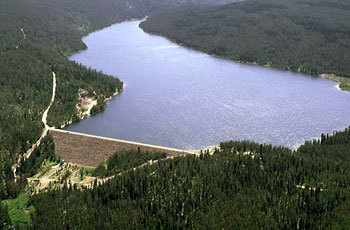
    <summary type="html"><![CDATA[<p><strong><em>The debate between conservation and reclamation postponed the creation of this dam.  The original dam site was going to be off the Yellowstone Lake, but was split into two separate dams.  One, the Grassy Lakes Dam, is the smallest reservoir created by the Minidoka Project.  While is it very close to the Jackson Lake, it is uphill from the other lake and provides water to farmers whose fields are uphill from the other lakes in the area.</em></strong></p><img src="https://www.intermountainhistories.org/files/fullsize/53a68faaadbe553af6085669b614d733.jpg" alt="Grassy Lake Dam" /><br/><p>While this dam is fairly small compared to the nearby Jackson Lake, the creation of this dam was quite dramatic.  In 1919, after working on the Jackson Lake dam, proposals were made for another dam in the Bechler Meadows.  This was an attempt to use the local water for irrigation and farming.  No real action was undertaken for some time, but within a few years, conservationists became alarmed that this dam (along with a few other dam proposals in the area) would recreate the infamous Hetch Hetchy project in Yosemite National Park.  </p><p>In 1919, construction began on the O'Shaughnessy Dam, which created the Hetch Hetchy Reservoir.  This dam was constructed inside a National Park and required special legislation for approval.  The legislation decided that public lands should be used for public benefit and that the scenic valley would be of more use to the community of California as a dam than a place for sightseeing.  By the time of the dam's completion, many groups had already begun calling for the removal and prevention of dams in the name of conservation, the idea that the natural landscape should be preserved.  The Grassy Lake dam fell victim to the backlash against the flooding of the Hetch Hetchy Valley and was postponed.</p><p>After two decades of political debates, a compromise between local irrigators and conservationists in Congress allowed for the creation of two dams, both added to the Minidoka Project.  The Grassy Lake dam was to be created at the head of Cascade Creek, near the Fall river and close to the southern edge of Yellowstone.  This would prevent Yellowstone Lake from being diverted for irrigation, preserving it for future generations.  It would still allow farmers in the area to have access to water during especially dry seasons.  In 1937, construction began and by 1939, the dam was completed.  It is an earth fill dam and can hold 15,000 acre-feet of water.  It is a little over a mile in length and less than half a mile wide.  Recently, in both 1996 and 2004, the Reclamation Bureau modified and replaced some worn out sections of the dam. </p><p><em><strong><a href="https://www.intermountainhistories.org/items/show/78">For more (including 3 images) view the original article</a></strong></em></p>]]></summary>
    <published>2017-08-11T12:06:42+00:00</published>
    <updated>2026-04-17T19:31:59+00:00</updated>
    <link rel="alternate" type="text/html" href="https://www.intermountainhistories.org/items/show/78"/>
    <id>https://www.intermountainhistories.org/items/show/78</id>
    <author>
      <name>Josh Franzen, Brigham Young University</name>
    </author>
  </entry>
</feed>