<?xml version="1.0" encoding="UTF-8"?>
<feed xmlns="http://www.w3.org/2005/Atom">
  <title type="text">Intermountain Histories</title>
  <updated>2026-04-17T19:32:11+00:00</updated>
  <generator uri="http://framework.zend.com" version="1.12.20">Zend_Feed_Writer</generator>
  <link rel="alternate" type="text/html" href="https://www.intermountainhistories.org/"/>
  <link rel="self" type="application/atom+xml" href="https://www.intermountainhistories.org/items/browse?output=rss2"/>
  <id>https://www.intermountainhistories.org/</id>
  <author>
    <name>Intermountain Histories</name>
    <uri>https://www.intermountainhistories.org</uri>
  </author>
  <link rel="hub" href="https://pubsubhubbub.appspot.com/"/>
  <entry>
    <title type="html"><![CDATA[Dark Sky over Arches National Park]]></title>
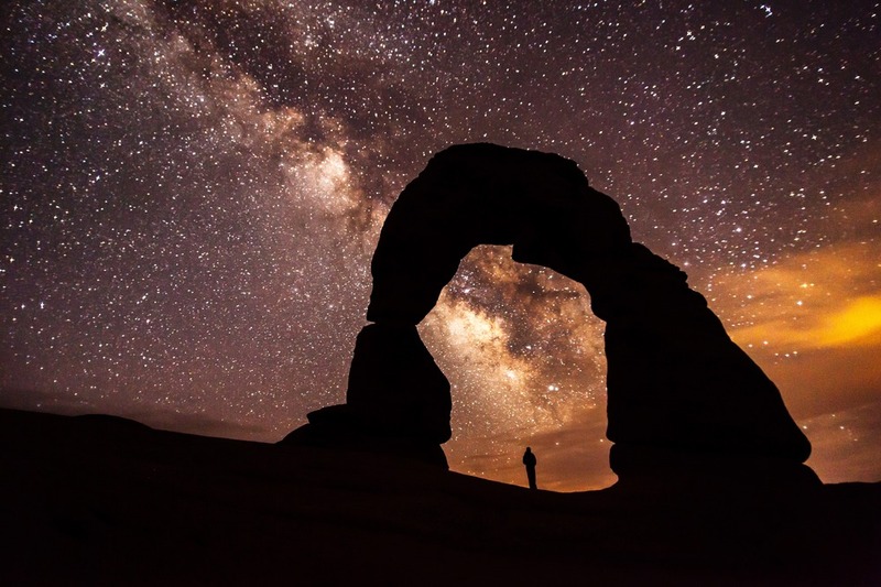
    <summary type="html"><![CDATA[<p><strong><em>Home to over 2,000 natural sandstone arches in Utah, Arches National Park applied for recognition from the International Dark-Sky Association and received the association’s “Silver Tier” designation in 2019 thanks to its commitment to preserving the natural sky and educating the public about the benefits of reducing light pollution.</em></strong></p><img src="https://www.intermountainhistories.org/files/fullsize/94128d7b834b011c0b21f969610c1bc6.jpg" alt="Milky Way over Arches" /><br/><p>First designated a national monument in 1929, Congress declared Arches a national park on November 12, 1971. Arches National Park is one of the “Mighty 5” national parks of Utah, and in 2019, the International Dark-Sky Associated recognized the park’s work toward reducing light pollution within and outside of the park with its Silver Tier designation. (The Silver Tier is given when light glow is present along the horizon to a degree that wildlife and astronomy are impacted, but the Milky Way Galaxy can still be seen in summer and winter with over six thousand stars visible to the naked eye.)
In 1999, a study of 376 parks discovered that half of all National Parks, 189 in total, were threatened by light pollution from encroaching cities. The National Park Service responded by forming the Night Sky Team to document the negative effects of light pollution with 104 photos taken in a short duration. Every photo was stitched together to form a wider picture, and then the Night Sky Team erased the light generated by stars to focus on how artificial lighting impacted the park. Arches National Park in 2003 had significant light pollution from Moab, Utah, and Grand Junction, Colorado, so the park created outdoor lighting codes with training workshops to reduce light pollution, intending to keep visitors safe while minimizing harm to wildlife.
Arches National Park’s lighting codes implement several strategies for reducing light pollution and preserving a clear night sky as a culture heritage. First, Arches’ lights use motion sensors to provide visitors with light when they need it without leaving any running constantly. Second, Arches’ outdoor light fixtures are shielded with hoods and point toward the ground. Third, Arches National Park uses warm-colored light, as blue-colored light negatively impacts insects while amber lighting minimizes sky brightness while still providing visibility to guests. Fourth, Arches encourages nearby cities and households to plan outdoor lighting efficiently and use high quality lights. This includes striving to minimize nighttime lighting and only using what is strictly necessary for public safety.  Close to 100% of all exterior lights throughout the 119-square-mile park are night-sky friendly in accordance with Arches’ principles.
The value Arches National Park places on its dark skies is not limited to lighting codes and stargazing within the park. Educational outreach programs have been created, like the Night Sky Ranger booklet that teaches children about astronomy and light pollution through stargazing and moon phase observation activities. Preservation can maintain the dark skies, but education about the value of dark skies is what will break through the night blindness created by brightly lit societies.</p><p><em><strong><a href="https://www.intermountainhistories.org/items/show/541">For more (including 5 images) view the original article</a></strong></em></p>]]></summary>
    <published>2021-11-14T03:31:12+00:00</published>
    <updated>2026-04-17T19:32:11+00:00</updated>
    <link rel="alternate" type="text/html" href="https://www.intermountainhistories.org/items/show/541"/>
    <id>https://www.intermountainhistories.org/items/show/541</id>
    <author>
      <name>Emma Svenson, Northern Arizona University</name>
    </author>
  </entry>
  <entry>
    <title type="html"><![CDATA[Backcountry Airport: Taylor Wilderness Research Station Airstrip<br />
]]></title>
    <summary type="html"><![CDATA[<p><strong><em>The Taylor Wilderness Research Station airstrip is one of small number of airstrips located in land designated as wilderness in the United States. Constructed by former owner Jess Taylor, the airstrip is now owned by the University of Idaho.</p></strong></p><img src="https://www.intermountainhistories.org/files/fullsize/89980a54b341267ccbe712c0c80dfe73.jpg" alt="TWRS airstrip from its northern side looking west" /><br/><p>The Taylor Wilderness Research Station airstrip is located in the heart of the Frank Church-River of No Return Wilderness in Idaho. Resting on the south bank of Big Creek at the base of a steep valley flanked by cloud-shrouded peaks, the airstrip is approximately one-half mile of grass running between Rush Creek and Pioneer Creek with a small bend in the middle known as a “dog leg.” This airstrip is one of a small handful located in the Frank Church Wilderness.</p><p>Jess and Dorothy Taylor owned and operated a hunting outfit from the ranch before the University of Idaho purchased the property in 1969. Taylor began constructing the Taylor Ranch airstrip May 1948. “Most people don’t realize the amount of work that went into building the airstrip,” Taylor stated in a 1974 interview. The tract of land was once “solid timber and brush.” In an oral history, Taylor stated that when he conceived of building an airstrip he had “no particular instruction on building it.” Construction began with clearing thick brush, followed by the trees. Taylor used dynamite or a team of 1800-pound geldings to remove the remaining stumps. Taylor finished preparing the airstrip using a flip scraper and walking plow. The entire construction of the airstrip took approximately one year. </p><p>The Taylors decided to build an airstrip to bring in customers for the hunting outfit which they planned to operate on the property. When they purchased the property in 1935 air travel was not practical. When the couple moved to Taylor Ranch to live year-round in 1948, backcountry air travel had become feasible. While running the hunting outfit from the property (as had the previous owner, David Lewis), the couple realized that if they were able to develop an airstrip then they could improve their business. Their property was located in prime hunting country, with many opportunities to hunt bighorn sheep, elk, and deer. The addition of the airstrip made the ranch more accessible, turning it into an even more attractive hunting destination.</p><p>Taylor Ranch sat deep within the Idaho Primitive Area, which eventually became part of the Frank Church-River of No Return Wilderness in 1980. The Wilderness Act of 1964 provided for the use of aircraft in designated wilderness areas where aircraft use had been previously established, subject to regulation by the Secretary of Agriculture. This provision has become a point of contention among wilderness activists. The Central Idaho Wilderness Act, which designated the River of No Return Wilderness, also permitted motorized use and access “where previously established.” The Taylor airstrip, established before the passing of these acts, was covered by these provisions. Today, the airstrip is classified as private, meaning that a pilot must receive permission to land at the site. The University of Idaho’s College of Natural Resources owns the ranch, now known as the Taylor Wilderness Research Station (TWRS), and permits the landing of TWRS users and authorized guests who are transported by local aviation companies. Backpackers, hunters, and other recreationists may fly out of TWRS only in the case of a medical emergency. The Taylor Wilderness Research Station airstrip has had many uses throughout its history. Originally built to offer hunting access for the Taylor hunting outfit, the airstrip is now primarily used by students, professors, and field scientists.</p><p><em><strong><a href="https://www.intermountainhistories.org/items/show/304">For more (including 3 images) view the original article</a></strong></em></p>]]></summary>
    <published>2019-02-15T00:53:10+00:00</published>
    <updated>2026-04-17T19:32:05+00:00</updated>
    <link rel="alternate" type="text/html" href="https://www.intermountainhistories.org/items/show/304"/>
    <id>https://www.intermountainhistories.org/items/show/304</id>
    <author>
      <name>Ian C. Pickens, Boise State University</name>
    </author>
  </entry>
</feed>
