<?xml version="1.0" encoding="UTF-8"?>
<feed xmlns="http://www.w3.org/2005/Atom">
  <title type="text">Intermountain Histories</title>
  <updated>2026-04-17T19:32:14+00:00</updated>
  <generator uri="http://framework.zend.com" version="1.12.20">Zend_Feed_Writer</generator>
  <link rel="alternate" type="text/html" href="https://www.intermountainhistories.org/"/>
  <link rel="self" type="application/atom+xml" href="https://www.intermountainhistories.org/items/browse?output=rss2"/>
  <id>https://www.intermountainhistories.org/</id>
  <author>
    <name>Intermountain Histories</name>
    <uri>https://www.intermountainhistories.org</uri>
  </author>
  <link rel="hub" href="https://pubsubhubbub.appspot.com/"/>
  <entry>
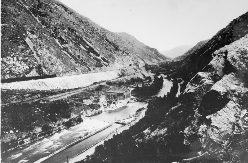
    <title type="html"><![CDATA[Devil&#039;s Gate: Weber Hydroelectric Power Plant, Weber Canyon]]></title>
    <summary type="html"><![CDATA[<p><strong><em>The Weber Hydroelectric power plant has been in operation in 1910. Despite decreased usage, the plant continues to provide power to the local grid. </em></strong></p><img src="https://www.intermountainhistories.org/files/fullsize/ebb83febf330b3a1b119d21aecc11fe7.jpg" alt="Devil&#039;s Gate " /><br/><p><span style="font-weight:400;">Devil’s Gate-Weber Hydroelectric Power Plant is located in Weber Canyon. The power station was completed in 1910 on the Weber River. Crowded between steep, winding canyon walls alongside the Union Pacific Railroad and Interstate 84, the plant has stood for over 100 years.</p><span style="font-weight:400;">The conservation movement at the turn of the century was a scientific movement focused on rational planning to increase efficient use of all natural resources. Dams were a solution to making water usage more efficient. Dams conserve water for agriculture and municipal needs as well as provide flood control and electricity. This was the Progressive Era’s ideal approach to managing water resources. Ogden and Salt Lake City were rapidly industrializing at the end of the 1800s with the construction of railroads and and better public transportation. However, an efficient power grid was needed to maintain these advances. Thus, Devil’s Gate was a vital component to support a well-organized system for Ogden and Salt Lake City. </span>
<span style="font-weight:400;">During construction, a conflict with the Union Pacific Railroad almost prevented Devil’s Gate from being built. C. K. Bannister, an engineer involved in the construction of the Pioneer hydroelectric plant in Ogden Canyon, began work on Devil’s Gate in 1900. However, with the railroad next to the Weber River, Union Pacific Railroad officials were concerned a dam would damage the railbed and temporarily halted the dam's progress. Bannister died before work resumed, and his associates, Thomas D. Dee and David Eccles, sold the property rights to the Utah Light and Railway Company. Around the same time, the president of the Union Pacific Railroad, Edward Henry Harriman, purchased sixty-percent of Utah Light and Railway Company’s stocks, thus gaining majority control of the firm. Harriman intended to upgrade the Northern Wasatch Front’s electrical output to make it efficient for his electric streetcar operation in Salt Lake City. Unable to acquire more water rights in Ogden Canyon to improve the Pioneer plant, Harriman authorized the construction of Devil’s Gate with the stipulation that precautions be taken to protect the railroad embankment from potential erosion. Construction on the dam was completed two years later. </span>
<span style="font-weight:400;">With the rapid urbanization of the Wasatch Front at the end of the 1800s, several small power companies sprung up, creating intense competition. This led to corporate consolidations and larger power grids. Devil’s Gate was completed in 1910 and was one of the first power plants in Utah intended to feed an electrical grid. Previously, power plants adjusted their output based on the local daily or seasonal needs, but Devil’s Gate would run continuously at full capacity to meet the needs of the overall system powering all of Salt Lake City and Ogden, including Salt Lake City’s electric streetcars. In 1914, ownership of Devil’s Gate passed into the private hands of Utah Light and Traction, who lost all of its power stations to the Utah Power and Light Company in 1915. </span>
<span style="font-weight:400;">Under the ownership of the Utah Power and Light Company, several modifications were made to Devil’s Gate to increase its electrical capacity and efficiency. In 1989 it was placed on the National Register of Historic Places. It still functions within a power grid today, but its role is far smaller due to the construction of larger dams which surpass Devil’s Gate electrical output. </span></p><p><em><strong><a href="https://www.intermountainhistories.org/items/show/665">For more (including 4 images) view the original article</a></strong></em></p>]]></summary>
    <published>2022-10-12T18:55:36+00:00</published>
    <updated>2026-04-17T19:32:14+00:00</updated>
    <link rel="alternate" type="text/html" href="https://www.intermountainhistories.org/items/show/665"/>
    <id>https://www.intermountainhistories.org/items/show/665</id>
    <author>
      <name>Amber Bell, Weber State University</name>
    </author>
  </entry>
  <entry>
    <title type="html"><![CDATA[Devil&#039;s Slide]]></title>
    <summary type="html"><![CDATA[<p><strong><em>Not far from the border between Utah and Wyoming is a compelling natural landmark: Devil's Slide. This landmark was so famous, a company used Devil's Slide as its logo.</em></strong></p><img src="https://www.intermountainhistories.org/files/fullsize/db1dccb467cf45e10122cdb981c728f3.jpg" alt="The Devil&#039;s Slide, Utah 1873" /><br/><p><span style="font-weight:400;">Devil’s Slide rock formation is nestled on the side of the steep Wasatch mountain range, hovering over Interstate 84. It has a height of 40 feet, and the length of the formation runs vertically hundreds of feet down a mountain. There is also an in-between space, the slide, which is about 25 feet in open space between the two vertical limestone rock slides.</span>
<span style="font-weight:400;">It is presumed that the name of the formation was given by a railroad worker named James John Walker, whose family was  one of the first to live in Croydon. According to the family history of Walker, James John was working on railway tracks in the region, likely in 1868, when some of his colleagues asked him to give a name to the strange rocky chute–his answer was Devil’s Slide.</span>
<span style="font-weight:400;">This region is rich in limestone resources, and, in 1904, </span><span style="font-weight:400;">the Union Portland Cement Company was founded by several prominent Utah citizens: Reed Smoot, M.S. Browning, Joseph Scowcroft, and James Pingree.  A company town soon sprang-up a couple hundred yards downstream from the plant site. The town was named Devil’s Slide after the nearby rock formation. </span><span style="font-weight:400;">The original plant supplied materials to most of Utah’s construction industry. After World War II, a second plant on the site replaced the original facility. </span>
<span style="font-weight:400;">At its height, the population of Devil’s Slide exceeded 250 people. As was typical with mining towns at the time, many of the workers were foreign born. Most of them cam from Italy, Austria, Greece, and Japan. Many of the these migrant workers lived in the local hotel, the largest structure in the town. This two-story building contained twenty bedrooms on the second level with each room accommodating two men to each room. Other notable buildings located in the town were the combination drug store/post office, railroad depot, mercantile, two schoolhouses, and a company clubhouse. The company laid cement sidewalks, built a baseball diamond, and planted one hundred trees throughout the village.</span>
<span style="font-weight:400;">By the mid-1980s, only a handful of families remained. By the end of the decade, the company decided to close the village altogether. All the families had moved on with the exception of the railroad section foreman who lived in a house owned by the railroad. The railroad demolished this house not long after the town was emptied.</span></p><p><em><strong><a href="https://www.intermountainhistories.org/items/show/365">For more (including 3 images) view the original article</a></strong></em></p>]]></summary>
    <published>2019-10-10T22:48:52+00:00</published>
    <updated>2026-04-17T19:32:07+00:00</updated>
    <link rel="alternate" type="text/html" href="https://www.intermountainhistories.org/items/show/365"/>
    <id>https://www.intermountainhistories.org/items/show/365</id>
    <author>
      <name>Jesse Wayment, Weber State University</name>
    </author>
  </entry>
</feed>
