<?xml version="1.0" encoding="UTF-8"?>
<feed xmlns="http://www.w3.org/2005/Atom">
  <title type="text">Intermountain Histories</title>
  <updated>2026-06-16T14:34:55+00:00</updated>
  <generator uri="http://framework.zend.com" version="1.12.20">Zend_Feed_Writer</generator>
  <link rel="alternate" type="text/html" href="https://www.intermountainhistories.org/"/>
  <link rel="self" type="application/atom+xml" href="https://www.intermountainhistories.org/items/browse?output=rss2"/>
  <id>https://www.intermountainhistories.org/</id>
  <author>
    <name>Intermountain Histories</name>
    <uri>https://www.intermountainhistories.org</uri>
  </author>
  <link rel="hub" href="https://pubsubhubbub.appspot.com/"/>
  <entry>
    <title type="html"><![CDATA[Stibnite Mine: Dormant but Not Dead]]></title>
    <summary type="html"><![CDATA[<p><strong><em>Nestled up in the mountains above Valley County, Idaho, in the Payette National Forest, beyond even the most remote town in the region, and in the middle of an otherwise densely green forest, sits Stibnite the currently dormant Stibnite Mine: a landscape of stripped earth, dead grass, rock, and the infamous “Glory Hole,” an open pit with a sluggish pond of waste. </em></strong></p><img src="https://www.intermountainhistories.org/files/fullsize/20dc0bda7b67c07ecd976075edfdf300.jpg" alt="Glory ole" /><br/><p>The Stibnite Mine, located in what is now the Payette National Forest, started during the 1899 Thunder Mountain gold rush. The first known claims were staked by Albert Hennesy in 1914. Those were later purchased by the United Mercury Mining Company of Boise and optioned by the San Francisco-based Bradley Mining Company in 1927 for mining and milling gold. Stibnite’s most active period of operation came during World War II. A core sample taken from the site revealed an abundance of tungsten and high-grade antimony, materials crucial to the war effort for supplying reinforced armor, ammunition shells, fire resistant clothing, and electrical chips. Between 1941 and 1945, Stibnite miners provided 90% and 40$ of the nation's domestic supply of antimony and tungsten, respectively. 
To extract so much material, Bradley Mining expanded Stibnite into a much larger beast. Instead of digging mine shafts, Bradley initiated open pit mining. To process the raw material, the company installed heavier equipment, such as a smelter and mill. When WWII ended, the demand for antimony and tungsten dwindled, and Stibnite’s profits with it. From this point forward, Stibnite operated off and on throughout the years, passing through different companies several times until it completely shut down in 1997.
The end of active mining didn’t end Stibnite’s story, though; instead, environmental issues took front and center stage. After years of mining, Stibnite had accumulated a massive amount of waste, raising the problem of what to do with it. One major point of contamination came from the Bradley Tailing Pile Dump in the Meadow Creek Floodplain. Preventing massive amounts of mine waste from washing downriver into the valley required diverting Meadow Creek twice. Even after this intervention, an environment and water quality survey conducted periodically from 2011 to 2017 around the Stibnite–Yellow Pine area, which included Meadow Creek, revealed elevated levels of mercury, antimony, and arsenic contamination.
In addition to efforts to minimize the effect of tailings leeching contaminants into the waterways below the site, there have also been efforts to clean up and restore the environmental quality of Stibnite itself. For example, high school students conducted a multi-year tree planting project. Alongside these restoration and monitoring efforts have also been proposals to reevaluate the area’s continued resource potential by Perpetua Resources, the company now in charge of the Stibnite site. As of now, there has been an ongoing bid to reopen the Stibnite area mining once again—gold this time—bringing Stibnite’s mining story up to the present but not necessarily to its end.</p><p><em><strong><a href="https://www.intermountainhistories.org/items/show/625">For more (including 3 images) view the original article</a></strong></em></p>]]></summary>
    <published>2022-06-26T01:59:56+00:00</published>
    <updated>2026-06-16T14:34:55+00:00</updated>
    <link rel="alternate" type="text/html" href="https://www.intermountainhistories.org/items/show/625"/>
    <id>https://www.intermountainhistories.org/items/show/625</id>
    <author>
      <name>Meghan Laughlin, College of Idaho</name>
    </author>
  </entry>
  <entry>
    <title type="html"><![CDATA[Idaho Springs’ Argo Mill &amp; Tunnel]]></title>
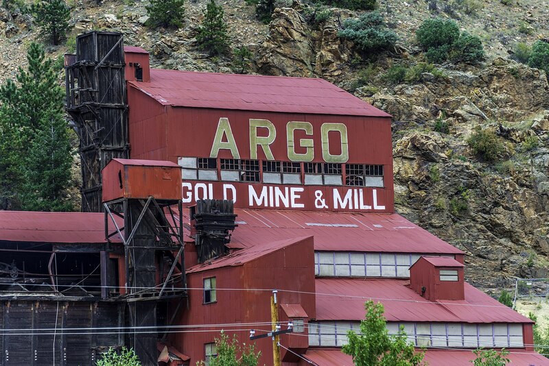
    <summary type="html"><![CDATA[<p><strong><em>The Argo Tunnel and Mill serves as a reminder of Central City and Idaho Springs’ importance in the Colorado Gold Rush, and it is part of the historic preservation efforts of the Idaho Springs, Black Hawk, and Central City areas. </em></strong></p><img src="https://www.intermountainhistories.org/files/fullsize/eaa667bf498f4f3a7ddeb6f5cb1c2c44.jpg" alt="Argo Mill" /><br/><p>In January of 1859, George Andrew Jackson discovered gold in Clear Creek, and John Gregory found gold in the North Fork of the same river on May 6. Jackson’s discovery led to the creation of modern-day Idaho Springs, and out of Gregory’s discovery emerged Central City, Black Hawk, and Nevadaville. Nevadaville has since become a ghost town, but Idaho Springs remains home to approximately 2,000 people. Central City and Black Hawk, although less populated, now primarily serve as gambling towns. The Argo Tunnel, whose construction began in 1891 and finished in 1910, served to connect the two mining areas and provide drainage for the water used in mining operations. At about $5 million dollars to build and just under 22,000 feet long, the Argo Tunnel was the longest tunnel in the world in 1910. The effects of the Argo tunnel are still noticeable in both tourism and the efforts to clean up the Clear Creek area.
Mining took place in Idaho Springs from 1859 to the early-1940s, when gold mining halted due to World War II. Meanwhile, the Central City–Black Hawk area quickly lost mining importance in the 1880s, and in 1918 the area stopped producing gold, pivoting to emphasize tourism through the Central City Opera House. However, by the 1980s, Central City and Black Hawk faced significant structural and health issues. The water had been condemned, and the city could not financially provide upkeep for historic buildings. In response, Colorado voters brought gambling back to the area. Once known as “the richest square mile on earth,” Central City has since taken a backseat to Black Hawk, although both still retain own casino districts. Due to the reintroduction of gambling, Black Hawk and Central City became concerned with cleaning up the pollution from and remnants of mines.
Meanwhile, because of Idaho Springs’ proximity to Interstate 70—convenient for commuting to Denver—the old Argo Mill and Argo Tunnel are visible from the freeway. The tunnel was sealed on January 19, 1943 when an accident flooded the chamber and killed four individuals. In addition to draining water from mines by using a low-grade decline from its origin in Central City to the end point in Idaho Springs, the Argo Tunnel also served to ventilate the mines and provide ore transportation.
In total, the Argo Tunnel processed around three trillion dollars’ worth of gold by today’s standard. Today, visitors can view original mining equipment, the Argo mill itself, and part of the Argo Tunnel. The tunnel is not safe due to the buildup of mining pollution, but removing the pollution is currently part of the EPA superfund site’s goals. Individuals can even experience a glimpse of the lives of Jackson and Gregory as they pan for gold. Overall, the Argo Tunnel serves as a reminder of the environmental damage caused by decades of mining as well as the town histories of Central City, Black Hawk, and Idaho Springs.</p><p><em><strong><a href="https://www.intermountainhistories.org/items/show/487">For more (including 4 images) view the original article</a></strong></em></p>]]></summary>
    <published>2021-09-16T21:20:26+00:00</published>
    <updated>2026-04-17T19:32:10+00:00</updated>
    <link rel="alternate" type="text/html" href="https://www.intermountainhistories.org/items/show/487"/>
    <id>https://www.intermountainhistories.org/items/show/487</id>
    <author>
      <name>Nikki Smith, Brigham Young University</name>
    </author>
  </entry>
  <entry>
    <title type="html"><![CDATA[Oro City: The Beginnings of Leadville]]></title>
    <summary type="html"><![CDATA[<p><strong><em>A once prosperous mining town, Oro City is not just a ghost town left behind by the Colorado gold rush. It is also an environmental hazard.</em></strong></p><img src="https://www.intermountainhistories.org/files/fullsize/128ef543b5fc00e04b72795a7bffb3a1.jpg" alt="Hydraulic mining in California Gulch" /><br/><p><span style="font-weight:400;">In early 1860, prospectors were exploring gulches and panning for gold deep in the Rocky Mountains of Colorado. One prospector, Abe Lee, produced the lucky pan with gold in late April. They named the area California Gulch, supposedly because Abe Lee exclaimed, “I’ve just got California in this here pan!” By summer of the same year, California Gulch’s population had risen from the original party of miners to five thousand individuals, including women. California Gulch was seven miles long and a city grew around it, eventually concentrated toward the northern end of the Gulch. This town came to be known as Oro City and served as the precursor to the modern-day city of Leadville.</span>
<span style="font-weight:400;">Oro City experienced waves of growth and decline as the seasons changed and as gold waned and silver and ore increased. In the beginning, the city had no official government and instead operated using the miners’ code and group meetings.  When Colorado became a territory the next year, Oro City became the county seat of Lake County and elections were held. The city’s population fluctuated seasonally, as winter conditions made mining difficult or impossible. Annual spring thaws repeatedly brought miners back until around 1865. By that point around five million dollars of gold had been extracted from three miles of the gulch, but gold-producing ore was exhausted. The population began to decline thereafter. A stamp mill named “The Printer Boy” was constructed in 1868 and helped partially sustain the local economy, but diminishing ore and continued technological troubles with requisite water pumping hindered business. The Printer Boy soon closed, along with other mills and smelters, and Oro City’s population moved elsewhere.</span>
<span style="font-weight:400;">In 1873 or 1874, a new settlement emerged near Oro City named Slabtown. Slabtown </span><span style="font-weight:400;">later became Leadville when William H. Stevens and Albinus B. Wood began the “Oro Mining Ditch and Fluming Company.” Stevens and Wood bought up large areas in the California Gulch and began producing silver and lead. Mining became concentrated in the Gulch, and the population moved down the mountain.</span>
<span style="font-weight:400;">Today, California Gulch is one of over 200 superfund sites in the state of Colorado, sites the EPA has specifically set aside for environmental recovery. For the most part, the 18 square miles of the superfund site is under control, although young children and expecting mothers should monitor their blood for heavy metals. Although the exposure is under control, the EPA will need to finish construction to seal up mines to create an area that is safe for the public to enter.</span></p><p><em><strong><a href="https://www.intermountainhistories.org/items/show/475">For more (including 3 images) view the original article</a></strong></em></p>]]></summary>
    <published>2021-09-10T23:09:03+00:00</published>
    <updated>2026-04-17T19:32:10+00:00</updated>
    <link rel="alternate" type="text/html" href="https://www.intermountainhistories.org/items/show/475"/>
    <id>https://www.intermountainhistories.org/items/show/475</id>
    <author>
      <name>Nikki Smith, Brigham Young University</name>
    </author>
  </entry>
  <entry>
    <title type="html"><![CDATA[Murray Smelter: The Purpose of the Superfund Program]]></title>
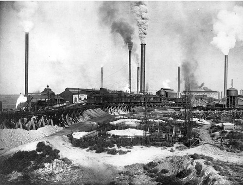
    <summary type="html"><![CDATA[<p><strong><em>State, local, and EPA officials worked together in Murray, Utah - a suburb of Salt Lake City - to clean up a lead smelter that had received the highest ever hazard rating from the EPA. </em></strong></p><img src="https://www.intermountainhistories.org/files/fullsize/f5dd95bbbf8d8a7695a767a59e41168b.jpg" alt="Murray Smelter" /><br/><p>The Murray Smelter Superfund demonstrates the potential of the ambitious Superfund program and stands as a testament to its limitations. Modern industry has had staggering destructive impacts across the West. Clean-up processes have been complicated and often delayed. There are flaws in the Superfund program, but ultimately it was created for a good purpose. It marked an era when Americans started to be conscious of the impacts that they were having on the environment and strove to remediate the damage they had done. </p><p>Opened in 1902 and operated by the American Smelting and Refining Company (ASARCO), the Murray Smelter grew to become the nation’s largest supplier of lead. As early as 1907, nearby farmers began to complain of the effect that lead and arsenic released into the air were having on livestock and crops. A national court case forced ASARCO to invest in new towering smokestacks that would reduce the effects of the pollution. The smelter operated 24 hours a day, seven days a week, superheating lead ore and separating it from other material while also releasing copious amounts of toxic material into the air and water. Following the end of WWII, the demand for lead declined and the Murray Smelter closed in 1949, leaving behind the iconic smokestacks and 142 deserted acres of polluted property. In 1994 when the EPA evaluated the site for consideration on the Superfund list, it received the highest ever hazard rating ever given in agency’s history, at 86.6. By comparison, the average hazard rating for the other Superfund sites in this tour is only 45.3. The hazard rating is used “to assess the relative potential of sites to pose a threat to human health or the environment.” The rating that the Murray Smelter received was alarming, especially when considering the town’s high school was just across the street.</p><p>And yet, the city of Murray refused to be defined by its environmental problem. City, state, and EPA officials immediately began work together on cleanup operations. The smokestacks that were caked in toxic lead and asbestos were demolished in 2000, and thousands of tons of contaminated soil have since been removed. ASARCO has contributed to the cleanup as well, providing funding and installing groundwater monitoring stations. By 2002, the site was deemed clean enough for commercial development, and now is home to a massive Intermountain Healthcare Medical Center, Costco, and the local public transportation Frontrunner station. The EPA’s site manager commented, “The ability to work and problem solve with so many different groups made the cleanup process exciting.” The successful collaboration turned one of the most potentially dangerous toxic sites in America into a thriving commercial area. </p><p>The Murray Smelter site shows the potential that the Superfund program has; however, it also shows that the clean-up process can be highly selective. In the other locations featured in Superfund Me: Stories of Environmental Tragedies in the West, as well as many others across the nation, groups of people are neglected because of the lack of economic opportunities in their cities. The Navajo and the Coeur d’Alene tribes are ignored as the land and water they have relied on for generations is poisoned. The cries for help from the people of Monticello, Silverton, and Libby are discarded because their communities are so small. The immigrant miners of Butte were forced to move as their homes were consumed by a giant pit, and just as the people of Hayden today face economic and environmental pressures that threaten to create a new ghost town. The attention and effort that we give to clean the massive messes we have made should not be based on the economic potential of that area. We should learn from those past mistakes to ensure a healthy relationship between man and the environment in the future. We owe it to everyone and everything that considers the West its home.  </p><p><em><strong><a href="https://www.intermountainhistories.org/items/show/383">For more (including 4 images) view the original article</a></strong></em></p>]]></summary>
    <published>2020-01-08T23:38:49+00:00</published>
    <updated>2026-04-17T19:32:07+00:00</updated>
    <link rel="alternate" type="text/html" href="https://www.intermountainhistories.org/items/show/383"/>
    <id>https://www.intermountainhistories.org/items/show/383</id>
    <author>
      <name>Sam Heywood, Brigham Young University</name>
    </author>
  </entry>
  <entry>
    <title type="html"><![CDATA[Run Like Hell: The Libby Asbestos Story	]]></title>
    <summary type="html"><![CDATA[<p><strong><em>In 2009, the EPA declared the situation in Libby, Montana a public health emergency due to residents' levels of exposure to asbestos from nearby mines.  </em></strong></p><img src="https://www.intermountainhistories.org/files/fullsize/bb2ee5fd316ff1cffbb7fa0dbb243e89.jpg" alt="Zonolite Insulation Advertisement" /><br/><p>In 1999 the EPA began to investigate claims that an alarming number of residents of Libby, Montana were experiencing health problems from exposure to asbestos. This was linked to nearby mines and Libby was placed on the superfund list in 2002. In 2009 the EPA declared the situation in Libby a “Public Health Emergency” - a first in the agency’s history - citing the immediate need for additional funding from the national government. Over 400 people have died in this small mountain town due to an asbestos contamination, and an estimated 3,000 additional people have been diagnosed with diseases such as mesothelioma. </p><p>The Zonolite company first started mining operations in Libby in the 1920s, extracting the mineral vermiculite from the surrounding mountains. Vermiculite is a unique mineral that expands when exposed to heat and is used for a variety of purposes. Zonolite marketed vermiculite as the cheapest, most efficient way to insulate homes and experienced great success initially. During its operation, the mine in Libby was responsible for providing 80% of the country’s vermiculite supply and was successfully marketed to homeowners across America.  Pure vermiculite is not dangerous, but unfortunately for the townspeople of Libby, the nearby deposit was contaminated by a naturally occurring form of asbestos called tremolite-actinolite.</p><p>By 1956 it was clear that Zonolite knew about the asbestos risk, but they did not disclose it to their employees. In 1963 when W. R. Grace and Company bought the mine in Libby, the effects of the asbestos were readily apparent in miners. A company report from 1965 contained a long list of employees that are listed as having “abnormal chests,” many of whom had already died from lung disease. People in the town were certainly aware that the large quantity of dust was linked to rising number of health problems, but when they asked about the mysterious “dust disease,” company officials always responded that the mine only contained tremolite. One miner remembered confronting a mining operator upon learning that tremolite is one of the most dangerous forms of asbestos. “That really upset me because we’re not geologists. There’s not a person up on that hill that new the definition for tremolite.”</p><p>The dust affected the entire community, not just the employees. When miners returned home from work, they were covered in toxic dust. Embraces with loved ones were unknowingly dangerous for their families. Waste and dust from the mines contaminated over one million cubic yards of soil, land on which schools and playgrounds were built. Surrounding groundwater was contaminated as well, carrying deadly fibers of asbestos into the intestines of the people of Libby. By the time the mine closed in 1990, it was too little too late for many of the town’s residents. Asbestos from the mine devastated Libby, killing up to 10% of the population, and afflicting many more. </p><p>W. R. Grace executives were acquitted in a trail brought against them by the federal government for knowingly causing harm to the people of Libby, in which the CEO stated "the company worked hard to keep the operations in compliance with the laws and standards of the day." The judge who presided in the case took issue with the prosecution’s “inexcusable dereliction of duty” in the handling of some evidence, and ultimately could not convict a company responsible for violating a law (the Clean Air Act) that was not in effect during the mine’s operation. Locals of Libby were disappointed in the verdict, but many admit that the company was not entirely to blame for the mine staying open for so long. Zonolite and Grace provided jobs for these people and are responsible in large part for the existence and identity of the town. One miner summed up the precarious situation like this, “I loved my job at Zonolite. I loved it so much that even if they had told me that I was endangering my life, I would probably have stayed. But if they’d told me it was killing my wife and my family too, I would have run like hell.” </p><p>The EPA initially divided Libby into zones for the cleanup operation. Today, certain zones have been deemed “clean,” while other, more isolated areas still report contamination. People in Libby still gather every year to remember the loved ones they have lost to disease. Some still demand compensation from the government, but the Superfund program is unable to offer any financial assistance to affected residents. By law, the EPA can only divert funds to cleanup operations. Others want to move on from the disaster, and look forward to a future where their small town is not defined by the asbestos tragedy.  </p><p><em><strong><a href="https://www.intermountainhistories.org/items/show/382">For more (including 7 images) view the original article</a></strong></em></p>]]></summary>
    <published>2020-01-08T23:23:55+00:00</published>
    <updated>2026-04-17T19:32:07+00:00</updated>
    <link rel="alternate" type="text/html" href="https://www.intermountainhistories.org/items/show/382"/>
    <id>https://www.intermountainhistories.org/items/show/382</id>
    <author>
      <name>Sam Heywood, Brigham Young University</name>
    </author>
  </entry>
  <entry>
    <title type="html"><![CDATA[Becoming a Ghost Town: The Superfund of Hayden, Arizona]]></title>
    <summary type="html"><![CDATA[<p><strong><em>Hayden, Arizona faces depopulation and pollution due to the nearby copper smelter that provided most of the town's jobs over the last century. </em></strong></p><img src="https://www.intermountainhistories.org/files/fullsize/3e32f171ae34e5252cf0c9c3ca0fcd9c.jpg" alt="Hayden Smelter" /><br/><p>Unlike scenic towns in Colorado and Idaho, Hayden, Arizona has been unable to shift its economic focus to tourism. According to one article, it lacks “charm” and is too polluted to attract visitors. Today Hayden’s very existence is threatened by depopulation: it has lost 75% of its people since 1920. Residents worry that if things don’t change soon, Hayden could be abandoned entirely. Like other cities in this tour, Hayden was built as a company town in the early 20th century close to the nearby source of jobs: a copper smelter. Kennecott built the smelter and operated the nearby mine that supplied the ore, but eventually both were bought by the Arizona-based mining company ASARCO in 1986. The smelter in Hayden has released a staggering amount of toxic metals into the air throughout the years and is responsible for adverse health effects on the townspeople.</p><p>Pollution and the health problems that come from it have divided the town. Some demand justice for ASARCO’s disregard for health and the environment, while others defend the company’s economic value in Hayden. There are key differences in Hayden though. For one, the smelter is still in operation today, and the threat of air pollution is still relevant. Another important distinction in Hayden is that the town isn’t technically on the National Priority List for Superfund sites. Instead, it has been classified as a Superfund alternative approach, which according to the EPA, “uses the same investigation and cleanup process and standards that are used for all Superfund sites.” Basically, when a potentially responsible party, in this case ASARCO, presents a plan for cleanup that the EPA deems acceptable, they allow the private company to handle operations with state and national oversight. Due to copper’s importance to the state’s economy, the state of Arizona worked hard to ensure Hayden avoided the stigma of being officially listed as a Superfund. However, no one worked harder than ASARCO to avoid the designation.</p><p>Over the years they have maintained that pollution is well under dangerous levels, even in the face of serious litigation brought on by fed-up Hayden residents in 2008. Reforms include installing new equipment with emission-reducing technology and covering contaminated soil. However, residents complained that the thin layer of gravel laid down by ASARCO isn’t enough to mitigate the danger, especially when it rains, and the contaminated soil escapes from underneath. </p><p>In 2011 the EPA officially sanctioned ASARCO for violating the Clean Air Act by having as much as two to three times the federal limit of lead emissions on some days, but cleanup was still left to the company. With budget cuts to the EPA and the current administration’s general views towards the environment, it is uncertain if federal aid for the cleanup will ever arrive in Hayden. Many have left as evidenced by the boarded-up buildings that line Main Street, but some claim to be too poor to relocate. Even the 10,000 dollars that residents won in the lawsuit against ASARCO is not enough to help people escape. For some, it feels as if they are trapped watching Hayden become a ghost town. </p><p><em><strong><a href="https://www.intermountainhistories.org/items/show/381">For more (including 3 images) view the original article</a></strong></em></p>]]></summary>
    <published>2020-01-08T23:11:54+00:00</published>
    <updated>2026-04-17T19:32:07+00:00</updated>
    <link rel="alternate" type="text/html" href="https://www.intermountainhistories.org/items/show/381"/>
    <id>https://www.intermountainhistories.org/items/show/381</id>
    <author>
      <name>Sam Heywood, Brigham Young University</name>
    </author>
  </entry>
  <entry>
    <title type="html"><![CDATA[The Gold King Mine Disaster: EPA’s “Help” Not Wanted ]]></title>
    <summary type="html"><![CDATA[<p><strong><em>After an accidental spill at Gold King Mine in 2015, Silverton residents resisted Superfund designation fearing it would negatively impact tourism in the area. </em></strong></p><img src="https://www.intermountainhistories.org/files/fullsize/a7c08f5be62c192ef0eaf31a5c578cb2.jpg" alt="Gold King Mine" /><br/><p>In 2015, the EPA hired private contractors to clear the entrance to the abandoned Gold King Mine outside of Silverton, Colorado. They sought to determine the mine’s impact on contamination of the nearby Animas River. There had been a steady trickle of highly acidic waste coming from the mine since its closure in 1991, but the workers were not expecting to find 3 million gallons of highly pressurized orange sludge waiting on the other side of a massive plug in the mine. Those present were fortunate to escape with their lives as the poisonous mixture flowed down the mountain, eventually draining into the Animas River. The river turned a murky orange and immediately a ban was placed on drinking or swimming in the water due to the high amounts of toxic lead and arsenic. Exactly one year after the disaster, the EPA placed the region surrounding Silverton on the superfund list, qualifying it for federal funding for clean-up efforts. Silverton had actually been fighting Superfund designation for over 20 years. Residents feared it would impact the region’s primary economic market - tourism.</p><p>Silverton has a history of defending itself. Concern over pollution was a century-old affair, but the people of Silverton vehemently defended their principal sources of income: mining and processing raw ore. In the early 20th century, residents of the downstream town of Durango were fed up with Silverton’s pollution. In 1902, the Durango Democrat complained, “There never was a word or sentence uttered against the purity and excellence of the Animas river water until Silverton, in open violation of the law, began using the stream for a dumping ground for garbage and mill tailings.” The Silverton Standard shot back, “The thing for Durango to do is employ its energy in providing a water supply from some of the many pure mountain streams[…] It certainly cannot afford to take any action that will annoy or embarrass the mining and milling of Silverton.” However, Silverton was also well accustomed to the economic booms and busts associated with mining. In response, the city had turned to tourism as early as the 1930s. The Animas River provided adventurous river rafting experiences, and the surrounding San Juan Mountains left visitors awestruck. When the last mines closed in the 1990s, tourism was the largest industry left in Silverton. </p><p>With the same passion that residents once defended their mines, they defended their reputation as a scenic mountain paradise. One lifelong Silverton resident remarked, “We’re a tourist area. You hear the word ‘Superfund’ site and 99 percent think ‘danger.’ So why would you want to go to a Superfund site?” It is not as though the people of Silverton are pro-pollution, for there is an organized community effort to clean up the Animas, but rather they are understandably committed to protecting what brings business into their town. Some residents blame the EPA for the leak, while others fault the Gold King Mine Company for the pollution in the first place; however, everyone in Silverton can agree that the EPA’s Superfund program is not welcome relief from environmental tragedy, but a death sentence on the town’s marketability as a popular destination. </p><p>The Animas River was deemed safe for drinking and recreational use weeks after the spill, though there are still consequences from the disaster. Today the EPA continues clean-up operations near Silverton and the site has grown to include 48 mines that risk contaminating groundwater. A water treatment plant was constructed in 2015, though according to the EPA, “migration of contaminated groundwater is not stabilized.” The impact of human exposure to the toxic waste is uncertain, but contaminated waste reached as far as New Mexico, Utah and the Navajo Nation, harming crops and livestock near the Animas and San Juan Rivers. Despite their initial misgivings towards the EPA and the Superfund program, the people of Silverton now work together with the federal government to clean-up the last mess and assure this never happens again. </p><p><em><strong><a href="https://www.intermountainhistories.org/items/show/380">For more (including 5 images) view the original article</a></strong></em></p>]]></summary>
    <published>2020-01-08T22:28:45+00:00</published>
    <updated>2026-04-17T19:32:07+00:00</updated>
    <link rel="alternate" type="text/html" href="https://www.intermountainhistories.org/items/show/380"/>
    <id>https://www.intermountainhistories.org/items/show/380</id>
    <author>
      <name>Sam Heywood, Brigham Young University</name>
    </author>
  </entry>
  <entry>
    <title type="html"><![CDATA[Tragedy at Church Rock: Superfunds and the Marginalization of Navajos]]></title>
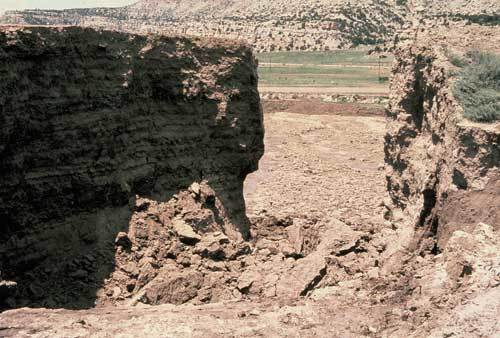
    <summary type="html"><![CDATA[<p><strong><em>In 1979 the United Nuclear dam in New Mexico failed and released over 1,000 tons of radioactive waste, greatly harming the Navajo community at nearby Church Rock. </em></strong></p><img src="https://www.intermountainhistories.org/files/fullsize/24fb43a1f523a53719f4159e884c1d1d.jpg" alt="Church Rock Dam Breach" /><br/><p>Before sunrise on July 16, 1979, Navajos who resided in Church Rock, New Mexico, awoke to the sound of rushing water. They were confused, for there had been no rain to cause flooding of the nearby Puerco River. Unbeknownst to them, a nearby dam owned by United Nuclear had failed, releasing 95 million gallons of mine waste into the local water systems. This waste contained 1,100 tons of radioactive waste from a mill that processed uranium, killing sheep that drank it and burning the feet of children who waded in it. United Nuclear temporarily closed the mill and immediately the Indian Health Services urged people not to drink the water, but without assistance many poor families had no other options. Shortly after, the CDC tested the radiation levels of just six people, and when their results weren’t alarming, declared that no major threat to public health existed due to the spill. In spite of this, the Navajo Nation appealed to the state’s governor to declare a state of emergency in the Church Rock area, a request that was denied. However, when United Nuclear threatened to start laying people off if the mill remained closed, the state and federal government quickly complied to let mill operations resume just five months after the massive spill. The spill, and effects from the mill’s continued operation after, landed the Church Rock on the National Priority List for Superfund sites in 1983.</p><p>The neglect of Navajo lands is evident when one compares the response to another nuclear accident that happened just four months prior at Three Mile Island in Pennsylvania. A partial nuclear meltdown led to the evacuation of 140,000 people and to the state declaring a state of emergency, even though the release of nuclear radiation was significantly less than at Church Rock. Many government funded investigations were commissioned to understand the causes and the long-lasting effects of the accident in Pennsylvania, but such studies do not exist for the Navajo at Church Rock. The failure of United Nuclear’s dam was no mystery; cracks were reported in the 75-foot earthen structure nearly two years prior to the spill, but no action was taken. United Nuclear efforts to clean amounted to the removal of 3,500 tons of contaminated soil downstream, estimated to be just 1% of the total affected soil.</p><p>The site’s designation as a Superfund has hardly been effective at providing meaningful assistance. After 36 years as a Superfund, the EPA’s website still reports today that “groundwater contamination, and the migration of contaminated groundwater is not stabilized.” Many Navajos have long given up hope of government assistance. They have formed grassroots organizations like Eastern Navajo Diné Against Uranium Mining to prevent future mining operations and aid contaminated areas. In 2017, the ENDAUM discovered a small Navajo community was still using contaminated water to hydrate and bathe their livestock. They found hairless sheep and insides of cows that had turned yellow. The Navajo had to burn the sick animals to avoid further contamination. Even though there is a lack of scholarly investigation on the effects of the spill, the experiences of Navajo show the terrible consequences on local health. One Navajo remarked on the high cancer rates in the reservation: “That’s why we drink. We think we won’t live long.” This has negative implications for the future Navajo, as one resident of Church Rock commented, “Our generation is afraid of having children. Cancer runs in our family, but it shouldn't.” </p><p>Americans generally don’t view pollution positively, but the time of putting production and profits over human lives must end. The current presidential administration values economic potential over the environment and public health, a trend that does not bode well for the neglected Navajo. The Navajo Nation deserves the reparation that disasters like the Church Rock spill demand as well as protection from future exploitation. </p><p><em><strong><a href="https://www.intermountainhistories.org/items/show/379">For more (including 3 images) view the original article</a></strong></em></p>]]></summary>
    <published>2020-01-08T22:11:58+00:00</published>
    <updated>2026-04-17T19:32:07+00:00</updated>
    <link rel="alternate" type="text/html" href="https://www.intermountainhistories.org/items/show/379"/>
    <id>https://www.intermountainhistories.org/items/show/379</id>
    <author>
      <name>Sam Heywood, Brigham Young University</name>
    </author>
  </entry>
  <entry>
    <title type="html"><![CDATA[Lead Heads and a Toxic Timebomb: The Bunker Hill Superfund Site]]></title>
    <summary type="html"><![CDATA[<p><strong><em>Silver mining in the Coeur d'Alene River Basin contaminated the area, which now constitutes the second largest EPA superfund site in the US.</em></strong></p><img src="https://www.intermountainhistories.org/files/fullsize/6b86473fee6667b3c27c80bccfde820d.jpg" alt="Bunker Hill Miner" /><br/><p>The Coeur d’Alene River Basin in Idaho has earned its nickname as “The Silver Valley.” Since the late 19th century over 140 million tons of ore have been mined and processed from the surrounding mountains, including silver, zinc, and lead. Mine waste was often dumped directly into the Coeur d’Alene River, which in turn flows into the scenic Coeur d’Alene Lake and eventually into the Spokane River in Washington. The effects of contamination stretch about 166 miles, creating the nation’s second largest superfund site in 1983, and introducing complex problems to diverse groups of people in the basin.</p><p>Though many companies have mined in the valley, the biggest contributor to the pollution was the Bunker Hill Company. Though attitudes toward pollution differed greatly in the 1930s from views today, the terrible effects of waste disposal from the Bunker Hill mine were already indisputable. One local paper reported in 1934 that just 20 years prior to the Coeur d’Alene River measured 60 feet deep in one section, but now was reduced to a depth of just two feet because “it has been filled up with mine slimes” and has led to a “concerning number of dead fish and lead” in the river. Some measures were taken to curb pollution then, but it wasn’t until the nationwide environmental movement began in the 1960s and 1970s that regulations were enacted. Towns where much of the ore was processed, namely Kellogg and Smelterville, are the easiest to identify the negative effects of the dumping.</p><p>“You had the taste of metal in your teeth,” one resident remembers from growing up in Kellogg. An initial study conducted by the Idaho state government found that 99% of children living in Smelterville had over 40 micrograms of lead in their blood per deciliter, when just 5 micrograms is already a serious cause for concern. Such high levels of lead are responsible for the increase in health problems among residents, mental illnesses like schizophrenia and attention deficit hyperactivity disorder. Some residents claim that the lead poisoning has created a stigma in the surrounding towns that the townspeople of Kellogg are crazy. “They call us ‘lead heads,’” remarked one former miner. Though the more prosperous people of nearby cities like Coeur d’Alene may look down on Kellogg and Smelterville, they must deal with their own effects of this environmental tragedy. </p><p>Lake Coeur d’Alene has long drawn visitors with its beautiful mountain vistas and scenic forests, but few tourists know that the lake is a repository for 75 million tons of sediment contaminated by lead, zinc, and arsenic. For now, the dangerous metals are trapped at the bottom of the lake and can’t harm those who enjoy it’s waters, though this is subject to change. Both modern forms of pollution and suggested treatment options can decrease the amount of oxygen in the lake, which would allow the metals to rise and create a toxic mess that “in other places, has shut down water supplies and caused fish die-offs.” Because of the scale of the problem, a proper clean-up is projected to take many years, however; the process has already been delayed and muddled many times because of the number of parties involved. The EPA is often at odds with the state government, which itself must deal with the conflicting opinions of local activist groups. On top of that the local Native American tribe, the Coeur d’Alene, have continuously fought to earn decision making power when it comes to protecting and cleaning the lake they have relied on for centuries. The lake was incorporated into the Bunker Hill superfund site in 2002, but the complexity of issues in the entire basin make it clear that the EPA is unequipped to effectively deal with the damage done to this beautiful area.</p><p>Despite all the unresolved problems, the Trump administration has repeatedly expressed interest in reopening mining operations at Bunker Hill, even giving one company a permit in 2018. The possibility of the Bunker Hill mine operating again creates even more divides in the surrounding communities, and could only worsen the already precarious environmental situation in the Coeur d’Alene River Basin. </p><p><em><strong><a href="https://www.intermountainhistories.org/items/show/378">For more (including 4 images) view the original article</a></strong></em></p>]]></summary>
    <published>2020-01-08T06:13:51+00:00</published>
    <updated>2026-04-17T19:32:07+00:00</updated>
    <link rel="alternate" type="text/html" href="https://www.intermountainhistories.org/items/show/378"/>
    <id>https://www.intermountainhistories.org/items/show/378</id>
    <author>
      <name>Sam Heywood, Brigham Young University</name>
    </author>
  </entry>
  <entry>
    <title type="html"><![CDATA[Monticello Mill: Federal Government Forces Locals to Unite]]></title>
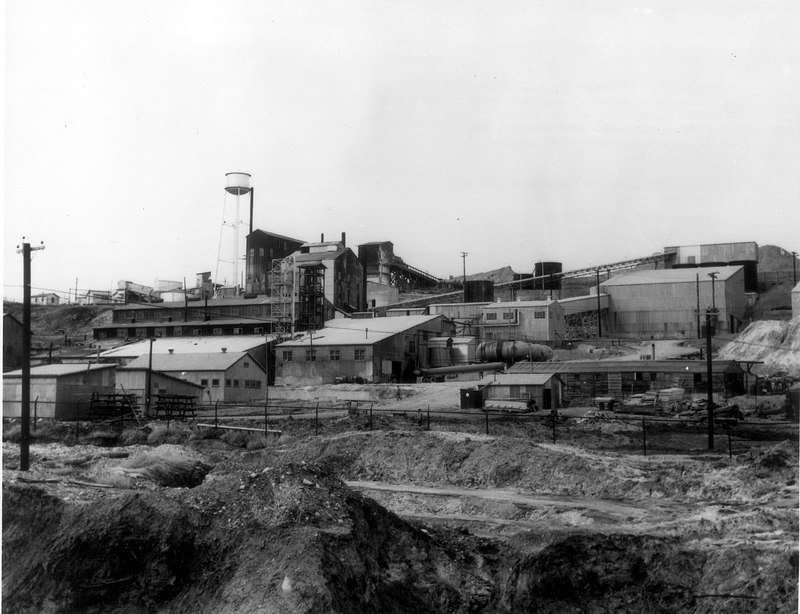
    <summary type="html"><![CDATA[<p><strong><em>Residents of Monticello -  a small town in southeast Utah - are still weighing the economic benefits of the Monticello Mill against the environmental and health problems it caused in their community. </em></strong></p><img src="https://www.intermountainhistories.org/files/fullsize/4267f041bea81fd7d2246268ad36780e.jpg" alt="Monticello Mill" /><br/><p>When a new government-owned mill opened in 1942 in the small town of Monticello, Utah, the local response was overwhelmingly positive. The local paper rejoiced, “Monticello is feeling the influx of much more money… Owners of restaurants, markets, garages, the motion picture house, and other businesses have learned that the coming of a new industry means a new source of income for all.” The new industry that caused the boom in Monticello was the mining and processing of vanadium, and later uranium. Both were essential elements in the production of America’s growing stockpile of nuclear weapons, and both are radioactive. The initial enthusiasm built from promised economic development soured due to pollution and health crises. Even though the EPA has designated two Superfund sites, many locals remain unsatisfied with government efforts to remediate the damage done to their community. </p><p>Economic growth was not the only factor influencing the initial positive reception of the mill. Patriotism also fueled the resident’s support of the mill’s operation. People felt that they were meaningfully contributing to the efforts of the Cold War. San Juan County was touted as “the new muscle behind the American effort in waging total war” and was deemed the “area that has made a greater contribution to the scientific world than any other spot in the universe.” The Department of Energy ran the Monticello Mill, so people employed there were working for the federal government, not a greedy private company. By the 1960s, however, the bottom had fallen out in the uranium industry and after the mill’s closure, people were left in an economic depression and with a lot of unanswered questions. </p><p>For about 40 years after the mill’s closing, over 2 million tons of tailings waste and other contaminated materials sat exposed at the mill site. Wind blew dust from the radioactive waste into the town and contaminated materials used in construction throughout Monticello. In 1993, locals officially formed the committee Victims of Mill Tailings Exposure (VMTE). The VMTE is especially unique because of the lack of organizations like it in the state of Utah. Even though there have been as many as 25 super fund sites in the Beehive State, the VMTE is the only organization that has formed in response to environmental damage done to the community. A memorial funded by the VMTE reads “During the Cold War, we fought against communist ideology, but it was ourselves we were killing.” The tribute continues describing the effects of contamination, “Chrome came off car bumpers. Screen doors changed color. White sheets hung on the line turned yellow, and fumes from the plant were inhaled in the lungs of young and old alike; mill workers, miners, ore haulers, city residents, families and children.” </p><p>Despite the mounting evidence that contaminants have led to an increase in cancer and other disease rates in Monticello, the VMTE continues to fight for at least two things they feel they deserve: access to and payment for adequate treatment. The nearest cancer center over 100 miles away in Durango, Colorado. Some residents travel up to 300 miles for treatment in St. George, Utah. Monticello was once notable as a town whose residents enthusiastically supported of the national government. Today, many demand that the United States take responsibility for its mistakes and provide compensation. One VMTE member explained how fellow townspeople motivate him to keep fighting, “They say ‘Don't stop. We know that mill caused our cancer.’”</p><p><em><strong><a href="https://www.intermountainhistories.org/items/show/377">For more (including 4 images) view the original article</a></strong></em></p>]]></summary>
    <published>2020-01-08T05:53:41+00:00</published>
    <updated>2026-04-17T19:32:07+00:00</updated>
    <link rel="alternate" type="text/html" href="https://www.intermountainhistories.org/items/show/377"/>
    <id>https://www.intermountainhistories.org/items/show/377</id>
    <author>
      <name>Sam Heywood, Brigham Young University</name>
    </author>
  </entry>
  <entry>
    <title type="html"><![CDATA[The Berkeley Mine Pit: Butte’s Scenic Toxic Lake]]></title>
    <summary type="html"><![CDATA[<p><strong><em>The Berkeley Mine Pit is the most expensive site on the EPA’s superfund list, filled with water so acidic it can dissolve the propeller of a boat.</em></strong></p><img src="https://www.intermountainhistories.org/files/fullsize/b0280a5e449e8efb8945c58f3821f84f.jpg" alt="Berkeley Pit" /><br/><p>Butte, Montana’s history is inseparably tied to mining. A gift shop on the outskirts of town sits next to a massive man-made pit filled with 40 billion gallons of water. Some visitors comment on the beauty of the contrast between the “blue sky and emerald green waters” and enjoy signs that give brief snippets about the history of the Anaconda Copper Mining Company and the pit. Others who visit know that that the pit is filled with water so acidic that it can dissolve the propeller of a boat. In 2016 the poisonous water was responsible for the death of an estimated 4,000 geese who stopped for a drink. The Berkeley Mine Pit is now the most expensive site on the EPA’s superfund list.</p><p>Underground mining operations date back to the 1870s in Butte. By 1955, however, Anaconda decided that it would be more profitable and safer for miners to dig straight down to copper veins instead of tunneling to them. This method resulted in a growing pit. The people of Butte proudly identified as miners, but the pit exposed the community to a type of mining never before experienced and they began complaining to company officials about the noise and dust from nearby explosions. As the pit grew deeper and wider and more waste was produced, Anaconda saw only one way to stop complaints and keep their operation going: obtain more land.</p><p>Anaconda faced the task of dismantling communities that they helped create. East Butte, Meaderville, McQueen, Dublin Gulch, and Finn Town were towns of immigrant miners close enough to the Berkeley Pit that the company deemed their destruction necessary to continue mining operations. Fortunately for Anaconda, they already owned most of the land in these towns, they needed only to buy or trade the houses on top of it. A sign by the pit today reads, “many of the relocated residents didn’t mind because it meant that good paying jobs would stay in the community.” While it is true that these communities were eventually abandoned and engulfed by waste or the pit itself, the reality of people leaving their homes, churches, and baseball fields to be destroyed was more complicated. One resident remarked, “People said they’d fight, but then they jumped.”</p><p>Anaconda was no longer the typical pre-WWII mining company that hired detectives to intimidate or beat workers into submission. They used legal means to move workers and their families to different parts of town. They offered fair sums of money for houses or offered a trade so people could immediately move into a house in a different town also owned by Anaconda. Though many took the deals offered by the company, there were always holdouts. In 1961 however, a bill passed in the state legislature that gave private companies like Anaconda the right to exercise eminent domain to expand pit operations. Though the process was used sparingly, Anaconda could take property if they wanted to, making resistance to pit expansion futile. Still, one man in charge of covering the old school in Meaderville with mine waste said, “I felt like a murderer. Progress does have its price.”</p><p>By the 1980s, pressures from environmentalists and the financial state of Anaconda Copper led to the closure of the Berkeley Pit. Pumps that kept surrounding groundwater from the pit were turned off, and the pit has been filling with toxic water ever since. In 1983 the pit was placed on the EPA’s superfund list. Last year, ground was broken on a facility that will stop water in the pit from raising to levels that would poison surrounding water supplies in Butte. The pit stands today as a poignant reminder of the large-scale destructive effects of capitalism in the West and represents the complex relationship between people and the resources on which they depend for jobs, and ultimately, life. The Berkeley Pit cannot be discussed in Butte without a reverence for the thousands of miners that sacrificed limbs, time, and sometimes their lives all to earn a decent wage. As we look forward to solutions for Berkeley, we must not forget to remember how and why it was created.</p><p><em><strong><a href="https://www.intermountainhistories.org/items/show/376">For more (including 4 images) view the original article</a></strong></em></p>]]></summary>
    <published>2020-01-07T03:35:54+00:00</published>
    <updated>2026-04-17T19:32:07+00:00</updated>
    <link rel="alternate" type="text/html" href="https://www.intermountainhistories.org/items/show/376"/>
    <id>https://www.intermountainhistories.org/items/show/376</id>
    <author>
      <name>Sam Heywood, Brigham Young University</name>
    </author>
  </entry>
</feed>