<?xml version="1.0" encoding="UTF-8"?>
<feed xmlns="http://www.w3.org/2005/Atom">
  <title type="text">Intermountain Histories</title>
  <updated>2026-04-17T19:32:18+00:00</updated>
  <generator uri="http://framework.zend.com" version="1.12.20">Zend_Feed_Writer</generator>
  <link rel="alternate" type="text/html" href="https://www.intermountainhistories.org/"/>
  <link rel="self" type="application/atom+xml" href="https://www.intermountainhistories.org/items/browse?output=rss2"/>
  <id>https://www.intermountainhistories.org/</id>
  <author>
    <name>Intermountain Histories</name>
    <uri>https://www.intermountainhistories.org</uri>
  </author>
  <link rel="hub" href="https://pubsubhubbub.appspot.com/"/>
  <entry>
    <title type="html"><![CDATA[Boom and Bust in Bodie, CA]]></title>
    <summary type="html"><![CDATA[<p><strong><em><span style="font-weight:400;">Once among the largest and most prosperous towns in California, Bodie is now defined by the ghost of its past in the form of abandoned objects, peeling wallpaper, and half-destroyed buildings. </span></em></strong></p><img src="https://www.intermountainhistories.org/files/fullsize/24dc4420a11bbf404db7f58bf5daf143.jpg" alt="Old buildings in Bodie, California" /><br/><p><span style="font-weight:400;">In the summer of 1859, W. Bodey found rich gold deposits in California, seven miles west of the Nevada border. He had traveled from Poughkeepsie, New York, in pursuit of an adventure, and his discovery would lead to the town of Bodie and surrounding hills being named in his honor. His name is something of a mystery today; there are reports that refer to him as William, Waterman, and Wakeman, his second initial as either “T” or “S,” and his last name occasionally spelled as Body rather than Bodey. As for the spelling of the town’s name, the “ie” ending was initially the result of a confused sign painter, and it just stuck. </span>
<span style="font-weight:400;">Bodey’s ambition to find more for himself in life fueled both his success and his downfall. He was one of the first to discover gold in eastern California and managed to survive the dire circumstances of early prospecting life through the first change of seasons. It wasn't the work in the mines during the summer that killed him, but the harsh winter that followed. In November 1859 Bodey and his traveling companion left camp to get supplies. They were caught in a blizzard, and Bodey–unable to keep up with his companion–was left to die. His remains were recovered and now lie beneath two headstones: one that reads “Waterman S. Bodey” with an engraved image of miners panning gold from a stream against a backdrop of mountains; and another, much smaller with the name “William S. Bodey.”</span>
<span style="font-weight:400;">In the years following his death, the town of Bodie was brought to life by other ambitious miners and their families, bringing the town’s population to 10,000 in 1879. With so many people arriving in such a short period of time, most of them lived in tents–even after the town became more established. In 1881 the Bodie and Benton Railway was built and used to haul lumber and other goods from the Bodie mines to the saw mill by Mono Lake. Bodie was becoming a prosperous center for work. It served some twenty-two gold and silver mines in the region with a stamp mill for processing ore and plenty of businesses in town. Saloons dominated, but there was also a mercantile, several general stores, motels, gambling and dancing halls, schools, stables, and both a Catholic and a Methodist church. </span>
<span style="font-weight:400;">Like its namesake, the town is no stranger to tragedy and risk. Two accidental fires–one from a kitchen in 1892 and another started by a child in 1932–caused the destruction of several main street buildings, and led to economic hardship. Combined with the sundry difficulties of the Great Depression, the town failed to recover. It joined the arid region’s long list of ghost towns. Weather conditions in the mountains are still just as treacherous as they were in W. Bodey’s fateful last days. Travel to Bodie during winter months is only possible by way of skis, snowshoes, or snowmobiles. </span>
<span style="font-weight:400;">In an attempt to preserve the historic elements of the town, Bodie was made an official California State Park in 1962. Only five percent of what once made up the booming town of Bodie is thought to have survived, and today its ghost-like remains sit virtually untouched in tattered buildings and houses. </span></p><p><em><strong><a href="https://www.intermountainhistories.org/items/show/806">For more (including 6 images) view the original article</a></strong></em></p>]]></summary>
    <published>2024-05-16T02:01:48+00:00</published>
    <updated>2026-04-17T19:32:18+00:00</updated>
    <link rel="alternate" type="text/html" href="https://www.intermountainhistories.org/items/show/806"/>
    <id>https://www.intermountainhistories.org/items/show/806</id>
    <author>
      <name>Megan Bailey, Brigham Young University</name>
    </author>
  </entry>
  <entry>
    <title type="html"><![CDATA[Kodachrome Basin and the Power of Photography]]></title>
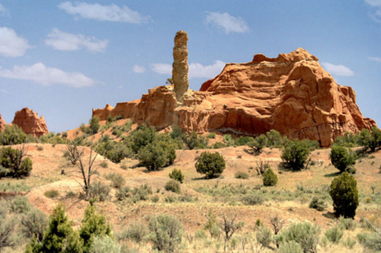
    <summary type="html"><![CDATA[<p><strong><em>Kodak released its first roll of colored film in 1936 called “Kodachrome.” This film became famous for its new method of producing color in still photography. Its use became widespread among National Geographic photographers, eventually leading to global awareness of the beauty of Southern Utah’s rust colored landscape. </p></strong></p><img src="https://www.intermountainhistories.org/files/fullsize/ef773cd98552f15f18157825eb6cc132.jpg" alt="My Beautiful Picture" /><br/><p><span style="font-weight:400;">In 1948, a group of National Geographic photographers, led by Jack Breed, set out to explore the Southern Utah terrain. Using trails only having ever been passed in modern times by a handful of cattle ranchers, Breed and his crew found a landscape that was relatively untouched. Traveling by car and hiking into more rugged regions, the National Geographic explorers found the contrasting colors of the land to be enchanting. The explorers nicknamed the area “Kodachrome Flat” after the film used to capture the rust colored canyons. Photos taken of the area were later published in a 1949 edition of National Geographic magazine, which had 60 million readers. </span>
<span style="font-weight:400;">Members of the Church of Jesus Christ of Latter-Day Saints who lived in the region were highlighted in the article as well as the landscape. Dressed in pioneer clothing, Breed photographed them recreating a traditional Latter-Day Saint dance in the Kodachrome area, perhaps using the peculiarity to catch readers’ attention. Before the photos were published in the magazine, they were shown to local members of the Lions Club at the Cameron Hotel in Panguitch. Crew member Burnett Hendryx spoke of the National Geographic team’s adventures in the desert. The invitation to view Hendryx’s photos was then extended to the general public who marveled at the color photographs.. This expedition was of great interest to the local residents of Garfield County, not only for the excitement the National Geographic visit sparked in local newspapers, but also because the highly publicized article brought tourists to the county, boosting its isolated economy. </span>
<span style="font-weight:400;">Although originally named Chimney Rock State Park due to copyright issues, the area today is officially known as Kodachrome Basin State Park. It sits in a quiet location between Bryce Canyon and Escalante National Park and is home to a plethora of campsites and hiking trails. It continues to be a tourist site, especially popular among foreigners. The park hosted a total of 179,121 visitors in 2022 and its popularity continues to grow. </span></p><p><em><strong><a href="https://www.intermountainhistories.org/items/show/772">For more (including 3 images) view the original article</a></strong></em></p>]]></summary>
    <published>2024-01-21T22:08:05+00:00</published>
    <updated>2026-04-17T19:32:17+00:00</updated>
    <link rel="alternate" type="text/html" href="https://www.intermountainhistories.org/items/show/772"/>
    <id>https://www.intermountainhistories.org/items/show/772</id>
    <author>
      <name>Jane Carlson, Brigham Young University</name>
    </author>
  </entry>
  <entry>
    <title type="html"><![CDATA[Kam Wah Chung &amp; Co. ]]></title>
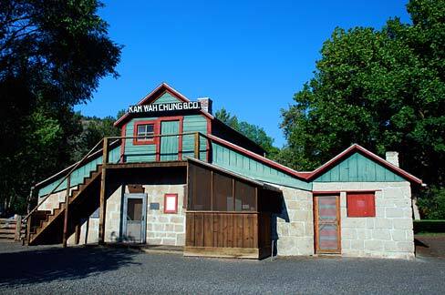
    <summary type="html"><![CDATA[<p><strong><em>In the 19th century, the United States rapidly expanded West. This expansion was expedited by the discovery of gold in the western mountains. Along with it came an influx of Chinese workers. As anti-Chinese sentiment festered during the latter half of the century, a medicine shop rose to prominence in John Day, Oregon.</em></strong></p><img src="https://www.intermountainhistories.org/files/fullsize/5bc7a3df9efef6793d330b545baa0691.jpg" alt="Kam Wah Chung Museum" /><br/><p><span style="font-weight:400;">Along the Dalles Military Road sits the small town of John Day, Oregon. In the mid-1860s, a Chinatown hub for the Chinese miners and immigrants emerged in the area. A small wooden building purchased by Ing Hay and Lung On served as the foundation for a business with—at the time—no promises for future success.</span> <span style="font-weight:400;">Ing Hay was both an herbalist and pulsologist, diagnosing patients based on their pulse. Born in 1862, he sought better fortunes in the Western United States in 1887. In John Day, Oregon, he met Lung On and purchased the dying Kam Wah Chung & Co. Locally known as “Doc” Hay, he treated a variety of ailments with traditional Chinese remedies based on Taoist teachings of harmony and balance. His clientele diversified and included more non-Chinese patients through the 1910s. </p> <span style="font-weight:400;">Lung On, on the other hand, was a savvy businessman fluent in both Chinese and English. He was also a Chinese immigrant and managed the business side of Kam Wah Chung which included pricing, inventory, translating and responding to letters. Locally known as “Leon”, he owned, co-owned, and invested in numerous other operations around Oregon, including businesses, land and mining claims, racehorses, and later an automotive dealership. He also provided a letter-writing service and assistance in navigating American laws for Chinese migrants and immigrants.</p> <span style="font-weight:400;">Together, the two transformed Kam Wah Chung & Co. into a successful mercantile, apothecary, and clinic. It also served as an education and community center. Kam Wah Chung served as an anchor for the surrounding Chinese community and a bridge for non-Chinese neighbors during an era of heightened anti-Chinese sentiment. This success continued into the early 20th century until Lung On’s death in 1940. Ing “Doc” Hay moved to Portland in 1948 due to failing health. The Kam Wah Chung & Co. has been converted into a museum that houses a plethora of Lung On’s untranslated ledgers and documents, Chinese medicinal recipes from Ing Hay’s days of practice, and records of the significant footprint Hay and On left on western U.S. history.</span>
<i><span style="font-weight:400;">Friends Of Kam Wah Chung, </span></i><span style="font-weight:400;">a non-profit organization, continues to research, translate, and excavate the cultural artifacts left behind in John Day. More information about current research and the museum can be found on their website, and much of their work is available to the public. Kam Wah Chung is now a state park and National Historical site.</span></p><p><em><strong><a href="https://www.intermountainhistories.org/items/show/743">For more (including 6 images) view the original article</a></strong></em></p>]]></summary>
    <published>2023-04-10T19:33:02+00:00</published>
    <updated>2026-04-17T19:32:16+00:00</updated>
    <link rel="alternate" type="text/html" href="https://www.intermountainhistories.org/items/show/743"/>
    <id>https://www.intermountainhistories.org/items/show/743</id>
    <author>
      <name>Emma Dutcher, Brigham Young University</name>
    </author>
  </entry>
  <entry>
    <title type="html"><![CDATA[A Brief History of Antelope Island]]></title>
    <summary type="html"><![CDATA[<p><strong><em>Antelope Island is located in the Great Salt Lake, Utah. Both humans and animals have utilized this land for thousands of years. Antelope Island, sometimes connected to the mainland at low tide, contains natural resources, diverse animal species and ecosystems. </em></strong></p><img src="https://www.intermountainhistories.org/files/fullsize/551392983ad745092c1f6292f583e72e.jpg" alt="Black Rock and Antelope Island, Salt Lake" /><br/><p>Antelope Island represents the largest island within the Great Salt Lake, covering an area of 42 square miles. First inhabited by indigenous natives about 2,000 years ago, natives utilized Antelope Island up until the 1840’s. Indigenous camps discovered on the island provide the knowledge of this use. In 1845, John C. Fremont and Kit Carson explored the island and documented their expedition. Carson’s journal states that he and Fremont hunted Pronghorn Antelope on this island, just like the members of the Ute tribe, and decided to name the island after the animal. </p><p>In 1848, The Church of Jesus Christ of Latter-day Saints moved a herd of cattle to the island under the rancher Fielding Garr. The Church continued to run a ranch on the island until 1875, when the homestead movement and the Union Pacific Railroad required land, causing the Church to abandon its use on the island. The land passed through the hands of numerous owners throughout the years until it was purchased in totality in 1981 by the State of Utah. </p><p>John White and John Dooly, the ranchers during that time, introduced twelve bison to the island in 1893. Overgrazing and overpopulation with the grazing animals on the island caused it to become necessary to cull and relocate the herd regularly. The herd created a significant genetic pool for use in bison conservation and breeding efforts today. In modern time, numerous species of animals reside on the island, including bighorn sheep, deer, birds, pronghorn, bobcats, among numerous other species. </p><p>Antelope Island contains many natural resources. Mining activity included prospecting for slate (1874), gold and copper (1899), oil (1904), and sand and gravel deposits (1967). Eventually, the State of Utah purchased part of Antelope Island in 1969 and bought the rest in 1981, when it officially became a part of the Utah State Parks System. Mining activities halted in 1979 and the state park, which opened to the public in 1993, is currently a habitat for the wildlife inhabiting the island. </p><p><em><strong><a href="https://www.intermountainhistories.org/items/show/297">For more (including 4 images) view the original article</a></strong></em></p>]]></summary>
    <published>2019-02-13T09:59:39+00:00</published>
    <updated>2026-04-17T19:32:05+00:00</updated>
    <link rel="alternate" type="text/html" href="https://www.intermountainhistories.org/items/show/297"/>
    <id>https://www.intermountainhistories.org/items/show/297</id>
    <author>
      <name>Jessica Newman, Brigham Young University</name>
    </author>
  </entry>
</feed>