<?xml version="1.0" encoding="UTF-8"?>
<feed xmlns="http://www.w3.org/2005/Atom">
  <title type="text">Intermountain Histories</title>
  <updated>2026-04-17T19:32:20+00:00</updated>
  <generator uri="http://framework.zend.com" version="1.12.20">Zend_Feed_Writer</generator>
  <link rel="alternate" type="text/html" href="https://www.intermountainhistories.org/"/>
  <link rel="self" type="application/atom+xml" href="https://www.intermountainhistories.org/items/browse?output=rss2"/>
  <id>https://www.intermountainhistories.org/</id>
  <author>
    <name>Intermountain Histories</name>
    <uri>https://www.intermountainhistories.org</uri>
  </author>
  <link rel="hub" href="https://pubsubhubbub.appspot.com/"/>
  <entry>
    <title type="html"><![CDATA[Ferron, Emery County, Utah: A History of Early Settlement]]></title>
    <summary type="html"><![CDATA[<p><strong><em><span style="font-weight:400;">Ferron, Utah, fixed east of the Wasatch Plateau and west of the San Rafael Swell, in Emery County, was the last major area Brigham Young had called people to settle before he passed away in August 1877. The letter came to Saints in Sanpete County to go east over the Wasatch Mountains and settle in Castle Valley.</span></em></strong></p><img src="https://www.intermountainhistories.org/files/fullsize/aae7faea418932abc510d9073c3d522c.jpg" alt="[Untitled]" /><br/><p><span style="font-weight:400;">The need for expansion into Castle Valley came from Utah’s population rise in the late 19</span><span style="font-weight:400;">th</span><span style="font-weight:400;"> century. Every inch of habitable land needed to be used to ease the rapidly increasing population. Brigham Young called settlers in Sanpete County to move to Castle Valley.  This area was explored as early as 1776 when Domingues and Escalante traveled into Utah; they passed through modern day Castle Dale, ten miles north of Ferron on the Old Spanish Trail. Today I-70 follows parts of the Old Spanish Trail that cuts through the San Rafael Swell.</span>
<span style="font-weight:400;">As Edward Geary has written, “Few places on earth could have looked less promising for settlement than Castle Valley in 1877.” Three years after Brigham Young’s letter to the residents of Sanpete Valley, Ferron’s population had grown to 90 in 1880. On coming to the Castle Valley, Mary Ann Rowbury Brown said, “We endured willingly many hardships and cheerfully made sacrifices in order to carry on what we sincerely believed to be God’s works in subduing a desert and advancing civilization.”</span>
<span style="font-weight:400;">The state and federal governments created incentives to help cultivate land across the nation and encourage westward expansion. In 1862, the Homestead Act gave settlers 160 acres for a small registration fee if they developed the land and improved it. In 1878, the amended Timber Culture Act also gave a way to get more land if one would plant 10 acres of trees on their given acreage. The Timber Culture Act was the way one Ferron settler, John Lemon, obtained his land. Homesteading and farming was the norm in the beginnings of Ferron. Lowry Nelson, an early resident of Ferron, said, “Precipitation was so scant that plant life was limited, except along the creek bottoms.” </span>
<span style="font-weight:400;">In the late 1870’s mining began to boom in Emery County and Carbon County. This boom created jobs for people in the area, not just in the coal mines, but created a market that was not there before for farming, creating a demand for produce. Coal mining also boosted the erection of the Hunter and Huntington Power Plants in the 1970s and 1980s.</span>
<span style="font-weight:400;">Aside from farming, livestock was a fruitful business. The unique geography of Castle Valley made raising livestock a minimal expense. In the summers one could free range cattle, horses, or sheep up in the mountains and in the winter bring them down from the mountain and leave them on the desert range. Fruit farming in Ferron also began early. The growing season was tough in Emery County for fruit trees, but Ferron’s southern exposure, and deep, well-drained soil made it the best place to grow fruit in Castle Valley.” The tradition of raising livestock and planting peach orchards has continued today and is a big part of the culture in the area today. Each summer Ferron holds The Southeastern Utah Junior Livestock Show and has an annual Peach Days celebration held at the beginning of September during prime peach season. </span></p><p><em><strong><a href="https://www.intermountainhistories.org/items/show/886">For more (including 3 images) view the original article</a></strong></em></p>]]></summary>
    <published>2025-01-29T02:01:48+00:00</published>
    <updated>2026-04-17T19:32:20+00:00</updated>
    <link rel="alternate" type="text/html" href="https://www.intermountainhistories.org/items/show/886"/>
    <id>https://www.intermountainhistories.org/items/show/886</id>
    <author>
      <name>Mason Saili Faimalo, Brigham Young University</name>
    </author>
  </entry>
  <entry>
    <title type="html"><![CDATA[Jacob Hamblin Home]]></title>
    <summary type="html"><![CDATA[<p><strong><em><span style="font-weight:400;">The Jacob Hamblin home rests atop a small hill in the southern Utah pioneer town of Santa Clara. It stands as a monument to the man who played an important role as an Indian agent to the Paiutes and a community leader in southern Utah during the Latter-day settlement period.</span></em></strong></p><img src="https://www.intermountainhistories.org/files/fullsize/046e4adca37e858735e09524a06f24d0.jpg" alt="Jacob Hamblin Home" /><br/><p><span style="font-weight:400;">The Jacob Hamblin home has its stone foundation buried deep in the history of southern Utah. As a teenager, Jacob Hamblin had a spiritual experience wherein he felt called to work as an intermediary between the Latter-day Saints and Natives, which he felt was a lifetime calling. In 1854, Brigham Young called Hamblin and two dozen men to serve in the Southern Utah Indian Mission to work among the Paiutes. Hamblin founded the town of Santa Clara that same year, naming it after the nearby Santa Clara River. Hamblin and other Latter-day Saint newcomers recruited local Paiutes to assist them in the construction of Fort Clara. Hamblin and his family lived there until a great flood destroyed the fort and much of the settlement in 1862. </span>
<span style="font-weight:400;">With Fort Clara destroyed, leaders of The Church of Jesus Christ of Latter-day Saints sent skilled stone mason to build Hamblin a home for Hamblin and his family, consisting of wives Rachel Judd, Sara Priscilla Leavitt, and their respective children in 1863. After Rachel passed away he married Louisa Bonelli in 1865. The Hamblin home operated as the mission home, yet his important duties as president of the Southern Utah Indian Mission and as an Indian agent kept Hamblin from being home on many occasions. Yet, his endeavors in the region proved influential and significant for the Church and to Utah Territory. In 1868 the families moved to Kanab, where he continued his missionary labors among the Hopis and Navajos. Hamblin’s wife Priscilla fondly recalled, “With regrets, we left the big rock house in Santa Clara [in 1868]. This had been our first real home.”</span>
<span style="font-weight:400;">Jacob Hamblin’s work took him throughout Utah, Nevada, New Mexico, and Arizona. Between 1858 and 1863 he circumnavigated the Grand Canyon by boat. Later, in 1867, Hamblin floated down the Colorado River from the mouth of the Grand Wash to the Virgin River. In addition to his exploration ventures, Hamblin worked hard to establish peaceful relations with the neighboring tribes. In one such instance, local Paiutes worked with Latter-day Saints to build a dam to hold water for irrigating land around Santa Clara. In 1856, little rain fell and the crops wilted. Some Paiutes blamed Hamblin. </span>
<span style="font-weight:400;">The next morning Hamblin prayed, asking God for rain so that the settlers and Paiutes might maintain good relations. Having received an answer, Hamblin reported to all that they would indeed have the water they needed. The following day it began to rain, and that year the settlers and Paiutes grew record crops. From that time on, Hamblin held great standing among the Paiutes. Hamblin also brokered a peace between the Latter-day Saints and the Navajos at Fort Defiance, Arizona. Hamblin’s life is replete with moments like these—miracles, treaties, and the development of great relations with Natives. While Jacob Hamblin and his family only lived in the Jacob Hamblin home for several years, it stands as a lasting testament to the man who proved so instrumental in the development of southern Utah.</span></p><p><em><strong><a href="https://www.intermountainhistories.org/items/show/882">For more (including 5 images) view the original article</a></strong></em></p>]]></summary>
    <published>2025-01-27T05:47:00+00:00</published>
    <updated>2026-04-17T19:32:20+00:00</updated>
    <link rel="alternate" type="text/html" href="https://www.intermountainhistories.org/items/show/882"/>
    <id>https://www.intermountainhistories.org/items/show/882</id>
    <author>
      <name>Hayden Cottle, Brigham Young University</name>
    </author>
  </entry>
  <entry>
    <title type="html"><![CDATA[The Lonetree Mercantile and Post Office]]></title>
    <summary type="html"><![CDATA[<p><strong><em><span style="font-weight:400;">In the center of a ranching town called Lonetree, there is an old building with a white façade and log construction that once functioned as the Post Office and mercantile store for the remote community. From 1897 to 1982, the store served as the nerve center for the community.</span></em></strong></p><img src="https://www.intermountainhistories.org/files/fullsize/de8a2ff11079a55bb74a187bf6522441.jpg" alt="Ranchers pose in front of the Lonetree Mercantile. " /><br/><p><span style="font-weight:400;">Lonetree, Wyoming, is situated just north of the high Uinta Mountains and twenty miles south of Fort Bridger. Henrys Fork River, a tributary of the Green River, first brought fur-trading Europeans to the area. Those who stayed were the descendants of LDS pioneer Captain Isaac Bullock. Bullock was sent to the area by Brigham Young in the early 1850s.</span><span style="font-weight:400;"> The Bullocks were joined by many other families. These homesteaders eventually turned to ranching. </span>
<span style="font-weight:400;">In 1897, an immigrant from Manchester, England, named Herbert Joshua Gregory came to Lonetree. Since the old post office run by R. Handley had burned down, Gregory built his own.</span><span style="font-weight:400;"> Gregory’s store provided necessary supplies and correspondence to the ranchers and townspeople in the area. A visitor to the store could expect news of deaths, births, stolen livestock, grazing permits, events, and even outlaws.</span><span style="font-weight:400;"> Dances, turkey hunts, games, and gatherings of all kinds took place around the Gregory store.</span><span style="font-weight:400;"> It is said that Butch Cassidy and the Sundance Kid were among the outlaws who stopped by Gregory’s store and interacted with members of the community.</span><span style="font-weight:400;"> Gregory was the postmaster until his death in 1952, and the title of postmaster would remain in his family until 1982 when the post office closed.</p><span style="font-weight:400;">Thanksgiving in Lonetree, 1890, made for a popular story. It is said that a Pinkerton agent came to the Gregory store and formed a posse to catch two outlaws who were riding towards Lonetree. One of the outlaws was Harry Alonzo Longabaugh or the Sundance Kid. H. J. Gregory, the town fiddler, and several others rode out to apprehend them. With no fiddler, the Thanksgiving dance could not begin. While people milled around the schoolhouse, Harry Longabaugh and his partner walked into the Gregory store. The story says that the townspeople captured Longabaugh and made him play the fiddle for their dance where he stayed long enough to dance with a woman and escape before the return of the Pinkerton agent.</span><span style="font-weight:400;"> </span>
<span style="font-weight:400;">Lonetree remains a ranching community with a small population that has not forgotten its origins in the Wild West.</span></p><p><em><strong><a href="https://www.intermountainhistories.org/items/show/875">For more (including 4 images) view the original article</a></strong></em></p>]]></summary>
    <published>2025-01-23T00:33:27+00:00</published>
    <updated>2026-04-17T19:32:20+00:00</updated>
    <link rel="alternate" type="text/html" href="https://www.intermountainhistories.org/items/show/875"/>
    <id>https://www.intermountainhistories.org/items/show/875</id>
    <author>
      <name>Landon Wilson, Brigham Young University</name>
    </author>
  </entry>
  <entry>
    <title type="html"><![CDATA[North Beach at Bear Lake: The &quot;Caribbean of the Rockies&quot;]]></title>
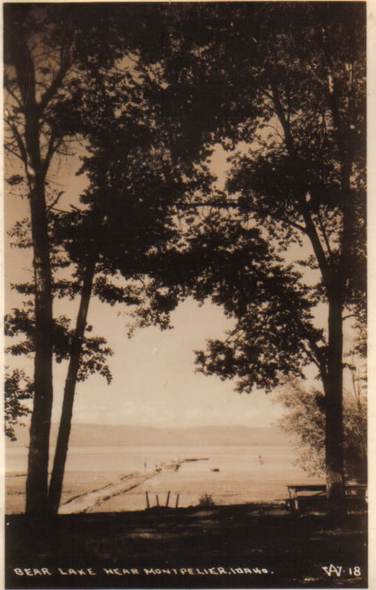
    <summary type="html"><![CDATA[<p><strong><em>Known as the "Caribbean of the Rockies," North Beach at Bear Lake is remembered for its clear, turquoise waters and the neighboring historical hot springs.</em></strong></p><img src="https://www.intermountainhistories.org/files/fullsize/10473506f86f1e2d1f5ca0c2d8a1af4f.jpg" alt="Bear Lake near Montpelier, Idaho. c. 1898" /><br/><p>The sandy shores of North Beach at Bear Lake meet the turquoise waters that inspired the nickname “Caribbean of the Rockies” and have made the beach a main tourist attraction at the Utah-Idaho border. North Beach sits on Idaho territory and provides activities such as boating, fishing, jet skiing, kayaking, picnicking, sunbathing, and swimming. Paired with these activities are the amenities, which include a boat launch ramp, grills, campgrounds, and picnic tables. In 2022 alone North Beach had over 300,000 visitors as it is a great place for families to come and wade in the shallow, warm waters.</p><p>Bear Lake has 12,000 years of Indigenous history as Native Americans would settle on the beach’s shores and use the waters for fishing and the surrounding areas for plant gathering and hunting. The native tribes that live near North Beach today are the Shoshone and Bannock tribes of southern Idaho. Following the Oregon Trail, Mormon settlers were the next prominent group to live in Bear Lake Valley. They negotiated with the Shoshone tribe for part of the land and established the community of Paris in 1863. Joseph C. Rich was an early pioneer at Bear Lake and married Ann Eliza Hunter. Together they developed the make-shift hot springs at North Beach in 1888 that used an underground pipeline to bring the hot water from the springs to the bathing pools.</p><p>Decades later in 1911, Ethel Bates became the owner of the Grand Hotel built next to the hot springs bath. The hotel became a well-known place to enjoy the scenic views of Bear Lake and allowed visitors to have multiple days at the beach. In 1939, the hotel burned down, leaving only a few pillars and stairs people can visit today. Ruth and Lorenzo Hemmert bought the property in 1950 to rebuild the lodging amenities and renovate the hot spring pools. They owned the property until 2018 when it sold to a land developer who plans to tear down the existing buildings to make room for a subdivision called Lakeview.</p><p>After years of rising popularity, in the late 1960s and early 1970s, there was much conversation about expanding the facilities because of overcrowding. In 1969 the Idaho State Journal noted that about 3,500 persons visited North Beach daily during peak summer days. Construction occurred during the early 1970s and included new campgrounds, restrooms, picnic facilities, and access to running water to mitigate overcrowding and improve sanitation.</p><p>The popularity of North Beach still reigns true and visitors must reserve a spot on the beach, up to one day in advance. Bear Lake and especially North Beach have also been the victim of drought over the past years. Bear Lake Idaho’s brochure notes the “low water levels” and how public use and the exposed lake bed have “created a concern for the lake’s environment and safe recreation use.” Respecting the beach is crucial for a future of sunbathing, swimming, and other beach activities at the “Caribbean of the Rockies.”</p><p><em><strong><a href="https://www.intermountainhistories.org/items/show/828">For more (including 5 images) view the original article</a></strong></em></p>]]></summary>
    <published>2024-05-23T01:05:00+00:00</published>
    <updated>2026-04-17T19:32:18+00:00</updated>
    <link rel="alternate" type="text/html" href="https://www.intermountainhistories.org/items/show/828"/>
    <id>https://www.intermountainhistories.org/items/show/828</id>
    <author>
      <name>Olivia Hall, Northern Arizona University</name>
    </author>
  </entry>
  <entry>
    <title type="html"><![CDATA[Saltair Beach at Great Salt Lake: The &quot;Coney Island of the West&quot; ]]></title>
    <summary type="html"><![CDATA[<p><strong><em>Attracting visitors to float in its salty waters, the southern beaches at Great Salt Lake became increasingly popular with the Saltair Resort but now face environmental threats.</em></strong></p><img src="https://www.intermountainhistories.org/files/fullsize/1dca8d46b480914c5e65caf4b1a71f24.jpg" alt="[Untitled]" /><br/><p>The Great Salt Lakes' southern beach became a well-known vacation spot because of the Saltair Resort and its motto “Try to Sink” which encouraged visitors' curiosity to swim and float in the salty waters. Today, the beach has seen a drop in visitation due to receding water levels, with about 130,000 fewer visitors from 2012 to 2022. At the beach's peak visitation during the late nineteenth century and early twentieth century, beach life consisted of swimming, picnicking, and carnival rides such as a rollercoaster, merry-go-round, and Ferris wheel.</p><p>The Goshute tribe and the Skull Valley Goshutes live near and still use the resources of the southern end of Great Salt Lake. In 1847, Mormon settlers first came to Salt Lake Valley and initiated the recreational beach life on the lake. In the 1860s, Mormon settler Heber Kimball built a ranch near Black Rock Beach. Known later as “Rock House” this spot became the first well-known swimming spot on the lake. Attraction grew with the completion of the Utah Central Railroad in 1870 and the Utah-Nevada Railway in 1875 which made Black Rock and the future Saltair Beach accessible to transcontinental visitors.</p><p>In 1893, Deseret News announced the construction of a new resort called “Saltair.” The Church of Jesus Christ of Latter-day Saints invested the most money in the Saltair Beach Company and hoped to create a wholesome recreational resort that was family-oriented. Saltair opened in 1893 and soon was nicknamed “Coney Island of the West” for its many carnival and recreational attractions. The beaches were most popular on American holidays such as the Fourth of July with thousands of people visiting to swim on weekends and special occasions. In 1919 attendance reached 450,000 people and the resort's popularity peaked during the 1920s. However, on April 22, 1925, Saltair burned down for unknown reasons, and by the 25th, its manager announced rebuilding efforts with no proposed start date. With the promise to be “larger, stronger, and more beautiful” than ever by the Salt Lake Tribune, the second Saltair opened in May of 1926. Nonetheless, the resort did not live up to its predecessor and presently the third Saltair, due to another fire, serves as a concert venue.</p><p>Saltair was the center of beach life at the southern shore of Great Salt Lake, and with the decline of the resort came the decline of beach life. The latest reviews describe the beach as having great views, but decreasing water levels means a long and smelly walk to the water. In 2023 alone the lake lost two feet of water to evaporation and while Utah policymakers and environmental programs have forged a plan to save the lake, they did not include any Native tribes in the conversation. Today, people can still swim, or rather float, in the 12% average salinity levels of the Great Salt Lake compared to the Pacific Ocean's 3.5% average salinity. As well as kayak, boat, and sunbathe on the southern beach's shores and marina.</p><p><em><strong><a href="https://www.intermountainhistories.org/items/show/827">For more (including 5 images) view the original article</a></strong></em></p>]]></summary>
    <published>2024-05-23T00:29:57+00:00</published>
    <updated>2026-04-17T19:32:18+00:00</updated>
    <link rel="alternate" type="text/html" href="https://www.intermountainhistories.org/items/show/827"/>
    <id>https://www.intermountainhistories.org/items/show/827</id>
    <author>
      <name>Olivia Hall, Northern Arizona University</name>
    </author>
  </entry>
  <entry>
    <title type="html"><![CDATA[Joseph F. Smith and the Islanders of Iosepa]]></title>
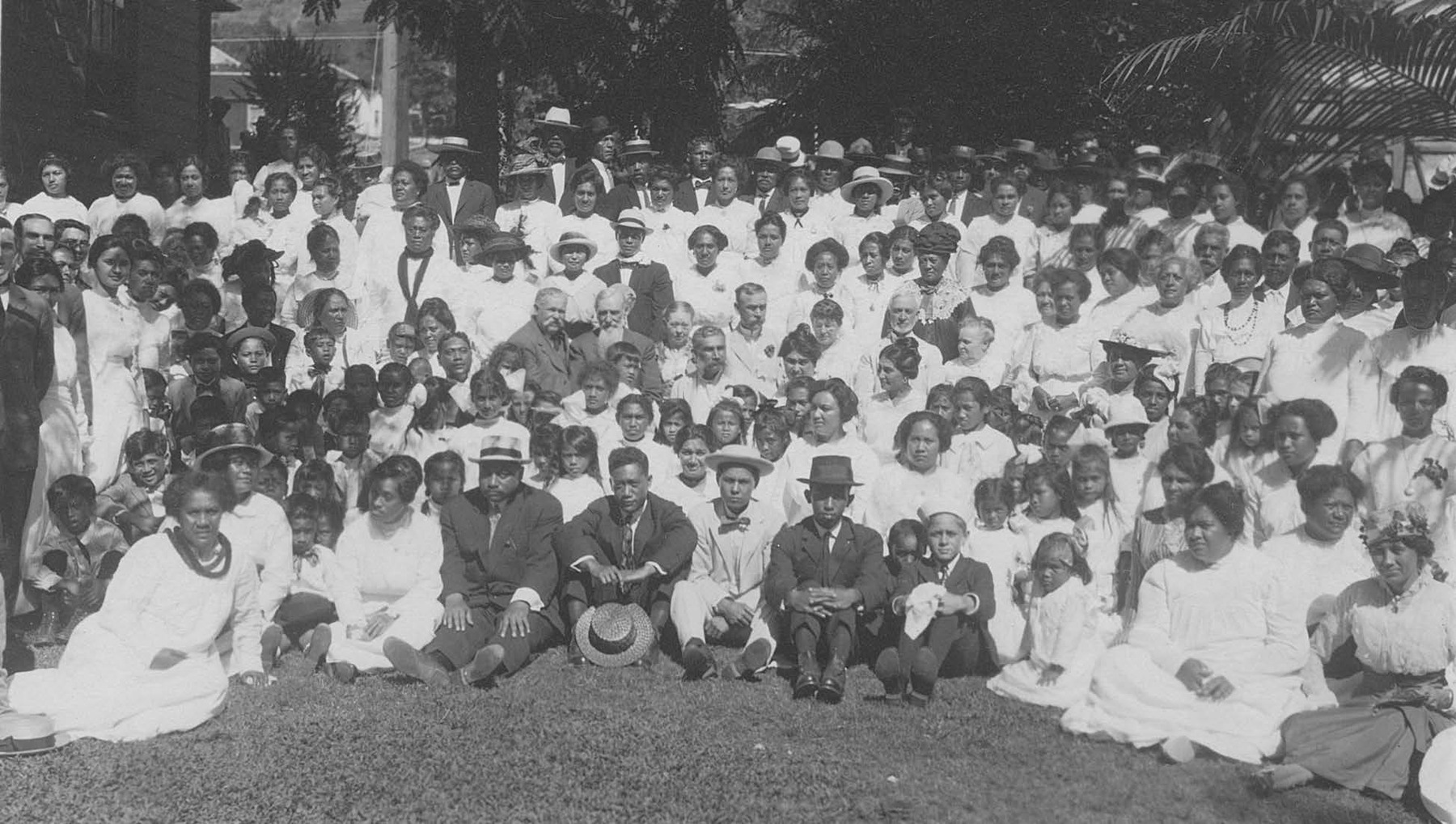
    <summary type="html"><![CDATA[<p><strong><em>The Hawaiian members of the Church of Jesus Christ of Latter-day Saints had a very special relationship with the Church’s sixth president, Joseph F. Smith. He was influential in Hawaiian migrations both to and from Utah, including during the time that many of them resided in Iosepa, a Hawaiian colony.</p></strong></p><img src="https://www.intermountainhistories.org/files/fullsize/c4441ee0af02c1fa09ac1230935470cc.jpg" alt="Joseph F. Smith and Hawaiian Saints" /><br/><p><span style="font-weight:400;">At the age of fifteen, Joseph F. Smith served as a missionary for the Church of Jesus Christ of Latter-day Saints in the Hawaiian Islands in the early 1850s. During his several missions, Smith learned the Hawaiian language and developed a loving relationship with the Native Hawaiians. Throughout his life, Smith traveled to Hawaii more often than any other place outside of the western United States. Smith was successful in converting many Hawaiians to the LDS Church. The doctrine of gathering to “Zion” was a central teaching preached by Joseph F. Smith and other missionaries at that time. When immigration laws allowed it, a few hundred Hawaiian Latter-day Saints migrated to Utah to gather with their fellow Saints and to follow the teachings they had received. The Islanders experienced racism, discrimination, job-turnover, and prejudice that led the LDS Church to seek solutions. In 1889, a settlement was established in Tooele County for the Pacific Islanders settling in Utah. It was to be named after Joseph F. Smith, which in the Hawaiian Language is “Iosepa.” At that time, Smith was a member of the Church’s First Presidency and would later become the President of the Church.</span>
<span style="font-weight:400;">In both public and private correspondence, Joseph F. Smith was explicit in expressing his love for the Iosepan Saints. With a letter to S. M. Kinimakalehua of Iosepa, Smith sent “some cloth pants for the cold time that is coming… This is only rags, but take it with my love.” He reported that “Canon [George Q. Cannon] is joining with my family and I in sending a lot of our love to you and Makaweli and all of the Saints in Iosepa.” During a visit to Hawaii in 1915, Smith became convinced of the need for a temple in Hawaii. Upon returning to Utah, he encouraged the Hawaiian Saints to move back to Hawaii and help build a temple in La’ie. Smith also thought that the future Church Presidents would not have the same love for the Hawaiians that he did, which influenced his encouragement of the Islanders to return to their homeland. The Saints trusted in the council of Joseph F. Smith, and most resettled near the temple site in Hawaii. The settlement of Iosepa was fully abandoned by 1917. In November of 1918, Joseph F. Smith passed away and one year later the La’ie Temple was completed. </span></p><p><em><strong><a href="https://www.intermountainhistories.org/items/show/780">For more (including 4 images) view the original article</a></strong></em></p>]]></summary>
    <published>2024-02-24T03:37:50+00:00</published>
    <updated>2026-04-17T19:32:17+00:00</updated>
    <link rel="alternate" type="text/html" href="https://www.intermountainhistories.org/items/show/780"/>
    <id>https://www.intermountainhistories.org/items/show/780</id>
    <author>
      <name>Jordan Castillo, Brigham Young University</name>
    </author>
  </entry>
  <entry>
    <title type="html"><![CDATA[Honeymoon Trail]]></title>
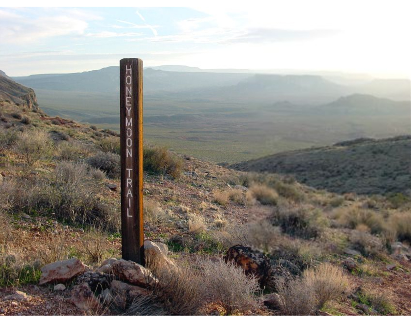
    <summary type="html"><![CDATA[<p><strong><em>The Honeymoon Trail connected Latter-day Saint communities in Arizona to St. George and was originally known as the Mormon Wagon Road. Will C. Barnes, an American historian, coined the term Honeymoon Trail as he studied the hundreds of couples who trekked along the trail to the St. George Temple to get married. Couples continued to make the hazardous journey until 1927, when the Mesa, Arizona temple opened. </em></strong></p><img src="https://www.intermountainhistories.org/files/fullsize/b5f9fbc2448e80d9a7874c071208e8c7.jpg" alt="Honeymoon Trail" /><br/><p><span style="font-weight:400;">In 1871, leaders of the Church of Jesus Christ of Latter-Day Saints announced that a temple would be built in St. George in 1871. While this was exciting for members in southern Utah, it was also exciting to the members scattered throughout Arizona who wanted to be married for eternity in a ceremony that could only take place in a temple. After the temple in St. George was completed in 1877, couples in Arizona traveled to St. George to participate in the marriage ceremony. Depending on their starting point in northern or southern Arizona, some couples traveled over 400 miles to be married.</span>
<span style="font-weight:400;">The Honeymoon Trail was difficult to traverse under the best conditions and was sometimes made worse by the weather. Couples had no choice but to cross deep muddy washes and traverse canyons and hills. They could choose between a shorter route across mountains or avoid them by extending their journey by many miles. Although the trail did have a hazardous river crossing, most of the trail lacked adequate drinking water. It was common for oxen to die from dehydration. Some couples made the most of this loss by trading dying or dead oxen to people along the trail for other needed goods. Some couples endured snowstorms while others endured sandstorms. For instance, Joseph Fish, who undertook the trail to marry Julia Reidheid, suffered vision loss due to the sandstorms encountered on the journey. Despite their father’s challenging experience, some of Fish’s children still chose to traverse the same trail to reach the temple, fully aware of the risks they would face.</span>
<span style="font-weight:400;">The physical trail was not the only danger faced by couples. Tensions stemming from the Black Hawk War, a violent confrontation between Latter-Day Saint settlers and the Ute, Paiute, and Navajo nations from 1865 until 1872, led to ongoing confrontations. Some travelers lost horses to Indigenous raiders. However, many of the interactions between travelers and the Natives were friendly. Still, stories of past violence exaggerated the expectations of hostile interactions and caused the travelers to fear. Not only were Natives a concern, but running into strangers and outlaws also brought fear to the lawless wilderness. Danger surrounded the couples and groups who journeyed to the temple in St. George. </span>
<span style="font-weight:400;">The efforts and dedication of the Saints of Arizona were observed by Church leaders. In 1918 they announced that a temple would be built in Mesa Arizona. At the time there were only six operating temples, marking a tremendous victory for the members scattered throughout Arizona. The completion of the Mesa Temple in 1927 brought to an end the colorful history of the Honeymoon Trail.</span></p><p><em><strong><a href="https://www.intermountainhistories.org/items/show/777">For more (including 4 images) view the original article</a></strong></em></p>]]></summary>
    <published>2024-02-02T00:19:57+00:00</published>
    <updated>2026-04-17T19:32:17+00:00</updated>
    <link rel="alternate" type="text/html" href="https://www.intermountainhistories.org/items/show/777"/>
    <id>https://www.intermountainhistories.org/items/show/777</id>
    <author>
      <name>Margie Brown, Brigham Young University</name>
    </author>
  </entry>
  <entry>
    <title type="html"><![CDATA[John Jarvie’s Historic Ranch]]></title>
    <summary type="html"><![CDATA[<p><strong><em>Not all hospitality is returned in kind. In the case of John Jarvie, the outlaws to whom he was so obliging went on to rob and murder both him and his son. </p></strong></p><img src="https://www.intermountainhistories.org/files/fullsize/fa571c3f7ee8336879f9a9d505c7f737.jpg" alt="John Jarvie" /><br/><p><span style="font-weight:400;">In 1880 John Jarvie and his wife Nellie Barr moved from Rock Springs, Wyoming to the burgeoning settlement of Brown’s Park. Jarvie set up a general store, post office, and ran a river ferry that crossed the nearby Green River. Jarvie became well known for his sagacity and kindness to all those who lived in the region, even the Wild Bunch outlaws. Such associations did not serve him well in the long run, but his kindness did, and his legacy has continued to today in Uintah and Daggett County.</span>
<span style="font-weight:400;">John Jarvie was born in Scotland in 1844. As a young man after being beaten soundly by a mine supervisor, Jarvie elected to immigrate to the United States as a stowaway. He arrived in America in 1870 and settled in Rock Springs, Wyoming.  After several years as a businessman in Rock Springs, working as a Saloon Owner, Jarvie met residency requirements and became a citizen on October 8</span><span style="font-weight:400;">th</span><span style="font-weight:400;">, 1875. In 1880 at the age of 36, Jarvie married Nellie Barr, 22, and the couple moved to Brown’s Park, the present location of John Jarvie’s Historic Ranch.  Jarvie opened a general store, moved the local post office to his property, and ran a ferry that crossed the Green River.</span>
<span style="font-weight:400;">Jarvie sold to everyone in the region, even notorious outlaws. One location on the historic ranch in particular, a storage cellar, was thought to have housed criminals like Butch Cassidy when they were on the run from the law. One notable event on the Ranch in 1895 termed the “Outlaws’ Thanksgiving Dinner” saw a dinner of gratitude  between several notorious outlaws including Billie Bender, Les Megs, Butch Cassidy, Elza Lay, Isom Dart, and the Sundance Kid. The meeting was jovial and in celebration of Jarvie and other residents in Brown’s Park tolerance of the outlaw’s activities. In light of their warm relationship, it is tragic that Jarvie and one of his sons eventually lost their lives to outlaws.</span>
<span style="font-weight:400;">William King and George Hood, hearing false rumors about Jarvie’s great wealth, came to the ranch on July 6</span><span style="font-weight:400;">th</span><span style="font-weight:400;">, 1909. Jarvie was alone, his sons having taken jobs on other farms, and his wife having died of Tuberculosis in 1895. Jarvie was known for his generosity and tendency to feed visitors so he set the table for three. The outlaws did not return his kindness. They forced Jarvie to open his store safe and took the contents, a $100 bill and a pearl handled revolver. Jarvie fled the store and was shot in the back and head. The outlaws placed his body on a boat and sent it down the river. Details of the murder slowly tricked out. When reports circulated of two men trying to change a $100 bill in Rock Springs, Jarvie’s son Jimmy pursued the outlaws voraciously. Jimmy was on their trail at an Inn in Idaho when he was pushed from a second-floor balcony and fell to his death. The criminals were never apprehended.</span>
<span style="font-weight:400;">Jarvie left a powerful legacy which was seen in the obituary written for him in the Vernal Express. There he was praised as a “the sage of the Uintahs, the Genius of Brown’s Park, and the Wizzard [sic] of the hills and rivers. He was not only a man among men but he was a friend among men… He was as broad and generous and far reaching in his good deeds as the stream which he knew and loved[.]”</span></p><p><em><strong><a href="https://www.intermountainhistories.org/items/show/770">For more (including 3 images) view the original article</a></strong></em></p>]]></summary>
    <published>2024-01-20T08:08:00+00:00</published>
    <updated>2026-04-17T19:32:17+00:00</updated>
    <link rel="alternate" type="text/html" href="https://www.intermountainhistories.org/items/show/770"/>
    <id>https://www.intermountainhistories.org/items/show/770</id>
    <author>
      <name>Samuel Pulsipher, Brigham Young University</name>
    </author>
  </entry>
  <entry>
    <title type="html"><![CDATA[Snowflake: Zion on the Little Colorado]]></title>
    <summary type="html"><![CDATA[<p><strong><em>Snowflake, Arizona is a small town located in the eastern portion of the state along a tributary of the Little Colorado River known as Silver Creek. It was founded in 1878 by William Jordan Flake and a group of Mormon pioneers who had been directed by Brigham Young to colonize Arizona. The town was officially incorporated in 1919.</em></strong></p><img src="https://www.intermountainhistories.org/files/fullsize/37e4b095306e0664935a3b27b26d576d.jpg" alt="The Snowflake Monument" /><br/><p><span style="font-weight:400;">After finally arriving in the Salt Lake Valley in the late 1840s, early converts of the Church of Jesus Christ of Latter-day Saints deserved a rest. After gathering from across the nation and overseas and fleeing persecution in their flight across the Great Plains, the Saints finally arrived in Salt Lake. They began to make the desert “blossom as a rose” and settled themselves into the comfort of their new home. However, Church President Brigham Young’s ambitions for this fledgling “Zion” extended far beyond the confines of the Salt Lake Valley. His envisioned state of “Deseret” was much larger, and he soon began sending Church members to make new settlements across the Intermountain West.</span>
<span style="font-weight:400;">Church leaders called one such group to settle the Little Colorado River in present-day Arizona in 1876. Among them was William Jordan Flake, a rancher from Beaver who had been orphaned as a child due to the dangers of pioneering. Initially horrified with the idea of leaving all he had worked for to make for the Arizona desert, William asked President Young if he might just go for a year or two and then return to Beaver. Young’s reply was unequivocal: “Sell all that you have, that you cannot take with you. Take your family and go there to settle the Saints. Leave nothing to come back to.” William and his pioneer companions obeyed the command and, upon arriving in the Little Colorado Valley, they established the settlements of Ballinger’s Camp, Sunset, Old Taylor, and Allen’s Camp. The early settlements initially struggled against the hostile environment and the difficulty of living the standards set by the “United Order,” a Church movement which called for collectivist, communal living. William Flake, troubled by these </span><span style="font-weight:400;">problems, decided to look for a place to build a new settlement. He rode out to meet James Stinson, a rancher who had acquired and irrigated 300 acres on Silver Creek, a tributary of the Little Colorado. Stinson said he would sell his land for $12,000, which William raised by convincing Church leaders to procure the sale of cattle from their Utah ranches.</span>
<span style="font-weight:400;">On July 21, 1878, Flake and other pioneer families moved onto the ranch. Soon more followed. On September 24th of the same year, Church Apostle Erastus Snow visited the townsite, and they decided to name the settlement Snowflake, a combination of the two men’s names. The town grew steadily. In 1892, tragedy struck when William’s son Charles was killed in a shootout while attempting to arrest a suspected bank robber (the outlaw was also killed in the gunfight). Nevertheless, Snowflake became one of the more successful of the Little Colorado Valley settlements, and the town was eventually incorporated in 1919. Snowflake now stands as a monument to the legacy of faith left by the early Mormon pioneers.</span></p><p><em><strong><a href="https://www.intermountainhistories.org/items/show/742">For more (including 4 images) view the original article</a></strong></em></p>]]></summary>
    <published>2023-04-10T19:01:01+00:00</published>
    <updated>2026-04-17T19:32:16+00:00</updated>
    <link rel="alternate" type="text/html" href="https://www.intermountainhistories.org/items/show/742"/>
    <id>https://www.intermountainhistories.org/items/show/742</id>
    <author>
      <name>Joseph Flake, Brigham Young University</name>
    </author>
  </entry>
  <entry>
    <title type="html"><![CDATA[Wendover Will]]></title>
    <summary type="html"><![CDATA[<p><strong><em>The Wendover Will mechanical cowboy stands as an iconic landmark of Wendover, Nevada. Wendover Will’s construction was a feat of advanced mechanical engineering for the time, and represents the lengths Americans were willing to go to in order to drive tourism, business, and growth to small western towns in the early-to-mid-20th century.</em></strong></p><img src="https://www.intermountainhistories.org/files/fullsize/27278f4a0e6c58a666a7517646bbcd83.jpg" alt="Wendover Will " /><br/><p><span style="font-weight:400;">The city of Wendover, Nevada sits on the border of Utah and Nevada. It houses the Wendover airfield, home to many World War II relics. Wendover also lies next to the Bonneville Salt Flats, a popular camping site for many Utahns and Nevadans. However, none of these sites are quite as eye-catching as the 63-feet-tall neon cowboy that rises over the city. “Wendover Will,” dubbed the World’s Largest Mechanical Cowboy, was named after</span> <span style="font-weight:400;">Mr. William “Bill” Smith, the founder of the city. In 1926 he established a service station in the area to help travelers on what is now the I-80. His meager establishment grew into a thriving gambling city when the city of Wendover was founded in July 1991. </span>
<span style="font-weight:400;">One of the early landmarks in Wendover was a large electric pole similar to those in Las Vegas. A light flashed on top of the pole to alert travelers to the presence of Smith’s service station. The electric pole remained a signature feature of the town as it grew from a service station meant to serve passersby to a town full of hotels, casinos, and cafes. Due to Wendover’s rapid expansion, the residents of the town felt they needed a fun attraction besides the casinos to encourage tourism. In 1951, construction began on the electric light pole as the Young Electric Sign Company converted it into Wendover Will. The company completed construction of Wendover Will in the spring of 1952, which was no small feat and included Will’s height at 63-feet-tall, a large cowboy hat, a gun in his holster, and a cigarette in his mouth. One enormous hand points to the town while the other beckons to the approaching freeway travelers. Both arms are powered by a ¾ motor and the monument has 1,184 feet of neon lights and tubing that enable it to be seen from miles away. For a monument created in 1952, this was ahead of its time in mechanical engineering. </span>
<span style="font-weight:400;"> Wendover Will made history in the “Guinness Book of World Records” as the “Largest Mechanical Cowboy in the Entire World, ” beating his rival, Vegas Vic, a similar neon cowboy on the Las Vegas strip. Wendover Will continues to appeal to the people on the Nevada-Utah border, welcoming all who travel through along I-80.</span></p><p><em><strong><a href="https://www.intermountainhistories.org/items/show/737">For more (including 3 images) view the original article</a></strong></em></p>]]></summary>
    <published>2023-04-06T17:30:50+00:00</published>
    <updated>2026-04-17T19:32:16+00:00</updated>
    <link rel="alternate" type="text/html" href="https://www.intermountainhistories.org/items/show/737"/>
    <id>https://www.intermountainhistories.org/items/show/737</id>
    <author>
      <name>Isaac Rex, Brigham Young University</name>
    </author>
  </entry>
  <entry>
    <title type="html"><![CDATA[The Struggle to Colonize the Frozen Tundra of Paris, Idaho]]></title>
    <summary type="html"><![CDATA[<p><strong><em>Many marked Paris, Idaho as inhospitable. The colonists lacked the manpower to easily sustain a colony and confronted harsh conditions that tested their mettle.</em></strong></p><img src="https://www.intermountainhistories.org/files/fullsize/2ba942fad0298e6f105cdfae2568a1b3.jpg" alt="A Sunny Day in Paris" /><br/><p><span style="font-weight:400;">Charles C. Rich and his family settled Paris, Idaho on September 26, 1863. Rich served as an Apostle for The Church of Jesus Christ of Latter-Day Saints under the prophet Brigham Young. Young sent Rich and his family to settle the area and establish a colony of members of The Church of Jesus Christ of Latter-day Saints. Even today, Paris, located near Bear Lake, is notorious for its cold winters and mild summers. </span>
<span style="font-weight:400;">Rich and his family succeeded in establishing a colony despite the difficulties presented by the climate and location of Paris. The winters were terrible in Paris and challenged the colonists each year with life-threatening cold. The climate also complicated agriculture and made it difficult for Paris’s early settlers to make it a sustainable place to live. Originally, Brigham Young and the colonists of Paris thought they were in Utah. But that changed when Rich tried to run for a Utah government position, and they discovered Paris was in Idaho.</span>
<span style="font-weight:400;">In 1884, early Paris residents began building a meetinghouse for the church members to worship in. They worked to quarry sandstone from a location over 20 miles away from the construction site. The harsh climate worked to their advantage in the winter, enabling them to reduce the travel time by several miles by transporting the stone over the frozen Bear lake. Today, the tabernacle is listed on the National Register of Historic Places and is open to visitation by the public.</span>
<span style="font-weight:400;">The tabernacle in Paris is one of its most visited and iconic attractions that the town has to offer. The original Mormon settlers in Paris endured the climate and their perseverance proved to be worth it. Not only did the original settlers survive, but the original buildings have persevered as well.</span></p><p><em><strong><a href="https://www.intermountainhistories.org/items/show/736">For more (including 3 images) view the original article</a></strong></em></p>]]></summary>
    <published>2023-04-06T17:09:05+00:00</published>
    <updated>2026-04-17T19:32:16+00:00</updated>
    <link rel="alternate" type="text/html" href="https://www.intermountainhistories.org/items/show/736"/>
    <id>https://www.intermountainhistories.org/items/show/736</id>
    <author>
      <name>Trevor Rich, Brigham Young University </name>
    </author>
  </entry>
  <entry>
    <title type="html"><![CDATA[The Lone Cedar Tree]]></title>
    <summary type="html"><![CDATA[<p><strong><em>In downtown Salt Lake City sits a monument for the Lone Cedar Tree. The Lone Cedar was rumored to be the only tree in the valley at the time Mormon pioneers settled in the area. Its famous role in the story of Mormon settlement has led some to question the tale's veracity.</em></strong></p><img src="https://www.intermountainhistories.org/files/fullsize/a6aa720541f62d8183978d93e3712b78.jpg" alt="A Child with Lone Cedar" /><br/><p><span style="font-weight:400;">In 1847, Brigham Young and his party of Mormon settlers arrived in what would eventually become Utah. Mormons were escaping persecution in the East by the United States. No one had a clear idea of where their destination, and new home, would be, but many agreed that it would have to reside beyond the United States’ political border. Many initially thought that the territories of California or Oregon would be their last stop since it was as far west as one could get from the U.S. without crossing an ocean. However, John C. Fremont’s expeditions into Utah made the territory an attractive place to settle and it was eventually decided that the Utah area would be where the Mormons settled.</span>
<span style="font-weight:400;">Utah was home to the Utes, Paiutes, Dine’, Goshutes, and Shoshone. At the time, some mountain men also lived in the area. These men largely served as road guides for wagoneers heading west and their numbers were generally scarce. Utah was certainly more of a desert than the Mormons envisioned their new home to be and had what many diligent journal writers described as a “dead sea” to accompany it. However, there was one tree, the "Lone Cedar Tree," in the Salt Lake Valley which provided coveted shade. Seemingly everyone used this iconic tree to rendezvous under—children, church officials, lovers, weary travelers. The tree’s significance to these early Mormons was commemorated with a monument in 1933 by the Daughters of Utah Pioneers. The monument initially encompassed the dying tree, but in 1958, the tree was cut down and stolen. A bounty for it was placed by the Daughters of Utah Pioneers. When the missing lumber never turned up, a modified monument was erected in 1960 to preserve what remained of the leveled stump. A bronze replica soon stood in place of the section of tree that was stolen. Unfortunately, the remaining stump of the original tree was later stolen. The monument today contains no traces of the original tree.</span>
<span style="font-weight:400;">However, historians argue whether the tree ever existed in the sense that it is now remembered. Some claim that stories exaggerate the tree’s existence because journals at the time mention other trees in the valley. Some dispute whether the tree was a cedar at all. Moreover, some accounts mention a “Lone Cedar Post” in the proximity of where the tree was believed to have stood, leading a few to believe that it was the post rather than a tree which provided such needed shade. Nevetheless, the memorialization of the lone cedar tree still stands in downtown Salt Lake City to commemorate the pioneer memory that permeates much of early Utah history. </span></p><p><em><strong><a href="https://www.intermountainhistories.org/items/show/702">For more (including 3 images) view the original article</a></strong></em></p>]]></summary>
    <published>2023-02-20T21:21:14+00:00</published>
    <updated>2026-04-17T19:32:15+00:00</updated>
    <link rel="alternate" type="text/html" href="https://www.intermountainhistories.org/items/show/702"/>
    <id>https://www.intermountainhistories.org/items/show/702</id>
    <author>
      <name>Emma Dutcher, Brigham Young University</name>
    </author>
  </entry>
  <entry>
    <title type="html"><![CDATA[Settlement of northwest Morgan Valley: Northwest Morgan Valley]]></title>
    <summary type="html"><![CDATA[<p><strong><em>Charles Shreeve Peterson and his family were some of the first Mormon settlers in Morgan County. Over a century after their arrival, the city they founded was renamed in their memory. </em></strong></p><img src="https://www.intermountainhistories.org/files/fullsize/e84275dd468a7fd1f6af76442a7cbc1d.jpg" alt="Charles Shreeve Peterson" /><br/><p><span style="font-weight:400;">Peterson is a city in Morgan County. The city was renamed from Weber City to Peterson in honor of the town's first family, the Petersons. </p><p>Morgan County was first settled by a man named Thomas Jefferson Thurston. Thurston first saw Weber Valley in 1852, as he and his sons were cutting down logs in the mountains. However, the canyon only had a narrow opening which the Weber River cut through. Despite the inaccessability of the valley, Thurston was determined to settle there. At first, the men had to lower wagons down with rope to get them into the valley. Eventually, a road was made through the canyon.</span>
<span style="font-weight:400;">In 1855, Charles Shreeve Peterson, one of the first settlers, brought his family to the area. Along with him came Roswell Stevens Jr., his son-in-law, and Edward Jackson, who later became his son-in-law after settling in the valley. They brought a herd of cattle owned by the Church of Jesus Christ of Latter-day Saints. However, during a harsh winter much of the herd died. As was the custom, the women of the settlement boiled the bones of the cattle and used the grease to make soap. </span>
<span style="font-weight:400;">Another calamity befell the settlement in the summer of 1856. Grasshoppers devoured the settlers’ grain fields, leaving many of the settlers without flour or bread for the winter. The people subsisted on wild roots, fish, and game and were able to add dandelions and sego lilies to their meals during the warmer months. </span>
<span style="font-weight:400;">Peterson served as a representative in the Utah Territorial Legislature from 1864 to 1866. He had five wives: Ann Denis, Mary Ann Patten, her half-sister, Ann, Margaret Crispin, and Marry Thompson. In his early sixties, Peterson moved to Fielding, Utah, in hope of setting up a large farming operation for his families. Shortly after moving to Fielding, the family left for Mesa, Arizons, where Peterson passed.</span>
<span style="font-weight:400;">The settlement was originally called Weber City and was the county seat from February 1862, when Morgan County was organized by Peterson, to February 1972. When the county seat was moved, the area was renamed Peterson in honor of Charles Peterson, the area's first settler. </span></p><p><em><strong><a href="https://www.intermountainhistories.org/items/show/686">For more (including 4 images) view the original article</a></strong></em></p>]]></summary>
    <published>2022-10-31T16:27:09+00:00</published>
    <updated>2026-04-17T19:32:15+00:00</updated>
    <link rel="alternate" type="text/html" href="https://www.intermountainhistories.org/items/show/686"/>
    <id>https://www.intermountainhistories.org/items/show/686</id>
    <author>
      <name>Teresa Millet, Weber State University</name>
    </author>
  </entry>
  <entry>
    <title type="html"><![CDATA[Santo Tomas de Abiquiu: A Genízaro Settlement on the Spanish Frontier]]></title>
    <summary type="html"><![CDATA[<p><strong><em>The town of Santo Tomas de Abiquiu, a Genízaro settlement established in 1754, served as a vital defensive settlement and trading post for Colonial New Mexico. The Genízaros who lived there—formerly enslaved detribalized indigenes—experienced the brutal life of the Spanish imperial frontier.</em></strong></p><img src="https://www.intermountainhistories.org/files/fullsize/c051def285f42825c44765693e65a4be.jpg" alt="Abiquiu in the 1910s" /><br/><p>Throughout the second half of the 18th century, detribalized Native Americans known as Genízaros (pronounced heh-NEE-sah-ros) relocated to land bordering colonial New Mexico and Indigenous territory through a series of land grants from imperial Spain. These settlements played an important role in facilitating trade between New Mexico and Indigenous tribes while also providing a form of colonial defense from other indigenous raiding parties by acting as a buffer zone for the villages of the Rio Chama Valley. The Genízaro settlement of Santo Tomas de Abiquiu was formed in 1754 when Governor Tomas Cachupín issued a land grant to a group of thirty-four Genízaro families. The settlement was about 60 miles north of Santa Fe.
The Genízaros were both Indigenous former slaves and the descendents of former slaves. It was often the case that Indigenous slaves who reached an age of maturity, who married, or whose enslavers released them from their <em>rescate </em>(“ransom and redemption”) debt, received their freedom. These former slaves experienced minimal economic and social mobility. Most had to work menial tasks to survive and were often the poorest members of their communities. Some found success in working as scouts and interpreters, or in Spanish auxiliary military forces. Land grants, like the one that established Abiquiu, were one of the few ways Genízaros could obtain their own property and experience greater economic mobility.
As the Spanish imperials had hoped, Abiquiu throughout its existence served as a buffer against Ute, Navajo, and Comanche raids. And like other Genízaro settlements Abiquiu also became an important waypoint for trade with other indigenous peoples, and Abiquiu became an important frontier trading post. Thanks to a treaty of friendship negotiated between Governor Cachupín and the Ute people, Abiquiu became the site of Ute trading fairs, especially in the late autumn months. In 1786, Spain the the Comanche signed a treaty to further trade between the people of Abiquiu and other Indigenous groups.
Despite the important role Genízaro settlements played as a link between Colonial Spain and Indigenous groups, Genízaros and Spanish settlers had a fraught relationship. A series of witch trials, originating in Abiquiu and spreading throughout the region, revealed the tensions that existed both between Spaniards and Genízaros, as well as the tensions that existed between Genízaros of differing beliefs and cultural/tribal backgrounds. Genízaros made up both accused and accusers, and Spanish inquisitorial courts condemned many Genízaros’ traditional spiritual beliefs as satanic. In the end, the Inquisition never executed any accused Genízaro, but inquisitors did torture many and sentence others to perpetual servitude in Spanish Catholic homes, revealing the fragility of Genízaro freedom.
More recently, Abiquiu has been the site of important Indigenous land right battles. While the United States’ Court of Private Land Claims validated the Genízaros’ 16,000 acre land grant in 1894, some disputes over dispossessed Genízaro land remained unresolved for nearly a century. In 1969, the United States returned National Forest lands to Genízaro families, in part thanks to help from the Presbyterian Church. Later, in 2008, New Mexico expanded the land they recognized as part of the historical grant and returned another 32.5 acres to the Genízaro community.</p><p><em><strong><a href="https://www.intermountainhistories.org/items/show/631">For more (including 3 images) view the original article</a></strong></em></p>]]></summary>
    <published>2022-07-01T01:02:07+00:00</published>
    <updated>2026-04-17T19:32:13+00:00</updated>
    <link rel="alternate" type="text/html" href="https://www.intermountainhistories.org/items/show/631"/>
    <id>https://www.intermountainhistories.org/items/show/631</id>
    <author>
      <name>Jacob Morrison, Brigham Young University</name>
    </author>
  </entry>
  <entry>
    <title type="html"><![CDATA[Lake Lowell: Transforming Treasure Valley]]></title>
    <summary type="html"><![CDATA[<p><strong><em>The Reclamation Act of June 17, 1902, aimed to create proper irrigation systems that could provide water access for residents of western states. Lake Lowell was one of those projects.</em></strong></p><img src="https://www.intermountainhistories.org/files/fullsize/8dafc9cce562e3302960bcf13f35ebe2.jpg" alt="Building up" /><br/><p>Under the direction of the 1902 Reclamation Act—congressional legislation intended to irrigate western states and provide greater access to water—the Bureau of Reclamation approved and developed Lake Lowell, starting in 1902 and finishing in 1909. Three dams—the Upper, Middle, and Lower Embankments (embankments are walls of earth or stone built to prevent a river from flooding an area)—surround a natural depression southwest of Nampa, Idaho to form the lake. A fourth wall, called the East Embankment, was added later to protect farmsteads on the eastern end of the reservoir.
In the irrigation off-season, the Boise River Diversion Dam and New York Canal provide most of Lake Lowell’s volume, discharging water intp the upper end of the lake, where there is a capacity ranging from 12.7 feet on the Middle Embankment to 65 feet on the Upper. During the irrigation season, Lake Lowell becomes one of the major irrigation providers for Canyon County agriculture. With the capacity to irrigate over 200,000 acres of land, it is one of the American West’s largest off-stream reservoirs.
As with many other western irrigation projects, Lake Lowell presented a significant opportunity for economic growth and restructured the relationship between people and their environment. Along with other government investment projects that opened the area to construction and farming, irrigation attracted migrants from the Midwest who worked as laborers to develop the dam and as farmers to till the land. In 1900, the census counted 161,772 people living in Idaho; by the 1920 census, the population had more than doubled to 431,866 people. This growth was sharpest in southwestern Idaho, which grew by 130% during this twenty-year period as agricultural and ex-urban communities transformed Treasure Valley into fertile land. Lake Lowell made that change possible.
In addition to serving local farms, towns, and cities, Lake Lowell also plays a role in how people and other living things interact with the region’s nature. The lake hosts the Deer Flat Reservoir, one of the oldest refuges in the National Wildlife Refuge System. As for humans in nature, Lake Lowell is a popular destination for numerous outdoor activities, including boating, swimming, fishing, birdwatching, hiking, and hunting.</p><p><em><strong><a href="https://www.intermountainhistories.org/items/show/629">For more (including 5 images) view the original article</a></strong></em></p>]]></summary>
    <published>2022-06-30T21:27:42+00:00</published>
    <updated>2026-04-17T19:32:13+00:00</updated>
    <link rel="alternate" type="text/html" href="https://www.intermountainhistories.org/items/show/629"/>
    <id>https://www.intermountainhistories.org/items/show/629</id>
    <author>
      <name>Legna Roximar Morales, College of Idaho</name>
    </author>
  </entry>
  <entry>
    <title type="html"><![CDATA[Chief Peteetneet and Mormon Settlers]]></title>
    <summary type="html"><![CDATA[<p><strong><em>Chief Peteetneet lived in the area of modern-day Payson, Utah and experienced vacillant relations with Latter-day Saint settlers. Despite various conflicts, he finally achieved his goal of residing peacefully on Native land.</em></strong></p><img src="https://www.intermountainhistories.org/files/fullsize/b2da0e98dedcce28c239d87f8068cd60.jpg" alt="Statue of Chief Peteetneet and the Peteetneet Museum" /><br/><p>Westward expansion for The Church of Jesus Christ of Latter-day Saints largely occurred in the year 1850 under the leadership of Brigham Young, a governor of Utah Territory and prophet of the Church. He sent pioneer families to various parts of Utah Territory to settle the regions by building ditches, forts, and homes. In present-day Payson, settlers named one settlement “Peteetneet” after a local Ute chief. Relations between the settlers and Chief Peteetneet fluctuated throughout the years.</p><p>The pioneer settlers took possession of Ute land and game resources, inciting the natives to take settlers’ horses and cattle for their own use. In response to this presumably unwarranted theft, Brigham Young ordered a militia to drive out all local Utes. A violent fight ensued and after it ended, U.S. Army surgeon Dr. James Blake decapitated three Utes for scientific research. Upset by such disrespectful treatment of his people, Chief Peteetneet confronted Latter-day Saint leaders at Fort Utah. Brigham Young instructed Big Chief to write to Chief Peteetneet and several others about coexistence and cooperation. The letter states, “I know the difference between good Indians and bad Indians... we can live with good Indians, and will do them good… Indians must do as God tells them, through Mormon chief, and be good and learn to work, raise grain, and learn all Mormons know.” Over the years, Chief Peteetneet wavered between welcoming these religious settlers and wishing they would leave. In 1854, he expressed a desire to return to his lands even if that meant living near the settlers and accepting Brigham Young’s invitation to learn to build houses, raise grain, and live in peace.</p><p>When the Latter-day Saints faced war with the U.S. Army in 1857, they considered the Utes their allies. Chief Peteetneet, however, stated that if the Latter-day Saints intended to fight the United States, the Utes would not help them in order to avoid battles on Ute land. Additionally, Chief Peteetneet said he was a friend to both Americans and Latter-day Saints and was simply doing what Brigham Young told him to do by raising grain and avoiding conflict.</p><p>Another dispute between the Latter-day Saints and Chief Peteetneet arose with the arrival of Indian agent Garland Hurt. Hurt openly hated the pioneer settlers and gave Chief Peteetneet gifts that surpassed the trading relations the Utes had with the settlers. Brigham Young suspected that Hurt was exerting “an influence for evil” over Chief Peteetneet to make relations difficult for the Latter-day Saints. However, although Chief Peteetneet did not always get along with Brigham Young’s settlers, he continued to treat them with respect.</p><p>As Hurt’s relationship with the Latter-day Saints continued to deteriorate, he fled the territory alongside some Utes. Chief Peteetneet agreed to stay behind to scatter any government cattle and horses and catch up with Hurt’s group soon after. Amidst the confusion of scattering government resources, Chief Peteetneet encountered several Utes who had stolen some of the settlers’ cattle and ordered that they honorably return them. Chief Peteetneet protected and preserved Brigham Young’s settlers on several other occasions.</p><p>The settlers eventually built a house for Chief Peteetneet and his wife (fondly nicknamed Old Lady Peteetneet), which is now known as the Payson Indian Farm. Chief Peteetneet achieved his wish of peacefully living on Ute land.</p><p><em><strong><a href="https://www.intermountainhistories.org/items/show/403">For more (including 3 images) view the original article</a></strong></em></p>]]></summary>
    <published>2020-03-09T21:20:52+00:00</published>
    <updated>2026-04-17T19:32:08+00:00</updated>
    <link rel="alternate" type="text/html" href="https://www.intermountainhistories.org/items/show/403"/>
    <id>https://www.intermountainhistories.org/items/show/403</id>
    <author>
      <name>Karen Samuelson Ricks, Brigham Young University</name>
    </author>
  </entry>
  <entry>
    <title type="html"><![CDATA[Mapleton, Utah&#039;s First LDS Meetinghouse]]></title>
    <summary type="html"><![CDATA[<p><strong><em>The first dedicated LDS meetinghouse in Mapleton, Utah was built in 1893. </em></strong></p><img src="https://www.intermountainhistories.org/files/fullsize/dbc6892c395952adcb3d5ca8b045f5ff.jpg" alt="Photo of the First Chapel" /><br/><p>The community of Union Bench was an extension of Springville, but the growing community that would soon become Mapleton hit a turning point when they built their first dedicated public meetinghouse for The Church of Jesus Christ of Latter-Day-Saints. Settlement began in 1856 and the small church branch met in a public schoolhouse located near the center of town. The schoolhouse, even with an addition made to provide more space, did not last forever. The branch was officially organized into a ward in 1888. Around this time, a larger meetinghouse was needed for both the school and the church.</p><p>As a new school was finished in 1890 and the church meetings moved there the members of the Church recognized they needed a dedicated meetinghouse. A committee was formed to find a building site and local member Matilda Streeper offered to donate one acre of land if construction of the new church began immediately. Construction on the church began in 1889, the church was dedicated in 1892, and in 1893 it was completed and meetings started. The meetinghouse was a stepping-stone into Union Bench becoming a town. As the new school and church were completed, the community pulled together to petition for township. As the Mapleton ward, named after a grove of trees near the canyon, made up a majority of the community’s population, the town came to be known as Mapleton, Utah.</p><p>The meetinghouse stood and satisfied the needs of the ward for many years. The building was sturdy and any hazards to it were swiftly taken care of, but as Mapleton continued to grow after gaining town status the need for a bigger meetinghouse arose. In the 1930s, the Great Depression hit the town and the population struggled. The church and town leaders worked closely together to combat poverty and support the struggling families by finding different work projects to provide work receipts that could be exchanged for food. One of these projects was the demolition of the old meetinghouse and the construction of a new one, which is still standing. The new chapel cost $35,000, half of which was donated by the local community. The chapel was completed in 1938 and dedicated for use in 1941 and is still in use today. You can find a plaque with a brief history outside the chapel, as well as historical photos on the walls inside which convey some of the heritage of the early Mapleton residents.</p><p><em><strong><a href="https://www.intermountainhistories.org/items/show/390">For more (including 4 images) view the original article</a></strong></em></p>]]></summary>
    <published>2020-02-18T01:20:45+00:00</published>
    <updated>2026-04-17T19:32:07+00:00</updated>
    <link rel="alternate" type="text/html" href="https://www.intermountainhistories.org/items/show/390"/>
    <id>https://www.intermountainhistories.org/items/show/390</id>
    <author>
      <name>Logan Goulding, Brigham Young University</name>
    </author>
  </entry>
  <entry>
    <title type="html"><![CDATA[Iosepa: Utah’s Little Hawai&#039;i]]></title>
    <summary type="html"><![CDATA[<p><strong><em>Far from their island home, Hawaiian converts to the Church of Jesus Christ of Latter-day Saints established a short-lived, but unique community in the Utah desert during the late-nineteenth and early-twentieth century.</em></strong></p><img src="https://www.intermountainhistories.org/files/fullsize/d8d3edd3fe52f4ac5a720da7694b3a73.jpg" alt="Iosepa Residents Celebrating Pioneer Day in 1913. " /><br/><p>“Gathering” was an important concept in early Mormon theology. Converts to the church were encouraged to make their way to Utah so they could gather with the saints and participate in ordinances that were only available in the temples in Utah. Though missionaries had first arrived in Hawai'i in 1850, Hawaiian converts were barred by strict emigration laws from emigrating to America until the 1880s. Once Hawaii relaxed their emigration laws, Hawaiian converts began to migrate to Salt Lake City. However, because of a lack of employment opportunities for the Hawaiians, cultural differences, and a growing fear in Salt Lake City of leprosy being brought over from Hawaii, it soon became apparent that the Hawaiians would need a separate settlement. In 1889 the church bought the ranch of John T. Rich in Tooele County’s Skull Valley to use as the site for the Hawaiian settlement. On August 28, fifty-two Hawaiians arrived at their new home in Skull Valley. The settlement was named Iosepa after Joseph F. Smith, a member of the church’s first presidency who had been a missionary in Hawaii.   </p><p>To get around the provision in the Edmunds-Tucker Act that prohibited the Church from owning property valued over $50,000, Iosepa operated as a joint-stock company known as the Iosepa Agricultural and Stock Company, with several white Mormon men as shareholders. Hawaiian settlers began raising livestock and planting crops such as corn and wheat in Iosepa. While living in Iosepa, the residents faced the trials that naturally accompanied settling and farming in the Great Basin such as unexpected weather, crop failure, illness, and having enough water for their crops and daily needs. Despite these difficulties, the Hawaiian settlers managed to create a little Hawai'i in the Utah desert. They raised carp and grew algae as a substitute for seaweed in a nearby reservoir. They used corn husks as a replacement for Hawaiian ti leaves to wrap pork. They spoke Hawaiian and sang Hawaiian hymns in their church meetings. Each year they celebrated their own Pioneer Day on the anniversary of the settlement’s founding with a traditional Hawaiian feast. The Hawaiian converts also helped build the Salt Lake temple and consistently made the journey to Salt Lake City to attend the temple once it was dedicated. While the Tooele desert could not be more different from the tropical island environment of Hawaii, the settlers of Iosepa found ways to adapt to their new surroundings and participate in the religion that was so important to them.</p><p>In 1915 the church announced their plans to build a temple in Hawai'i. Joseph F. Smith encouraged the Hawaiian saints in Utah to return to Hawai'i to help with the temple and promised that the church would help pay the settlers’ traveling expenses. This essentially dissolved the community at Iosepa as almost all the settlers between 1915 and 1917 sold their property and possessions back to the Iosepa Agricultural and Stock Company and returned to the island. Though Iosepa only lasted a little over twenty-five years, it stands out in Utah’s history as being the first place in the state to be settled by non-European emigrants. Iosepa continues to be an important place for Pacific Islanders today, who gather in Iosepa each Memorial Day to commemorate Utah’s first Polynesian community. </p><p><em><strong><a href="https://www.intermountainhistories.org/items/show/388">For more (including 4 images) view the original article</a></strong></em></p>]]></summary>
    <published>2020-02-15T04:34:51+00:00</published>
    <updated>2026-04-17T19:32:07+00:00</updated>
    <link rel="alternate" type="text/html" href="https://www.intermountainhistories.org/items/show/388"/>
    <id>https://www.intermountainhistories.org/items/show/388</id>
    <author>
      <name>Hannah Chapman, Brigham Young University</name>
    </author>
  </entry>
  <entry>
    <title type="html"><![CDATA[The Settlers of Springville, UT<br />
]]></title>
    <summary type="html"><![CDATA[<p><strong><em>Pioneers of The Church of Jesus Christ of Latter-day Saints settled Springville, UT in 1850. Their hard work and lifestyles laid a foundation for the growing and cultured city it is today.</em></strong></p><img src="https://www.intermountainhistories.org/files/fullsize/def1683733306c9b9150bf465b37cc5a.jpg" alt="Plat Map of Springville City 1851" /><br/><p>Pioneers of The Church of Jesus Christ of Latter-day Saints began settling Utah in 1847 when they arrived in the Salt Lake Valley. In the following decades, church leaders sent settlers to various locations throughout Utah to form settlements, including what is now known as Springville, a small town just south of Provo. In 1849, William Miller, James Mendenhall, and 200 volunteers were among those who traveled from Salt Lake to the Provo River to relieve a fort that was under siege by a group of Utes. Afterwards, Mendenhall and Miller explored the area and fell in love with the Hobble Creek. Miller reported his findings to Brigham Young, the president of the church, who agreed to settle the area. Aaron Johnson’s pioneer company of 135 wagons arrived in the Salt Lake in September of 1850. Upon their arrival, Young sent eight of the company’s families, including Johnson, down to the Hobble Creek where they founded Springville, Utah. </p><p>The group’s first tasks included gathering hay for the teams and building a fort to house and protect them all through the winter. That fall season the women and girls gathered berries. By Christmas, several other families had joined the original eight, including James Mendenhall, who had helped discover the site with Miller. With a growing population, noteworthy events occurred more regularly. Spicer Crandall and Sophia Kellogg tied the knot in the town’s first marriage ceremony. On November 21, 1850, Franklin A. Crandall became the first child born there. Cyrus Sanford and Phoebe Miller taught school. The settlers also held dances and played games. The first court session was held on March 3, 1851, where Henry Myers was charged with stealing horses. On July 24, 1851, Springville residents gathered in celebration of the fourth anniversary of the Saints entering the Salt Lake Valley. All were dressed in their best attire. William Miller, as the master of ceremonies, was one of the best dressed. “His trousers were of white linen, fit for a Broadway swell, vest of white, beautifully figured, and a shirt with an embroidered front.” They danced and played their way through the entire day. </p><p>Springville citizens continued marrying, starting families, and celebrating as the city developed over the years. Today it is a growing city with a population of 31,000 residents. With a popular art museum and statues dotting the city, Springville claims the nickname “Art City” on its town website. The art culture and the surrounding mountains help make Springville one of the unique and beautiful cities of Utah.</p><p><em><strong><a href="https://www.intermountainhistories.org/items/show/295">For more (including 3 images) view the original article</a></strong></em></p>]]></summary>
    <published>2019-02-13T08:37:12+00:00</published>
    <updated>2026-04-17T19:32:05+00:00</updated>
    <link rel="alternate" type="text/html" href="https://www.intermountainhistories.org/items/show/295"/>
    <id>https://www.intermountainhistories.org/items/show/295</id>
    <author>
      <name>Sheridan Sylvester, Brigham Young University</name>
    </author>
  </entry>
  <entry>
    <title type="html"><![CDATA[The Virginia City Great Fire of 1875<br />
]]></title>
    <summary type="html"><![CDATA[<p><strong><em>Considered one of Nevada’s fastest growing cities in its day, Virginia City quickly became a pile of rubble after an 1875 fire ravaged the city for nine hours, leaving more than 2,000 structures destroyed, and hundreds homeless.</em></strong></p><img src="https://www.intermountainhistories.org/files/fullsize/cfcb08d69c92c7d2a6bdf3030dd74e58.jpg" alt="Extinguishing flames on C Street" /><br/><p>Fire was feared throughout the West. Most boom towns were constructed of lumber since wood was cheaper, more accessible and easier to ship. However, this made towns major fire hazards. Virginia City battled several fires throughout its history, but the ‘Great Fire of 1875’ was the largest. On the morning of October 26, 1875 at 5:15am, a single lamp caused the biggest fire in the town’s history. The fire started on A Street in Kate Shea's boarding house when a lamp was accidentally knocked over, probably due to the rough, rowdy atmosphere. Within minutes, the fire consumed the dry timber, quickly burning the entire building. To make matters worse, nature intervened. The westerly wind, known as the “Washoe Zephyr,” began to fan and push the flames further into town.</p><p>The fire quickly consumed all buildings in its path. Reportedly, even the few buildings built with brick melted due to the intense heat. Several attempts were made to extinguish the flames, but to no avail. The volunteer fire companies tried to combat the fire, but their water hoses could not pump enough water to fight the flames. Even a bucket brigade did little good in competing with the large-scale fire. The greatest fear was the fire reaching the Consolidated Virginia and Ophir mine shafts. If the fire reached the mines, it could potentially cause extensive damages and leave most of the town jobless. As fire continued to destroy everything in its wake, the wind finally shifted in the afternoon, leaving only the southern end of town standing. By 2:00pm, most of the flames were extinguished, leaving behind only a memory in the charred remains of one of the largest cities in the Nevada. </p><p>The damage was severe. Over 2,000 structures were destroyed, including homes, churches, saloons, businesses, mills and other mining buildings. The burnt section of town spanned three-quarters of a mile long and half-a-mile wide. Over $1,000,000 was estimated in damages, causing stocks to drop overnight. Further problems arose as over three hundred people were left homeless and sought shelter in the only remaining public buildings standing, the school houses. Rioting began in the streets, causing city patrols to ask for additional help from the National Guard to protect still-standing property. The city also forced the remaining saloons to prohibit the sale of alcohol, trying to prevent further problems. The biggest concern was providing food, clothing, and shelter for the fire victims. </p><p>Luckily, immediate humanitarian relief was sent from California, providing food and clothing for the victims. The mines reopened the following day after the fire, since minimal damage to the shafts in the Ophir mine allowed miners to go back to work. Optimistic townspeople reported to newspapers that “the town will be all right in a week or two.” Although the total amount of money lost estimated to be almost $10,000,000, the townspeople proved to be resilient and the fire became just another minor setback in the rich history of the Comstock. </p><p><em><strong><a href="https://www.intermountainhistories.org/items/show/246">For more (including 4 images) view the original article</a></strong></em></p>]]></summary>
    <published>2019-01-12T01:21:47+00:00</published>
    <updated>2026-04-17T19:32:03+00:00</updated>
    <link rel="alternate" type="text/html" href="https://www.intermountainhistories.org/items/show/246"/>
    <id>https://www.intermountainhistories.org/items/show/246</id>
    <author>
      <name>Rachel Hendrickson, Brigham Young University</name>
    </author>
  </entry>
  <entry>
    <title type="html"><![CDATA[John Mackay, Prince of Miners<br />
]]></title>
    <summary type="html"><![CDATA[<p><strong><em>“No man in Nevada more thoroughly understands the Comstock lode than Mr. Mackay. He has made it his study for years…Mr. Mackay is the “boss” of the big bonanza.” -Dan de Quille (William Wright)</p></strong></p><img src="https://www.intermountainhistories.org/files/fullsize/ed34637a123fbd3b3b813cf0f70aa69a.jpg" alt="John Mackay" /><br/><p>In 1857, the Grosh brothers, Ethan Allen and Hosea came close to making a remarkable discovery in Nevada history. The brothers prospected deposits of gold and silver in the near Six Mile Canon, close to the vein of the famous Comstock Lode. Unfortunately, death came to both brothers before they could continue to explore the area. James Finney and Henry Comstock took the credit a year later, discovering one of the largest silver deposits in America. However, the first years of mining moved slowly. Having bought up large mining claims in Gold Hill and the future Virginia City, a discouraged Comstock made the mistake and sold his interests, hoping to move into the mercantile business. Comstock sold out too early; he ultimately died a poor man in Montana. </p><p>However, others took advantage of the Comstock’s wealth. The lode yielded six large finds, called bonanzas, in the first several years of mining. Beginning with the Ophir bonanza, thousands were flocking to the Virginia City and Gold Hill areas to tap into the massive fortune hidden beneath the earth. Among them was John Mackay. Mackay was born in Dublin, Ireland and emigrated to America in 1840 as a young boy. Tragedy struck the family two years after their arrival to the States when Mackay’s father died unexpectedly. At a young age Mackay left school to work, needing to support his mother and sister. Perhaps for this reason, Mackay headed west to the gold fields in California in 1851. Like many miners during the time, Mackay worked in the mines, but did not strike it rich. He eventually arrived in Virginia City in 1859 practically penniless, looking for the opportunity that California had not offered him. Family was his main motivation in striking it rich. Telling his friend Jack O’Brien, “All I want is my $30,000; with that I can make my old mother comfortable.” Little did Mackay know that in the next two decades he would not only receive his $30,000, but would be averaging $300,000 a month. </p><p>Mackay started at $4 a day as a placer miner, but quickly worked his way up and become a superintendent in the Caledonia Tunnel Mining Company. With enough money saved, Mackay began investing in several mining companies. This business move changed his career, leading him to a road of riches. Buying up stock alongside James Flood, William S. O’Brien, James Fair, these men soon owned half of the mining shares in Virginia City. The four would be known as the “Bonanza Kings” of the Comstock. Mackay was determined to make it big in Virginia City. While most men in his position preferred the comforts of overseeing in an office space, Mackay frequented the deep mining shafts alongside his men. He offered fair and generous wages to his workers, but also worked them hard. He dug deeper into the lode, gambling on the hope that there was more ore to be discovered. His determination paid off, as his company hit the “big bonanza.” The find yielded $166 million between 1873 to 1878. Mackay became one of the richest men in the world. He offered a life of luxury to his family. He donated to charities, showed patronage to the arts, met foreign figureheads, and traveled the world. Mining finally slowed in the 1880’s, but the legacy of the Comstock lived on in the pockets of men like John Mackay and the Bonanza kings. </p><p><em><strong><a href="https://www.intermountainhistories.org/items/show/245">For more (including 3 images) view the original article</a></strong></em></p>]]></summary>
    <published>2019-01-12T00:50:31+00:00</published>
    <updated>2026-04-17T19:32:03+00:00</updated>
    <link rel="alternate" type="text/html" href="https://www.intermountainhistories.org/items/show/245"/>
    <id>https://www.intermountainhistories.org/items/show/245</id>
    <author>
      <name>Rachel Hendrickson, Brigham Young University</name>
    </author>
  </entry>
</feed>