<?xml version="1.0" encoding="UTF-8"?>
<feed xmlns="http://www.w3.org/2005/Atom">
  <title type="text">Intermountain Histories</title>
  <updated>2026-04-17T19:32:12+00:00</updated>
  <generator uri="http://framework.zend.com" version="1.12.20">Zend_Feed_Writer</generator>
  <link rel="alternate" type="text/html" href="https://www.intermountainhistories.org/"/>
  <link rel="self" type="application/atom+xml" href="https://www.intermountainhistories.org/items/browse?output=rss2"/>
  <id>https://www.intermountainhistories.org/</id>
  <author>
    <name>Intermountain Histories</name>
    <uri>https://www.intermountainhistories.org</uri>
  </author>
  <link rel="hub" href="https://pubsubhubbub.appspot.com/"/>
  <entry>
    <title type="html"><![CDATA[Newspaper Rock]]></title>
    <summary type="html"><![CDATA[<p><strong><em>One of many petroglyph sites in Utah, Newspaper Rock is unique because of the large time span in which the petroglyphs were drawn. It is a look into the past lives of those who lived in Utah before us.</em></strong></p><img src="https://www.intermountainhistories.org/files/fullsize/503ebfadc22176964ceb07658bf0b8f0.jpg" alt="Newspaper Rock" /><br/><p>Newspaper Rock is located along the Scenic Creek Corridor Scenic Byway in the Bears Ears National Monument, created on the cliffs that go through all of Indian Creek Canyon. Newspaper Rock is about 24 miles northwest of Monticello and 50 miles south of Moab. The actual petroglyph site is around 200 square feet across. It is located along the main road to the Needles District of Canyonlands National Park. There is no fee to access this site, and it is open all year long. Formerly a state park, Newspaper Rock currently carries the designation of a National Monument.</p><p>The petroglyphs that cover the group of rocks collectively known as Newspaper Rock were drawn across a wide span of time ranging from 1200 to 200 years ago. The petroglyphs are thought to be drawn by a variety of people including the Ancestral Pueblo, Fremont, Basket Maker, and Navajo peoples.</p><p><span>As a hunter-gather people living around 100 CE, Ancestral Puebloans’ diet relied upon hunting. Later, they transitioned to a sedentary lifestyle and relied more upon agriculture. They occupied the southwest area of the modern-day United States until droughts destroyed their agricultural economy and forced them to move away from Utah, Arizona, Colorado, and New Mexico to other areas with more water. The Fremont also inhabited this area around the same time as the Ancestral Puebloans. Similarly, they developed agricultural practices, but hunting remained an important part of their culture until devastating droughts hit the region. By the fifteenth century, the Diné (Navajo) arrived and, like their predecessors, participated in hunting and gathering. When the Diné moved into the southwest, they adapted some of the Puebloans’ agricultural practices and cultivated corn, beans, and squash while supplementing their diet through hunting.</span></p><p><span>The Ancestral Puebloans, Fremont, and Navajos all added carvings to this rock</span> over the course of centuries. As a result, there is no linear story that can be understood from the pictures. Most of the pictures remain unidentified and uninterpreted because there is no way to discover their meaning. It is unclear why this particular rock was such a popular place for petroglyphs, but its popularity in the ancient world has made it popular again in the modern world. <span>European explorers added more names and dates, and</span> curious visitors come to see the pictures etched by ancient peoples long past.</p><p>In the Navajo language, Newspaper Rock is called <em>Tse’ Hane</em>, which means, “rock that tells a story.” What do these ancient storytellers reveal about the Native American Indians who created These mysterious images? Though there is no exact translation known for many of these petroglyphs, it is possible to infer some things about the people from their rock art. These markings, engravings, and drawings tell us about stories, hunting patterns, crop cycles, beliefs, and mythologies of their existence. Some modern Native American Indians have interpreted the drawings on the rock to include family or clan symbols, spiritual meanings, and calendar events. Images include those of animals, people, tools, and other items. We know that the drawings were compiled over time by different groups who were in the area. Earlier drawings resemble snakes, wagon wheels, lizards, footprints, and broad shouldered, animal headed people. Some we can tell were made later, depicting men on horseback, potentially referring to the coming of the Spanish and other colonizers who threatened some groups and brought prosperity to others. These petroglyphs help us add to the tales we already know about these ancient people as we build on the foundation of what we know about them from other artifacts and oral histories.</p><p><em><strong><a href="https://www.intermountainhistories.org/items/show/564">For more (including 6 images) view the original article</a></strong></em></p>]]></summary>
    <published>2021-12-18T08:33:05+00:00</published>
    <updated>2026-04-17T19:32:12+00:00</updated>
    <link rel="alternate" type="text/html" href="https://www.intermountainhistories.org/items/show/564"/>
    <id>https://www.intermountainhistories.org/items/show/564</id>
    <author>
      <name>Sarah Taylor, Sarah McCuen, Emma McLeod Lariviere, and C. Raquel Rawlings, Brigham Young University</name>
    </author>
  </entry>
  <entry>
    <title type="html"><![CDATA[Dark Sky over Hovenweep National Monument]]></title>
    <summary type="html"><![CDATA[<p><strong><em>Hovenweep National Monument has been inhabited for over ten thousand years. Its long history of celestial observation culminated in Hovenweep’s 2014 designation as an International Dark Sky Park.</em></strong></p><img src="https://www.intermountainhistories.org/files/fullsize/447ea0e1f4175ff2d0eb928d5ecc8b6e.jpg" alt="Milky Way over Hovenweep" /><br/><p>A little over half-a-century after a Latter-day Saint missionary discovered 800-year-old Ancestral Puebloan ruins on the Colorado–Utah border in 1856, Jesse Walter Fewkes of the Smithsonian Institution led a survey of the sites in 1917–1918. Fewkes concluded such a historic site needed to be preserve, and on March 2, 1923, President Warren G. Harding declared Hovenweep a National Monument in the National Park System. Its name means “deserted valley” in the Ute language.
Archaeologists have found evidence of early hunter gatherers in the area dating back to 8000 BCE, but the ruins themselves were used by the Ancestral Pueblo people, who lived in Hovenweep from 900 to 1300 CE. These Ancestral Puebloans practiced celestial observation. Hovenweep National Monument has six clusters of ancient ruins, and within the Holly ruin group there are spiral petroglyphs on a rock wall that are believed to act as markers for equinoxes and solstices.  For the Ancestral Pueblo people, spiral symbols often reresent the sun or sky. On the day of a solstice or equinox, a beam of sunlight hits the spiral and bisects the spiral petroglyph. When sunlight perfectly hit the spiral petroglyph, it would signify passage into the next season for practical purposes like expecting weather for farming but potentially also for ceremonial purposes and rituals in kivas.
Over in Hovenweep Castle of the Square Tower cluster, holes in the walls allow beams of light to enter the interior and serve as a solar calendar. Ancestral Pueblo farmers would have used the changing positions of the sunbeams to track the solar cycle and help guide planting and harvesting. Anthropologists and archaeologists continue hypothesizing potential uses for other buildings in the ruins, such as the large stone masonry towers. Further celestial observation and defensive fortification are the two likely purposes for the towers. Large structures have been used for millennia for celestial observation and ritual, such as the ziggurats of the Middle East and Latin America, and the long history of celestial observation in Hovenweep makes it a possibility.
The International Dark-Sky Association designated Hovenweep National Monument an International Dark Sky Park in July of 2014 at the Gold Tier after it accepted the National Park Service’s application for the designation.  A Gold Tier Dark Sky Park is a rare designation given to places with the highest quality dark skies, the smallest amount of light pollution, and the potential to see 15,000 stars in the sky.  For comparison, typically only 500 stars are visible from a city. An International Dark Sky Park designation is not legally binding, but rather commemorates Hovenweep’s dedication to preserving its clear night sky, an increasingly rare resource.</p><p><em><strong><a href="https://www.intermountainhistories.org/items/show/543">For more (including 3 images) view the original article</a></strong></em></p>]]></summary>
    <published>2021-11-14T05:20:32+00:00</published>
    <updated>2026-04-17T19:32:11+00:00</updated>
    <link rel="alternate" type="text/html" href="https://www.intermountainhistories.org/items/show/543"/>
    <id>https://www.intermountainhistories.org/items/show/543</id>
    <author>
      <name>Emma Svenson, Northern Arizona University</name>
    </author>
  </entry>
  <entry>
    <title type="html"><![CDATA[Petrified Forest National Park]]></title>
    <summary type="html"><![CDATA[<p><strong><em>Petrified Forest National Park is rich in fossilized wood from the Triassic Period, which took place 200 to 250 million years ago. Although the park is mainly known for the petrified wood, it presently hosts a diverse ecosystem and also has archeological significance to human history.</em></strong></p><img src="https://www.intermountainhistories.org/files/fullsize/289440d180cb0f3ca961f4a85f464d4c.jpg" alt="Petrified wood" /><br/><p>During the Triassic Period, northeastern Arizona’s Colorado Plateau was near the equator on part of the prehistoric supercontinent Pangea. Due to the different climate, there existed massive trees and rivers all over the area. Some trees fell into the surrounding floodplains, or rivers, and were buried in mud, becoming petrified over time. The process of petrification is where the cellular structure of organic materials is replaced by minerals. The most common of these minerals are quartz, manganese oxide, and iron oxide, and each give petrified wood different colors. There are fossils of three different extinct tree species in the park: Woodworthia, Schilderia, and Araucarioxylon.
Millions of years later, in 1906, President Theodore Roosevelt declared the region a national monument. Congress passed legislation in 1962 to make it a national park, calling it Petrified Forest National Park, and in 2004 to expand the park’s boundaries further in order to protect more of the area from fossil thieves and better preserve the environment. Today, the park spans 221,390 acres, with over 50,000 acres of designated wilderness where the National Park Service allows recreational activities like camping and backpacking.
Visitors can get information and backcountry permits at the Painted Desert Visitor Center, which also hosts an orientation film, bookstore, restaurant, walking trail, and some hands-on exhibits. The Painted Desert Inn National Historic Landmark is two miles from the north entrance of the park and hosts museum galleries, visitor information, sweeping desert vistas, and access to the Wilderness Area and other trails. Rainbow Forest Museum is another park attraction similar to the visitor center, but it is more focused on museum exhibition. It doesn’t have a restaurant but does host complete paleontological exhibits with prehistoric animal skeletons.
Although Petrified Forest National Park is most immediately known for fossil remains, the region continues to be home for a wide variety of native wildlife. There are hundreds of animal species in its ecosystem, including tiger salamander, toad, porcupine, coyote, bat, Kit Fox, pronghorn, snake, woodrat, box turtle, and golden eagle. Many unusual migratory species like pelican and other shore birds occasionally can be seen in the park. The majority of the wildlife is crepuscular, meaning that they are most active at dawn and dusk. The park recommends visiting in the early morning or evening hours for a much better chance of observing wildlife.
The park also has over 800 archeological and historic sites exhibiting at least 12,000 years of human presence. There are petroglyph sites ranging in age from 600 to 2000 years ago. The earliest types of artifacts found at the park are stone spear points and arrowheads crafted by Paleoindians, the first people to have traveled to the region who arrived during the Pleistocene period at least 11,500 years ago. These earliest people were nomadic hunter-gatherers. Eventually, people began permanently inhabiting the area to farm corn. They constructed pit structures and pueblos, and made pottery. Ruins of these later structures and ceramic artifacts can still be seen by visitors at sites throughout the park.</p><p><em><strong><a href="https://www.intermountainhistories.org/items/show/511">For more (including 5 images) view the original article</a></strong></em></p>]]></summary>
    <published>2021-10-15T05:38:32+00:00</published>
    <updated>2026-04-17T19:32:10+00:00</updated>
    <link rel="alternate" type="text/html" href="https://www.intermountainhistories.org/items/show/511"/>
    <id>https://www.intermountainhistories.org/items/show/511</id>
    <author>
      <name>Jacob French, Northern Arizona University</name>
    </author>
  </entry>
  <entry>
    <title type="html"><![CDATA[Tuzigoot National Monument and the Sinagua People]]></title>
    <summary type="html"><![CDATA[<p><strong><em>The Tuzigoot National Monument, located in the Verde Valley of central Arizona, is a Pueblo ruin abandoned by the Sinagua people. The archeological discoveries made at this ruin reveal many characteristics about the inhabitants’ culture and lifestyle, as well as hints to what became of the Sinagua people after leaving this structure around 600 years ago.</em></strong></p><img src="https://www.intermountainhistories.org/files/fullsize/b0612f8997e858bc8511c6e1e9677038.jpg" alt="Tuzigoot in 1989" /><br/><p>Between 1933 and 1935, the Federal Emergency Relief Agency’s Civil Works Administration excavated the ruins of the Tuzigoot Pueblo. Archeologists Louis R. Caywood and Edward H. Spicer led the project under the direction of the U.S. Department of the Interior National Park Service. They discovered remains of an agricultural community that inhabited the valley for centuries.
The Sinagua people who built Tuzigoot inhabited the Verde Valley from approximately 1000 CE to 1450 CE. Archeologist Harold S. Colton named the people after the San Francisco peaks located north of the valley, which early Spanish explorers called “Sierra Sin Agua,” meaning “mountain range without water.” The explorers chose this title due to the lack of perennial rivers that were so common to the mountains of Spain. While the name given to the inhabitants derives from the Spanish language, Tuzigoot received its name from the Apache name for Peck’s Lake near the site, meaning “crooked water.”
Various valley communities contributed to the Sinagua culture. Archaeological remnants of these communities were discovered from Montezuma’s Castle all the way to the Platki and Honanki sites. The Sinagua included diverse lifestyles: an agricultural society, likely attracted to the favorable growing conditions of the Verde Valley; hunters, concluded from the bones of deer, beaver, and other animals discovered in middens near the site; and skilled artists, derived from clay animal and human effigies, ceremonial and cooking pottery, spindle whorls, painted coil baskets, and turquoise and shell jewelry. Furthermore, the presence of macaw bones—not a local item—demonstrates the Sinagua people had trade connections.
The ruins of Tuzigoot span just over one square mile, but were home to an estimated 250 people. It was first described as a “rambling pueblo” because rooms fell into disuse and other rooms were built on top and around them. The residents gained access through ladders and roof entry points instead of exterior doors. The walls were constructed of limestone and sandstone, the most readily available materials in the area.
The people built Tuzigoot over the course of nearly three centuries but suddenly abandoned it in the 15th century. While oral history implies that violence may have driven out some communities from the Verde Valley, there is no evidence of a sudden mass catastrophe at Tuzigoot. There are several theories, however, regarding its total abandonment. A drought occurred in regions north of the Verde Valley, which may have increased competition due to migration. Following the drought, archaeologists know the Apache and Yavapai had hostile interactions with the Sinagua when they moved to the valley. It is also possible that increased populations led to overfarming, encouraging the Sinagua of Tuzigoot to seek more fertile lands. The infant-mortality rate was significantly higher before abandonment, and the population of Tuzigoot may have reached its peak just before the Sinagua’s ultimate departure.
While it is difficult to determine where the Sinagua traveled after abandoning Tuzigoot, cultural tradition and oral history suggest that some Sinagua communities merged into the Yavapai people or became involved with what are now the modern-day Hopi Tribe of Arizona and the Zuni Tribe of New Mexico.</p><p><em><strong><a href="https://www.intermountainhistories.org/items/show/486">For more (including 4 images) view the original article</a></strong></em></p>]]></summary>
    <published>2021-09-15T08:04:22+00:00</published>
    <updated>2026-04-17T19:32:10+00:00</updated>
    <link rel="alternate" type="text/html" href="https://www.intermountainhistories.org/items/show/486"/>
    <id>https://www.intermountainhistories.org/items/show/486</id>
    <author>
      <name>Jacob Morrison, Brigham Young University</name>
    </author>
  </entry>
  <entry>
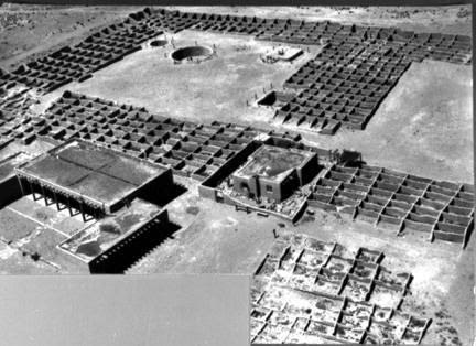
    <title type="html"><![CDATA[The Kuaua Pueblo Ruins and the Coronado Historic Site]]></title>
    <summary type="html"><![CDATA[<p><strong><em>During Francisco Vasquez de Coronado’s expedition to New Mexico in the 1540s, he came into contact with the Tiwa people who lived in pueblos near modern-day Albuquerque. In the 1930s, archaeologists excavated the ruins of Kuaua, one of the largest pueblos. These ruins currently constitute a large part of the Coronado Historic Site.</em></strong></p><img src="https://www.intermountainhistories.org/files/fullsize/abc8c5fc50ca9f4f5d8bae95e244cdb1.jpg" alt="Kuaua ruins, Coronado State Monument, 1940" /><br/><p>Archaeologists located the Kuaua Pueblo ruins just north of Albuquerque, New Mexico along the banks of the Rio Grande River. Created as part of the 400th anniversary of Francisco Vasquez de Coronado’s entry into New Mexico, the Coronado History Site references the expedition’s interactions with local Tiwa villages. Kuaua, a name meaning “evergreen” in Tiwa, was one of the largest of these villages and may have been the site of Coronado’s winter headquarters during the expedition. Archaeologists have estimated that the Tiwa settled this village in the fourteenth century and likely contained more than one thousand people when they came into contact with Coronado. However, conflict over the years with Coronado and other Spanish explorers eventually led to the Tiwa’s abandonment of Kuaua Pueblo in the sixteenth century.</p><p>When the archaeological team excavated the Kuaua Ruins in the 1930s, they uncovered more than 1,200 adobe rooms, three ceremonial rooms, and six kivas. Several of the kivas contained a series of murals that many revere today as some of the best examples of Pre-Columbian artwork in the United States. Kuaua religious murals flourished throughout the fourteenth, fifteenth, and sixteenth centuries, reflecting religious and cosmological iconography such as references to rain, rainbows, clouds, lightning, and ritual figures engaging in rain-making rituals. These rituals formed an important part of Pueblo culture and religion due to the region’s general climate of minimal precipitation. </p><p>Thanks to extensive conservation efforts since the 1930s, the murals have been preserved for modern viewing. The Coronado Historic Site includes a Visitor Center, which features fourteen examples of original mural artwork as well as Pueblo Indian and colonial Spanish artifacts. Several trails throughout the ruins of the pueblo and along the Rio Grande River provide exploration opportunities for visitors wishing to more authentically learn about the Tiwa Pueblo culture and lifestyle.</p><p><em><strong><a href="https://www.intermountainhistories.org/items/show/404">For more (including 3 images) view the original article</a></strong></em></p>]]></summary>
    <published>2020-03-11T22:43:42+00:00</published>
    <updated>2026-04-17T19:32:08+00:00</updated>
    <link rel="alternate" type="text/html" href="https://www.intermountainhistories.org/items/show/404"/>
    <id>https://www.intermountainhistories.org/items/show/404</id>
    <author>
      <name>Sarah Rounsville, Brigham Young University</name>
    </author>
  </entry>
</feed>