<?xml version="1.0" encoding="UTF-8"?>
<feed xmlns="http://www.w3.org/2005/Atom">
  <title type="text">Intermountain Histories</title>
  <updated>2026-04-17T19:32:18+00:00</updated>
  <generator uri="http://framework.zend.com" version="1.12.20">Zend_Feed_Writer</generator>
  <link rel="alternate" type="text/html" href="https://www.intermountainhistories.org/"/>
  <link rel="self" type="application/atom+xml" href="https://www.intermountainhistories.org/items/browse?output=rss2"/>
  <id>https://www.intermountainhistories.org/</id>
  <author>
    <name>Intermountain Histories</name>
    <uri>https://www.intermountainhistories.org</uri>
  </author>
  <link rel="hub" href="https://pubsubhubbub.appspot.com/"/>
  <entry>
    <title type="html"><![CDATA[First National Bank of Joseph]]></title>
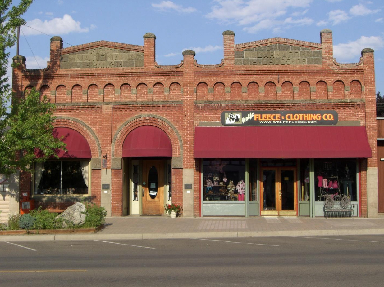
    <summary type="html"><![CDATA[<p><strong><em>The First National Bank of Joseph, established in 1905, served as a vital source for its small but growing population, closing in 1923 in the wake of the economic downturn of 1920-21.</em></strong></p><img src="https://www.intermountainhistories.org/files/fullsize/9fa7e711d5d032c02ee4c62d782180bc.jpg" alt="Exterior view of the First National Bank of Joseph building, 2013" /><br/><p><span style="font-weight:400;">Despite Joseph’s isolated northeastern location in Oregon, retaining a small population of 250 people, it accrued wealth through its farming and ranching industries. In response to this economic growth, a consortium of entrepreneurs established the First National Bank of Joseph in 1905 with $25,000 of capital, offering competition to the First Bank of Joseph, previously the town’s only financial institution. In 1908, profitability proved healthy as assets increased to over $52,000, causing First National’s directors to construct a new building for their operations.</span>
<span style="font-weight:400;">Designed by J.A. Flesch & Sons of Chicago and built by local contractor Frank Marr, Dr. Jerome William Barnard, a local physician, partnered with First National by funding a single building for their businesses, sharing a common interior wall, and saving on construction costs. Around the opening of the new bank building, Joseph experienced a population boom of 206% from 1908-10, after the Oregon-Washington Railroad & Navigation Company connected the town through a branch line linking it to Enterprise, Oregon, located in the state’s northeastern sector, connecting Joseph to a larger economy.</span>
<span style="font-weight:400;">First National’s inaugural president, farmer Ludwig Knapper, one of Wallowa County’s wealthiest entrepreneurs, utilized the bank, along with associates Aaron M. Wade, Charles Leslie Hartshorn, and Joseph Pearne Averill, to pool their wealth and expand Joseph’s economic resources into its growing timber market, the town’s largest commodity. From 1909 to 1919, this syndicate’s investments also included land acquisitions for cattle and sheep raising, a light and power company, a warehouse corporation, as storage for farm products, a woolgrower’s cooperative for sheep raising, and an irrigation organization, which supported farming around the Little Sheep Creek in Wallowa County.</span>
<span style="font-weight:400;">Through these and other enterprises, chiefly through supplying capital or loans to new businesses, First National’s assets considerably increased, reaching $370,000 in 1919, capitalizing on the burgeoning wartime economy. Its influence attracted attention from Frederick Wesley Falconer, one of Wallowa County’s largest sheep farmers and operator of the Enterprise State Bank in Enterprise, Oregon who purchased a controlling interest in First National and became its new president. After Falconer became interested in other financial ventures, he handed the presidency to director Daniel Welbaum Warnock, a notable rancher and blacksmith, in 1921.</span>
<span style="font-weight:400;">Despite the bank’s profitability, the economic downturn of 1920-1 facilitated First National's decline. While it retained a healthy surplus, its creditors consisted primarily of farmers and ranchers, who because of rising inflation and declining wartime demands, became unable to pay interest on their loans, freezing repayments and eliminating most of First National’s income. While the national economy quickly rebounded in 1922, Joseph’s conditions stagnated. First National’s directors ceased operation in June 1923 in the interest of their clients, redistributing any remaining deposits.</span>
<span style="font-weight:400;">In 1925, the bank building became the Joseph Post Office, serving in this capacity until 1960, and housed commercial businesses into the 1980s. By this period, the facility fell into disrepair and underwent restoration to its original appearance and accommodated an art gallery. Currently, it accommodates Heidi’s Towne Shop, a local boutique and clothing store.</span></p><p><em><strong><a href="https://www.intermountainhistories.org/items/show/810">For more (including 6 images) view the original article</a></strong></em></p>]]></summary>
    <published>2024-05-20T23:14:19+00:00</published>
    <updated>2026-04-17T19:32:18+00:00</updated>
    <link rel="alternate" type="text/html" href="https://www.intermountainhistories.org/items/show/810"/>
    <id>https://www.intermountainhistories.org/items/show/810</id>
    <author>
      <name>William R. Batson, Northern Arizona University</name>
    </author>
  </entry>
  <entry>
    <title type="html"><![CDATA[Kam Wah Chung &amp; Co. ]]></title>
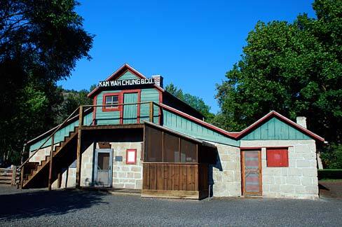
    <summary type="html"><![CDATA[<p><strong><em>In the 19th century, the United States rapidly expanded West. This expansion was expedited by the discovery of gold in the western mountains. Along with it came an influx of Chinese workers. As anti-Chinese sentiment festered during the latter half of the century, a medicine shop rose to prominence in John Day, Oregon.</em></strong></p><img src="https://www.intermountainhistories.org/files/fullsize/5bc7a3df9efef6793d330b545baa0691.jpg" alt="Kam Wah Chung Museum" /><br/><p><span style="font-weight:400;">Along the Dalles Military Road sits the small town of John Day, Oregon. In the mid-1860s, a Chinatown hub for the Chinese miners and immigrants emerged in the area. A small wooden building purchased by Ing Hay and Lung On served as the foundation for a business with—at the time—no promises for future success.</span> <span style="font-weight:400;">Ing Hay was both an herbalist and pulsologist, diagnosing patients based on their pulse. Born in 1862, he sought better fortunes in the Western United States in 1887. In John Day, Oregon, he met Lung On and purchased the dying Kam Wah Chung & Co. Locally known as “Doc” Hay, he treated a variety of ailments with traditional Chinese remedies based on Taoist teachings of harmony and balance. His clientele diversified and included more non-Chinese patients through the 1910s. </p> <span style="font-weight:400;">Lung On, on the other hand, was a savvy businessman fluent in both Chinese and English. He was also a Chinese immigrant and managed the business side of Kam Wah Chung which included pricing, inventory, translating and responding to letters. Locally known as “Leon”, he owned, co-owned, and invested in numerous other operations around Oregon, including businesses, land and mining claims, racehorses, and later an automotive dealership. He also provided a letter-writing service and assistance in navigating American laws for Chinese migrants and immigrants.</p> <span style="font-weight:400;">Together, the two transformed Kam Wah Chung & Co. into a successful mercantile, apothecary, and clinic. It also served as an education and community center. Kam Wah Chung served as an anchor for the surrounding Chinese community and a bridge for non-Chinese neighbors during an era of heightened anti-Chinese sentiment. This success continued into the early 20th century until Lung On’s death in 1940. Ing “Doc” Hay moved to Portland in 1948 due to failing health. The Kam Wah Chung & Co. has been converted into a museum that houses a plethora of Lung On’s untranslated ledgers and documents, Chinese medicinal recipes from Ing Hay’s days of practice, and records of the significant footprint Hay and On left on western U.S. history.</span>
<i><span style="font-weight:400;">Friends Of Kam Wah Chung, </span></i><span style="font-weight:400;">a non-profit organization, continues to research, translate, and excavate the cultural artifacts left behind in John Day. More information about current research and the museum can be found on their website, and much of their work is available to the public. Kam Wah Chung is now a state park and National Historical site.</span></p><p><em><strong><a href="https://www.intermountainhistories.org/items/show/743">For more (including 6 images) view the original article</a></strong></em></p>]]></summary>
    <published>2023-04-10T19:33:02+00:00</published>
    <updated>2026-04-17T19:32:16+00:00</updated>
    <link rel="alternate" type="text/html" href="https://www.intermountainhistories.org/items/show/743"/>
    <id>https://www.intermountainhistories.org/items/show/743</id>
    <author>
      <name>Emma Dutcher, Brigham Young University</name>
    </author>
  </entry>
  <entry>
    <title type="html"><![CDATA[Hells Canyon Dam]]></title>
    <summary type="html"><![CDATA[<p><strong><em>Straddling the Idaho–Oregon border and holding firm to the walls of Hells Canyon, the Hells Canyon Dam provides hydroelectric power and irrigation channels to surrounding localities. A creation of the Idaho Power Company, the concrete dam is one of three in the Hells Canyon Complex, the largest privately-owned hydroelectric power complex in the nation, whose motivations and consequences can be felt politically and ecologically.</em></strong></p><img src="https://www.intermountainhistories.org/files/fullsize/010642938f4450485d7ddd6aff0409f0.jpg" alt="Damming Hells Canyon" /><br/><p>The Hells Canyon Complex was controversial before even being built, ever since the Idaho public scrutinized the Idaho Power Company’s request to license three dams on the Snake River in 1947. During the New Deal era, public power—a method of energy administration defined in which communities owned infrastructure under local government—was the norm for hydroelectricity; while Idaho Power wanted to privately run three dams, advocates for public power in the region instead contended against Idaho Power in favor of establishing a single, high dam. After a long battle, private power won when the Federal Power Commission issued Idaho Power a license in 1955, allowing them to build a private hydroelectric complex, in turn signaling a decline of public power’s favor nationwide. Due to the Hells Canyon dam construction in the deepest gorge on the North American continent, the construction process proved difficult, and builders had to dig a twenty-three-mile access road into the Idaho side of the canyon. Along with the road, contractors set up offices, facilities, housing, and a mess hall for construction workers. In a matter of six months, the Hells Canyon Dam’s construction was complete in 1967, and it began generating electricity shortly after.
The political controversy in the postwar years about whether hydropower was something to be publicly or privately owned has roots deep in the ecological. The Hells Canyon Complex sits on the Snake River Basin, a desert ecosystem, while many of the models that public ownership advocates used were based on dams built on the Columbia River Basin, which was forested and mountainous. Because of the ecological differences inherent to these basins, people interacted differently with these water systems, and as a result, their priorities varied in what services a dam should provide. In the Columbia Basin, priority was given to energy production, while in the Snake Basin, priority was given to irrigation. This is largely due to the relationship people had with the land. In the Snake Basin, people cultivated the land for crop harvest, so they wanted the Hells Canyon Complex to have irrigation as its chief operating principle. This gave wind to Idaho Power’s licensing for the three Snake River dams; a single high dam would better serve power generation, but Idaho Power contended that the three-dam complex better served irrigation.
While ecology shaped Hells Canyon Dam, the dam also reshaped the environment. By its very design, the Hells Canyon Complex has no passage for andronomous fish species, a type of fish that migrates from freshwater to the ocean in the Snake and Columbia Rivers. Limiting certain fish species’ ability to access any of the upper Snake River Basin between the complex to Shoshone Falls has dramatically reduced the species’ population and disturbed several ecosystems. This can be traced back to the general neglect of biological research before the construction of dams along the Columbia and Snake Rivers.</p><p><em><strong><a href="https://www.intermountainhistories.org/items/show/627">For more (including 3 images) view the original article</a></strong></em></p>]]></summary>
    <published>2022-06-30T19:53:46+00:00</published>
    <updated>2026-04-17T19:32:13+00:00</updated>
    <link rel="alternate" type="text/html" href="https://www.intermountainhistories.org/items/show/627"/>
    <id>https://www.intermountainhistories.org/items/show/627</id>
    <author>
      <name>Hunter Marang, College of Idaho</name>
    </author>
  </entry>
  <entry>
    <title type="html"><![CDATA[Abel E. Eaton House]]></title>
    <summary type="html"><![CDATA[<p><strong><em>Owned by a schoolteacher turned industrialist, the Abel E. Eaton House remains an unusual but attractive example of Second Empire architecture in Oregon.</em></strong></p><img src="https://www.intermountainhistories.org/files/fullsize/781b69d9143d6aecf6a39c04d172878f.jpg" alt="Enclosed porch" /><br/><p>Union, Oregon began as an industrial town in 1862, serving as one of the state’s primary economic centers through the end of the nineteenth century. Abel Elsworth Eaton, a former schoolteacher in the Midwest, moved to Oregon seeking financial gain, and he opened a successful freighting business in Baker City in 1867. He eventually purchased a woolen mill in neighboring Union in 1871. When the mill became his primary business, he moved to the town permanently and started a ranch in the area. Because of these and other financial interests, Eaton developed a considerable fortune and decided to build a home equivalent to his status in 1908, culminating in the Abel E. Eaton House. He combined two ornamental architectural styles, the waning Second Empire style with the more popular Queen Anne style, to create an unusual but appealing structure.
Queen Anne style bears similarities to Second Empire as it often contains high amounts of interior and exterior decoration, though it follows eighteenth-century <em>British</em> design cues instead of French ones. Instead of Second Empire mansard roofs, which distinctly curve downward from a square or rectangular top, Queen Anne roofs are gabled, sloping downward on the front and back, leaving a gable (the wall) in between the roof’s sides. Steeply pitched roofs are common on Queen Anne structures, creating the perception of a larger home, while Second Empire ones are symmetrical, curving down from the flat top on four sides, providing more space in the second story. The Eaton House combines these two designs, as its roof is mansard, but steeply pitched, including several smaller roofs in front of the second-story balconies and windows, expanding with the exterior walls.
Unlike many Second Empire and Queen Anne houses, the Eaton House does not embrace ornamentation, remaining plain, but tasteful. While elegant in appearance, it is not large and is slightly under 1,500 square feet, though it contains five bedrooms and two-and-a-half bathrooms. Its simple brick siding, however, is broken by the classically-inspired wraparound porch. This feature, often found in Queen Anne style, makes homes seem larger in scale and provides greater exterior variety. In another contradiction, ornamental cast-iron fencing, typical in Second Empire homes, tops the section of the roof curved in the shape of a bell, known as a bellcast tower, above the balconies.
The Eaton House remains well-preserved, with the floor plan unchanged, staying close to the condition Eaton left it when he died in 1917. Before his passing, Eaton served as Mayor of Union for one term and unsuccessfully ran for governor under the Prohibition ticket in 1910, winning 5.1% of the vote. The only major adjustment to this house after his death is the alternation of the wraparound porch. Previously enclosed by large windows in-between classical pillars, the entrance has since been exposed, showing the front door and exterior brickwork. Without older photographs of the Eaton House, this change would be almost unnoticeable, as the open-air entrance appears natural. Listed on the National Register of Historic Places in 1977, the Eaton House remains private property at the time of writing and is not open to the public.</p><p><em><strong><a href="https://www.intermountainhistories.org/items/show/595">For more (including 5 images) view the original article</a></strong></em></p>]]></summary>
    <published>2022-04-16T04:41:33+00:00</published>
    <updated>2026-04-17T19:32:13+00:00</updated>
    <link rel="alternate" type="text/html" href="https://www.intermountainhistories.org/items/show/595"/>
    <id>https://www.intermountainhistories.org/items/show/595</id>
    <author>
      <name>William R. Batson, Northern Arizona University</name>
    </author>
  </entry>
  <entry>
    <title type="html"><![CDATA[Jean-Baptiste Charbonneau’s Grave]]></title>
    <summary type="html"><![CDATA[<p><strong><em>Born in February 1805, Jean-Baptiste Charbonneau accompanied the Lewis and Clark Expedition as an infant before becoming a fur trader, guide, alcalde, and then a hotel manager in California.</em></strong></p><img src="https://www.intermountainhistories.org/files/fullsize/01db17a0c012fd0f8a8d4751a3066439.jpg" alt="Charbonneau gravesite" /><br/><p>Jean-Baptiste Charbonneau, son of Sacagawea and Toussaint Charbonneau, accompanied his parents on Meriwether Lewis and William Clark’s expedition for the Corps of Discovery. Although a small infant, he made the entire trek from North Dakota to the Pacific Coast and back to the Mandan Villages on the Knife River. After Sacagawea’s death in December 1812, William Clark legally adopted Jean-Baptiste and his little sister Lisette. Clark provided an education for the two children at a Catholic boarding school in St. Louis. This education opened up numerous opportunities for Jean-Baptiste throughout his life.
As an adult, Jean-Baptiste spent a substantial amount of time in Europe where he learned additional languages and skills. Returning to America, he joined the fur trade, working as a trapper with the Rocky Mountain Fur Company. His extensive knowledge of the terrain enabled him to serve as a guide for explorers, as well as for the Mormon Battalion on their route from Leavenworth to San Diego in 1846 during the Mexican–American War.
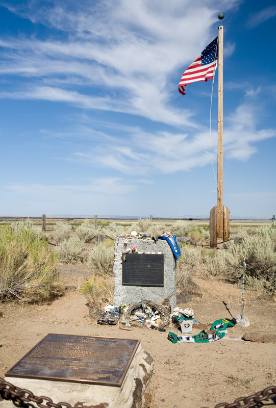
While in California, Charbonneau worked as an alcalde (mayor), panned for gold, provided interpretation services, and operated a hotel in Auburn, California. After the American Civil War and toward the end of his life, Charbonneau worked odd jobs until he learned about gold and silver strikes in Idaho and Montana. On his way to the mining rushes he traveled through Danner, Oregon, but shortly after crossing the Jordan Creek and the Owyhee River, he fell ill (likely of pneumonia) and died at sixty-one years old. Oregonians memorialized Charbonneau by erecting and dedicating a plaque to him in Danner. His place of death is located just over the border of Oregon and is close to the Lemhi Shoshone Nation of Idaho, the likely birthplace of his mother, Sacagawea.</p><p><em><strong><a href="https://www.intermountainhistories.org/items/show/585">For more (including 3 images) view the original article</a></strong></em></p>]]></summary>
    <published>2022-04-09T07:02:41+00:00</published>
    <updated>2026-04-17T19:32:12+00:00</updated>
    <link rel="alternate" type="text/html" href="https://www.intermountainhistories.org/items/show/585"/>
    <id>https://www.intermountainhistories.org/items/show/585</id>
    <author>
      <name>Taylor Mansfield, Brigham Young University</name>
    </author>
  </entry>
  <entry>
    <title type="html"><![CDATA[Fort Hall: Nathaniel J. Wyeth’s Snake River Outpost]]></title>
    <summary type="html"><![CDATA[<p><strong><em>Nathaniel J. Wyeth established a fort along the Snake River that acted as a significant military and economic waypoint to the American West. Even after passing from his hands, the fort maintained its strategic and even religious significance.</em></strong></p><img src="https://www.intermountainhistories.org/files/fullsize/2b5558685da96adff0223558e857869c.jpg" alt="Fort Hall replica" /><br/><p>Boston inventor and businessman Nathaniel J. Wyeth conducted two separate expeditions to the Pacific Northwest in 1832 and 1834 with his Columbia River Fishing and Trading Company. On his latter expedition, Wyeth established a fort in what is now Idaho and named it after his traveling partner, Hall J. Kelly. While the longevity of Wyeth’s company was limited, Fort Hall stood as an essential location for the military, Oregon Trail, and California Tsrail for decades. Its replica now stands as a long-lasting monument to the Rocky Mountain fur trade and mountain man era of the 1830s.
Located at the future junction of the California and Oregon overland trails, Fort Hall transitioned from a fur trade post to a vital resupply destination for American overlanders, Indigenous peoples, and fur traders alike. In a letter to his uncle Jarvis on October 6, 1834, Wyeth described the fort: “Its Bastions stand a terror to the sculking Indian and a beacon of saf[e]ty to the fugitive hunter.”
Even after the fort was sold to the Hudson Bay Company in 1836, and later purchased by the U.S. military, it remained an important landmark for the next 80 years. Its significance came as no surprise to Wyeth. Its strategic location on the Snake River made it an ideal spot for transferring supplies and for troop garrisons on the frontier. In his statement of facts concerning the sale of the fort he wrote: “disposing of the property to the best advantage. All the property in the interior including Fort Hall was sold, it being necessary to retain that post, to keep up a garrison for its defense against the Indians, and to forward annual supplies to it, an operation at that time beyond our means.”
What made Fort Hall especially unique to the history of American expansionism was the presence of Protestant American missionaries. While many European powers had colonized through religion, this was one of the first official ecumenical efforts to spread religious beliefs in this American region. This exemplified how Manifest Destiny envisioned expansion not only economically, but also religiously, as America established its presence as a power on the frontier.
There are only seven American-built forts along the Oregon Trail. Each stand as a legacy to American expansion. While Nathaniel Wyeth only maintained the fort for two years, the fort was built on principles which came to define America as a nation.</p><p><em><strong><a href="https://www.intermountainhistories.org/items/show/580">For more (including 3 images) view the original article</a></strong></em></p>]]></summary>
    <published>2022-03-12T10:30:23+00:00</published>
    <updated>2026-04-17T19:32:12+00:00</updated>
    <link rel="alternate" type="text/html" href="https://www.intermountainhistories.org/items/show/580"/>
    <id>https://www.intermountainhistories.org/items/show/580</id>
    <author>
      <name>Ruth Hardy, Brigham Young University</name>
    </author>
  </entry>
  <entry>
    <title type="html"><![CDATA[Land Claims in Malheur National Wildlife Refuge]]></title>
    <summary type="html"><![CDATA[<p><strong><em>Northern Paiute tribes have long struggled for the right to use their ancestral homelands in Malheur National Wildlife Refuge and its surrounding basin. Yet the Paiute people are not the only group who feel they have a right to the land, and the now-infamous Oregon militia occupation of the refuge in 2016 has sparked further conversations about the importance of land repatriation.</em></strong></p><img src="https://www.intermountainhistories.org/files/fullsize/c51a6682c39eab1642916d4143f1a27d.jpg" alt="Buena Vista Overlook at Malheur" /><br/><p>Like many areas in the continental United States and beyond, human presence in Malheur National Wildlife Refuge spans not hundreds of years but thousands. Though steady environmental changes altered the land’s usage over time (mainly the rise and fall of water levels in the Malheur and Harney Lakes), Paiutes’ connection to the land never diminished. Resource gathering remained constant as tribal members passed their cultural knowledge across generations, and the Paiute people continually returned to build new living centers. However, the arrival of fur trappers in the nineteenth century complicated this long-standing relationship with the land, and explorers identified the region not as one of plenty, but as one of <em>malheur</em>, French for misfortune. Paiute bands roamed the territory freely alongside these fur trappers until the creation of Malheur Indian Reservation in 1872.
In addition to fur trading, plume hunters in the 1880s began to hunt the regions’s white herons for their feathers. When photographers William L. Finley and Herman T. Bohlman recognized the dismal state of their population, the two rallied for the creation of a refuge to protect the birds’ habitats. They got their wish in 1908 when President Roosevelt signed the Malheur National Wildlife Refuge into existence, creating one of the earliest wildlife refuges west of the Mississippi. Since then, Malheur has protected the homes of not only white herons but other bird species in the area.
Decades of homesteading have had their impact on the land, however, and many people still call the surrounding areas home. Beginning in the 1900s, the Bureau of Land Management began to issue cattle grazing permits in the area. However, the jurisdiction of the federal government did not sit well with many ranchers. One pair of cattle ranchers, father and son Dwight and Steven Hammond, was convicted of repeated arson on refuge lands in 2012. A later order for them to return to prison would spark a national incident in 2016.
The militia occupation of Malheur Refuge had many inciting factors, including the emboldening white nationalism in Donald Trump’s presidential campaign. Frustration with the federal government had long been present in the area, mainly from farmers and ranchers who felt they lacked adequate access to grazing land. Such frustrations were and are hardly unique in the United States West, and certainly not in Oregon. This entitlement, however, overlooks a similar loss of access—one that the Northern Paiute have faced for far longer. Forcefully evicted from their land, the Paiute fought for their treaty rights in the 1870s only for the government to forcefully relocate them to the Yakama Reservation in 1879. The recent Malheur occupation sparked discussions of land repatriation among the Paiute, something owed for far too long, bringing attention to the nationwide indigenous #LandBack movement, which aims to remove land rights from federal and private colonizers’ control. In many ways, Malheur shows the myriad disconnections between living the land, owning the land, and respecting the land.</p><p><em><strong><a href="https://www.intermountainhistories.org/items/show/547">For more (including 6 images) view the original article</a></strong></em></p>]]></summary>
    <published>2021-12-17T02:11:13+00:00</published>
    <updated>2026-04-17T19:32:11+00:00</updated>
    <link rel="alternate" type="text/html" href="https://www.intermountainhistories.org/items/show/547"/>
    <id>https://www.intermountainhistories.org/items/show/547</id>
    <author>
      <name>Len Truelsen, Northern Arizona University</name>
    </author>
  </entry>
</feed>