<?xml version="1.0" encoding="UTF-8"?>
<feed xmlns="http://www.w3.org/2005/Atom">
  <title type="text">Intermountain Histories</title>
  <updated>2026-08-18T15:52:34+00:00</updated>
  <generator uri="http://framework.zend.com" version="1.12.20">Zend_Feed_Writer</generator>
  <link rel="alternate" type="text/html" href="https://www.intermountainhistories.org/"/>
  <link rel="self" type="application/atom+xml" href="https://www.intermountainhistories.org/items/browse?output=rss2"/>
  <id>https://www.intermountainhistories.org/</id>
  <author>
    <name>Intermountain Histories</name>
    <uri>https://www.intermountainhistories.org</uri>
  </author>
  <link rel="hub" href="https://pubsubhubbub.appspot.com/"/>
  <entry>
    <title type="html"><![CDATA[Theodore Roosevelt and the Havasupai in the Grand Canyon: Story 2 of 8 of the President Theodore Roosevelt in the West Tour]]></title>
    <summary type="html"><![CDATA[<p><strong><em>President Theodore Roosevelt visits the Grand Canyon meeting the Havasupai Tribe. His efforts are making this landmark a National Park.</em></strong></p><img src="https://www.intermountainhistories.org/files/fullsize/81adde6a6a5c04daf97ec29b93d422ee.jpg" alt="Down a winding pathway, Theodore Roosevelt and others ride mules down Bright Angel Trail in the Grand Canyon" /><br/><p>Theodore Roosevelt traveled over 14,000 miles, visiting over 25 states, in the span of nine weeks in the early summer of 1903. His western tour was filled with speeches, commemorations, and his favorite thing to do: exploring the outdoors. His tours of Yosemite and Yellowstone are widely known, but in between them, he visited the Grand Canyon on May 6, 1903. He said, giving a speech, “In the Grand Canyon, Arizona has a natural wonder which, so far as I know, is absolutely unparalleled throughout the rest of the world.” Astounded, he said, “I shall not attempt to describe it, because I cannot. I could not choose words that would convey or that could convey to any outsider what that canyon is.” The majesty of Earth’s beauty there led him to explore more.
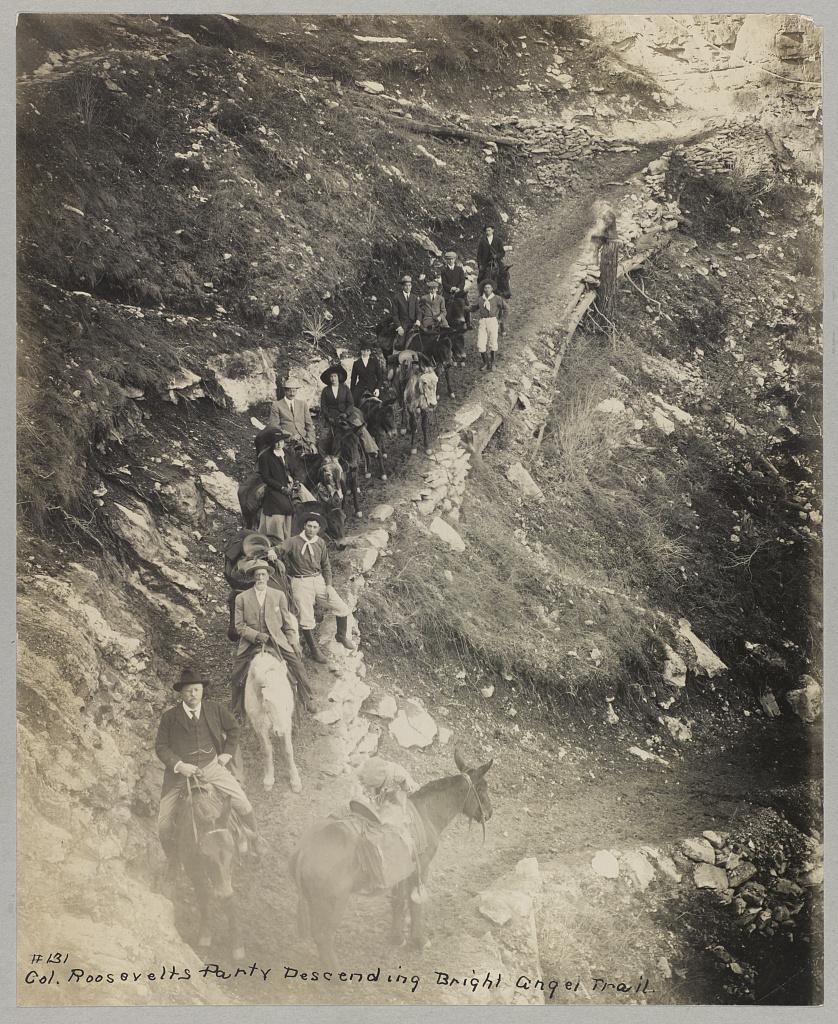
Riding a mule down Bright Angel Trail, he met two natives from the Havasupai tribe who lived in the Indian Garden with their families. For 1,000 years, the tribe lived in this region without outside contact, until Spanish priest Francisco Garces explored the area in 1776. As a result of the Santa Fe Railroad in the early 18th century, the Havasupai had increasingly more contact with other explorers and settlers. When Roosevelt and his regiment visited, he asked them to leave to make the canyon a National Park. To gain the status of a national park, all private development on the land would be illegal according to Congress. This resulted in the Havasupi’s relocation to a 518-acre reservation in Havasu Canyon instead.
Roosevelt was also concerned about the commercialization and exploitation of the land due to encroaching mining and timber interests. On June 8th, 1906, he signed the Antiquities Act, which authorized the president to “declare by public proclamation historic landmarks, historic and prehistoric structures, and other objects of historic or scientific interest that are situated upon the lands owned or controlled by the Government of the United States to be national monuments.” Subsequently, this act was used to establish the Grand Canyon National Monument on January 11th, 1908. It was made a National Park in 1919. Roosevelt Point and Trail were named in the President’s honor for the efforts he provided. A placard at Roosevelt Point reads another part from his speech advocating one request, “Leave it as it is. You can not improve on it. The ages have been at work on it, and man can only mar it. What you can do is to keep it for your children, your children's children, and for all who come after you, as one of the great sights which every American, if he can travel at all, should see.” Poetically, he wrote a letter to John Hay, former Secretary of State, summing up his experience on his Western tour and paying special attention to the Grand Canyon, “To me the most impressive piece of scenery I have ever looked at. I don’t exactly know what words to use in describing it. It is beautiful and terrible and unearthly. It made me feel as if I were gazing at a sunset of strange and awful splendor.” Today, almost 5 million tourists continue to explore this canyon that Roosevelt cared so profoundly to preserve.</p><p><em><strong><a href="https://www.intermountainhistories.org/items/show/924">For more (including 4 images) view the original article</a></strong></em></p>]]></summary>
    <published>2025-10-24T15:03:19+00:00</published>
    <updated>2026-08-18T15:52:34+00:00</updated>
    <link rel="alternate" type="text/html" href="https://www.intermountainhistories.org/items/show/924"/>
    <id>https://www.intermountainhistories.org/items/show/924</id>
    <author>
      <name>Jessika Cole, Brigham Young University</name>
    </author>
  </entry>
  <entry>
    <title type="html"><![CDATA[Teddy Roosevelt and John Muir Adventures in Yosemite: Story 3 of 8 of the President Theodore Roosevelt in the West Tour]]></title>
    <summary type="html"><![CDATA[<p><strong><em>President Theodore Roosevelt and his guide John Muir explored California’s beautiful National Park, Yellowstone, resulting in a nationwide conservation effort. </em></strong></p><img src="https://www.intermountainhistories.org/files/fullsize/091739d27efed8fc403fa07e54012ffd.jpg" alt="Theodore Roosevelt and John Muir pose in front of Glacier Point at Yosemite" /><br/><p>With a fondness for adventure, the outdoors, and the American West, President Theodore Roosevelt itched to experience the natural landscapes in California he’d heard so much about. Yosemite was one of only two national parks at the turn of the century, and he felt it fitting to include that stop in his 1903 Western tour. Roosevelt wrote a letter to John Muir, a Scottish botanist and conservationist who caught the President’s attention with his non-fiction novel “Our National Parks,” and asked him to be his guide. “I do not want anyone with me but you, and I want to drop politics absolutely for four days and just be out in the open with you.” Muir had an overseas journey planned in Europe and Asia at that time that he didn’t think he could cancel. After explaining the situation to the President of the University of California, Benjamin Ide Wheeler, he got an appeal and joined Roosevelt in the mountains, “I might be able to do some forest good in freely talking around the campfire,” Muir mused. As per Roosevelt’s request, politics were not discussed, but Muir’s agenda was nonetheless accomplished: to advocate for the land in the American West.
Roosevelt and his contingent arrived at Yosemite’s Wawona Hotel on May 15, 1903. With others remaining there, Muir, Roosevelt, a cook, two packers, and four mules left for the trees. They traveled through the giant sequoias, wandered through Mariposa Grove in the valley, and one night after camping at Glacier Point, they woke up to a blanket of snow, five inches atop them. If Roosevelt didn’t have forty wool blankets his men laid down for him and a warm fire by his side, he would have froze! Nonetheless, the men had great conversations. Charles Leidig was the cook and documented that “they talked a great deal about the conservation of forests in general and Yosemite in particular.” He also said, “he heard them discussing the setting aside of other areas in the United States for park purposes.” Muir had, indeed, done the “forest good.”
This trip jump-started Roosevelt's efforts to preserve public lands and natural resources across the nation. He was impressed to immediately go to Congress when returning to Washington and implement some of Muir’s ideas. He pushed for wildlife reserves, and on June 8, 1906, he signed the Antiquities Act which allowed the President to “declare by public proclamation historic landmarks” to be “national monuments, and may reserve as a part thereof parcels of land, the limits of which in all cases shall be confined to the smallest area compatible with proper care and management of the objects to be protected.” Roosevelt famously said in a speech in Sacramento after his experience in Yosemite, “We are not building this country for a day. It is to last through the ages.” Yosemite laid the groundwork for protecting other national forests in California and across the nation.</p><p><em><strong><a href="https://www.intermountainhistories.org/items/show/921">For more (including 3 images) view the original article</a></strong></em></p>]]></summary>
    <published>2025-10-24T15:03:18+00:00</published>
    <updated>2026-08-18T15:52:06+00:00</updated>
    <link rel="alternate" type="text/html" href="https://www.intermountainhistories.org/items/show/921"/>
    <id>https://www.intermountainhistories.org/items/show/921</id>
    <author>
      <name>Jessika Cole, Brigham Young University</name>
    </author>
  </entry>
  <entry>
    <title type="html"><![CDATA[Yellowstone’s Favorite President’s Monument: Roosevelt Arch: Story 1 of 8 of the President Theodore Roosevelt in the West Tour]]></title>
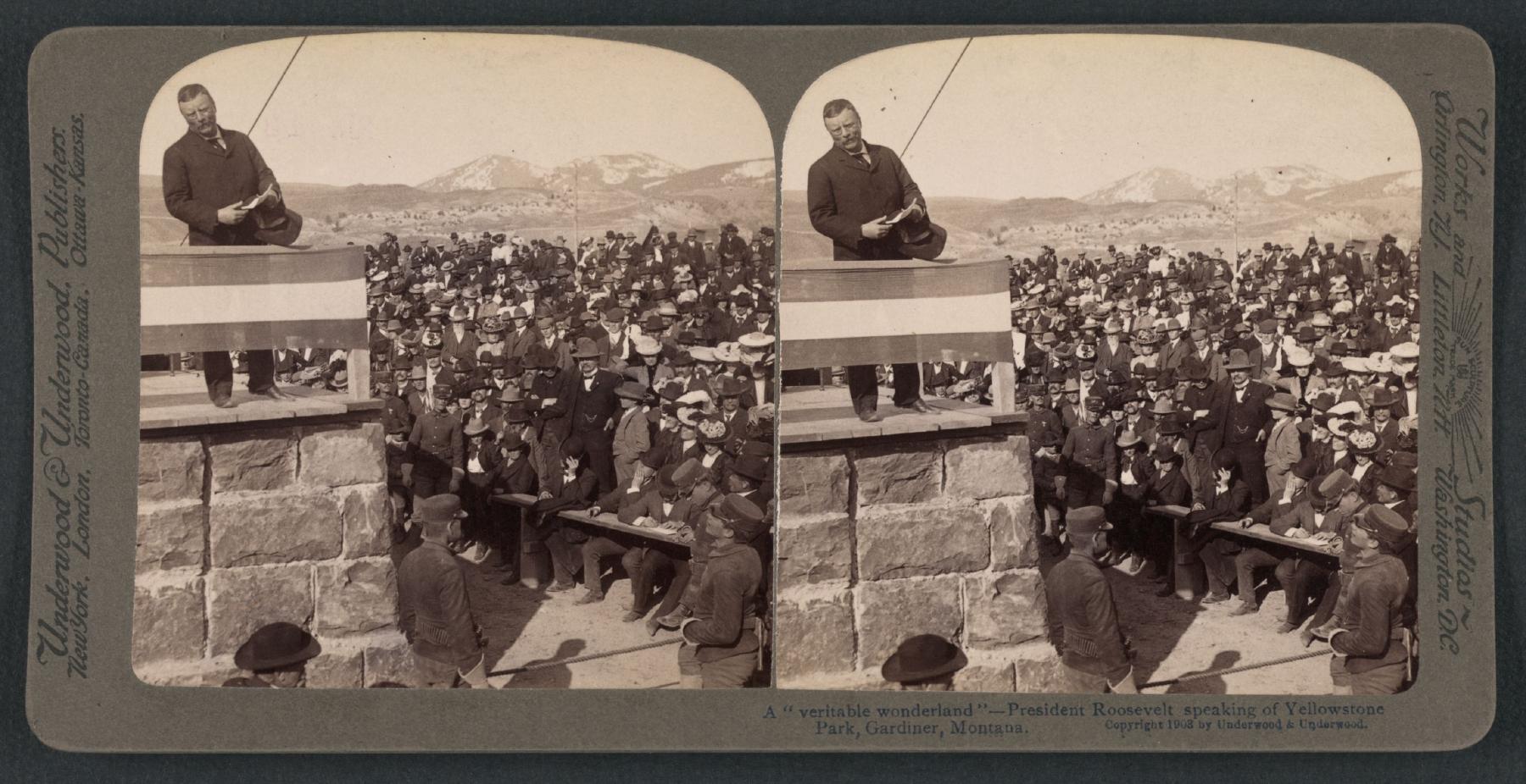
    <summary type="html"><![CDATA[<p><strong><em>Yellowstone receives an upgraded welcome with the Roosevelt Arch and gets a surprise visitor, Theodore Roosevelt, to dedicate it. </em></strong></p><img src="https://www.intermountainhistories.org/files/fullsize/f5ae52940338461ed18d1b83497abbb0.jpg" alt="President Roosevelt addresses a crowd at the dedication of Roosevelt Arch" /><br/><p>“Dedicated and set apart as a public park or pleasuring-ground for the benefit and enjoyment of the people.” Roosevelt Arch is a hearty welcome on the North entrance side of Yellowstone National Park. Standing at 52 feet, this monument is a symbol ofthe cultural and natural significance of the Park. Erected in 1903, the arch spanned what was at the time the park’s only entrance. Visitors passed under the arch from Gardiner, Montana, taking stagecoaches into Yellowstone. Army Co Engineer, Hiram M. Chittenden, the idea man, said, “...the natural features of the country at this portion of the boundary are about the least interesting of any part of the Park, and the first impression of visitors upon entering the Park was very unfavorable.” Accordingly, he proposed the arch as a beautiful park entry. Construction began on February 19, 1903 and a dedication ceremony was planned for April 24, 1903 to coincide with Roosevelt's planned visit to the park.</p><p>Yellowstone Park officials asked Roosevelt to participate in the event. This was a perfect opportunity for his conservation efforts and love for the park. With great fanfare, Roosevelt shared, “The geysers, the extraordinary hot springs, the lakes, the mountains, the canyons, and cataracts unite to make this region something not wholly to be paralleled elsewhere on the globe.” His love for the land was shared with the visitors there. They added a time capsule in the arch containing local newspapers, a bible, Masonic documents, a picture of President Roosevelt, and U.S. coins, among other items.
Roosevelt Arch still stands as a ceremonial welcoming committee to Yellowstone. Although not as popular as it was in the 20th century because of changing traffic patterns, automobiles couldn’t take the route like stagecoaches had, it is still a valuable spot to visit when exploring the park. Multiple entrances being added make this an out-of-the-way stop for those accessing the park from the more popular southern and western entrances. Yellowstone is visited by approximately 4 million people annually, and the arch continues to be a popular destination, especially for those visiting the Mammoth area or arriving from points north. It was added to the National Register of Historic Places in 2002 and is a potent symbol and reminder that National parks are “For the benefit and enjoyment of the people” as Theodore Roosevelt referenced the Act Congress passed in 1872 making Yellowstone a public park in his speech, and is not engraved on a place at the top of the arch itself.</p><p><em><strong><a href="https://www.intermountainhistories.org/items/show/919">For more (including 4 images) view the original article</a></strong></em></p>]]></summary>
    <published>2025-10-24T15:03:17+00:00</published>
    <updated>2026-08-18T15:51:51+00:00</updated>
    <link rel="alternate" type="text/html" href="https://www.intermountainhistories.org/items/show/919"/>
    <id>https://www.intermountainhistories.org/items/show/919</id>
    <author>
      <name>Jessika Cole, Brigham Young University</name>
    </author>
  </entry>
  <entry>
    <title type="html"><![CDATA[1988 Fire Season, Yellowstone National Park]]></title>
    <summary type="html"><![CDATA[<p><strong><em>Starting in the 1970s, Yellowstone National Park experimented with a policy that allowed natural fires to burn within park boundaries. In 1988, a series of highly destructive wildfires put this policy to the test, leading to a comprehensive review of the National Park Service’s fire management procedures. </em></strong></p><img src="https://www.intermountainhistories.org/files/fullsize/cbe39d48527aa1fc2d28fe58044f461b.jpg" alt="Wildfire smoke behind Old Faithful Lodge, 1988" /><br/><p>In 1972, the United States National Park Service (NPS) adopted Yellowstone National Park’s first fire management plan, which allowed natural fires to burn in designated parts of the park. In 1976, a revised plan expanded this controversial approach, called prescribed natural fire or the “let-burn” policy, to impact the entire park. Historically, fires played a key role in thinning forests and clearing dry, dead plants from the landscape, and species like lodgepole pine trees rely on extreme heat from fires to release their seeds and reproduce. In theory, prescribed natural burning maintained these conditions and controlled the damage fires caused. While smoke pollution from let-burn events caused controversy throughout the 1970s, they scorched only 34,175 of Yellowstone's 2,221,800 acres between 1977 and 1988. The Park Service extinguished any fires that threatened people, buildings, or roads.
In the summer of 1988, dry weather and high winds created dangerous conditions in Yellowstone. On June 14, 1988, lightning sparked the Storm Creek Fire just north of the park near Cooke City, Montana, and it gradually made its way into Yellowstone’s boundaries. Initially, NPS allowed about twenty lightning-caused fires, including Storm Creek, to burn in every corner of Yellowstone. Without rainfall to dampen their impact, wind spread the fires rapidly. By July 15, the Park Service suspended the let-burn policy and fought every fire that threatened the park.
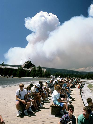
The public idolized Yellowstone as the first national park and a crown jewel of the park system, so the 1988 fires rapidly generated a significant media presence in Yellowstone and caused public backlash. By August, the Cable News Network (CNN) and National Broadcasting Company (NBC) sent reporters to the park and presented daily fire updates. When the largest blaze in the park, the North Fork Fire, threatened the historic Old Faithful Inn on September 7, reporters and their viewers blamed NPS officials and the let-burn policy for allowing the fires to spread out of control. A week later, presidential candidate Michael Dukakis visited the park to generate publicity for his campaign, symbolizing the fires’ grip on national media.
             When snow finally ended the fires in November, fifty-one total fires had burned 995,000 acres, damaging about forty-five percent of the park. They destroyed sixty-seven structures in total, including thirty-six privately owned homes, garages, and stores. The North Fork Fire alone scorched approximately 495,000 acres. After the fires, two review committees found that they represented a perfect storm of natural conditions that made them incredibly difficult to fight, but politicians and the media continued to place blame on NPS management strategies. On July 12, 1989, the Park Service began a systematic review of its fire management procedures. Its new policy, approved in 1991, set detailed limits on the prescription and containment of natural fires, rolling back much of the let-burn approach. Firefighters still use prescribed burns and let-burn management to maintain healthy forests in national parks today, sustaining the 1991 policy.</p><p><em><strong><a href="https://www.intermountainhistories.org/items/show/917">For more (including 4 images) view the original article</a></strong></em></p>]]></summary>
    <published>2025-09-23T15:39:30+00:00</published>
    <updated>2026-04-17T19:32:21+00:00</updated>
    <link rel="alternate" type="text/html" href="https://www.intermountainhistories.org/items/show/917"/>
    <id>https://www.intermountainhistories.org/items/show/917</id>
    <author>
      <name>Kaylen Wilson, Northern Arizona University </name>
    </author>
  </entry>
  <entry>
    <title type="html"><![CDATA[Waterfalls Canyon Fire, Grand Teton National Park]]></title>
    <summary type="html"><![CDATA[<p><strong><em>The 1974 Waterfalls Canyon Fire started in a designated let-burn area near Jackson Lake in Grand Teton National Park, so the National Park Service allowed it to burn. Smoke from the blaze impacted tourists and local communities, prompting public debates about the Park Service policy that allowed natural fires to burn. </em></strong></p><img src="https://www.intermountainhistories.org/files/fullsize/218d40ecfabb4d0268fec6ef7807fcd7.jpg" alt="Smoke in the mountains at Grand Teton National Park during a fire." /><br/><p>In 1968, the National Park Service (NPS) officially revised its approach to wildfires, stating that they played a key role in maintaining the health of forests. According to Department of the Interior reports, natural burns cleared dead timber and dense clusters of young trees that prevented new growth. In the wake of the decision, park managers experimented with different approaches to maintain healthy forests without causing severe damage. During prescribed burns, the Park Service started fires within strictly defined boundaries and weather conditions to control their severity. During let-burn situations, the agency monitored natural blazes and allowed them to burn. Grand Teton National Park experimented with both approaches.
On August 28, 1973, NPS officials ignited  the Uhl Hill Fire in a dense grove of sagebrush and aspen near the Grand Teton’s eastern edge. One of two prescribed fire experiments that year, NPS expected Uhl Hill to burn one-hundred acres. Cool, wet conditions made it easier to control, but fifty-six firefighters stood by to suppress it if it escaped approved boundaries. While snow and high wind quickly ended the project, which only burned thirty acres of brush, it showed that the Park Service could control blazes within park boundaries. This experiment proved useful on July 17, 1974, when lightning sparked the Waterfalls Canyon Fire near Jackson Lake. It started in the same area that a five-acre let-burn blaze impacted in 1973. Because of its location, park officials allowed it to burn. The Park Service closely monitored the flames, noting that they spread slowly unless high winds or heavy fuels stimulated them.
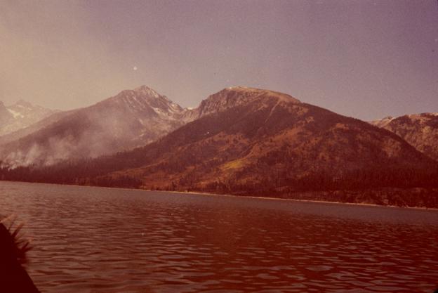
While NPS perceived Waterfalls Canyon as a successful test of let-burn management, decades of suppression had pushed the public to fear fire, generating controversy. By September 18, the blaze burned 1,900 acres, and smoke from it reached the nearby town of Jackson, Wyoming. The Park Service estimated that about 100,000 tourists observed the smoke, and it incensed Jackson’s citizens, many of whom relied on tourist traffic from Grand Teton to make a living. Residents complained that the let-burn policy ignored the needs of local communities, drawing increased attention to the flames. The National Broadcasting Company (NBC), the Columbia Broadcasting System (CBS), and <em>Time </em>magazine reported on Waterfalls Canyon in September, bringing it to national attention. In response to the controversy, the Park Service’s Rocky Mountain regional office issued a press release that explained the let-burn approach.
Despite public backlash, Park Service officials never suppressed Waterfalls Canyon. Snow finally extinguished it in November 1974, and it only burned 3,500 acres. However, the negative publicity pushed NPS to educate the public about the let-burn approach. In 1974, the Park Service issued a press release that argued that natural fires maintained a healthy landscape in parks. Three years later, a Park Service policy known as NPS-18 approved let-burn management nationwide.</p><p><em><strong><a href="https://www.intermountainhistories.org/items/show/914">For more (including 3 images) view the original article</a></strong></em></p>]]></summary>
    <published>2025-09-23T15:39:29+00:00</published>
    <updated>2026-04-17T19:32:21+00:00</updated>
    <link rel="alternate" type="text/html" href="https://www.intermountainhistories.org/items/show/914"/>
    <id>https://www.intermountainhistories.org/items/show/914</id>
    <author>
      <name>Kaylen Wilson, Northern Arizona University </name>
    </author>
  </entry>
  <entry>
    <title type="html"><![CDATA[1967 Fire Season, Glacier National Park]]></title>
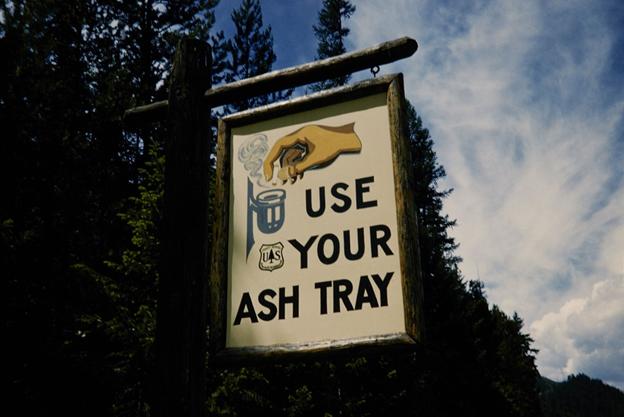
    <summary type="html"><![CDATA[<p><strong><em>Glacier National Park burned more frequently throughout its history than almost any other national park in the United States. Starting in 1910, the National Park Service persistently extinguished all wildfires that occurred within parks, but Glacier’s severe fire season in 1967 helped to end this suppression policy.</em></strong></p><img src="https://www.intermountainhistories.org/files/fullsize/75678ebbab988382ceaac098ab81df69.jpg" alt="Fire Safety Sign" /><br/><p>Throughout the early twentieth century, Glacier National Park in Montana utilized suppression, which required federal land management agencies to extinguish all forest fires. This approach gained national support after millions of acres of land burned in Idaho and Montana in 1910, including about 60,000 acres in Glacier. When 50,000 acres of Glacier burned in 1926, the National Park Service began to formulate official firefighting in the park. By 1929, Chief Forester John D. Coffman drafted the first national park fire management plan to organize firefighters and their equipment at Glacier. During the same year, the Half Moon Fire burned 50,000 acres in Glacier and destroyed numerous buildings. Coffman used analyses of Half Moon to revise and expand his initial strategy, making suppression an integral part of park policy.
In the 1960s, NPS developed a scientific approach to park management that changed the way it approached wildfires, but individual parks rarely aligned their management procedures with these ideas. In 1963, the Advisory Board on Wildlife Management, created by Interior Secretary Stuart Udall, published the Leopold Report. It stated that flames played a key role in maintaining healthy forests, advising administrators to contain wildfires and allow them to burn. Without routine burning, plant materials accumulated on the forest floor, fueling more destructive blazes. However, decades of fighting fires pushed park managers to fear the damage they caused. For decades, NPS managed forests to create attractive landscapes for visitors, and burned forests challenged this idealized image. As such, Glacier’s revised 1965 management plan upheld suppression.
In 1967, a significant drought and hot, windy weather created optimal conditions for flames to spread in Glacier. On August 11, 1967, lightning sparked approximately twenty-one fires throughout the park, including the Glacier Wall and Flathead blazes. They continued burning for a month despite containment efforts. The Office of Emergency Preparedness declared Glacier and the national forests surrounding it a national disaster area, contributing federal funding and labor to put out the flames. 1967 became the most destructive fire season Glacier had seen since 1929, and about 90,000 acres in the park burned.
The 1967 season quickly sparked a debate between the Park Service and the public over suppression. NPS officials contrasted it with the 1910 season  it to display the effectiveness of the policy, noting that less acres burned and less people died in the 1967 fires. However, inholders, who owned cabins, ranches, and hotels in Glacier, blamed the Park Service for mismanaging burns that damaged their properties. One vocal inholder, Montana Senator Burton Wheeler, brought these criticisms to national attention, prompting NPS to reassess its firefighting policies. In 1968, the Park Service acknowledged the ecological benefits of fire in the Green Book, a policy document that established budgets and dictated management policies for the entire park system. Revising this document made changing the suppression policy an issue of national importance. By 1977, Glacier’s management plan allowed natural fires to burn.</p><p><em><strong><a href="https://www.intermountainhistories.org/items/show/913">For more (including 5 images) view the original article</a></strong></em></p>]]></summary>
    <published>2025-09-23T15:39:29+00:00</published>
    <updated>2026-04-17T19:32:21+00:00</updated>
    <link rel="alternate" type="text/html" href="https://www.intermountainhistories.org/items/show/913"/>
    <id>https://www.intermountainhistories.org/items/show/913</id>
    <author>
      <name>Kaylen Wilson, Northern Arizona University </name>
    </author>
  </entry>
  <entry>
    <title type="html"><![CDATA[Rebranding Mount Doane to First Peoples Mountain in Yellowstone]]></title>
    <summary type="html"><![CDATA[<p><strong><em>Mount Doane, a prominent mountain in Yellowstone National Park, was named in honor of Lt. Gustavus Doane, an early explorer of the park. However, his mistreatment of Native people has led the park to collaborate with Native communities to rename the peak First Peoples Mountain. </em></strong></p><img src="https://www.intermountainhistories.org/files/fullsize/890b4c397eef6073bf635775a998d2aa.jpg" alt="Mounts Doane and Stevenson, east of southwest arm of Yellowstone Lake" /><br/><p>Lieutenant Gustavus C. Doane ventured through Yellowstone National Park in the early 1870s on a commission by the United States government to explore the western territory. In 1871, the Hayden Geological Survey named a prominent mountain after the military leader, effectively preserving his legacy. Mount Doane stood as a monument to the lieutenant’s efforts and exploration in the West. But this narrative by the Geological Survey left much untold. </p><p>Doane participated in several conflicts with Native people including the Sioux War, the Nez Perce War, and the Apache Campaign in the years leading up to his exploration of Yellowstone. In 1870, he led an attack against the Piikani/Piegan Blackfeet, now known as the Marias Massacre. On January 23, 1870, the United States Army attacked Chief Heavy Runner’s Piegan village at dawn, killing some 173 people, including elderly and children. The camp had been ravaged by smallpox, leaving them defenseless. Such an atrocity went unacknowledged while Mount Doane stood as a legacy to one of the men who perpetrated it. </p><p>To better represent Indigenous peoples and their histories, Yellowstone National Park sought to change the name of Mount Doane and other controversially named sites. The park reached out to organizations like the Rocky Mountain Tribal Council and the Wyoming Board of Geographic Names. In collaboration with and recommendations by these groups, the National Park Service changed the peak’s name to First Peoples Mountain on June 9, 2022. With a vote of 15-0 in support of the change by the US Board on Geographic Names, the mountain became a monument to the memory of the people killed in the Marias Massacre. This change marks an important shift in the ways Indigenous peoples are represented in the historical narrative and historical memory. </p><p><em><strong><a href="https://www.intermountainhistories.org/items/show/855">For more (including 2 images) view the original article</a></strong></em></p>]]></summary>
    <published>2024-09-25T04:33:01+00:00</published>
    <updated>2026-04-17T19:32:19+00:00</updated>
    <link rel="alternate" type="text/html" href="https://www.intermountainhistories.org/items/show/855"/>
    <id>https://www.intermountainhistories.org/items/show/855</id>
    <author>
      <name>Lauren Barney, Brigham Young University</name>
    </author>
  </entry>
  <entry>
    <title type="html"><![CDATA[Many Glacier Hotel: Glacier National Park ]]></title>
    <summary type="html"><![CDATA[<p><strong><em>After Congress created Glacier National Park in 1910, the Great Northern Railway constructed a complex network of hotels, chalets, roads, trails, and tent camps in the region. The railroad modeled this system after luxury resorts in Europe, and Many Glacier Hotel served as one of its crown jewels.</em></strong></p><img src="https://www.intermountainhistories.org/files/fullsize/2eecb9d891c46a783d81ec6dcc049230.jpg" alt="Many Glacier Hotel, c. 1921" /><br/><p><span style="font-weight:400;">Constructed at the edge of what is now Swiftcurrent Lake, Many Glacier Hotel provided the Great Northern Railway’s second grand hotel at Glacier National Park. It served as the center of the Great Northern’s network of chalets and tent camps alongside the 1910 Glacier Park Hotel. From the grand hotels, tourists could access chalets and tent camps in Glacier’s backcountry. Visitors accessed these locations on horseback, but automobiles later drew tourists away from them. The Great Northern brought an unprecedented level of development into Glacier, and it spent approximately $1.5 million on hotels, chalets, campsites, trails, and roads by 1917. Many Glacier Hotel cost $400,000. </span>
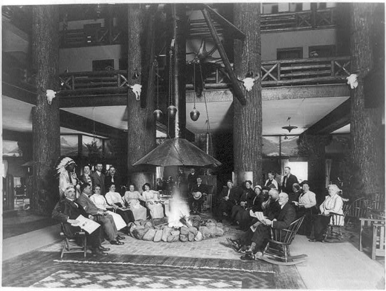
<span style="font-weight:400;">Designed by Great Northern architect Thomas D. McMahon, the hotel comprises three separate buildings connected by covered walkways. The central portion opened in 1915, but the railroad did not complete the hotels’ north and south ends until 1917. Its rough stone siding and foundations resemble the rustic architecture that was becoming increasingly common in national parks. The architect further emphasized this feature in the lobby, which included a grand fireplace and tall wooden support pillars. This imitated the “forest” lobby at Glacier Park Hotel, which uses massive Douglas fir trees as pillars and includes an open fire pit. Many Glacier briefly featured an indoor pool, but the Great Northern removed it due to sanitary issues. </span>
<span style="font-weight:400;">The railroad also intended Many Glacier to match the Great Northern’s other buildings in the park, which imitate Swiss chalets. The hotel’s three sections look like individual Swiss chalets from a distance. Wooden pieces called moldings adorn their windows and balconies, and these pieces feature cutout patterns inspired by the Swiss chalet style. This created a unified sense of place in the region and emulated Glacier’s status as the “Switzerland of North America.” Early advertisements capitalized on this idea during World War I, encouraging guests to “see America first” instead of spending their vacation money to visit foreign locales. The Great Northern hired numerous artists to paint Glacier National Park, and their work hung in train depots and ticket offices. The railroad displayed a variety of paintings from the See America First in Many Glacier Hotel, but only a few remain today. </span>
<span style="font-weight:400;">While Glacier National Park quickly became a popular tourist attraction, the Great Northern’s vast building network became increasingly expensive to maintain. Initially, the railroad kept its resort system to draw train passengers into the park, but it made numerous attempts to sell the hotels as more visitors began to arrive by car. In 1957, the Great Northern hired the Knutson Hotel Company to prepare Glacier’s hotels for sale, and Glacier Park Inc. purchased them in 1960. In 2001, the National Park Service funded a $42 million restoration project that replaced the lodge’s roof and siding, restored original architectural features like balconies, and reinstalled an original circular staircase that the Knutson Hotel Company removed from the hotel lobby in 1957. Xanterra Parks and Resorts currently manages Many Glacier Hotel.</span></p><p><em><strong><a href="https://www.intermountainhistories.org/items/show/842">For more (including 5 images) view the original article</a></strong></em></p>]]></summary>
    <published>2024-05-29T21:10:56+00:00</published>
    <updated>2026-04-17T19:32:19+00:00</updated>
    <link rel="alternate" type="text/html" href="https://www.intermountainhistories.org/items/show/842"/>
    <id>https://www.intermountainhistories.org/items/show/842</id>
    <author>
      <name>Kaylen Wilson, Northern Arizona University</name>
    </author>
  </entry>
  <entry>
    <title type="html"><![CDATA[Glacier Park Hotel - Glacier National Park]]></title>
    <summary type="html"><![CDATA[<p><strong><em>In 1911, the Great Northern Railway began constructing a complex network of hotels and chalets in the fledgling Glacier National Park. Originally nicknamed the “Entrance hotel,” Glacier Park Hotel provided a gateway to this unique resort system.</em></strong></p><img src="https://www.intermountainhistories.org/files/fullsize/06a86c061b2ec07ad3f9f6d5b187daae.jpg" alt="Glacier Park Hotel lobby, c. 1910-20" /><br/><p><span style="font-weight:400;">The Great Northern Railway constructed Glacier Park Hotel in 1913 to provide visitors touring Glacier National Park with a starting point along the railroad. From Glacier Park Hotel, these tourists entered a complex system of smaller chalets and tent camps. Each hotel and chalet included a guide operation that provided saddle horses to visitors, who entered the area from a train depot connected to the Glacier Park complex. Resorts in Europe inspired this system, and an American national park had never utilized it. The resort brought an unprecedented level of development into Glacier, and the Great Northern spent about $1.5 million dollars (about $36 million today) on hotels, chalets, campsites, trails, and roads by 1917. </span>
<span style="font-weight:400;">The Great Northern Railroad executive F.I. Whitney encouraged the railroad to seek out tourist attractions in the Glacier region as soon as it reached the park’s southern end. Famous conservationists like George Bird Grinnell and John Muir, who brought Glacier to the attention of railroad founder James J. Hill and his son Louis, reinvigorated Whitney’s efforts. The failure of local oil and copper and oil industries provided a political opening for conservationists, and James J. Hill soon began to advocate for the area’s protection. However, Hill opposed the conservationists’ idea of a vast forest reserve at Glacier, and this ultimately shaped the park’s development. President William Howard Taft signed the bill that protected Glacier National Park in 1910. </span>
<span style="font-weight:400;">Luxurious chalets in Switzerland inspired the architecture of Glacier Park Hotel and the Great Northern’s other buildings, which catered to the tastes of wealthy travelers. Louis Hill, who served as president of the Great Northern during construction, chose this style. It connected the system visually and advertised Glacier’s reputation as the “Switzerland of North America.” Glacier Park Hotel, designed by Samuel Bartlett, is particularly famous for its massive log pillars, which support the hotel’s vast roof. These logs vary in size, with the largest being over forty feet tall and three to four feet wide, and they are most prevalent in the hotel’s lobby. Advertised as a “forest,” these log posts retain their bark, emphasizing their organic nature and contributing to the idea of an indoor forest. The lobby even includes a fire pit in its center. These features emphasized the hotel’s environment and emulated the rough, handcrafted style popularly defined as rustic architecture. The luxurious complex included a</span> <span style="font-weight:400;">music room, writing room, a sun parlor, and a hospital in case of emergencies. </span>
<span style="font-weight:400;">In 1957, the Great Northern hired Knutson Hotel Company to renovate its hotels for sale. The $3 million project expanded the hotel gift shop, installed bathrooms in all the guest rooms, added a swimming pool to the hotel complex, and renamed the hotel Glacier Park Lodge. In 1960, Glacier Park Inc. purchased the Glacier resort system from the Great Northern. The National Park Service granted Xanterra Parks and Resorts concession rights in Glacier in 2013, but Glacier Park Inc. retained Glacier Park Lodge and several other properties.</span></p><p><em><strong><a href="https://www.intermountainhistories.org/items/show/841">For more (including 4 images) view the original article</a></strong></em></p>]]></summary>
    <published>2024-05-29T20:53:22+00:00</published>
    <updated>2026-04-17T19:32:19+00:00</updated>
    <link rel="alternate" type="text/html" href="https://www.intermountainhistories.org/items/show/841"/>
    <id>https://www.intermountainhistories.org/items/show/841</id>
    <author>
      <name>Kaylen Wilson, Northern Arizona University</name>
    </author>
  </entry>
  <entry>
    <title type="html"><![CDATA[El Tovar Hotel - Grand Canyon National Park ]]></title>
    <summary type="html"><![CDATA[<p><strong><em>In 1901, the Atchison-Topeka Santa Fe Railway constructed a spur line from Williams, Arizona, that provided access to the Grand Canyon’s South Rim. El Tovar soon followed, providing its guests with the region’s first luxury accommodations.</em></strong></p><img src="https://www.intermountainhistories.org/files/fullsize/4856f91fdf081f933e9854aa688f9055.jpg" alt="El Tovar’s east side, circa 1905" /><br/><p><span style="font-weight:400;">Before the Atchison-Topeka Santa Fe Railway reached Grand Canyon Village in 1901, only a few rudimentary hotels served the Grand Canyon’s South Rim. These establishments relied on a local stagecoach line, which operated between Flagstaff, Arizona and a ranch near the rim. Because the twenty-dollar journey took three days to complete, the railroad provided a more efficient way to reach the canyon, and its arrival shifted the center of activity at Grand Canyon Village away from Thurston’s stagecoach line. Fred Harvey, a hospitality company whose Harvey houses provided quality food and lodging to passengers on the Santa Fe Railway, constructed El Tovar near the railroad tracks to draw in train passengers. The hotel cost $250,000 to construct, providing the Grand Canyon’s first luxury lodgings. </span>
<span style="font-weight:400;">Opened in 1905, El Tovar hotel predated the Grand Canyon’s designation as a national monument in 1908 and a national park in 1919. As a national monument, the Grand Canyon received less funding and attention than established national parks like Yellowstone. However, as tourism increased, calls for the area to receive further protections intensified. Ford Harvey, who served as president of the Harvey company until 1928, routinely advocated for Grand Canyon’s national park status at conferences. Conservation efforts gained strength when Arizona became a state in 1912, but many Grand Canyon residents opposed the national park proposal due to concerns about land and mineral rights. Regardless, President Woodrow Wilson officially signed the bill that established Grand Canyon National Park on February 26, 1919, and the Harvey company secured a hospitality contract from the new National Park Service (created in 1916) in 1920.</span>
<span style="font-weight:400;">Architect Charles Whittlesey’s design for El Tovar used the rustic architectural style, which aimed to establish a connection between buildings and their environment. Whittlesey designed the log siding on the first floor to resemble the wall of a log cabin. Natural building materials like rough stone and logs appear throughout the building, reinforcing this style. Whittlesey combined these rustic features with the architecture of traditional luxury resorts, which catered to Victorian tastes and a desire for exotic destinations. Decorative wooden poles known as balusters, which mimic Swiss chalet architecture, enclose El Tovar’s porches and balconies. The design also includes a small round tower known as a turret, which echoes resort architecture. </span>
<span style="font-weight:400;">El Tovar originally featured luxurious amenities, including hot running water and electric lighting. In the 1950s, the Harvey company added a new cocktail lounge to the hotel’s dining area. A 1983 renovation exchanged the hotel’s sparse public restrooms with private facilities, added carpeting, replaced windows, and included a new heating system. For this reason, El Tovar currently houses seventy-nine rooms instead of the original ninety-five. In 1968, Hawaii-based hospitality company Amfac purchased the Harvey company and gained control of El Tovar. In the 1990s, Amfac created Xanterra Parks and Resorts to control its concessions at the Grand Canyon, and Xanterra still manages El Tovar today. </span></p><p><em><strong><a href="https://www.intermountainhistories.org/items/show/840">For more (including 6 images) view the original article</a></strong></em></p>]]></summary>
    <published>2024-05-29T20:25:01+00:00</published>
    <updated>2026-04-17T19:32:19+00:00</updated>
    <link rel="alternate" type="text/html" href="https://www.intermountainhistories.org/items/show/840"/>
    <id>https://www.intermountainhistories.org/items/show/840</id>
    <author>
      <name>Kaylen Wilson, Northern Arizona University </name>
    </author>
  </entry>
  <entry>
    <title type="html"><![CDATA[Old Faithful Inn - Yellowstone National Park]]></title>
    <summary type="html"><![CDATA[<p><strong><em><span style="font-weight:400;">When the Northern Pacific Railroad’s Upper Geyser Basin Hotel burned to the ground on November 17, 1894, the U.S government pressured the railroad to replace it with new tourist accommodations. The result was Old Faithful Inn, which utilized a new style of architecture to highlight Yellowstone’s iconic landscape. </span></em></strong></p><img src="https://www.intermountainhistories.org/files/fullsize/eddddd6f4d185123b8615299ae39a69b.jpg" alt="Old Faithful Inn, Entrance Drive" /><br/><p><span style="font-weight:400;">On March 1, 1872, President Ulysses S. Grant officially signed Yellowstone into law as America’s first national park. The Yosemite Act of 1864 had restricted settlement in the Yosemite Valley and placed it under the jurisdiction of California’s state government, but the Yellowstone Park Act expanded upon this legislation by designating all of Yellowstone a public park. As a result, the Yellowstone Park Act contained many restrictions on private development and very few administrative procedures to enforce regulations or oversee public use. Poorly supervised independent companies called concessionaires, who paid park administrators a fee to use the land, ran Yellowstone’s public facilities. Only a few concessionaires ferried guests into the park, but the Northern Pacific Railroad quickly expressed interest in Yellowstone’s small tourism industry.</span>
<span style="font-weight:400;">When the Northern Pacific reached Gardiner, Montana, in the early 1880s, its presence provoked interest in Yellowstone’s tourism industry. At this time, only a few concessionaires opened small hotels and tent camps. One such concessionaire, the Yellowstone Park Improvement Company, constructed the Upper Geyser Basin Hotel in 1885 to preserve its failing business. The Northern Pacific purchased its properties in 1885, gaining control of the Upper Geyser Basin Hotel. When fire destroyed it</span><span style="font-weight:400;"> in 1894,</span><span style="font-weight:400;"> the importance of a new hotel in Yellowstone became clear</span><span style="font-weight:400;">. At the time</span><span style="font-weight:400;">, many railroad hotels utilized conventional architectural styles that provided a sense of familiarity for their upper-class audience. The Northern Pacific’s Lake Hotel, constructed in 1890, followed this example. However, </span><span style="font-weight:400;">rustic architecture, which emphasized harmony with the natural environment surrounding a structure, gained popularity in the 1890s. Because distinctive architecture drew more attention from visitors, the Northern Pacific experimented with a rustic style for its new hotel. </span>
<span style="font-weight:400;">The Yellowstone Park Association, a subsidiary of the Northern Pacific, selected Robert Reamer to design its new rustic hotel. The railroad constructed the log building near Yellowstone’s most famous geyser, from which the Old Faithful Inn derived its name. </span><span style="font-weight:400;">The Union Pacific completed the central core of the hotel, known as the “Old House,” in 1903.</span><span style="font-weight:400;"> The finished building was seven stories tall at its highest point, and it cost a total of $140,000 (about $4.9 million today) to construct. The Northern Pacific set aside a further $25,000 (approximately $875,000 today) to furnish the new hotel. Reamer designed his massive log structure to emulate Swiss chalets and Norwegian villas, and he utilized rough, unfinished wood logs obtained in the Park on both the inside and outside of the building to connect it to Yellowstone’s forested landscape. The hotel’s most prominent feature is its seven-story lobby, which features a vast fireplace made of native stone. A complex log frame that supports the hotel’s roof surrounds this room. The structure’s use of exposed wooden supports emphasizes the rustic nature of the lobby, and a series of wooden balconies overlook the main floor of the hotel. </span></p><p><em><strong><a href="https://www.intermountainhistories.org/items/show/839">For more (including 5 images) view the original article</a></strong></em></p>]]></summary>
    <published>2024-05-29T19:43:03+00:00</published>
    <updated>2026-04-17T19:32:19+00:00</updated>
    <link rel="alternate" type="text/html" href="https://www.intermountainhistories.org/items/show/839"/>
    <id>https://www.intermountainhistories.org/items/show/839</id>
    <author>
      <name>Kaylen Wilson, Northern Arizona University</name>
    </author>
  </entry>
  <entry>
    <title type="html"><![CDATA[Holbrook Hauntings]]></title>
    <summary type="html"><![CDATA[<p><strong><em><span style="font-weight:400;">Once a dangerous and gritty “Wild West” town, Holbrook has survived against all odds and exists as a remnant of old roadside Americana.</span></em></strong></p><img src="https://www.intermountainhistories.org/files/fullsize/a24896a4baf9a1bbccb5cc8faa456ec3.jpg" alt="Wigwam Motel in Holbrook, Arizona" /><br/><p><span style="font-weight:400;">Located in the Painted Desert badlands of Arizona, Holbrook is one of the most famous towns along Route 66. While the town holds fast to its historic roots, it is still very much alive with a population of 4,854 in 2022. One of the biggest draws to Holbrook is its position as the gateway to the Petrified Forest National Park. Another popular attraction is the Wigwam Motel, sometimes referred to as “The Wigwam Village,” which opened in 1950. The motel consists of fifteen concrete dwellings, designed in the style of traditional Native American huts. Old diners, “Wild West” style saloons, and a historical society museum also point visitors to the storied past. The town was named after Henry Holbrook, who, as the chief engineer for the Atlantic Pacific Railroad, played a crucial role in Westward Expansion.</span>
<span style="font-weight:400;">Holbrook once described the town as, “too tough for women and churches.” In the early years, around its founding in 1888, there was little order or consequence to breaking the law. Outlaws from Texas and other surrounding territories often started new lives in Holbrook and surrounding towns, finding freedom from past charges and wreaking havoc on less developed and surveyed communities. Violent crime was common in Holbrook, especially gun-fights and theft, as people decided to take justice into their own hands. One of the most famous feuds in the region, the Pleasant Valley War, involved the Hashknife Cowboys of Holbrook–a group of men who worked for the Aztec Land and Cattle Company. In response to all of the disorder, the Navajo County Courthouse–which included a basement prison–was built in 1899. Some people claim that the old prison cells and Sheriff’s office in the basement are haunted, which is not the first claim of a supernatural element to the area. </span>
<span style="font-weight:400;">As the only national park encompassing a part of Route 66, the Petrified Forest has its fair share of lore. The land has long attracted visitors, curious about and entranced by the abundance of petrified wood. This natural phenomena occurs when minerals, like quartz,  invade the cavities in a piece of wood–the reaction giving the wood a colorful marble-like appearance. In the mid-1800s travelers would pile as many pieces of petrified wood as would fit in their wagons and automobiles. It became common practice for anyone who passed through to take home a piece of petrified wood. The Petrified Forest was declared a national monument in 1906 and then a national park in 1962, both of which made it illegal to take anything from the land. Still, many disregarded the law and continued to steal chunks of petrified wood. Several accounts of freak accidents and misfortune falling upon the thieves fueled the legend that the forest was cursed. The park began to receive packages and letters of confession, apologizing and begging park rangers to return what they had stolen in an attempt to “undo the curse.” </span>
<span style="font-weight:400;">One of the last Route 66 towns to get bypassed by Interstate 40, the community of Holbrook is nothing if not resilient. There were a decent amount of stubborn business owners and residents who stayed despite the rapid decline in population and tourism. Nothing if not resilient, Holbrook survived the gas shortage of the World War II years and rose from the ashes once again after Route 66 was stripped of its status as the great American highway. Holbrook carries on as a popular stop for its old school charm and novelty. </span></p><p><em><strong><a href="https://www.intermountainhistories.org/items/show/807">For more (including 5 images) view the original article</a></strong></em></p>]]></summary>
    <published>2024-05-16T02:20:42+00:00</published>
    <updated>2026-04-17T19:32:18+00:00</updated>
    <link rel="alternate" type="text/html" href="https://www.intermountainhistories.org/items/show/807"/>
    <id>https://www.intermountainhistories.org/items/show/807</id>
    <author>
      <name>Megan Bailey, Brigham Young University</name>
    </author>
  </entry>
  <entry>
    <title type="html"><![CDATA[Indigenous People of Bryce Canyon]]></title>
    <summary type="html"><![CDATA[<p><strong><em><span style="font-weight:400;">The place known today by millions of people as Bryce Canyon National Park has been known by different names to many other people over centuries. The history of those who have journeyed along the canyon before paths were paved there still have a deep connection to the land. And over the past century, an increasing number of people admire the beauty and appreciate such a connection.</span></em></strong></p><img src="https://www.intermountainhistories.org/files/fullsize/83f8b3ce41456cf4cf8fa80c55f1fc6d.jpg" alt="[Untitled]" /><br/><p><span style="font-weight:400;">Unka tumpee wun-nurrx tungwatsini xoopakichu ahnax, Sikyaatutukwi, Bios to chi bi kool, Angka-ku-wass-a-wits, Bryce’s Canyon. </p><p>These are the former names of the geographic marvel now known as Bryce Canyon National Park. Southern Paiutes, Hopi, Zuni, Ute, and Navajo tribes all lived in this region and enjoyed its natural beauty and wonders. Even before these nations, other ancient peoples lived here for centuries. The Indian names, meaning “place of yellow points,” “red painted faces,” and “red rock standing like a man in a hole,” come from ancient legends of the rock formations now called “hoodoos,” meaning scary or a bad omen. Some claimed that the hoodoos were once people who had been turned to stone. This incredible landscape provided a place for indigenous peoples to hunt and gather grass seeds and other foods, creating a deep connection with the land. </span>
<span style="font-weight:400;">Sadly, from 1850 to 1890, through various laws, acts, and atrocities, Native Americans were forced from Bryce Canyon, some to distant reservations. Those that were far removed from Bryce Canyon, like the Navajo, remembered its beauty through oral histories. The Paiutes were not driven out until about 1880, five years after LDS Scottish Rancher Ebenezer Bryce settled there. From the turn of the century onward, new people began coming into the area to settle or sight-see. In 1916, with help from the Union Pacific Railroad, lodges and rest stations began to be built, providing a place for visitors to stay. In 1923, Bryce Canyon became a National Monument and in 1928 it became a National Park, with the boundaries expanded in 1931 and again in 1942. In 1934 workers of the Civilian Conservation Corps created much of the infrastructure that helped make Bryce Canyon more accessible to the public. Today this beautiful National Park is visited by over 1.5 million people annually.</span>
<span style="font-weight:400;">Though this park is now accessible to many people, the indigenous nations that once lived there still have a great connection to the land through their histories and traditions. In past decades most members of those nations lack the resources needed to visit Bryce Canyon, though more indigenous people are able to visit these sacred sites today. They continue to pass on the traditions and stories to new generations. Some Paiutes have returned to the area and still live nearby. Dozens of people currently reside within Bryce Canyon's lands. Leigh Kuwanwisiwma, a member of the Hopi Tribe, teaches “This is our heaven. This is the human people’s heaven, and we need to appreciate that.” A sacred place to many tribes, and now a nationally protected park, Bryce Canyon deserves respect and reverence as visitors admire its wonders.</span></p><p><em><strong><a href="https://www.intermountainhistories.org/items/show/787">For more (including 3 images) view the original article</a></strong></em></p>]]></summary>
    <published>2024-03-01T23:35:49+00:00</published>
    <updated>2026-04-17T19:32:17+00:00</updated>
    <link rel="alternate" type="text/html" href="https://www.intermountainhistories.org/items/show/787"/>
    <id>https://www.intermountainhistories.org/items/show/787</id>
    <author>
      <name>Rachel Feilbach, Brigham Young University</name>
    </author>
  </entry>
  <entry>
    <title type="html"><![CDATA[Origins of Bryce Canyon National Park]]></title>
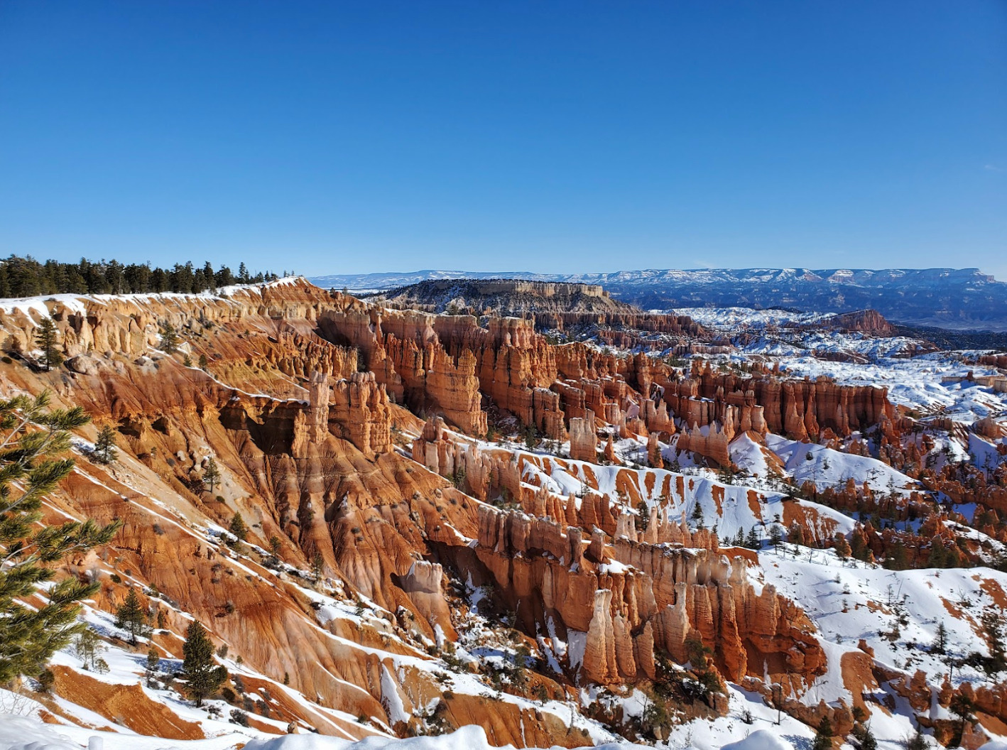
    <summary type="html"><![CDATA[<p><strong><em><span style="font-weight:400;">The land around Bryce Canyon was owned by Paiutes, Mormon settlers, the Union Pacific Railroad, and the federal government before it became a national park in 1924. This gorgeous geological wonder is now enjoyed by millions of visitors each year.</span></em></strong></p><img src="https://www.intermountainhistories.org/files/fullsize/4583d33941339bd9472eeb68144da8cd.jpg" alt="Snow on the Rim of Bryce Canyon" /><br/><p><span style="font-weight:400;">According to archaeological surveys, Bryce Canyon has been inhabited for at least 10,000 years. Paiutes hunted small game and gathered pine nuts in the area. After the Black Hawk War in the 1860s, Mormon settlers moved into areas previously occupied by the Paiutes. One such settler was Ebenezer Bryce, who built a road through the canyon that adopted his name. Mormons in the small settlement of Tropic built the Tropic Irrigation Ditch through Bryce Canyon in 1892. For decades, the beautiful scenery of Bryce Canyon was largely kept private due to the difficulty of travel and the harsh conditions of the area.</span>
<span style="font-weight:400;"> S. Forest Service Supervisor J.W. Humphrey pushed for Bryce Canyon to become a National Park after he first visited the land in 1915. He said, “You can perhaps imagine my surprise at the indescribable beauty that greeted us, and it was sundown before I could be dragged from the canyon view. You may be sure that I went back the next morning to see the canyon once more, and to plan in my mind how this attraction could be made accessible to the public.” After sending photographs and film to the federal Forest Service and the Union Pacific Railroad, the canyon began to attract national attention. Ruby and Minnie Syrett bought land along the rim of Bryce Canyon and built a lodge and an inn for tourists in the 1920s. The Union Pacific Railroad bought much of the land from the Syretts, but Ruby’s Inn still stands today.</span></p><p><span style="font-weight:400;">Bryce Canyon was declared a national monument in 1923 by President Warren G. Harding. On February 25, 1928, Bryce Canyon officially became a national park by an act of  Congress. The size of the park was increased in 1931 by President Hoover, to the current 35,835 acres. Today, over 2 million people visit the park each year to enjoy southern Utah’s stunning scenery and recreational opportunities.</span></p><p><em><strong><a href="https://www.intermountainhistories.org/items/show/784">For more (including 4 images) view the original article</a></strong></em></p>]]></summary>
    <published>2024-02-26T20:05:24+00:00</published>
    <updated>2026-04-17T19:32:17+00:00</updated>
    <link rel="alternate" type="text/html" href="https://www.intermountainhistories.org/items/show/784"/>
    <id>https://www.intermountainhistories.org/items/show/784</id>
    <author>
      <name>Renae Cameron, Brigham Young University</name>
    </author>
  </entry>
  <entry>
    <title type="html"><![CDATA[North Rim Lookout Tower]]></title>
    <summary type="html"><![CDATA[<p><strong><em>The North Rim Lookout Tower helped to protect the area of the Grand Canyon. One can still appreciate immaculate views of the Grand Canyon from high above northern Arizona’s ponderosa forests at the North Rim Lookout Tower which is available to hikers. </em></strong></p><img src="https://www.intermountainhistories.org/files/fullsize/163624658f254fa48626545cb65fa694.jpg" alt="Fire Lookout in the Grand Canyon" /><br/><p><p style="font-weight:400;">Following the Great Fire of 1910, which devastated much of the northern Rocky Mountains, the Forest Service prioritized wildfire suppression. By the mid-1910s, it constructed three small platforms along the Canyon’s edge to spot fires. The North Rim platform, constructed at Bright Angel Point, provided forest rangers and tourists with impeccable views of the forests which lined the Canyon.</p><p>As one of the natural wonders of the world, the Grand Canyon is widely considered one of America’s environmental gems. Federal attempts to preserve the Canyon date all the way back to the late nineteenth century, when the then Indiana Senator, Benjamin Harrison, proposed three bills in the 1880s to set aside the canyon as a national park.<span> </span>Though each of the bills failed, President Harrison eventually granted the Grand Canyon status as a Forest Reserve in the waning days of his presidency in 1893. After President Theodore Roosevelt visited the area in 1903, he granted the site status as a National Monument in 1908, <span>replacing Harrison’s reserve</span><span> </span>. The National Park Service wouldn’t be founded for another eight years, so the Monument fell under control of the fledgling US Forest Service.
<p style="font-weight:400;">The Grand Canyon gained status as a National Park in 1919. The Park Service continued the Forest Service’s policy of fire suppression, and in 1928, it replaced the platform with a seventy five-foot tall steel tower. Topped with a tiny observation cab, fire lookouts lived in a small cabin beneath the structure. Under contract, the Aeromotor Company constructed the Bright Angel Lookout Tower. Aerometer also designed and produced the iconic windmill water pumps which became a symbol of the American West during the late nineteenth and early twentieth centuries.
<p style="font-weight:400;">During the 1930s, the Civilian Conservation Corps (CCC) updated much of the North Rim’s infrastructure. This included moving the Bright Angel Lookout roughly fourteen miles away to the Park’s northern entrance. In 1933, the CCC renamed the structure the North Rim Lookout Tower.
<p style="font-weight:400;">From the late 1960s to the early 1970s, writer and environmentalist Edward Abbey spent four seasons working in the tower. Abbey’s time in the station inspired his book <em>Black Sun, </em>a novel which tells the story of a fire lookout in the Grand Canyon who falls in love with a tourist. When she goes missing, the lookout is blamed for her mysterious disappearance. In his book <em>Fire on the Rim</em>, Stephen Pyne references Abbey as the reason the Park ceased lookout tower operations. “Whether [Abbey] was even in the tower, no one could say. He was a writer, and the only smokes he reported were the ones in his novels… he was absent so often that he demonstrated that we did not need a lookout, because having [Abbey] in the tower was the same as having no one.” Ultimately, the Park opted for aerial fire spotting instead.
<p style="font-weight:400;">Though abandoned, North Rim Lookout Tower is still accessible. Hikers can reach the site via a short hike from the Park’s northern entrance toll booth.</p><p><em><strong><a href="https://www.intermountainhistories.org/items/show/709">For more (including 5 images) view the original article</a></strong></em></p>]]></summary>
    <published>2023-02-23T00:36:16+00:00</published>
    <updated>2026-04-17T19:32:15+00:00</updated>
    <link rel="alternate" type="text/html" href="https://www.intermountainhistories.org/items/show/709"/>
    <id>https://www.intermountainhistories.org/items/show/709</id>
    <author>
      <name>Tanner Hammarstrom, Northern Arizona University</name>
    </author>
  </entry>
  <entry>
    <title type="html"><![CDATA[The Creation of Canyonlands National Park<br />
]]></title>
    <summary type="html"><![CDATA[<p><strong><em>Although the area of Canyonlands National Park enthralled many visitors for years before the creation of a national park there, the road to becoming federally protected land took many years, controversies, and compromises. </em></strong></p><img src="https://www.intermountainhistories.org/files/fullsize/8560da34733564e52bd87816ca22e0b7.jpg" alt="View of Shafer Trail " /><br/><p>Situated about 40 minutes from Moab, Utah, Canyonlands National Park is the largest and most remote of all the National Parks in the state. Covering 337,589 acres, the park is split into three major districts by the Colorado and Green rivers known as the Islands in the Sky, The Needles, and The Maze. The Park is also famous for being the location where the two rivers meet, and home to many ruins and artifacts from ancient peoples who lived there thousands of years ago. Despite the area of the park being famous for its natural wonders, the creation of the park was a long and arduous process that included many controversies and compromises. </p><p>Serious consideration for creating the area into a National Park grew in the early 1960s after the election of President John F. Kennedy and his appointment of Stewart Udall as Secretary of the Interior. Udall believed heavily in conservation and was enthralled by the beauty of the area when he visited in 1961. Recruiting Utah Senator Frank Moss as an ally for the project, the two set out to preserve the Canyonlands area as a National Park. Immediately, Udall and Moss ran into opposition from other local legislators including Utah Senator Wallace Bennett. While Bennett was not completely opposed to the idea of a National Park in the Canyonlands region, he wanted a much smaller protected area in order to keep most of the region open for commercial use. Bennett thought that much of the area was better suited for mining, drilling, and grazing. </p><p>Senators Moss and Bennett fought for a few years before a final proposal was sent to the United States Congress in 1964. This proposal included most of the area that Moss and Udall wanted to have protected, but removed a portion from the north side of the park for commercial developments at the wish of Bennett and other local people. Moss continued to fight to protect more of the land around Canyonlands for the rest of his tenure as senator in Utah and is a large reason that the park is enjoyed by thousands today.</p><p><em><strong><a href="https://www.intermountainhistories.org/items/show/647">For more (including 4 images) view the original article</a></strong></em></p>]]></summary>
    <published>2022-09-12T21:18:55+00:00</published>
    <updated>2026-04-17T19:32:14+00:00</updated>
    <link rel="alternate" type="text/html" href="https://www.intermountainhistories.org/items/show/647"/>
    <id>https://www.intermountainhistories.org/items/show/647</id>
    <author>
      <name>Allie Castañeda and Forrest Filetti, Brigham Young University </name>
    </author>
  </entry>
  <entry>
    <title type="html"><![CDATA[Fruita Schoolhouse: Learning and Community]]></title>
    <summary type="html"><![CDATA[<p><strong><em>Capitol Reef National Park is one of the greatest hidden gems of Central Utah, home to fossils, beautiful hikes, and several historical sites. Of these historical sites, one of the most popular is the Fruita Schoolhouse, a physical memory of what life was like in humble, nineteenth-century Fruita.</em></strong></p><img src="https://www.intermountainhistories.org/files/fullsize/fdf1c72a53ae4ee8430fc91744c589cd.jpg" alt="Step into the past" /><br/><p>In 1893, historian Frederick Jackson Turner famously claimed the year 1890, three years prior, marked the closing of the American Frontier. It seemed in the 1890s that America’s expansionist spirit was shifting from the continental Wild West to locations abroad such as Cuba and the Philippines, pivoting away from consolidating a land empire and toward questing for a sea empire. Pioneers in Fruita, Utah, however, were still preoccupied in the 1890s with frontier processes. Although they had secured their isolated, red rock land, even in 1890 their community lacked important infrastructure such as education, a postal service, and a building for worship.
As they settled in and secured the land, the pioneers were able to gather sufficient time and organization to put together more of a society, beginning with an education system. Nettie Behunin, a young girl 12 years of age, became one of the first teachers.  Nettie might not have been a truly qualified teacher by twenty-first-century standards—or perhaps even by her own—but her endeavors marked the beginning of the first community project in the area: the schoolhouse.
In a collection of childhood memories of Fruita, Clay M. Robinson reflects on his experience as a young boy in the newly built Fruita schoolhouse as his mother was the teacher at the school during his childhood. He writes, “Most vivid of all in those memories, are Mama and the little one-room sawed-log Fruita school where she taught all eight grades in the years 1925–1927.” He also mentioned that the schoolhouse was used for Sunday church services and Sunday School—most of Fruita were members of The Church of Jesus Christ of Latter-day Saints, or Mormons—because there was no dedicated chapel in Fruita. Since residents could rearrange the in the schoolhouse, the small building served as a community center that could host different events like dances, box socials, knitting group meetings, and gatherings for men and young boys who enjoyed baseball. The Fruita schoolhouse evidently served as a center of the community, where the small number of settlers could gather to enjoy each other’s company.
The Fruita schoolhouse still stands today. Tourists can easily see it as they drive through the park since it is located just to the side of the highway. At times the Park Service offers tours in the old schoolhouse that allow small children to briefly roleplay pioneer school life. This schoolhouse represents the first community building of the Fruita settlement, as well as a reminder of what life was like for the small community of Latter-day Saint settlers.</p><p><em><strong><a href="https://www.intermountainhistories.org/items/show/632">For more (including 4 images) view the original article</a></strong></em></p>]]></summary>
    <published>2022-07-01T01:26:07+00:00</published>
    <updated>2026-04-17T19:32:13+00:00</updated>
    <link rel="alternate" type="text/html" href="https://www.intermountainhistories.org/items/show/632"/>
    <id>https://www.intermountainhistories.org/items/show/632</id>
    <author>
      <name>Rachelle E. Robins, Brigham Young University</name>
    </author>
  </entry>
  <entry>
    <title type="html"><![CDATA[Grand Canyon Depot]]></title>
    <summary type="html"><![CDATA[<p><strong><em>Take the Grand Canyon Railway to the historic train depot in Grand Canyon National Park and experience the unique architectural design of the only operating log depot in the United States.</em></strong></p><img src="https://www.intermountainhistories.org/files/fullsize/f9bfc58de0278251fc6045574c950f38.jpg" alt="The depot in 1975" /><br/><p>Designed by architect and Santa Barbara, California native Francis W. Wilson, the Grand Canyon Train Depot is one of fourteen log depots ever constructed in the United States and is now one of only three remaining. Out of these, the Grand Canyon Depot is the only one built mainly from logs and the only one still operating today. The building features a central two-story section and a wing on each side one-story in height. The unique design of the wood—three flat sides and one rounded—allowed the building to give off a frontier appearance while keeping out moisture and maintaining structural integrity. The original copper lettering on the front spelled out “Grand Canon,” but workers replaced it in 1911 to spell “Grand Canyon.” Between the late-1920s and mid-1950s the depot underwent structural and functional renovations which added office space and upgraded lighting.
Before 1901, a trip to the Grand Canyon required a bumpy, sixty-five-mile stagecoach ride on dirt roads to reach the South Rim. To rectify this—and simultaneously capitalize on interest to the park—in 1901, the Santa Fe Railway built a line of tracks connecting their depot in Williams, Arizona to what would become Grand Canyon Village. Instead of going by stagecoach, visitors to the Grand Canyon could ride the train and relax while enjoying the view on the way to one of the greatest natural wonders in the world.
The arrival of the railroad in 1901 shifted the tourist experience to what became the Grand Canyon Village. In 1905, the Santa Fe Railroad completed the El Tovar Hotel between the track and the canyon. Santa Fe then partnered with the Fred Harvey Company and the National Park Service to add more buildings to accommodate the growing number of tourists, including Hopi House, Bright Angel Lodge, and the Red Horse Cabin. Architect Mary Jane Colter designed many of these structures.
Popularity for the railroad dwindled as the automobile industry grew, however; in 1968, the Grand Canyon Railway made its final passenger run, and the Santa Fe Railway left the buildings it owned to the National Park Service. Freight transportation continued on the line, but soon after, in 1972, the railway discontinued passenger services to the Grand Canyon. In 1989 the formation of the Grand Canyon Railway revived the route when entrepreneurs Max and Thelma Biegert funded the restoration of the Grand Canyon Line: tourists once again could travel to the park by train. For visitors today, the station represents the idea of western national parks as rustic and scenic. Often the first experience guests have when they step off the train, the depot remains one of the best structures from the National Park’s rustic period.</p><p><em><strong><a href="https://www.intermountainhistories.org/items/show/603">For more (including 4 images) view the original article</a></strong></em></p>]]></summary>
    <published>2022-06-09T22:59:59+00:00</published>
    <updated>2026-04-17T19:32:13+00:00</updated>
    <link rel="alternate" type="text/html" href="https://www.intermountainhistories.org/items/show/603"/>
    <id>https://www.intermountainhistories.org/items/show/603</id>
    <author>
      <name>Jennifer John, Northern Arizona University</name>
    </author>
  </entry>
  <entry>
    <title type="html"><![CDATA[Zion Lodge]]></title>
    <summary type="html"><![CDATA[<p><strong><em>There are sixty-one registered historic structures in Zion National Park, the buildings of the Zion Lodge complex being among them.</em></strong></p><img src="https://www.intermountainhistories.org/files/fullsize/b99f86cd2dbd3a60e1905a3de5eb0e89.jpg" alt="Probable dedication of Zion Lodge" /><br/><p>The Union Pacific Railroad and its subsidiary, the Utah Parks Company, completed a railway line near Cedar City in 1923, granting visitors of Zion National Park an easy and convenient method of travel from the railway station to the park by motorbus. The Union Pacific also collaborated with the Park Service to build hotels along its routes to attract customers for each company, resulting in the construction of Zion Lodge, an in-park hotel where guests could stay during their travels. Stephen Mather, director of the National Park Service, initially balked at Union Pacific’s desired size for the lodge and requested something smaller. In the end, each side compromised to build a medium-sized lodge that blended into its natural surroundings inside the heart of the canyon. 
Gilbert Stanley Underwood, an American architect who studied at Yale and Harvard, worked with the Utah Parks Company to design the structure, and construction began in 1923. Underwood envisioned the lodge as a warm and inviting atmosphere for guests. The building incorporated 265,000 board feet of lumber from the Colorado Plateau brought down by the Cable Mountain Draw Works, a mechanism of wires and pulleys extending from the top of the canyon to an area 2,000 feet below. Construction teams finished the lodge in May 1925, and the park held a small dedication ceremony on the front lawn. The later addition of individual cabins to the lodging accommodations in Zion signaled a milestone in park success and development.
The original lodge featured natural wood design, locally sourced stone for the entrance columns, and a green roof that harmonized the building with its surrounding canyon and forest environment. The original structure served visitors and staff for over forty years until it was lost to a fire on January 26, 1966. But in only 108 days, crews constructed a new building to replace the original lodge. The new lodge continues to offer a variety of accommodations.
In addition to being the only place inside Zion that serves food, at the lodge visitors can also attend or embark on ranger-led activities such as patio talks, guided hikes, shuttle bus tours, and outdoor evening programs. To access the lodge, visitors who are staying overnight must present a permit that allows car access up the Zion Canyon Scenic Drive. Otherwise, catching a ride on the shuttle takes visitors to the lodge and nearby trailheads. The park’s swift move to replace Zion Lodge after the fire and maintain accommodations shows the Service’s commitment to visitors and the importance of the lodge to Zion National Park.</p><p><em><strong><a href="https://www.intermountainhistories.org/items/show/602">For more (including 4 images) view the original article</a></strong></em></p>]]></summary>
    <published>2022-06-09T22:21:29+00:00</published>
    <updated>2026-04-17T19:32:13+00:00</updated>
    <link rel="alternate" type="text/html" href="https://www.intermountainhistories.org/items/show/602"/>
    <id>https://www.intermountainhistories.org/items/show/602</id>
    <author>
      <name>Jennifer John, Northern Arizona University</name>
    </author>
  </entry>
  <entry>
    <title type="html"><![CDATA[Moraine Park Museum and Amphitheater]]></title>
    <summary type="html"><![CDATA[<p><strong><em>Catch the morning sun at the Moraine Park Amphitheater and enjoy a view of Longs Peak in the distance.</em></strong></p><img src="https://www.intermountainhistories.org/files/fullsize/4a03e1b6c12de566555b8cbb98c72010.jpg" alt="Moraine Amphitheater" /><br/><p>In the 1930s, the Civilian Conservation Corps removed Moraine Lodge from Rocky Mountain National Park in an initiative to restore the land to its original state. They converted the lodge’s remaining assembly hall into a museum in 1936 and the following year added the Moraine Park Museum Amphitheater. Like other outdoor venues in the national parks, the amphitheater follows Greek design with a rustic naturalism that blends in with the setting. The architecture plays a subordinate role to nature, responding to the terrain rather than controlling it, by following basic principles such as refraining from removing large numbers of trees to create seating, incorporating a distant natural view as the stage background, and placing a campfire near the stage. The amphitheater also reflects the ‘Parkitecture’ era of Park Service design that naturalized visitor centers, creating an organic aesthetic for guests that blended manmade structures with nature.
Overlooking a view of Longs Peak, the amphitheater features rustic design elements like the plank and stone seating built around the topographic shape of the bowl, ponderosa pines creating a wall around the stage, and stone steps and trails for pedestrian traffic. The new museum and theater were important additions to the Park Service’s education and interpretation programs at Rocky Mountain and served as a venue for delivering slideshow presentations. The first lecture took place in the summer of 1937 and hosted 97 guests. The <em>Estes Park Trail</em>—a local newspaper—published a list of weekly programs held at the amphitheater which included motion pictures like <em>Glimpses of the National Parks</em> and campfire lectures such as “Oddities in Nature’s Gardens” and “Winter Life in the Rockies,” both given in the week of July 25, 1938.
The Moraine Park Museum Amphitheater site is one of the best representations of National Park rustic design and remains unchanged to this day. Using the natural landscape, retaining native plants, and including views of the park were key elements of the Park Service’s conservation movement in the 1930s. Citizens nominated the site to the National Register of Historic Places in 1976, and promoted understanding landscapes as places of historical information.
Since its original construction, the National Park Service replaced the amphitheater’s stone seating with wood planks in the 1950s. The amphitheater has hosted many events over the years, ranging from lectures and religious gatherings to stargazing and campfires. It remains in use today largely for weddings and school education programs.</p><p><em><strong><a href="https://www.intermountainhistories.org/items/show/601">For more (including 3 images) view the original article</a></strong></em></p>]]></summary>
    <published>2022-06-09T22:08:39+00:00</published>
    <updated>2026-04-17T19:32:13+00:00</updated>
    <link rel="alternate" type="text/html" href="https://www.intermountainhistories.org/items/show/601"/>
    <id>https://www.intermountainhistories.org/items/show/601</id>
    <author>
      <name>Jennifer John, Northern Arizona University</name>
    </author>
  </entry>
  <entry>
    <title type="html"><![CDATA[Beaver Creek Administrative Area Historic District Cultural Landscape]]></title>
    <summary type="html"><![CDATA[<p><strong><em>Explore the beautiful mountain range of Grand Teton National Park and sneak a peek at exemplary rustic architecture while there. </em></strong></p><img src="https://www.intermountainhistories.org/files/fullsize/50f5f2bba465e7d5d66e479abeb52569.jpg" alt="Superintendent’s residence" /><br/><p>The first development at the Beaver Creek Administrative Area in what became Wyoming’s Grand Teton National Park was in 1908, when Forest Service ranger Al Austin built the Stewart Ranger Station in what was then known as Teton National Forest. Between 1908 and 1929, there were a few small additions to the landscape, including three buildings, a road, fencing, and a flagpole. When Grand Teton became a National Park in 1929, the National Park Service took over the land and used it as a utility and administrative site. The 1930s brought new infrastructure to the park which conformed to the Park Service’s rustic building style. With funds from the New Deal program, the Park Service had a superintendent residence built, and they designed this first construction in the area to look rustic. The Civilian Conservation Corps added log cabins, garages, and buildings to the landscape. In addition, replanting natural vegetation was key to blending human development with the region’s natural aesthetic. 
The Beaver Creek Administrative Area continued to serve as the park’s headquarters from 1929 until 1958, when a new site near Moose, Wyoming replaced it. The original administrative area remains one of the easiest-to-identify National Park Service rustic sites in the United States. The use of unprocessed building materials like the lodgepole pine trees and river stones create a sense that the building grew directly out of the landscape, and the dark brown paint and green-rolled asphalt roofing meld the buildings with the natural color palette of the Teton forest. The absence of decorative design helps these man-made structures further blend into their environment. The Forest Service buildings that remain in Beaver Creek have undergone renovations since their construction in 1908 which combined the two log buildings into one under a new roof and added porches to the east and west sides of the structure.
The historic administrative area has been a topic of debate for Grand Teton National Park in years past. The buildings are still in use as housing, offices, and storage, but the NPS believes the area is an opportunity to showcase National Park designed rustic architecture. Accommodating both tourism and administrative operation requires conscience respect for the the size and design of the historic district. These buildings stand the test of time and exemplify the conservation movement and rustic architecture that the National Parks strove for in the 1930s.</p><p><em><strong><a href="https://www.intermountainhistories.org/items/show/600">For more (including 3 images) view the original article</a></strong></em></p>]]></summary>
    <published>2022-06-09T20:57:46+00:00</published>
    <updated>2026-04-17T19:32:13+00:00</updated>
    <link rel="alternate" type="text/html" href="https://www.intermountainhistories.org/items/show/600"/>
    <id>https://www.intermountainhistories.org/items/show/600</id>
    <author>
      <name>Jennifer John, Northern Arizona University</name>
    </author>
  </entry>
  <entry>
    <title type="html"><![CDATA[Grand Canyon Lodge]]></title>
    <summary type="html"><![CDATA[<p><strong><em>Take a trip down US Highway 64 to the Grand Canyon’s North Rim and find yourself greeted by the marvelous front entrance of the Grand Canyon Lodge.</em></strong></p><img src="https://www.intermountainhistories.org/files/fullsize/d31bf7b7b8601221ce5830499cba07b3.jpg" alt="Welcome to the Grand Canyon" /><br/><p>In the 1920s, the National Park Service gave the first permanent concession on the North Rim of the Grand Canyon to the Union Pacific Railroad and its subsidiary Utah Parks Company. From 1901, the railroad provided transportation for tourists to the South Rim of the canyon but did not reach the North Rim directly. To help tourists reach the North Rim, Union Pacific eventually established a railway station one-hundred miles away at Cedar City, Utah, and they provided motor coaches that could then take tourists to one of three parks: Bryce Canyon, the Grand Canyon, and Zion National Park. In the 1920s, new modes of transportation sparked the need for accommodations on the North Rim, and late in the decade the National Park Service contracted private architect Gilbert Stanley Underwood to design and construct the Grand Canyon Lodge to the rustic requirements of park architecture, or <em>parkitecture</em>. Instead of making a single, simple lodge, Underwood envisioned a community of cabins with the lodge as its centerpiece. A crew of just over a hundred men worked through the winter of 1927–1928 to complete the site; each laborer earned anywhere from fifty to eighty-five cents per hour. 
The original lodge featured Kaibab limestone on the exterior designed to resemble natural rock formations, making the lodge appear to rise directly out of the canyon. The glass-enclosed interior faced south, giving visitors inside a direct view of the chasm and of the exterior terrace with its observation tower.
On September 1, 1932, tragedy struck in the late hours of the night; a fire took down the lodge in minutes. Luckily, the lodge had not been used as a hotel, and the only employees inside made it out in time. All but four of the surrounding cabins survived the blaze, and the Park Service still actively uses these cabins today, though the Great Depression slowed progress on repairs. Four years passed before the Park began building a new lodge in 1936, and workers finished it in July 1937. Laborers made use of the surviving materials from the lodge and reconstructed the exterior with Kaibab limestone to maintain the original flow of the lodge with the canyon below. The architects also took advantage of the remodel to add steeper roof lines to better withstand the winter snow and to rebuild with materials that could tolerate fire.
The National Park Service’s Mission 66 program in the 1950s and 1960s raised questions about repurposing the lodge into a visitor center and building motels on the North Rim, but this plan proved too expensive and was never brought to fruition. The lodge has undergone changes in ownership through the years but remains physically unchanged since 1937. Despite being a replacement, architects consider it to be one of the most intact rustic lodge complexes to survive in the National Parks, and in 1987 the Secretary of the Interior designated it a National Historic Landmark.</p><p><em><strong><a href="https://www.intermountainhistories.org/items/show/599">For more (including 3 images) view the original article</a></strong></em></p>]]></summary>
    <published>2022-04-28T02:58:40+00:00</published>
    <updated>2026-04-17T19:32:13+00:00</updated>
    <link rel="alternate" type="text/html" href="https://www.intermountainhistories.org/items/show/599"/>
    <id>https://www.intermountainhistories.org/items/show/599</id>
    <author>
      <name>Jennifer John, Northern Arizona University</name>
    </author>
  </entry>
  <entry>
    <title type="html"><![CDATA[Conflict, the Crow, &amp; Bighorn Canyon National Recreation Area]]></title>
    <summary type="html"><![CDATA[<p><strong><em>Bighorn Canyon National Recreation Area, which extends between Montana and Wyoming, has plenty of beautiful scenery to enjoy, especially its recreational opportunities on the water, made possible by the Yellowtail Dam. Additionally, the canyon has a rich history extending back thousands of years, and the right to its usage has always been part of the story.</em></strong></p><img src="https://www.intermountainhistories.org/files/fullsize/12b26f748b2756ade61e702354e7b22a.jpg" alt="Yellowtail Dam" /><br/><p>The oldest feature in Bighorn Canyon is the 10,000-year-old walking trail that indigenous Plains people once traversed. Extending all the way to the Wind River mountains in the south, this trail serves as a reminder that humans used the canyon and its resources long before it became the recreation area of today.
The Crow people’s relationship with Bighorn Canyon extends to the very beginnings of their own histories, and the Crow consider the land to be an inseparable part of their heritage. The canyon gains its name from the legend of Big Metal, in which the metal-horned and hooved chief of the bighorn sheep tells a rescued boy, Big Iron, that the canyon must never lose the name “Bighorn” or the Crow people will cease to exist. Records show that the modern Crow took up residence in the canyon in the early 1700s.
However, the Crow found themselves facing conflict from many different groups. Other tribes wanted access to the canyon’s rich hunting grounds, and the Crow warred with many of them. Among these tribes were the Sioux and the Cheyenne, who the Crow continued to find themselves at odds with as United States colonization encroached on their territory. The Sioux and Cheyenne fought against the US Army defend their lands while the Crow tried to preserve their territory by negotiating with the United States and acting as guides and mail carriers.
As white settler encroachment in the area escalated during the nineteenth century, so did the ire of many Plains tribes, were rapidly pushed out of their lands by the whites. Montana boundary disputes increased the already present tensions between settlers and Plains peoples. The federal government designated large segments of Montana land as Crow territory in 1851, part of which became the Crow Reservation in 1868, but nearby miners refused to honor these secessions. Bands of Sioux, Cheyenne, and Arapahoe rallied together to fight back against this encroachment. Facing old foes once again, the Crow chose to ally with US troops, even fruitlessly warning Custer of his odds before the Battle of Little Bighorn. In exchange, the government promised the Crow land rights in the Bighorn area.
In 1966, five years after the groundbreaking on Yellowtail Dam, Bighorn Canyon became an official national recreation area. However, the park’s coverage included some Crow reservation land that the Bureau of Reclamation had previously acquired. In 1967, the Crow requested the return of land surrounding the newly completed Yellowtail Dam reservoir and the two entities formed a joint arrangement. Though this area still lies within the park’s boundaries, the Crow people retain control over assets such as the sale of fishing and hunting licenses and manage a fairly cooperative relationship with state and federal governments. The story of the Crow people shows that tribal history is not unilateral: rather, it is a complex series of relationships, with the land always at the center.</p><p><em><strong><a href="https://www.intermountainhistories.org/items/show/548">For more (including 3 images) view the original article</a></strong></em></p>]]></summary>
    <published>2021-12-17T03:03:01+00:00</published>
    <updated>2026-04-17T19:32:11+00:00</updated>
    <link rel="alternate" type="text/html" href="https://www.intermountainhistories.org/items/show/548"/>
    <id>https://www.intermountainhistories.org/items/show/548</id>
    <author>
      <name>Len Truelsen, Northern Arizona University</name>
    </author>
  </entry>
  <entry>
    <title type="html"><![CDATA[Dark Sky over Bryce Canyon National Park]]></title>
    <summary type="html"><![CDATA[<p><strong><em>A national park filled with crimson rock formations known as hoodoos, Bryce Canyon also has one of the best-sustained public astronomical programs, and it has been running for over fifty years.</em></strong></p><img src="https://www.intermountainhistories.org/files/fullsize/2988e0f433f61569bc6c5beafc753df2.jpg" alt="Milky Way over Bryce Canyon" /><br/><p>In addition to hosting the longest active program for astronomy in the National Park Service, Byce Canyon National Park also holds the honor of being a Gold Tier International Dark Sky Park, so designed by the International Dark-Sky Association in 2019. Gold Tier is a rare classification, as it denotes a place with natural nighttime conditions, little to no light pollution, and over 10,000 stars visible on a clear night.</p><p>President Warren G. Harding made Bryce Canyon a National Monument on June 8, 1923, but after a review, Congress made it a national park on February 25, 1928. Educational programs in Bryce Canyon National Park in Utah to teach visitors about astronomy began in 1969 when the Chief of Interpretation was inspired by the Abrams Planetarium to create a night sky interpretation program for Bryce Canyon. In 1972, an astronomer named Von Del Chamberlain wrote and designed a manual for sky interpretation for distribution and use at Bryce Canyon National Park. Chamberlain’s manual included cartoons about why natural skies were culturally important, a list of seven reasons for the park to include sky interpretation, and several program ideas focusing on campfires and storytelling.  Interpretative rangers and volunteers have run educational lectures, stargazing parties, and constellation tours since then, and its reputation was such that interpreters from other parks came to Bryce Canyon to train for night sky and astronomy interpretation in 2005. Patrick Wiggins, Utah’s NASA Solar System Ambassador, has been an annual speaker at Bryce Canyon National Park and involved in program creations from 1984 to 2014.</p><p>The Dark Ranger program for park rangers, sometimes referred to as the Astronomy Rangers, was also created for Bryce Canyon National Park with a mission to cultivate understanding and wonder for the vastness of the universe that has grown harder to recognize with the expansion of lights and cities. Since 2013, the Astronomy Rangers have joined with the work of volunteers and other interpretive rangers for educational programs. Astronomical festivals have also joined Bryce Canyon’s list of public programs.</p><p>For Bryce Canyon’s dedication to over fifty years of defending an intangible but culturally crucial resource, the International Astronomical Union named an asteroid after Bryce Canyon National Park.  Minor planet 49272 was discovered in 1998 by Roy Tucker, and it received the name “Bryce Canyon” in 2007 in appreciation for the park’s public astronomy programs. Orbiting the Sun between Mars and Jupiter, the asteroid has about the same length as its namesake on Earth, being three to five miles across. Bryce Canyon National Park is the second National Park to have an asteroid named after it. Though the small telescopes in Bryce Canyon National Park cannot see the dim minor planet in the sky, the park is very proud of its long record of promoting dark sky conservation. Having an asteroid named after the national park is an international honor.</p><p><em><strong><a href="https://www.intermountainhistories.org/items/show/544">For more (including 3 images) view the original article</a></strong></em></p>]]></summary>
    <published>2021-11-14T05:39:05+00:00</published>
    <updated>2026-04-17T19:32:11+00:00</updated>
    <link rel="alternate" type="text/html" href="https://www.intermountainhistories.org/items/show/544"/>
    <id>https://www.intermountainhistories.org/items/show/544</id>
    <author>
      <name>Emma Svenson, Northern Arizona University</name>
    </author>
  </entry>
</feed>