<?xml version="1.0" encoding="UTF-8"?>
<feed xmlns="http://www.w3.org/2005/Atom">
  <title type="text">Intermountain Histories</title>
  <updated>2026-08-18T15:52:34+00:00</updated>
  <generator uri="http://framework.zend.com" version="1.12.20">Zend_Feed_Writer</generator>
  <link rel="alternate" type="text/html" href="https://www.intermountainhistories.org/"/>
  <link rel="self" type="application/atom+xml" href="https://www.intermountainhistories.org/items/browse?output=rss2"/>
  <id>https://www.intermountainhistories.org/</id>
  <author>
    <name>Intermountain Histories</name>
    <uri>https://www.intermountainhistories.org</uri>
  </author>
  <link rel="hub" href="https://pubsubhubbub.appspot.com/"/>
  <entry>
    <title type="html"><![CDATA[Theodore Roosevelt and the Havasupai in the Grand Canyon: Story 2 of 8 of the President Theodore Roosevelt in the West Tour]]></title>
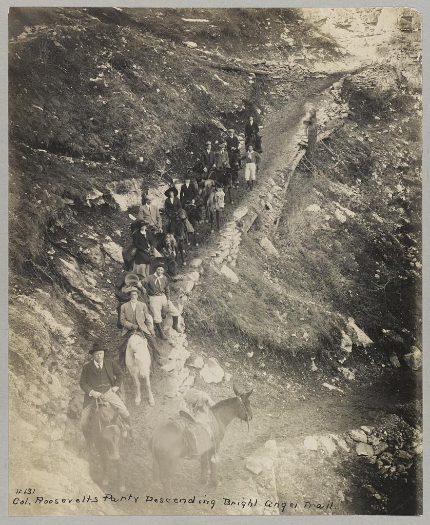
    <summary type="html"><![CDATA[<p><strong><em>President Theodore Roosevelt visits the Grand Canyon meeting the Havasupai Tribe. His efforts are making this landmark a National Park.</em></strong></p><img src="https://www.intermountainhistories.org/files/fullsize/81adde6a6a5c04daf97ec29b93d422ee.jpg" alt="Down a winding pathway, Theodore Roosevelt and others ride mules down Bright Angel Trail in the Grand Canyon" /><br/><p>Theodore Roosevelt traveled over 14,000 miles, visiting over 25 states, in the span of nine weeks in the early summer of 1903. His western tour was filled with speeches, commemorations, and his favorite thing to do: exploring the outdoors. His tours of Yosemite and Yellowstone are widely known, but in between them, he visited the Grand Canyon on May 6, 1903. He said, giving a speech, “In the Grand Canyon, Arizona has a natural wonder which, so far as I know, is absolutely unparalleled throughout the rest of the world.” Astounded, he said, “I shall not attempt to describe it, because I cannot. I could not choose words that would convey or that could convey to any outsider what that canyon is.” The majesty of Earth’s beauty there led him to explore more.
Riding a mule down Bright Angel Trail, he met two natives from the Havasupai tribe who lived in the Indian Garden with their families. For 1,000 years, the tribe lived in this region without outside contact, until Spanish priest Francisco Garces explored the area in 1776. As a result of the Santa Fe Railroad in the early 18th century, the Havasupai had increasingly more contact with other explorers and settlers. When Roosevelt and his regiment visited, he asked them to leave to make the canyon a National Park. To gain the status of a national park, all private development on the land would be illegal according to Congress. This resulted in the Havasupi’s relocation to a 518-acre reservation in Havasu Canyon instead.
Roosevelt was also concerned about the commercialization and exploitation of the land due to encroaching mining and timber interests. On June 8th, 1906, he signed the Antiquities Act, which authorized the president to “declare by public proclamation historic landmarks, historic and prehistoric structures, and other objects of historic or scientific interest that are situated upon the lands owned or controlled by the Government of the United States to be national monuments.” Subsequently, this act was used to establish the Grand Canyon National Monument on January 11th, 1908. It was made a National Park in 1919. Roosevelt Point and Trail were named in the President’s honor for the efforts he provided. A placard at Roosevelt Point reads another part from his speech advocating one request, “Leave it as it is. You can not improve on it. The ages have been at work on it, and man can only mar it. What you can do is to keep it for your children, your children's children, and for all who come after you, as one of the great sights which every American, if he can travel at all, should see.” Poetically, he wrote a letter to John Hay, former Secretary of State, summing up his experience on his Western tour and paying special attention to the Grand Canyon, “To me the most impressive piece of scenery I have ever looked at. I don’t exactly know what words to use in describing it. It is beautiful and terrible and unearthly. It made me feel as if I were gazing at a sunset of strange and awful splendor.” Today, almost 5 million tourists continue to explore this canyon that Roosevelt cared so profoundly to preserve.</p><p><em><strong><a href="https://www.intermountainhistories.org/items/show/924">For more (including 4 images) view the original article</a></strong></em></p>]]></summary>
    <published>2025-10-24T15:03:19+00:00</published>
    <updated>2026-08-18T15:52:34+00:00</updated>
    <link rel="alternate" type="text/html" href="https://www.intermountainhistories.org/items/show/924"/>
    <id>https://www.intermountainhistories.org/items/show/924</id>
    <author>
      <name>Jessika Cole, Brigham Young University</name>
    </author>
  </entry>
  <entry>
    <title type="html"><![CDATA[Teddy Roosevelt and John Muir Adventures in Yosemite: Story 3 of 8 of the President Theodore Roosevelt in the West Tour]]></title>
    <summary type="html"><![CDATA[<p><strong><em>President Theodore Roosevelt and his guide John Muir explored California’s beautiful National Park, Yellowstone, resulting in a nationwide conservation effort. </em></strong></p><img src="https://www.intermountainhistories.org/files/fullsize/091739d27efed8fc403fa07e54012ffd.jpg" alt="Theodore Roosevelt and John Muir pose in front of Glacier Point at Yosemite" /><br/><p>With a fondness for adventure, the outdoors, and the American West, President Theodore Roosevelt itched to experience the natural landscapes in California he’d heard so much about. Yosemite was one of only two national parks at the turn of the century, and he felt it fitting to include that stop in his 1903 Western tour. Roosevelt wrote a letter to John Muir, a Scottish botanist and conservationist who caught the President’s attention with his non-fiction novel “Our National Parks,” and asked him to be his guide. “I do not want anyone with me but you, and I want to drop politics absolutely for four days and just be out in the open with you.” Muir had an overseas journey planned in Europe and Asia at that time that he didn’t think he could cancel. After explaining the situation to the President of the University of California, Benjamin Ide Wheeler, he got an appeal and joined Roosevelt in the mountains, “I might be able to do some forest good in freely talking around the campfire,” Muir mused. As per Roosevelt’s request, politics were not discussed, but Muir’s agenda was nonetheless accomplished: to advocate for the land in the American West.
Roosevelt and his contingent arrived at Yosemite’s Wawona Hotel on May 15, 1903. With others remaining there, Muir, Roosevelt, a cook, two packers, and four mules left for the trees. They traveled through the giant sequoias, wandered through Mariposa Grove in the valley, and one night after camping at Glacier Point, they woke up to a blanket of snow, five inches atop them. If Roosevelt didn’t have forty wool blankets his men laid down for him and a warm fire by his side, he would have froze! Nonetheless, the men had great conversations. Charles Leidig was the cook and documented that “they talked a great deal about the conservation of forests in general and Yosemite in particular.” He also said, “he heard them discussing the setting aside of other areas in the United States for park purposes.” Muir had, indeed, done the “forest good.”
This trip jump-started Roosevelt's efforts to preserve public lands and natural resources across the nation. He was impressed to immediately go to Congress when returning to Washington and implement some of Muir’s ideas. He pushed for wildlife reserves, and on June 8, 1906, he signed the Antiquities Act which allowed the President to “declare by public proclamation historic landmarks” to be “national monuments, and may reserve as a part thereof parcels of land, the limits of which in all cases shall be confined to the smallest area compatible with proper care and management of the objects to be protected.” Roosevelt famously said in a speech in Sacramento after his experience in Yosemite, “We are not building this country for a day. It is to last through the ages.” Yosemite laid the groundwork for protecting other national forests in California and across the nation.</p><p><em><strong><a href="https://www.intermountainhistories.org/items/show/921">For more (including 3 images) view the original article</a></strong></em></p>]]></summary>
    <published>2025-10-24T15:03:18+00:00</published>
    <updated>2026-08-18T15:52:06+00:00</updated>
    <link rel="alternate" type="text/html" href="https://www.intermountainhistories.org/items/show/921"/>
    <id>https://www.intermountainhistories.org/items/show/921</id>
    <author>
      <name>Jessika Cole, Brigham Young University</name>
    </author>
  </entry>
  <entry>
    <title type="html"><![CDATA[Yellowstone’s Favorite President’s Monument: Roosevelt Arch: Story 1 of 8 of the President Theodore Roosevelt in the West Tour]]></title>
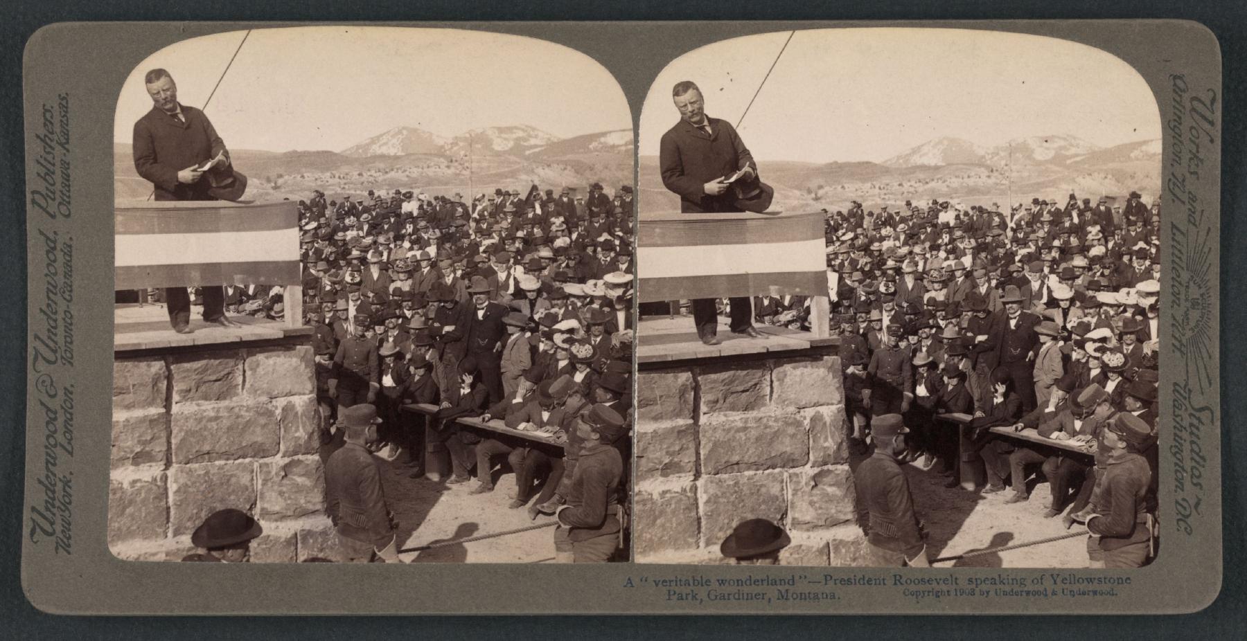
    <summary type="html"><![CDATA[<p><strong><em>Yellowstone receives an upgraded welcome with the Roosevelt Arch and gets a surprise visitor, Theodore Roosevelt, to dedicate it. </em></strong></p><img src="https://www.intermountainhistories.org/files/fullsize/f5ae52940338461ed18d1b83497abbb0.jpg" alt="President Roosevelt addresses a crowd at the dedication of Roosevelt Arch" /><br/><p>“Dedicated and set apart as a public park or pleasuring-ground for the benefit and enjoyment of the people.” Roosevelt Arch is a hearty welcome on the North entrance side of Yellowstone National Park. Standing at 52 feet, this monument is a symbol ofthe cultural and natural significance of the Park. Erected in 1903, the arch spanned what was at the time the park’s only entrance. Visitors passed under the arch from Gardiner, Montana, taking stagecoaches into Yellowstone. Army Co Engineer, Hiram M. Chittenden, the idea man, said, “...the natural features of the country at this portion of the boundary are about the least interesting of any part of the Park, and the first impression of visitors upon entering the Park was very unfavorable.” Accordingly, he proposed the arch as a beautiful park entry. Construction began on February 19, 1903 and a dedication ceremony was planned for April 24, 1903 to coincide with Roosevelt's planned visit to the park.</p><p>Yellowstone Park officials asked Roosevelt to participate in the event. This was a perfect opportunity for his conservation efforts and love for the park. With great fanfare, Roosevelt shared, “The geysers, the extraordinary hot springs, the lakes, the mountains, the canyons, and cataracts unite to make this region something not wholly to be paralleled elsewhere on the globe.” His love for the land was shared with the visitors there. They added a time capsule in the arch containing local newspapers, a bible, Masonic documents, a picture of President Roosevelt, and U.S. coins, among other items.
Roosevelt Arch still stands as a ceremonial welcoming committee to Yellowstone. Although not as popular as it was in the 20th century because of changing traffic patterns, automobiles couldn’t take the route like stagecoaches had, it is still a valuable spot to visit when exploring the park. Multiple entrances being added make this an out-of-the-way stop for those accessing the park from the more popular southern and western entrances. Yellowstone is visited by approximately 4 million people annually, and the arch continues to be a popular destination, especially for those visiting the Mammoth area or arriving from points north. It was added to the National Register of Historic Places in 2002 and is a potent symbol and reminder that National parks are “For the benefit and enjoyment of the people” as Theodore Roosevelt referenced the Act Congress passed in 1872 making Yellowstone a public park in his speech, and is not engraved on a place at the top of the arch itself.</p><p><em><strong><a href="https://www.intermountainhistories.org/items/show/919">For more (including 4 images) view the original article</a></strong></em></p>]]></summary>
    <published>2025-10-24T15:03:17+00:00</published>
    <updated>2026-08-18T15:51:51+00:00</updated>
    <link rel="alternate" type="text/html" href="https://www.intermountainhistories.org/items/show/919"/>
    <id>https://www.intermountainhistories.org/items/show/919</id>
    <author>
      <name>Jessika Cole, Brigham Young University</name>
    </author>
  </entry>
  <entry>
    <title type="html"><![CDATA[El Tovar Hotel - Grand Canyon National Park ]]></title>
    <summary type="html"><![CDATA[<p><strong><em>In 1901, the Atchison-Topeka Santa Fe Railway constructed a spur line from Williams, Arizona, that provided access to the Grand Canyon’s South Rim. El Tovar soon followed, providing its guests with the region’s first luxury accommodations.</em></strong></p><img src="https://www.intermountainhistories.org/files/fullsize/4856f91fdf081f933e9854aa688f9055.jpg" alt="El Tovar’s east side, circa 1905" /><br/><p><span style="font-weight:400;">Before the Atchison-Topeka Santa Fe Railway reached Grand Canyon Village in 1901, only a few rudimentary hotels served the Grand Canyon’s South Rim. These establishments relied on a local stagecoach line, which operated between Flagstaff, Arizona and a ranch near the rim. Because the twenty-dollar journey took three days to complete, the railroad provided a more efficient way to reach the canyon, and its arrival shifted the center of activity at Grand Canyon Village away from Thurston’s stagecoach line. Fred Harvey, a hospitality company whose Harvey houses provided quality food and lodging to passengers on the Santa Fe Railway, constructed El Tovar near the railroad tracks to draw in train passengers. The hotel cost $250,000 to construct, providing the Grand Canyon’s first luxury lodgings. </span>
<span style="font-weight:400;">Opened in 1905, El Tovar hotel predated the Grand Canyon’s designation as a national monument in 1908 and a national park in 1919. As a national monument, the Grand Canyon received less funding and attention than established national parks like Yellowstone. However, as tourism increased, calls for the area to receive further protections intensified. Ford Harvey, who served as president of the Harvey company until 1928, routinely advocated for Grand Canyon’s national park status at conferences. Conservation efforts gained strength when Arizona became a state in 1912, but many Grand Canyon residents opposed the national park proposal due to concerns about land and mineral rights. Regardless, President Woodrow Wilson officially signed the bill that established Grand Canyon National Park on February 26, 1919, and the Harvey company secured a hospitality contract from the new National Park Service (created in 1916) in 1920.</span>
<span style="font-weight:400;">Architect Charles Whittlesey’s design for El Tovar used the rustic architectural style, which aimed to establish a connection between buildings and their environment. Whittlesey designed the log siding on the first floor to resemble the wall of a log cabin. Natural building materials like rough stone and logs appear throughout the building, reinforcing this style. Whittlesey combined these rustic features with the architecture of traditional luxury resorts, which catered to Victorian tastes and a desire for exotic destinations. Decorative wooden poles known as balusters, which mimic Swiss chalet architecture, enclose El Tovar’s porches and balconies. The design also includes a small round tower known as a turret, which echoes resort architecture. </span>
<span style="font-weight:400;">El Tovar originally featured luxurious amenities, including hot running water and electric lighting. In the 1950s, the Harvey company added a new cocktail lounge to the hotel’s dining area. A 1983 renovation exchanged the hotel’s sparse public restrooms with private facilities, added carpeting, replaced windows, and included a new heating system. For this reason, El Tovar currently houses seventy-nine rooms instead of the original ninety-five. In 1968, Hawaii-based hospitality company Amfac purchased the Harvey company and gained control of El Tovar. In the 1990s, Amfac created Xanterra Parks and Resorts to control its concessions at the Grand Canyon, and Xanterra still manages El Tovar today. </span></p><p><em><strong><a href="https://www.intermountainhistories.org/items/show/840">For more (including 6 images) view the original article</a></strong></em></p>]]></summary>
    <published>2024-05-29T20:25:01+00:00</published>
    <updated>2026-04-17T19:32:19+00:00</updated>
    <link rel="alternate" type="text/html" href="https://www.intermountainhistories.org/items/show/840"/>
    <id>https://www.intermountainhistories.org/items/show/840</id>
    <author>
      <name>Kaylen Wilson, Northern Arizona University </name>
    </author>
  </entry>
  <entry>
    <title type="html"><![CDATA[Old Faithful Inn - Yellowstone National Park]]></title>
    <summary type="html"><![CDATA[<p><strong><em><span style="font-weight:400;">When the Northern Pacific Railroad’s Upper Geyser Basin Hotel burned to the ground on November 17, 1894, the U.S government pressured the railroad to replace it with new tourist accommodations. The result was Old Faithful Inn, which utilized a new style of architecture to highlight Yellowstone’s iconic landscape. </span></em></strong></p><img src="https://www.intermountainhistories.org/files/fullsize/eddddd6f4d185123b8615299ae39a69b.jpg" alt="Old Faithful Inn, Entrance Drive" /><br/><p><span style="font-weight:400;">On March 1, 1872, President Ulysses S. Grant officially signed Yellowstone into law as America’s first national park. The Yosemite Act of 1864 had restricted settlement in the Yosemite Valley and placed it under the jurisdiction of California’s state government, but the Yellowstone Park Act expanded upon this legislation by designating all of Yellowstone a public park. As a result, the Yellowstone Park Act contained many restrictions on private development and very few administrative procedures to enforce regulations or oversee public use. Poorly supervised independent companies called concessionaires, who paid park administrators a fee to use the land, ran Yellowstone’s public facilities. Only a few concessionaires ferried guests into the park, but the Northern Pacific Railroad quickly expressed interest in Yellowstone’s small tourism industry.</span>
<span style="font-weight:400;">When the Northern Pacific reached Gardiner, Montana, in the early 1880s, its presence provoked interest in Yellowstone’s tourism industry. At this time, only a few concessionaires opened small hotels and tent camps. One such concessionaire, the Yellowstone Park Improvement Company, constructed the Upper Geyser Basin Hotel in 1885 to preserve its failing business. The Northern Pacific purchased its properties in 1885, gaining control of the Upper Geyser Basin Hotel. When fire destroyed it</span><span style="font-weight:400;"> in 1894,</span><span style="font-weight:400;"> the importance of a new hotel in Yellowstone became clear</span><span style="font-weight:400;">. At the time</span><span style="font-weight:400;">, many railroad hotels utilized conventional architectural styles that provided a sense of familiarity for their upper-class audience. The Northern Pacific’s Lake Hotel, constructed in 1890, followed this example. However, </span><span style="font-weight:400;">rustic architecture, which emphasized harmony with the natural environment surrounding a structure, gained popularity in the 1890s. Because distinctive architecture drew more attention from visitors, the Northern Pacific experimented with a rustic style for its new hotel. </span>
<span style="font-weight:400;">The Yellowstone Park Association, a subsidiary of the Northern Pacific, selected Robert Reamer to design its new rustic hotel. The railroad constructed the log building near Yellowstone’s most famous geyser, from which the Old Faithful Inn derived its name. </span><span style="font-weight:400;">The Union Pacific completed the central core of the hotel, known as the “Old House,” in 1903.</span><span style="font-weight:400;"> The finished building was seven stories tall at its highest point, and it cost a total of $140,000 (about $4.9 million today) to construct. The Northern Pacific set aside a further $25,000 (approximately $875,000 today) to furnish the new hotel. Reamer designed his massive log structure to emulate Swiss chalets and Norwegian villas, and he utilized rough, unfinished wood logs obtained in the Park on both the inside and outside of the building to connect it to Yellowstone’s forested landscape. The hotel’s most prominent feature is its seven-story lobby, which features a vast fireplace made of native stone. A complex log frame that supports the hotel’s roof surrounds this room. The structure’s use of exposed wooden supports emphasizes the rustic nature of the lobby, and a series of wooden balconies overlook the main floor of the hotel. </span></p><p><em><strong><a href="https://www.intermountainhistories.org/items/show/839">For more (including 5 images) view the original article</a></strong></em></p>]]></summary>
    <published>2024-05-29T19:43:03+00:00</published>
    <updated>2026-04-17T19:32:19+00:00</updated>
    <link rel="alternate" type="text/html" href="https://www.intermountainhistories.org/items/show/839"/>
    <id>https://www.intermountainhistories.org/items/show/839</id>
    <author>
      <name>Kaylen Wilson, Northern Arizona University</name>
    </author>
  </entry>
  <entry>
    <title type="html"><![CDATA[Shadow Mountain Lookout]]></title>
    <summary type="html"><![CDATA[<p><strong><em>This prime example of “parkitecture” offers both great views and rich architectural history.</em></strong></p><img src="https://www.intermountainhistories.org/files/fullsize/3c4e4b3b2596c254063f778413d4b7ba.jpg" alt="The Shadow Mountain Fire Lookout" /><br/><p><p style="font-weight:400;">By the beginning of the twentieth century, the environment had become an increasingly contentious topic. Led by President Theodore Roosevelt and Chief of the Forest Service, Gifford Pinchot, the conservation movement put utilitarian environmental protection at the front of the American public’s collective mind. The conservationist fervor was especially present in Colorado. This encouraged Congress to grant the Mesa Verde cliff dwellings, located in southwestern Colorado, status as a National Park in 1906. One central Colorado local and avid naturalist, Enos Mills, made it his mission to advocate for park status for a pristine set of peaks along the Rocky Mountains. After Mills campaigned for years, President Woodrow Wilson signed Rocky Mountain National Park into existence in 1915.
<p style="font-weight:400;">From the park’s beginning, wildfire suppression was a top priority. During the park’s first decade, rangers used high mountain tops to monitor the surrounding forests. In 1924, one ranger established a crude and difficult trail to the top of Shadow Mountain to be used for fire surveillance. However, the trail was far too rugged, and in 1930 the Park developed a trail from a nearby lake to the peak of the mountain. The lakes surrounding the peak were popular tourist destinations, and Park visitors soon took to scaling the trail to enjoy the views from the top. This early lookout consisted of little more than a telephone wire running down the steep mountainside and a campsite. The bare site proved successful, however, and the following year the Park Service began construction on a permanent lookout.
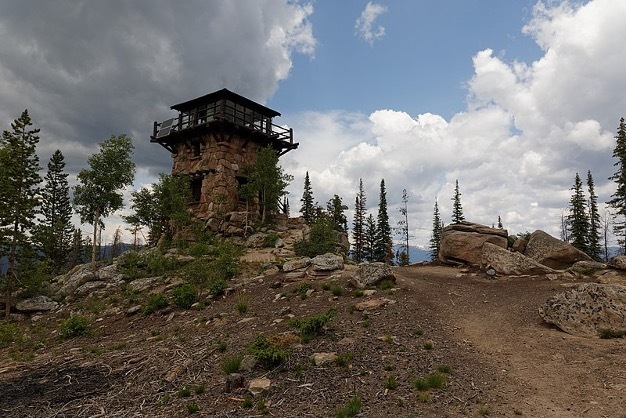
<p style="font-weight:400;">Rocky Mountain National Park completed the Shadow Mountain Lookout in 1933. Considering the number of visitors that would interact with the tower given the trail’s popularity, the Service constructed with aesthetics in mind, using the National Park Service rustic, or  “parkitecture”. This style utilized locally sourced materials that blended into the surrounding landscape. Parkitecture structures are meant to reflect rustic cabins more than bureaucratic facilities. With two lower stories consisting of unprocessed stone masonry and an upper story of evergreen frame, the Shadow Mountain Lookout is a prime example of parkitecture. Park supervisors expected lookouts manning the tower to participate in public relations just as much as fire suppression. In fact, the lower level of the structure acted as a museum, with exhibits concerning park wildlife and fire information.
<p style="font-weight:400;">Today, Shadow Mountain houses the only remaining lookout in Rocky Mountain National Park. Though the interior of the tower is currently closed to the public, the site is accessible by two trails on either side of the mountain. The peak of Shadow Mountain offers impressive views. The Park Service simply asks that hikers watch out for storms, as lightning can pose a danger on exposed mountaintops.</p><p><em><strong><a href="https://www.intermountainhistories.org/items/show/710">For more (including 4 images) view the original article</a></strong></em></p>]]></summary>
    <published>2023-02-23T19:13:08+00:00</published>
    <updated>2026-04-17T19:32:15+00:00</updated>
    <link rel="alternate" type="text/html" href="https://www.intermountainhistories.org/items/show/710"/>
    <id>https://www.intermountainhistories.org/items/show/710</id>
    <author>
      <name>Tanner Hammarstrom, Northern Arizona University</name>
    </author>
  </entry>
  <entry>
    <title type="html"><![CDATA[Grand Canyon Depot]]></title>
    <summary type="html"><![CDATA[<p><strong><em>Take the Grand Canyon Railway to the historic train depot in Grand Canyon National Park and experience the unique architectural design of the only operating log depot in the United States.</em></strong></p><img src="https://www.intermountainhistories.org/files/fullsize/f9bfc58de0278251fc6045574c950f38.jpg" alt="The depot in 1975" /><br/><p>Designed by architect and Santa Barbara, California native Francis W. Wilson, the Grand Canyon Train Depot is one of fourteen log depots ever constructed in the United States and is now one of only three remaining. Out of these, the Grand Canyon Depot is the only one built mainly from logs and the only one still operating today. The building features a central two-story section and a wing on each side one-story in height. The unique design of the wood—three flat sides and one rounded—allowed the building to give off a frontier appearance while keeping out moisture and maintaining structural integrity. The original copper lettering on the front spelled out “Grand Canon,” but workers replaced it in 1911 to spell “Grand Canyon.” Between the late-1920s and mid-1950s the depot underwent structural and functional renovations which added office space and upgraded lighting.
Before 1901, a trip to the Grand Canyon required a bumpy, sixty-five-mile stagecoach ride on dirt roads to reach the South Rim. To rectify this—and simultaneously capitalize on interest to the park—in 1901, the Santa Fe Railway built a line of tracks connecting their depot in Williams, Arizona to what would become Grand Canyon Village. Instead of going by stagecoach, visitors to the Grand Canyon could ride the train and relax while enjoying the view on the way to one of the greatest natural wonders in the world.
The arrival of the railroad in 1901 shifted the tourist experience to what became the Grand Canyon Village. In 1905, the Santa Fe Railroad completed the El Tovar Hotel between the track and the canyon. Santa Fe then partnered with the Fred Harvey Company and the National Park Service to add more buildings to accommodate the growing number of tourists, including Hopi House, Bright Angel Lodge, and the Red Horse Cabin. Architect Mary Jane Colter designed many of these structures.
Popularity for the railroad dwindled as the automobile industry grew, however; in 1968, the Grand Canyon Railway made its final passenger run, and the Santa Fe Railway left the buildings it owned to the National Park Service. Freight transportation continued on the line, but soon after, in 1972, the railway discontinued passenger services to the Grand Canyon. In 1989 the formation of the Grand Canyon Railway revived the route when entrepreneurs Max and Thelma Biegert funded the restoration of the Grand Canyon Line: tourists once again could travel to the park by train. For visitors today, the station represents the idea of western national parks as rustic and scenic. Often the first experience guests have when they step off the train, the depot remains one of the best structures from the National Park’s rustic period.</p><p><em><strong><a href="https://www.intermountainhistories.org/items/show/603">For more (including 4 images) view the original article</a></strong></em></p>]]></summary>
    <published>2022-06-09T22:59:59+00:00</published>
    <updated>2026-04-17T19:32:13+00:00</updated>
    <link rel="alternate" type="text/html" href="https://www.intermountainhistories.org/items/show/603"/>
    <id>https://www.intermountainhistories.org/items/show/603</id>
    <author>
      <name>Jennifer John, Northern Arizona University</name>
    </author>
  </entry>
  <entry>
    <title type="html"><![CDATA[Zion Lodge]]></title>
    <summary type="html"><![CDATA[<p><strong><em>There are sixty-one registered historic structures in Zion National Park, the buildings of the Zion Lodge complex being among them.</em></strong></p><img src="https://www.intermountainhistories.org/files/fullsize/b99f86cd2dbd3a60e1905a3de5eb0e89.jpg" alt="Probable dedication of Zion Lodge" /><br/><p>The Union Pacific Railroad and its subsidiary, the Utah Parks Company, completed a railway line near Cedar City in 1923, granting visitors of Zion National Park an easy and convenient method of travel from the railway station to the park by motorbus. The Union Pacific also collaborated with the Park Service to build hotels along its routes to attract customers for each company, resulting in the construction of Zion Lodge, an in-park hotel where guests could stay during their travels. Stephen Mather, director of the National Park Service, initially balked at Union Pacific’s desired size for the lodge and requested something smaller. In the end, each side compromised to build a medium-sized lodge that blended into its natural surroundings inside the heart of the canyon. 
Gilbert Stanley Underwood, an American architect who studied at Yale and Harvard, worked with the Utah Parks Company to design the structure, and construction began in 1923. Underwood envisioned the lodge as a warm and inviting atmosphere for guests. The building incorporated 265,000 board feet of lumber from the Colorado Plateau brought down by the Cable Mountain Draw Works, a mechanism of wires and pulleys extending from the top of the canyon to an area 2,000 feet below. Construction teams finished the lodge in May 1925, and the park held a small dedication ceremony on the front lawn. The later addition of individual cabins to the lodging accommodations in Zion signaled a milestone in park success and development.
The original lodge featured natural wood design, locally sourced stone for the entrance columns, and a green roof that harmonized the building with its surrounding canyon and forest environment. The original structure served visitors and staff for over forty years until it was lost to a fire on January 26, 1966. But in only 108 days, crews constructed a new building to replace the original lodge. The new lodge continues to offer a variety of accommodations.
In addition to being the only place inside Zion that serves food, at the lodge visitors can also attend or embark on ranger-led activities such as patio talks, guided hikes, shuttle bus tours, and outdoor evening programs. To access the lodge, visitors who are staying overnight must present a permit that allows car access up the Zion Canyon Scenic Drive. Otherwise, catching a ride on the shuttle takes visitors to the lodge and nearby trailheads. The park’s swift move to replace Zion Lodge after the fire and maintain accommodations shows the Service’s commitment to visitors and the importance of the lodge to Zion National Park.</p><p><em><strong><a href="https://www.intermountainhistories.org/items/show/602">For more (including 4 images) view the original article</a></strong></em></p>]]></summary>
    <published>2022-06-09T22:21:29+00:00</published>
    <updated>2026-04-17T19:32:13+00:00</updated>
    <link rel="alternate" type="text/html" href="https://www.intermountainhistories.org/items/show/602"/>
    <id>https://www.intermountainhistories.org/items/show/602</id>
    <author>
      <name>Jennifer John, Northern Arizona University</name>
    </author>
  </entry>
  <entry>
    <title type="html"><![CDATA[Moraine Park Museum and Amphitheater]]></title>
    <summary type="html"><![CDATA[<p><strong><em>Catch the morning sun at the Moraine Park Amphitheater and enjoy a view of Longs Peak in the distance.</em></strong></p><img src="https://www.intermountainhistories.org/files/fullsize/4a03e1b6c12de566555b8cbb98c72010.jpg" alt="Moraine Amphitheater" /><br/><p>In the 1930s, the Civilian Conservation Corps removed Moraine Lodge from Rocky Mountain National Park in an initiative to restore the land to its original state. They converted the lodge’s remaining assembly hall into a museum in 1936 and the following year added the Moraine Park Museum Amphitheater. Like other outdoor venues in the national parks, the amphitheater follows Greek design with a rustic naturalism that blends in with the setting. The architecture plays a subordinate role to nature, responding to the terrain rather than controlling it, by following basic principles such as refraining from removing large numbers of trees to create seating, incorporating a distant natural view as the stage background, and placing a campfire near the stage. The amphitheater also reflects the ‘Parkitecture’ era of Park Service design that naturalized visitor centers, creating an organic aesthetic for guests that blended manmade structures with nature.
Overlooking a view of Longs Peak, the amphitheater features rustic design elements like the plank and stone seating built around the topographic shape of the bowl, ponderosa pines creating a wall around the stage, and stone steps and trails for pedestrian traffic. The new museum and theater were important additions to the Park Service’s education and interpretation programs at Rocky Mountain and served as a venue for delivering slideshow presentations. The first lecture took place in the summer of 1937 and hosted 97 guests. The <em>Estes Park Trail</em>—a local newspaper—published a list of weekly programs held at the amphitheater which included motion pictures like <em>Glimpses of the National Parks</em> and campfire lectures such as “Oddities in Nature’s Gardens” and “Winter Life in the Rockies,” both given in the week of July 25, 1938.
The Moraine Park Museum Amphitheater site is one of the best representations of National Park rustic design and remains unchanged to this day. Using the natural landscape, retaining native plants, and including views of the park were key elements of the Park Service’s conservation movement in the 1930s. Citizens nominated the site to the National Register of Historic Places in 1976, and promoted understanding landscapes as places of historical information.
Since its original construction, the National Park Service replaced the amphitheater’s stone seating with wood planks in the 1950s. The amphitheater has hosted many events over the years, ranging from lectures and religious gatherings to stargazing and campfires. It remains in use today largely for weddings and school education programs.</p><p><em><strong><a href="https://www.intermountainhistories.org/items/show/601">For more (including 3 images) view the original article</a></strong></em></p>]]></summary>
    <published>2022-06-09T22:08:39+00:00</published>
    <updated>2026-04-17T19:32:13+00:00</updated>
    <link rel="alternate" type="text/html" href="https://www.intermountainhistories.org/items/show/601"/>
    <id>https://www.intermountainhistories.org/items/show/601</id>
    <author>
      <name>Jennifer John, Northern Arizona University</name>
    </author>
  </entry>
  <entry>
    <title type="html"><![CDATA[Beaver Creek Administrative Area Historic District Cultural Landscape]]></title>
    <summary type="html"><![CDATA[<p><strong><em>Explore the beautiful mountain range of Grand Teton National Park and sneak a peek at exemplary rustic architecture while there. </em></strong></p><img src="https://www.intermountainhistories.org/files/fullsize/50f5f2bba465e7d5d66e479abeb52569.jpg" alt="Superintendent’s residence" /><br/><p>The first development at the Beaver Creek Administrative Area in what became Wyoming’s Grand Teton National Park was in 1908, when Forest Service ranger Al Austin built the Stewart Ranger Station in what was then known as Teton National Forest. Between 1908 and 1929, there were a few small additions to the landscape, including three buildings, a road, fencing, and a flagpole. When Grand Teton became a National Park in 1929, the National Park Service took over the land and used it as a utility and administrative site. The 1930s brought new infrastructure to the park which conformed to the Park Service’s rustic building style. With funds from the New Deal program, the Park Service had a superintendent residence built, and they designed this first construction in the area to look rustic. The Civilian Conservation Corps added log cabins, garages, and buildings to the landscape. In addition, replanting natural vegetation was key to blending human development with the region’s natural aesthetic. 
The Beaver Creek Administrative Area continued to serve as the park’s headquarters from 1929 until 1958, when a new site near Moose, Wyoming replaced it. The original administrative area remains one of the easiest-to-identify National Park Service rustic sites in the United States. The use of unprocessed building materials like the lodgepole pine trees and river stones create a sense that the building grew directly out of the landscape, and the dark brown paint and green-rolled asphalt roofing meld the buildings with the natural color palette of the Teton forest. The absence of decorative design helps these man-made structures further blend into their environment. The Forest Service buildings that remain in Beaver Creek have undergone renovations since their construction in 1908 which combined the two log buildings into one under a new roof and added porches to the east and west sides of the structure.
The historic administrative area has been a topic of debate for Grand Teton National Park in years past. The buildings are still in use as housing, offices, and storage, but the NPS believes the area is an opportunity to showcase National Park designed rustic architecture. Accommodating both tourism and administrative operation requires conscience respect for the the size and design of the historic district. These buildings stand the test of time and exemplify the conservation movement and rustic architecture that the National Parks strove for in the 1930s.</p><p><em><strong><a href="https://www.intermountainhistories.org/items/show/600">For more (including 3 images) view the original article</a></strong></em></p>]]></summary>
    <published>2022-06-09T20:57:46+00:00</published>
    <updated>2026-04-17T19:32:13+00:00</updated>
    <link rel="alternate" type="text/html" href="https://www.intermountainhistories.org/items/show/600"/>
    <id>https://www.intermountainhistories.org/items/show/600</id>
    <author>
      <name>Jennifer John, Northern Arizona University</name>
    </author>
  </entry>
  <entry>
    <title type="html"><![CDATA[Grand Canyon Lodge]]></title>
    <summary type="html"><![CDATA[<p><strong><em>Take a trip down US Highway 64 to the Grand Canyon’s North Rim and find yourself greeted by the marvelous front entrance of the Grand Canyon Lodge.</em></strong></p><img src="https://www.intermountainhistories.org/files/fullsize/d31bf7b7b8601221ce5830499cba07b3.jpg" alt="Welcome to the Grand Canyon" /><br/><p>In the 1920s, the National Park Service gave the first permanent concession on the North Rim of the Grand Canyon to the Union Pacific Railroad and its subsidiary Utah Parks Company. From 1901, the railroad provided transportation for tourists to the South Rim of the canyon but did not reach the North Rim directly. To help tourists reach the North Rim, Union Pacific eventually established a railway station one-hundred miles away at Cedar City, Utah, and they provided motor coaches that could then take tourists to one of three parks: Bryce Canyon, the Grand Canyon, and Zion National Park. In the 1920s, new modes of transportation sparked the need for accommodations on the North Rim, and late in the decade the National Park Service contracted private architect Gilbert Stanley Underwood to design and construct the Grand Canyon Lodge to the rustic requirements of park architecture, or <em>parkitecture</em>. Instead of making a single, simple lodge, Underwood envisioned a community of cabins with the lodge as its centerpiece. A crew of just over a hundred men worked through the winter of 1927–1928 to complete the site; each laborer earned anywhere from fifty to eighty-five cents per hour. 
The original lodge featured Kaibab limestone on the exterior designed to resemble natural rock formations, making the lodge appear to rise directly out of the canyon. The glass-enclosed interior faced south, giving visitors inside a direct view of the chasm and of the exterior terrace with its observation tower.
On September 1, 1932, tragedy struck in the late hours of the night; a fire took down the lodge in minutes. Luckily, the lodge had not been used as a hotel, and the only employees inside made it out in time. All but four of the surrounding cabins survived the blaze, and the Park Service still actively uses these cabins today, though the Great Depression slowed progress on repairs. Four years passed before the Park began building a new lodge in 1936, and workers finished it in July 1937. Laborers made use of the surviving materials from the lodge and reconstructed the exterior with Kaibab limestone to maintain the original flow of the lodge with the canyon below. The architects also took advantage of the remodel to add steeper roof lines to better withstand the winter snow and to rebuild with materials that could tolerate fire.
The National Park Service’s Mission 66 program in the 1950s and 1960s raised questions about repurposing the lodge into a visitor center and building motels on the North Rim, but this plan proved too expensive and was never brought to fruition. The lodge has undergone changes in ownership through the years but remains physically unchanged since 1937. Despite being a replacement, architects consider it to be one of the most intact rustic lodge complexes to survive in the National Parks, and in 1987 the Secretary of the Interior designated it a National Historic Landmark.</p><p><em><strong><a href="https://www.intermountainhistories.org/items/show/599">For more (including 3 images) view the original article</a></strong></em></p>]]></summary>
    <published>2022-04-28T02:58:40+00:00</published>
    <updated>2026-04-17T19:32:13+00:00</updated>
    <link rel="alternate" type="text/html" href="https://www.intermountainhistories.org/items/show/599"/>
    <id>https://www.intermountainhistories.org/items/show/599</id>
    <author>
      <name>Jennifer John, Northern Arizona University</name>
    </author>
  </entry>
  <entry>
    <title type="html"><![CDATA[Desert National Wildlife Refuge and the Nuwu (Paiute)]]></title>
    <summary type="html"><![CDATA[<p><strong><em>Franklin D. Roosevelt ordered the creation of a wildlife refuge that protects indigenous interests to this day. The Nuwu have deep roots in the land and wildlife.</em></strong></p><img src="https://www.intermountainhistories.org/files/fullsize/67316c1bf67beb12e1b4428a319d2fe2.jpg" alt="Desert National Wildlife" /><br/><p>Desert National Wildlife Refuge is the largest wildlife refuge in the continental United States, spreading over 1.6 million acres of land and six different mountain ranges in Southern Nevada within the Clark, Lincoln, and Nye Counties. President Franklin D. Roosevelt created the refuge by executive order in 1936, and at that time federal protection spanned the entirety of the current Desert National Wildlife Refuge, Mount Charleston, and much of today’s Red Rock National Recreation Area. The need for protection stemmed from the steeply declining population of native plants and animals, specifically desert bighorn sheep.
Desert National Wildlife Refuge includes lands sacred to the Nuwu, also known as the Southern Paiutes. The land is the setting of Nuwu origin stories and legends as well as the lands their people lived in and thrived upon for many generations. Artifacts of the Paiutes are scattered across the land and are sacred to local Paiute communities. Greg Anderson, Chairman of the Moapa Band of Paiutes says, “We honor these gifts through the many songs we sing that talk about the natural landscape that bestows food, medicine, wildlife, water and the air we breathe. We connect to the loves, joys and struggles of our many ancestors who were here long before us.” They still practice Nuwu traditions tied to the land, which makes preserving it important to keeping traditions alive.
The Desert National Wildlife Refuge is also important to the Nuwu people because it is the natural habitat of the desert bighorn sheep, or <em>nah’gah</em> to use the Paiute name. The nah’gah were one of the Nuwu’s main food sources. Paiute legends tell how their people were starving and the desert bighorn sheep stepped forward and sacrificed their lives so the people could survive. Nuwu view the nah’gah as protectors of their people include giving them power and energy and guiding them through drought and disease. The Nuwu strive to protect the desert bighorn sheep because they believe their people are tied to them and if they die then the Nuwu people will die as well. To this day, the Nuwu honor the nah’gah through stories, songs, and dances.</p><p><em><strong><a href="https://www.intermountainhistories.org/items/show/589">For more (including 3 images) view the original article</a></strong></em></p>]]></summary>
    <published>2022-04-09T19:28:49+00:00</published>
    <updated>2026-04-17T19:32:12+00:00</updated>
    <link rel="alternate" type="text/html" href="https://www.intermountainhistories.org/items/show/589"/>
    <id>https://www.intermountainhistories.org/items/show/589</id>
    <author>
      <name>Amanda Reece, Brigham Young University</name>
    </author>
  </entry>
  <entry>
    <title type="html"><![CDATA[Big Horn Medicine Wheel]]></title>
    <summary type="html"><![CDATA[<p><strong><em>In a picturesque and seemingly significant location, the Big Horn Medicine Wheel may reveal indigenous knowledge of astronomy.</em></strong></p><img src="https://www.intermountainhistories.org/files/fullsize/e3c611b4ff4e6359f87c4c7f5dede281.jpg" alt="Big Horn Medicine Wheel" /><br/><p>At the top of the Big Horn Mountains, 9,642 feet above sea level, on the west ridge of Medicine Mountain, lies the Big Horn Medicine Wheel. The wheel sits about twenty yards away from a limestone cliff face, where visitors can look down upon the Big Horn Basin, the Wind River, and the Pryor Mountains of Montana. Using a piece of wood found built into the structure, archaeologists dated the Medicine Wheel itself to around 1760 AD. Other archaeological research carbon-dated charcoal and wood fragments found near the Medicine Wheel to 4,529 BCE.
The wheel is made of hundreds of white limestone rocks arranged in roughly in the circular shape of a wheel. Spanning eighty feet in diameter, the wheel is a true marvel, as most rocks used as material for the massive wheel originate from the bottom of the mountain, meaning the builders carried them to the top. At the center of the wheel lies another smaller circle, and 28 “spokes” radiate from this smaller center circle, connecting the center to the perimeter of the wheel. Small hollow cairns surround the wheel.
Although much research has been done on the wheel, archaeologists, astronomers, and other scholars have been unable to determine its origin and function. One astronomer suggests the indigenous builders might have designed the wheel to track celestial bodies, having found the cairns are in astronomical alignment with the summer solstice sunset and sunrise as well as the rise of the stars Alderbaran, Serius, and Rigel. Another astronomer disagrees, saying that had the medicine wheel’s purpose been to track the solstice and stars, the structure’s design would have been more precise and astronomical alignments with the wheel would be more obvious and practical. An archaeologist suggests that the cairns could have been small shelters for vision quest participants while another archaeologist believes the wheel is a model of a Cheyenne medicine lodge. A Crow legend tells the story of a boy that was able to find healing and tribal acceptance through the power connected to the wheel. The Cheyenne believe that the Legend of Sweet Medicine inspired the Big Horn Medicine Wheel. Many theories have been proposed and disputed, but no theory has provided irrefutable evidence for a single explanation.
The Big Horn Medicine Wheel is a national historical landmark and is still used by tribes for religious purposes. Visitors are allowed to view the Big Horn Medicine Wheel but are asked to respect the ancient site as it holds both religious and historical significance to many Native Americans.</p><p><em><strong><a href="https://www.intermountainhistories.org/items/show/582">For more (including 5 images) view the original article</a></strong></em></p>]]></summary>
    <published>2022-03-19T10:04:39+00:00</published>
    <updated>2026-04-17T19:32:12+00:00</updated>
    <link rel="alternate" type="text/html" href="https://www.intermountainhistories.org/items/show/582"/>
    <id>https://www.intermountainhistories.org/items/show/582</id>
    <author>
      <name>Kelli Holiday, Brigham Young University</name>
    </author>
  </entry>
  <entry>
    <title type="html"><![CDATA[Devils Tower National Monument]]></title>
    <summary type="html"><![CDATA[<p><strong><em>Devils Tower is a sacred site for Lakotas and Kiowas. Though designated a U.S. national monument, it still occupies a holy place in modern Indigenous beliefs.</em></strong></p><img src="https://www.intermountainhistories.org/files/fullsize/f3dff2d8b50dc270a78c54e5c3344257.jpg" alt="Devils Tower,  Bear Lodge" /><br/><p>In Wyoming’s Black Hills stands a massive geological monument called Devils Tower. To the Northern Plains tribes—the Lakotas, Arapahos, Cheyennes, Shoshones, Crows, and Kiowas—this monument is known by older names: Bear Lodge, Bear’s Tipi, Bear Peak, and Tree Rock. Like its names, the views and value of the Tower differs between U.S. American and Indigenous peoples.
Devils Tower is a magma pillar which cooled underground until erosion over geologic time exposed it. Scientists have studied the formation since the 1880s and still do not fully agree on the processes. In 1906, President Theodore Roosevelt designated Devils Tower as the first U.S. National Monument. Among its 400,000 visitors annually, rock climbers enjoy the unique challenge of scaling its large column formations.
To indigenous peoples, Bear Lodge has a rich spiritual history and significance. A Lakota elder, Johnson Holy Rock, said when asked about the region, “If a man was starving, he was poor in spirit and in body, and he went into the Black Hills, the next spring he would come out, his life and body would be renewed. So, to our grandfathers, the Black Hills was the center of life, and those areas all around it were considered sacred, and were kept in the light of reverence.”
The Lakotas and Kiowas recount the creation of the Tower by telling of a group of little girls playing in the Plains who ran as bears chased them. The Great Spirit had pity on them and made the earth beneath them rise into a large tower, protecting them from the bears as they tried to claw their way up, to no avail. Their claw marks are seen today as great columns on the sides of the mountain.
A Cheyenne warrior, Wooden Leg, once told a story of a man who fell asleep next to a buffalo head at the base of Bear Lodge. While asleep, he and the buffalo head were miraculously transported up the tower by the Great [Spirit] Medicine. When the man woke up, he feared he had no way down, so he prayed. When he woke up the next morning, the Great Spirit had transported him to the bottom of the tower, leaving the buffalo head at the top, where it has remained since then. Many important spiritual leaders have visited Bear Lodge, fasting, praying, and receiving visions and prophecies during their time there, including the Cheyenne Sweet Medicine, the Lakota Sitting Bull, and Crazy Horse.
Northern Plains tribes hold Bear Lodge in great reverence by performing prayers and ceremonies nearby. Around the monument, signs are posted which read, “Please do not disturb prayer bundles and prayer cloths.” Native peoples leave prayer offerings near the surrounding trails. Traditionally, the Lakota held a Sun Dance at Bear Lodge at the time of the summer solstice. This dance focuses on symbolic sacrifice and renewal of man and nature and is sometimes still performed at Bear Lodge.
According to the Northern Plains Native American tribes, Devils Tower is much more than a national monument, unique geological formation, or great place to rock climb. To them, Bear Lodge represents a place to worship, pray, and receive spiritual experiences.</p><p><em><strong><a href="https://www.intermountainhistories.org/items/show/578">For more (including 3 images) view the original article</a></strong></em></p>]]></summary>
    <published>2022-03-12T09:29:23+00:00</published>
    <updated>2026-04-17T19:32:12+00:00</updated>
    <link rel="alternate" type="text/html" href="https://www.intermountainhistories.org/items/show/578"/>
    <id>https://www.intermountainhistories.org/items/show/578</id>
    <author>
      <name>Leah Waldrop, Brigham Young University</name>
    </author>
  </entry>
  <entry>
    <title type="html"><![CDATA[Conflict, the Crow, &amp; Bighorn Canyon National Recreation Area]]></title>
    <summary type="html"><![CDATA[<p><strong><em>Bighorn Canyon National Recreation Area, which extends between Montana and Wyoming, has plenty of beautiful scenery to enjoy, especially its recreational opportunities on the water, made possible by the Yellowtail Dam. Additionally, the canyon has a rich history extending back thousands of years, and the right to its usage has always been part of the story.</em></strong></p><img src="https://www.intermountainhistories.org/files/fullsize/12b26f748b2756ade61e702354e7b22a.jpg" alt="Yellowtail Dam" /><br/><p>The oldest feature in Bighorn Canyon is the 10,000-year-old walking trail that indigenous Plains people once traversed. Extending all the way to the Wind River mountains in the south, this trail serves as a reminder that humans used the canyon and its resources long before it became the recreation area of today.
The Crow people’s relationship with Bighorn Canyon extends to the very beginnings of their own histories, and the Crow consider the land to be an inseparable part of their heritage. The canyon gains its name from the legend of Big Metal, in which the metal-horned and hooved chief of the bighorn sheep tells a rescued boy, Big Iron, that the canyon must never lose the name “Bighorn” or the Crow people will cease to exist. Records show that the modern Crow took up residence in the canyon in the early 1700s.
However, the Crow found themselves facing conflict from many different groups. Other tribes wanted access to the canyon’s rich hunting grounds, and the Crow warred with many of them. Among these tribes were the Sioux and the Cheyenne, who the Crow continued to find themselves at odds with as United States colonization encroached on their territory. The Sioux and Cheyenne fought against the US Army defend their lands while the Crow tried to preserve their territory by negotiating with the United States and acting as guides and mail carriers.
As white settler encroachment in the area escalated during the nineteenth century, so did the ire of many Plains tribes, were rapidly pushed out of their lands by the whites. Montana boundary disputes increased the already present tensions between settlers and Plains peoples. The federal government designated large segments of Montana land as Crow territory in 1851, part of which became the Crow Reservation in 1868, but nearby miners refused to honor these secessions. Bands of Sioux, Cheyenne, and Arapahoe rallied together to fight back against this encroachment. Facing old foes once again, the Crow chose to ally with US troops, even fruitlessly warning Custer of his odds before the Battle of Little Bighorn. In exchange, the government promised the Crow land rights in the Bighorn area.
In 1966, five years after the groundbreaking on Yellowtail Dam, Bighorn Canyon became an official national recreation area. However, the park’s coverage included some Crow reservation land that the Bureau of Reclamation had previously acquired. In 1967, the Crow requested the return of land surrounding the newly completed Yellowtail Dam reservoir and the two entities formed a joint arrangement. Though this area still lies within the park’s boundaries, the Crow people retain control over assets such as the sale of fishing and hunting licenses and manage a fairly cooperative relationship with state and federal governments. The story of the Crow people shows that tribal history is not unilateral: rather, it is a complex series of relationships, with the land always at the center.</p><p><em><strong><a href="https://www.intermountainhistories.org/items/show/548">For more (including 3 images) view the original article</a></strong></em></p>]]></summary>
    <published>2021-12-17T03:03:01+00:00</published>
    <updated>2026-04-17T19:32:11+00:00</updated>
    <link rel="alternate" type="text/html" href="https://www.intermountainhistories.org/items/show/548"/>
    <id>https://www.intermountainhistories.org/items/show/548</id>
    <author>
      <name>Len Truelsen, Northern Arizona University</name>
    </author>
  </entry>
  <entry>
    <title type="html"><![CDATA[Dark Sky over Bryce Canyon National Park]]></title>
    <summary type="html"><![CDATA[<p><strong><em>A national park filled with crimson rock formations known as hoodoos, Bryce Canyon also has one of the best-sustained public astronomical programs, and it has been running for over fifty years.</em></strong></p><img src="https://www.intermountainhistories.org/files/fullsize/2988e0f433f61569bc6c5beafc753df2.jpg" alt="Milky Way over Bryce Canyon" /><br/><p>In addition to hosting the longest active program for astronomy in the National Park Service, Byce Canyon National Park also holds the honor of being a Gold Tier International Dark Sky Park, so designed by the International Dark-Sky Association in 2019. Gold Tier is a rare classification, as it denotes a place with natural nighttime conditions, little to no light pollution, and over 10,000 stars visible on a clear night.</p><p>President Warren G. Harding made Bryce Canyon a National Monument on June 8, 1923, but after a review, Congress made it a national park on February 25, 1928. Educational programs in Bryce Canyon National Park in Utah to teach visitors about astronomy began in 1969 when the Chief of Interpretation was inspired by the Abrams Planetarium to create a night sky interpretation program for Bryce Canyon. In 1972, an astronomer named Von Del Chamberlain wrote and designed a manual for sky interpretation for distribution and use at Bryce Canyon National Park. Chamberlain’s manual included cartoons about why natural skies were culturally important, a list of seven reasons for the park to include sky interpretation, and several program ideas focusing on campfires and storytelling.  Interpretative rangers and volunteers have run educational lectures, stargazing parties, and constellation tours since then, and its reputation was such that interpreters from other parks came to Bryce Canyon to train for night sky and astronomy interpretation in 2005. Patrick Wiggins, Utah’s NASA Solar System Ambassador, has been an annual speaker at Bryce Canyon National Park and involved in program creations from 1984 to 2014.</p><p>The Dark Ranger program for park rangers, sometimes referred to as the Astronomy Rangers, was also created for Bryce Canyon National Park with a mission to cultivate understanding and wonder for the vastness of the universe that has grown harder to recognize with the expansion of lights and cities. Since 2013, the Astronomy Rangers have joined with the work of volunteers and other interpretive rangers for educational programs. Astronomical festivals have also joined Bryce Canyon’s list of public programs.</p><p>For Bryce Canyon’s dedication to over fifty years of defending an intangible but culturally crucial resource, the International Astronomical Union named an asteroid after Bryce Canyon National Park.  Minor planet 49272 was discovered in 1998 by Roy Tucker, and it received the name “Bryce Canyon” in 2007 in appreciation for the park’s public astronomy programs. Orbiting the Sun between Mars and Jupiter, the asteroid has about the same length as its namesake on Earth, being three to five miles across. Bryce Canyon National Park is the second National Park to have an asteroid named after it. Though the small telescopes in Bryce Canyon National Park cannot see the dim minor planet in the sky, the park is very proud of its long record of promoting dark sky conservation. Having an asteroid named after the national park is an international honor.</p><p><em><strong><a href="https://www.intermountainhistories.org/items/show/544">For more (including 3 images) view the original article</a></strong></em></p>]]></summary>
    <published>2021-11-14T05:39:05+00:00</published>
    <updated>2026-04-17T19:32:11+00:00</updated>
    <link rel="alternate" type="text/html" href="https://www.intermountainhistories.org/items/show/544"/>
    <id>https://www.intermountainhistories.org/items/show/544</id>
    <author>
      <name>Emma Svenson, Northern Arizona University</name>
    </author>
  </entry>
  <entry>
    <title type="html"><![CDATA[Dark Sky over Hovenweep National Monument]]></title>
    <summary type="html"><![CDATA[<p><strong><em>Hovenweep National Monument has been inhabited for over ten thousand years. Its long history of celestial observation culminated in Hovenweep’s 2014 designation as an International Dark Sky Park.</em></strong></p><img src="https://www.intermountainhistories.org/files/fullsize/447ea0e1f4175ff2d0eb928d5ecc8b6e.jpg" alt="Milky Way over Hovenweep" /><br/><p>A little over half-a-century after a Latter-day Saint missionary discovered 800-year-old Ancestral Puebloan ruins on the Colorado–Utah border in 1856, Jesse Walter Fewkes of the Smithsonian Institution led a survey of the sites in 1917–1918. Fewkes concluded such a historic site needed to be preserve, and on March 2, 1923, President Warren G. Harding declared Hovenweep a National Monument in the National Park System. Its name means “deserted valley” in the Ute language.
Archaeologists have found evidence of early hunter gatherers in the area dating back to 8000 BCE, but the ruins themselves were used by the Ancestral Pueblo people, who lived in Hovenweep from 900 to 1300 CE. These Ancestral Puebloans practiced celestial observation. Hovenweep National Monument has six clusters of ancient ruins, and within the Holly ruin group there are spiral petroglyphs on a rock wall that are believed to act as markers for equinoxes and solstices.  For the Ancestral Pueblo people, spiral symbols often reresent the sun or sky. On the day of a solstice or equinox, a beam of sunlight hits the spiral and bisects the spiral petroglyph. When sunlight perfectly hit the spiral petroglyph, it would signify passage into the next season for practical purposes like expecting weather for farming but potentially also for ceremonial purposes and rituals in kivas.
Over in Hovenweep Castle of the Square Tower cluster, holes in the walls allow beams of light to enter the interior and serve as a solar calendar. Ancestral Pueblo farmers would have used the changing positions of the sunbeams to track the solar cycle and help guide planting and harvesting. Anthropologists and archaeologists continue hypothesizing potential uses for other buildings in the ruins, such as the large stone masonry towers. Further celestial observation and defensive fortification are the two likely purposes for the towers. Large structures have been used for millennia for celestial observation and ritual, such as the ziggurats of the Middle East and Latin America, and the long history of celestial observation in Hovenweep makes it a possibility.
The International Dark-Sky Association designated Hovenweep National Monument an International Dark Sky Park in July of 2014 at the Gold Tier after it accepted the National Park Service’s application for the designation.  A Gold Tier Dark Sky Park is a rare designation given to places with the highest quality dark skies, the smallest amount of light pollution, and the potential to see 15,000 stars in the sky.  For comparison, typically only 500 stars are visible from a city. An International Dark Sky Park designation is not legally binding, but rather commemorates Hovenweep’s dedication to preserving its clear night sky, an increasingly rare resource.</p><p><em><strong><a href="https://www.intermountainhistories.org/items/show/543">For more (including 3 images) view the original article</a></strong></em></p>]]></summary>
    <published>2021-11-14T05:20:32+00:00</published>
    <updated>2026-04-17T19:32:11+00:00</updated>
    <link rel="alternate" type="text/html" href="https://www.intermountainhistories.org/items/show/543"/>
    <id>https://www.intermountainhistories.org/items/show/543</id>
    <author>
      <name>Emma Svenson, Northern Arizona University</name>
    </author>
  </entry>
  <entry>
    <title type="html"><![CDATA[Dark Sky over Arches National Park]]></title>
    <summary type="html"><![CDATA[<p><strong><em>Home to over 2,000 natural sandstone arches in Utah, Arches National Park applied for recognition from the International Dark-Sky Association and received the association’s “Silver Tier” designation in 2019 thanks to its commitment to preserving the natural sky and educating the public about the benefits of reducing light pollution.</em></strong></p><img src="https://www.intermountainhistories.org/files/fullsize/94128d7b834b011c0b21f969610c1bc6.jpg" alt="Milky Way over Arches" /><br/><p>First designated a national monument in 1929, Congress declared Arches a national park on November 12, 1971. Arches National Park is one of the “Mighty 5” national parks of Utah, and in 2019, the International Dark-Sky Associated recognized the park’s work toward reducing light pollution within and outside of the park with its Silver Tier designation. (The Silver Tier is given when light glow is present along the horizon to a degree that wildlife and astronomy are impacted, but the Milky Way Galaxy can still be seen in summer and winter with over six thousand stars visible to the naked eye.)
In 1999, a study of 376 parks discovered that half of all National Parks, 189 in total, were threatened by light pollution from encroaching cities. The National Park Service responded by forming the Night Sky Team to document the negative effects of light pollution with 104 photos taken in a short duration. Every photo was stitched together to form a wider picture, and then the Night Sky Team erased the light generated by stars to focus on how artificial lighting impacted the park. Arches National Park in 2003 had significant light pollution from Moab, Utah, and Grand Junction, Colorado, so the park created outdoor lighting codes with training workshops to reduce light pollution, intending to keep visitors safe while minimizing harm to wildlife.
Arches National Park’s lighting codes implement several strategies for reducing light pollution and preserving a clear night sky as a culture heritage. First, Arches’ lights use motion sensors to provide visitors with light when they need it without leaving any running constantly. Second, Arches’ outdoor light fixtures are shielded with hoods and point toward the ground. Third, Arches National Park uses warm-colored light, as blue-colored light negatively impacts insects while amber lighting minimizes sky brightness while still providing visibility to guests. Fourth, Arches encourages nearby cities and households to plan outdoor lighting efficiently and use high quality lights. This includes striving to minimize nighttime lighting and only using what is strictly necessary for public safety.  Close to 100% of all exterior lights throughout the 119-square-mile park are night-sky friendly in accordance with Arches’ principles.
The value Arches National Park places on its dark skies is not limited to lighting codes and stargazing within the park. Educational outreach programs have been created, like the Night Sky Ranger booklet that teaches children about astronomy and light pollution through stargazing and moon phase observation activities. Preservation can maintain the dark skies, but education about the value of dark skies is what will break through the night blindness created by brightly lit societies.</p><p><em><strong><a href="https://www.intermountainhistories.org/items/show/541">For more (including 5 images) view the original article</a></strong></em></p>]]></summary>
    <published>2021-11-14T03:31:12+00:00</published>
    <updated>2026-04-17T19:32:11+00:00</updated>
    <link rel="alternate" type="text/html" href="https://www.intermountainhistories.org/items/show/541"/>
    <id>https://www.intermountainhistories.org/items/show/541</id>
    <author>
      <name>Emma Svenson, Northern Arizona University</name>
    </author>
  </entry>
  <entry>
    <title type="html"><![CDATA[Glen and Bessie’s Colorado River Trip, Part 2: Kolb Studio]]></title>
    <summary type="html"><![CDATA[<p><strong><em>After leaving Lee’s Ferry, the Hydes headed for Grand Canyon Village. There sought out Emery Kolb at his photographic studio, a veteran of the river who represented all Glen and Bessie wanted to achieve.</em></strong></p><img src="https://www.intermountainhistories.org/files/fullsize/6a772c22dedef13b31efd9658d09e823.jpg" alt="Kolb Studio" /><br/><p><p style="margin:0in;"><span style="color:#0e101a;">Founded in 1901, Grand Canyon Village is a historic, national park community located on the South Rim of the Grand Canyon, 5,000 feet above the Colorado River. Originally composed of several privately-owned businesses catering to tourists, the community eventually came under the control of the National Park Service beginning with the founding of Grand Canyon National Park in 1919. Two of this small hamlet’s early notable inhabitants were Emery and Ellsworth Kolb. The brothers moved to the area at the turn of the century, opening a photography studio in 1906, naming it “Kolb Studio.” Early on, the Kolbs found themselves in competition with the Fred Harvey Company, which possessed a monopoly over much of the Grand Canyon’s tourist industry.</span>

<p style="margin:0in;">
<p style="margin:0in;"><span style="color:#0e101a;">To stay competitive, the Kolbs ran the Colorado River, with mixed results, to capture new photographs and films of the sites along the route. They toured the East Coast to show the film they captured and regularly displayed it back at their Studio in Grand Canyon Village. Ellsworth also wrote a book about their experiences, titled <em>Through the Grand Canyon From Wyoming to Mexico</em>. Further journeys into the Grand Canyon in 1921 and 1923 as part of a Government survey team gave the brothers additional renown. Though Ellsworth had departed by the time the Hydes came to the area, the business the brothers built was thriving. </span>

<p style="margin:0in;">
<p style="margin:0in;"><span style="color:#0e101a;">Glen and Bessie arrived in Grand Canyon Village on November 15 after a week of hard travel. They had gotten stuck several times while negotiating rapids in Marble Canyon. The force of the rapids even caused Glen to fall overboard at one point. Still, the Hydes were confident in their success, if a little tired.</span>

<p style="margin:0in;">
<p style="margin:0in;"><span style="color:#0e101a;">Given their ultimate quest to attain fame, it was no surprise the couple sought out Emery Kolb. His experiences on the river reflected what the Hydes wanted to achieve. Kolb was happy to meet travelers and extended a warm welcome to the them. On October 16, he and his wife Blanche gave Glen and Bessie tours of the studio and the village. He also gave them a signed copy of his brother’s book, sold them a few photos to send home, and invited them to attend one of his regular lectures about his experiences in the Grand Canyon. Emery also took a few pictures of the couple outside his studio. The Hydes left Grand Canyon Village the next day.</span>

<p style="margin:0in;">
<p style="margin:0in;"><span style="color:#0e101a;">In the years following Glen and Bessie’s disappearance, the Great Depression hit Kolb Studio hard. The studio also entered a decades-long feud with the Fred Harvey Company and with the National Park Service, which wanted to demolish the Kolb Studio. In 1962, Emery finally reached an agreement with the NPS, with the agency agreeing to maintain the property upon his death. Emery Kolb passed away in 1976 at the age of 96. True to its word, the National Park Service continues to maintain Kolb Studio in Grand Canyon Village.</span>
</p><p><em><strong><a href="https://www.intermountainhistories.org/items/show/523">For more (including 6 images) view the original article</a></strong></em></p>]]></summary>
    <published>2021-10-20T07:07:42+00:00</published>
    <updated>2026-04-17T19:32:11+00:00</updated>
    <link rel="alternate" type="text/html" href="https://www.intermountainhistories.org/items/show/523"/>
    <id>https://www.intermountainhistories.org/items/show/523</id>
    <author>
      <name>William Knapp, Northern Arizona University</name>
    </author>
  </entry>
  <entry>
    <title type="html"><![CDATA[Zion Human History Museum at Zion National Park]]></title>
    <summary type="html"><![CDATA[<p><strong><em>Zion Human History Museum at Zion National Park began its existence in 1961 as a visitor center, one among many such centers built as part of the Mission 66 initiative to renew national parks.</em></strong></p><img src="https://www.intermountainhistories.org/files/fullsize/fe2d6602811fd2201e5b4fde4ded078a.jpg" alt="Visitor Center plans" /><br/><p>By the early 1900s, the scenic qualities of the two-thousand-foot Navajo Sandstone cliffs in Zion Canyon had been recognized as a potential destination for tourism. In 1909, President Theodore Roosevelt signed an executive order designating Mukuntuweap (Zion) National Monument in Zion Canyon. However, accessing the monument was difficult due to poor road conditions and no railway connection. In 1917, the Utah State Road Commission constructed a new highway which allowed motorists to reach the first visitor lodging in Zion Canyon, Wiley Camp. In 1919, President Woodrow Wilson signed a congressional bill changing the name of the monument to Zion and designating it a National Park. In the 1930s, the newly completed Zion Mount Carmel highway allowed motorists access to travel through Zion to Bryce Canyon. The highway was one of the greatest engineering feats of its time and included a 1.1-mile tunnel through the vertical sandstone cliffs.</p><p>Staff at Zion National Park had been proposing a new information point in the late 1940s before the start of the Mission 66 program which funded the Park Service to establish new modern visitor centers that could accommodate new visitor demands after World War II. By the time President Dwight D. Eisenhower signed the bill to fund the project, Zion Park Staff were no longer discussing whether a new hub was needed, but where it would be located. Controversy over where to locate the new building continued for a year as Park Service Director Conrad Wirth wanted to place it across the road from the museum located near the entrance of the park, but Zion Superintendent Paul Franke argued the main reason for a new setting was due to traffic and overcrowding on the main entry roadway. He argued that the new visitor center needed to be in an area that could accommodate the high volumes of park traffic without causing interference with the main road. The new location placed it outside of the canyon where natural beauty and scenic attractions could be incorporated into the design of the building. </p><p>Park Service designer Cecil Doty presented preliminary designs for the tourist point in 1957. During the next year, Doty's designs for the Zion Visitor Center were handed over to the architectural firm of Cannon and Mullen of Salt Lake City. Construction began in April 1959 but in October a steel strike delayed the modern steel framework in the lobby, and the architects were forced to change their material to aluminum in order to open on time. Cannon and Mullen completed construction in June 1960 and opened to the public that same month. The Park Service dedicated the Zion Visitor Center on June 17, 1961, a year after it had been open to the public. The construction features a large auditorium, exhibit room, lobby for visitors, and an office wing for the park employees. Designs in the lobby featured big glass windows that enabled visitors to view the surrounding canyons and encouraged them to walk outside onto the balcony to get a view of the beautiful mountain range. To blend the modern style of the center with its surrounding environment, the architects incorporated red stone veneers around the bathrooms and the top of the building. The Zion Visitor Center has been renovated and reopened as the Zion Human History Museum.</p><p>Since then, the Zion Visitor Center has been renovated and reopened as the Zion Human History Museum. The museum features permanent exhibits about people who once dwelled in what is now Zion National Park, including southern Paiutes and nineteenth-century pioneers, and about how the area became a national park. Temporary exhibits also offer a range of historic information about the park and its lands and people.</p><p><em><strong><a href="https://www.intermountainhistories.org/items/show/519">For more (including 3 images) view the original article</a></strong></em></p>]]></summary>
    <published>2021-10-16T04:38:01+00:00</published>
    <updated>2026-04-17T19:32:11+00:00</updated>
    <link rel="alternate" type="text/html" href="https://www.intermountainhistories.org/items/show/519"/>
    <id>https://www.intermountainhistories.org/items/show/519</id>
    <author>
      <name>Jennifer John, Northern Arizona University</name>
    </author>
  </entry>
  <entry>
    <title type="html"><![CDATA[Canyon Lodge at Yellowstone National Park]]></title>
    <summary type="html"><![CDATA[<p><strong><em>The historic Canyon Lodge hosts a variety of dining options, indoor and outdoor areas for eating and resting, and a gift shop. It was the first Mission 66 project in the nation and exemplifies form and function in architecture.</em></strong></p><img src="https://www.intermountainhistories.org/files/fullsize/5b51b784f3f902f9b9f18b001c535c11.jpg" alt="Lounge rendering" /><br/><p>Established in 1872, Yellowstone National Park had been selected by the Park Service to be the inaugural project for Mission 66 since it was the first national park. Like most national parks, planning for new building projects started well before the introduction of Mission 66 in the 1950s but received funding when the Eisenhower administration approved the ten-year program which aimed at upgrading park infrastructure in response to the post-World War II visitor boom. In February 1956, the Park Service signed a contract with the Architectural firm Welton Becket & Associates from California; by June, the park broke ground for Canyon Village. Due to the severity of Yellowstone National Park winters, planning and construction periods were narrow. Part of the construction plans included 300 cabins that would be used as motel rooms. Due to a $1 million budget mistake, Welton Becket & Associates and the Park Service increased the number of cabins to 512 to try to create more revenue for the park and recover from the budget fault.
The dedication ceremony of the Canyon Visitor Center took place in August 1957, and the Canyon Lodge opened shortly after. After opening, the Canyon Visitor center operated until 2006 when it closed for renovations. The Park Service had the cabins demolished in 2013 to make room for a modern hotel. 
The original Canyon Village Lodge featured a mid-century modern architectural style adapted to the natural surroundings of Yellowstone National Park. Little of the original Canyon Lodge remains today. To accommodate for an increase in visitors, renovators relocated restrooms outside, allowing more space inside for seating and visitor traffic throughout the building. The original structure had been constructed with stone, concrete, wood, and glass. Xanterra Parks and Resorts renovators relocated a bar in the dining area in 1964 and covered the wooden floors with carpet in 1985. Translucent walls were replaced by concrete, and all the original furnishings have been removed, except for one couch. Original features including fireplaces and wooden mantels have survived the renovations and add a touch of history to the interior of the space. The glass walls have remained unaltered as well. On the exterior, new roofing plans have been in the works to add flat roofs, but the architects are concerned about snowfall buildup causing a collapse. For now, the pitched roofs remain. The Yellowstone National Park Canyon Village Lodge still serves as one of the main stops in the park for visitors to relax and find a bite to eat.</p><p><em><strong><a href="https://www.intermountainhistories.org/items/show/518">For more (including 3 images) view the original article</a></strong></em></p>]]></summary>
    <published>2021-10-15T09:59:27+00:00</published>
    <updated>2026-04-17T19:32:11+00:00</updated>
    <link rel="alternate" type="text/html" href="https://www.intermountainhistories.org/items/show/518"/>
    <id>https://www.intermountainhistories.org/items/show/518</id>
    <author>
      <name>Jennifer John, Northern Arizona University</name>
    </author>
  </entry>
  <entry>
    <title type="html"><![CDATA[Beaver Meadows Visitor Center at Rocky Mountain National Park]]></title>
    <summary type="html"><![CDATA[<p><strong><em>In true Frank Lloyd Wright style, Beaver Meadows Visitor Center fits well into its natural surroundings both in color and design. It is part of the National Park Service Utility Area, which is a Historic District listed on the National Register of Historic Places.</em></strong></p><img src="https://www.intermountainhistories.org/files/fullsize/a9c16b685b2d0f4f95c46eb1efe856dc.jpg" alt="Architectural sketch" /><br/><p>On January 26, 1915, President Woodrow Wilson signed the Rocky Mountain National Park Act, establishing Rocky Mountain as a national park and securing its boundaries. Lodge keepers owned private lands throughout the park where they maintained roads, built trails, and were guides to visitors. When the first superintendent arrived, he too began to authorize construction of facilities to support visitors. As visitation increased after World War I, the simple park conveniences and private lodges became inadequate. Rangers helped build comfort stations, museums, and well-maintained trails to meet visitor expectations. After World War II, a surge of visitation to all National Parks called for updated accommodations. The Eisenhower administration agreed and approved funding for the Mission 66 program which aimed to improve park infrastructure by 1966, the 50th anniversary of the Park Service.
Rocky Mountain National Park’s Beaver Meadows Visitor Center was one of the last Mission 66 projects completed by the program. Planning for a new development started in 1956 but official proposals for construction did not begin until November 1962. Discussions over the design of the building were lengthy, but the real issue causing delays was location. Private land ownership throughout the park made finding a place to build the visitor center difficult. By September of 1962, the Park Service announced a location for the Beaver Meadows Visitor Center had been chosen after five years of debate. The tourist office was the first to be located outside of the park's main entrance and did not require an entry fee to access it. In March 1965, reviewing preliminary plans began and the Park Service announced official bidding for construction contractors. The Park Service contracted Taliesin Associated Architects, a firm made up of Frank Lloyd Wright’s apprentices, to design the new structure. On July 16, a groundbreaking ceremony officially launched construction. Issues concerning the forced air-cooling system delayed progress with production, and the center was not completed in time for the 1966 National Park Service 50th anniversary. Nevertheless, on June 24, 1967, the dedication ceremony and official opening of the Beaver Meadows Visitor Center took place. Despite being completed after the ten-year Mission 66 timeframe, this center is one of the most historically and architecturally significant National Park Service buildings in the country. 
Today the exterior remains largely unchanged from its original state. The concrete and stone exterior walls have not required any renovations due to their natural design and intention to age with the environment. The interior has experienced a few changes: originally the space to the right of the entrance had a fireplace surrounded by stone and concrete, contrasting the wood paneled walls on the adjacent side. On the left side of the lobby was a staircase that led down to the restrooms on the basement level. Also to the left was the auditorium which was the main attraction for visitors. A door on the southeast side of the room led to a balcony that provided a view of the highest mountain in the park, Long’s Peak. Now, the visitor's experience has changed. The fireplace has been covered and the area turned into a store, the balcony has been blocked by new additions, and the view of Long’s Peak is no longer part of the experience. Renovations to provide handicap access have been added, but the Park Service does its best to make sure new work conforms to the historic design of the exterior.</p><p><em><strong><a href="https://www.intermountainhistories.org/items/show/517">For more (including 4 images) view the original article</a></strong></em></p>]]></summary>
    <published>2021-10-15T09:18:50+00:00</published>
    <updated>2026-04-17T19:32:11+00:00</updated>
    <link rel="alternate" type="text/html" href="https://www.intermountainhistories.org/items/show/517"/>
    <id>https://www.intermountainhistories.org/items/show/517</id>
    <author>
      <name>Jennifer John, Northern Arizona University</name>
    </author>
  </entry>
  <entry>
    <title type="html"><![CDATA[Painted Desert Visitor Center at Petrified Forest National Park]]></title>
    <summary type="html"><![CDATA[<p><strong><em>Transport yourself into a painting when you visit the 93,500 acres of the Painted Desert. This outstanding landscape features rocks of every color, from deep lavenders and rich grays to reds, oranges, and pinks.</em></strong></p><img src="https://www.intermountainhistories.org/files/fullsize/0fdf35cd3cbd694f3607180efe98d784.jpg" alt="Painted Desert Community plans" /><br/><p>In the 1850s U.S. Army Lieutenant Amiel Whipple passed through the Painted Desert while surveying a route along the 35th Parallel. Impressed by the deposits of petrified wood, Whipple documented the finding, recording the first published account of the Petrified Forest. Thereafter, pioneers, sightseers, and scientists travelled to the region to collect samples of the petrified wood. In 1906, President Theodore Roosevelt established Petrified Forest National Monument, and in 1932 President Herbert Hoover added over 53,000 acres to the monument. The creation of Route 66 in 1926 brought motorists to the north end of the monument where entrepreneurs had built a trading post; at the south end there was a store. In response to the visitor boom at the end of World War II, the Eisenhower administration funded the ten-year Mission 66 program aimed at upgrading National Parks facilities and functions. 
The Petrified Forest National Monument began planning for a new park headquarters in 1956 which was planned to include a new visitor center, administrative buildings, and residential housing. Park Service architects started drafting designs for a modern administrative building. In 1958 the Park Service contracted architects Richard Neutra and Robert Alexander to help design the new feature. They envisioned an urban hub with flat-roofed steel and glass buildings. It would be called the Painted Desert Visitor Center. Construction on a new site allowed for infrastructure growth and improvements throughout the park. However, the Park Service experienced a severe budget cut in 1959–1960 which forced delays on all Park contracts, including roads, utilities, and buildings. In 1959, Park Service Director Conrad Wirth reported that all park planning documents should be completed and stored away until funding arrived. In January of 1961 construction began and was officially completed in April of 1963. In December 1962, during construction, Congress recognized the Petrified Forest as the 31<sup>st</sup> National Park.
The design of the Painted Desert Visitor Center featured bright white concrete, aluminum beams, and floor-to-wall glass windows that allowed for visitors to see inside. The residential housing located on the second floor highlighted a long continuous window which brought light into the apartments and provided a view of the yard. The facility has undergone multiple renovations which have altered its exterior design aesthetically, though its layout remains relatively unchanged. In the 1970s Park officials started noticing faults in the building's construction which needed repairs to maintain safety. Renovations took place over the next few years and altered the outer appearance, including new paint in a red-brown palette which better blended the building into its surrounding environment. Conservation efforts have allowed the Petrified Forest National Park administrative point to remain open to the public every day.</p><p><em><strong><a href="https://www.intermountainhistories.org/items/show/516">For more (including 3 images) view the original article</a></strong></em></p>]]></summary>
    <published>2021-10-15T09:05:06+00:00</published>
    <updated>2026-04-17T19:32:11+00:00</updated>
    <link rel="alternate" type="text/html" href="https://www.intermountainhistories.org/items/show/516"/>
    <id>https://www.intermountainhistories.org/items/show/516</id>
    <author>
      <name>Jennifer John, Northern Arizona University</name>
    </author>
  </entry>
  <entry>
    <title type="html"><![CDATA[Quarry Visitor Center at Dinosaur National Monument]]></title>
    <summary type="html"><![CDATA[<p><strong><em>The Dinosaur National Monument Quarry Visitor Center serves as the gateway to the Quarry Exhibit Hall and the world-famous wall of dinosaur bones. </em></strong></p><img src="https://www.intermountainhistories.org/files/fullsize/b6cb4760f180dc788f5036f07588f120.jpg" alt="Cross-section" /><br/><p>In 1909, Earl Douglass, a paleontologist from the Carnegie Museum in Pittsburgh, discovered a site riddled with fossilized dinosaur bones in the northeastern corner of Utah and created a camp where he began excavating remains. In the following six years Douglass sent over 700,000 pounds of fossilized bones, including full skeletons, to museums throughout the country. The discoveries caught the attention of President Woodrow Wilson, who proclaimed the site Dinosaur National Monument in 1915. Douglass began envisioning a museum which would display excavation sites in their original state, and in the 1920s planning for a structure over the quarry began. However, funding insufficiencies delayed building such a museum for the next three decades.
Finally, in the mid 1950s, the Eisenhower administration funded a ten-year program to upgrade the National Parks system in response to the huge visitor boom after World War II. The program was part of the 50th anniversary celebration of the establishment of the Park Service that would occur in 1966, and it come to be known as Mission 66. By May of 1955 the Park Service produced preliminary plans, and a push for funding the project took place. March 1956 saw the announcement of new financing that covered roads, water, housing, and an information point. By May, the Park Service provided the first sketches of the new building. The National Park Service contracted the Anshen and Allen architectural firm from California in 1956 to design the Quarry Visitor Center, and in July Anshen and Allen provided the first seven-page document of preliminary sketches. Included in the sketches was a study of the sun’s movement throughout the year which was imperative to a glass building with sharp angles. However, Park Service Director Conrad Wirth denied the proposal due to budget constraints. After further negotiation, Park Service and Anshen and Allen agreed on plans for the Quarry Visitor Center, and construction began in early 1957. In May 1958, the R. K. McCullough Construction Company of Salt Lake City completed construction at the quarry site, and in June the center opened to the public. 
Today the Quarry Visitor Center remains mostly in its original state. Despite some structural renovation in the 1960s due to shifting soil under the foundation, the aesthetic qualities of the building have been untouched. As visitors enter the courtyard there are restrooms and a covered patio, and an “oasis porch” of shaded space with benches. To the left is the entrance to the lobby where small exhibits share a space with the information desk and shop. To the right is the auditorium which is used to show the orientation movie. The building includes laboratory facilities, a research library, storage, and a dark room. The museum still features many of its original exhibit panels and displays with the addition of a few new ones over the years. The second-floor viewing deck remains open to visitors to explore the quarry site that has been incorporated into the building. Even though excavations are no longer taking place inside the museum, paleontologists left behind their tools, allowing visitors to reminisce on times now past.</p><p><em><strong><a href="https://www.intermountainhistories.org/items/show/515">For more (including 4 images) view the original article</a></strong></em></p>]]></summary>
    <published>2021-10-15T08:26:19+00:00</published>
    <updated>2026-04-17T19:32:11+00:00</updated>
    <link rel="alternate" type="text/html" href="https://www.intermountainhistories.org/items/show/515"/>
    <id>https://www.intermountainhistories.org/items/show/515</id>
    <author>
      <name>Jennifer John, Northern Arizona University</name>
    </author>
  </entry>
</feed>