<?xml version="1.0" encoding="UTF-8"?>
<feed xmlns="http://www.w3.org/2005/Atom">
  <title type="text">Intermountain Histories</title>
  <updated>2026-04-17T19:32:16+00:00</updated>
  <generator uri="http://framework.zend.com" version="1.12.20">Zend_Feed_Writer</generator>
  <link rel="alternate" type="text/html" href="https://www.intermountainhistories.org/"/>
  <link rel="self" type="application/atom+xml" href="https://www.intermountainhistories.org/items/browse?output=rss2"/>
  <id>https://www.intermountainhistories.org/</id>
  <author>
    <name>Intermountain Histories</name>
    <uri>https://www.intermountainhistories.org</uri>
  </author>
  <link rel="hub" href="https://pubsubhubbub.appspot.com/"/>
  <entry>
    <title type="html"><![CDATA[Kam Wah Chung &amp; Co. ]]></title>
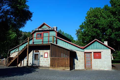
    <summary type="html"><![CDATA[<p><strong><em>In the 19th century, the United States rapidly expanded West. This expansion was expedited by the discovery of gold in the western mountains. Along with it came an influx of Chinese workers. As anti-Chinese sentiment festered during the latter half of the century, a medicine shop rose to prominence in John Day, Oregon.</em></strong></p><img src="https://www.intermountainhistories.org/files/fullsize/5bc7a3df9efef6793d330b545baa0691.jpg" alt="Kam Wah Chung Museum" /><br/><p><span style="font-weight:400;">Along the Dalles Military Road sits the small town of John Day, Oregon. In the mid-1860s, a Chinatown hub for the Chinese miners and immigrants emerged in the area. A small wooden building purchased by Ing Hay and Lung On served as the foundation for a business with—at the time—no promises for future success.</span> <span style="font-weight:400;">Ing Hay was both an herbalist and pulsologist, diagnosing patients based on their pulse. Born in 1862, he sought better fortunes in the Western United States in 1887. In John Day, Oregon, he met Lung On and purchased the dying Kam Wah Chung & Co. Locally known as “Doc” Hay, he treated a variety of ailments with traditional Chinese remedies based on Taoist teachings of harmony and balance. His clientele diversified and included more non-Chinese patients through the 1910s. </p> <span style="font-weight:400;">Lung On, on the other hand, was a savvy businessman fluent in both Chinese and English. He was also a Chinese immigrant and managed the business side of Kam Wah Chung which included pricing, inventory, translating and responding to letters. Locally known as “Leon”, he owned, co-owned, and invested in numerous other operations around Oregon, including businesses, land and mining claims, racehorses, and later an automotive dealership. He also provided a letter-writing service and assistance in navigating American laws for Chinese migrants and immigrants.</p> <span style="font-weight:400;">Together, the two transformed Kam Wah Chung & Co. into a successful mercantile, apothecary, and clinic. It also served as an education and community center. Kam Wah Chung served as an anchor for the surrounding Chinese community and a bridge for non-Chinese neighbors during an era of heightened anti-Chinese sentiment. This success continued into the early 20th century until Lung On’s death in 1940. Ing “Doc” Hay moved to Portland in 1948 due to failing health. The Kam Wah Chung & Co. has been converted into a museum that houses a plethora of Lung On’s untranslated ledgers and documents, Chinese medicinal recipes from Ing Hay’s days of practice, and records of the significant footprint Hay and On left on western U.S. history.</span>
<i><span style="font-weight:400;">Friends Of Kam Wah Chung, </span></i><span style="font-weight:400;">a non-profit organization, continues to research, translate, and excavate the cultural artifacts left behind in John Day. More information about current research and the museum can be found on their website, and much of their work is available to the public. Kam Wah Chung is now a state park and National Historical site.</span></p><p><em><strong><a href="https://www.intermountainhistories.org/items/show/743">For more (including 6 images) view the original article</a></strong></em></p>]]></summary>
    <published>2023-04-10T19:33:02+00:00</published>
    <updated>2026-04-17T19:32:16+00:00</updated>
    <link rel="alternate" type="text/html" href="https://www.intermountainhistories.org/items/show/743"/>
    <id>https://www.intermountainhistories.org/items/show/743</id>
    <author>
      <name>Emma Dutcher, Brigham Young University</name>
    </author>
  </entry>
  <entry>
    <title type="html"><![CDATA[Preserving the WY Medicine Wheel]]></title>
    <summary type="html"><![CDATA[<p><strong><em>For decades, American Indians have fought to preserve sacred sites across the United States.  One important site is the Wyoming Medicine Wheel, located in the Bighorn Mountains, 60 miles outside of Sheridan, Wyoming.</em></strong></p><img src="https://www.intermountainhistories.org/files/fullsize/f55d6614142cdabeb464d673bb1b482d.jpg" alt="Medicine Wheel" /><br/><p>It is not known what group of indigenous peoples built the Wyoming Medicine Wheel, located 60 miles outside of Sheridan, Wyoming in the Bighorn Mountains, or when they did so, but various Native American tribes have used the wheel as a sacred site for centuries. The Medicine Wheel is a circular pattern of stones surrounding a central stone cairn; twenty-eight stone pathways lead to smaller cairns as part of the wheel. Today, a six-foot-high barbed wire fence surrounds the wheel, placed by the Forest Service to protect the Medicine Wheel.
Those indigenous people who consider the wheel a sacred sight view the Medicine Wheel as a holistic model for life. The different teachings of the Medicine Wheel help individuals learn to live in balance with the Creator and all of creation. A 2007 article in the newspaper <em>Win Awenen Nisitotung</em> described how tribes use the Medicine Wheel: “The medicine wheel is like a mirror in which everything about human condition is reflected back.” The Medicine Wheel assists people along their path of life. This sacred site is important to Indigenous people to continue their ceremonies using the Medicine Wheel.
In 1970, the United States Forest Service designated the Medicine Wheel a National Historic Landmark. Tourists took to visiting the wheel, but the National Forest Service did not adequately provide protection for the site. Over the decades, some visitors removed rocks from the Wheel and vandalized the site with graffiti. In the early 1990s, tribes and coalitions fought to protect this land such damages and thefts.
On June 9, 1993, tribes—including the Arapaho, Blackfeet, Cheyenne, Crow, Navajo, Shoshone, Sioux, and Southern Ute—political coalitions, and the Forest Services reached an agreement on managing the site. The Memorandum of Agreement (National Historic Preservation Act) contained several steps to curtail damage caused by tourists. The agreement reads, “The programmatic agreement will require the Forest Service in consultation with the parties to the MOA, to develop and implement a long term management plan which specifies the preservation and continued use of the Medicine Wheel and vicinity as its management priority.” Under the terms of the memorandum, the Forest Service agreed to only open Medicine Wheel to tourists between July 1 and November 1. Visitors would have to park away from the wheel itself and walk one-and-a-half a miles to the site. The government agreed to involve tribal members in discussions about managing the sacred site. The Forest Service would also close the site to visitors for three days around each equinox and solstice to “allow native practitioners undisturbed use for traditional rites and ceremonies.” This agreement set an important precedent. The government acknowledges sacred sites and protects them for American Indians.
Tribes have faced difficulties persuading the Forest Service to follow through with the National Historic Preservation Act. In May 1996, Diana Tillman Mitchell, a report for <em>On Indian Land</em>, revealed how the Forest Service failed to comply with the agreement. They were not including the elders from tribes in their consultations or management requirements. Mitchell wrote, “The guidance and policies should have active participation and notification to all Indian people involved! This is not happening.” The negotiations between Forest Service and the coalitions and tribes continued for a little over twenty years before reaching a final agreement. The updated agreement was implemented in September 1996 which issued the protocols the Forest Service must still follow followed today. The protocols designate 23,000 acres as sacred space to Native American and have provisions allowing Native American practitioners to use the site for ceremonies. In 2011, ethnographic discoveries about indigenous people’s cultural use of the surrounding landscape prompted the Forest Service to extend the boundaries of the Medicine Wheel National Historic Landmark to include an additional 4,080 acres. With this expansion, the Service also changed the name of the landmark to Medicine Mountain.
The steps taken in the 1990s to preserve the Medicine Wheel promoted a working relationship between Indigenous people and the United States government. Tribes and the federal government took steps to protect this special and sacred place. Still, the negotiated nature of this collaboration leaves some, including journalist Diana Tillman Mitchell, concerned that “the economics of a location may always outweigh Indigenous religious freedom.” Advocates like Chris Peters (Pohlik-lah/Karuk), an officer in Seventh Generation Fund, have insisted on their right to preserve sacred lands—“What’s more American: the right to drill for oil or the right to pray?—but when reviewing how the government has interacted with indigenous peoples in the past, it seems that if there is value to the land, the state will take it.</p><p><em><strong><a href="https://www.intermountainhistories.org/items/show/621">For more (including 3 images) view the original article</a></strong></em></p>]]></summary>
    <published>2022-06-25T01:36:18+00:00</published>
    <updated>2026-04-17T19:32:13+00:00</updated>
    <link rel="alternate" type="text/html" href="https://www.intermountainhistories.org/items/show/621"/>
    <id>https://www.intermountainhistories.org/items/show/621</id>
    <author>
      <name>Jessica Donaho, University of Wyoming</name>
    </author>
  </entry>
  <entry>
    <title type="html"><![CDATA[Suffrage at the Salt Lake Tabernacle]]></title>
    <summary type="html"><![CDATA[<p><strong><em>In 1871, national women’s suffrage leaders met at Temple Square in Salt Lake City, Utah, a year after Seraph Young cast the nation’s first vote by a woman under an equal suffrage law. Both Susan B. Anthony and Elizabeth Cady Stanton were present and spoke to the crowd that gathered. </em></strong></p><img src="https://www.intermountainhistories.org/files/fullsize/09accb9bcc5e5a535558ca686a74dbf4.jpg" alt="Tabernacle at Temple Square" /><br/><p>The Church of Jesus Christ of Latter-day Saints (sometimes nicknamed “Mormons”) built the Salt Lake Tabernacle as a space where members could gather in large groups. Its design was such that the acoustics carry a speaker’s voice a long distance, allowing many people to hear. This made the Salt Lake Tabernacle the perfect location for a historic gathering of women’s suffragists, including Susan B. Anthony and Elizabeth Cady Stanton. Susan B. Anthony and Elizabeth Cady Stanton were incredibly prominent suffragists in the nineteenth century. Anthony is the most widely known suffragist of her time and has become a historical icon, having traveled the country to help organize women’s rights organizations, circulate petitions, and give speeches that inspired women, and men as well, to join the movement. Stanton, another leader in the movement, also toured the United States speaking to women about suffrage. In 1871, both Anthony and Stanton visited Utah Territory. For both Anthony and Stanton, traveling to Utah to watch women exercise their right to vote was incredibly significant. They each bore speeches to women assembled at the Salt Lake Tabernacle in Temple Square, expressing the magnanimity of the privilege that they had received, their opposition to young marriages taking place in Utah, and their support for other women’s rights initiatives such as family planning. While in Salt Lake City, Anthony and Stanton also establish the Women’s Suffrage Association of Utah, an affiliate of Susan B. Anthony’s National American Woman Suffrage Association. Today, the Salt Lake Tabernacle is a National Register Historic Landmark District, both because of its significance as a religious site and as a site of women’s suffrage.</p><p><em><strong><a href="https://www.intermountainhistories.org/items/show/616">For more (including 4 images) view the original article</a></strong></em></p>]]></summary>
    <published>2022-06-23T07:30:55+00:00</published>
    <updated>2026-04-17T19:32:13+00:00</updated>
    <link rel="alternate" type="text/html" href="https://www.intermountainhistories.org/items/show/616"/>
    <id>https://www.intermountainhistories.org/items/show/616</id>
    <author>
      <name>Megan Salinas, Northern Arizona University</name>
    </author>
  </entry>
  <entry>
    <title type="html"><![CDATA[Suffrage at Council Hall in Salt Lake City]]></title>
    <summary type="html"><![CDATA[<p><strong><em>In 1869, Utah became the second territory to codify women’s right to vote, and in 1870 a young woman named Seraph Young became the first woman in the United States to cast a vote under an equal suffrage law.</em></strong></p><img src="https://www.intermountainhistories.org/files/fullsize/ec17009c35844913ef31aefc7de55ea3.jpg" alt="The first vote under equal suffrage" /><br/><p>Wyoming became the first United States territory to extend women the right to vote with the passage of an equality act in 1869. A few months later, Utah Territorial Secretary S. A. Mann signed a similar act, extending voting rights to women who were at least twenty-one-years old and were U. S. citizens or the wife, daughter, or widow of a U. S. citizen. Utah then beat Wyoming to the punch when a woman named Seraph Young—a young schoolteacher and grandniece of Brigham Young, former territorial governor and then-president of The Church of Jesus Christ of Latter-day Saints (nicknamed “Mormons”), the majority faith in Utah—made history on February 14, 1870, when she walked up the steps to Utah’s Council Hall in Salt Lake City and became the first woman to legally cast a vote, only a few days after Utah passed the equal suffrage act.
The seeming irony of women first voting in Utah was not lost to history. In the nineteenth century, Utah was nationally famous—or infamous—for the Latter-day Saints’ practice of religious polygamy, something many Americans at the time and later on as well considered irreconcilable with women suffragists’ vision of political rights and social equality. Latter-day Saints plural marriage primarily took the form of polygyny, meaning one man could have multiple wives, and many people believed this practice could only be oppressive to women. However, polygamy was not a hindrance to making Utah one of the earliest sites of women's suffrage. To anti-polygamists, Utah was the perfect place to experiment with women’s voting rights, as they hoped enfranchised women would rise up and end the practice through their votes. Inside Utah, however, it was this exact attitude that drove Utahns to adopt women’s suffrage, hoping that endorsing women’s voting rights would dispel the idea that their society oppressed women.
Although only a few women voted in this first special election in 1870, thousands more joined in by voting in Utah’s general election a few months later. A few years after her momentous vote, Seraph Young married veteran Seth L. Ford, and they later moved to New York City in the late 1870s to be close to his family. Even though Young was a part of such a momentous occasion, she was all but forgotten in popular memory until Utah women and Young’s descendants resurrected her story in the twenty-first century. In February 2020, Utah women gathered to march from City Creek Park to Council Hall, honoring Young and the other women who were so important to Utah’s history. A mural displayed at Council Hall also commemorates Young’s historic vote.</p><p><em><strong><a href="https://www.intermountainhistories.org/items/show/615">For more (including 4 images) view the original article</a></strong></em></p>]]></summary>
    <published>2022-06-23T06:04:16+00:00</published>
    <updated>2026-04-17T19:32:13+00:00</updated>
    <link rel="alternate" type="text/html" href="https://www.intermountainhistories.org/items/show/615"/>
    <id>https://www.intermountainhistories.org/items/show/615</id>
    <author>
      <name>Megan Salinas, Northern Arizona University</name>
    </author>
  </entry>
  <entry>
    <title type="html"><![CDATA[Suffrage in South Pass City]]></title>
    <summary type="html"><![CDATA[<p><strong><em>South Pass City, Wyoming, has long been considered “the birthplace of the women’s suffrage movement” in the West. It is here that women first secured a codified right to vote, and it was also home to the first woman Justice of the Peace. </em></strong></p><img src="https://www.intermountainhistories.org/files/fullsize/b97ab37a1b561f9bed835ce7511cda5a.jpg" alt="City of suffrage" /><br/><p>South Pass City, Wyoming, was the site of Wyoming’s first gold boom. In 1867, prospectors discovered gold, and soon a thousand people rushed to the area, hoping to strike it rich. Like most other gold strike towns, South Pass City boomed and then busted, and most of the newcomers abandoned the community by 1872. However, during the rush, South Pass City became one of the major sites of women’s suffrage in the United States, and is known by some as the birthplace of the women’s suffrage movement.
In 1869, during Wyoming’s first territorial legislation, a saloon keeper named William Bright presented a bill to recognize and affirm women’s right to vote in the territory. The governor at that time, Otis Campbell, passed this bill in December of the same year. This, for the first time, gave women not only the right to vote in Wyoming but to also hold office. In February of 1870, only a few months after the passing of the bill, residents elected South Pass City resident Esther Hobart Morris as Justice of the Peace. She was the first woman in the United States to hold judicial office.
Because of South Pass City’s role in women’s suffrage, the National Park Service designated it a National Historic Landmark in 1961, and the Wyoming 75th Anniversary Commission purchased the town for the state citizens as a “birthday present” in 1966. Four year later, the town was added to the National Register of Historic Places and still operates today as a state park. In 2019, the Wyoming legislature passed a joint resolution recognizing December 10, 2019, as Wyoming Women’s Suffrage Day, commemorating the 150th anniversary of the passage of the bill formally enabling women to vote. </p><p><em><strong><a href="https://www.intermountainhistories.org/items/show/614">For more (including 4 images) view the original article</a></strong></em></p>]]></summary>
    <published>2022-06-23T04:53:03+00:00</published>
    <updated>2026-04-17T19:32:13+00:00</updated>
    <link rel="alternate" type="text/html" href="https://www.intermountainhistories.org/items/show/614"/>
    <id>https://www.intermountainhistories.org/items/show/614</id>
    <author>
      <name>Megan Salinas, Northern Arizona University</name>
    </author>
  </entry>
  <entry>
    <title type="html"><![CDATA[Big Horn Medicine Wheel]]></title>
    <summary type="html"><![CDATA[<p><strong><em>In a picturesque and seemingly significant location, the Big Horn Medicine Wheel may reveal indigenous knowledge of astronomy.</em></strong></p><img src="https://www.intermountainhistories.org/files/fullsize/e3c611b4ff4e6359f87c4c7f5dede281.jpg" alt="Big Horn Medicine Wheel" /><br/><p>At the top of the Big Horn Mountains, 9,642 feet above sea level, on the west ridge of Medicine Mountain, lies the Big Horn Medicine Wheel. The wheel sits about twenty yards away from a limestone cliff face, where visitors can look down upon the Big Horn Basin, the Wind River, and the Pryor Mountains of Montana. Using a piece of wood found built into the structure, archaeologists dated the Medicine Wheel itself to around 1760 AD. Other archaeological research carbon-dated charcoal and wood fragments found near the Medicine Wheel to 4,529 BCE.
The wheel is made of hundreds of white limestone rocks arranged in roughly in the circular shape of a wheel. Spanning eighty feet in diameter, the wheel is a true marvel, as most rocks used as material for the massive wheel originate from the bottom of the mountain, meaning the builders carried them to the top. At the center of the wheel lies another smaller circle, and 28 “spokes” radiate from this smaller center circle, connecting the center to the perimeter of the wheel. Small hollow cairns surround the wheel.
Although much research has been done on the wheel, archaeologists, astronomers, and other scholars have been unable to determine its origin and function. One astronomer suggests the indigenous builders might have designed the wheel to track celestial bodies, having found the cairns are in astronomical alignment with the summer solstice sunset and sunrise as well as the rise of the stars Alderbaran, Serius, and Rigel. Another astronomer disagrees, saying that had the medicine wheel’s purpose been to track the solstice and stars, the structure’s design would have been more precise and astronomical alignments with the wheel would be more obvious and practical. An archaeologist suggests that the cairns could have been small shelters for vision quest participants while another archaeologist believes the wheel is a model of a Cheyenne medicine lodge. A Crow legend tells the story of a boy that was able to find healing and tribal acceptance through the power connected to the wheel. The Cheyenne believe that the Legend of Sweet Medicine inspired the Big Horn Medicine Wheel. Many theories have been proposed and disputed, but no theory has provided irrefutable evidence for a single explanation.
The Big Horn Medicine Wheel is a national historical landmark and is still used by tribes for religious purposes. Visitors are allowed to view the Big Horn Medicine Wheel but are asked to respect the ancient site as it holds both religious and historical significance to many Native Americans.</p><p><em><strong><a href="https://www.intermountainhistories.org/items/show/582">For more (including 5 images) view the original article</a></strong></em></p>]]></summary>
    <published>2022-03-19T10:04:39+00:00</published>
    <updated>2026-04-17T19:32:12+00:00</updated>
    <link rel="alternate" type="text/html" href="https://www.intermountainhistories.org/items/show/582"/>
    <id>https://www.intermountainhistories.org/items/show/582</id>
    <author>
      <name>Kelli Holiday, Brigham Young University</name>
    </author>
  </entry>
  <entry>
    <title type="html"><![CDATA[Canyon Lodge at Yellowstone National Park]]></title>
    <summary type="html"><![CDATA[<p><strong><em>The historic Canyon Lodge hosts a variety of dining options, indoor and outdoor areas for eating and resting, and a gift shop. It was the first Mission 66 project in the nation and exemplifies form and function in architecture.</em></strong></p><img src="https://www.intermountainhistories.org/files/fullsize/5b51b784f3f902f9b9f18b001c535c11.jpg" alt="Lounge rendering" /><br/><p>Established in 1872, Yellowstone National Park had been selected by the Park Service to be the inaugural project for Mission 66 since it was the first national park. Like most national parks, planning for new building projects started well before the introduction of Mission 66 in the 1950s but received funding when the Eisenhower administration approved the ten-year program which aimed at upgrading park infrastructure in response to the post-World War II visitor boom. In February 1956, the Park Service signed a contract with the Architectural firm Welton Becket & Associates from California; by June, the park broke ground for Canyon Village. Due to the severity of Yellowstone National Park winters, planning and construction periods were narrow. Part of the construction plans included 300 cabins that would be used as motel rooms. Due to a $1 million budget mistake, Welton Becket & Associates and the Park Service increased the number of cabins to 512 to try to create more revenue for the park and recover from the budget fault.
The dedication ceremony of the Canyon Visitor Center took place in August 1957, and the Canyon Lodge opened shortly after. After opening, the Canyon Visitor center operated until 2006 when it closed for renovations. The Park Service had the cabins demolished in 2013 to make room for a modern hotel. 
The original Canyon Village Lodge featured a mid-century modern architectural style adapted to the natural surroundings of Yellowstone National Park. Little of the original Canyon Lodge remains today. To accommodate for an increase in visitors, renovators relocated restrooms outside, allowing more space inside for seating and visitor traffic throughout the building. The original structure had been constructed with stone, concrete, wood, and glass. Xanterra Parks and Resorts renovators relocated a bar in the dining area in 1964 and covered the wooden floors with carpet in 1985. Translucent walls were replaced by concrete, and all the original furnishings have been removed, except for one couch. Original features including fireplaces and wooden mantels have survived the renovations and add a touch of history to the interior of the space. The glass walls have remained unaltered as well. On the exterior, new roofing plans have been in the works to add flat roofs, but the architects are concerned about snowfall buildup causing a collapse. For now, the pitched roofs remain. The Yellowstone National Park Canyon Village Lodge still serves as one of the main stops in the park for visitors to relax and find a bite to eat.</p><p><em><strong><a href="https://www.intermountainhistories.org/items/show/518">For more (including 3 images) view the original article</a></strong></em></p>]]></summary>
    <published>2021-10-15T09:59:27+00:00</published>
    <updated>2026-04-17T19:32:11+00:00</updated>
    <link rel="alternate" type="text/html" href="https://www.intermountainhistories.org/items/show/518"/>
    <id>https://www.intermountainhistories.org/items/show/518</id>
    <author>
      <name>Jennifer John, Northern Arizona University</name>
    </author>
  </entry>
  <entry>
    <title type="html"><![CDATA[Elinore Pruitt Stewart, Female Homesteader<br />
]]></title>
    <summary type="html"><![CDATA[<p><strong><em>“I just love to experiment, to work, and to prove out things,” wrote Elinore Pruitt Stewart in 1913. “Ranch life and ‘roughing it’ just suit me.” Elinore was not born into homesteading, but it suited her and she sought it out in her search for independence.</em></strong></p><img src="https://www.intermountainhistories.org/files/fullsize/8531e6b6c25202a7b1390570da791f74.jpg" alt="Front of the Stewart Cabin
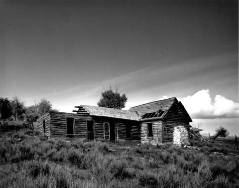
" /><br/><p>Orphaned in her teenage years, Elinore Pruitt Stewart was accustomed to independence. She found employment as a housekeeper for Mrs. Juliet Coney in Colorado after leaving a failed marriage in Oklahoma. In 1909, Elinore decided to seek a more permanent and reliable life for herself and her daughter, Jerrine. Following the advice of her employer and her priest, Elinore began looking for a position as a housekeeper for a homesteader. She accepted a position from Clyde Stewart and moved west to his property in Burntfork, Wyoming.</p><p>That May, she filed for a 160 acre homestead under the Homestead Act on a lot adjacent to Clyde’s. The two married shortly after. She recalled that first summer of work as “the busiest, happiest” she could remember. While the work was hard, it was labor she could “really enjoy.” Over the years, Elinore detailed her life and experiences in Wyoming in letters sent to her friend and previous employer, Mrs. Coney. This collection of letters was later published as a book. It heralded the merits of homesteading as a means for women to provide for themselves. Of women considering the possibility, Elinore wrote, “I feel like urging them every one to get out and file on land… It really requires less strength and labor to raise plenty to satisfy a large family than it does to go out to wash, with the added satisfaction of knowing that their job will not be lost to them if they care to keep it.” She was “very enthusiastic about women homesteading” as a source of autonomy and solution to poverty. In her eagerness for independence and ownership of land, Elinore delayed revealing her new husband to Mrs. Coney until nearly a year after the marriage took place. </p><p>Homestead law required that married women file jointly with their husbands or live separately. Elinore had to relinquish her claim to her mother-in-law in 1912 to avoid losing it completely. She and Clyde later bought the property back once the deed had been acquired. Together they had five children, three of whom survived to adulthood. The family wintered in Boulder, Colorado so their children could attend school there. The remaining months were spent on the ranch, gardening, haying, and caring for livestock. </p><p>In addition to the hard labor, Elinore’s letters described trips with her children or into the mountains. On one such occasion, “after working so hard and so steadily,” she got away by dawn and had a “glorious day” riding in the hills with Jerrine. The publication of her letters brought some notoriety and time was also spent entertaining visitors who came to meet the confident and optimistic woman homesteader.</p><p>Elinore spent her life working and improving the Stewart homestead until her death in 1933. She died of a blood clot to the brain after a surgery following several bouts of serious illness in the years leading to her death. She was buried in Burntfork Pioneer Cemetery, leaving both a historic and a literary legacy that preserves her memory as a successful female homesteader in the American West. </p><p>The ranch continued to be operated by Clyde and their sons until it was leased in 1940 and then sold. The site is now included on the National Register of Historic Places. The homestead building still remains at its original site, although in a much dilapidated condition. There are no current plans to preserve or restore it.</p><p><em><strong><a href="https://www.intermountainhistories.org/items/show/457">For more (including 4 images) view the original article</a></strong></em></p>]]></summary>
    <published>2021-02-07T05:41:39+00:00</published>
    <updated>2026-04-17T19:32:09+00:00</updated>
    <link rel="alternate" type="text/html" href="https://www.intermountainhistories.org/items/show/457"/>
    <id>https://www.intermountainhistories.org/items/show/457</id>
    <author>
      <name>Anna Bailey, Brigham Young University</name>
    </author>
  </entry>
  <entry>
    <title type="html"><![CDATA[The Kuaua Pueblo Ruins and the Coronado Historic Site]]></title>
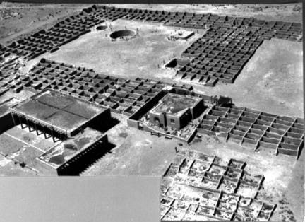
    <summary type="html"><![CDATA[<p><strong><em>During Francisco Vasquez de Coronado’s expedition to New Mexico in the 1540s, he came into contact with the Tiwa people who lived in pueblos near modern-day Albuquerque. In the 1930s, archaeologists excavated the ruins of Kuaua, one of the largest pueblos. These ruins currently constitute a large part of the Coronado Historic Site.</em></strong></p><img src="https://www.intermountainhistories.org/files/fullsize/abc8c5fc50ca9f4f5d8bae95e244cdb1.jpg" alt="Kuaua ruins, Coronado State Monument, 1940" /><br/><p>Archaeologists located the Kuaua Pueblo ruins just north of Albuquerque, New Mexico along the banks of the Rio Grande River. Created as part of the 400th anniversary of Francisco Vasquez de Coronado’s entry into New Mexico, the Coronado History Site references the expedition’s interactions with local Tiwa villages. Kuaua, a name meaning “evergreen” in Tiwa, was one of the largest of these villages and may have been the site of Coronado’s winter headquarters during the expedition. Archaeologists have estimated that the Tiwa settled this village in the fourteenth century and likely contained more than one thousand people when they came into contact with Coronado. However, conflict over the years with Coronado and other Spanish explorers eventually led to the Tiwa’s abandonment of Kuaua Pueblo in the sixteenth century.</p><p>When the archaeological team excavated the Kuaua Ruins in the 1930s, they uncovered more than 1,200 adobe rooms, three ceremonial rooms, and six kivas. Several of the kivas contained a series of murals that many revere today as some of the best examples of Pre-Columbian artwork in the United States. Kuaua religious murals flourished throughout the fourteenth, fifteenth, and sixteenth centuries, reflecting religious and cosmological iconography such as references to rain, rainbows, clouds, lightning, and ritual figures engaging in rain-making rituals. These rituals formed an important part of Pueblo culture and religion due to the region’s general climate of minimal precipitation. </p><p>Thanks to extensive conservation efforts since the 1930s, the murals have been preserved for modern viewing. The Coronado Historic Site includes a Visitor Center, which features fourteen examples of original mural artwork as well as Pueblo Indian and colonial Spanish artifacts. Several trails throughout the ruins of the pueblo and along the Rio Grande River provide exploration opportunities for visitors wishing to more authentically learn about the Tiwa Pueblo culture and lifestyle.</p><p><em><strong><a href="https://www.intermountainhistories.org/items/show/404">For more (including 3 images) view the original article</a></strong></em></p>]]></summary>
    <published>2020-03-11T22:43:42+00:00</published>
    <updated>2026-04-17T19:32:08+00:00</updated>
    <link rel="alternate" type="text/html" href="https://www.intermountainhistories.org/items/show/404"/>
    <id>https://www.intermountainhistories.org/items/show/404</id>
    <author>
      <name>Sarah Rounsville, Brigham Young University</name>
    </author>
  </entry>
</feed>