<?xml version="1.0" encoding="UTF-8"?>
<feed xmlns="http://www.w3.org/2005/Atom">
  <title type="text">Intermountain Histories</title>
  <updated>2026-04-17T19:32:19+00:00</updated>
  <generator uri="http://framework.zend.com" version="1.12.20">Zend_Feed_Writer</generator>
  <link rel="alternate" type="text/html" href="https://www.intermountainhistories.org/"/>
  <link rel="self" type="application/atom+xml" href="https://www.intermountainhistories.org/items/browse?output=rss2"/>
  <id>https://www.intermountainhistories.org/</id>
  <author>
    <name>Intermountain Histories</name>
    <uri>https://www.intermountainhistories.org</uri>
  </author>
  <link rel="hub" href="https://pubsubhubbub.appspot.com/"/>
  <entry>
    <title type="html"><![CDATA[Dowa Yalanne Mountain]]></title>
    <summary type="html"><![CDATA[<p><strong><em>Many notable events for the Zuni people transpired on Dowa Yalanne, including traditional legends and ceremonies. It provided the Zunis protection against the invading Spanish and other raiding groups and continues to inspire and remind the Zuni people of their culture and history.</em></strong></p><img src="https://www.intermountainhistories.org/files/fullsize/ae143c3a012b84adff08586fd045f838.jpg" alt="“Dowa Yalanne Mountain.”" /><br/><p>Located in New Mexico on the Zuni reservation, Dowa Yalanne, or Corn Mountain, overlooks Zuni Pueblo at an elevation ranging in the 7000s. A Zuni legend explains that during an intense flood, the people fled to the top of the Dowa Yalanne, bringing their corn. To cause the water to recede, they sent a son and daughter of a Zuni priest into the water as an offering. Eventually the waters receded, revealing that the son and daughter turned to stone. Corn Mountain’s mesa features approximately 320 acres of Zuni sandstone, mudstone, and Dakota sandstone. Based on these sedimentary rocks, Dowa Yalanne appears to have formed during the Triassic and Jurassic periods and is recognizable by its red and white coloring. Piñon-juniper trees populate the mountain, along with smaller brush and foliage. </p><p>During the early days of European contact, Dowa Yalanne offered the Zuni people refuge from the Spanish conquistadors. In 1540, after Francisco Vasquez Coronado and his men battled at the Zuni village of Hawikuh, the remaining Zunis fled to Corn Mountain to escape Spanish occupation. Familiar with the mountain trails, they remained secluded until the Spanish left. The Zuni then returned to their villages once it appeared safe. </p><p>Zunis utilized Dowa Yalanne as a place of retreat before contact with the Spanish when conflict arose with other tribes. Zunis returned to Dowa Yalanne in 1632 after they conspired and killed two Franciscan Friars and Spanish soldiers stationed at Hawikuh. It was not until 1635 that the people of the six Zuni villages entirely left the mountain’s protection. This particular cycle continued in 1680, after the immediate events of the Pueblo Revolt, and again in 1703 when the Zunis repulsed Spanish interlopers.  From that point on, the use of Dowa Yalanne as a place of protection significantly diminished due to fewer conflicts.</p><p>Zuni rock art decorates Dowa Yalanne in locations where they took refuge. The historic engraved shields and mountain lion iconography served a magical protective function for them. Zunis still maintain sacred shrines on the top of Dowa Yalanne mesa, cementing its spiritual reminder of Zuni culture and resilience during difficult circumstances.</p><p><em><strong><a href="https://www.intermountainhistories.org/items/show/849">For more (including 4 images) view the original article</a></strong></em></p>]]></summary>
    <published>2024-09-24T18:01:38+00:00</published>
    <updated>2026-04-17T19:32:19+00:00</updated>
    <link rel="alternate" type="text/html" href="https://www.intermountainhistories.org/items/show/849"/>
    <id>https://www.intermountainhistories.org/items/show/849</id>
    <author>
      <name>Joseph Namingha, Brigham Young University</name>
    </author>
  </entry>
  <entry>
    <title type="html"><![CDATA[“Purple Mountain Majesties”: Why Pikes Peak is America’s Mountain]]></title>
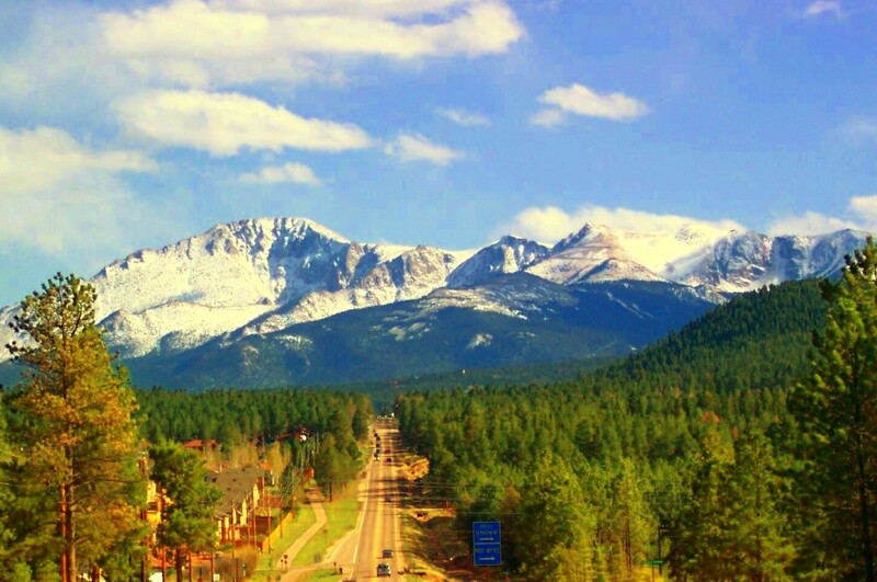
    <summary type="html"><![CDATA[<p><strong><em>Pikes Peak has a long and valuable history that provides visitors with a look through different ages of America, highlighting the beauty and diversity of the land and people. </em></strong></p><img src="https://www.intermountainhistories.org/files/fullsize/fabf35ca83b85ec7549a243f9e4cbd07.jpg" alt="Pikes Peak" /><br/><p><span style="font-weight:400;">With incredible height, diversity, age, and beauty, Pikes Peak towers above at an astounding 14,115 feet, making it one of the tallest mountains in the United States. Many, if not all, Americans have heard the moving lyrics to “America the Beautiful,” but few know that Pikes Peak was the inspiration for the song. Pikes Peak has long been the subject of ballads of beauty and adventure, as well as a symbol of hope and freedom for many throughout American history. </span>
<span style="font-weight:400;">The peak itself has undergone a variety of “discoveries” throughout the different ages of settlement. Some of the first people believed to have discovered and lived near Pikes Peak were the Clovis people yet not much is known or recorded of their experience. However, the histories of many Native peoples’ lifestyles, religions, and legends centered around the peak. The Utes, or the Tabeguache, believed the mountain itself was a sacred site where the Great Spirit created the earth and where many ceremonies were held. </span>
<span style="font-weight:400;">The Spanish were the first Europeans to discover the peak in 1779 and named it “El Capitán,” or “The Captain,” due to the imposing nature of the peak. With the completion of the Louisiana Purchase, the French sold vast tracts of land to the United States of America. In an effort to appraise the land and resources the United States had obtained, President Jefferson sent out several different expeditions to explore and record the areas. It was not until 1806 that Zebulon Pike, the first American explorer who dubbed the mountain Pike’s Peak, came to the Colorado area and attempted to hike the peak. The expedition failed to summit it because they were not prepared for the weather, and the peak remained an alluring call for explorers to attempt to conquer. </span>
<span style="font-weight:400;">Pikes’ writing on his expedition, including the details about the imposing mountain, were published in several languages and widely distributed due to their fame and the public’s interest in the unexplored West. In his writings, Pike referred to the peak as the “the Grand Peak” or simply, “highest peak.”  In 1820, Dr. Edwin James made the first recorded ascent. Later in its history, a variety of media featuring Pikes Peak attracted settlers and spurred further western migration. The phenomenon started with miners and spectators with the discovery of gold and gradually drew more settlers with large plots of grazing land and a tourism industry. Pikes Peak influenced the early formation of American identity and still manages to inspire those who visit today.</span></p><p><em><strong><a href="https://www.intermountainhistories.org/items/show/747">For more (including 5 images) view the original article</a></strong></em></p>]]></summary>
    <published>2023-04-11T18:29:54+00:00</published>
    <updated>2026-04-17T19:32:16+00:00</updated>
    <link rel="alternate" type="text/html" href="https://www.intermountainhistories.org/items/show/747"/>
    <id>https://www.intermountainhistories.org/items/show/747</id>
    <author>
      <name>Addie Coombs, Brigham Young University</name>
    </author>
  </entry>
  <entry>
    <title type="html"><![CDATA[Oro City: The Beginnings of Leadville]]></title>
    <summary type="html"><![CDATA[<p><strong><em>A once prosperous mining town, Oro City is not just a ghost town left behind by the Colorado gold rush. It is also an environmental hazard.</em></strong></p><img src="https://www.intermountainhistories.org/files/fullsize/128ef543b5fc00e04b72795a7bffb3a1.jpg" alt="Hydraulic mining in California Gulch" /><br/><p><span style="font-weight:400;">In early 1860, prospectors were exploring gulches and panning for gold deep in the Rocky Mountains of Colorado. One prospector, Abe Lee, produced the lucky pan with gold in late April. They named the area California Gulch, supposedly because Abe Lee exclaimed, “I’ve just got California in this here pan!” By summer of the same year, California Gulch’s population had risen from the original party of miners to five thousand individuals, including women. California Gulch was seven miles long and a city grew around it, eventually concentrated toward the northern end of the Gulch. This town came to be known as Oro City and served as the precursor to the modern-day city of Leadville.</span>
<span style="font-weight:400;">Oro City experienced waves of growth and decline as the seasons changed and as gold waned and silver and ore increased. In the beginning, the city had no official government and instead operated using the miners’ code and group meetings.  When Colorado became a territory the next year, Oro City became the county seat of Lake County and elections were held. The city’s population fluctuated seasonally, as winter conditions made mining difficult or impossible. Annual spring thaws repeatedly brought miners back until around 1865. By that point around five million dollars of gold had been extracted from three miles of the gulch, but gold-producing ore was exhausted. The population began to decline thereafter. A stamp mill named “The Printer Boy” was constructed in 1868 and helped partially sustain the local economy, but diminishing ore and continued technological troubles with requisite water pumping hindered business. The Printer Boy soon closed, along with other mills and smelters, and Oro City’s population moved elsewhere.</span>
<span style="font-weight:400;">In 1873 or 1874, a new settlement emerged near Oro City named Slabtown. Slabtown </span><span style="font-weight:400;">later became Leadville when William H. Stevens and Albinus B. Wood began the “Oro Mining Ditch and Fluming Company.” Stevens and Wood bought up large areas in the California Gulch and began producing silver and lead. Mining became concentrated in the Gulch, and the population moved down the mountain.</span>
<span style="font-weight:400;">Today, California Gulch is one of over 200 superfund sites in the state of Colorado, sites the EPA has specifically set aside for environmental recovery. For the most part, the 18 square miles of the superfund site is under control, although young children and expecting mothers should monitor their blood for heavy metals. Although the exposure is under control, the EPA will need to finish construction to seal up mines to create an area that is safe for the public to enter.</span></p><p><em><strong><a href="https://www.intermountainhistories.org/items/show/475">For more (including 3 images) view the original article</a></strong></em></p>]]></summary>
    <published>2021-09-10T23:09:03+00:00</published>
    <updated>2026-04-17T19:32:10+00:00</updated>
    <link rel="alternate" type="text/html" href="https://www.intermountainhistories.org/items/show/475"/>
    <id>https://www.intermountainhistories.org/items/show/475</id>
    <author>
      <name>Nikki Smith, Brigham Young University</name>
    </author>
  </entry>
  <entry>
    <title type="html"><![CDATA[Moose Mine]]></title>
    <summary type="html"><![CDATA[<p><strong><em>The 1868 discovery of silver on Mount Bross started a silver boom in the Mosquito Range in central Colorado. The Moose Mine, known for being incredibly rich, was the leader in this silver boom and contributed to populating central Colorado.</em></strong></p><img src="https://www.intermountainhistories.org/files/fullsize/bdbe4f651328af248f15caf53a4cfbda.jpg" alt="East of Mount Bross" /><br/><p><span style="font-weight:400;">In 1868, Daniel Plummer and Joseph H. Meyers located an outcrop of silver in the central Colorado Mosquito Range of the Rocky Mountains, within limestone on Mount Bross. They named it “The Dwight” Three years later, they returned to Mount Bross and discovered a new outcropping that would come to be known as “the Moose”. This discovery led to a silver boom in the local towns of Alma and Fairplay and set the stage for the later Leadville boom. However, the discovery of silver at 13,600 feet with surrounding 14,000-foot peaks presented challenges. With the highest altitude mines in North America, the Moose Mine region demonstrates the unique difficulties of many high-altitude mines.</span>
<span style="font-weight:400;">Daniel Plummer and Joseph H. Meyers were both previously-experienced miners and had been in Park County, Colorado since the early to mid 1860s. They filed their first claim, “The Dwight,” on March 9, 1869. However, like other rich but remote mines of the time, not much was done to begin mining until after the discovery of the Moose. The first news of the rich discovery in the Moose hit the </span><i><span style="font-weight:400;">Denver Tribune </span></i><span style="font-weight:400;">in late July 1871, and by the end of August Plummer and Meyers had secured Judson H. Dudley and Andrew W. Gill as partners, who provided funding necessary for beginning mining. Simple mining began that year, and by November, ore from the mine was shipping from Leadville to Denver where it would go on to New York City and then its final destination in Wales. This had to be done, especially in the beginning, due to the lack of other smelters in the area who could work with the metal. The closest smelter was located in Black Hawk, and shipping there would have required traveling down to Denver and then back up into the mountains. Traveling there involved a series of high altitude passes that made this option difficult, timely, and expensive. </span>
<span style="font-weight:400;">On April 15, 1872, the Moose Mining Company was formed. In order to accommodate those working at the mines on Mount Bross, Mount Democrat, and Mount Lincoln, the town of Quartzville developed on the east side of Mount Lincoln at 11,300 feet. It was located 2,400 feet below the Moose and was the closest residence to the mines. Miners had to hike over two miles one way to reach the Moose and at such high elevation, individuals only processed around one-third of the oxygen they would be accustomed to at sea level. The combination of less oxygen and their difficult morning hike meant that the miners struggled to be effective. But despite these impediments to labor, in July 1872 the Moose Mine Company averaged $22,500 per week, and the Fairplay </span><i><span style="font-weight:400;">Mount Lincoln Sentinel </span></i><span style="font-weight:400;">claimed that the Moose had produced $330,00 worth of ore in a four-month period. </span>
<span style="font-weight:400;">Today, the Moose Mine remains on private land. Individuals wanting to visit the area can summit four adjacent fourteeners, Mounts Democrat, Cameron, Lincoln, and Bross, via the 8-mile Decalibron (a portmanteau of the four peak names) loop route. Access to the mountains has been limited over the years due to concern about old mining sites and issues with hikers not remaining on trail. Since 2010, hikers have been able to access the peaks within the Decalibron loop but not the mining sites themselves.</span></p><p><em><strong><a href="https://www.intermountainhistories.org/items/show/474">For more (including 3 images) view the original article</a></strong></em></p>]]></summary>
    <published>2021-09-10T21:29:34+00:00</published>
    <updated>2026-04-17T19:32:10+00:00</updated>
    <link rel="alternate" type="text/html" href="https://www.intermountainhistories.org/items/show/474"/>
    <id>https://www.intermountainhistories.org/items/show/474</id>
    <author>
      <name>Nikki Smith, Brigham Young University</name>
    </author>
  </entry>
  <entry>
    <title type="html"><![CDATA[Mount Evans Scenic Byway]]></title>
    <summary type="html"><![CDATA[<p><strong><em>Mount Evans Scenic Byway takes visitors up the highest paved road in North America while also providing an accessible method to “bag” a 14,000-foot peak.</em></strong></p><img src="https://www.intermountainhistories.org/files/fullsize/b806163671458a4258913af20f162046.jpg" alt="Evans Byway" /><br/><p><span style="font-weight:400;">On July 22, 1923, work started on the highest road in North America: the Mount Evans Scenic Byway. Today, visitors can travel its twenty-eight mile stretch one way to reach the summit of the 14,130-foot mountain. The byway begins about sixty miles west of Denver in the mining town of Idaho Springs. Along the way up, visitors pass Echo Lake, Summit Lake, and the Walter Pesman Alpine Garden, which is home to 1,700-year-old bristlecone pines. Along the road, individuals gain 7,000 feet of elevation while those starting in Denver will gain about 9,000 feet. Due to volatile winter conditions, the road is generally only open from Memorial Day to Labor Day. </span>
<span style="font-weight:400;">The first recorded summiting of Mount Evans itself was by landscape painter Albert Bierstadt in 1863. Originally, the mountain was named Mount Rosalie. After the expulsion of Governor John Evans due to the Sand Creek Massacre, the name of the mountain was changed to remember the disgraced governor. The mountain later became more accessible in 1931 when construction of the road was complete and was opened to the public. </span>
<span style="font-weight:400;">Bagging “fourteeners”—a colloquialism meaning summiting a peak 14,000 feet above sea level—is a popular sport in Colorado, and the mountains are hard to resist. Because Mount Evans Scenic Byway is so easy to access, it makes for an easy first peak. After parking at the top of the mountain, individuals only have to hike a quarter of a mile to the real summit. However, high altitude presents many dangers such as oxygen deprivation, extreme sun exposure, and sudden thunderstorms. Visitors may experience altitude sickness, which can be broken down into acute mountain sickness, high-altitude pulmonary edema, and high-altitude cerebral edema. In its less serious stage, acute mountain sickness, individuals may suffer from headaches, nausea, dizziness, and other systems. High-altitude pulmonary edema (HAPE) becomes a possible concern among 15% of healthy individuals at 14,000 feet but is still not the most dangerous form of altitude sickness. Individuals suffering from HAPE may experience confusions, serious fatigue, and coughing or chest tightness. Finally, high-altitude cerebral edema is the most dangerous form of altitude sickness and if not treated, can lead to coma and death. Its symptoms include confusion, incoordination, and even hallucinations, caused by a buildup of fluids in the brain and sometimes lungs. </span>
<span style="font-weight:400;">In order to prevent altitude sickness, individuals are advised to acclimate to altitude gradually, drink plenty of water, and travel high but sleep low. Sunscreen will also help protect individuals against the sun at 14,000 feet, where the atmosphere provides 50% less protection than visitors may be used to. Also, individuals should try to be off the mountain by the afternoon to avoid thunderstorms. All of these steps can help to prevent disaster on the mountain.</span></p><p><em><strong><a href="https://www.intermountainhistories.org/items/show/473">For more (including 4 images) view the original article</a></strong></em></p>]]></summary>
    <published>2021-09-10T09:17:57+00:00</published>
    <updated>2026-04-17T19:32:10+00:00</updated>
    <link rel="alternate" type="text/html" href="https://www.intermountainhistories.org/items/show/473"/>
    <id>https://www.intermountainhistories.org/items/show/473</id>
    <author>
      <name>Nikki Smith, Brigham Young University</name>
    </author>
  </entry>
  <entry>
    <title type="html"><![CDATA[Goat Haunt Ranger Station: Waterton–Glacier International Peace Park]]></title>
    <summary type="html"><![CDATA[<p><strong><em>The Goat Haunt Ranger Station is both a bridge between the Glacier and Waterton National Parks and the northern terminus of the 3,000-mile-long Continental Divide Trail.</em></strong></p><img src="https://www.intermountainhistories.org/files/fullsize/ab2c1a108b32fdcc805dbd19ddbad615.jpg" alt="Goat Haunt Ranger Station" /><br/><p><span style="font-weight:400;">In 1978, the Continental Divide Trail (CDT) was added as one of America’s scenic long-distance trails. It, the Pacific Crest Trail, and the Appalachian Trail are the three most prominent national scenic trails. The CDT’s roughly 3,000 miles of trail are open to day hikers, backpackers, and thru-hikers, with unique sections also open to equestrian use. Anywhere from 150 to 200 hikers attempt the full distance each year but only a third will complete the full distance. To officially count as a thru-hike of the CDT, the hiker must stay within 100 miles of the Continental Divide itself. This is complicated by the fact that only 85% of the trail is officially completed and marked. In order to finish their hike within the five to six months of good weather, hikers need to average about 22 to 25 miles a day. This aggressive pace requires consistently consuming about 6,000 calories each day. </span>
<span style="font-weight:400;">The CDT started as the Blue Can Trail, named for the painted tuna cans used by the Colorado Mountain Club to mark the trail in 1964. The first individual to hike the Continental Divide is disputed, although there is documented evidence through journals and photographs that it may have been by Peter Parsons in 1924. The trail was first proposed to the National Park Service in the 1960s, but it did not become official until 1978. Still, individuals explored the Continental Divide in the years in between. In 1972, Erik Ryback became the first individual to complete the “Triple Crown” of the Appalachian Trail, the Pacific Crest Trail, and the Continental Divide Trail. </span>
<span style="font-weight:400;">Waterton Lake serves as the Northern Terminus for the CDT and marks either the end or the beginning of a thru-hike between the U.S.–Mexico and U.S.–Canada borders. Approximately 20% of CDT thru-hikers begin there as “South Bounders,” and 80% end there as “North Bounders,” all passing through the Goat Haunt Ranger Station located just above Waterton Lake and the international border. The Ranger Station works as a customs station to allow hikers to pass between the two countries and also showcases the international agreement that combined Glacier National Park in the United States with Waterton National Park in Canada to become the first International Peace Park. Ultimately, the Goat Haunt Ranger Station represents both international peace and the start or end of an incredible adventure along the Continental Divide. Those finishing their thru-hikes there will have crossed five states, three national parks, seven different ecoregions, and fourteen native tribal land regions.</span></p><p><em><strong><a href="https://www.intermountainhistories.org/items/show/471">For more (including 3 images) view the original article</a></strong></em></p>]]></summary>
    <published>2021-09-10T08:25:03+00:00</published>
    <updated>2026-04-17T19:32:09+00:00</updated>
    <link rel="alternate" type="text/html" href="https://www.intermountainhistories.org/items/show/471"/>
    <id>https://www.intermountainhistories.org/items/show/471</id>
    <author>
      <name>Nikki Smith, Brigham Young University</name>
    </author>
  </entry>
  <entry>
    <title type="html"><![CDATA[Echo Lake Park]]></title>
    <summary type="html"><![CDATA[<p><strong><em>Primarily known for its recreational sites, Echo Lake Park is not only a historic physics site but also the home of a WWII high altitude training center.</em></strong></p><img src="https://www.intermountainhistories.org/files/fullsize/40a2c39dbbb737d60610ca0405e87236.jpg" alt="Echo Lake" /><br/><p><span style="font-weight:400;">Echo Lake Park is located at about 10,600 feet above sea level along the Mount Evans Scenic Byway. Ever since the Mount Evans Crest House at the top of the Mount Evans Scenic Byway burned down in 1979, Echo Lake has served as the primary lodging and stop for visitors to the area. Echo Lake hosts a variety of activities and also features two surprising historical sites. Visitors coming to fish at the lake or hike the trails might be surprised to find laboratories that were used to research cosmic radiation. Similarly, those stopping to get a meal at Echo Lake Lodge might be surprised by its wartime history.</p><span style="font-weight:400;">The Echo Lake laboratories along with the High-Altitude Laboratory at Mount Evans were designated as a Historic Physics site in October 2017. Once, the laboratories were run in conjunction by the University of Chicago, Cornell, the University of Denver, MIT, NYU, and Princeton. Now the University of Denver oversees the site. Research began in 1935, just four years after the Mount Evans Scenic Byway opened to the public. Although it was easier for the cosmic rays to be studied at the higher elevations, Echo Lake played an important role in the research because it was accessible during the winter. At both laboratories, scientists studied radiation and even proved Einstein’s prediction of time dilation to be true.</p><span style="font-weight:400;">In addition to the laboratories, Echo Lake Park is also home to the Echo Lake Lodge. It was originally constructed by the City and County of Denver so that visitors from Denver could have a place to stay while visiting the Mount Evans Scenic Byway. However, it was handed over to H. W. Stewart Inc in 1965. This group continues to run the house to the present day. Individuals can stay and eat at the lodge, which once served as a high-altitude military training camp during World War II. The lodge became the primary stopping point for tourists after the Mount Evans Crest House, built at the top of the Mount Evans Scenic Byway, burned down in 1979.</span></p><p><em><strong><a href="https://www.intermountainhistories.org/items/show/470">For more (including 4 images) view the original article</a></strong></em></p>]]></summary>
    <published>2021-09-10T08:11:02+00:00</published>
    <updated>2026-04-17T19:32:09+00:00</updated>
    <link rel="alternate" type="text/html" href="https://www.intermountainhistories.org/items/show/470"/>
    <id>https://www.intermountainhistories.org/items/show/470</id>
    <author>
      <name>Nikki Smith, Brigham Young University</name>
    </author>
  </entry>
  <entry>
    <title type="html"><![CDATA[Elinore Pruitt Stewart, Female Homesteader<br />
]]></title>
    <summary type="html"><![CDATA[<p><strong><em>“I just love to experiment, to work, and to prove out things,” wrote Elinore Pruitt Stewart in 1913. “Ranch life and ‘roughing it’ just suit me.” Elinore was not born into homesteading, but it suited her and she sought it out in her search for independence.</em></strong></p><img src="https://www.intermountainhistories.org/files/fullsize/8531e6b6c25202a7b1390570da791f74.jpg" alt="Front of the Stewart Cabin
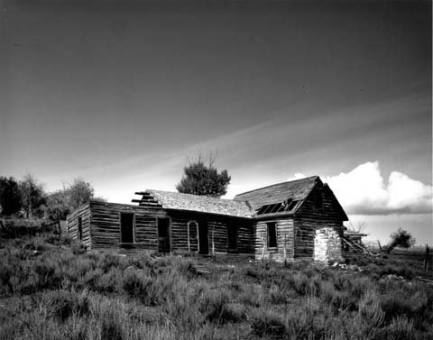
" /><br/><p>Orphaned in her teenage years, Elinore Pruitt Stewart was accustomed to independence. She found employment as a housekeeper for Mrs. Juliet Coney in Colorado after leaving a failed marriage in Oklahoma. In 1909, Elinore decided to seek a more permanent and reliable life for herself and her daughter, Jerrine. Following the advice of her employer and her priest, Elinore began looking for a position as a housekeeper for a homesteader. She accepted a position from Clyde Stewart and moved west to his property in Burntfork, Wyoming.</p><p>That May, she filed for a 160 acre homestead under the Homestead Act on a lot adjacent to Clyde’s. The two married shortly after. She recalled that first summer of work as “the busiest, happiest” she could remember. While the work was hard, it was labor she could “really enjoy.” Over the years, Elinore detailed her life and experiences in Wyoming in letters sent to her friend and previous employer, Mrs. Coney. This collection of letters was later published as a book. It heralded the merits of homesteading as a means for women to provide for themselves. Of women considering the possibility, Elinore wrote, “I feel like urging them every one to get out and file on land… It really requires less strength and labor to raise plenty to satisfy a large family than it does to go out to wash, with the added satisfaction of knowing that their job will not be lost to them if they care to keep it.” She was “very enthusiastic about women homesteading” as a source of autonomy and solution to poverty. In her eagerness for independence and ownership of land, Elinore delayed revealing her new husband to Mrs. Coney until nearly a year after the marriage took place. </p><p>Homestead law required that married women file jointly with their husbands or live separately. Elinore had to relinquish her claim to her mother-in-law in 1912 to avoid losing it completely. She and Clyde later bought the property back once the deed had been acquired. Together they had five children, three of whom survived to adulthood. The family wintered in Boulder, Colorado so their children could attend school there. The remaining months were spent on the ranch, gardening, haying, and caring for livestock. </p><p>In addition to the hard labor, Elinore’s letters described trips with her children or into the mountains. On one such occasion, “after working so hard and so steadily,” she got away by dawn and had a “glorious day” riding in the hills with Jerrine. The publication of her letters brought some notoriety and time was also spent entertaining visitors who came to meet the confident and optimistic woman homesteader.</p><p>Elinore spent her life working and improving the Stewart homestead until her death in 1933. She died of a blood clot to the brain after a surgery following several bouts of serious illness in the years leading to her death. She was buried in Burntfork Pioneer Cemetery, leaving both a historic and a literary legacy that preserves her memory as a successful female homesteader in the American West. </p><p>The ranch continued to be operated by Clyde and their sons until it was leased in 1940 and then sold. The site is now included on the National Register of Historic Places. The homestead building still remains at its original site, although in a much dilapidated condition. There are no current plans to preserve or restore it.</p><p><em><strong><a href="https://www.intermountainhistories.org/items/show/457">For more (including 4 images) view the original article</a></strong></em></p>]]></summary>
    <published>2021-02-07T05:41:39+00:00</published>
    <updated>2026-04-17T19:32:09+00:00</updated>
    <link rel="alternate" type="text/html" href="https://www.intermountainhistories.org/items/show/457"/>
    <id>https://www.intermountainhistories.org/items/show/457</id>
    <author>
      <name>Anna Bailey, Brigham Young University</name>
    </author>
  </entry>
  <entry>
    <title type="html"><![CDATA[Geraldine Lucas, Female Homesteader<br />
]]></title>
    <summary type="html"><![CDATA[<p><strong><em>“They’ll never get me off my land,” vowed Geraldine Lucas. Drawn to Jackson Hole as a beautiful location to retire and by the presence of several siblings, Geraldine became a legendary character of the locale both for her eccentricity and her refusal to sell her land to the National Parks Association. </p></strong></p><img src="https://www.intermountainhistories.org/files/fullsize/59bed290014649aa28d35288cc8edfc5.jpg" alt="Geraldine with other locals during winter
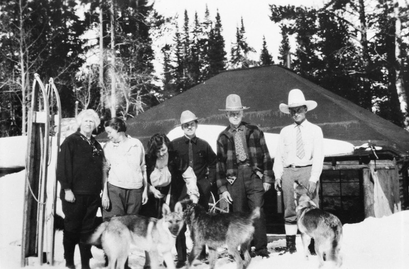
" /><br/><p>Geraldine Lucas was not one to simply comply with traditional norms. At 21, she left a brief but rocky marriage, bringing her son, Russell with her. She then chose to attend school at Oberlin College, becoming both a “returning student” and “single parent” before either term was common. Both Geraldine and Russell had strong personalities, and they clashed over Russell’s educational future spurring him to run away to the Navy. When he returned, they made up, and Geraldine successfully convinced him to join the Coast Guard.</p><p>After she retired in 1913 from teaching public school in New York, Geraldine joined several of her siblings in Jackson Hole, Wyoming where she filed for a 160-acre homestead. Geraldine chose her property as much for the grandeur of the Tetons as for its agricultural potential. She cultivated what was required by law to obtain the property, but then abandoned those efforts and grew only what she needed.</p><p>Geraldine built a cabin and made other improvements, including a second cabin, log storeroom, granary, rabbit hatch, fencing, and over two miles of ditches, all valued at over $7,000. In 1914, she also applied for a timber and stone claim along Phelps Lake, intending to enlarge her landholdings. Geraldine was at odds early on with the federal government due to various errors and complexities associated with her claim. In 1918, when she planned to prove up (colloquial phrase for the legal process of securing title to homestead lands after meeting certain government requirements) on the land, there were complications with the new land office survey and records of intention to file. Geraldine was finally issued her certificate nine years after initiating the process. Then in 1922, Geraldine filed for a desert land entry, but encountered more difficulties with the land office and, ultimately, had to revise the claim from 100 to 70 acres. These frustrations and delays antagonized her against government interference and regulation. Like many Westerners, Geraldine “believed the agency loved technicalities that bordered on harassment.”</p><p>Around 1918, Geraldine persuaded Naomi Colwell to take up an adjacent homestead. At the final proof, Geraldine witnessed that Naomi had no intention to sell her land, a legal requirement, but a short two months later bought 80 acres from her for $500. There were few qualms on the frontier about evading laws or restrictions in the pursuit of additional property. </p><p>In many ways “a loner, ”Geraldine garnered a reputation in Jackson Hole as a man hater. This was reinforced by her efforts to undermine an emerging relationship between Naomi and Russell, as well as run off other potential suitors of the young woman. </p><p>Geraldine spent her summers visiting various family members for weeks at a time, but, come fall and winter, she returned alone to her homestead until spring. She would gather the necessary groceries and wood supply then settle into her books and sewing. A talented seamstress, according to her nephew, she “would sew until hell wouldn’t have it.” Geraldine only ever wore knickers, so it is a mystery what or whom she sewed for. Her personal library consisted of over 1,350 carefully cataloged and numbered books. She also owned a piano, and her home was decorated with gifts from Russell's travels, including a walrus skull and tusks, Kodiak bear head, Eskimo pipe, and reindeer antlers. He also sent a sled and dog team to serve as transport during winter months.</p><p>A mountain climbing craze hit in the 1920s, and Geraldine suddenly had more on her mind than land. In August 1924, age 58, she joined Paul Petzoldt on his climb and became the second woman to summit the crest of the Grand. Instead of warrant accolades, her actions only tended to convince family and neighbors of her eccentricity. As they reached the summit, Petzoldt pushed Geraldine ahead of him so she would be the first on top. He said of her, “I don’t think she often broke through her protected personality, but in that moment when she threw her arms around me with a soft sob, I sensed the real Geraldine Lucas, an intelligent, loving woman who had elected for some reason to leave most of society behind.” Blunt, opinionated, and perhaps unconventional, Geraldine was certainly a character of Jackson Hole. She “simply lived life on her own terms... Yet, much of what set her apart as ‘eccentric’ in her own day, has become commonplace for today’s western women.”</p><p>In the late 1920s, John D. Rockefeller and allies formed a front organization, the Snake River Land Company, to buy property that could be added to the Grand Teton National Park. Many affected by the Great Depression were ready and willing to sell for the fair market prices being offered, but Geraldine was not one of these. Harold Fabian, tasked with buying parcels of land, said of her, “She came out from the east and homesteaded under the Tetons because she wanted to spend the rest of her life within sight of these mountains. She is a lover of beauty and nature.” When offered $50,000 for her homestead, Geraldine responded, “You stack up those silver dollars as high as the Grand Teton and I might talk to you!” She did not share the vision for a national park and had “no use for those who wanted to transform her private playground into a public one.”</p><p>Even amidst the tension of the park property disputes, Geraldine had very pleasant final years on her beloved homestead. She considered making a gift of her land to Oberlin College, but died of heart failure without a will and before any plans were official, so the homestead and property went to Russell. He sold it to a neighbor who sold to Rockefeller who in turn gave it to Jackson Hole Preserve. While Russell never shared his mother’s love for her homestead, he did appreciate it. He placed her cremated remains under a large boulder on her property with a plaque bearing her name and commemorating her memory.</p><p><em><strong><a href="https://www.intermountainhistories.org/items/show/456">For more (including 11 images) view the original article</a></strong></em></p>]]></summary>
    <published>2021-02-06T09:19:15+00:00</published>
    <updated>2026-04-17T19:32:09+00:00</updated>
    <link rel="alternate" type="text/html" href="https://www.intermountainhistories.org/items/show/456"/>
    <id>https://www.intermountainhistories.org/items/show/456</id>
    <author>
      <name>Anna Bailey, Brigham Young University</name>
    </author>
  </entry>
  <entry>
    <title type="html"><![CDATA[Katherine Garetson, Female Homesteader<br />
]]></title>
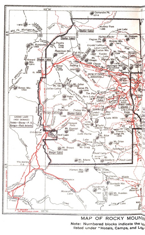
    <summary type="html"><![CDATA[<p><strong><em>Midsummer 1914, Katherine Garetson stood on the front porch of her sister’s mountain cabin and felt herself “whipped and tossed and spattered by a violent storm of wind, rain, thunder, and lightning.” Instead of hating the experience, she wished that “everyone could put into his life one storm of the high mountains.” Katherine saw homesteading as an opportunity for adventure as well as property ownership. </p></strong></p><img src="https://www.intermountainhistories.org/files/fullsize/db41df44e2eae29d90afc2b68b337941.jpg" alt="Map of Estes Park
" /><br/><p>During that 1914 midsummer storm, Katherine offered shelter to a man who had recently established his own homestead in the area, and he related its virtues to her. Katherine wrote that “every American with a spark of romance in his make-up has at some time of his life cherished this idea of taking up a claim.” Her visitor’s words, however, “fell on particularly fertile ground because [she] was seeking escape from the return to St. Louis.” So, in 1914, Katherine Garetson, a single woman in her late thirties from St. Louis, Missouri, filed for a 160-acre claim in Tahosa Valley, Colorado just south of Rocky Mountain National Park.</p><p>Katherine called filing a three-year residence claim “the most serious thing you can do, aside from marrying.” As she considered the possibility, she said “The more I thought, the more I feared. At last I deliberately took the leap as one who shuts his eyes and jumps.” </p><p>Katherine’s cabin on the property was completed just before winter set in. It was given the name Big Owl, a tribute to the great horned owl living nearby. She moved in with two companions, Annie Adele (A.A.) Shreve and Gypsy, a Great Dane. Even with their company, she often felt “desolately lonely and homesick.” With so much to learn and do, Katherine, overwhelmed, “now and then… nearly lost [her] nerve.” Looking back, Katherine commented, “It seems to me that I had an unbearable amount of ignorance to fight against that first year.” </p><p>Fortunately, there were friends who offered kindness and support. With the first big snow, Alfred Oberg “rushed down in the morning… fearing that [they] would not know how to prepare for the storm.” He taught the women tricks to prepare for and survive the long, cold winters. The excitement of Saturday mail was a boost, but also “interfered with a settled content,” reawakening interest in a life from which they “were hopelessly cut off.” </p><p>Katherine endured incredible hardship, poverty, and loneliness, especially after A.A. took a teaching position in Wyoming and Gypsy, who she struggled to feed, had to be given away. The tearoom Katherine operated was only marginally successful. The first summer ended with bills pouring in and Katherine uncertain how she could survive the coming winter. A brief visit with family revitalized her determination and provided her with a wealthy benefactor willing to “take a long chance on a good land proposition.” He gave her a thousand dollars to pay her debts and get restarted.</p><p>Katherine continued her improvements and endured another winter before reporting to the land office in Denver in December 1917 to “prove up” her claim (colloquial phrase for the legal process of securing title to homestead lands after meeting certain government requirements). “Free of all obligations to the government,” she boarded a train for St. Louis. In March, a large envelope arrived from the land office. Instead of containing her patent, it informed her that the Forest Service contested her fulfillment of cultivation requirements. Disregarding the advice of friends and family, she returned, with A.A. to the claim and planted another crop. The next envelope was good news, delivering her patent, the reward of all her labors.</p><p>While Katherine had originally hoped her land “would become valuable as summer cottage sites,” by the end of her proving time, she “was in no hurry to go someplace else to live.” She loved her home, her land, and “the whole mountain world.” She stayed as long as possible, but World War I and the influenza epidemic forced her, financially, to move out to Denver. There, she relied on her stenography and typewriting skills to work for a state senator and later the Secretary of State. She vacationed at Big Owl, “the best loved spot on earth” for years to come, but never lived there again.</p><p><em><strong><a href="https://www.intermountainhistories.org/items/show/454">For more (including 8 images) view the original article</a></strong></em></p>]]></summary>
    <published>2021-02-06T08:37:02+00:00</published>
    <updated>2026-04-17T19:32:09+00:00</updated>
    <link rel="alternate" type="text/html" href="https://www.intermountainhistories.org/items/show/454"/>
    <id>https://www.intermountainhistories.org/items/show/454</id>
    <author>
      <name>Anna Bailey, Brigham Young University</name>
    </author>
  </entry>
  <entry>
    <title type="html"><![CDATA[Zay Philbrook, Female Homesteader<br />
]]></title>
    <summary type="html"><![CDATA[<p><strong><em>“If you have ever ridden up some mountain canyon when your trail led far above the aspen tops into higher silence… in an open world that seemed so full of God and happiness that you wanted to laugh and sob with the joy of living, then I’m sure you understand why we who have been here must always come back.” Zay Philbrook was one of those eternally drawn to the open mountains of the West.</em></strong></p><img src="https://www.intermountainhistories.org/files/fullsize/f970bb5e9d36a2bdc2f98b41a02e367e.jpg" alt="Sketch of Zay Philbrook’s Homestead Cabin" /><br/><p>Zay Philbrook had limited capital but a limitless love for the “glorious heart of Wyoming.” After boarding with a ranger and his family the summer of 1914, Zay was so smitten with her time in the Big Horn mountains that she wanted to stay. With her sister, she rented a small cabin near the town Ten Sleep and searched for land to homestead that suited her means and capabilities. Zay was realistic in her approach to settlement, considering costs of improvements and the physical demands of their completion. The restraints on her funds and time led her to consider a “Timber and Stone” claim. Such claims ranged from 40-160 acres and cost the appraised value of the land and its natural timber or stone. There were no requirements for improvements or time spent occupying the property, so Zay could purchase the patent outright.</p><p>With the help of a ranger, Zay discovered a “quiet, happy little valley fenced by red rimrock and timbered buttes, opening to the south to give a view of the Big Horn basin.” At the head of the valley were several springs that emerged from the hillside, forming a stream that ran the length of the valley. Zay wrote that even with her excitement about the property and its future, she hesitated, asking herself, if once started, she could “see the thing through to the end.” She “looked up at the mountains... measured the responsibility,” and decided she could. Zay had found her claim and, in her words, “All the rest was gladness.”</p><p>A surveyor came out to inspect the property and establish the claim. Zay, like other “timber and stone” claim holders, had to wait nine months before her patent was officially approved. At that time, she made the necessary payments which totaled $520.70 and included surveying, water and timber rights, the property, and all other fees. She paid an old trapper to build her simple one room cabin and made her own closet, shelves, table, and benches. The single room served many purposes and could be adapted to suit a single woman or a half dozen visitors passing through. Zay described it as such a “cosy, warm little room that one forgets winter is drifting down over long miles of mountainside.”</p><p>Economy was considered in all of Zay’s proceedings. She explained her thrift, saying, “Few of us lovers of the West can afford to start such a place just for the pleasure there is in it; we must look for some return for our time and money.” Improvements were viewed as an investment. The property, if necessitated, could be sold for a dude ranch or lambing ground, but Zay’s intentions were to establish a self-supporting ranch. She bought as many horses as she could afford, mainly yearlings. The homestead had only 5-6 irrigable acres and these were cleared of sage brush for a small hay pasture, a vegetable garden, and hardy fruit trees. Vegetables lasted into November and late spring frosts were more of a risk than early fall ones. </p><p>Homestead life was often marked by labor, loneliness, and difficulty, but it was also fulfilling and rewarding. Zay counseled prospective homesteaders to “expect some strenuous days,” but also to “know that every day brings fresh happiness, as you help the claim to grow, as the mountains become more friendly.”</p><p><em><strong><a href="https://www.intermountainhistories.org/items/show/450">For more (including 4 images) view the original article</a></strong></em></p>]]></summary>
    <published>2021-02-03T02:32:12+00:00</published>
    <updated>2026-04-17T19:32:09+00:00</updated>
    <link rel="alternate" type="text/html" href="https://www.intermountainhistories.org/items/show/450"/>
    <id>https://www.intermountainhistories.org/items/show/450</id>
    <author>
      <name>Anna Bailey, Brigham Young University </name>
    </author>
  </entry>
  <entry>
    <title type="html"><![CDATA[Y Mountain]]></title>
    <summary type="html"><![CDATA[<p><strong><em>The construction of the Y Mountain in Provo, Utah is significant to the history and culture of Brigham Young University and Provo.</em></strong></p><img src="https://www.intermountainhistories.org/files/fullsize/a1a9daef1d4a15c98769c2216efd270b.jpg" alt="Y Mountain" /><br/><p>In the early 1900s, a common Latter-day Saint legend described how settlers in Provo were told by Native Americans that they had seen angels who declared that the people in this town would be blessed. Some of those blessings came about through Provo’s Y Mountain. In 1906, the Junior Class of BYU wanted to paint "‘07" on the mountain, upsetting members of the senior class. The President of Brigham Young University at the time, George H. Brimhall, and Brigham Young High School Principal Edwin S. Hinckley settled the argument by deciding that the letters “BYU” would be painted on the mountain. After 6 hours of painting, only the “Y” was completed, so the two other letters “B” and “U” were forgotten, the full plan discontinued. After the completion of the “Y,” students hiked up the mountain annually to re-paint the Y, creating a BYU Y Day tradition. More traditions and plans for the Y mountain would follow for the city of Provo, Utah and its residents. </p><p>The mountain plays an important role in BYU culture and the culture in Provo, Utah. It is the site of many traditions, such as lighting the Y for the holidays, BYU Homecoming, or the success of a school sports team. The tradition of lighting up the Y began in 1924. Another tradition for the incoming Freshman class at BYU involves dedicating a day for a Y mountain hike to celebrate their becoming a BYU Cougar. This tradition has carried through the years. Y mountain has been a symbol for Brigham Young University and the city of Provo, serving as one of the areas main tourist attractions. The traditions that revolve around the Y are important to BYU and Provo culture.</p><p><em><strong><a href="https://www.intermountainhistories.org/items/show/391">For more (including 3 images) view the original article</a></strong></em></p>]]></summary>
    <published>2020-02-18T02:51:08+00:00</published>
    <updated>2026-04-17T19:32:07+00:00</updated>
    <link rel="alternate" type="text/html" href="https://www.intermountainhistories.org/items/show/391"/>
    <id>https://www.intermountainhistories.org/items/show/391</id>
    <author>
      <name>Kayla M. Beck, Brigham Young University</name>
    </author>
  </entry>
</feed>