<?xml version="1.0" encoding="UTF-8"?>
<feed xmlns="http://www.w3.org/2005/Atom">
  <title type="text">Intermountain Histories</title>
  <updated>2026-04-17T19:32:18+00:00</updated>
  <generator uri="http://framework.zend.com" version="1.12.20">Zend_Feed_Writer</generator>
  <link rel="alternate" type="text/html" href="https://www.intermountainhistories.org/"/>
  <link rel="self" type="application/atom+xml" href="https://www.intermountainhistories.org/items/browse?output=rss2"/>
  <id>https://www.intermountainhistories.org/</id>
  <author>
    <name>Intermountain Histories</name>
    <uri>https://www.intermountainhistories.org</uri>
  </author>
  <link rel="hub" href="https://pubsubhubbub.appspot.com/"/>
  <entry>
    <title type="html"><![CDATA[The Round River Rendezvous in Moab 1980]]></title>
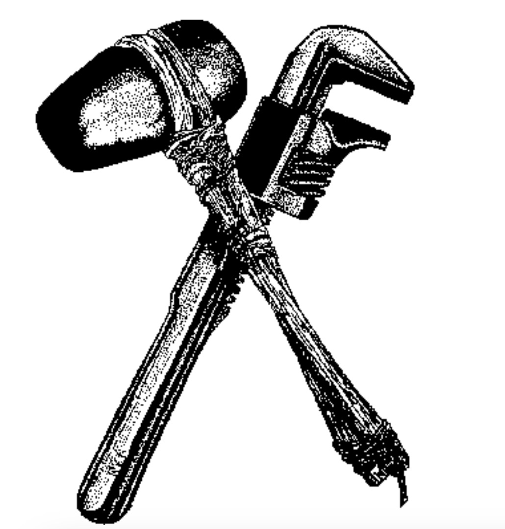
    <summary type="html"><![CDATA[<p><strong><em><span style="font-weight:400;">A newly formed environmental group, </span><span style="font-weight:400;">Earth First</span><span style="font-weight:400;">!, gathered for an annual rendezvous to celebrate and discuss action. Over the decades, the rendezvous became a source of political contention and factionalism.</span></em></strong></p><img src="https://www.intermountainhistories.org/files/fullsize/292b61ee5e90862f570d244c7c58b800.jpg" alt="Earth First logo" /><br/><p><span style="font-weight:400;">In 1980, environmental activists in the Southwest founded Earth First! as a form of radical activism. The group emerged in part as a reaction to dissatisfaction with efforts by mainstream environmental groups, such as the Sierra Club. Earth First! cofounder Dave Foreman emerged as a spokesperson. Foreman had previously worked as an environmental lobbyist, but became disillusioned with what he saw as an ineffective approach. In the </span><span style="font-weight:400;">Earth First</span><span style="font-weight:400;">! Statement of Principles, Foreman wrote that there could be no political compromise in defense of Earth and that all decisions should put Earth first before humankind. The group argued that illegal tactics were warranted, since they viewed democratic processes as having been corrupted by corporate interests. Earth First! prioritized direct action over formal political doctrine, which contributed to a diverse membership with often conflicting ideologies. Direct action entailed taking environmental protection into their own hands, rather than relying on political processes. They took inspiration from Edward Abbey’s writing in </span><i><span style="font-weight:400;">The Monkey Wrench Gang, </span></i><span style="font-weight:400;">in which a fictional group sabotages environmental development that they considered destruction of the Southwest. Ecosabotage and “monkeywrenching” are referenced throughout Earth First! literature.</span>
<span style="font-weight:400;">Earth First! began hosting the Round River Rendezvous in 1980, an annual meeting for members. The name of the meeting, according to urban legend, comes from an Ojibwe myth about a continuous river of life. They held the first rendezvous near Moab, Utah. Each year, the location of the annual meeting shifts to different locations throughout the West. According to the </span><i><span style="font-weight:400;">Earth First! Journal</span></i><span style="font-weight:400;">, the rendezvous sites are chosen based on remoteness, natural beauty, and proximity to a site being threatened with development. In 1980, the rendezvous coincided with plans by Utah’s Grand County Commission to send a bulldozer into a Bureau of Land Management Wilderness Study Area near Moab.</span>
<span style="font-weight:400;">The rendezvous served as an opportunity for community and celebration, as well as a site to discuss conservation issues and plan direct action. The rendezvous featured activist workshops, music and poetry, and demonstrations. The </span><i><span style="font-weight:400;">EF Journal</span></i><span style="font-weight:400;"> also encouraged wilderness exploration, such as hiking in the area. By the end of the decade, the togetherness of the Round River Rendezvous shifted into a venue for intense factionalism. The group became divided on a number of issues, most significantly regarding the push towards increasingly extremist direct action including using illegal and violent means to protect the environment.  Other debates focused on racism, sexism within the group, and advocacy for animals. The 1987 rendezvous at the Grand Canyon was marked by especially harsh division between new leftist or anarchist members and older members of the group, including intense criticism of attendee Edward Abbey. By this point, Dave Foreman and other co-founders began to distance themselves from the group, as they became concerned with the new trajectory. </span>
<span style="font-weight:400;">The Round River Rendezvous today still serves as an opportunity for environmentalists to gather in celebration. </span><span style="font-weight:400;">The Earth First</span><span style="font-weight:400;">! agenda has become more inclusive and diversified since the early years, and no longer focused on the environment as their sole issue.</span></p><p><em><strong><a href="https://www.intermountainhistories.org/items/show/834">For more (including 3 images) view the original article</a></strong></em></p>]]></summary>
    <published>2024-05-27T14:58:20+00:00</published>
    <updated>2026-04-17T19:32:18+00:00</updated>
    <link rel="alternate" type="text/html" href="https://www.intermountainhistories.org/items/show/834"/>
    <id>https://www.intermountainhistories.org/items/show/834</id>
    <author>
      <name>Emily Roth, Northern Arizona University</name>
    </author>
  </entry>
  <entry>
    <title type="html"><![CDATA[Grandstaff Canyon: A Beautiful Place with a Complicated Naming History]]></title>
    <summary type="html"><![CDATA[<p><strong><em>Grandstaff Canyon was renamed in 2017 due to its controversial name. Previously  known as Negro Bill Canyon since the 1940’s, this historical location provides a rich  history and provokes deep thought into how that history should be portrayed. </em></strong></p><img src="https://www.intermountainhistories.org/files/fullsize/a6af9c137339bb03665ba3a182d5f9d3.jpg" alt="Walking trail through Grandstaff Canyon" /><br/><p><span style="font-weight:400;">Beginning in the 1940’s, Negro Bill Canyon was an official place on the map, located just outside of Moab, Utah. The canyon was named after William Grandstaff. For the  past 20 years, questions have surrounded its controversial name and whether it should be changed out of respect for William Grandstaff or kept in order to maintain history. Ultimately, a federal board voted to change the canyon's name to Grandstaff Canyon in 2017. </span>
<span style="font-weight:400;">William Grandstaff’s life was a bit of a mystery, although some basic facts are known. In the 1830s, William Grandstaff was born into slavery in Shenandoah County, Virginia. During the first 30-40 years of his life, Grandstaff made his way across the country. After a stop in Cincinnati, Ohio, where Grandstaff fought in the Black Brigade of Cincinnati during the Civil War, he made it to the Moab area in 1877. Grandstaff first resided in an abandoned LDS fort that had been constructed during a period of conflict between the settlers and local Utes. Grandstaff was a frontiersman and one of the first non-native settlers in the area. His presence in Moab helped to promote settlement in the area.  </span>
<span style="font-weight:400;">Grandstaff ranched, grew crops, and had a large herd of cattle. Due to the stream and trees that provided shade, the canyon was perfect for agriculture and ranching. Local Indigenous people visited the canyon to trade with Grandstaff. Today, this area is used as a beautiful recreational area for local hikers and visitors to explore. By changing the name  of the canyon, its visitors can now hold deeper respect, appreciation, and curiosity for William Grandstaff, one whose legacy is still remembered by the people of Moab.</span></p><p><em><strong><a href="https://www.intermountainhistories.org/items/show/650">For more (including 4 images) view the original article</a></strong></em></p>]]></summary>
    <published>2022-09-14T18:50:03+00:00</published>
    <updated>2026-04-17T19:32:14+00:00</updated>
    <link rel="alternate" type="text/html" href="https://www.intermountainhistories.org/items/show/650"/>
    <id>https://www.intermountainhistories.org/items/show/650</id>
    <author>
      <name>Addison Ashby, Brigham Young University</name>
    </author>
  </entry>
  <entry>
    <title type="html"><![CDATA[The Creation of Canyonlands National Park<br />
]]></title>
    <summary type="html"><![CDATA[<p><strong><em>Although the area of Canyonlands National Park enthralled many visitors for years before the creation of a national park there, the road to becoming federally protected land took many years, controversies, and compromises. </em></strong></p><img src="https://www.intermountainhistories.org/files/fullsize/8560da34733564e52bd87816ca22e0b7.jpg" alt="View of Shafer Trail " /><br/><p>Situated about 40 minutes from Moab, Utah, Canyonlands National Park is the largest and most remote of all the National Parks in the state. Covering 337,589 acres, the park is split into three major districts by the Colorado and Green rivers known as the Islands in the Sky, The Needles, and The Maze. The Park is also famous for being the location where the two rivers meet, and home to many ruins and artifacts from ancient peoples who lived there thousands of years ago. Despite the area of the park being famous for its natural wonders, the creation of the park was a long and arduous process that included many controversies and compromises. </p><p>Serious consideration for creating the area into a National Park grew in the early 1960s after the election of President John F. Kennedy and his appointment of Stewart Udall as Secretary of the Interior. Udall believed heavily in conservation and was enthralled by the beauty of the area when he visited in 1961. Recruiting Utah Senator Frank Moss as an ally for the project, the two set out to preserve the Canyonlands area as a National Park. Immediately, Udall and Moss ran into opposition from other local legislators including Utah Senator Wallace Bennett. While Bennett was not completely opposed to the idea of a National Park in the Canyonlands region, he wanted a much smaller protected area in order to keep most of the region open for commercial use. Bennett thought that much of the area was better suited for mining, drilling, and grazing. </p><p>Senators Moss and Bennett fought for a few years before a final proposal was sent to the United States Congress in 1964. This proposal included most of the area that Moss and Udall wanted to have protected, but removed a portion from the north side of the park for commercial developments at the wish of Bennett and other local people. Moss continued to fight to protect more of the land around Canyonlands for the rest of his tenure as senator in Utah and is a large reason that the park is enjoyed by thousands today.</p><p><em><strong><a href="https://www.intermountainhistories.org/items/show/647">For more (including 4 images) view the original article</a></strong></em></p>]]></summary>
    <published>2022-09-12T21:18:55+00:00</published>
    <updated>2026-04-17T19:32:14+00:00</updated>
    <link rel="alternate" type="text/html" href="https://www.intermountainhistories.org/items/show/647"/>
    <id>https://www.intermountainhistories.org/items/show/647</id>
    <author>
      <name>Allie Castañeda and Forrest Filetti, Brigham Young University </name>
    </author>
  </entry>
  <entry>
    <title type="html"><![CDATA[Utah: the Uranium Capital of the World]]></title>
    <summary type="html"><![CDATA[<p><strong><em>Uranium mining in Utah boomed as the United States began their nuclear build up following World War II. Although Utah’s uranium boom was short lived, it had long lasting consequences.</em></strong></p><img src="https://www.intermountainhistories.org/files/fullsize/b558090454af8e077dc39fc14f92f561.jpg" alt="Uranium Tailings Cleanup" /><br/><p>Before World War II, uranium was considered an unlucrative resource to mine. However, the United States' dropping of the atomic bombs changed the worth of the element. Nuclear weapons, such as the atomic bomb, are made from uranium: a heavy element which, when split, causes extreme heat and pressure, and thus, astonishing damage. Shortly after World War II, the United States engaged in a cold, non-combatant conflict with their former ally, the Soviet Union. These superpowers engaged in competition on all fronts, including in sports, space, and nuclear build up. Four years after the United States dropped the atomic bombs, the Soviet Union successfully tested atomic bombs of their own, thus igniting an arms race. </p><p>During this time of nuclear build up, the value of uranium surged. The U.S. Atomic Energy Commission began offering huge sums of money for miners. In 1952, Charles Steen, an unemployed and unsuccessful geologist, moved his family into a trailer in the middle of the desert as he began the search for uranium near Moab. He discovered an ore bed worth more than $60 million dollars. His discovery drew many miners to Moab in search of uranium. Soon Utah was dubbed “The Uranium Capitol of the World.” Between the years of 1946 and 1959, there were 309,380 claims of uranium found in Utah, and by 1955, there were about 800 operating mines. The uranium boom brought other businesses to Moab and the city began to grow exponentially. Other uranium rich mining towns in Utah enjoyed similar growth. However, the uranium boom was short lived, peaking in 1958 and declining in the 1960s. </p><p>Today, Moab and other uranium mining towns are tourist destinations where people can hike, mountain bike, and rock climb. Nevertheless, Uranium mining has had long lasting implications for its communities. Many of these communities are affected by poverty, natural resource dependence for economic growth, and great social inequalities and divisions. Longtime residents have experienced serious illnesses such as cancer due to their exposure to Uranium. Despite these impacts, residents of the uranium regions continue to support the industry because of their tie to its history, their patriotism, and their ongoing hope for a booming economy.</p><p><em><strong><a href="https://www.intermountainhistories.org/items/show/646">For more (including 3 images) view the original article</a></strong></em></p>]]></summary>
    <published>2022-09-12T19:17:52+00:00</published>
    <updated>2026-04-17T19:32:14+00:00</updated>
    <link rel="alternate" type="text/html" href="https://www.intermountainhistories.org/items/show/646"/>
    <id>https://www.intermountainhistories.org/items/show/646</id>
    <author>
      <name>Lexi Bradshaw, Brigham Young University</name>
    </author>
  </entry>
  <entry>
    <title type="html"><![CDATA[Dark Sky over Arches National Park]]></title>
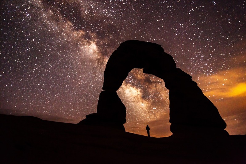
    <summary type="html"><![CDATA[<p><strong><em>Home to over 2,000 natural sandstone arches in Utah, Arches National Park applied for recognition from the International Dark-Sky Association and received the association’s “Silver Tier” designation in 2019 thanks to its commitment to preserving the natural sky and educating the public about the benefits of reducing light pollution.</em></strong></p><img src="https://www.intermountainhistories.org/files/fullsize/94128d7b834b011c0b21f969610c1bc6.jpg" alt="Milky Way over Arches" /><br/><p>First designated a national monument in 1929, Congress declared Arches a national park on November 12, 1971. Arches National Park is one of the “Mighty 5” national parks of Utah, and in 2019, the International Dark-Sky Associated recognized the park’s work toward reducing light pollution within and outside of the park with its Silver Tier designation. (The Silver Tier is given when light glow is present along the horizon to a degree that wildlife and astronomy are impacted, but the Milky Way Galaxy can still be seen in summer and winter with over six thousand stars visible to the naked eye.)
In 1999, a study of 376 parks discovered that half of all National Parks, 189 in total, were threatened by light pollution from encroaching cities. The National Park Service responded by forming the Night Sky Team to document the negative effects of light pollution with 104 photos taken in a short duration. Every photo was stitched together to form a wider picture, and then the Night Sky Team erased the light generated by stars to focus on how artificial lighting impacted the park. Arches National Park in 2003 had significant light pollution from Moab, Utah, and Grand Junction, Colorado, so the park created outdoor lighting codes with training workshops to reduce light pollution, intending to keep visitors safe while minimizing harm to wildlife.
Arches National Park’s lighting codes implement several strategies for reducing light pollution and preserving a clear night sky as a culture heritage. First, Arches’ lights use motion sensors to provide visitors with light when they need it without leaving any running constantly. Second, Arches’ outdoor light fixtures are shielded with hoods and point toward the ground. Third, Arches National Park uses warm-colored light, as blue-colored light negatively impacts insects while amber lighting minimizes sky brightness while still providing visibility to guests. Fourth, Arches encourages nearby cities and households to plan outdoor lighting efficiently and use high quality lights. This includes striving to minimize nighttime lighting and only using what is strictly necessary for public safety.  Close to 100% of all exterior lights throughout the 119-square-mile park are night-sky friendly in accordance with Arches’ principles.
The value Arches National Park places on its dark skies is not limited to lighting codes and stargazing within the park. Educational outreach programs have been created, like the Night Sky Ranger booklet that teaches children about astronomy and light pollution through stargazing and moon phase observation activities. Preservation can maintain the dark skies, but education about the value of dark skies is what will break through the night blindness created by brightly lit societies.</p><p><em><strong><a href="https://www.intermountainhistories.org/items/show/541">For more (including 5 images) view the original article</a></strong></em></p>]]></summary>
    <published>2021-11-14T03:31:12+00:00</published>
    <updated>2026-04-17T19:32:11+00:00</updated>
    <link rel="alternate" type="text/html" href="https://www.intermountainhistories.org/items/show/541"/>
    <id>https://www.intermountainhistories.org/items/show/541</id>
    <author>
      <name>Emma Svenson, Northern Arizona University</name>
    </author>
  </entry>
  <entry>
    <title type="html"><![CDATA[Moab’s Uranium Mill Tailings Pile<br />
]]></title>
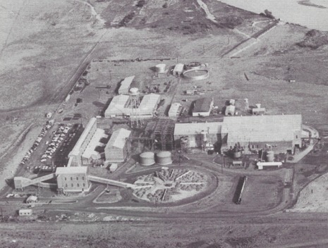
    <summary type="html"><![CDATA[<p><strong><em>Moab, known in the 1950s as the “Uranium Capital of the World,” is now better known as the home of Arches and Canyonlands National Parks. However, hikers, campers, rock climbers, and mountain bikers who visit Moab ought to be aware of the town’s connections to uranium mining. Every day, 136 containers of radioactive waste are transported alongside the highway that visitors take to get to either park. Furthermore, those who visit Lake Powell or Mead, the Grand Canyon, or any section of the Colorado River south of Moab ought to be aware of the 10.8 million tonnes of radioactive tailings that are being transported to a safer site but currently sit a few hundred feet away from the river.</p></strong></p><img src="https://www.intermountainhistories.org/files/fullsize/3646cbeb4873f2970c61de3905c3825d.jpg" alt="The Uranium Reduction Company Mill" /><br/><p>Outdoor enthusiasts are drawn to Moab because of its location along the Colorado River and its proximity to both Arches and Canyonlands National Park. The federal government has taken an active role in the conservation of land and wildlife in the area, but it has also partnered with entrepreneurs in the private sector who mined for uranium ore, a radioactive mineral that exists in abundance in parts of the southwest. Moab is a town where opposites meet—clean soil meets radioactive dust. The air, while fresh, could be dangerous to visitors who camp or kayak downwind from its massive uranium mill tailings pile.</p><p>During the Cold War, the U.S. military encouraged prospectors to search for uranium ore to create stockpiles of atomic and hydrogen bombs to defend against the Soviets. In 1952, thirty-two-year-old prospector Charles Steen discovered the country’s largest uranium deposit in Moab. Ore was extracted at the Mi Vida Mine and processed at the nearby Uranium Reduction Company. After it was processed, the hazardous waste was deposited in an unlined pond adjacent to the Colorado River. In 1962, Steen sold the processing company, which continued as the Atlas Uranium Mill. In 1984, the mill was permanently closed and the pond was covered. However, given the site’s proximity to the Colorado, pollutants from the waste began to leech into the river—one of America’s most important rivers, which is a source of drinking water for more than 40 million people and flows through Las Vegas’s Lake Mead.</p><p>In 2001, management of the site was transferred to the U.S. Department of Energy. In 2005, it announced that 10.8 million tonnes of the radioactive tailings would be moved from along the Colorado River, mostly by rail, and buried in a lined hole in Crescent Junction, twenty-eight miles north of Moab. The first relocation occurred in 2008 and might take more than twenty years to complete. Although a radiological survey has verified that the containers have no radioactive material on the outside, Dr. Gene Cole, a retired BYU professor and an environmental health specialist, has argued that it is impossible to completely prevent harmful tailings from spreading along the route, which passes alongside and under U.S. Route 191. Inconveniently, this state highway is the one that most drivers take when visiting Arches and Canyonlands National Parks, as well as iconic Monument Valley. In July 2014, the 7 millionth ton of tailing was placed in the Crescent Junction holding cell, where it should be secured. Nevertheless, who really knows how much radioactive dust blows off along the way?</p><p><em><strong><a href="https://www.intermountainhistories.org/items/show/216">For more (including 3 images) view the original article</a></strong></em></p>]]></summary>
    <published>2018-06-12T01:26:29+00:00</published>
    <updated>2026-04-17T19:32:03+00:00</updated>
    <link rel="alternate" type="text/html" href="https://www.intermountainhistories.org/items/show/216"/>
    <id>https://www.intermountainhistories.org/items/show/216</id>
    <author>
      <name>Marc Jonathan Wein, Brigham Young University</name>
    </author>
  </entry>
  <entry>
    <title type="html"><![CDATA[Charles Steen’s Former Hilltop Mansion<br />
]]></title>
    <summary type="html"><![CDATA[<p><strong><em>After climbing, camping in, or hiking through the National Parks that surround Moab, visitors might want to eat at a family-owned restaurant—The Sunset Grill. Before its transformation into a restaurant, this complex was the mansion of multi-millionaire uranium miner Charles Steen, a visionary prospector whose rags to riches (and back to rags) story still resonates with those who have seen the best and worst of times.</p></strong></p><img src="https://www.intermountainhistories.org/files/fullsize/1c696df5a134bb4118b5bc82e7ea351f.jpg" alt="The Steen family, from left to right: M.L., Butch, Charles, Jr., Mark, Charlie, Andy, and Johnny.
" /><br/><p>Each year, over 1.5 million outdoor enthusiasts visit Arches National Park, a mountain biker, hiker, and rock climber paradise, located outside of Moab. One popular restaurant where adrenaline junkies and nature lovers can refill is Sunset Grill, currently owned by a former aerospace engineer and a nightclub manager from Pennsylvania who moved to Moab in 1993. But before it was a restaurant, the site was the hilltop mansion built and owned by Charles Steen, a “rags to riches uranium boom king” who made his fortune in the 1950s.</p><p>In the early 1940s, Steen studied geology at the Texas College of Mines and Metallurgy (today the University of Texas at El Paso). After working in South America as a petroleum geologist and then in Texas for Standard Oil Company, Steen was fired for insubordination and blacklisted by the industry. In the December 1949 issue of the The Engineering and Mining Journal, he learned that the Atomic Energy Commission, desperate to supply uranium for the government’s nuclear weapons program, “established minimum prices, guaranteed the rates for ten years, and added a $10,000 bonus for each separate discovery . . . of high-grade uranium from new deposits.” Steen headed west. He, his wife, and four sons moved around in trailers and backcountry, tarpaper shacks for almost two years. Finally, on 6 July 1952, Steen struck big at Mi Visa Mine near Moab, which shipped a million dollars’ worth of ore in its first six months. Before then, he had been sustaining his family on a “diet of potato chips and bananas.” His son recalls that they had been “living in a $15 a month shack, unencumbered with running water or electricity.” But Steen’s willpower paid off. Moab, a sleepy town, became home to a millionaire.</p><p>He quickly built a $250,000 hilltop mansion in Moab, replete with a swimming pool, greenhouse, and even servants’ quarters. Steen also lived lavishly by purchasing a private plane, which he flew to Salt Lake City for weekly dancing lessons. Although he spent much of his money lavishly, Steen was known as a friendly man who gave to the community. Every year, he invited the entire population of Moab to annual parties and donated $50,000 toward a local hospital. His discovery put Moab on the map as the “Uranium Capital of the World” and created hundreds of jobs. He was elected to the Utah State Senate in 1958, but when the country had obtained enough ore and stopped supporting his prices, he suffered heavy financial losses. After he declared bankruptcy in 1968, the IRS seized his assets. Although he went from rags to riches, then lost his riches, Steen’s mansion, now a restaurant, is still open for business, overlooking the town like he once did.</p><p><em><strong><a href="https://www.intermountainhistories.org/items/show/214">For more (including 3 images) view the original article</a></strong></em></p>]]></summary>
    <published>2018-06-11T22:31:24+00:00</published>
    <updated>2026-04-17T19:32:03+00:00</updated>
    <link rel="alternate" type="text/html" href="https://www.intermountainhistories.org/items/show/214"/>
    <id>https://www.intermountainhistories.org/items/show/214</id>
    <author>
      <name>Marc Jonathan Wein, Brigham Young University</name>
    </author>
  </entry>
</feed>