<?xml version="1.0" encoding="UTF-8"?>
<feed xmlns="http://www.w3.org/2005/Atom">
  <title type="text">Intermountain Histories</title>
  <updated>2026-04-17T19:32:12+00:00</updated>
  <generator uri="http://framework.zend.com" version="1.12.20">Zend_Feed_Writer</generator>
  <link rel="alternate" type="text/html" href="https://www.intermountainhistories.org/"/>
  <link rel="self" type="application/atom+xml" href="https://www.intermountainhistories.org/items/browse?output=rss2"/>
  <id>https://www.intermountainhistories.org/</id>
  <author>
    <name>Intermountain Histories</name>
    <uri>https://www.intermountainhistories.org</uri>
  </author>
  <link rel="hub" href="https://pubsubhubbub.appspot.com/"/>
  <entry>
    <title type="html"><![CDATA[Grand Lodge of Montana]]></title>
    <summary type="html"><![CDATA[<p><strong><em>The Grand Lodge of Montana is a nexus of Freemason history. Both a museum and active Freemason meeting place, the Grand Lodge of Montana in Helena, Montana, hosts a collection of Freemason artifacts including Meriwether Lewis’s masonic apron, O. C. Seltzer’s painting of Montana’s first Freemason meeting, and a hand-written manuscript of Paris Pfouts, the first mayor of Virginia City.</em></strong></p><img src="https://www.intermountainhistories.org/files/fullsize/1924df9fce1df17eaa5523622e003f16.jpg" alt="Masonic apron of Meriwether Lewis" /><br/><p>The Grand Lodge of Montana, headquarters for Montana Freemasons, was built in Helena in 1868. Freemasonry affected Montana’s history from its earliest beginnings, as Masonic lodges were among the first social organizations in the first Montana mining camps. The Grand Lodge is a home to this history, acting as a library and museum full of historical artifacts, including, most famously, Meriwether Lewis’s masonic apron.
Lewis considered his masonic apron one of his most prized possessions, a remarkable feeling for a man who had collected so many valuable artifacts during his legendary expedition with William Clark. When Lewis perished from mysterious gunshot wounds while traveling the Natchez Trace in October 1809, his masonic apron may have been in his pocket. Lewis’s masonic apron is an important artifact, as Lewis was likely the first Freemason to travel through the land that became Montana, and the Montana freemasons went to great lengths to acquire it. Grand Master Joseph Hopper of Billings purchased Lewis’ apron in 1960, and it became the crown jewel of the Grand Lodge’s collection.
Another famous masonic artifact housed in the Grand Lodge of Montana is O. C. Seltzer’s painting of the first masonic meeting in Montana at Mullan Pass. The painting depicts three Freemasons camping together high in the Rocky Mountains on September 23, 1862. Those who visit the Grand Lodge of Montana today may view this original freemason meeting painted by Seltzer. From 1868 until the present, Freemasons have actively held meetings in this impressive Art Deco structure.</p><p><em><strong><a href="https://www.intermountainhistories.org/items/show/586">For more (including 3 images) view the original article</a></strong></em></p>]]></summary>
    <published>2022-04-09T07:34:26+00:00</published>
    <updated>2026-04-17T19:32:12+00:00</updated>
    <link rel="alternate" type="text/html" href="https://www.intermountainhistories.org/items/show/586"/>
    <id>https://www.intermountainhistories.org/items/show/586</id>
    <author>
      <name>Benjamin Nielsen, Brigham Young University</name>
    </author>
  </entry>
  <entry>
    <title type="html"><![CDATA[Jean-Baptiste Charbonneau’s Grave]]></title>
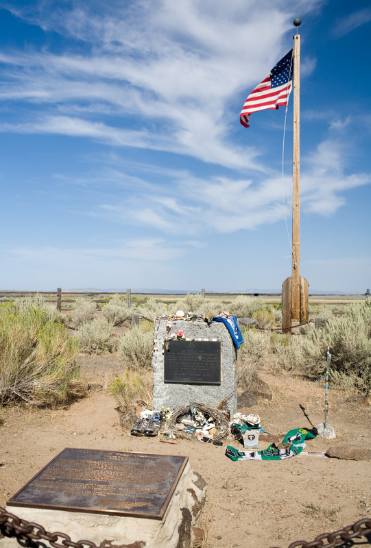
    <summary type="html"><![CDATA[<p><strong><em>Born in February 1805, Jean-Baptiste Charbonneau accompanied the Lewis and Clark Expedition as an infant before becoming a fur trader, guide, alcalde, and then a hotel manager in California.</em></strong></p><img src="https://www.intermountainhistories.org/files/fullsize/01db17a0c012fd0f8a8d4751a3066439.jpg" alt="Charbonneau gravesite" /><br/><p>Jean-Baptiste Charbonneau, son of Sacagawea and Toussaint Charbonneau, accompanied his parents on Meriwether Lewis and William Clark’s expedition for the Corps of Discovery. Although a small infant, he made the entire trek from North Dakota to the Pacific Coast and back to the Mandan Villages on the Knife River. After Sacagawea’s death in December 1812, William Clark legally adopted Jean-Baptiste and his little sister Lisette. Clark provided an education for the two children at a Catholic boarding school in St. Louis. This education opened up numerous opportunities for Jean-Baptiste throughout his life.
As an adult, Jean-Baptiste spent a substantial amount of time in Europe where he learned additional languages and skills. Returning to America, he joined the fur trade, working as a trapper with the Rocky Mountain Fur Company. His extensive knowledge of the terrain enabled him to serve as a guide for explorers, as well as for the Mormon Battalion on their route from Leavenworth to San Diego in 1846 during the Mexican–American War.
While in California, Charbonneau worked as an alcalde (mayor), panned for gold, provided interpretation services, and operated a hotel in Auburn, California. After the American Civil War and toward the end of his life, Charbonneau worked odd jobs until he learned about gold and silver strikes in Idaho and Montana. On his way to the mining rushes he traveled through Danner, Oregon, but shortly after crossing the Jordan Creek and the Owyhee River, he fell ill (likely of pneumonia) and died at sixty-one years old. Oregonians memorialized Charbonneau by erecting and dedicating a plaque to him in Danner. His place of death is located just over the border of Oregon and is close to the Lemhi Shoshone Nation of Idaho, the likely birthplace of his mother, Sacagawea.</p><p><em><strong><a href="https://www.intermountainhistories.org/items/show/585">For more (including 3 images) view the original article</a></strong></em></p>]]></summary>
    <published>2022-04-09T07:02:41+00:00</published>
    <updated>2026-04-17T19:32:12+00:00</updated>
    <link rel="alternate" type="text/html" href="https://www.intermountainhistories.org/items/show/585"/>
    <id>https://www.intermountainhistories.org/items/show/585</id>
    <author>
      <name>Taylor Mansfield, Brigham Young University</name>
    </author>
  </entry>
  <entry>
    <title type="html"><![CDATA[Sacagawea Birthplace]]></title>
    <summary type="html"><![CDATA[<img src="https://www.intermountainhistories.org/files/fullsize/da84f7bf86bc77b6104e4c22670e6f59.jpg" alt="Lemhi" /><br/><p>More than two centuries have passed since the Lewis and Clark Expedition traveled to the Pacific and back, and the expedition and its members continue to generate interest. Aside from the leaders, Meriweather Lewis and William Clark, Sacagawea may be the best-known member of the expedition. When she was around sixteen years old, she gave birth to her first child, Jean Baptiste Charbonneau. Two months later she departed on the expedition with her husband and child in tow. She made it the entire journey while carrying and tending to her child and simultaneously helping the efforts of the expedition.
Her main role in the expedition was as an interpreter between the party and Shoshones. She was likely born into the Lemhi Shoshone tribe around 1788, and her birthplace may have been somewhere between Kenney Creek and Agency Creek in Tendoy, Idaho.  Since the Lemhi Shoshone lived along the river, they fished for salmon as a dietary staple. From a young age, Sacagawea contributed to her family by gathering and preparing food. Recently, oral histories have made claims Sacagawea was Hidatsa, not Shoshone. While there is currently some controversy surrounding precisely what tribe Sacagawea came from, history does not dispute that Sacagawea lived part of her life with the Hidatsas. She did tell Lewis and Clark that she was captured while traveling across the Rocky Mountains and adopted into the Hidatsa Nation as a child and her new name was Sacagawea, meaning Bird Woman or Eagle Woman. It is likely that she learned additional agricultural skills from the Hidatsas, where she resided until her marriage as a plural wife to Toussaint Charbonneau, a French-Canadian explorer.
Although forced to leave her childhood homeland in Idaho, Sacagawea returned to the Lemhi Valley with Lewis and Clark, reuniting with the Shoshones. She then reunited with her tribal family in the place she was born and celebrated her reunion with her brother Cameahwait before continuing her journey to the Pacific.</p><p><em><strong><a href="https://www.intermountainhistories.org/items/show/584">For more (including 3 images) view the original article</a></strong></em></p>]]></summary>
    <published>2022-04-08T04:34:55+00:00</published>
    <updated>2026-04-17T19:32:12+00:00</updated>
    <link rel="alternate" type="text/html" href="https://www.intermountainhistories.org/items/show/584"/>
    <id>https://www.intermountainhistories.org/items/show/584</id>
    <author>
      <name>Taylor Mansfield, Brigham Young University</name>
    </author>
  </entry>
  <entry>
    <title type="html"><![CDATA[Sacagawea’s Alleged Gravesite]]></title>
    <summary type="html"><![CDATA[<p><strong><em>American icon Sacagawea was instrumental in the Lewis and Clark expedition. However, the circumstances surrounding her death and even when and where she died are murky and hotly contested.</em></strong></p><img src="https://www.intermountainhistories.org/files/fullsize/0deae90765f5318925358d115eade6c9.jpg" alt="Mountains at Wind River" /><br/><p>Sacagawea has inspired countless girls to have greater strength and courage in their lives. Around age 16, this Lemhi Shoshone young woman joined Lewis and Clark on their journey across the American West, acting as an interpreter and occasional guide. She did this while carrying her baby Jean Baptiste upon her back. What the Lewis and Clark Expedition achieved was impressive, but what Sacagawea achieved seems heroic and unimaginable.
Despite the important place Sacagawea holds in American history, the stories regarding her death remain contested. Some insist she died in December 1812 in South Dakota at the age of 24. Others contend she lived to age 96 and died on the Wind River Indian Reservation in Wyoming Territory in 1884, reunited with her Shoshone kinsmen. The Hidatsa use Sacagawea (meaning Bird Woman or Eagle Woman). Shoshones used Sacajawea (meaning boat-pusher).
Between 1825 and 1828, William Clark created a list of the expedition members of the Corps of Discovery and identified where each of them were. Next to Sacagawea’s name he wrote, “dead.” This matches other primary accounts that record one of Toussaint Charbonneau’s wives died at Fort Manuel in December 1812. Additional primary sources indicate that Clark adopted her two children, Jean Baptiste and Lisette, the following year in 1813, offering additional credence to the notion that she likely died in December 1812.
Clark’s record conflicts with Shoshone oral histories about Bird Woman’s life and death recorded by University of Wyoming historian Grace Hebard in the early twentieth century. She interviewed several Shoshones and recorded their traditions. They described Sacagawea having left her abusive husband Charbonneau and traveled to Colorado territory to live with her cousins, the Comanches. She purportedly married a warrior named Jerk Meat, raised a family, and eventually returned home to live out her twilight years with the Eastern Shoshone on the Wind River Reservation. There she lived out her last days with her son Jean Baptiste and eventually died in peace. Her son is also reported by some to have died there and to be buried in an unmarked grave somewhere in the Wind River Mountain range. Other accounts clearly identify Jean Baptiste Charbonneau as dying in Danner, Oregon in 1866.
It is conceivable that these oral accounts attributed to the Bird Woman may also refer to another Shoshone woman who had life experiences similar to Sacagawea. No matter where her final resting place is, the grave in the Ethete cemetery marked with Sacajawea’s name stands as an important historical landmark because of how it honors this great Shoshone woman, pays tribute to her memory, and recognizes her contributions to history. While the spot marked here at the Sacajawea Cemetery near Fort Washakie, Wyoming may not be her actual resting place, it is still a remarkable place to visit for any American who wants to celebrate the life of this great explorer, or for any woman who wants to connect with a true heroine.</p><p><em><strong><a href="https://www.intermountainhistories.org/items/show/579">For more (including 3 images) view the original article</a></strong></em></p>]]></summary>
    <published>2022-03-12T09:50:55+00:00</published>
    <updated>2026-04-17T19:32:12+00:00</updated>
    <link rel="alternate" type="text/html" href="https://www.intermountainhistories.org/items/show/579"/>
    <id>https://www.intermountainhistories.org/items/show/579</id>
    <author>
      <name>Sara Grundvig, Brigham Young University</name>
    </author>
  </entry>
  <entry>
    <title type="html"><![CDATA[Weippe Prairie Exploration ]]></title>
    <summary type="html"><![CDATA[<p><strong><em>Originally a major transportation and trade junction for the Nez Perce and their neighbors, Weippe Prairie became the location for a pivotal moment in US history in September 1805. The Nez Perce welcomed the Lewis and Clark expedition there and established a friendly relationship between the United States and the Nez Perce Nation that lasted into the 1850s. </em></strong></p><img src="https://www.intermountainhistories.org/files/fullsize/5bae0596c4e3ef4ffe9e5e6f4b994891.jpg" alt="Weippe Praire" /><br/><p>More than two hundred years ago, Weippe Prairie was a major transportation and trade junction for the Nez Perce Nation. The prairie was simply called Weippe by those living in the area (Weippe being derived from the Nez Perce term <em>Oyáyp</em>). Weippe Prairie was also one of the main root-gathering grounds, with American Indians from different bands making the journey to Weippe to harvest the root <em>qém’es, </em>later called the “camas” root by explorers.
On September 20, 1805, Lewis and Clark exited the Lolo Trail over the Bitterroot Mountains and entered Weippe Prairie. Clark took a scouting party and went ahead where they were met by Al-We-Yas, a Nez Perce village leader and the brother of Chief Twisted Hair. Al-We-Yas approached Clark’s group with caution. Unbeknownst to Clark, Chief Peo-Peo-Tah-Likt had strategically sent Nez Perce warriors to surround Clark’s group, waiting for any hostile movements. This is the first recorded historical meeting between Nez Perce leaders and US representatives. Al-We-Yas sent messengers to neighboring tribes announcing the coming of the Americans. This also represented a moment prophesied by American Indian spiritual leaders, which caused many chiefs and village leaders to make decisions concerning their relationship with the Americans. They debated whether to kill them or establish a peaceful and friendly relationship with them. Because Clark had made a favorable impression on Chief Twisted Hair and his son, the village leaders decided not to kill Lewis and Clark’s exploration group. This interaction was a pivotal moment in the life of Chief Twisted Hair’s son, Aleiya, who would later be known as Chief Lawyer. Chief Lawyer would go on to become one of the most influential advocates for an alliance between the US government and the Nez Perce Indians.
<span>Nez Perce were greatly generous toward Lewis and Clark’s exploration group. In addition to feeding the famished explorers, Nez Perce also provided geographical knowledge so they could navigate the Clearwater River. They also tended the expedition's horses throughout the winter while the group travelled to the coast and back.</span> On September 24, the Lewis and Clark exploration departed the Nez Perce village and continued via dugout canoes on to the Pacific. The following year on their return journey in 1806, Lewis and Clark reunited with the Nez Perce on their return journey and stayed with them for up to seven weeks while waiting for the snow to melt in the Bitterroot Mountains.</p><p><em><strong><a href="https://www.intermountainhistories.org/items/show/479">For more (including 3 images) view the original article</a></strong></em></p>]]></summary>
    <published>2021-09-11T08:44:58+00:00</published>
    <updated>2026-04-17T19:32:10+00:00</updated>
    <link rel="alternate" type="text/html" href="https://www.intermountainhistories.org/items/show/479"/>
    <id>https://www.intermountainhistories.org/items/show/479</id>
    <author>
      <name>Haley Hakala, Brigham Young University</name>
    </author>
  </entry>
  <entry>
    <title type="html"><![CDATA[Sulphur Springs]]></title>
    <summary type="html"><![CDATA[<p><strong><em>Sulphur Springs is located on the north bank of the Missouri River in Montana. The springs aided one of the best-known expeditions in American History. </em></strong></p><img src="https://www.intermountainhistories.org/files/fullsize/5332bd6600b597af7d7a2aaf90fc3741.jpg" alt="Labeled Map of Sulphur Spring" /><br/><p>The Sulphur Springs area of the Missouri River was used by Lewis and Clark on their expedition. Meriwether Lewis’ journal recounted that Sacagawea took ill near these banks saying “our Indian woman sick and low spirited." Her “pulse were scarcely perceptible, very quick frequently irregular and attended with strong nervous symptoms, that of the twitching of the fingers” which worried the party because of her value on the journey as well as for the health of her baby.</p><p>Lewis noticed the Sulphur Springs and wrote that “the water is a transparent as possible strongly impregnated with Sulphur…” which he deducted was similar to the sulphur spring which he had been acquainted with in Virginia, his home state. He was familiar with their medicinal qualities and used the water to help in healing Sacagawea. Lewis administered treatments of the sulphur water for her to drink with poultices of barks and laudanum. The treatments had positive effects: “now the pulse had become regular much fuller and a gentle perspiration had taken place; the nervous symptoms have also in a great measure abated, and she feels herself much freer from pain. She complains principally of the lower region of the abdomen, I therefore continued the cataplasms of barks and laudnumn.” </p><p>Recent analysis of Sulphur Spring by geologists indicates that the dissolved minerals in the water may have restored blood electrolytes and aided in the treatment of Sacagawea, which was needed because Lewis had bled her and performed sweating to rid her of her illness. Ironically, Lewis’ other treatments might have caused more harm, but the sulphur water helped her recover in two days and the expedition continued their journey.  </p><p><em><strong><a href="https://www.intermountainhistories.org/items/show/414">For more (including 3 images) view the original article</a></strong></em></p>]]></summary>
    <published>2020-03-25T02:42:59+00:00</published>
    <updated>2026-04-17T19:32:08+00:00</updated>
    <link rel="alternate" type="text/html" href="https://www.intermountainhistories.org/items/show/414"/>
    <id>https://www.intermountainhistories.org/items/show/414</id>
    <author>
      <name>Shelby Benally, Brigham Young University</name>
    </author>
  </entry>
  <entry>
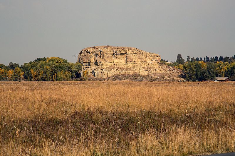
    <title type="html"><![CDATA[Pompeys Pillar National Monument]]></title>
    <summary type="html"><![CDATA[<p><strong><em>Pompeys Pillar is an impressive sandstone formation standing nearly 200 feet above the Yellowstone River. Designated as a national monument in 2001, the pillar features numerous Native American petroglyphs, as well as marks and drawings made by travelers and settlers. The most notable mark on this historic rock, however, is the signature of the great explorer William Clark, who named the pillar after Sacagawea’s son.</p></strong></p><img src="https://www.intermountainhistories.org/files/fullsize/11cc09f1ff08529113f7496d29342260.jpg" alt="Pompeys Pillar" /><br/><p>The summer of 1806 found Lewis and Clark’s Corps of Discovery on their return trip from the Pacific Ocean to St. Louis. Led by Meriwether Lewis and William Clark, the band of explorers, which initially consisted of some 55 people, had traveled from St. Louis, Missouri to the Pacific Ocean. President Jefferson had tasked them to find a viable water route to the Pacific Coast. Moreover, they discovered 178 new plants species and 122 animal species. They charted and mapped the rivers and mountains of the plains and Rockies and established friendly relations with many Native American tribes.</p><p>On June 30, 1806, the Corps were returning home when they decided to make a brief stop at a meadow along the Bitterroot River known as Traveler’s Rest. During that stay, Lewis and Clark determined to divide their forces into different groups so that they could explore as much territory as possible. Clark and Sacagawea, a Shoshone woman, led their party through the Bozeman Pass. They constructed cottonwood log canoes to float down the Yellowstone River. After floating for several days, Clark spotted an enormous rock structure on July 25 and decided to stop and climb it. In his journal Clark recorded, “At 4PM [I] arrived at the remarkable rock situated in an extensive bottom. This rock I ascended and from it's top had a most extensive view in every direction. This rock which I shall call Pompy's Tower is 200 feet high and 400 paces in secumpherance and only axcessible on one side which is from the N.E. the other parts of it being a perpendicular clift of lightish coloured gritty rock.The Indians have made 2 piles of stone on the top of this tower. The nativs have ingraved on the face of this rock the figures of animals &c.” </p><p>Clark named the large sandstone rock Pompys Tower after Sacagawea’s son Jean Baptiste Charbonneau, who Clark nicknamed “Pomp” and who would eventually become Clark’s adopted son. Clark also carved his now famous inscription on the pillar, including his name and the date, July 25, 1806. This mark is one of the few visible remnants of expedition along the Lewis and Clark National Historic Trail.</p><p><em><strong><a href="https://www.intermountainhistories.org/items/show/413">For more (including 3 images) view the original article</a></strong></em></p>]]></summary>
    <published>2020-03-25T00:48:08+00:00</published>
    <updated>2026-04-17T19:32:08+00:00</updated>
    <link rel="alternate" type="text/html" href="https://www.intermountainhistories.org/items/show/413"/>
    <id>https://www.intermountainhistories.org/items/show/413</id>
    <author>
      <name>Rulon Udall, Brigham Young University</name>
    </author>
  </entry>
  <entry>
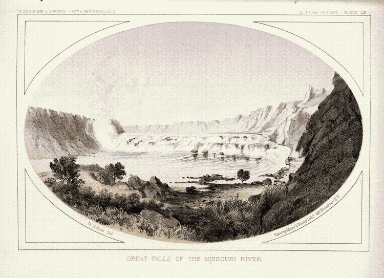
    <title type="html"><![CDATA[The Great Falls Portage]]></title>
    <summary type="html"><![CDATA[<p><strong><em>In an unprecedented journey, the Lewis and Clark Expedition traveled nearly 8,000 miles across the newly-acquired Louisiana Purchase of the Northwestern half of the United States. Yet, of those 8,000 miles, the 21-mile on-foot portage around the Great Falls of the Missouri River were possibly the most gruesome and tiring of the entire voyage. </em></strong></p><img src="https://www.intermountainhistories.org/files/fullsize/649e436c528bb13cd37be0ee31b8deff.jpg" alt="&quot;Great Falls of the Missouri River&quot;" /><br/><p>The Lewis and Clark Expedition—or the Corps of Discovery, as it was officially known—reached the Great Falls of the Missouri River on June 13, 1805. The company was elated to arrive at the falls, becoming the “first white men to see the Great Falls of the Missouri River.” However, the grandeur and majesty of the falls meant that the company’s original path along the Missouri River was temporarily unsuitable for their trek. Consequently, they, along with all their cargo, would have to travel by land to circumvent the cascades. </p><p>The portage posed several challenges from unwelcome wildlife encounters to cached cargo and extreme physical exertion and injuries. When the corps realized that they would be unable to proceed by water, they spent several days creating wagons to tow their canoes, equipment and supplies. They cut small sections of tree trunks for the wheels, and used ropes, like they had on the water, to haul their canoes and cargo over steep and rough terrain. After only a few miles, the company was tormented by prickly pear cactus spines that easily poked through their moccasins into their feet, heatstroke, hail storms, and a plague of pests. On July 24, 1805, Meriwether Lewis lamented that "our trio of pests still invade and obstruct us on all occasions, these are the Musquetoes eye knats and prickley pears, equal to any three curses that ever poor Egypt laiboured under.” He continued: “at every halt these poor fellow tumble down and are so much fortiegued that many of them are asleep in an instant. In short their fatiegues are incredible; some are limping from the soreness of their feet, others faint and unable to stand for a few minutes, with heat and fatiegue, yet no one complains. All go with cheerfulness . . . “</p><p>If the 21-mile path through the Great Falls had been an ordinary stretch of the Missouri River, it would have taken only one or two days to travel; however, the portage around the Great Falls of the Missouri took the company over a month between June 13, 1805 and July 15, 1805. </p><p><em><strong><a href="https://www.intermountainhistories.org/items/show/411">For more (including 3 images) view the original article</a></strong></em></p>]]></summary>
    <published>2020-03-19T02:06:54+00:00</published>
    <updated>2026-04-17T19:32:08+00:00</updated>
    <link rel="alternate" type="text/html" href="https://www.intermountainhistories.org/items/show/411"/>
    <id>https://www.intermountainhistories.org/items/show/411</id>
    <author>
      <name>Lexi Vaughan, Brigham Young University</name>
    </author>
  </entry>
  <entry>
    <title type="html"><![CDATA[John Colter’s Run]]></title>
    <summary type="html"><![CDATA[<p><strong><em>John Colter was a celebrated mountain man and explorer who lived during the nineteenth century. He was a member of the Lewis and Clark Expedition and went on to explore many parts of the American West, including the future Yellowstone National Park in 1807-1808.</em></strong></p><img src="https://www.intermountainhistories.org/files/fullsize/202cde90c5adda9ef7220fdf6d5fddd4.jpg" alt="John Colter’s Escape" /><br/><p>While canoeing the Jefferson River near the Missouri River’s headwaters trapping beavers in 1809, John Colter and his companion, John Potts, were called ashore by a large party of Blackfoot Indians. Colter knew about the Atsinas and Blackfoot Confederacy as powerful native nations allied with the British and had fought them several times in 1807 and 1808. Colter obediently went to shore and beckoned Potts to join him. Potts, however, moved his canoe back into the water and shot and killed one of the Blackfoot. Blackfoot warriors shot Potts with numerous arrows, killing him. </p><p>Once ashore, the Blackfoot stripped Colter of his clothing. After the Blackfoot deliberated how to kill him, the chief decided to allow Colter to run for his life. The Blackfoot took Colter to a nearby plain where the race would take place. Allowing Colter a three to four hundred yard start, the chief instructed Colter to run, and then allowed five to six hundred members of the tribe to chase after Colter. Colter, who was familiar with this tradition, knew that he must outrun the Blackfoot if he had any chance of surviving. After running several miles across the plain, Colter looked over his should to find that only one of the Blackfoot was successful in catching up to him. With a newfound confidence and determination, Colter continued to run with all his might until he was in sight of the Missouri River when again, Colter turned his head to find his pursuer about twenty yards behind him. Colter stopped suddenly to confront the Indian and, using the man’s own spear, successfully killed him. Colter continued running and found refuge at a bank in the river, where Colter hid under driftwood or a beaver lodge.</p><p>Shortly after Colter found refuge, he heard the nearby shrills of the rest of the Blackfoot, who traveled up and down the river looking for him. Colter hid there until night, when he could no longer hear the Blackfoot. From his hiding spot, Colter swam down the river and traveled all night until he was a great distance from the Blackfoot. Out of the grasp of the Blackfoot, Colter still faced danger. He was exhausted from his run, frozen from the river, completely naked, and prickly pear thorns pierced his feet. Miraculously, Colter successfully traveled to Manuel Lisa’s Fort Raymond within seven days, surviving only on roots. As John Bradbury described Colter’s triumph, “These were circumstances under which almost any man but an American hunter would have despaired.”</p><p><em><strong><a href="https://www.intermountainhistories.org/items/show/401">For more (including 3 images) view the original article</a></strong></em></p>]]></summary>
    <published>2020-03-08T04:43:49+00:00</published>
    <updated>2026-04-17T19:32:08+00:00</updated>
    <link rel="alternate" type="text/html" href="https://www.intermountainhistories.org/items/show/401"/>
    <id>https://www.intermountainhistories.org/items/show/401</id>
    <author>
      <name>Meg Kelly, Brigham Young University</name>
    </author>
  </entry>
  <entry>
    <title type="html"><![CDATA[Historic Travelers through Lolo Pass<br />
]]></title>
    <summary type="html"><![CDATA[<p><strong><em>While journeying to their Pacific destination, a Shoshone guide led Lewis and Clark’s Corps of Discovery across the Bitterroot Mountains through what would later be named Lolo Pass. Soon after they left the pass behind, they learned that Native peoples used it to gain access to bison hunting territory.</em></strong></p><img src="https://www.intermountainhistories.org/files/fullsize/471fa83f0f8e8e5363b1fc21a635e0b9.jpg" alt="Panorama of Lolo Pass" /><br/><p>After leaving their camp at Traveler’s Rest, the Corps of Discovery, led by captains Meriwether Lewis and William Clark encountered one of the most grueling stretches of their expedition. The Shoshones advised them against descending the Snake River to the Pacific Ocean, and so their alternate route necessitated going through a mountain pass farther north. Later named “Lolo Pass,” the mountain gap the Corps crossed aided their overall westward progress but inaugurated one of the most difficult parts of their journey.   Over the course of eleven days, they experienced treacherous slopes and contours of the Bitteroot Mountains.  Their Shoshone guide nicknamed “Old Toby” told them their travel through the mountains would take six days.  This miscalculation was, oddly enough, due in part to his guiding the party down “a wrong road,” taking them “out of [their] rout 3 miles” before falling back into “the right road.”  Nevertheless, the party crossed over Lolo Pass, the currently-demarcated border between Idaho and Montana on the Continental Divide.  They passed several hot springs on their way through, stopping briefly to test (and even taste) the water, and discovered that it was “hot & not bad tasted.”  After Lewis’s cohort caught up with Clark’s, they set up camp near Pack Creek, specifically on the lower end of Packer Meadows in Idaho County, Idaho.</p><p>Having successfully traversed the mountains (albeit with much difficulty), the party stepped off the Lolo Trail to enjoy the hospitality, food, and shelter of the Nez Perce tribe, located at Weippe Prairie.  After encamping together, the Nez Perce informed the party of travelers that the trail the party took was an older trail the Nez Perce had been using to go east to hunt for deer and bison, as well as to procure horses and rendezvous with other tribes (sometimes with the unfortunate result of combating their enemies, losing tribespeople and horses in the process).  Interestingly, the expedition members noticed signs of the trail and pass being used on the first day they set out to cross the Bitterroots, as they “passed a tree on which was a nomber of Shapes drawn on it with paint by the natives,” among other signs that they supposed to be “a place of worship among them [the Indians].”  They also saw “pine trees pealed as far up as a man could reach,” assuming that the natives had done so to mix the inside bark of the trees with dried fruit to eat.  They also posited that at the hot springs “one of the Indians had made a whole to bathe [in].”  Before leaving the Nez Perce to sail on the Columbia River, the party learned that the Nez Perce “make great use of Swetting,” referring to the tribe’s use of “hot and cold baethes,” which were used to treat skin diseases on account of the supposed healing properties of hot springs’ water.  On the return trip home, some expedition members and natives “amused themselves” by fully utilizing the springs near Lolo Pass, a welcome warmth and delight after “bid[ding] adieu to the snow” and remembering the hardships they had previously experienced in crossing the Rocky Mountains.</p><p><em><strong><a href="https://www.intermountainhistories.org/items/show/399">For more (including 5 images) view the original article</a></strong></em></p>]]></summary>
    <published>2020-03-07T00:38:47+00:00</published>
    <updated>2026-04-17T19:32:08+00:00</updated>
    <link rel="alternate" type="text/html" href="https://www.intermountainhistories.org/items/show/399"/>
    <id>https://www.intermountainhistories.org/items/show/399</id>
    <author>
      <name>Jacob Bailey, Brigham Young University</name>
    </author>
  </entry>
</feed>