<?xml version="1.0" encoding="UTF-8"?>
<feed xmlns="http://www.w3.org/2005/Atom">
  <title type="text">Intermountain Histories</title>
  <updated>2026-04-17T19:32:14+00:00</updated>
  <generator uri="http://framework.zend.com" version="1.12.20">Zend_Feed_Writer</generator>
  <link rel="alternate" type="text/html" href="https://www.intermountainhistories.org/"/>
  <link rel="self" type="application/atom+xml" href="https://www.intermountainhistories.org/items/browse?output=rss2"/>
  <id>https://www.intermountainhistories.org/</id>
  <author>
    <name>Intermountain Histories</name>
    <uri>https://www.intermountainhistories.org</uri>
  </author>
  <link rel="hub" href="https://pubsubhubbub.appspot.com/"/>
  <entry>
    <title type="html"><![CDATA[Strawberry Reservoir and Ute Lands]]></title>
    <summary type="html"><![CDATA[<p><strong><em>Strawberry Reservoir is known for being a popular fishing and camping spot and is an important contributor to irrigation needs along the Wasatch Front. A lesser known attribute of the reservoir is the cost in Ute Indian lands.  </em></strong></p><img src="https://www.intermountainhistories.org/files/fullsize/eccbf60b145ad9fa7819f9fe935a27c9.jpg" alt="A Map of Strawberry Valley" /><br/><p><span style="font-weight:400;">Strawberry Reservoir is located on the eastern edge of the Wasatch Mountains of Utah, nestled in Strawberry Valley east of Spanish Fork and southeast of Heber City. A tunnel four miles long runs through the Wasatch mountains and carries water from Strawberry Reservoir to the Spanish Fork River, a vital resource for agriculture in Utah Valley.</span>
<span style="font-weight:400;">The reservoir’s history for Utah settlers began at the very start of the twentieth century, when the availability of irrigation water was a major concern for farmers of Utah’s arid lands. While traveling through Strawberry Valley on a camping trip, John S. Lewis and Henry Gardner first thought of building the reservoir and a water transport system. Gardner, a Utah State Senator at the time, was aware of the dire water problem for Utah’s population centers along the Wasatch Front. The idea of the reservoir proved to be an effective solution. A few years later, in 1906, construction began on the Strawberry Valley Project. The resulting Strawberry Reservoir was completed less than a decade later.</span>
<span style="font-weight:400;">Although water diverted from the Strawberry Reservoir helped Utah Valley farmers irrigate their crops, the creation of the reservoir was devastating to the Ute Indians in the area. For years, the tribe had experienced varied encroachments of tribal land by white farmers who violated the law in doing so. Farmers grazed their cattle in Strawberry Valley and used water that belonged to reservation lands. Such actions not only posed a threat to Ute resources, but represented a disregard for Ute legitimacy. Earlier offenses were magnified by the Strawberry Reservoir project. The project neglected to consult the Ute tribe on its construction. Among the consequences of the project, the reservoir opened reservation lands to future developments like mining and white settlements, solidifying the loss for the Ute tribe. </span></p><p><em><strong><a href="https://www.intermountainhistories.org/items/show/652">For more (including 3 images) view the original article</a></strong></em></p>]]></summary>
    <published>2022-09-15T21:17:15+00:00</published>
    <updated>2026-04-17T19:32:14+00:00</updated>
    <link rel="alternate" type="text/html" href="https://www.intermountainhistories.org/items/show/652"/>
    <id>https://www.intermountainhistories.org/items/show/652</id>
    <author>
      <name>Marvin Reed Hatch III, Brigham Young University</name>
    </author>
  </entry>
  <entry>
    <title type="html"><![CDATA[Lake Lowell: Transforming Treasure Valley]]></title>
    <summary type="html"><![CDATA[<p><strong><em>The Reclamation Act of June 17, 1902, aimed to create proper irrigation systems that could provide water access for residents of western states. Lake Lowell was one of those projects.</em></strong></p><img src="https://www.intermountainhistories.org/files/fullsize/8dafc9cce562e3302960bcf13f35ebe2.jpg" alt="Building up" /><br/><p>Under the direction of the 1902 Reclamation Act—congressional legislation intended to irrigate western states and provide greater access to water—the Bureau of Reclamation approved and developed Lake Lowell, starting in 1902 and finishing in 1909. Three dams—the Upper, Middle, and Lower Embankments (embankments are walls of earth or stone built to prevent a river from flooding an area)—surround a natural depression southwest of Nampa, Idaho to form the lake. A fourth wall, called the East Embankment, was added later to protect farmsteads on the eastern end of the reservoir.
In the irrigation off-season, the Boise River Diversion Dam and New York Canal provide most of Lake Lowell’s volume, discharging water intp the upper end of the lake, where there is a capacity ranging from 12.7 feet on the Middle Embankment to 65 feet on the Upper. During the irrigation season, Lake Lowell becomes one of the major irrigation providers for Canyon County agriculture. With the capacity to irrigate over 200,000 acres of land, it is one of the American West’s largest off-stream reservoirs.
As with many other western irrigation projects, Lake Lowell presented a significant opportunity for economic growth and restructured the relationship between people and their environment. Along with other government investment projects that opened the area to construction and farming, irrigation attracted migrants from the Midwest who worked as laborers to develop the dam and as farmers to till the land. In 1900, the census counted 161,772 people living in Idaho; by the 1920 census, the population had more than doubled to 431,866 people. This growth was sharpest in southwestern Idaho, which grew by 130% during this twenty-year period as agricultural and ex-urban communities transformed Treasure Valley into fertile land. Lake Lowell made that change possible.
In addition to serving local farms, towns, and cities, Lake Lowell also plays a role in how people and other living things interact with the region’s nature. The lake hosts the Deer Flat Reservoir, one of the oldest refuges in the National Wildlife Refuge System. As for humans in nature, Lake Lowell is a popular destination for numerous outdoor activities, including boating, swimming, fishing, birdwatching, hiking, and hunting.</p><p><em><strong><a href="https://www.intermountainhistories.org/items/show/629">For more (including 5 images) view the original article</a></strong></em></p>]]></summary>
    <published>2022-06-30T21:27:42+00:00</published>
    <updated>2026-04-17T19:32:13+00:00</updated>
    <link rel="alternate" type="text/html" href="https://www.intermountainhistories.org/items/show/629"/>
    <id>https://www.intermountainhistories.org/items/show/629</id>
    <author>
      <name>Legna Roximar Morales, College of Idaho</name>
    </author>
  </entry>
  <entry>
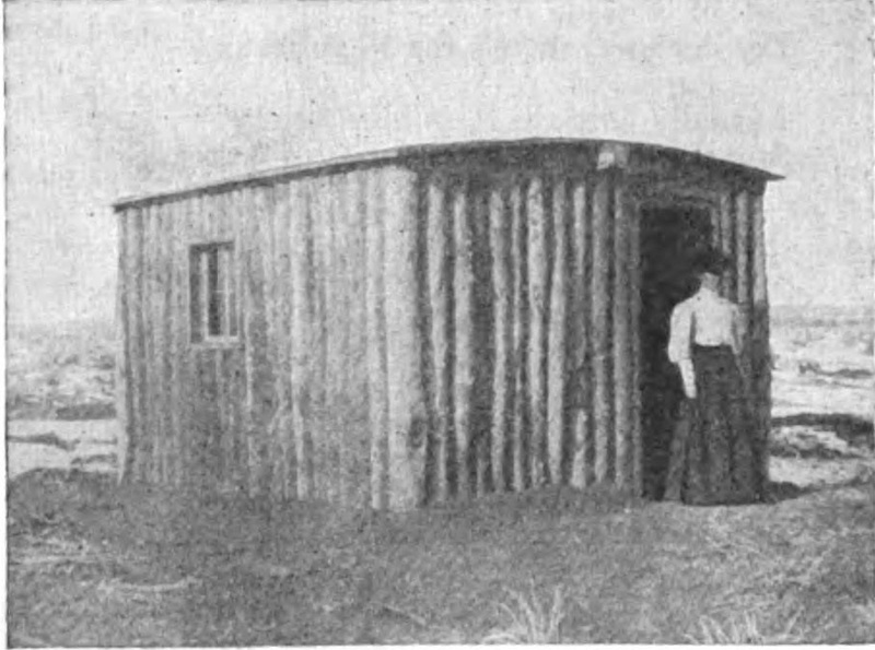
    <title type="html"><![CDATA[Kate Heizer, Female Homesteader<br />
]]></title>
    <summary type="html"><![CDATA[<p><strong><em>Of homesteading, Kate Heizer wrote, “One inquirer has an exaggerated idea of the difficulties and hardships. Another has a mistaken notion of taking a pleasant vacation while waiting till he receives title to a piece of property that will place him above financial anxiety for the rest of his life.” As for herself, Kate recognized the truth lay somewhere in the middle. </p></strong></p><img src="https://www.intermountainhistories.org/files/fullsize/5dff0bee6f413282d2b91a59c25175a3.jpg" alt="First Cabin on Heizer Claim" /><br/><p>The Dawes Severalty Act of 1887 authorized and began a process of subdividing reservation lands among Native families, breaking up and diminishing Native landholdings, including the Uintah Indian Reservation. In August 1905, “surplus” land was opened to homesteading and mineral claims. Kate Heizer was only one of thousands who applied for property in these areas. Preference for pieces of property was decided by drawing lots and Kate picked #247, low when compared to other higher possible picks. Time for potential homesteaders to look over the available land was short. Wasatch Land Company and other professional “locators” promised to identify prime lots for a price, but, with high stakes, there was a general mistrust of anyone claiming to know anything. </p><p>Potential for success rested all on the decision of what piece of land was selected. Prospective owners frantically learned all they could of sagebrush and other indicators of soil quality. Kate was skeptical of her ability to choose, writing, “I was as little capable of judging [the land] as I am of discussing the canals on Mars.” She questioned and listened to everyone who could give her any information, carefully judging “which men really understood conditions and were giving honest advice, and which either mistakenly thought they knew or had interested motives.” Her biggest concern was how the property would be irrigated, so she decided largely based on where others gathered, hoping that community would increase value and ensure a greater effort and feasibility for irrigation schemes. Kate’s study and planning paid off and she “secured a better claim than many a one who had had an earlier choice.”</p><p>The filing took place in early fall and, once settled, Kate returned to her teaching job to finish out the school year. To fulfill settlement requirements, she “resided” on her homestead for several days during the Christmas break. It was common for individuals to leave for periods to save money to fund work done in the spring. There were lonely spells as people moved in and out. Contests were raised, occasionally, against abandoned claims and Kate had one filed against herself in her absence. Fortunately, empathetic neighbors “with unmistakable western emphasis” advised the man to drop it—and he did. The incident spurred Kate to move out permanently and begin her required 14 months of continuous residence. The first summer was a difficult season. Many homesteaders needed ditches that didn’t yet exist to access water. Kate was fortunate in that her property was within a gully that retained water into midsummer and provided shade that grew trees for lumber. Once it was completed, she paid $1.25 per acre to the Indian Fund and, in exchange, received her patent. </p><p>Supplies had to be freighted in and were expensive to acquire. When funds ran dry, Kate had to sell 50 acres to continue improvements to the rest of her land. She was tormented by rabbits and prairie dogs that ate her crops and gardens, making “scarecrows, guns, and poison... futile.” Despite its difficulties, she persevered, seeing homesteading as an opportunity to learn and a cause for hope. Kate planted 90 acres of alfalfa and studied agriculture so she could take over management of her ranch entirely. </p><p>Regarding success, Kate explained that “the man who is alert and ready to seize opportunities, who holds to a purpose until it is accomplished, is the man most likely to succeed in any undertaking, and homesteading is no exception.” She certainly followed her own advice. While Kate took pride in becoming successful and competent, she found something even more gratifying—“the realization of being an important factor in the community, one whose voice has weight, a person to be consulted about matters of public interest.” Through her hard work and determination, Kate found success, independence, and political influence as a single woman in the American West.</p><p><em><strong><a href="https://www.intermountainhistories.org/items/show/455">For more (including 4 images) view the original article</a></strong></em></p>]]></summary>
    <published>2021-02-06T08:54:57+00:00</published>
    <updated>2026-04-17T19:32:09+00:00</updated>
    <link rel="alternate" type="text/html" href="https://www.intermountainhistories.org/items/show/455"/>
    <id>https://www.intermountainhistories.org/items/show/455</id>
    <author>
      <name>Anna Bailey, Brigham Young University</name>
    </author>
  </entry>
  <entry>
    <title type="html"><![CDATA[The Kennedy Ditch<br />
]]></title>
    <summary type="html"><![CDATA[<p><strong><em>The Kennedy Ditch was an irrigation ditch named after its first watermaster, Charles Kennedy, who was one of the earliest pioneers settling in Utah. Dug in the early 1850’s by several families living in the vicinity, including the Kennedy’s, for many years it served as an important water source for several blocks in Salt Lake City. </em></strong></p><img src="https://www.intermountainhistories.org/files/fullsize/3ab62c33096f1d1a132d1dad298b8e03.jpg" alt="Kennedy Ditch Plaque" /><br/><p>For the first pioneers arrived in Utah in 1848 creating a settlement in the Salt Lake Valley was a daunting task. One of the biggest problems they faced was a severe shortage of water sources which greatly limited the agricultural potential of the area. To overcome this limitation, the settlers worked together to dig irrigation ditches and created a system of water rights that was unlike that of anywhere else in the continent.</p><p>The Kennedy Ditch was one of these innovative irrigation canals. It was created as a cooperative work project among the settlers and was taken out of a stream in Parley’s Canyon, near the street 17th East. It helped to irrigate and bring under cultivation 864 acres of farmland in the Salt Lake settlement, which extended west from the street 13th East and North from 21st South to 9th South.</p><p>The Kennedy Ditch was named after its first watermaster, Charles Kennedy. Kennedy was part of the first wave of pioneers who arrived in the valley in 1848. His life demonstrates many of the peculiarities of the lives of the Latter Day Saints of this time, particularly the unique community organization, and both the successes and failures of living in this way.</p><p>The highly structured community organization of the Latter-day Saint pioneers is a large part of what allowed them to flourish in the inhospitable Utah environment. Nowhere is this more clear than in the unique system of water rights and distribution that they established. Charles Kennedy played a role in this early organization, and he and the Kennedy Ditch provide a microcosm of the work, triumphs, and failures that went into the establishment of the Latter Day Saint society in Utah.</p><p><em><strong><a href="https://www.intermountainhistories.org/items/show/434">For more (including 3 images) view the original article</a></strong></em></p>]]></summary>
    <published>2020-10-14T05:31:15+00:00</published>
    <updated>2026-04-17T19:32:08+00:00</updated>
    <link rel="alternate" type="text/html" href="https://www.intermountainhistories.org/items/show/434"/>
    <id>https://www.intermountainhistories.org/items/show/434</id>
    <author>
      <name>Emma Burns, Brigham Young University</name>
    </author>
  </entry>
  <entry>
    <title type="html"><![CDATA[The Palisades Dam: Irrigation of the Snake River]]></title>
    <summary type="html"><![CDATA[<p><strong><em>This giant dam is an important structure in the economy of this area.  It prevents millions of dollars of flood damage every year and provides water for the farmers in the area.  It also fosters the recreation industry that is very strong in this area.  It is both an incredible landmark and a symbol for the success of the region. </em></strong></p><img src="https://www.intermountainhistories.org/files/fullsize/f8198694e23134cf593e29d52881c413.jpg" alt="Valley Before the Dam" /><br/><p>The largest dam in the area, the Palisades dam was build long after the other dams were completed.  After the success of the American Falls, Minidoka, and Jackson Dam, the Bureau of Reclamation realized that most of the dams supplied water to farmers in the lower area of the valley, while those in the upper valley struggled to find access to enough water, especially during drought years.  The Bureau began investigating new sites for one more dam in the area.  A number of surveyed sites were dismissed due to poor geology, and surveyors looked for a site that would create a sufficiently high reservoir while not being extremely high, to minimize the risk of failure.  Eventually, the Grand Valley site was selected, and renamed the Palisade site to avoid confusion with other projects in Colorado.</p><p>Construction began in 1946 and was finished by 1957.  The reservoir holds over a million acre feet of water, making it the second largest reservoir in the region, following the American Falls reservoir.  It provides water to about 650,000 acres of farm land, helping to grow grain, beans, potatoes, sugar beets, other vegetables, and many other seeds.  It serves as a home to many cutthroat trout, as well as other species of fish found in the area.  The power plant installed inside the dam generates a total of 176,600 kilowatt hours, enough to power a few hundred homes.  According to estimates by the Bureau of Reclamation, this dam helps produce almost $1 billion of services, accounting for the irrigation to crops, livestock fed, and recreation on the reservoir and the river.</p><p>One of the main purposes of the dam is flood control, helping to keep the amount of water steady throughout the year.  The Bureau estimates that this dam has prevented over $250 million of damages to farms and property, making it the largest contribution of a single dam to the prevention of flood damage.  One of its most well-known uses is for recreation.  The reservoir itself has over 70 miles of shore line and has become a popular fishing spot for local anglers.</p><p><em><strong><a href="https://www.intermountainhistories.org/items/show/92">For more (including 4 images) view the original article</a></strong></em></p>]]></summary>
    <published>2017-09-06T03:15:02+00:00</published>
    <updated>2026-04-17T19:31:59+00:00</updated>
    <link rel="alternate" type="text/html" href="https://www.intermountainhistories.org/items/show/92"/>
    <id>https://www.intermountainhistories.org/items/show/92</id>
    <author>
      <name>Josh Franzen, Brigham Young University</name>
    </author>
  </entry>
  <entry>
    <title type="html"><![CDATA[Minidoka Dam and Lake Walcott]]></title>
    <summary type="html"><![CDATA[<p><strong><em>Helping to turn a desert into farmland, this dam is an important element of the modern ecosystem of the area. It provides a home for much of the local wildlife, as well as life-giving water for farmers who rely on the water stored here to irrigate their fields. It was an important pioneer in hydroelectricity and spurred the creation of thousands of miles of irrigation canals throughout the state.</em></strong></p><img src="https://www.intermountainhistories.org/files/fullsize/2c84fcebd589e8eb43e9768273660053.jpg" alt="Minidoka Dam" /><br/><p>Located between the city of Minidoka and Highway 86, this dam and its corresponding lake provide water for most of the surrounding area. It serves as an oasis for nearby fauna and provides fishing and boating for local residents. The small island inside the reservoir is called Bird Island, as it is a popular roost for many different species of local birds. According to the Fish and Wildlife Center, there have been over 235 different species of birds observed in this area. Fishermen can find various species of trout and catfish, as well as steelhead, white sturgeon, and both small and large mouth bass.</p><p>The construction of this mile-long dam began in 1904 as the first major reclamation project in Idaho. The dam ended up being about 86 feet high and was originally made with compacted earth.  Later, parts would be reinforced with concrete as various sections of the dam began to erode away. The lake that was created by stopping the Snake River was named Lake Walcott, after a member of the construction crew. The lake has a 210,200 acre-feet storage capacity, and is about 8 miles long and about a mile wide, at the larger points. This dam cost $5.8 million to construct, which would be about $156 million today.</p><p>Originally, the dam was only intended to provide water for irrigation and agriculture. However, engineers soon realized the potential for hydroelectric power provided by the dam. In 1909, they began construction on the power plant that now provides electricity for many of the surrounding cities. The city of Rupert was one of the first cities in the US to be completely powered by electricity, drawing its power from the dam’s storage. Similarly, the addition of the power plants allowed for the diversion of water uphill, using electricity, which provided water to land at a higher elevation than the dam. Additional units were added to the power plant in 1927 and 1942 as the nearby cities grew and the demand for water and electricity increased. In 2011, workers began to replace many of the outdated aspects of the dam and installed new and more efficient technology, making the dam more effective and much safer.  </p><p>This dam led to the irrigating of many of the nearby farms, which quickly brought farmers and entrepreneurs to the area. Within a decade, a formerly-barren wasteland, filled with tumbleweeds and desert, was filled with 17,000 people, thousands of green farms, and several new, small cities. The creation of this dam spurred enormous population growth and led to the creation of other dam and irrigation projects in the area.</p><p><em><strong><a href="https://www.intermountainhistories.org/items/show/90">For more (including 4 images) view the original article</a></strong></em></p>]]></summary>
    <published>2017-09-03T03:38:02+00:00</published>
    <updated>2026-04-17T19:31:59+00:00</updated>
    <link rel="alternate" type="text/html" href="https://www.intermountainhistories.org/items/show/90"/>
    <id>https://www.intermountainhistories.org/items/show/90</id>
    <author>
      <name>Josh Franzen, Brigham Young University</name>
    </author>
  </entry>
  <entry>
    <title type="html"><![CDATA[The Jackson Lake Dam and Creating a Community]]></title>
    <summary type="html"><![CDATA[<p><strong><em>When the temporary dam burst, and lake water flooded the plains, construction began in earnest on the Jackson Lake Dam.  It expanded the natural Jackson Lake and harnessed the water to be used for agriculture in the area.  The creation of this dam brought thousands of people into the surrounding area who were attracted by the new farming opportunities. A previously uninhabited area of Wyoming began to be settled. </em></strong></p><img src="https://www.intermountainhistories.org/files/fullsize/ab8da304d0354201f98b28a1198397d1.jpg" alt="Temporary Jackson Dam" /><br/><p>In 1907, after the success of the Minidoka Dam, construction began for a new dam on the Snake River in Wyoming.  Benjamin Sheffield, who ran the Teton Lodge near where the dam is presently located, suggested the dam to the reclamation service to help limit spring runoff and to allow him to build more lodges for travelers and wealthy hunters.  A temporary dam was constructed to hold water until other water storage needs for facilities could be calculated.  This temporary dam was inefficient for agriculture, as it made the bottom lands too wet to build and for agriculture.  In 1910, due to rot and poor maintenance, the temporary dam failed, flooding the nearby area.  Workers of the Minidoka project filled the broken parts of the dam with dirt to mitigate the flow of water.  Soon after, concrete was added to help strengthen the dam. Finally, it was determined necessary to build the planned permanent structure quickly to save money on upkeep.</p><p>The construction of this dam led to the development of the surrounding area.  The nearby city of Moran exploded with activity, filled with workers, engineers, and tourists, who came to see the engineering spectacle and to enjoy local hunting and visiting Yellowstone.  Small towns popped up along the roads used by the construction crew that would help the progress of settling this area of Wyoming.  Within the next decade, over 30,000 visitors a year came through this area, stabilizing the local economy.</p><p>The purpose of this dam was to regulate the water level in the lake, in order to help promote farming in Idaho through irrigation.  It was meant to ease pressure on the local homesteaders who were struggling to maintain their 160-acre farms without sufficient water.  These homesteaders would be expected to pay back the cost of the dam within 10 years of its completion.  It was completed in 1916, creating a lake capable of storing 847,000 acre-feet of water.  In 1977, the Bureau of Reclamation began renovations on the dam to strengthen the foundation in case of an earthquake.  Most of the dam was completely replaced.  This dam has no hydroelectric capabilities, although some recent proposals have called for the addition of a power plant to supply the nearby cities with cheaper electricity.  The dam is about 8 miles long and over two miles long at its widest, including two large islands, Elk Island and Donoho point, and a number of smaller islands near the coast.  It is stocked with many different breeds of trout as well as the native Snake River cutthroat trout and the mountain whitefish.  It is one of the few lakes allowed for motorboat use, and the largest close to the Grand Teton.</p><p><em><strong><a href="https://www.intermountainhistories.org/items/show/80">For more (including 5 images) view the original article</a></strong></em></p>]]></summary>
    <published>2017-08-12T13:10:12+00:00</published>
    <updated>2026-04-17T19:31:59+00:00</updated>
    <link rel="alternate" type="text/html" href="https://www.intermountainhistories.org/items/show/80"/>
    <id>https://www.intermountainhistories.org/items/show/80</id>
    <author>
      <name>Josh Franzen, Brigham Young University</name>
    </author>
  </entry>
  <entry>
    <title type="html"><![CDATA[The Island Park Dam and Compromise of Conservation]]></title>
    <summary type="html"><![CDATA[<p><strong><em>After two decades of fighting between local farmers and national conservationists, this dam served as a compromise between the desire to settle Idaho and the need to preserve the natural beauty of Yellowstone.   Its unique location also experiences some of the most drastic temperature changes in the state of Idaho.</em></strong></p><img src="https://www.intermountainhistories.org/files/fullsize/e711672041baa5ebaf63dd6b7f1c3608.jpg" alt="Island Park Preparation" /><br/><p>Located on the western edge of Yellowstone, this dam had a very controversial beginning.  A few dams in this area had been planned in the late 1910's, after the success of the Minidoka Dam.  However, these plans were put on hold as conservationists in the area successfully lobbied Congress into stalling these projects.  They argued that by virtue of being on federal land, the area should be protected and preserved by the Federal Government.  This came as a backlash against the flooding of the Hetch Hetchy Valley in Yosemite National Park through the creation of the O'Shaughnessy Dam.</p><p>Similar requests by farmers in California led to the creation of the O'Shaughnessy Dam in 1919 and was soon denounced by conservationists.  Special legislation had been passed to allow the creation of a dam in a federal park, which required that the dam is held in public hands.  The dam was soon sold to a private company, which further angered the conservationists, who saw this as an attack on the entire idea of the federal park system.  They were successful as they lobbied congressmen to stall the authorization of the proposed.  Even President Franklin D. Roosevelt opposed the creation of a dam on the Yellowstone Lake, the site of the most controversial dam proposal.  However, by 1937, it was apparent that local farmers were running out of irrigable waters and a compromise between the two factions was reached.  Two dams would be created near the confines of Yellowstone: the Island Park Dam and the Grassy Lake Dam.  However, they were to be much smaller than the proposals had called for and would be planned to minimize their effect on the national park.  Farmers would be able to access the water stored in the dam, especially during particularly dry seasons.</p><p>Construction of this dam began in 1937 and was completed in 1939.  Much like the Grassy Lake Dam, this is an earth fill dam.  Its corresponding reservoir holds 135,000-acre feet of water, making it smaller than the Jackson Lake and American Falls, though larger than Lake Walcott and Grassy Lake.  It is located in the Caribou-Targhee National Forest and supplies most of the nearby towns in Idaho with irrigation water.  This dam also boasts the eighth coldest temperature ever recorded in the United States.  On January 18, 1943, this dam reached -60 degrees Fahrenheit, the coldest temperature recorded in Idaho.</p><p><em><strong><a href="https://www.intermountainhistories.org/items/show/79">For more (including 4 images) view the original article</a></strong></em></p>]]></summary>
    <published>2017-08-12T01:12:04+00:00</published>
    <updated>2026-04-17T19:31:59+00:00</updated>
    <link rel="alternate" type="text/html" href="https://www.intermountainhistories.org/items/show/79"/>
    <id>https://www.intermountainhistories.org/items/show/79</id>
    <author>
      <name>Josh Franzen, Brigham Young University</name>
    </author>
  </entry>
  <entry>
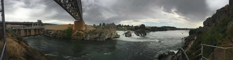
    <title type="html"><![CDATA[The American Falls Dam and Moving a Town]]></title>
    <summary type="html"><![CDATA[<p><strong><em>Underneath this massive reservoir lies the remains of the original town of American Falls.  Located in the best spot for a dam, the entire town had to be moved by cart uphill.  The cement grain silo deemed too difficult to move can still be seen poking out of the dam, and during an extremely low tide, you can walk on the old sidewalks where the city used to be.</em></strong></p><img src="https://www.intermountainhistories.org/files/fullsize/66c6dffe0a8292ec8c6e28060087c6d2.jpg" alt="The American Falls Dam Today" /><br/><p>The idea for the American Falls dam began after the success of the nearby Minidoka Dam led to better farmland and increased population.  In 1908, limited testing of a dam site began, and a decade later, in 1918, geological investigations began that led to the proposal of a dam in 1919.  This proposal presented a controversial issue, as it claimed that the best place for a dam and subsequent reservoir would be right where the town was located.  The authors of the proposal called for the relocation of a large section of American falls, a massive undertaking for a city that was starving from the falling crop prices of the post WW1 era.  Deliberations on both the federal and local level took years to conclude that the dam was necessary and to finally begin the process of moving.</p><p>The Bureau of Reclamation purchased many of the properties that would soon be flooded by the dam, and helped to clear the sagebrush to make new properties for these relocated homeowners.  They would eventually buy 329 properties in the area, while some homeowners decided to keep their claim on the land soon to be flooded.  However, by the end of 1921, the head of the Reclamation Service decided that this project was too costly and ordered it ended.  This alarmed many local farmers, who depended on dams and irrigation for water.  A group of local businesspeople and farmers raised enough money to cover the additional costs and petitioned  the Bureau to resume construction on the dam.  With half of the financial cost covered by the local community, the head of the Bureau of Reclamation acquiesced and resumed planning to move the city.</p><p>In 1925, construction began.  Old power lines and railroads had to be relocated around the dam, and the monumental task of moving the entire city had to be undertaken.  Most of the buildings in the city were moved by horses pulling large wheeled carts.  Famously, one particular Sunday, the St. John Lutheran Church was in transit and several worshipers attended their service in the church while it was on wheels.  By the end of 1925, all the buildings and markings from the former town site had been moved, with some exceptions.  All that remained were a few foundations, some sidewalks, and the giant concrete grain silo that was deemed too difficult to move.  The dam was finished in 1926, and local banks began opening up and expanding services, hopeful for the economic boost that this dam would bring.</p><p>The dam held more than 1.7 acre-feet of water and stretched for miles along the Snake river.  However, by 1973, it became evident that weathering and wear on the dam necessitated complete replacement of the structure.  The new dam, finished in 1978, was built downstream of the old dam, and actually lowered the amount of water that could be held.  Today, it supplies thousands of farms with water.  The cement grain silo can still be seen from the dam, as well as the old powerhouse.  This building was built two decades before the dam was made, utilizing the natural waterfall to generate power, which was sent via power lines to Pocatello.  The generator that was originally installed is still located within the dilapidated building, though it is impossible to reach.</p><p><em><strong><a href="https://www.intermountainhistories.org/items/show/77">For more (including 4 images) view the original article</a></strong></em></p>]]></summary>
    <published>2017-08-11T11:01:50+00:00</published>
    <updated>2026-04-17T19:31:59+00:00</updated>
    <link rel="alternate" type="text/html" href="https://www.intermountainhistories.org/items/show/77"/>
    <id>https://www.intermountainhistories.org/items/show/77</id>
    <author>
      <name>Josh Franzen, Brigham Young University</name>
    </author>
  </entry>
</feed>