<?xml version="1.0" encoding="UTF-8"?>
<feed xmlns="http://www.w3.org/2005/Atom">
  <title type="text">Intermountain Histories</title>
  <updated>2026-04-17T19:32:17+00:00</updated>
  <generator uri="http://framework.zend.com" version="1.12.20">Zend_Feed_Writer</generator>
  <link rel="alternate" type="text/html" href="https://www.intermountainhistories.org/"/>
  <link rel="self" type="application/atom+xml" href="https://www.intermountainhistories.org/items/browse?output=rss2"/>
  <id>https://www.intermountainhistories.org/</id>
  <author>
    <name>Intermountain Histories</name>
    <uri>https://www.intermountainhistories.org</uri>
  </author>
  <link rel="hub" href="https://pubsubhubbub.appspot.com/"/>
  <entry>
    <title type="html"><![CDATA[City National Bank of Boise]]></title>
    <summary type="html"><![CDATA[<p><strong><em>Opened in 1886, the Boise City National Bank quickly became one of the largest financial houses in Idaho and the Pacific Northwest, operating for a total of forty-six years.</em></strong></p><img src="https://www.intermountainhistories.org/files/fullsize/b717659bdc02604d2951ecfeaba1dac4.jpg" alt="Boise City National Bank" /><br/><p><span style="font-weight:400;">In 1886 Boise had a single national bank and Idaho’s growing mining and agricultural production offered conditions for another financial house. Alfred Eoff, a freelance economic agent operating across the American West since the 1860s, took advantage of this opportunity. Encouraged by Wells Fargo & Company treasurer Henry Wadsworth to seize the opportunity, Eoff established Boise City National Bank in 1886. Situated near Main Street and Capitol Boulevard, it was established as a competitor to the First National Bank of Idaho. Wadsworth acted as City National’s president while Eoff became its cashier, becoming part of Wells Fargo’s growing presence in the American West.</span>
<span style="font-weight:400;">Wadsworth’s recommendations proved sound. By 1890, City National Bank’s portfolio included over $620,000 in financial assets, with $65,000 held in securities alone. Idaho’s population boom increased City National’s business, requiring a larger building as the initial bank became too small to house its customers and resources, including cash, deeds, or precious metals. This led City National Bank’s board to construct a three-story building designed by local architect James King that could house both the bank and rentable commercial and office space. This new structure housed not only the bank but also the United States Marshals’ and Surveyor’s Offices as well as Idaho’s federal district court after its completion in 1892.</span>
<span style="font-weight:400;">Despite the 1890s economic downturn, City National’s portfolio continually increased, with total assets totaling $870,000 by 1900. Continued growth led to the addition of a fourth story commercial club in 1904 and renovations in 1913, all designed by John Tourtellotte & Company who also planned Idaho’s State Capitol. The commercial club catered to its patrons, who likely consisted of influential stockmen, farmers, and investors, offering amenities such as a dining district, billiards parlor, cardroom, lounge, writing room, and a library. </span>
<span style="font-weight:400;">By 1905, Wadsworth retired and Frank R. Coffin became City National’s new president. Coffin, previously lured west from Indiana, first settled in California as a tinsmith and later became a gold miner in Idaho’s 1860 gold strike. He served as Idaho’s first state treasurer from 1891-93, treasurer of the Artesian Hot and Cold Power Company, one of the state's leading utility corporations, and president of the Boise Clearinghouse Association, a local financial institution. Serving as president until he died in 1920, Coffin further expanded City National’s reach until it became Idaho's second-largest national bank, with $1.6 million in total assets.</span>
<span style="font-weight:400;">By 1932, during the strain of the Great Depression, City National voluntarily closed, citing depleted reserves. It argued that closure was the best option for depositors, with the remaining $2.5 million in accounts distributed among its clients. After its closure, various owners occupied the bank building, including the Idaho Building and Loan Association and the J. R. Simplot Company, one of Idaho’s largest corporations. Today it is owned by Rocky Mountain Management, and houses many offices and commercial businesses.</span></p><p><em><strong><a href="https://www.intermountainhistories.org/items/show/796">For more (including 7 images) view the original article</a></strong></em></p>]]></summary>
    <published>2024-03-20T19:44:45+00:00</published>
    <updated>2026-04-17T19:32:17+00:00</updated>
    <link rel="alternate" type="text/html" href="https://www.intermountainhistories.org/items/show/796"/>
    <id>https://www.intermountainhistories.org/items/show/796</id>
    <author>
      <name>William R. Batson, Northern Arizona University</name>
    </author>
  </entry>
  <entry>
    <title type="html"><![CDATA[Pleasant Grove Canning Company]]></title>
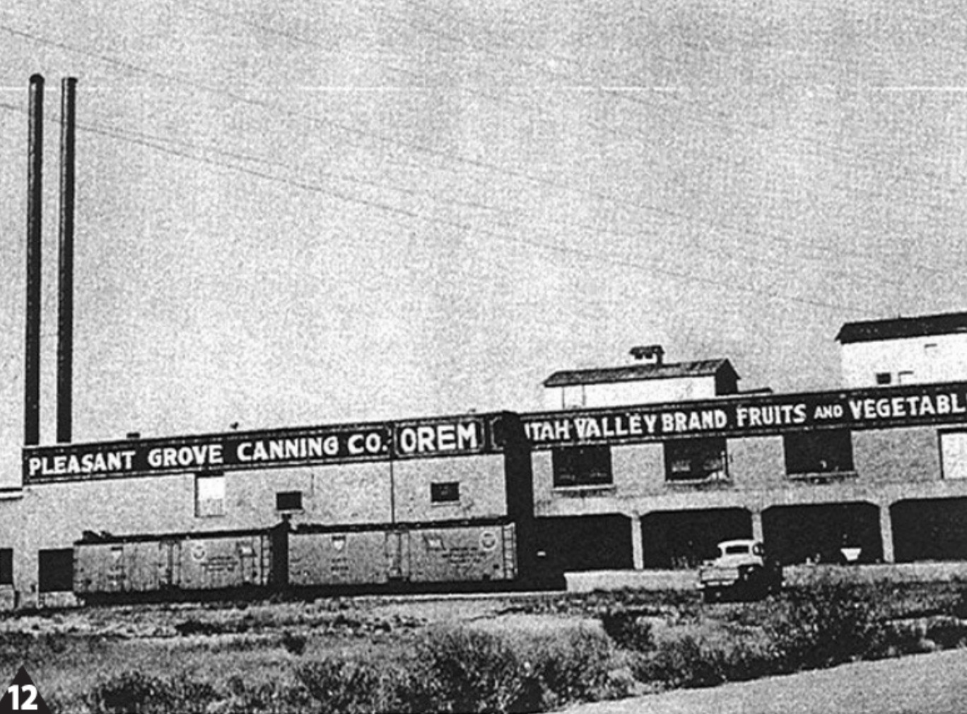
    <summary type="html"><![CDATA[<p><strong><em>Although no longer standing, the Pleasant Grove Canning Company was once a thriving business, canning large quantities of locally-grown produce and distributing it to many places around the country.</em></strong></p><img src="https://www.intermountainhistories.org/files/fullsize/00b1f46b83a87cfaed7060d882876abc.jpg" alt="Pleasant Grove Canning Company" /><br/><p><span style="font-weight:400;">The Pleasant Grove Canning Company, established in 1919 in Orem, Utah, marked a significant milestone as the town’s inaugural major industry. The canning industry had been growing in the United States for about 50 years before the Pleasant Grove Canning Company was created. By the time it opened, the preservation of produce through canning had been perfected. In the 1930s, during the Great Depression, there was little industry in Utah County, but the canning company took in produce from local farmers and farmers of the Provo Bench, canning, among other things, 75,000 cases of tomato paste. The company sold the tomato paste to the Campbell Soup Company.  </span>
<span style="font-weight:400;">The canning company underwent substantial changes in subsequent years as the industry in the state evolved.  In 1960, the Pleasant Grove Canning Company merged with Ogden’s Utah Canning Company and it became known as the Orem Plant of Utah Packers. Eventually, the decision was made to sell the company. In 1972, the company was sold to Booth Distributing Inc. and they used the building as a warehouse. </span>
<span style="font-weight:400;">Over the ensuing decades, the building was sold multiple times to different owners. In 1992, the once-thriving structure had fallen into disrepair and deemed a hazard by the city of Orem. Consequently, in 1993, the building was demolished, leaving behind only memories and a historic marker commemorating the site of the former Orem landmark. </span></p><p><em><strong><a href="https://www.intermountainhistories.org/items/show/785">For more (including 3 images) view the original article</a></strong></em></p>]]></summary>
    <published>2024-02-26T20:24:10+00:00</published>
    <updated>2026-04-17T19:32:17+00:00</updated>
    <link rel="alternate" type="text/html" href="https://www.intermountainhistories.org/items/show/785"/>
    <id>https://www.intermountainhistories.org/items/show/785</id>
    <author>
      <name>Trevor Sites, Brigham Young University</name>
    </author>
  </entry>
  <entry>
    <title type="html"><![CDATA[State Capitol Rotunda Murals: Salt Lake City, Utah]]></title>
    <summary type="html"><![CDATA[<p><strong><em>Utah’s State Capitol building features several artworks in its interior. Four large murals covering the Capitol Rotunda completed in 1935 particularly display the hopeful imagery typically found in art funded by New Deal-era projects.   </em></strong></p><img src="https://www.intermountainhistories.org/files/fullsize/8354ef98e35f8f660395b21e7783d729.jpg" alt="State Capitol Dome" /><br/><p><p style="font-weight:400;">The Utah Capitol’s ornate rotunda includes twelve murals that the Public Works of Art Project funded during the New Deal era. The pieces fill the dome and the spaces between the rotunda’s arches. Painted along the dome’s base, four illustrations display scenes from Utah’s pioneer settlement history, including: <em>Father Escalante Discovers Utah Lake – 1776</em>, <em>Peter Skene Ogden at Ogden River – 1828, Fremont First Sees Great Salt Lake – 1843</em>, and <em>Brigham Young and Pioneers Entering the Valley</em>. Prominent architect Richard K.A. Kletting, known for creating several Utah buildings, completed the Capitol in 1915 after winning a competition. Inspired by Greek and Roman architecture, Kletting designed the Capitol in the Corinthian style, seen through features such as its distinct exterior columns. With its large scale, Utah marble, and commanding city view, the building’s construction cost a grand $2,739,529.
<p style="font-weight:400;">Lee Greene Richards led the mural project, while Henry Rasmussen, Ranch S. Kimball, and Gordon Cope assisted him, with Waldo Midgely creating the murals’ borders. Richards grew up in Salt Lake City in an artistic family. He studied under J.T. Harwood in Salt Lake City, and at Paris’s <em>Académie Julian</em> and <em>École des Beaux-Arts</em>. While visiting England on a mission for The Church of Jesus Christ of Latter-day Saints, Richards developed a passion for portraiture, although he also became a popular muralist who captured Utah’s settler history in the rotunda murals. The Capitol rotunda’s murals opened in 1935 with ceremonies headed by former Utah Governor, Henry H. Blood.
<p style="font-weight:400;">The muralists conducted lengthy research to ensure that their chosen depictions were significant and accurately portrayed. While researching <em>Peter Skene Ogden at Ogden River –1828</em>, for example, Richards ensured that he depicted period-accurate weapons. In the murals including Brigham Young, however, Richards decided to artistically represent the Salt Lake City founder with his more recognizable beard, despite pioneer depictions from this period showing that Young was clean-shaven.
<p style="font-weight:400;"><em>Father Escalante Discovers Salt Lake – 1776,</em> depicts the Spanish expedition of Atanasio Domínguez and Silvestre Vélez de Escalante accompanied by a small group and one of three Ute people who guided them. Flanked by the area’s foliage, the background exhibits the scenic waters of the Great Salt Lake. In <em>Peter Skene Ogden at Ogden River – 1828</em>, Ogden and his company are in the vividly colored Ogden Valley using weapons like the Hawken rifle, the preferred weapon of choice along the western frontier. <em>Fremont First Sees Great Salt Lake –1843, </em>features John. C. Fremont and his party overlooking the lake’s expanse, positioned in an adventurous pose overlooking the scene. <em>Brigham Young and Pioneers Entering the Valley, </em><span>focuses </span><span>on Brigham young and his distinctive beard standing proudly as he reaches the Salt Lake Valley, joined by pioneers, cattle, and covered wagons</span>.
<p style="font-weight:400;">Examining these murals reveals the aims of the New Deal-era art projects in not only employing artists but also in creating a western American artistic identity. Indeed, the Public Works of Art Project-funded murals did not typically illustrate the Great Depression’s despair. Conversely, muralists like Richards chose to focus on themes of a settling, pioneering past. In choosing to depict scenes of Utah’s pioneer settlement, then, this optimistic vision guided Richards and his co-painters.<span>  </span></p><p><em><strong><a href="https://www.intermountainhistories.org/items/show/717">For more (including 4 images) view the original article</a></strong></em></p>]]></summary>
    <published>2023-03-01T18:13:30+00:00</published>
    <updated>2026-04-17T19:32:15+00:00</updated>
    <link rel="alternate" type="text/html" href="https://www.intermountainhistories.org/items/show/717"/>
    <id>https://www.intermountainhistories.org/items/show/717</id>
    <author>
      <name>Lindsey Cillis, Northern Arizona University</name>
    </author>
  </entry>
  <entry>
    <title type="html"><![CDATA[A Typical Western Town Mural: Helper, Utah]]></title>
    <summary type="html"><![CDATA[<p><strong><em><p style="font-weight:400;">Jenne Magafan painted <em>A Typical Western Town</em> from 1939-1941 under the Treasury Section of Fine Arts, a New Deal project that aimed to employ artists and craft an American arts culture. Magafan installed the painting in the Helper, Utah, Main Post Office, where visitors can still see it today.  </em></strong></p><img src="https://www.intermountainhistories.org/files/fullsize/b4ec8a9d622b6e0ef2ea18561a4bf3a2.jpg" alt="A Typical Western Town" /><br/><p><p style="font-weight:400;">In 1941, New Deal-era artist Jenne Magafan of Colorado completed her mural, <em>A</em><em> Typical Western Town</em>, in the Helper, Utah, Main Post Office. The post office building opened in 1938 and was placed by researchers on the National Register of Historic Places in 1989. With its initial installment, <em>A Typical Western Town</em> was the first post office mural that Utah received with funding from the Section of Fine Arts.
<p style="font-weight:400;">Magafan won the chance to install the oil-on-canvas mural through the Forty-Eight State competition as a part of the Treasury Section of Fine Arts. A well-known painter of the New Deal era who studied in a variety of institutions like the Colorado Springs Fine Art Center, Magafan practiced art with the mentorship of artists including Frank Mechau. The Section of Fine arts also commissioned Magafan for Post Office murals in Anson, Texas, and Glenwood Springs, Colorado. After completing the Helper mural, Magafan and her twin sister and fellow artist, Ethel, hung the painting over the postmaster’s office door.<span>   </span>
<p style="font-weight:400;">Magafan reflects the later nineteenth-century commotion of Helper’s industrial history in her mural riddled with motion. Helper, located in central Utah, was uniquely named after the additional locomotives that trains needed to ascend Soldier Summit, located between Helper and Salt Lake City, Utah. Helper once bustled as an activity center for many surrounding coal mining towns. Indeed, the history of coal mining in Carbon County is significant as it was crucial to the state’s economic development. Helper especially transformed into an economic hub after the Denver and Rio Grande Western Railroad’s completed its Castle Valley branch in 1883. Geologists discovered rich coal deposits in nearby Sunnyside along the path to Soldier Summit by Price Canyon, further cementing Carbon County as the coal mining center of Utah.
<p style="font-weight:400;">The five feet by twelve feet mural depicts a usual western town, likely during the bustling heights of Carbon County’s coal industry during the later nineteenth-century. In the central foreground, two men on horseback come to a stop as a curious dog barks at them. To the right, a “Blacksmith” sign stands above the shop’s worker, who appears to be repairing a wagon wheel. The left side includes a group of people conversing and a woman as she approaches a post office and grocery store. A saloon is placed next to the office. The background includes a wide blue sky. The focus is dedicated to the bustling and optimistic happenings of the town. Unlike other typical TSFA murals, <em>A Typical Western Town</em> does not feature specific natural landscapes. Rather, the lively, populated town that the work exhibits could reflect the thriving industrial history of Helper.<span>  </span>

</p><p><em><strong><a href="https://www.intermountainhistories.org/items/show/716">For more (including 4 images) view the original article</a></strong></em></p>]]></summary>
    <published>2023-02-28T18:05:13+00:00</published>
    <updated>2026-04-17T19:32:15+00:00</updated>
    <link rel="alternate" type="text/html" href="https://www.intermountainhistories.org/items/show/716"/>
    <id>https://www.intermountainhistories.org/items/show/716</id>
    <author>
      <name>Lindsey Cillis, Northern Arizona University</name>
    </author>
  </entry>
  <entry>
    <title type="html"><![CDATA[The Arrival Celebration and The Round-Up Murals: Blackfoot, Idaho]]></title>
    <summary type="html"><![CDATA[<p><strong><em>Andrew Standing Soldier completed the expansive Blackfoot Main Post Office murals in 1939 at the age of twenty-two. Covering nearly every office wall, the murals depict scenes of the Shoshone-Bannock peoples and their lives in Idaho’s Eastern Snake River Plain.  </em></strong></p><img src="https://www.intermountainhistories.org/files/fullsize/b132395541509c3a7b7c56f12a0d2633.jpg" alt="Post Office Mural" /><br/><p><p style="font-weight:400;">Andrew Standing Soldier, a Sioux artist of the Oglala Lakota Nation, completed <em>the </em><em>Arrival Celebration</em> and <em>The Round-Up</em> when he was twenty-two, installing the murals in Blackfoot, Idaho’s Main Post Office. Gilbert Stanley Underwood constructed the Blackfoot MPO in 1936 in the Art Deco style, seen specifically through details such as the foliage motif that decorates the building’s exterior columns. When researchers placed the building onto the National Register of Historic Places in 1989, it was the sole federally-constructed post office in Idaho built in the Art Deco style. The building continues to operate as a post office today.
<p style="font-weight:400;">Andrew Standing Soldier was born in 1917 on South Dakota’s Pine Ridge Reservation. He was taught to draw by his father, Martin Standing Soldier. During the 1930s, he studied art under the Swedish muralist Olle Nordmark, a Pine Ridge artist-in-residence who was known for his mural work in New York. Nordmark went on to supervise Standing Soldier during the creation of the MPO murals. With his individualistic, western-focused style and well-drawn horses, Standing Soldier painted the post office murals through a government commission after he submitted sketches of his ideas.
<p style="font-weight:400;">Standing Soldier painted the five-panel <em>Arrival Celebration</em> and <em>Round-Up</em> with a realistic and Regionalist style under the Treasury Section of Fine Arts (TSFA), as a part of a six-mural project in Idaho funded by New Deal-era projects. The works cover all of the post office’s walls excluding the front wall and contains scenes based on life sketches depicting the everyday life of the Shoshone-Bannock peoples who live on the Fort Hall, Idaho, reservation. Their ancestral lands make up present day Idaho, Montana, Nevada, Oregon, Utah, Wyoming, and parts of Canada.
<p style="font-weight:400;"><em>The Arrival Celebration</em> and <em>The Round-Up</em> depict the western life of the Shoshone-Bannock peoples as they go about their day. In the background, he painted the distinct scenery of the vast Eastern Snake River Plain and the feeding ground that it provided for cattle. Along the mural’s wide expanse, the artist included scenes such as families travelling with horse-drawn wagons, people conversing on horseback, preparing covered wagons, cutting wood, and making meals with cattle roaming in the background. Standing Soldier also filled the scene with depictions of the traditional tipi dwellings of the tribes. <em>The Round-Up</em> portion of the mural shows a group of people as they work to rope and brand cattle.
<p style="font-weight:400;">His murals reflect the aims of the Treasury Section of Fine Arts in employing artists as well as establishing a western identity in art that everyday people could see for free in their day-to-day lives as they ran errands at the post office. Indeed, most New Deal-funded murals did not portray the Great Depression’s troubles, but rather displayed regional scenes of optimistic imagery and scenes of conviviality like the group cooking scene portrayed in Standing Soldier’s work.

</p><p><em><strong><a href="https://www.intermountainhistories.org/items/show/715">For more (including 4 images) view the original article</a></strong></em></p>]]></summary>
    <published>2023-02-27T23:04:14+00:00</published>
    <updated>2026-04-17T19:32:15+00:00</updated>
    <link rel="alternate" type="text/html" href="https://www.intermountainhistories.org/items/show/715"/>
    <id>https://www.intermountainhistories.org/items/show/715</id>
    <author>
      <name>Lindsey Cillis, Northern Arizona University </name>
    </author>
  </entry>
  <entry>
    <title type="html"><![CDATA[The Harvest Mural: Grand Junction, Colorado]]></title>
    <summary type="html"><![CDATA[<p><strong><em>Louise Emerson Ronnebeck’s The Harvest, completed in 1940, is representative of the Regionalist-style Treasury Section of Fine Arts-funded work with its depiction of a storied local industry and a significant regional history.    </em></strong></p><img src="https://www.intermountainhistories.org/files/fullsize/6309826ace319719f4fd1829db78a770.jpg" alt="The Harvest by Louise Emerson Ronnebeck" /><br/><p><p style="font-weight:400;">Louise Emerson Ronnebeck’s <em>The</em> <em>Harvest</em> is a Regionalist-style mural found in James A. Wetmore’s 1918-designed Wayne N. Aspinall Federal Building United States Courthouse in Grand Junction, Colorado. Completed in 1940 under the Treasury Section of Fine Arts, the mural hangs in the building’s post office today.
<p style="font-weight:400;">Art programs like the The Treasury Section of Fine Arts (TSFA) allowed for greater opportunities for women artists to work. In the typical process of creating TSFA murals, Ronnebeck, a prominent artist during the New Deal era, won the opportunity to paint <em>The </em><em>Harvest</em> through an anonymous contest after she submitted a sample sketch. In 1940, when leading architect Louis A. Simon expanded the Wayne N. Aspinall Federal Building, Ronnebeck installed <em>The Harvest</em> to adorn the postmaster’s office door pediment with its distinct V-shaped bottom.<span>  </span>
<p style="font-weight:400;">Ronnebeck’s work prominently represents the history of the Ute people’s forced removal from Colorado throughout the nineteenth century. Before the 1860s, Ute people had lived in southwest Colorado for centuries and had established seasonal hunting grounds in the area. They also faced minimal encroachment from European and American settlers prior to the 1860s, until mineral interest drew more into the area. The United States government desired to increase land possession in the region. As such, they forced all seven Ute bands into a single reservation. Still, settlers intruded into reservation boundaries seeking minerals, further increasing hostility between the groups. Events like the Meeker Incident, in which a Ute group killed Agent Nathan Meeker, ten men, and took five others hostage, represented the hostility’s heights. The event culminated in an us-or-them sentiment. Settlers refused to leave, and by 1881, efforts to force the last Ute bands away from Colorado succeeded, with Southern Utes remaining within a sparse boundary.<span> </span>
<p style="font-weight:400;">As six million acres once inhabited by the Utes became available for settlement, the Mesa County region attracted settlers who established local industries like orcharding, depicted through <em>The Harvest’s </em>Regionalist-style. Indeed, peaches make up more than seventy-five percent of Colorado’s fruit production today. Festivals such as 1909’s Peach Day display the fruit’s significant settler history in the area, dating back to the development of irrigation systems in the Grand Valley during the late 1800s and early 1900s. Numerous peach orchard establishments led to the Mesa area’s status as a highly concentrated peach district.
<p style="font-weight:400;"><em>The Harvest</em> depicts a couple in the foreground harvesting a peach crop. On the couple’s sides, Ronnebeck represents episodes of western settler and Native history. On the left, settlers move into the area with their horses. On the right, Ute people leave as settlers force them out into the painting’s background featuring Grand Junction’s mesas. As such, <em>The</em> <em>Harvest</em> is characteristic of New Deal-era TSFA murals. Most of them did not choose to focus on the Great Depression or generalized art focusing on universal features. Instead, paintings like <em>The</em> <em>Harvest</em> chose to focus on thriving local industries and impactful regional histories.

</p><p><em><strong><a href="https://www.intermountainhistories.org/items/show/714">For more (including 3 images) view the original article</a></strong></em></p>]]></summary>
    <published>2023-02-27T21:38:33+00:00</published>
    <updated>2026-04-17T19:32:15+00:00</updated>
    <link rel="alternate" type="text/html" href="https://www.intermountainhistories.org/items/show/714"/>
    <id>https://www.intermountainhistories.org/items/show/714</id>
    <author>
      <name>Lindsey Cillis, Northern Arizona University</name>
    </author>
  </entry>
  <entry>
    <title type="html"><![CDATA[Cattle Round-Up Mural: Winnemucca, Nevada]]></title>
    <summary type="html"><![CDATA[<p><strong><em>The Treasury Section of Fine Arts financed Polly Duncan to paint Cattle Round-Up in the Winnemucca Main Post Office as a part of its 1940 expansion plan. It is a model example of the regionally focused murals completed as a part of the New Deal’s Federal Art Project, and can now be found in the new Winnemucca Post Office on Hanson Street.   </em></strong></p><img src="https://www.intermountainhistories.org/files/fullsize/fcf3a160fc91d54cd57acb409f85430a.jpg" alt="&quot;Cattle Round-Up&quot; by Polly Duncan" /><br/><p><span style="font-weight:400;">Polly Duncan’s </span><i><span style="font-weight:400;">Cattle Round-Up</span></i><span style="font-weight:400;">, added to the Winnemucca Main Post Office as a part of its </span><span style="font-weight:400;">1940 renovation project, provides a model example of the New Deal’s Federal Art Project and its goals. Constructed in 1921 by James A. Wetmore, the Neo-Classical Winnemucca Main Post Office was the original home of </span><i><span style="font-weight:400;">Cattle Round-Up</span></i><span style="font-weight:400;"> and was the first federally constructed post office in the northern Nevada town. Today, </span><i><span style="font-weight:400;">Cattle Round-Up</span></i><span style="font-weight:400;"> can be viewed in the city’s new post office building located on Hanson Street.     </span>
<span style="font-weight:400;">Polly Duncan, a Denver-based artist, completed the mural in 1942 under the Federal Works Agency Section of Fine Arts. Duncan worked in the 1930s under the mentorship of established Coloradan muralist Frank Mechau, who highlighted the beauty of natural western landscapes in his works. Accompanied by a collective of other young artists, she lived in a cottage located in Redstone, Colorado. She assisted Mechau on his own artistic endeavors during the winter of 1936. </span>
<span style="font-weight:400;">Only one of three WPA murals in Nevada, the oil-on-canvas work depicts several cowboys in the foreground as they herd Hereford cows into a shed. In the background, the rest of the herd can be seen against the backdrop of the Nevada landscape with its expansive fields, reflecting the area’s significant local history in cattle ranching. </span>
<span style="font-weight:400;">Emigrants first brought the cattle into the area during the 1840s on the Applegate and California trails, where groups founded cattle ranches in the 1850s. The vastness of the Humboldt River Valley landscape, with plenty of space for grazing, made the area a desirable location to raise cattle, and by the 1870s, the industry was thriving with the help of the Central Pacific Railroad’s shipping capabilities. The Hereford cattle depicted in Duncan’s mural were a particularly popular choice of livestock in 1890s Winnemucca for their faster maturation, which in turn enabled greater profits.   </span>
<span style="font-weight:400;">The mural is a common example of the type of artwork produced under the Section of Fine </span><span style="font-weight:400;">Arts-Federal Works Agency and represented the federal government’s goal to provide aid to local communities through employing artists to depict optimistic American images. Indeed, the New Deal-era murals did not typically portray the Great Depression’s difficulties or create generalized images of a geographic American identity. Rather, they often represented local communities. As such, the mural reflects the goals of building American cultural identity in the Intermountain West and democratizing American art as everyday people were able to interact with the image on their regular visits to the post office.  </span></p><p><em><strong><a href="https://www.intermountainhistories.org/items/show/713">For more (including 6 images) view the original article</a></strong></em></p>]]></summary>
    <published>2023-02-25T01:45:12+00:00</published>
    <updated>2026-04-17T19:32:15+00:00</updated>
    <link rel="alternate" type="text/html" href="https://www.intermountainhistories.org/items/show/713"/>
    <id>https://www.intermountainhistories.org/items/show/713</id>
    <author>
      <name>Lindsey Cillis, Northern Arizona University</name>
    </author>
  </entry>
  <entry>
    <title type="html"><![CDATA[The Hoover Dam]]></title>
    <summary type="html"><![CDATA[<p><strong><em>At the time of its completion, the Hoover Dam was the largest dam in the world. Today, it remains the largest dam of its type in the United States and provides invaluable water to the southwest. </em></strong></p><img src="https://www.intermountainhistories.org/files/fullsize/8ab0bafd443bffdcd7e8b050c0f3664d.jpg" alt="Hoover Dam and Lake Mead" /><br/><p><span style="font-weight:400;">Nestled in the Black Canyon, the Hoover Dam helps control the Colorado River’s flooding cycle that once devastated nearby communities. Construction started in 1931 and finished in 1935. 21,000 individuals worked on the monumental project and just under 100 individuals died from the dangerous working conditions. In order to authorize building the dam, the states of Colorado, Wyoming, Utah, New Mexico, Arizona, California, and Nevada had to decide how to divide water rights along the Colorado River between themselves and Mexico. Ultimately, the Hoover Dam is not just an engineering marvel of American ingenuity but also a display of states working in union to overcome a shared problem. </span>
<span style="font-weight:400;">Before the Public Works Administration could begin construction, they needed labor. Would-be construction laborers flocked to Las Vegas for the chance to work on the construction of the dam. The project took place during the Great Depression and, although it was authorized under Herbert Hoover’s presidency, was a symbol of the public works projects that President Franklin Roosevelt used to put Americans back to work. The project was not without risks and conflict. In August of 1931, the workers at the Hoover Dam went on strike. Their complaint was against unsafe working conditions. Individuals toiled in tunnels that could reach up to 140 degrees, which was made worse by Las Vegas’s heat. In July, the average high of the day hovered at about 106 degrees. There were also casualties from the unsafe conditions, such as workers falling from heights of up to 800 feet. Construction also kicked up dust and produced carbon monoxide. Both are dangerous, with carbon monoxide being potentially deadly. Despite these dangers, sufficient labor remained. There were enough workers that Boulder City was created in order to provide closer living quarters to the worksite. </span>
<span style="font-weight:400;">The spectacle of the enormous structure has drawn tourists since before it was even finished. Tourists began visiting the dam before its completion, leading the team to construct an observation deck in order to keep visitors away from the dangerous worksite. Today, around 7 million individuals visit the dam itself while around 10 million individuals visit the lake created by the dam, named Lake Mead. At the time it was the largest dam in the world, and while others have eclipsed it in size, in the United States it remains the tallest dam, and Lake Mead the largest lake created by a dam.</span></p><p><em><strong><a href="https://www.intermountainhistories.org/items/show/476">For more (including 5 images) view the original article</a></strong></em></p>]]></summary>
    <published>2021-09-10T23:44:11+00:00</published>
    <updated>2026-04-17T19:32:10+00:00</updated>
    <link rel="alternate" type="text/html" href="https://www.intermountainhistories.org/items/show/476"/>
    <id>https://www.intermountainhistories.org/items/show/476</id>
    <author>
      <name>Nikki Smith, Brigham Young University</name>
    </author>
  </entry>
  <entry>
    <title type="html"><![CDATA[The Rush Creek Point Fire Lookout and Fire Suppression <br />
]]></title>
    <summary type="html"><![CDATA[<p><strong><em>Rush Creek Point Fire Lookout is an abandoned fire lookout overlooking the Rush, Cabin, and Big Creek drainages in central Idaho’s Payette National Forest, built by the Civilian Conservation Corps (CCC) as part of the Forest Service’s fire suppression efforts.</p></strong></p><img src="https://www.intermountainhistories.org/files/fullsize/2f634c9d453524fbbca9cd296dfe52ac.jpg" alt="Rush Creek Point Fire Lookout " /><br/><p>The Rush Creek Point Fire Lookout is a small structure built in 1937 by the Civilian Conservation Corps to monitor fires from its vantage point straddled between the Big Creek and Rush Creek drainages. Fire lookouts were necessary due to the Forest Service’s 10:00 AM policy, which announced that forest fires should be put out by 10:00 AM on the day after they occurred. To make this feasible, the CCC built fire lookouts while the Forest Service strung telephone lines throughout the national forests for communication with the outside world. The surplus of labor during the Great Depression made this development possible with the government-sponsored work-relief programs of the New Deal, such as the CCC. </p><p>The aggressive fire-fighting policy of the Forest Service often proved impracticable in Idaho. Forest Service employee Elers Koch noted in his 1935 article “The Passing of the Lolo Trail,”  the failures of the firefighters to contain the conflagrations even under ideal conditions, suggesting that perhaps some of this difficulty originated from the buildup of fuels as a result of earlier fire suppression. Despite these early concerns, the Forest Service maintained the 10:00 AM policy until 1977, after which fires were addressed with individualized plans often including alternatives to suppression.</p><p>The 1980 Central Idaho Wilderness Act further reduced the necessity of the Rush Creek Point Fire Lookout by defining this portion of the Payette National Forest as part of the Frank Church-River of No Return Wilderness Area. This limited the fire suppression activities that the Forest Service was legally allowed to conduct, since in wilderness areas the use of motorized tools is prohibited. Furthermore, suppressing fire at all in wilderness is only questionably legal, since the act calls for wilderness “untrammeled” by man. Abandoned, the Rush Creek Point Fire Lookout has been out of service for many years, a relic of the Forest Service’s aggressive fire suppression. </p><p><em><strong><a href="https://www.intermountainhistories.org/items/show/302">For more (including 2 images) view the original article</a></strong></em></p>]]></summary>
    <published>2019-02-14T00:25:36+00:00</published>
    <updated>2026-04-17T19:32:05+00:00</updated>
    <link rel="alternate" type="text/html" href="https://www.intermountainhistories.org/items/show/302"/>
    <id>https://www.intermountainhistories.org/items/show/302</id>
    <author>
      <name>Everett Masterman, University of Idaho</name>
    </author>
  </entry>
  <entry>
    <title type="html"><![CDATA[El Monte Golf Course Clubhouse<br />
]]></title>
    <summary type="html"><![CDATA[<p><strong><em>The El Monte clubhouse was built with local and federal funds in 1934-1935. It is a fine example of bungalow style architecture used in a recreational setting.</p></strong></p><img src="https://www.intermountainhistories.org/files/fullsize/c765270ee01407d547d566a43a4faa10.jpg" alt="El Monte Clubhouse" /><br/><p>In 1928, with support from the Ogden Golf and Country Club, efforts were begun to secure a municipal golf course for Ogden. Led by florist Fred A. Huish (1866 – 1949) and other sports boosters, the course was to be located near El Monte Springs, at the mouth of Ogden Canyon. The Springs (formerly the Ogden Canyon Resort, 1895-1927) was a local resort which offered swimming, dancing, and picnicking activities. </p><p>El Monte Springs closed in 1932 because of the economic crisis of the Great Depression and the city considered leasing the facilities for use by the municipal golf players. However, the next year, the city opted to seek federal funds to build a clubhouse. Utah was one of the states most severely affected by the Great Depression.  As a consequence, it received substantial federal funding from New Deal programs. Perhaps the most prominent of these were building programs -- 233 public works buildings were constructed in the state of Utah.  Of these, 15 were constructed within Weber County.  The El Monte Golf Course Clubhouse was one of these projects.   </p><p>Funded by the Federal Emergency Relief Administration (FERA), the clubhouse project received $17,000, which was coupled with $5,500 from the city of Ogden.  Eber F. Piers (1889 – 1961) was hired as the architect. Piers came to Utah from Colorado in 1908 to work at an architecture firm.  In 1910, he opened his own firm and became a distinguished practitioner. Over the course of his career he designed over 300 buildings throughout the greater Ogden area.  Many of them, including the El Monte Clubhouse, are still in use today.</p><p>Most of the materials for construction, including the stonework on the exterior of the building, were taken from Ogden Canyon. The Clubhouse is a fairly simple, bungalow style building with a gable roof.  The exterior stonework continues inside to frame the large fireplace.  Most of the original decorations and paintings still adorn the walls.  It is a simple, yet elegant design that adds a certain beauty to the small golf course it accompanies.  Both the course and the clubhouse are still owned by the city of Ogden.</p><p><em><strong><a href="https://www.intermountainhistories.org/items/show/263">For more (including 4 images) view the original article</a></strong></em></p>]]></summary>
    <published>2019-01-26T04:21:27+00:00</published>
    <updated>2026-04-17T19:32:04+00:00</updated>
    <link rel="alternate" type="text/html" href="https://www.intermountainhistories.org/items/show/263"/>
    <id>https://www.intermountainhistories.org/items/show/263</id>
    <author>
      <name>Kiselya Plewe, Weber State University</name>
    </author>
  </entry>
  <entry>
    <title type="html"><![CDATA[The Indian New Deal and the Shoshone-Bannock Constitution]]></title>
    <summary type="html"><![CDATA[<p><strong><em>The Great Depression brought hard times to the Intermountain West but also provided an opportunity for Native Americans to change the existing state of affairs. An “Indian New Deal” brought the Shoshone-Bannock together and gave the opportunity for the establishment of an intertribal constitution on Fort Hall.  </em></strong></p><img src="https://www.intermountainhistories.org/files/fullsize/a08a303044adb45bd1bf80a21b5f3c90.jpg" alt="Appointed Indian Affairs Commissioner" /><br/><p>Two thousand miles away from the rich farmland and pastures of the Fort Hall Indian Reservation, the future of America’s native peoples was decided by politicians and sociologists in Washington, D.C. The new Commissioner of the Bureau of Indian Affairs, John Collier, hoped to implement policies that would strengthen tribal cultures rather than destroy them.  While President Franklin D. Roosevelt and Congress passed laws as part of the “New Deal,” Collier hoped for an “Indian New Deal” that would reverse the assault on Indian lands, rejuvenate tribal governments, preserve native languages, and revive tribal customs.  For the Shoshone-Bannock, these new policies meant a fundamental transformation of their whole reservation system. </p><p>Although Fort Hall may have been one of the more prosperous reservations in the United States, too many of its residents lived in or near poverty.  Tribal leader John Ballard lamented, “The things that [the government has] promised me in the past have not been fulfilled . . . [We] have been placed in a condition that is poor.”  To combat economic deprivation and provide Native Americans with more input into local decisions, John Collier spearheaded the effort to pass the 1934 Indian Reorganization Act (IRA). John Ballard agreed with Collier’s plan, as did eight of the other nine representatives from Fort Hall who met with government agents. Tribal leader Tom Cosgrove agreed, telling other Native Americans, “If we accept this bill we are going to help our Indians.”  Although Congress passed the IRA in June 1934, each tribe had to also separately approve the bill before adhering to its policies. When it came time for the Shoshone-Bannock to vote, 375 voted yes and only 31 voted no.   </p><p>The next great task for the Shoshone-Bannock was the implementation of the IRA. To do so, they needed to create a constitution that would satisfy Shoshone, Bannocks, ranchers, farmers, the federal government, the state government, and other factions on the reservation. On April 30, 1936, they finally succeeded in ratifying a constitution everyone could support. Although small disagreements continued to flare up after its ratification, the 1936 constitution held fast until today.  Among other things, the constitution established laws for the reservation, set requirements for tribal membership, and established a reservation government called the Fort Hall Business Council. This marked a new chapter for the history of Fort Hall.</p><p><em><strong><a href="https://www.intermountainhistories.org/items/show/204">For more (including 3 images) view the original article</a></strong></em></p>]]></summary>
    <published>2018-06-08T02:45:06+00:00</published>
    <updated>2026-04-17T19:32:02+00:00</updated>
    <link rel="alternate" type="text/html" href="https://www.intermountainhistories.org/items/show/204"/>
    <id>https://www.intermountainhistories.org/items/show/204</id>
    <author>
      <name>Natalie Larsen, Brigham Young University</name>
    </author>
  </entry>
  <entry>
    <title type="html"><![CDATA[&quot;Roosevelt&#039;s Tree Friends&quot; in Idaho]]></title>
    <summary type="html"><![CDATA[<p><strong><em>Franklin Delano Roosevelt’s 1933-1942 New Deal program, the Civilian Conservation Corps (CCC), provided rural areas and communities with economic stimulus as well as natural resource protection and preservation. While receiving an education and much-needed work, young men who enrolled with the CCC interacted with communities by furnishing isolated regions with recreational areas, accessibility, and protection from forest fire and disease.</em></strong></p><img src="https://www.intermountainhistories.org/files/fullsize/156b5a0fdf3df98861aa43298382ae7d.jpg" alt="CCC Firefighters" /><br/><p>Pres. Roosevelt aimed to employ more than 300,000 men in the CCC. Just two months after the program’s implementation, 1,200 worked in Payette National Forest camps such as Gallagher and Silver Creek. Roosevelt hoped their rural camps and labor would “add to present and future values of the nation’s natural resources.” Eventually, over 18,000 total men worked to do this in Idaho’s forests.</p><p>CCC camp impacted on nearby communities was significant. CCC workers constructed roads to make rural areas accessible and undertook beautification projects to bring order to a still-rustic region. Communities around the nation valued the program for its benefits; 85.1 percent of all letters written by community members and sent to the CCC director’s office contained positive opinions regarding the program. By 1941, Payette National Forest workers, then numbering over 4,500, completed 13 bridges, 134 buildings (mostly for the Forest Service), and 131 miles of road. CCC workers created recreational areas for nearby communities, many of which still exist. In 1939, for example, 170 workers from Gallagher camp worked at the 640-acre Warm Lake on the south side of the Payette National Forest. Enrollees developed a campground for Boy Scout use, built recreational buildings and constructed roads for public access to the area. CCC recreational projects helped launch a developing outdoor tourism industry in the Payette National Forest region, increasing the overall incomes of Idahoans. </p><p>While expanding recreational infrastructure, CCC workers preserved forests, fought fires, and planted trees in rural areas nationwide. Workers traversed the woods, sprayed pine beetle repellent and treated nearly two million acres of white pine for blister rust fungus in Idaho. In the Payette National Forest, fires were numerous. The summer of 1940 brought 90, and 600 CCC workers and nearby civilians toiled relentlessly to extinguish them. In the last week of August, workers helped quell 43 fires. The Flat Creek fire burned nearly 2,000 acres before firefighters controlled it, using trails built by CCC workers to import equipment. Workers also built fire watch towers and seeded barren areas. Between 1933 and 1941, Payette National Forest workers planted trees covering a sum total of 147 acres of land.</p><p>In between work projects, CCC enrollees received a general education, room and board and 30 dollars per month during their short stays. Much of each payment went to the workers’ struggling families. Workers frequently spent their remaining balance at local communities and often participated in recreational activities. In 1938, the Cascade townsfolk edged out Camp Gallagher 8-7 in a hyped inter-league baseball game. As seen in the newly formed sports leagues, composed of both townsfolk and CCC men, a cooperative attitude between workers and communities arose from the economic boost the CCC introduced.</p><p>The CCC in the Payette National Forest, the state of Idaho and rustic regions around the country provided not just an economic incentive for communities, but fostered a “civic generation.” Because of the program, forests are accessible and populated with trees the CCC planted and beautification projects its workers built. What newspapers called “the best New Deal program” went largely undisputed in the state of Idaho.</p><p><em><strong><a href="https://www.intermountainhistories.org/items/show/113">For more (including 5 images) view the original article</a></strong></em></p>]]></summary>
    <published>2018-01-31T19:37:14+00:00</published>
    <updated>2026-04-17T19:32:00+00:00</updated>
    <link rel="alternate" type="text/html" href="https://www.intermountainhistories.org/items/show/113"/>
    <id>https://www.intermountainhistories.org/items/show/113</id>
    <author>
      <name>Colton T. Clark, University of Idaho</name>
    </author>
  </entry>
  <entry>
    <title type="html"><![CDATA[The Horse Heaven CCC Camp: Life, Work, Masculinity and Education in the Northern Idaho Forest]]></title>
    <summary type="html"><![CDATA[<p><strong><em>Horse Heaven was one of the most remote CCC camps in North Idaho. It was constructed to be a ‘forest camp’ meaning that the majority of projects conducted by the workmen were related to forestry. </em></strong></p><img src="https://www.intermountainhistories.org/files/fullsize/ddaf8ea492186afe8db42a8777a96295.jpg" alt="Hill Side View" /><br/><p>The Civilian Conservation Corps (CCC) was one of the most popular of the 1930s New Deal programs, designed to employ young me, promote economic recovery by sending funds back to their families, and completing public works projects. The Horse Heaven camp, like many of the Pacific Northwest’s CCC camps, was dedicated to forestry and conservation projects. Its location near Enaville, Idaho in the Coeur d’Alene National Forest, allowed for easy access to areas in need of forestry projects. Men at this camp had loaded into cars and driven deep into the wilderness with 40,000 pounds of supplies to build the camp from the ground up. Due to the rugged trail they had to traverse, the thirty mile trip took them six hours by car. After their trek deep into the dense woodland, the caravan camped in a clear valley meadow that had been set aside for the CCC. They had to build their camp, number F-156, from nothing but the supplies they brought with them. Once they were finished one of the camp’s leaders, Major Clarke, called it one of the most beautiful in the area. Form their central location, the men of the camp were able to work on projects like road building and limiting the spread of blister rust, a deadly fungus, in the white pine population. More than just the effect on the local forest and the education of the men at the camps, the CCC was known for improving their outlook as well. </p><p>The Great Depression challenged concepts of masculinity of the time, but through camp activities the workmen of the CCC were able to rebuild their confidence. Men who had no work could not fulfill their prescribed roles as breadwinners, and those same men with little no money for food found themselves weakening physically. The CCC worked to effectively combat these doubts. It gave young men food and a steady job that allowed them to send money home to their families. The work they did was largely outdoors and very physical. When this was coupled with a steady nutritious diet, it allowed formerly weak and sickly men to regain their strength, further improving their self-image. Along with that, the residents of the CCC camps had the opportunity to educate themselves when not at work. Each camp in the CCC had a library and offered classes in diverse topics like public speaking and radio operation. Some classes would even be taught from visiting professors from nearby colleges. This gave the workmen at Horse Heaven camp the opportunity to exercise their minds as well as their bodies.</p><p>Horse Heaven camp was one of many CCC camps in North Idaho and across the United States. These camps served as the center of conservation efforts in their time, but their impact was far larger than just environmental. These camps served to preserve the self-respect of men who had been struggling with economic circumstance.  </p><p><em><strong><a href="https://www.intermountainhistories.org/items/show/105">For more (including 3 images) view the original article</a></strong></em></p>]]></summary>
    <published>2018-01-22T20:21:54+00:00</published>
    <updated>2026-04-17T19:31:59+00:00</updated>
    <link rel="alternate" type="text/html" href="https://www.intermountainhistories.org/items/show/105"/>
    <id>https://www.intermountainhistories.org/items/show/105</id>
    <author>
      <name>Nicholas C. Cousino, University of Idaho</name>
    </author>
  </entry>
</feed>