<?xml version="1.0" encoding="UTF-8"?>
<feed xmlns="http://www.w3.org/2005/Atom">
  <title type="text">Intermountain Histories</title>
  <updated>2026-08-18T15:52:34+00:00</updated>
  <generator uri="http://framework.zend.com" version="1.12.20">Zend_Feed_Writer</generator>
  <link rel="alternate" type="text/html" href="https://www.intermountainhistories.org/"/>
  <link rel="self" type="application/atom+xml" href="https://www.intermountainhistories.org/items/browse?output=rss2"/>
  <id>https://www.intermountainhistories.org/</id>
  <author>
    <name>Intermountain Histories</name>
    <uri>https://www.intermountainhistories.org</uri>
  </author>
  <link rel="hub" href="https://pubsubhubbub.appspot.com/"/>
  <entry>
    <title type="html"><![CDATA[Theodore Roosevelt and the Havasupai in the Grand Canyon: Story 2 of 8 of the President Theodore Roosevelt in the West Tour]]></title>
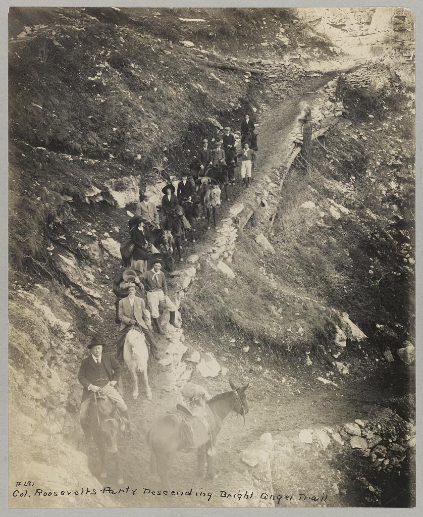
    <summary type="html"><![CDATA[<p><strong><em>President Theodore Roosevelt visits the Grand Canyon meeting the Havasupai Tribe. His efforts are making this landmark a National Park.</em></strong></p><img src="https://www.intermountainhistories.org/files/fullsize/81adde6a6a5c04daf97ec29b93d422ee.jpg" alt="Down a winding pathway, Theodore Roosevelt and others ride mules down Bright Angel Trail in the Grand Canyon" /><br/><p>Theodore Roosevelt traveled over 14,000 miles, visiting over 25 states, in the span of nine weeks in the early summer of 1903. His western tour was filled with speeches, commemorations, and his favorite thing to do: exploring the outdoors. His tours of Yosemite and Yellowstone are widely known, but in between them, he visited the Grand Canyon on May 6, 1903. He said, giving a speech, “In the Grand Canyon, Arizona has a natural wonder which, so far as I know, is absolutely unparalleled throughout the rest of the world.” Astounded, he said, “I shall not attempt to describe it, because I cannot. I could not choose words that would convey or that could convey to any outsider what that canyon is.” The majesty of Earth’s beauty there led him to explore more.
Riding a mule down Bright Angel Trail, he met two natives from the Havasupai tribe who lived in the Indian Garden with their families. For 1,000 years, the tribe lived in this region without outside contact, until Spanish priest Francisco Garces explored the area in 1776. As a result of the Santa Fe Railroad in the early 18th century, the Havasupai had increasingly more contact with other explorers and settlers. When Roosevelt and his regiment visited, he asked them to leave to make the canyon a National Park. To gain the status of a national park, all private development on the land would be illegal according to Congress. This resulted in the Havasupi’s relocation to a 518-acre reservation in Havasu Canyon instead.
Roosevelt was also concerned about the commercialization and exploitation of the land due to encroaching mining and timber interests. On June 8th, 1906, he signed the Antiquities Act, which authorized the president to “declare by public proclamation historic landmarks, historic and prehistoric structures, and other objects of historic or scientific interest that are situated upon the lands owned or controlled by the Government of the United States to be national monuments.” Subsequently, this act was used to establish the Grand Canyon National Monument on January 11th, 1908. It was made a National Park in 1919. Roosevelt Point and Trail were named in the President’s honor for the efforts he provided. A placard at Roosevelt Point reads another part from his speech advocating one request, “Leave it as it is. You can not improve on it. The ages have been at work on it, and man can only mar it. What you can do is to keep it for your children, your children's children, and for all who come after you, as one of the great sights which every American, if he can travel at all, should see.” Poetically, he wrote a letter to John Hay, former Secretary of State, summing up his experience on his Western tour and paying special attention to the Grand Canyon, “To me the most impressive piece of scenery I have ever looked at. I don’t exactly know what words to use in describing it. It is beautiful and terrible and unearthly. It made me feel as if I were gazing at a sunset of strange and awful splendor.” Today, almost 5 million tourists continue to explore this canyon that Roosevelt cared so profoundly to preserve.</p><p><em><strong><a href="https://www.intermountainhistories.org/items/show/924">For more (including 4 images) view the original article</a></strong></em></p>]]></summary>
    <published>2025-10-24T15:03:19+00:00</published>
    <updated>2026-08-18T15:52:34+00:00</updated>
    <link rel="alternate" type="text/html" href="https://www.intermountainhistories.org/items/show/924"/>
    <id>https://www.intermountainhistories.org/items/show/924</id>
    <author>
      <name>Jessika Cole, Brigham Young University</name>
    </author>
  </entry>
  <entry>
    <title type="html"><![CDATA[Bryce Canyon Lodge and Deluxe Cabins - Bryce Canyon National Park]]></title>
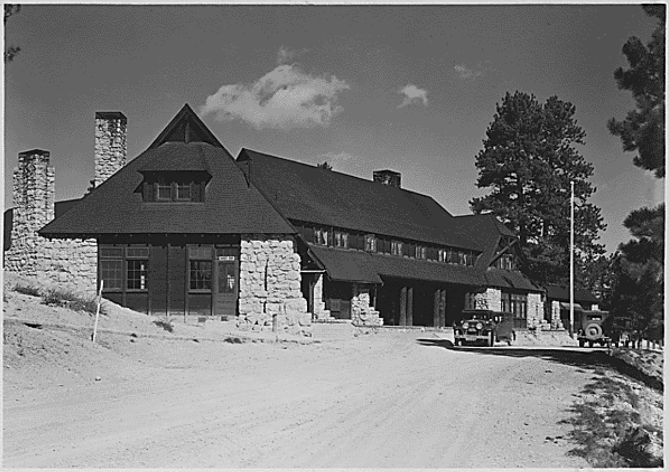
    <summary type="html"><![CDATA[<p><strong><em><span style="font-weight:400;">In 1923, the Union Pacific Railroad created the Utah Parks Company, which connected its rail line to attractions such as Zion National Park and the North Rim of Grand Canyon National Park. The Bryce Canyon Lodge and Deluxe Cabins linked Bryce Canyon State Park to this system of resorts in 1925. </span></em></strong></p><img src="https://www.intermountainhistories.org/files/fullsize/2d65ab73bf5bf337b81a40dba1d6d45e.jpg" alt="Bryce Canyon Lodge, c. 1929" /><br/><p><span style="font-weight:400;">In 1874, Bryce Canyon became part of a cattle ranch owned by Ebenezer Bryce. His ranch was unsuccessful, but automobile tourism revitalized the area when passable roads reached what is now Zion National Park in 1917. In 1921, Utah’s state legislature accepted a proposition from Park Service director Stephen Mather that protected Bryce Canyon as a state park. Utah made no attempt to develop the area for public use, but the Union Pacific Railroad spurred development in Bryce Canyon by creating the Utah Parks Company in 1923. This connected the Union Pacific’s Cedar City spur line to Bryce Canyon, the North Rim of Grand Canyon National Park, and Zion via bus lines. By establishing a network of parks and resorts, the Union Pacific aimed to compete with other successful railroad companies such as the Northern Pacific, Atchison-Topeka Santa Fe, and Great Northern. These companies had established successful tourist attractions at the South Rim of Grand Canyon, Yellowstone National Park, and Glacier National Park. As tourism brought in profit, road construction improved access to rural points of interest like Bryce Canyon. In 1924, Congress established Utah National Park, and the Utah Parks Company constructed Bryce Canyon Lodge and Deluxe Cabins in the same year to provide visitors with accommodations. Congress enlarged Utah National Park and renamed it Bryce Canyon in 1928. </span>
<span style="font-weight:400;">The Utah Parks Company enlisted Gilbert Stanley Underwood, one of the Union Pacific’s consulting architects, to design Bryce Canyon Lodge. Underwood’s designs are notable for their commitment to rustic architecture, which used natural materials and textures to blend a building with its natural surroundings. He utilized locally quarried stone and large, exposed wooden details throughout the structure, figuratively connecting the building to its location. After the company completed the original building in 1925, it added two new wings in 1926 to make room for an increasing number of visitors. The Utah Parks Company constructed fifteen deluxe guest cabins the following year in a pine grove near the main structure. Their design used rough stone and natural wood to imitate the design of Bryce Canyon Lodge. </span>
<span style="font-weight:400;">During the 1950s, the National Park Service renovated Bryce Canyon Lodge to make room for updated amenities. The hotel originally housed a barber shop, but the Park Service replaced it with a soda fountain. The Park Service also enlarged a road at the hotel’s front entrance to make room for larger vehicles, but the Park service expanded a plaza outside Bryce Canyon Lodge’s front entrance by removing the original bus lane in 1989. In 1985, the Park Service removed sixty-one of the lodge’s original sixty-seven standard cabins. The Sunrise Motel and Sunset Motel replaced them. In 1995, the National Register of Historic Places officially listed forty-two buildings in Bryce Canyon, including Bryce Canyon Lodge. This restricted future renovations, allowing the complex to retain most of its architectural significance. Today, Bryce Canyon Lodge operates as a historic hotel alongside five standard cabins and fifteen deluxe cabins. </span></p><p><em><strong><a href="https://www.intermountainhistories.org/items/show/843">For more (including 5 images) view the original article</a></strong></em></p>]]></summary>
    <published>2024-05-29T21:42:39+00:00</published>
    <updated>2026-04-17T19:32:19+00:00</updated>
    <link rel="alternate" type="text/html" href="https://www.intermountainhistories.org/items/show/843"/>
    <id>https://www.intermountainhistories.org/items/show/843</id>
    <author>
      <name>Kaylen Wilson, Northern Arizona University </name>
    </author>
  </entry>
  <entry>
    <title type="html"><![CDATA[El Tovar Hotel - Grand Canyon National Park ]]></title>
    <summary type="html"><![CDATA[<p><strong><em>In 1901, the Atchison-Topeka Santa Fe Railway constructed a spur line from Williams, Arizona, that provided access to the Grand Canyon’s South Rim. El Tovar soon followed, providing its guests with the region’s first luxury accommodations.</em></strong></p><img src="https://www.intermountainhistories.org/files/fullsize/4856f91fdf081f933e9854aa688f9055.jpg" alt="El Tovar’s east side, circa 1905" /><br/><p><span style="font-weight:400;">Before the Atchison-Topeka Santa Fe Railway reached Grand Canyon Village in 1901, only a few rudimentary hotels served the Grand Canyon’s South Rim. These establishments relied on a local stagecoach line, which operated between Flagstaff, Arizona and a ranch near the rim. Because the twenty-dollar journey took three days to complete, the railroad provided a more efficient way to reach the canyon, and its arrival shifted the center of activity at Grand Canyon Village away from Thurston’s stagecoach line. Fred Harvey, a hospitality company whose Harvey houses provided quality food and lodging to passengers on the Santa Fe Railway, constructed El Tovar near the railroad tracks to draw in train passengers. The hotel cost $250,000 to construct, providing the Grand Canyon’s first luxury lodgings. </span>
<span style="font-weight:400;">Opened in 1905, El Tovar hotel predated the Grand Canyon’s designation as a national monument in 1908 and a national park in 1919. As a national monument, the Grand Canyon received less funding and attention than established national parks like Yellowstone. However, as tourism increased, calls for the area to receive further protections intensified. Ford Harvey, who served as president of the Harvey company until 1928, routinely advocated for Grand Canyon’s national park status at conferences. Conservation efforts gained strength when Arizona became a state in 1912, but many Grand Canyon residents opposed the national park proposal due to concerns about land and mineral rights. Regardless, President Woodrow Wilson officially signed the bill that established Grand Canyon National Park on February 26, 1919, and the Harvey company secured a hospitality contract from the new National Park Service (created in 1916) in 1920.</span>
<span style="font-weight:400;">Architect Charles Whittlesey’s design for El Tovar used the rustic architectural style, which aimed to establish a connection between buildings and their environment. Whittlesey designed the log siding on the first floor to resemble the wall of a log cabin. Natural building materials like rough stone and logs appear throughout the building, reinforcing this style. Whittlesey combined these rustic features with the architecture of traditional luxury resorts, which catered to Victorian tastes and a desire for exotic destinations. Decorative wooden poles known as balusters, which mimic Swiss chalet architecture, enclose El Tovar’s porches and balconies. The design also includes a small round tower known as a turret, which echoes resort architecture. </span>
<span style="font-weight:400;">El Tovar originally featured luxurious amenities, including hot running water and electric lighting. In the 1950s, the Harvey company added a new cocktail lounge to the hotel’s dining area. A 1983 renovation exchanged the hotel’s sparse public restrooms with private facilities, added carpeting, replaced windows, and included a new heating system. For this reason, El Tovar currently houses seventy-nine rooms instead of the original ninety-five. In 1968, Hawaii-based hospitality company Amfac purchased the Harvey company and gained control of El Tovar. In the 1990s, Amfac created Xanterra Parks and Resorts to control its concessions at the Grand Canyon, and Xanterra still manages El Tovar today. </span></p><p><em><strong><a href="https://www.intermountainhistories.org/items/show/840">For more (including 6 images) view the original article</a></strong></em></p>]]></summary>
    <published>2024-05-29T20:25:01+00:00</published>
    <updated>2026-04-17T19:32:19+00:00</updated>
    <link rel="alternate" type="text/html" href="https://www.intermountainhistories.org/items/show/840"/>
    <id>https://www.intermountainhistories.org/items/show/840</id>
    <author>
      <name>Kaylen Wilson, Northern Arizona University </name>
    </author>
  </entry>
  <entry>
    <title type="html"><![CDATA[North Rim Lookout Tower]]></title>
    <summary type="html"><![CDATA[<p><strong><em>The North Rim Lookout Tower helped to protect the area of the Grand Canyon. One can still appreciate immaculate views of the Grand Canyon from high above northern Arizona’s ponderosa forests at the North Rim Lookout Tower which is available to hikers. </em></strong></p><img src="https://www.intermountainhistories.org/files/fullsize/163624658f254fa48626545cb65fa694.jpg" alt="Fire Lookout in the Grand Canyon" /><br/><p><p style="font-weight:400;">Following the Great Fire of 1910, which devastated much of the northern Rocky Mountains, the Forest Service prioritized wildfire suppression. By the mid-1910s, it constructed three small platforms along the Canyon’s edge to spot fires. The North Rim platform, constructed at Bright Angel Point, provided forest rangers and tourists with impeccable views of the forests which lined the Canyon.</p><p>As one of the natural wonders of the world, the Grand Canyon is widely considered one of America’s environmental gems. Federal attempts to preserve the Canyon date all the way back to the late nineteenth century, when the then Indiana Senator, Benjamin Harrison, proposed three bills in the 1880s to set aside the canyon as a national park.<span> </span>Though each of the bills failed, President Harrison eventually granted the Grand Canyon status as a Forest Reserve in the waning days of his presidency in 1893. After President Theodore Roosevelt visited the area in 1903, he granted the site status as a National Monument in 1908, <span>replacing Harrison’s reserve</span><span> </span>. The National Park Service wouldn’t be founded for another eight years, so the Monument fell under control of the fledgling US Forest Service.
<p style="font-weight:400;">The Grand Canyon gained status as a National Park in 1919. The Park Service continued the Forest Service’s policy of fire suppression, and in 1928, it replaced the platform with a seventy five-foot tall steel tower. Topped with a tiny observation cab, fire lookouts lived in a small cabin beneath the structure. Under contract, the Aeromotor Company constructed the Bright Angel Lookout Tower. Aerometer also designed and produced the iconic windmill water pumps which became a symbol of the American West during the late nineteenth and early twentieth centuries.
<p style="font-weight:400;">During the 1930s, the Civilian Conservation Corps (CCC) updated much of the North Rim’s infrastructure. This included moving the Bright Angel Lookout roughly fourteen miles away to the Park’s northern entrance. In 1933, the CCC renamed the structure the North Rim Lookout Tower.
<p style="font-weight:400;">From the late 1960s to the early 1970s, writer and environmentalist Edward Abbey spent four seasons working in the tower. Abbey’s time in the station inspired his book <em>Black Sun, </em>a novel which tells the story of a fire lookout in the Grand Canyon who falls in love with a tourist. When she goes missing, the lookout is blamed for her mysterious disappearance. In his book <em>Fire on the Rim</em>, Stephen Pyne references Abbey as the reason the Park ceased lookout tower operations. “Whether [Abbey] was even in the tower, no one could say. He was a writer, and the only smokes he reported were the ones in his novels… he was absent so often that he demonstrated that we did not need a lookout, because having [Abbey] in the tower was the same as having no one.” Ultimately, the Park opted for aerial fire spotting instead.
<p style="font-weight:400;">Though abandoned, North Rim Lookout Tower is still accessible. Hikers can reach the site via a short hike from the Park’s northern entrance toll booth.</p><p><em><strong><a href="https://www.intermountainhistories.org/items/show/709">For more (including 5 images) view the original article</a></strong></em></p>]]></summary>
    <published>2023-02-23T00:36:16+00:00</published>
    <updated>2026-04-17T19:32:15+00:00</updated>
    <link rel="alternate" type="text/html" href="https://www.intermountainhistories.org/items/show/709"/>
    <id>https://www.intermountainhistories.org/items/show/709</id>
    <author>
      <name>Tanner Hammarstrom, Northern Arizona University</name>
    </author>
  </entry>
  <entry>
    <title type="html"><![CDATA[Grand Canyon Depot]]></title>
    <summary type="html"><![CDATA[<p><strong><em>Take the Grand Canyon Railway to the historic train depot in Grand Canyon National Park and experience the unique architectural design of the only operating log depot in the United States.</em></strong></p><img src="https://www.intermountainhistories.org/files/fullsize/f9bfc58de0278251fc6045574c950f38.jpg" alt="The depot in 1975" /><br/><p>Designed by architect and Santa Barbara, California native Francis W. Wilson, the Grand Canyon Train Depot is one of fourteen log depots ever constructed in the United States and is now one of only three remaining. Out of these, the Grand Canyon Depot is the only one built mainly from logs and the only one still operating today. The building features a central two-story section and a wing on each side one-story in height. The unique design of the wood—three flat sides and one rounded—allowed the building to give off a frontier appearance while keeping out moisture and maintaining structural integrity. The original copper lettering on the front spelled out “Grand Canon,” but workers replaced it in 1911 to spell “Grand Canyon.” Between the late-1920s and mid-1950s the depot underwent structural and functional renovations which added office space and upgraded lighting.
Before 1901, a trip to the Grand Canyon required a bumpy, sixty-five-mile stagecoach ride on dirt roads to reach the South Rim. To rectify this—and simultaneously capitalize on interest to the park—in 1901, the Santa Fe Railway built a line of tracks connecting their depot in Williams, Arizona to what would become Grand Canyon Village. Instead of going by stagecoach, visitors to the Grand Canyon could ride the train and relax while enjoying the view on the way to one of the greatest natural wonders in the world.
The arrival of the railroad in 1901 shifted the tourist experience to what became the Grand Canyon Village. In 1905, the Santa Fe Railroad completed the El Tovar Hotel between the track and the canyon. Santa Fe then partnered with the Fred Harvey Company and the National Park Service to add more buildings to accommodate the growing number of tourists, including Hopi House, Bright Angel Lodge, and the Red Horse Cabin. Architect Mary Jane Colter designed many of these structures.
Popularity for the railroad dwindled as the automobile industry grew, however; in 1968, the Grand Canyon Railway made its final passenger run, and the Santa Fe Railway left the buildings it owned to the National Park Service. Freight transportation continued on the line, but soon after, in 1972, the railway discontinued passenger services to the Grand Canyon. In 1989 the formation of the Grand Canyon Railway revived the route when entrepreneurs Max and Thelma Biegert funded the restoration of the Grand Canyon Line: tourists once again could travel to the park by train. For visitors today, the station represents the idea of western national parks as rustic and scenic. Often the first experience guests have when they step off the train, the depot remains one of the best structures from the National Park’s rustic period.</p><p><em><strong><a href="https://www.intermountainhistories.org/items/show/603">For more (including 4 images) view the original article</a></strong></em></p>]]></summary>
    <published>2022-06-09T22:59:59+00:00</published>
    <updated>2026-04-17T19:32:13+00:00</updated>
    <link rel="alternate" type="text/html" href="https://www.intermountainhistories.org/items/show/603"/>
    <id>https://www.intermountainhistories.org/items/show/603</id>
    <author>
      <name>Jennifer John, Northern Arizona University</name>
    </author>
  </entry>
  <entry>
    <title type="html"><![CDATA[Grand Canyon Lodge]]></title>
    <summary type="html"><![CDATA[<p><strong><em>Take a trip down US Highway 64 to the Grand Canyon’s North Rim and find yourself greeted by the marvelous front entrance of the Grand Canyon Lodge.</em></strong></p><img src="https://www.intermountainhistories.org/files/fullsize/d31bf7b7b8601221ce5830499cba07b3.jpg" alt="Welcome to the Grand Canyon" /><br/><p>In the 1920s, the National Park Service gave the first permanent concession on the North Rim of the Grand Canyon to the Union Pacific Railroad and its subsidiary Utah Parks Company. From 1901, the railroad provided transportation for tourists to the South Rim of the canyon but did not reach the North Rim directly. To help tourists reach the North Rim, Union Pacific eventually established a railway station one-hundred miles away at Cedar City, Utah, and they provided motor coaches that could then take tourists to one of three parks: Bryce Canyon, the Grand Canyon, and Zion National Park. In the 1920s, new modes of transportation sparked the need for accommodations on the North Rim, and late in the decade the National Park Service contracted private architect Gilbert Stanley Underwood to design and construct the Grand Canyon Lodge to the rustic requirements of park architecture, or <em>parkitecture</em>. Instead of making a single, simple lodge, Underwood envisioned a community of cabins with the lodge as its centerpiece. A crew of just over a hundred men worked through the winter of 1927–1928 to complete the site; each laborer earned anywhere from fifty to eighty-five cents per hour. 
The original lodge featured Kaibab limestone on the exterior designed to resemble natural rock formations, making the lodge appear to rise directly out of the canyon. The glass-enclosed interior faced south, giving visitors inside a direct view of the chasm and of the exterior terrace with its observation tower.
On September 1, 1932, tragedy struck in the late hours of the night; a fire took down the lodge in minutes. Luckily, the lodge had not been used as a hotel, and the only employees inside made it out in time. All but four of the surrounding cabins survived the blaze, and the Park Service still actively uses these cabins today, though the Great Depression slowed progress on repairs. Four years passed before the Park began building a new lodge in 1936, and workers finished it in July 1937. Laborers made use of the surviving materials from the lodge and reconstructed the exterior with Kaibab limestone to maintain the original flow of the lodge with the canyon below. The architects also took advantage of the remodel to add steeper roof lines to better withstand the winter snow and to rebuild with materials that could tolerate fire.
The National Park Service’s Mission 66 program in the 1950s and 1960s raised questions about repurposing the lodge into a visitor center and building motels on the North Rim, but this plan proved too expensive and was never brought to fruition. The lodge has undergone changes in ownership through the years but remains physically unchanged since 1937. Despite being a replacement, architects consider it to be one of the most intact rustic lodge complexes to survive in the National Parks, and in 1987 the Secretary of the Interior designated it a National Historic Landmark.</p><p><em><strong><a href="https://www.intermountainhistories.org/items/show/599">For more (including 3 images) view the original article</a></strong></em></p>]]></summary>
    <published>2022-04-28T02:58:40+00:00</published>
    <updated>2026-04-17T19:32:13+00:00</updated>
    <link rel="alternate" type="text/html" href="https://www.intermountainhistories.org/items/show/599"/>
    <id>https://www.intermountainhistories.org/items/show/599</id>
    <author>
      <name>Jennifer John, Northern Arizona University</name>
    </author>
  </entry>
  <entry>
    <title type="html"><![CDATA[Glen and Bessie’s Colorado River Trip, Part 3: Hermit Camp]]></title>
    <summary type="html"><![CDATA[<p><strong><em>After leaving Grand Canyon Village, the Hydes were bound for Hermit Camp. Little did they know, this was the last place they would be seen.</em></strong></p><img src="https://www.intermountainhistories.org/files/fullsize/48aacc1e8e297be7f957068837245b12.jpg" alt="Hermit Camp" /><br/><p>Hermit Camp was a campground for wealthy tourists, owned and operated by the Fred Harvey Company. Under contract from the Atchison, Topeka & Santa Fe Railroad, the firm opened the campground in 1912 to cater to wealthy tourists trekking on the Hermit Trail. The firm spared no expense in fitting the post’s eleven cabins with expensive furniture and decorations. Hermit Camp also had a spacious dining hall where visitors could eat large and hearty meals. Over the following years, the Company expanded the site, adding more buildings, though information about their specific functions has not been preserved. Though newer campgrounds took some business away, by 1928, Hermit Camp was still a popular locale.
Glen and Bessie Hyde arrived at Hermit Camp on November 18 in the company of a man named Adolph Sutro. Sutro, a wealthy tourist from California, had met the Hydes at the landing below Grand Canyon Village on November 17 and asked to join them on their journey as far as Hermit Rapids. The Hydes agreed. For the rest of that day, the group encountered some of the Colorado River’s worst waters at Horn Creek Rapids and Granite Falls. The experience shook Sutro, who thought Bessie also seemed nervous. Sutro also observed Glen’s inability to handle the scow correctly and noticed the Hydes did little to secure the boat at night. From the Californian’s perspective, it was a miracle that they had made it this far.
Glen, Bessie, and Sutro arrived at Hermit Camp during the off-season, so only the station’s caretakers Mr. and Mrs. Pifer, and one guest were there. After hiking about 1.5 miles from the river to the camp, the Hydes signed their names into the guestbook and sat down with Sutro to eat lunch. After lunch, Sutro snapped a few photographs of the couple before they parted ways with the tourist and headed back down to the scow. They were roughly 375 miles into their epic trek but had another 430 miles in front of them.
Though rescue parties found traces of the Hyde’s camp from November 29, and the last entry in Bessie's journal dated from the 30th, Hermit Camp was the last place where they were positively seen. A government plane spotted their scow on December 19, fully stocked with provisions, Glen’s gun, Bessie’s journal, and their Kodak camera. There was no sign of the newlyweds. In the following years and decades, multiple search parties looked for them. None managed to find anything that could solve the mystery. In a tragic twist, Glen and Bessie’s quest for fame in the Grand Canyon came to fruition, but they most likely did not live to see it.
Hermit Camp closed in 1930 after a fire destroyed the dining hall. Today, all that remains of the station are the stone foundations of its buildings.</p><p><em><strong><a href="https://www.intermountainhistories.org/items/show/524">For more (including 4 images) view the original article</a></strong></em></p>]]></summary>
    <published>2021-10-20T07:39:42+00:00</published>
    <updated>2026-04-17T19:32:11+00:00</updated>
    <link rel="alternate" type="text/html" href="https://www.intermountainhistories.org/items/show/524"/>
    <id>https://www.intermountainhistories.org/items/show/524</id>
    <author>
      <name>William Knapp, Northern Arizona University</name>
    </author>
  </entry>
  <entry>
    <title type="html"><![CDATA[Glen and Bessie’s Colorado River Trip, Part 2: Kolb Studio]]></title>
    <summary type="html"><![CDATA[<p><strong><em>After leaving Lee’s Ferry, the Hydes headed for Grand Canyon Village. There sought out Emery Kolb at his photographic studio, a veteran of the river who represented all Glen and Bessie wanted to achieve.</em></strong></p><img src="https://www.intermountainhistories.org/files/fullsize/6a772c22dedef13b31efd9658d09e823.jpg" alt="Kolb Studio" /><br/><p><p style="margin:0in;"><span style="color:#0e101a;">Founded in 1901, Grand Canyon Village is a historic, national park community located on the South Rim of the Grand Canyon, 5,000 feet above the Colorado River. Originally composed of several privately-owned businesses catering to tourists, the community eventually came under the control of the National Park Service beginning with the founding of Grand Canyon National Park in 1919. Two of this small hamlet’s early notable inhabitants were Emery and Ellsworth Kolb. The brothers moved to the area at the turn of the century, opening a photography studio in 1906, naming it “Kolb Studio.” Early on, the Kolbs found themselves in competition with the Fred Harvey Company, which possessed a monopoly over much of the Grand Canyon’s tourist industry.</span>

<p style="margin:0in;">
<p style="margin:0in;"><span style="color:#0e101a;">To stay competitive, the Kolbs ran the Colorado River, with mixed results, to capture new photographs and films of the sites along the route. They toured the East Coast to show the film they captured and regularly displayed it back at their Studio in Grand Canyon Village. Ellsworth also wrote a book about their experiences, titled <em>Through the Grand Canyon From Wyoming to Mexico</em>. Further journeys into the Grand Canyon in 1921 and 1923 as part of a Government survey team gave the brothers additional renown. Though Ellsworth had departed by the time the Hydes came to the area, the business the brothers built was thriving. </span>

<p style="margin:0in;">
<p style="margin:0in;"><span style="color:#0e101a;">Glen and Bessie arrived in Grand Canyon Village on November 15 after a week of hard travel. They had gotten stuck several times while negotiating rapids in Marble Canyon. The force of the rapids even caused Glen to fall overboard at one point. Still, the Hydes were confident in their success, if a little tired.</span>

<p style="margin:0in;">
<p style="margin:0in;"><span style="color:#0e101a;">Given their ultimate quest to attain fame, it was no surprise the couple sought out Emery Kolb. His experiences on the river reflected what the Hydes wanted to achieve. Kolb was happy to meet travelers and extended a warm welcome to the them. On October 16, he and his wife Blanche gave Glen and Bessie tours of the studio and the village. He also gave them a signed copy of his brother’s book, sold them a few photos to send home, and invited them to attend one of his regular lectures about his experiences in the Grand Canyon. Emery also took a few pictures of the couple outside his studio. The Hydes left Grand Canyon Village the next day.</span>

<p style="margin:0in;">
<p style="margin:0in;"><span style="color:#0e101a;">In the years following Glen and Bessie’s disappearance, the Great Depression hit Kolb Studio hard. The studio also entered a decades-long feud with the Fred Harvey Company and with the National Park Service, which wanted to demolish the Kolb Studio. In 1962, Emery finally reached an agreement with the NPS, with the agency agreeing to maintain the property upon his death. Emery Kolb passed away in 1976 at the age of 96. True to its word, the National Park Service continues to maintain Kolb Studio in Grand Canyon Village.</span>
</p><p><em><strong><a href="https://www.intermountainhistories.org/items/show/523">For more (including 6 images) view the original article</a></strong></em></p>]]></summary>
    <published>2021-10-20T07:07:42+00:00</published>
    <updated>2026-04-17T19:32:11+00:00</updated>
    <link rel="alternate" type="text/html" href="https://www.intermountainhistories.org/items/show/523"/>
    <id>https://www.intermountainhistories.org/items/show/523</id>
    <author>
      <name>William Knapp, Northern Arizona University</name>
    </author>
  </entry>
  <entry>
    <title type="html"><![CDATA[Glen and Bessie’s Colorado River Trip, Part 1: Lee’s Ferry]]></title>
    <summary type="html"><![CDATA[<p><strong><em>Hoping for fame and wealth, Glen and Bessie Hyde began the adventure that has since then lived in infamy in Grand Canyon Lore. One of their last stops before entering the Grand Canyon was Lee’s Ferry. </em></strong></p><img src="https://www.intermountainhistories.org/files/fullsize/5ca492318f46bcb92d010b211cc24f53.jpg" alt="Ferry and ranch" /><br/><p>John D. Lee, a member of The Church of Jesus Christ of Latter-day Saints, founded Lee’s Ferry in the early 1870s to function as a link between the Latter-day Saint heartland in Utah and new settlements in Arizona. A committed polygamist, Lee built several houses for his multiple families in the following years, naming this group of buildings Lonely Dell Ranch. After the authorities arrested Lee for his role in the Mountain Meadows Massacre of 1857, Church leaders gave the title for the Ferry and Ranch to Warren Johnson and his family in 1879. The Johnson family was still living on the post when Glen and Bessie Hyde arrived on November 5, 1928, though the Ferry had permanently closed that summer.
The Hydes had started their journey from Greenriver, Utah, on October 20, well provisioned with food and other supplies. They came equipped with all the necessary tools to document their trek, including a small Kodak camera and a notebook which Bessie used to record daily events. Yet curiously they did not take any life preservers or personal floatation devices with them.
The Hydes’ trip to Lee’s Ferry was relatively uneventful, aside from Bessie falling out of the scow on October 27 in Cataract Canyon. Overall, both were in good spirits.
The inhabitants of Lee’s Ferry were aware of the hazards of the Colorado River. Glen and Bessie were just one in a series of river expeditions that came through Lee’s Ferry. Other private excursions, Latter-day Saint expeditions, and US Government Survey teams had all passed by the post through the years. Most of these groups had foundered in the rough waters south of the station, just before the entrance to the Grand Canyon. Also, three of the inhabitants had drowned when they tried to recover the outpost’s ferryboat after a summer flood washed it away in June. 
With these past events in mind, the Johnson family and the outpost’s government agent, Owen Clark, attempted to convince Glen and Bessie to abandon their trek. They warned them their scow wasn’t suited to the rapids downriver. If they continued, the size of their boat and their lack of life preservers could result in disaster. However, the Hydes did not take the resident's concerns seriously, convinced they were already through the worst the Colorado River had to offer.
After exploring the surrounding area for a few days, the Hydes left the station on November 8. They were bound for Grand Canyon Village. In an ironic twist, the last glimpse of the couple caught the station’s residents caught was of Glen nearly falling off the scow.
In the years following the Hydes’ disappearance, Lee’s Ferry became a backwater. The completion of the Navajo Bridge several miles downstream in 1929 rendered the ferry obsolete. The post became a ghost town by the early 1940s. Today, it’s a historic site maintained by the National Park Service.</p><p><em><strong><a href="https://www.intermountainhistories.org/items/show/522">For more (including 5 images) view the original article</a></strong></em></p>]]></summary>
    <published>2021-10-20T06:55:57+00:00</published>
    <updated>2026-04-17T19:32:11+00:00</updated>
    <link rel="alternate" type="text/html" href="https://www.intermountainhistories.org/items/show/522"/>
    <id>https://www.intermountainhistories.org/items/show/522</id>
    <author>
      <name>William Knapp, Northern Arizona University</name>
    </author>
  </entry>
  <entry>
    <title type="html"><![CDATA[Creation of the Havasupai Reservation and Grand Canyon National Park]]></title>
    <summary type="html"><![CDATA[<p><strong><em>The Havasupai of Northern Arizona had little interaction with Europeans until the late 19th century. As financial and conservation interest in the Grand Canyon grew, the Havasupai way of life was challenged by ranchers, tourists, and the federal government.</em></strong></p><img src="https://www.intermountainhistories.org/files/fullsize/966687cc393cdabf8be377769dec7b81.jpg" alt="Boy at Havasu Falls, Grand Canyon" /><br/><p>For centuries, Havasupai Indians lived in Havasu Canyon and on the surrounding plateau. They lived in the canyon during the spring and summer and farmed corn, beans, peaches, melons, and cotton. In the winter, Havasupais moved to the plateau, hunting and gathering food. </p><p>In 1848, following the Mexican-American War, Mexico ceded territory that included Arizona to the United States. With the arrival of the railroad and miners seeking precious metals in the Grand Canyon, white settlers flooded the area. </p><p>Havasupais adapted, dressing in European-style clothing which freed up buckskins for trade with white settlers. They bought manufactured home goods and weapons. However, outside their traditional trading networks, the value of their goods decreased as they were brought into a national market. This was simultaneously met with a decline in their resource base, due largely to American expansion on the plateau. </p><p>In 1882, President Arthur relegated Havasupais to the canyon, declaring the plateau public land. The Havasupai were consigned the smallest reservation in the United States at the time: only 518 acres. They initially accepted this, likely under the impression that they would still have access to the plateau. They had also heard about the forced marches of the Navajo and feared government removal, wanting to keep at least some of their traditional land. Soon, the plateau was full of cattle ranchers and tourists heading to the South Rim of the Grand Canyon. Havasupai Billy Burro remembered that the whites “would bar the Supais from the water holes, the grazing lands, all of that… homesteaders and cattle owners put in lines, saying that they are not to roam that country anymore.”</p><p>Following the creation of the Grand Cañon Forest Reserve in 1893, Havasupais participated in government attempts to farm their valley more intensely. This did not prove enough of a replacement for their typical seasonal cycle and they returned to the plateau, dodging rangers and sometimes conflicting with game wardens and cattle ranchers in order to collect enough food. In a deposition to the Indian Claims Commission, Havasupai Mary Wescogame declared, “The Havasupai people want to get back here to the country they thought belonged to them. They want to bring some horses here; the whites told them to get out, never to come back… They were driven out, but they kept coming back.” Men also turned to seasonal wage labor, working on ranches, in mines, or on the railroad. </p><p>Grand Canyon National Park was created in 1919, and the park boundaries completely surrounded the Havasupai Reservation. In the following decades, the Havasupai lobbied to have their lands returned to them, rejecting government offers to sell the lands back to them for market value. In 1975, Congress passed the Grand Canyon National Park Enlargement Act. Part of the act returned over 180,000 acres to the Havasupai, forming the current Havasupai Reservation.</p><p><em><strong><a href="https://www.intermountainhistories.org/items/show/340">For more (including 4 images) view the original article</a></strong></em></p>]]></summary>
    <published>2019-09-24T01:12:16+00:00</published>
    <updated>2026-04-17T19:32:06+00:00</updated>
    <link rel="alternate" type="text/html" href="https://www.intermountainhistories.org/items/show/340"/>
    <id>https://www.intermountainhistories.org/items/show/340</id>
    <author>
      <name>Allie Patterson, Brigham Young University</name>
    </author>
  </entry>
  <entry>
    <title type="html"><![CDATA[Kaibab Bridge (Black Bridge)]]></title>
    <summary type="html"><![CDATA[<p><strong><em>Kaibab or Black Bridge crosses the Colorado River at the bottom of the Grand Canyon, connecting South Kaibab Trail to the North Kaibab Trail. The bridge makes the crossing of the Colorado River safe and possible for hikers and mules headed for Phantom Ranch.</em></strong></p><img src="https://www.intermountainhistories.org/files/fullsize/b51db70dc54d643167aa7515e5af586e.jpg" alt="Arial View of Suspension Bridge" /><br/><p>Kaibab or Black Bridge has been a valuable crossing for miners, ranchers - its intended users - as well as hikers and tourists. The bridge is wide enough for a couple of people, and strong enough for a whole team of mules. Hikers eventually overtook those who used the bridge as tourism to the Grand Canyon became more popular.  </p><p>The construction of the suspension bridge was difficult. Once designated a National Park in 1919, rangers tried to make the canyon more accessible. They created trails from both rims to allow people to hike to the inner canyon. However, there was only a crossing of the Colorado River by way of a large cableway. The cableway could fit one mule (and a person) at a time. The route had been in use since the mid 1800’s by miners and ranchers going to Phantom Ranch. It was so old by the time the Grand Canyon became a park it needed to be replaced or fixed.  </p><p>Since tourist traffic was increasing through the Grand Canyon, a larger, more accessible crossing was needed. The Colorado River’s swift current in the Grand Canyon was too strong for a ferry. Instead, the National Park Service (NPS) chose a spot to build a suspension bridge that would connect the North and South Kaibab Trails at the Colorado River. The NPS began work on the bridge in the early 1920s. The construction was dangerous because workers faced precarious routes. They used mules to carry heavy loads down to the river and then, once there, had to dangle from saddle-like bags over the river to connect the large pieces of metal cable. Havasupai laborers completed much of the most difficult work, including carrying large wires down switch backs for nine miles to the river’s edge. The suspension bridge was complete in 1928.</p><p>Today Kaibab Bridge is part of the South Kaibab Trail in the Grand Canyon. The trail starts at either rim of the Grand Canyon and goes all the way down to the Colorado River. Kaibab Bridge allows hikers to get to rim to rim easily and safely. The views taken from the bridge make the long difficult descent worth it. </p><p><em><strong><a href="https://www.intermountainhistories.org/items/show/70">For more (including 4 images) view the original article</a></strong></em></p>]]></summary>
    <published>2017-06-10T18:18:45+00:00</published>
    <updated>2026-04-17T19:31:59+00:00</updated>
    <link rel="alternate" type="text/html" href="https://www.intermountainhistories.org/items/show/70"/>
    <id>https://www.intermountainhistories.org/items/show/70</id>
    <author>
      <name>Alex Anthony, Northern Arizona University</name>
    </author>
  </entry>
  <entry>
    <title type="html"><![CDATA[The 1911 Kolb Expedition Enters the Grand Canyon: Part 5 of 5 of the 1911 Kolb Expedition Tour]]></title>
    <summary type="html"><![CDATA[<p><strong><em>A detailed account of two photographer’s river trip from Marble Canyon to Bright Angel, the last stretch of their expedition which originated in Wyoming.</em></strong></p><img src="https://www.intermountainhistories.org/files/fullsize/ff7247700c6c25328a4acd3e1e34906b.jpg" alt="Arrival at Bright Angel" /><br/><p>Leaving Lee’s Ferry, only a hundred miles separated Emery and Ellsworth Kolb from their home and studio on the Grand Canyon rim. To reach it they would have to take on the formidable rapids in the canyons of the Marble and Grand, trapped on either side by the steep walls of the inner gorge. Once across the fault line which exposed the Vermillion Cliffs, the designated end of Glen Canyon, the Colorado River drops 2,300 feet to the end of the Grand Canyon. For comparison, the entire length of their journey thus far from Wyoming had only descended 2,900 feet. Producing quality photography and motion picture film while piloting wooden boats in continuous rapids is one of the greatest feats ever attempted in the Grand Canyon. At Soap Creek Rapid, where Frank Mason Brown, a river-runner, and railroad tycoon drowned in 1889, they contended with exposed rocks and twelve-foot waves. Ellsworth attempted this first in his boat The Defiance, while Emery filmed with a hand-cranked motion picture camera from shore. Ellsworth struck a rock and was thrown out of the boat, but managed to hang on the side and quickly climb back in. On a second attempt, Ellsworth piloted Emery’s boat The Edith over the falls. Again he struck a rock, this time capsizing and being thrown into the water. While the brothers were spared injury, the soaked plates and cameras were not so lucky. As they went deeper into Marble Canyon, the gorge narrowed to just over a hundred yards with walls of smooth limestone. There they made camp in a cave carved out by the river in perfect ledges. </p><p>Now into the Grand Canyon proper, the brothers’ journals reveal familiarity with the rock units and landmarks. Although comforted by the sights of home, they could not yet relax, as the most difficult and powerful rapids lay ahead. An unnamed rapid near the Nancoweep Valley broke a rowlock, line, and flooded both boats. Reaching the Little Colorado they began to see places they had previously visited. They made their final camp under a magnificent sunset, only fourteen miles from home. The next day saw “good rapids,” large and powerful but with only a few rocks. Emery’s momentary fall into the water is the only minor accident recorded. Now in the enigmatic Vishnu Schist of the inner gorge, the brothers looked up over a billion years of geologic time, 5,000 feet to the rim. </p><p>November 16th, 1911, marked the conclusion of a two- month and eight-day journey from Green River, Wyoming, to Bright Angel, Arizona. Emery and Ellsworth photographed and filmed the last bastion of the frontier in America. The Grand Canyon section provided for their most visually striking and popular work. The brothers were wildly successful; their studio became a popular tourist destination and they traveled the country with a motion-picture show. Emery and Ellsworth survived over a thousand miles in the canyon depths of the Intermountain West and soon brought that experience to the American people. </p><p>In December, they returned to the river and followed it to Needles, California.</p><p><em><strong><a href="https://www.intermountainhistories.org/items/show/66">For more (including 6 images) view the original article</a></strong></em></p>]]></summary>
    <published>2017-06-07T23:56:01+00:00</published>
    <updated>2026-04-17T19:31:59+00:00</updated>
    <link rel="alternate" type="text/html" href="https://www.intermountainhistories.org/items/show/66"/>
    <id>https://www.intermountainhistories.org/items/show/66</id>
    <author>
      <name>Jonas Dunlap, Northern Arizona University</name>
    </author>
  </entry>
  <entry>
    <title type="html"><![CDATA[The Orphan Lode Uranium Mine in the Grand Canyon]]></title>
    <summary type="html"><![CDATA[<p><strong><em>The Lost Orphan Uranium Mine sat on the south rim of the Grand Canyon. In the 1960s Congress approved plans to extend the mine into Grand Canyon National Park. </em></strong></p><img src="https://www.intermountainhistories.org/files/fullsize/ebce618a9a71827de049d920e948b978.jpg" alt="Orphan Mine headframe " /><br/><p>The Lost Orphan Mine started as a copper claim by Daniel Hogan in 1906. The mine, on the southern rim of the Grand Canyon, found itself within the Grand Canyon National Park upon the latter’s creation in 1919. Hogan invested in an inn called the Kachina Lodge in 1936 as he realized the potential for tourists was far greater than the mining prospects. However, World War Two led to a decline in interest. Hogan sold the mine in 1946 and the property went through multiple owners until in 1951 prospectors discovered uranium at the site.  The Golden Crown Mining Company bought the mine as it was willing to invest to make the location profitable. Golden Crown’s parent company, Western Gold, took over, and until 1969 shipped uranium through the park to a uranium mill in Tuba City, Arizona. </p><p>In 1958 the Atomic Energy Commission (AEC) issued a new policy limiting purchased ore to only previously developed mines. Western Gold argued that its claim, which extended into the national park, was protected by apex rights, the miner’s right to follow a claim into other’s property. The AEC disagreed and the issue went to Congress. Nether the AEC nor Western Gold wanted to lose in court. Both believed that a congressional compromise was the best way to achieve a solution. </p><p>The debate centered on a number of issues. The United States valued uranium as important during the Cold War for protection, but likewise the Grand Canyon represented the American values being defended. Northern Arizona business leaders and the Navajo Tribal Council had an economic interest in the extension of the mine as it provided jobs. Proponents of the mine also used classic conservationist arguments in stating that the uranium was useless if left in the ground.</p><p>By May 1961 the issue was unresolved, so the Western Gold chairman announced that instead of a mine the company was going to build a 400 room hotel that descended the southern rim of the Grand Canyon. Western Gold then stirred public disapproval for the hotel through an advertising campaign. The gargantuan concrete hotel was considered to be far more of an eyesore than a bigger uranium mine. A year later, and after much debate, the House passed a bill detailing the compromise and Western Gold expanded its mining operation into the Grand Canyon. By 1967 the Westec Corporation owned the mine. Westec went bankrupt in 1967, and the Cotter Corporation took over mining but could not make it profitable due to rising production costs.</p><p>The Orphan Mine closed in 1969. It had produced 495,107 tons of ore which was processed into 4,257,571 pounds of uranium oxide. In June 2016 the Sierra Club and Native American tribal leaders pushed for a 1.7 million acre national monument around the Grand Canyon in order to protect it from further mining or logging in the area. Opponents of the proposal have expressed concerns over the economic impact of the restrictive monument. However, the Orphan Mine has already cost U.S. tax payers an estimated $15 million to clean up.</p><p><em><strong><a href="https://www.intermountainhistories.org/items/show/62">For more (including 4 images) view the original article</a></strong></em></p>]]></summary>
    <published>2017-06-06T19:17:20+00:00</published>
    <updated>2026-04-17T19:31:59+00:00</updated>
    <link rel="alternate" type="text/html" href="https://www.intermountainhistories.org/items/show/62"/>
    <id>https://www.intermountainhistories.org/items/show/62</id>
    <author>
      <name>George Mumford, Northern Arizona University</name>
    </author>
  </entry>
  <entry>
    <title type="html"><![CDATA[John Wesley Powell ]]></title>
    <summary type="html"><![CDATA[<p><strong><em>After fighting to preserve the Union in the Civil War—and losing his right arm at the Battle of Shiloh, John Wesley Powell set off to chart one of the last blank portions of the United States geographical map. His expeditions in the late 1860s and early 1870s helped to complete the geographical map and contribute to the environmental knowledge about aridity in the American West.</em></strong></p><img src="https://www.intermountainhistories.org/files/fullsize/5fb8a2748927667cabdfa9e7a2e3197b.jpg" alt="Powell Portrait " /><br/><p>In 1867, on the first of two expeditions down the Green and Colorado rivers, John Wesley Powell’s crew, consisting of ten men, embarked on the adventure of a lifetime. The trek exhausted them both physically and mentally. Sailing on in four poorly-constructed wooden boats, the crew made repairs almost every night. Powell experienced the turbulent rapids at the confluence of the Grand and Colorado rivers. After a devastating accident in ‘disaster falls,’ the men lost one of their boats and about a third of their provisions. The grueling journey continuously tested the company’s morale. Several men abandoned the expedition, planning to scale the walls of the canyon and hike to a Mormon village - they were never heard from again. After a difficult trek, the expedition arrived in Salt Lake City. Their survival solicited national attention, transforming the expedition party into American heroes. </p><p>Powell, a little bruised from his journey, remained eager to conduct a second expedition and finish the map of the Grand Canyon. The second expedition began in 1871, but this time Powell and his men came prepared. Landscape photographer E. O. Beaman accompanied them through the Grand Canyon. The photographs, depicting the men and their journey, drew public attention to the expedition. Ultimately, this second expedition contributed to Powell’s discoveries of the remaining blank space on the map. Ultimately, this second expedition, cut short because of the dangerously high and treacherous waters, still allowed Powell to gather extensive scientific information and complete his map. Powell’s sacrifice and adventures made it possible for the world to see the beauties of the American West. His explorations led to the foundation of the Grand Canyon National Monument. </p><p><em><strong><a href="https://www.intermountainhistories.org/items/show/20">For more (including 4 images) view the original article</a></strong></em></p>]]></summary>
    <published>2017-02-13T19:11:11+00:00</published>
    <updated>2026-04-17T19:31:58+00:00</updated>
    <link rel="alternate" type="text/html" href="https://www.intermountainhistories.org/items/show/20"/>
    <id>https://www.intermountainhistories.org/items/show/20</id>
    <author>
      <name>Mallory Christensen, Brigham Young University </name>
    </author>
  </entry>
</feed>