<?xml version="1.0" encoding="UTF-8"?>
<feed xmlns="http://www.w3.org/2005/Atom">
  <title type="text">Intermountain Histories</title>
  <updated>2026-04-17T19:32:20+00:00</updated>
  <generator uri="http://framework.zend.com" version="1.12.20">Zend_Feed_Writer</generator>
  <link rel="alternate" type="text/html" href="https://www.intermountainhistories.org/"/>
  <link rel="self" type="application/atom+xml" href="https://www.intermountainhistories.org/items/browse?output=rss2"/>
  <id>https://www.intermountainhistories.org/</id>
  <author>
    <name>Intermountain Histories</name>
    <uri>https://www.intermountainhistories.org</uri>
  </author>
  <link rel="hub" href="https://pubsubhubbub.appspot.com/"/>
  <entry>
    <title type="html"><![CDATA[Art Greene and Lake Powell]]></title>
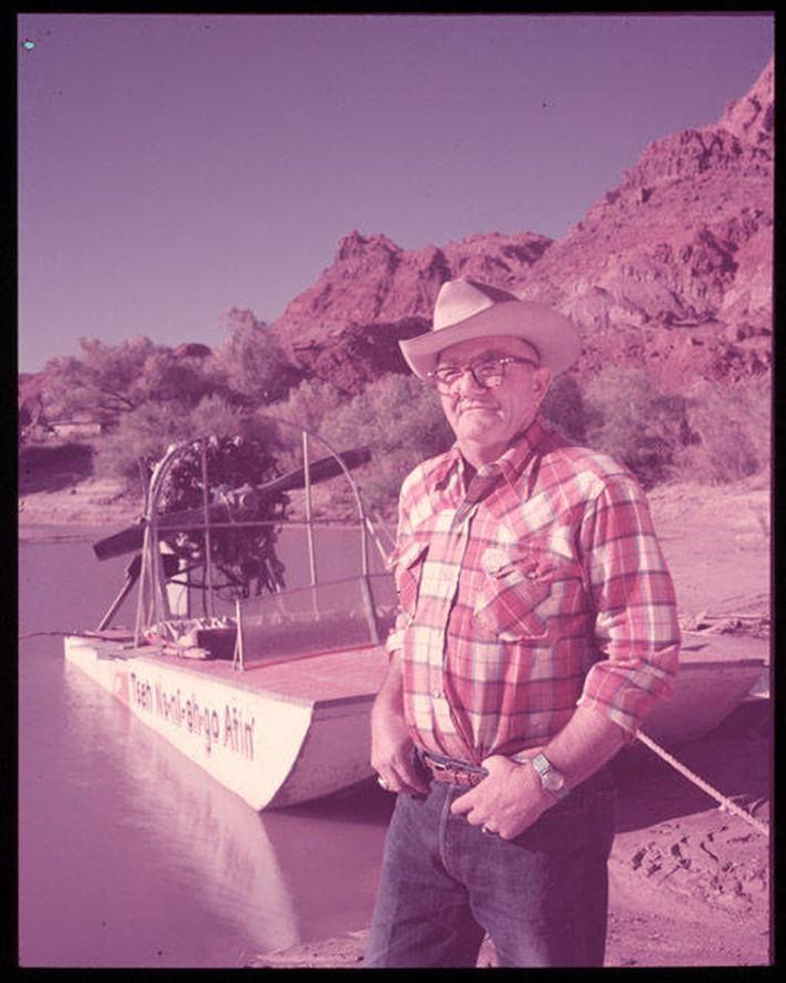
    <summary type="html"><![CDATA[<p><strong><em>Lake Powell is one of the largest reservoirs in the country by both volume and length, with almost a hundred side canyons extending into the surrounding arid, red-hued lands of southern Utah. Its waters quickly became a hub for outdoor recreation, with concessionaires like Art Greene pioneering desert boat-driven tourism.</em></strong></p><img src="https://www.intermountainhistories.org/files/fullsize/b3e159b1b55fa0b91b08098f58109e64.jpg" alt="Art Greene and his commercial river craft, the Tseh Na-ni-ah go Atin (Diné for “trail to the rock that goes over”, in reference to Rainbow Bridge), ca. 1949-1956" /><br/><p>The Glen Canyon Dam, which spans the Colorado River by the Utah-Arizona border, created Lake Powell in 1963. The lake submerged Glen Canyon to hold water and generate energy, and it remains a contested environmental issue. Nonetheless, Lake Powell attracts millions of visitors a year. Congress created the Glen Canyon Recreation Area (GCRA) in 1972 to center the region around leisure just as much as conservation. GRCA also borders Rainbow Bridge National Monument, only accessible by boat or a lengthy hike from the Navajo Nation. Rainbow Bridge, whose establishment predates that of GCRA, holds spiritual significance for nearby Indigenous tribes and attracts visitors looking for a trip “off the beaten path.” As Lake Powell’s waters rose, however, Rainbow Bridge and other surrounding features became more accessible for those traveling by boat.
            Art Greene was an early entrepreneur in the Glen Canyon who provided visitor services before Lake Powell was even created. Previously working as a river guide, cowboy, and oil rigger, to name a few, Greene and his family moved to Arizona from Colorado in 1943. They went on to manage the Marble Canyon Lodge, then bought the Cliff Dweller’s Lodge just down the road in 1949. The lodges, located near the Utah-Arizona border, catered to early river runners and outdoor enthusiasts. Greene launched the first commercial river trips upriver from Lee’s Ferry to Rainbow Bridge (a route that would be interrupted by the dam’s creation). Earl Johnson, his son-in-law, was the main supervisor of the river trips.
As early as 1945, Greene had noticed dam site surveyors in the area, and, after suspecting that the dam would disrupt his business downriver, he jumped at the prospect of lucrative lake tourism. The family acquired a commercial lease on the state grazing land nearby, planning lodging and recreation facilities. The Greenes also built a road, airstrip, and employee infrastructure in the area. The National Park Service (NPS), which had taken over administration duties from the Bureau of Reclamation, granted the Greene family a concession in 1959 to continue construction of the recreation area, now called Wahweap Marina.
By 1966, the family had worked with NPS to develop lodgings and boat ramps, a $3 million project to provide full access to America’s newest “playground”. Earl Johnson ran lake tours aboard boats like the <em>Rainbow</em> <em>Trail</em> for the family’s Canyon Tours, Inc. These tours ranged from daily trips to Rainbow Bridge to five-day overnight excursions. Tour boats brought passengers to features like the Glen Canyon Dam and the various side canyons of Lake Powell. Alongside guided tours, Canyon Tours owned a fleet of rental crafts for private use. As tourist rates increased, the family operation sold its concession to the Del Webb Corporation, a national developer of real estate and recreation properties, in 1976.
Today, Lake Powell’s low water levels not only hinder its water storage and power generating capacity, but also the ability to access features like Rainbow Bridge by boat. Guided tours persist, but are completely dependent on evaporation and drought conditions. Lake Powell still functions as a recreation hub for desert-dwellers in search of rare days on the water, as well as visitors from outside the West looking for deserts, canyon walls, and wide-open spaces.</p><p><em><strong><a href="https://www.intermountainhistories.org/items/show/893">For more (including 6 images) view the original article</a></strong></em></p>]]></summary>
    <published>2025-09-23T15:30:20+00:00</published>
    <updated>2026-04-17T19:32:20+00:00</updated>
    <link rel="alternate" type="text/html" href="https://www.intermountainhistories.org/items/show/893"/>
    <id>https://www.intermountainhistories.org/items/show/893</id>
    <author>
      <name>Anaëlle DePoint, Northern Arizona University</name>
    </author>
  </entry>
  <entry>
    <title type="html"><![CDATA[The Crack at Glen Canyon, 1981 ]]></title>
    <summary type="html"><![CDATA[<p><strong><em><span style="font-weight:400;">In 1981, </span><span style="font-weight:400;">Earth First!</span><span style="font-weight:400;"> staged a demonstration at Glen Canyon Dam, giving the appearance of an attack. The incident placed the group on the national radar, with some calling this the birth of the radical environmental movement.</span></em></strong></p><img src="https://www.intermountainhistories.org/files/fullsize/483deaf10dd730edfd0ff19ddb60c859.jpg" alt="Glen Canyon, circa 1898" /><br/><p><span style="font-weight:400;">Earth First</span><span style="font-weight:400;">! members gathered on March 21, 1981 to protest the Glen Canyon Dam. Completed in 1966, the dam was the subject of much political controversy and protest by environmentalists. The dam flooded Pueblo cliff dwellings containing ancient artifacts; damaged the Colorado River ecosystem and endangered native species; and submerged the Cathedral in the Desert, a beautiful natural monument within the canyon. In the </span><i><span style="font-weight:400;">Earth First! Journal</span></i><span style="font-weight:400;">, the group described the dam as having “drowned the most magical place on the continent.” They claimed the dam as a symbol for humanity’s destruction of the planet, and invited members to join in protest. The demonstration was the focal point of a Spring Solstice and full moon celebration by the group.</span>
<span style="font-weight:400;">Seventy-five members of </span><span style="font-weight:400;">Earth First</span><span style="font-weight:400;">! lined up on the Colorado River bridge at Glen Canyon, carrying protest signs calling for the destruction of the dam and freeing of the river. Several members carried 300-feet of black plastic, then unfurled it over the dam to give the appearance of a large crack. These actions were inspired by </span><i><span style="font-weight:400;">The Monkey Wrench Gang</span></i><span style="font-weight:400;">, in which a group plans to blow up the Glen Canyon Dam. The author of the influential novel, Edward Abbey, attended the 1981 demonstration and gave a speech while standing on the back of a pickup truck. Abbey referred to Glen Canyon as a treasure stolen from the people by greedy developers and politicians, and the dam as an invasion. He urged the protestors to oppose the destruction of the Earth, and resort to sabotage and subversion when political action failed. </span>
<span style="font-weight:400;">As Abbey completed his speech, National Park Service police and Coconino County Sheriff’s deputies arrived. Law enforcement officers questioned protestors and attempted to disperse the crowd. According to </span><span style="font-weight:400;">Earth First</span><span style="font-weight:400;">! founder Dave Foreman, the FBI also investigated the incident and dusted the plastic “crack” for fingerprints. Media attention on the demonstration led to a sudden rise in </span><span style="font-weight:400;">Earth First</span><span style="font-weight:400;">! membership, with new members from across the country expressing interest in the movement. The “cracking” of Glen Canyon Dam is often cited as the first moment of radical direct action within the environmental movement. </span><span style="font-weight:400;">Earth First</span><span style="font-weight:400;">! was suddenly on the national radar as a radical alternative to mainstream environmental groups.</span>
<span style="font-weight:400;">Decades later, Glen Canyon remains a site of controversy. Environmental activists continue to argue for the decommissioning of the dam and restoration of the canyon. Despite growing interest in dam removal, the federal government views Glen Canyon and its reservoir, Lake Powell, as a necessity. Glen Canyon generates electricity for millions of homes, and Lake Powell is used for water storage for the Upper Basin states in the Colorado River Compact.</span></p><p><em><strong><a href="https://www.intermountainhistories.org/items/show/835">For more (including 4 images) view the original article</a></strong></em></p>]]></summary>
    <published>2024-05-27T15:31:48+00:00</published>
    <updated>2026-04-17T19:32:18+00:00</updated>
    <link rel="alternate" type="text/html" href="https://www.intermountainhistories.org/items/show/835"/>
    <id>https://www.intermountainhistories.org/items/show/835</id>
    <author>
      <name>Emily Roth, Northern Arizona University </name>
    </author>
  </entry>
  <entry>
    <title type="html"><![CDATA[A Beach in the Desert: Wahweap Beach]]></title>
    <summary type="html"><![CDATA[<p><strong><em>Originally discovered by the Indigenous tribes in the region and created by the growing reservoir behind Glen Canyon Dam, Wahweap Beach developed into a sought-after vacation spot through the construction of Wahweap Lodge by the Greene Family.</em></strong></p><img src="https://www.intermountainhistories.org/files/fullsize/aeab139905fd748f1dace82ace64c1bb.jpg" alt="Wahweap Beach, ca. 1961-1969" /><br/><p>In the middle of northern Arizona and southern Utah’s high desert sits the Wahweap Beach on the artificial oasis of Lake Powell. Wahweap Beach is the most popular recreational and lodging area on Lake Powell with a little over a million visits and about 425,000 overnight stays in 2021 alone. Along with swimming and sunbathing, beachgoers can kayak, paddleboard, jet ski, and powerboat. Wahweap includes amenities such as an RV-friendly campground, picnic tables, boat rentals, and the Lake Powell Resort, making for many options for how to spend time at the beach.</p><p>However, Wahweap Beach did not always exist. It began due to the rising waters of Lake Powell after the construction of Glen Canyon Dam from 1957 to 1964. Originally, “Wahweap” comes from the Paiute language, meaning “bitter water.” The name warned passing natives about the unsafe drinking water as Wahweap only saw running water during spring run-off and summer monsoons. Toward the end of the thirteenth century, the Ancestral Pueblo people fled the area of modern-day Lake Powell and later, the Navajo (Diné), Ute, and Paiute tribes moved into the area.</p><p>In the early days of Lake Powell, the Bureau of Reclamation owned the land, although it granted leases to Navajo farmers for cattle grazing. Bill Greene and his family purchased the lease that designated Wahweap Beach in 1957 from a Navajo man named Curly Tso. The family decided to invest and worked to acquire land concessions from the Arizona State Land Department. Despite strong competition, the family had the help of Barry Goldwater, Arizona senator, and Stewart Udall, House of Representatives member for Arizona’s 2nd District, and gained a concession to the land in 1959 from the National Park Service (NPS). This allowed the Greene family full control of the recreational use at the southern tip of the lake.</p><p>Construction then began on Wahweap Lodge and Marina, now called Lake Powell Resort, by the Greene’s family business, Canyon Tours, Inc. Bill Greene put in a temporary boat launch facility in 1963, and by 1965, Canyon Tours, Inc. finished building Wahweap Lodge which included forty-four guest rooms. These facilities began attracting tourists to its shores to swim, boat, and fish, thus creating the beach life at Wahweap.</p><p>The expected tourist turn-out was so great that in 1962, the NPS already had plans to develop a visitor center at Wahweap Beach. The Parks’ Services Interpretive Prospectus Glen Canyon National Recreational Draft proposed scientific, historical, and recreational-themed exhibits included at Wahweap. Ultimately, other locations such as the Bull Frog Visitor Center across the lake took on the role of interpretation, and included exhibits on human, geological, and natural history. Today, Wahweap is the most active beach and as of June 2023, its swimming spot, also referred to as “Swim Beach,” has been relocated by Glen Canyon National Recreation Area due to the reservoir’s declining water levels. Wahweap is now further from the boat ramps at the Marina, making for a more secluded beach on which to swim and lounge.</p><p><em><strong><a href="https://www.intermountainhistories.org/items/show/826">For more (including 4 images) view the original article</a></strong></em></p>]]></summary>
    <published>2024-05-22T23:55:14+00:00</published>
    <updated>2026-04-17T19:32:18+00:00</updated>
    <link rel="alternate" type="text/html" href="https://www.intermountainhistories.org/items/show/826"/>
    <id>https://www.intermountainhistories.org/items/show/826</id>
    <author>
      <name>Olivia Hall, Northern Arizona University</name>
    </author>
  </entry>
  <entry>
    <title type="html"><![CDATA[Planet of the Apes and Glen Canyon, Arizona<br />
]]></title>
    <summary type="html"><![CDATA[<p><strong><em>The Glen Canyon National Recreation Area is in the states of Arizona and Utah. Large sections of the region feature in Planet of the Apes, including areas such as Lake Powell. </em></strong></p><img src="https://www.intermountainhistories.org/files/fullsize/5050d00397691fecd242bce17699202d.jpg" alt="Roddy McDowall Planet of the Apes makeup 1974" /><br/><p>Glen Canyon is located in northern Arizona’s Vermilion Cliffs National Park. The Glen Canyon National Recreation Area encompasses 1.25 million acres of land spread across both Arizona and Utah. After the construction of the Glen Canyon Dam in 1966, areas of the Glen Canyon region were flooded, creating the Lake Powell Reservoir. The canyon itself was created by the Colorado River as its flow eroded the land over millions of years.</p><p>Glen Canyon, Lake Powell, and the surrounding desert region were all used by Franklin J. Schaffner in the filming of his 1968 film Planet of the Apes. Starring Charlton Heston as the lead astronaut, Taylor, the film tells the story of a trio of astronauts crash landing on what they believe is an alien world, only to find it inhabited by intelligent apes. The film opens when the three astronauts awake from hibernation on their ship and crash land onto an alien planet. The crew abandons ship and begins rafting down the river. After discovering that the surrounding soil is unable to support life, the astronauts encounter both primitive humans and intelligent ape creatures. A series of interactions with ape creatures, included the antagonist Maurice Evans' Dr Zaius, leads to the death of the crew and Taylor’s temporary loss of his voice. Taylor discovers that the planet is in fact earth after being destroyed by his civilization’s nuclear war.</p><p>The mixture of arid and verdant landscapes present in the Glen Canyon region are used in the film to show how much of the land on the future Earth is uninhabitable. The landscape of the region is used not only to convey the feeling of an alien planet, complete with the Ape City sets and enclaves, but also that of a post-apocalyptic landscape—two of the most popular uses for desert environments in science fiction cinema. The newly flooded Lake Powell and the Colorado river also allowed for the rafting scenes early in the film. Lake Powell was used for the initial crash landing scene, while other regions along the river featured rafting. Recognizable canyon formations feature as backdrops throughout the film. Horseshoe Bend is cast as the entrance to the forbidden zone wherein the ruins of human civilization lie. Filming the scenes within the canyon itself proved difficult due to the terrain, and much of the equipment required for the shoots had to arrive by helicopter.</p><p><em><strong><a href="https://www.intermountainhistories.org/items/show/232">For more (including 3 images) view the original article</a></strong></em></p>]]></summary>
    <published>2018-06-19T18:42:25+00:00</published>
    <updated>2026-04-17T19:32:03+00:00</updated>
    <link rel="alternate" type="text/html" href="https://www.intermountainhistories.org/items/show/232"/>
    <id>https://www.intermountainhistories.org/items/show/232</id>
    <author>
      <name>Isaac F. J. Middleton, Northern Arizona University</name>
    </author>
  </entry>
  <entry>
    <title type="html"><![CDATA[The 1911 Kolb Expedition in Glen Canyon: Part 4 of 5 of the 1911 Kolb Expedition Tour]]></title>
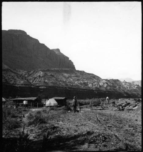
    <summary type="html"><![CDATA[<p><strong><em>A detailed account of two photographers’ river trip through Glen Canyon, a land of amphitheaters, arches, and ruins.</em></strong></p><img src="https://www.intermountainhistories.org/files/fullsize/746512ee18801850746c8da7638e720b.jpg" alt="Hite Ranch in Utah, 1911" /><br/><p>Emery and Ellsworth Kolb’s experience in Glen Canyon began at the remote settlement of Hite, Utah. There, the two brothers recovered from the previous trials of Cataract Canyon and wrote home to their families. Staying only a night, the duo waved goodbye to local legend Cass Hite and began the next leg of their trip to Bright Angel, a four- day journey to Lee’s Ferry. From November 3rd  to November 6th, 1911, the brothers became some of the only people to photograph the original landscapes in Glen Canyon, which is noted for ancestral native ruins, arches, amphitheaters, domes, and hieroglyphics. This area is now inundated by Lake Powell, and modern boat access is much easier and more comfortable than negotiating the river in an early 20th century Racine Co. wooden craft used by the brothers. Emery’s and Ellsworth’s primary motive for the expedition was to capture material for their photography business, and they took full advantage of Glen Canyon’s steady waters and picturesque views to obtain film that would captivate the public for decades to come. </p><p>The brothers enjoyed exploring the region’s cliff dwellings and natural stone bridges. Ellsworth described in his book a fascination with those near the confluence of the Escalante River, remarking, “What a story these cliffs could tell!” He then likened the tribes of the Southwest to European factions, making their last stand on the cliffs, and comparing the Colorado to the other great desert river - the Nile. At Deep Canyon, the brothers refocused on the river as it meandered through a sheer, narrow gorge. They had trouble finding a suitable campsite above the confluence with the San Juan; the few banks consisted of quicksand and mud. Under a full moon they drifted past the San Juan and into a black gorge where no moonlight entered. When they heard roaring water, the brothers scrambled out of their boats onto the bank for the night. The next morning they discovered the rapid they had heard was nothing more than swift water, and were astounded by the ominous Navajo Mountain towering above. This sighting marked a sort of premature homecoming, as they had often seen the rounded peak from their home at the Grand Canyon. After spending a day searching unsuccessfully for Rainbow Bridge, the brothers set their final camp in Glen Canyon at Ute Ford, otherwise known as the Crossing of the Fathers. Using a swift current and some hard paddling, Emery and Ellsworth floated into Lee’s Ferry the evening of November 6th. They got a hot meal and made boat repairs before taking on the last leg of their journey - into the Grand Canyon. </p><p>Without the constant demands of whitewater, Glen Canyon gave the two photographers much-welcomed free time to explore the river and its tributaries. The brothers had no way of knowing it at the time, but their careful descriptions and photography still provide a rare look into a lost canyon.</p><p><em><strong><a href="https://www.intermountainhistories.org/items/show/57">For more (including 4 images) view the original article</a></strong></em></p>]]></summary>
    <published>2017-06-05T17:07:20+00:00</published>
    <updated>2026-04-17T19:31:58+00:00</updated>
    <link rel="alternate" type="text/html" href="https://www.intermountainhistories.org/items/show/57"/>
    <id>https://www.intermountainhistories.org/items/show/57</id>
    <author>
      <name>Jonas Dunlap, Northern Arizona University</name>
    </author>
  </entry>
</feed>