<?xml version="1.0" encoding="UTF-8"?>
<feed xmlns="http://www.w3.org/2005/Atom">
  <title type="text">Intermountain Histories</title>
  <updated>2026-04-17T19:32:16+00:00</updated>
  <generator uri="http://framework.zend.com" version="1.12.20">Zend_Feed_Writer</generator>
  <link rel="alternate" type="text/html" href="https://www.intermountainhistories.org/"/>
  <link rel="self" type="application/atom+xml" href="https://www.intermountainhistories.org/items/browse?output=rss2"/>
  <id>https://www.intermountainhistories.org/</id>
  <author>
    <name>Intermountain Histories</name>
    <uri>https://www.intermountainhistories.org</uri>
  </author>
  <link rel="hub" href="https://pubsubhubbub.appspot.com/"/>
  <entry>
    <title type="html"><![CDATA[James P. Beckwourth: Enslaved African to Crow Chief]]></title>
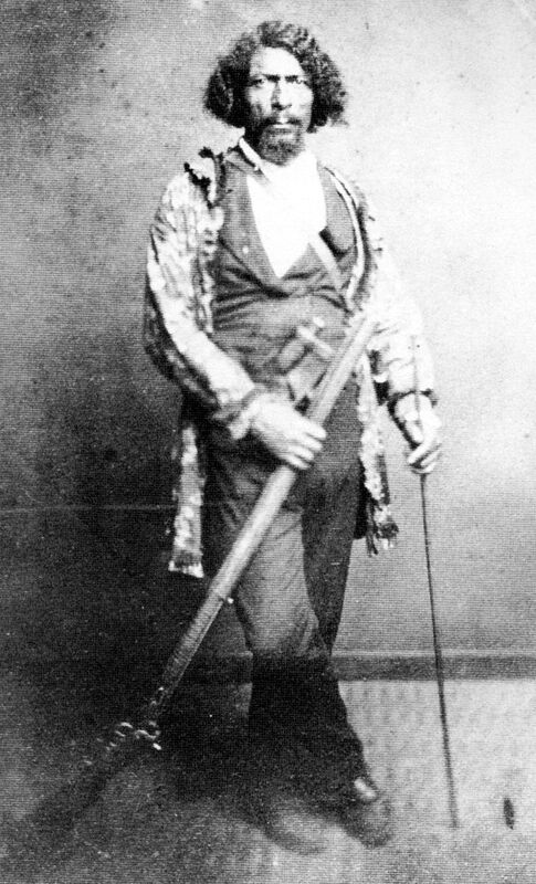
    <summary type="html"><![CDATA[<p><strong><em>James P. Beckwourth, born to a mixed-race couple in 1798, ended up becoming the Chief of the Crows. </em></strong></p><img src="https://www.intermountainhistories.org/files/fullsize/b9b6bc63d500243cc53b88766daaadf2.jpg" alt="Beckwourth in His Regalia." /><br/><p><span style="font-weight:400;">About a decade before his death, James Pierson Beckwourth recounted the events of his life to Thomas Bonner, which was published in 1856 as </span><i><span style="font-weight:400;">The Life and Adventures of James P. Beckwourth: Mountaineer, Scout, Pioneer and Chief of the Crow Nation</span></i><span style="font-weight:400;">. Although historians have criticized the account for Beckwourth’s embellishments—especially his role in certain events—the account reveals incredible details of the African American Chief. </span>
<span style="font-weight:400;">James P. Beckwourth had one of the most exciting lives among mountain men. Born on April 26, 1798, near Fredericksburg, Virginia, the son of Irish aristocrat Sir Jennings Beckwith and his mulatto servant, Miss Kill. In total, Miss Kill bore a dozen more children by Beckwith. Beckwith moved his family to St. Louis in 1809, where he could raise his mixed-race progeny as family.  </span>
<span style="font-weight:400;">When the family moved to St. Louis in 1809, Beckwith apprenticed James as a blacksmith with George Casner and John Sutton. Beckwith manumitted his son when Beckwourth turned 18. After a few years mining lead on the Galena River, James returned to St. Louis and joined the Ashley-Smith fur trapping enterprise in 1824. He attended the first Rocky Mountain Rendezvous on Henry’s Fork of the Green River on July 1, 1825. He was one of the first black men to enter and trap in the soon-to-be Utah Territory.</span>
<span style="font-weight:400;">Perhaps his most intriguing adventure was his journey to become a chief of the Crow Nation. On their way from the Rocky Mountains to the Yellowstone River, Beckwourth and his fur-trapping companion, Jim Bridger, left their trapping group to set out on their own for a few days. Beckwourth and Bridger split up at a river’s fork, planning to meet up after a few hours. Beckwourth followed the stream when suddenly he found himself surrounded by Crows. He had a long history of escaping from Indians intent to do him harm, but this time he knew he could not escape and pleaded for mercy. The Crows took Beckwourth to their chief Big Bowl, who mistook Beckwourth for his long-lost son, calling him a “great warrior.” This may have been a ritualistic adoption commonplace to replace loved ones lost in warfare. Beckwourth had taken part in many altercations with other tribes such as the Blackfeet and Cheyenne, enemies of the Crows. When Big Bowl heard about a warrior who had slain so many of his enemies, he adopted him. The people of the village celebrated and gave abundant gifts to Beckwourth, including a wife. </span>
<span style="font-weight:400;">While his mountaineer friends believed him dead, Beckwourth started a new life as a member of the Crows. He participated in many battles against enemy tribes, mostly with Blackfeet and Cheyenne warriors. Beckwourth’s strength and courage in battle continued to impress the Crows and he lived up to his reputation as a great warrior. In one battle, the Chief Arapooash died, and the tribe unanimously elected Beckwourth as one of their leaders.</span>
<span style="font-weight:400;">Beckwourth helped found a trading post in Pueblo, Colorado, supplied miners in the California gold rush, and piloted a wagon road through the Sierra-Nevadas in 1850. He supplied miners in the Colorado gold rush of 1859. He was present at the tragic massacre of Black Kettle’s peaceful Cheyenne village at Sand Creek on November 29, 1864. He worked as an army scout. Some accounts report he died on October 29, 1866, but the details are unverifiable. </span></p><p><em><strong><a href="https://www.intermountainhistories.org/items/show/748">For more (including 4 images) view the original article</a></strong></em></p>]]></summary>
    <published>2023-04-11T18:58:24+00:00</published>
    <updated>2026-04-17T19:32:16+00:00</updated>
    <link rel="alternate" type="text/html" href="https://www.intermountainhistories.org/items/show/748"/>
    <id>https://www.intermountainhistories.org/items/show/748</id>
    <author>
      <name>Marcus Anderson, Brigham Young University</name>
    </author>
  </entry>
  <entry>
    <title type="html"><![CDATA[Daniel, Wyoming Rendezvous of 1837]]></title>
    <summary type="html"><![CDATA[<p><strong><em>Alfred Jacob Miller attended the enormous 1837 rendezvous with Scottish adventurer Sir William Drummond Stewart. His paintings of the gathering have helped in creating a romantic image of the West that persists today.</em></strong></p><img src="https://www.intermountainhistories.org/files/fullsize/fa78dd356f020a8a54f55205fb588986.jpg" alt="Rendezvous in 1837" /><br/><p>Near what is today the small western Wyoming town of Daniel, fur traders held the rendezvous of 1837 along the Green River, in the shadow of the Wind River Range of mountains. Over the years, trappers and traders held eight rendezvous in Green River Valley, out of a total fifteen held between 1825 and 1840.
The 1837 rendezvous was one of the largest ever held. Alfred Jacob Miller, an artist known for his paintings of the American West, attended the rendezvous with Sir William Drummond Stewart, a British military officer and adventurer who was touring the American West. Stewart hired Miller to sketch their trip through the West. When Miller arrived at Green River, he was struck by the sight of hundreds of white lodges stretched out into the distance. He camped out under the Wind Mountains among over 3,000 Native Americans, many of whom were from the Snake tribe. Osborne Russell, a fur trapper, also recorded detailed descriptions of the events.
Fur trappers dedicated the first day to festivities and celebration; men gambled, raced horses, and gathered in small groups to tell their stories. The mountain men used animal skin for clothes and bedding, and their diets consisted mainly of meat from any animals they could catch. The American Fur Company arrived the second day to raise their tents and begin trading, and Thomas Fitzpatrick arrived on July 5 with the supply train: twenty mule-drawn carts. Trappers again complained about the highly inflated costs of goods in the mountains. There was a high demand for alcohol, and a one gallon sold for $64. The St. Louis traders brought newspapers as well as letters from friends and family members for the mountain men.
In addition to the relationships white men made with each other, Miller also observed white–Native American relations at the rendezvous, including gift exchanges and the smoking of a ceremonial pipe. He even observed the marriage between native woman and a half-Native American trapper named Francois. Francois paid the bride’s family in currency and material goods, giving the marriage an economic context. Miller also took frequent trips to a chain of lakes to take sketches of the scenery. Trading lasted a few days, after which traders packed up the furs and shipped them to St. Louis, or “the States” as Russell called them.
Daniel, Wyoming is now a very small town with a population of 150 in Sublette County, which is named after fur trader William Sublette. The Upper Green River Rendezvous Site became a National Historic Landmark in 1963 and was added to the National Register of Historic Places in 1966. Annual rendezvous reenactments are held in the nearby town of Pinedale, seat of Sublette County.</p><p><em><strong><a href="https://www.intermountainhistories.org/items/show/613">For more (including 5 images) view the original article</a></strong></em></p>]]></summary>
    <published>2022-06-11T01:34:37+00:00</published>
    <updated>2026-04-17T19:32:13+00:00</updated>
    <link rel="alternate" type="text/html" href="https://www.intermountainhistories.org/items/show/613"/>
    <id>https://www.intermountainhistories.org/items/show/613</id>
    <author>
      <name>Emily Roth, Northern Arizona University</name>
    </author>
  </entry>
  <entry>
    <title type="html"><![CDATA[Pierre’s Hole Rendezvous of 1832]]></title>
    <summary type="html"><![CDATA[<p><strong><em>The 1832 rendezvous was one of the largest in the span of the fur trade. It made its place in history for the famous Battle of Pierre’s Hole.</em></strong></p><img src="https://www.intermountainhistories.org/files/fullsize/585628b2f434f3a47ea18780b5a0af33.jpg" alt="History of Pierre’s Hole" /><br/><p>Pierre’s Hole is a valley in Eastern Idaho, located on the west slope of the Teton Mountain Range at an elevation of 6,109 feet. Today, the valley is officially known as Teton Valley, and the Teton River flows through it. The Rocky Mountain Fur Company selected Pierre’s Hole in 1832 as a “pleasant place” for a rendezvous, with streams ideal for trapping beaver.
The Rocky Mountain Fur Company contracted William Sublette to supply the rendezvous and remove beaver pelts, and Sublette arrived on July 8, 1832, with 100 merchandise-carrying mules. Pierre’s Hole was one of the largest rendezvous yet: over 1,000 white and Native American trappers attended, and horses and mules numbered between 2,000 and 3,000.
Signs that the rendezvous could go wrong started when Thomas Fitzpatrick, an Irish American mountain man and trapper, reached the rendezvous late after a party of Gros Ventre Native Americans attacked him, prompting him to hide in the mountains for five days. Despite Fitzpatrick’s uneasy encounter, the rendezvous carried on and concluded trading on July 17. The fur company collected 168 packs of furs that contained around 60 pelts per pack, worth a total of $58,305.
Milton Sublette, a new owner in the company, led out a party of men out of the rendezvous. They travelled six to eight miles before camping for the night. The following day, a party of Gros Ventre and Blackfeet approached the encampment. However, indigenous party soon realized they were outnumbered by the trappers, and they waved a white flag of peace. Antoine Godin and a Flathead chief were sent to meet the Blackfoot chief for peace talks, but both men already hated the Blackfeet. Godin’s father had been killed by members of the Blackfeet, and the Flathead Nation also had disputes with the Blackfeet. Acting on a previously coordinated plan, when Godin grasped the Blackfeet chief’s hand to shake, the Flathead chief shot him.
Upon seeing their chief attacked, the Blackfeet retreated into the nearby timber and immediately began building a makeshift fort. William Sublette soon received news of the outbreak of violence, and he arrived with a large group of reinforcements. Seeing they were greatly outnumbered, the Blackfeet further retreated while the traders pressed on and fired into the woods. The traders made little progress against the fort as the day progressed, but the battle eventually ended due to a miscommunication between a trapper and a member of the opposing Blackfoot party. The trapper mistakenly believed that 600–800 Blackfeet were headed for the unprotected rendezvous site, so the fur trapping party hurried back to Pierre’s Hole to protect it. The traders soon realized the error, but by then the Blackfeet party had already abandoned their makeshift fort. On the fur trappers’ side, five whites and seven Native Americans had died; the trappers and traders killed an estimated twenty-six Blackfoot.
Historians added the Pierre’s Hole battle site to the National Register of Historic Places in 1984. A historic marker in Driggs, Idaho, located along Highway 33, describes the significance of Pierre’s Hole as a center for the fur trade. It is now a small town with a primarily agricultural focus, appreciated for its beautiful natural scenery.</p><p><em><strong><a href="https://www.intermountainhistories.org/items/show/612">For more (including 4 images) view the original article</a></strong></em></p>]]></summary>
    <published>2022-06-11T01:11:42+00:00</published>
    <updated>2026-04-17T19:32:13+00:00</updated>
    <link rel="alternate" type="text/html" href="https://www.intermountainhistories.org/items/show/612"/>
    <id>https://www.intermountainhistories.org/items/show/612</id>
    <author>
      <name>Emily Roth, Northern Arizona University</name>
    </author>
  </entry>
  <entry>
    <title type="html"><![CDATA[Bear Lake Rendezvous of 1827]]></title>
    <summary type="html"><![CDATA[<p><strong><em>The Bear Lake rendezvous in 1827 marked the first year under a new company. Inflated supply prices and conflicts with the local Blackfoot tribe stunted the success of this meeting.</em></strong></p><img src="https://www.intermountainhistories.org/files/fullsize/ff202bfc65cacc11854cdf61e40ccfb4.jpg" alt="Bear Lake today" /><br/><p>Bear Lake is a freshwater body on the Utah–Idaho border that is situated within a small valley, at an elevation of 5,923 feet. Eight miles long and twenty miles wide, calcium carbonates suspended in the lake water give it a unique green-blue hue, earning Bear Lake the nickname “Caribbean of the Rockies.” Fur trappers and traders from the 1827 rendezvous also referred to the area as “Sweet Lake.” The newly formed Smith, Jackson, and Sublette firm chose Bear Lake’s south shore for both the 1827 and 1828 Rocky Mountain rendezvous, making the site the new trade system’s first lakeside location. The site would have been a part of Mexico’s territory during that time. Today, the site is located near the city of Laketown, Utah.
William Henry Ashley was not in attendance at the 1827 rendezvous, as he had sold his share in the fur company to Smith, Jackson, and Sublette the previous year. However, he was still contracted to supply merchandise for the rendezvous. Fur trappers in attendance that year complained about “exorbitant” prices of supplies that year, as described by explorer Daniel Trotter Potts in a letter to a friend. He explained the difficulty of making profits in the fur trade due to these high prices, which were inflated and known as “mountain prices.” For trappers, this was one downside of the centralized rendezvous system.
In a lighter moment, when Jedediah Smith arrived at the rendezvous late, traders already present celebrated his arrival by firing a cannon. Some worried he had become lost while making the trip from California. Before he could miss the rendezvous, though, Smith met a Snake Tribe encampment north of the Salt Lake who informed him of the Bear Lake rendezvous twenty-five miles away, and he made it in time for the traders to welcome him.
The Bear Lake rendezvous of 1827 was significant due to a violent skirmish with members of the Blackfeet Nation. Allegedly, the conflict began when Blackeet individuals entered camp to murder a man and woman from the Snake tribe. The white traders already had ongoing conflicts with the Blackfeet, so they allied with Snake tribe trappers in what became a violent battle. A small number of whites were injured in the skirmish, though none died, but multiple Native Americans died. The exact number of fatalities remains unknown, however.
Bear Lake was opened as a Utah State Park in 1862. Rendezvous Beach on the south shore is named in honor of the 1827 and 1828 rendezvous held there. The lake has since become a popular attraction for tourists and sports enthusiasts with many recreational activities available such as fishing, hiking, waterskiing, and swimming. The area is also notable for its raspberries, which thrive in the Bear Lake valley’s climate. During the summer Raspberry Days festival, there are sometimes rendezvous events included where attendees can learn about frontier history and recreate the mountain man lifestyle.</p><p><em><strong><a href="https://www.intermountainhistories.org/items/show/611">For more (including 5 images) view the original article</a></strong></em></p>]]></summary>
    <published>2022-06-11T00:14:11+00:00</published>
    <updated>2026-04-17T19:32:13+00:00</updated>
    <link rel="alternate" type="text/html" href="https://www.intermountainhistories.org/items/show/611"/>
    <id>https://www.intermountainhistories.org/items/show/611</id>
    <author>
      <name>Emily Roth, Northern Arizona University</name>
    </author>
  </entry>
  <entry>
    <title type="html"><![CDATA[Cache Valley Rendezvous of 1826]]></title>
    <summary type="html"><![CDATA[<p><strong><em>Cache Valley was the site of the second rendezvous organized in the Rocky Mountains by white fur traders. This year marked a shift in ownership of fur industry interests, as well as a shift in the atmosphere of the event.</em></strong></p><img src="https://www.intermountainhistories.org/files/fullsize/cba1adc9c85fc22f600d3fcd3d99d81f.jpg" alt="Cache Valley Mountains" /><br/><p>Cache Valley is a high mountain valley in northern Utah, near the border with Idaho. Although there has been historical debate as to whether the 1826 rendezvous was held specifically in Cove or Hyrum, the contemporary consensus is that Hyrum is the accurate location. Cache Valley is named after the caches fur trappers used to store their pelts and supplies. Fur trappers referred to the valley as Willow, for the many willows which grew in the area. William Henry Ashley, founder of the Rocky Mountain Rendezvous, chose the location in part for the abundance of beavers around the banks of the Bear River. The Rocky Mountain Fur company had also held the spring hunt of 1826 in northern Utah, making Cache Valley a convenient place for the summer rendezvous.
Ashley arrived with the supply train at Cache Valley on July 25 along with Jedediah Smith. In contrast to the business-focused atmosphere of the first rendezvous, the 1826 meeting was more a social gathering and celebration. It lasted for at least a month, possibly up to eight weeks. This was the first year that alcohol was present, and later rendezvous also featured spirits. In keeping with the Trade and Intercourse Act of 1790—which required a trading post for legal fur trading—fur traders built Fort Defiance, a settlement of log cabins and brush shelters to use in winter months.
Traders packed the furs and shipped them to St. Louis once trading at the rendezvous concluded. Ashley had decided to leave the fur industry after a profitable winter season, and he sold his interests to Jedediah Smith, David E. Jackson, and William Sublette as they headed to St. Louis along the Bear River. The men purchased surplus supplies at 150%, to be paid over the next five years in either currency or beaver. The new firm also contracted Ashley to purchase and transport supplies for new rendezvous locations in the future. He had managed to make over $80,000 from the last two meetings, clearing his debts and giving him a small fortune. In a speech, he declared “I now wash my hands of the toils of the Rocky Mountains.” At the 1826 rendezvous, the pelts amounted to a worth of $60,000. Jackson and Sublette then took groups of trappers north to Idaho and Wyoming to begin the fall hunt.</p><p><em><strong><a href="https://www.intermountainhistories.org/items/show/610">For more (including 4 images) view the original article</a></strong></em></p>]]></summary>
    <published>2022-06-10T23:25:23+00:00</published>
    <updated>2026-04-17T19:32:13+00:00</updated>
    <link rel="alternate" type="text/html" href="https://www.intermountainhistories.org/items/show/610"/>
    <id>https://www.intermountainhistories.org/items/show/610</id>
    <author>
      <name>Emily Roth, Northern Arizona University</name>
    </author>
  </entry>
  <entry>
    <title type="html"><![CDATA[McKinnon, Wyoming: First Rocky Mountain Fur Trade Rendezvous]]></title>
    <summary type="html"><![CDATA[<p><strong><em>The first annual rendezvous in Wyoming brought traders and trappers together, allowing for an exchange of furs and supplies in a centralized location. </em></strong></p><img src="https://www.intermountainhistories.org/files/fullsize/f8e18f3075d7b772ef7540c3ae6b56d5.jpg" alt="Rendezvous road marker" /><br/><p><p style="line-height:150%;margin:0in 0in 6pt 0in;"><span style="color:#000000;">McKinnon is a small town in southwest Wyoming, near the Utah border. Fur traders held the first Rocky Mountain Rendezvous north of present-day McKinnon, along the Henry’s Fork River. Founder William Ashley chose the site in 1825 for its proximity to a major river and abundance of open space, necessary to host such a large event with thousands of people and their horses. For this first rendezvous, Ashley wrote in his diary that he planned to leave directions for trappers buried underneath a mound of vermillion-painted rocks near the junction of two rivers.</span>

<p style="line-height:150%;margin:0in 0in 6pt 0in;"><span style="color:#000000;">Three years earlier, in 1822, William Henry Ashley and Andrew Henry had partnered to form the Rocky Mountain Fur Company, and they advertised that they sought to hire one hundred “enterprising young men.” This call to adventure drew individuals to the mountains, some of whom later became the stuff of legends. Ashley decided that a movable meeting would be a more efficient way of trading, rather than an established trading post to which trappers would have to travel and return. </span>Merchants journeyed from St. Louis to meet with Euro-American and indigenous trappers in their own environment, exchanging pelts for guns, knives, beads, traps, and other necessary supplies. The rendezvous were to be held annually at locations throughout the interior West in the summer, when beaver pelts were of lower quality. <span style="color:#000000;">The location for the next rendezvous would then be shared before the current meeting adjourned.</span>

<p style="line-height:150%;margin:0in 0in 6pt 0in;"><span style="color:#000000;">Ashley’s first fur trade rendezvous proved a financial success: in all, there were around 120 men in attendance at the first rendezvous, including both white and Native American trappers. Jedediah Smith—a famed mountain man and explorer credited with rediscovering the South Pass—accompanied Ashley on this trip. Other famous mountain men were said to have also attended, including Etienne Provost and a young Jim Bridger. Although the rendezvous system was originally planned as a solely economic exchange, it also became a time of festivities for the mountain men. They gambled, told stories, drank alcohol, and played games. After the 1825 rendezvous ended, William Ashley packed his pelts onto horses, brought them to the Bighorn River, and shipped them off to St. Louis. That year, their load of pelts valued $50,000.</span>

<p style="line-height:150%;margin:0in 0in 6pt 0in;"><span style="color:#000000;">Today, McKinnon is a census-designated place with a population of less than sixty people. Near where the 1825 rendezvous was held, there is a roadside marker commemorating the significance of the event and the rendezvous system as a whole. It describes the rendezvous as a “raucous social event” where “mountain men swapped stories, tested their skills, and shared news of friends.” This event remains an important part of the area’s history, and it marked a significant moment in the history of the American West.</span>
</p><p><em><strong><a href="https://www.intermountainhistories.org/items/show/609">For more (including 5 images) view the original article</a></strong></em></p>]]></summary>
    <published>2022-06-10T22:21:52+00:00</published>
    <updated>2026-04-17T19:32:13+00:00</updated>
    <link rel="alternate" type="text/html" href="https://www.intermountainhistories.org/items/show/609"/>
    <id>https://www.intermountainhistories.org/items/show/609</id>
    <author>
      <name>Emily Roth, Northern Arizona University</name>
    </author>
  </entry>
  <entry>
    <title type="html"><![CDATA[Jean-Baptiste Charbonneau’s Grave]]></title>
    <summary type="html"><![CDATA[<p><strong><em>Born in February 1805, Jean-Baptiste Charbonneau accompanied the Lewis and Clark Expedition as an infant before becoming a fur trader, guide, alcalde, and then a hotel manager in California.</em></strong></p><img src="https://www.intermountainhistories.org/files/fullsize/01db17a0c012fd0f8a8d4751a3066439.jpg" alt="Charbonneau gravesite" /><br/><p>Jean-Baptiste Charbonneau, son of Sacagawea and Toussaint Charbonneau, accompanied his parents on Meriwether Lewis and William Clark’s expedition for the Corps of Discovery. Although a small infant, he made the entire trek from North Dakota to the Pacific Coast and back to the Mandan Villages on the Knife River. After Sacagawea’s death in December 1812, William Clark legally adopted Jean-Baptiste and his little sister Lisette. Clark provided an education for the two children at a Catholic boarding school in St. Louis. This education opened up numerous opportunities for Jean-Baptiste throughout his life.
As an adult, Jean-Baptiste spent a substantial amount of time in Europe where he learned additional languages and skills. Returning to America, he joined the fur trade, working as a trapper with the Rocky Mountain Fur Company. His extensive knowledge of the terrain enabled him to serve as a guide for explorers, as well as for the Mormon Battalion on their route from Leavenworth to San Diego in 1846 during the Mexican–American War.
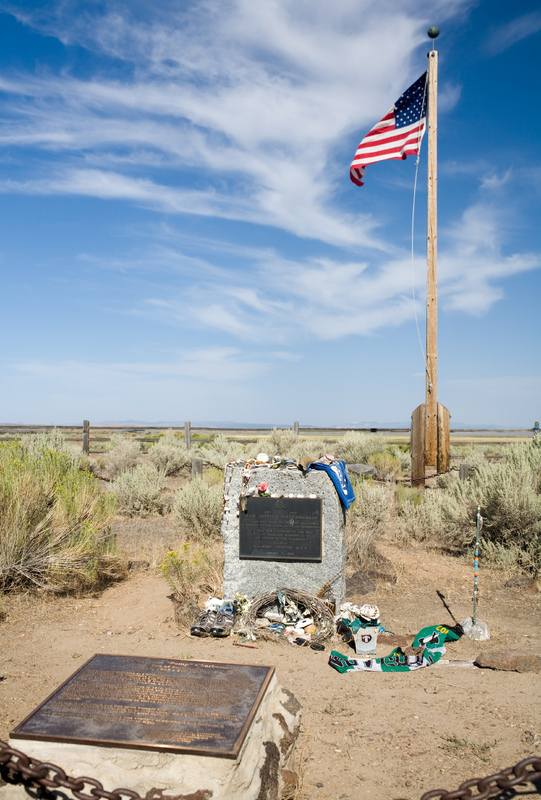
While in California, Charbonneau worked as an alcalde (mayor), panned for gold, provided interpretation services, and operated a hotel in Auburn, California. After the American Civil War and toward the end of his life, Charbonneau worked odd jobs until he learned about gold and silver strikes in Idaho and Montana. On his way to the mining rushes he traveled through Danner, Oregon, but shortly after crossing the Jordan Creek and the Owyhee River, he fell ill (likely of pneumonia) and died at sixty-one years old. Oregonians memorialized Charbonneau by erecting and dedicating a plaque to him in Danner. His place of death is located just over the border of Oregon and is close to the Lemhi Shoshone Nation of Idaho, the likely birthplace of his mother, Sacagawea.</p><p><em><strong><a href="https://www.intermountainhistories.org/items/show/585">For more (including 3 images) view the original article</a></strong></em></p>]]></summary>
    <published>2022-04-09T07:02:41+00:00</published>
    <updated>2026-04-17T19:32:12+00:00</updated>
    <link rel="alternate" type="text/html" href="https://www.intermountainhistories.org/items/show/585"/>
    <id>https://www.intermountainhistories.org/items/show/585</id>
    <author>
      <name>Taylor Mansfield, Brigham Young University</name>
    </author>
  </entry>
  <entry>
    <title type="html"><![CDATA[Fort Hall: Nathaniel J. Wyeth’s Snake River Outpost]]></title>
    <summary type="html"><![CDATA[<p><strong><em>Nathaniel J. Wyeth established a fort along the Snake River that acted as a significant military and economic waypoint to the American West. Even after passing from his hands, the fort maintained its strategic and even religious significance.</em></strong></p><img src="https://www.intermountainhistories.org/files/fullsize/2b5558685da96adff0223558e857869c.jpg" alt="Fort Hall replica" /><br/><p>Boston inventor and businessman Nathaniel J. Wyeth conducted two separate expeditions to the Pacific Northwest in 1832 and 1834 with his Columbia River Fishing and Trading Company. On his latter expedition, Wyeth established a fort in what is now Idaho and named it after his traveling partner, Hall J. Kelly. While the longevity of Wyeth’s company was limited, Fort Hall stood as an essential location for the military, Oregon Trail, and California Tsrail for decades. Its replica now stands as a long-lasting monument to the Rocky Mountain fur trade and mountain man era of the 1830s.
Located at the future junction of the California and Oregon overland trails, Fort Hall transitioned from a fur trade post to a vital resupply destination for American overlanders, Indigenous peoples, and fur traders alike. In a letter to his uncle Jarvis on October 6, 1834, Wyeth described the fort: “Its Bastions stand a terror to the sculking Indian and a beacon of saf[e]ty to the fugitive hunter.”
Even after the fort was sold to the Hudson Bay Company in 1836, and later purchased by the U.S. military, it remained an important landmark for the next 80 years. Its significance came as no surprise to Wyeth. Its strategic location on the Snake River made it an ideal spot for transferring supplies and for troop garrisons on the frontier. In his statement of facts concerning the sale of the fort he wrote: “disposing of the property to the best advantage. All the property in the interior including Fort Hall was sold, it being necessary to retain that post, to keep up a garrison for its defense against the Indians, and to forward annual supplies to it, an operation at that time beyond our means.”
What made Fort Hall especially unique to the history of American expansionism was the presence of Protestant American missionaries. While many European powers had colonized through religion, this was one of the first official ecumenical efforts to spread religious beliefs in this American region. This exemplified how Manifest Destiny envisioned expansion not only economically, but also religiously, as America established its presence as a power on the frontier.
There are only seven American-built forts along the Oregon Trail. Each stand as a legacy to American expansion. While Nathaniel Wyeth only maintained the fort for two years, the fort was built on principles which came to define America as a nation.</p><p><em><strong><a href="https://www.intermountainhistories.org/items/show/580">For more (including 3 images) view the original article</a></strong></em></p>]]></summary>
    <published>2022-03-12T10:30:23+00:00</published>
    <updated>2026-04-17T19:32:12+00:00</updated>
    <link rel="alternate" type="text/html" href="https://www.intermountainhistories.org/items/show/580"/>
    <id>https://www.intermountainhistories.org/items/show/580</id>
    <author>
      <name>Ruth Hardy, Brigham Young University</name>
    </author>
  </entry>
  <entry>
    <title type="html"><![CDATA[American Settlement of Jackson Hole, Wyoming<br />
]]></title>
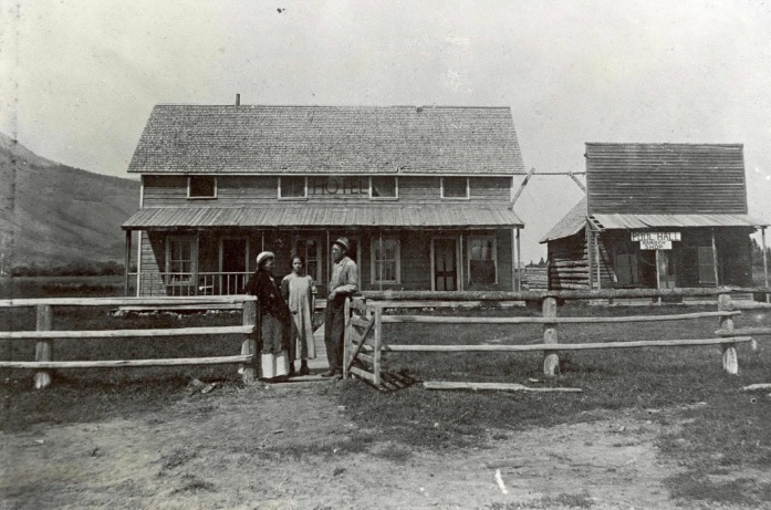
    <summary type="html"><![CDATA[<p><strong><em>In the late 19th century, Jackson Hole, Wyoming was home to seasonal hunters and fur trappers. When the Wilson-Cheney settling company crossed Teton Pass in 1889, they brought with them women, children, and the trappings of civilization to the valley.</p></strong></p><img src="https://www.intermountainhistories.org/files/fullsize/04ae0cedc5be58f1bf0b9a20cf1389af.jpg" alt="First Post Office" /><br/><p>In 1878, Sylvester Wilson and his family, members of The Church of Jesus Christ of Latter-day Saints (LDS), settled what became Wilsonville, UT. A decade later, in the face of a prolonged drought, Sylvester and his son-in-law, Selar Cheney, moved their families north seeking better conditions. Initially intending on settling in St. Anthony, ID, the group chanced upon Sylvester’s brother, Nick Wilson, who convinced them to settle instead in Jackson Hole, a fertile and relatively untouched valley in Wyoming.</p><p>Leaving most of their possessions in Idaho, the company crossed Teton Pass in 1889. As the first company to bring women, children, and wagons into the valley, the group enlarged an indigenous trail through the pass, cutting aside trees and other growth. After two weeks and 88 miles of rough terrain, the company reached Jackson Hole on November 11, 1889.</p><p>When the Wilson-Cheney company arrived, the valley was home to only 28 individuals. The large company more than doubled the valley’s population, and quickly began constructing various elements of American civilization. In 1891, following the deaths of Sarah and Joseph Wilson, they established the valley’s first cemetery. In 1892, they opened the first school in Sylvester Wilson’s home. In 1893, Nick Wilson opened a hotel and post office at the base of Teton Pass.</p><p>The company’s greatest impact on the valley, however, was the clearing of Teton Pass for wagon travel. The trail the Wilson-Cheney company expanded allowed more homesteaders and merchants to access the valley. From its initial population of roughly 28 in 1889, the valley grew to 638 men, women, and children by 1900. The short-lived town of Cheney, one of the company’s settlements, consisted itself of almost 150 people by 1910, and included a blacksmith, carpenter, postmaster, doctor, and taxidermist. Although the LDS settlers mostly left the valley during economic struggles in the 1920s and 1930s, their initial settlements in Jackson Hole brought civilization to the otherwise rugged, mountainous backcountry, and opened the door for countless more settlers.</p><p><em><strong><a href="https://www.intermountainhistories.org/items/show/283">For more (including 3 images) view the original article</a></strong></em></p>]]></summary>
    <published>2019-02-09T07:15:45+00:00</published>
    <updated>2026-04-17T19:32:04+00:00</updated>
    <link rel="alternate" type="text/html" href="https://www.intermountainhistories.org/items/show/283"/>
    <id>https://www.intermountainhistories.org/items/show/283</id>
    <author>
      <name>Matthew Cheney, Brigham Young University</name>
    </author>
  </entry>
  <entry>
    <title type="html"><![CDATA[Davey Jackson of the Rockies]]></title>
    <summary type="html"><![CDATA[<p><strong><em>The Rocky Mountain Fur Trade created huge economical gain for those at the top. David Jackson played a key role, although very little is known about his role within the fur trade and afterwards.</p></strong></p><img src="https://www.intermountainhistories.org/files/fullsize/1d6f4beee2cf78eca394b522b0c6ae8c.jpg" alt="The Teton Mountain Range" /><br/><p>The mountain men and the Rocky Mountain fur trade left an indelible imprint on western American history. One of the fur businesses that left their mark included the partnership of Smith, Jackson & Sublette. Jedediah Smith and William Sublette are more publicly known of this trio. While David E. Jackson’s life remains mysterious, he played a vital role in the partnership’s success by offering leadership, a woodsman craft, and diplomacy skills.</p><p>Full of wanderlust, Jackson left his wife Juliet and four children and accepted a job as clerk for William H. Ashley and Andrew Henry. Combining his mountain knowledge, his natural leadership abilities, and an uncanny knack for understanding and working within Indian politics, Jackson proved a natural leader and a primary factor for the success of the SJ&S partnership. Their fur business maintained a prominent place in the Rocky Mountain region from 1826 to 1830, and among mountain men his talents gained him the title of king of the Tetons. </p><p>The partners dissolved their business in 1830, selling their interests to the new partners of the Rocky Mountain Fur Company. Though they left the Rocky Mountains behind, the three men’s lives remained entwined as they entered into the cargo business along the Santa Fe Trail. Jackson also invested in mining and metal business. Ironically, the man who had conquered the mountain wilderness could not readjust to civilization and he quickly squandered his fur profit. On a trip to Paris, Tennessee, with the intent to collect debts, Jackson contracted typhus. The sickness weakened him and he died eight months later on Christmas Eve of 1837, alone, in debt, in an unfamiliar tavern. </p><p>A lonely ending, fitting for a man whose name remains mostly silent throughout the history books. He had given in to his wanderlust, abandoned his family, and lost his fortune. While he was a major component to the success of Smith, Jackson & Sublette, little is known of his life. Yet his name remains, remembered in the Rocky Mountain fur trade, and in Jackson Hole, Wyoming. </p><p><em><strong><a href="https://www.intermountainhistories.org/items/show/280">For more (including 3 images) view the original article</a></strong></em></p>]]></summary>
    <published>2019-02-09T06:14:02+00:00</published>
    <updated>2026-04-17T19:32:04+00:00</updated>
    <link rel="alternate" type="text/html" href="https://www.intermountainhistories.org/items/show/280"/>
    <id>https://www.intermountainhistories.org/items/show/280</id>
    <author>
      <name>Britton Zadik Buford, Brigham Young University</name>
    </author>
  </entry>
  <entry>
    <title type="html"><![CDATA[Miles Goodyear Cabin<br />
]]></title>
    <summary type="html"><![CDATA[<p><strong><em>The only cabin surviving from the fort/trading post built in 1848 by Miles Goodyear is now located near and operated by the Weber County Daughters of Utah Pioneers Museum in Ogden.</p></strong></p><img src="https://www.intermountainhistories.org/files/fullsize/46210c65e00bbac537d2e7e16b7b02fe.jpg" alt="Miles Goodyear Cabin standing next to the Weber County DUP Museum" /><br/><p>Miles Goodyear (1817 - 1849), who had been many years involved in the Rocky Mountain fur trade, built a post in 1846 on the Weber River about two miles above its junction with the Ogden River.  He called it Fort Buenaventura after the mythical river flowing from the Rockies to the Pacific, which had appeared on maps of the West  since the 1776 map drawn by Miera y Pacheco on the Dominguez-Escalante expedition.</p><p>The fort consisted of about half an acre enclosed with pickets, a log house at each corner of the enclosure, and adjoining corrals for the livestock. The fort was occupied by Goodyear, his Ute wife Pomona, their children, other trappers, Indian helpers, and visitors. Goodyear hoped to use the fort as a base for trapping and trading, and of service to overland emigrants.</p><p>In July 1847, Goodyear visited with the first company of members of The Church of Jesus Christ of Latter-Day Saints traveling west on the Bear River west of Fort Bridger. He tried to entice them to settle on the Weber River. He was unsuccessful, but in November 1847 James Brown was authorized by the LDS High Council of Great Salt Lake City to purchase Fort Buenaventura. Brown and Goodyear agreed on a price of $1,950, and the fort, the outbuildings, and all of the animals except Goodyear's horses became Mormon property. The site became known as Brown's Fort, Brown's Settlement and, subsequently, Brownsville. The name Ogden was bestowed officially in 1851. Goodyear moved to California where he died.</p><p>Of the original buildings at the fort, only one of the cabins has survived to the present day -- and it has been moved seven times from its original location. In 1857, it was purchased by Amos Pease Stone and used as a blacksmith business. In 1860, Shaw moved the cabin to the banks of Mill Creek.</p><p>In 1866, it was relocated to 1342 Washington Blvd. A daughter, Minerva Pease Shaw, acquired the cabin in 1896 and  relocated it slightly south, near her residence, 1265 Washington. The cabin was then repaired and its dirt roof was replaced with a shingle roof.</p><p>The cabin made a special appearance in 1916 on a float  in the July 24th Ogden Pioneer Days Parade. Shaw donated the cabin to the city as a relic hall in 1926.  The cabin was transported to the rear of Ogden City Fire Station No. 3, 901 Washington.  The city of Ogden, determining to take steps to safeguard the oldest house in the state, built a shed over it to protect the building from storms.  </p><p>In 1928, the city returned the cabin to Shaw who then gave it to the Daughters of the Utah Pioneers. It was moved to Ogden’s Tabernacle Block, where  it resided for more than eight decades. The structure was added to the National Register of Historic Places in 1971</p><p>The cabin was refurbished in 1994-1995. It was dismantled and each of the approximate 500 pieces were numbered. The logs were treated for preservation and a solid rubber membrane was added to the roof, for weatherproofing. The cabin was then reassembled and each log was linked with an acrylic material.  Because of the underground parking garage construction for the new Ogden Temple in 2011, the cabin was again moved -- this time to its present location. </p><p><em><strong><a href="https://www.intermountainhistories.org/items/show/273">For more (including 6 images) view the original article</a></strong></em></p>]]></summary>
    <published>2019-02-07T02:22:34+00:00</published>
    <updated>2026-04-17T19:32:04+00:00</updated>
    <link rel="alternate" type="text/html" href="https://www.intermountainhistories.org/items/show/273"/>
    <id>https://www.intermountainhistories.org/items/show/273</id>
    <author>
      <name>Samantha Rager, Weber State University</name>
    </author>
  </entry>
  <entry>
    <title type="html"><![CDATA[Fort Bridger the Crossroads of the West]]></title>
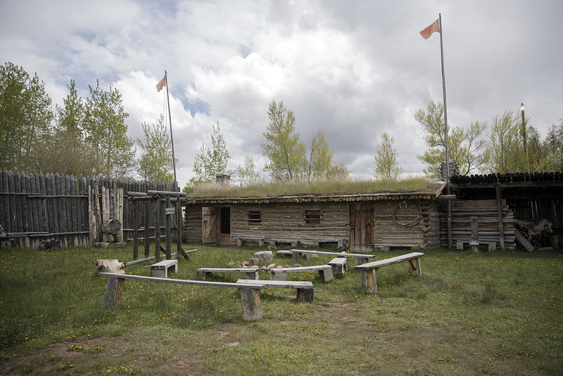
    <summary type="html"><![CDATA[<p><strong><em>“‘Fort Bridger’, as it is called, is a small trading-post, established and now occupied by Messrs. Bridger and Vasquez. The buildings are two or three miserable log-cabins, rudely constructed, and bearing but a faint resemblance to habitable houses.” – Edwin Bryant, American frontiersman and guide along the Overland trail</p></strong></p><img src="https://www.intermountainhistories.org/files/fullsize/4dbe8c195526e7485744bea72f784b0d.jpg" alt="Inside Stockade at Fort Bridger" /><br/><p>Located just off I-80, thirty miles from Evanston, Wyoming, lies the historic site of Fort Bridger. Fort Bridger has a long history of being involved with the American fur trade, western overland migration, and military involvement against the Mormons and Native Americans. It sits on the historic crossroads of the Oregon/California trail and the Mormon trail, and later the Pony Express Route, the Transcontinental Railroad, and the Lincoln Highway.</p><p>Fort Bridger was built by Jim Bridger in 1843. Bridger was a mountain man and frontiersman and heavily involved during the rendezvous fur trade period. He built his trading post close to popular rendezvous areas, as well as near the Oregon/California trail, hoping to gain business from the early emigrants heading towards Oregon and California. The original fort comprised of two log houses, about 40 feet long, with a corral for livestock. The fort also had a blacksmith shop, which was valuable for emigrants on the trail. While it was not as luxurious as Fort Laramie, Fort Bridger was still a welcome sight for travelers used to wandering in the wilderness. </p><p>In 1847, the first of the Mormon pioneers passed through the area. Jim Bridger and the Mormons initially maintained a good relationship, but quickly dissipated when the Mormons, feeling that the prices were too inflated at the fort, built their own fort nearby. After a series of raids on the fort, Bridger and his business partner, Louis Vasquez, abandoned the fort and the Mormons moved in. Eventually Bridger sold the fort to the Mormons, although he later disputes that claim. Adding additional fortifications to the fort, such as stone walls, the Mormons continued to use the fort as a supply station for emigrants heading west. However, in 1857, the Mormons abandoned and burned the fort down when rumors that federal troops were marching towards Salt Lake City with orders to bring Brigham Young in line. The US army subsequently occupied the area, deeming it a good proximity for a military presence over the Mormons. </p><p>The 1859 military reservation boundaries stretched 20 miles east to west, and 25 miles north to south, creating a buffer between the fort and the Mormon settlements. The army rebuilt the stone structures, and added a large parade ground, barracks, and supply buildings. Like most military forts in the west, Fort Bridger did not have walls that surrounded the entire fort, instead, the buildings faced inward towards each other with the open parade grounds serving as the center of the fort. The US army operated the fort from 1857 to 1890, dealing with disputes between the Mormons and the local Native American tribes. In the early 1860’s, Fort Bridger became the home to the Fort Bridger Indian Agency, which served the Eastern Shoshone, and parts of the mixed Bannock and Shoshone tribes. After the end of the Indian Wars in 1890, the military officially closed and abandoned the fort. Jim Bridger’s dream of a trading post became much more; Fort Bridger became the crossroad in the west, bridging the gap between the east and the west, political disputes, and white settlers and Native Americans. </p><p><em><strong><a href="https://www.intermountainhistories.org/items/show/243">For more (including 5 images) view the original article</a></strong></em></p>]]></summary>
    <published>2019-01-11T23:43:53+00:00</published>
    <updated>2026-04-17T19:32:03+00:00</updated>
    <link rel="alternate" type="text/html" href="https://www.intermountainhistories.org/items/show/243"/>
    <id>https://www.intermountainhistories.org/items/show/243</id>
    <author>
      <name>Rachel Hendrickson, Brigham Young University </name>
    </author>
  </entry>
  <entry>
    <title type="html"><![CDATA[Fort Boise&#039;s Historic Transitions]]></title>
    <summary type="html"><![CDATA[<p><strong><em>During the nineteenth century, the Boise Basin hosted an abundance of natural resources. These resources, specifically furs and gold, attracted settlers from the East, triggering a massive migration out West. Settlers, miners, and fur traders traveled the nearby Oregon Trail. A series of fort locations were employed starting in 1834 near the confluence of the Boise and Snake Rivers to provide support and stimulate economic growth by enabling settlers to trade goods with each other and nearby Native tribes. </em></strong></p><img src="https://www.intermountainhistories.org/files/fullsize/62d23d4b423fe9a0d3055e24e29e6bdf.jpg" alt="Fort Boise 2" /><br/><p>Snake Fort, founded in 1834 by Thomas McKay of the Hudson Bay Fur Trading Company, was originally located at the confluence of the Snake and Boise River near present-day Parma, Idaho, at the Oregon border. Later renamed Fort Boise, the fur trading post directly competed with Fort Hall, established by Nathaniel Wyeth, upriver in what is now present-day Pocatello, Idaho. The adobe style structure was highly susceptible to flooding, and Fort Boise was relocated several times within the general vicinity to reduce flooding risk. Within a few years, regional fur trading sharply declined, and the economy of Fort Boise transitioned to salmon fisheries. The great flood of 1853, along with escalating conflicts among settlers and Native Americans in 1854, contributed to its demise. The old fort was abandoned in 1855. </p><p>The new Fort Boise, situated in the heart of downtown Boise, Idaho, was established as a military post by the U.S. government in 1863 under the guidance of Major Pinkney Lugenbeel. Gold mining prevailed in the Boise Basin, and the military post provided a protective buffer to settlers and miners, reducing conflicts between them and surrounding tribes. Inspiration for the design came from brick buildings in Walla Walla, Washington, where Major Lugenbeel stopped on his way to the Boise Basin. Charles May, the builder responsible for the construction of the brick buildings, was hired to assist in the construction of Fort Boise. He used strong materials that consisted of brick and sandstone quarried from the nearby foothills and Table Rock.</p><p>In 1879, Fort Boise was renamed the Boise Barracks and served as a military base and a community center by hosting numerous social events such as theatrical performances, religious services, concerts, balls, tea and dinner parties, dancing, and tennis matches. The fort played a vital role in establishing the city and providing a center for diverse activities, meeting the needs of military and civilian. In the early twentieth century, the decision by the U.S. War Department to reduce small military bases and forts resulted in the fort’s second abandonment. Following several years of vacancy, Governor D.W. Davis loaned the property to the U.S. Public Health Service, enabling World War I veterans to receive treatments from postwar injuries. Passed in 1922, the Hospital Bill qualified veterans to receive medical treatments regardless of active status. The Public Health Service later turned the hospital over to the Veterans Bureau and in 1930 to the Veterans Administration. </p><p>Despite its many shortcomings, Fort Boise became a fundamental component to the development of the current city. Initially facilitating economic growth and prosperity in the region through the trade of natural capital, the fort later transitioned to a protective force, a location for social interaction among settlers and finally a place of healing for the wounded.</p><p><em><strong><a href="https://www.intermountainhistories.org/items/show/174">For more (including 8 images) view the original article</a></strong></em></p>]]></summary>
    <published>2018-05-17T00:07:10+00:00</published>
    <updated>2026-04-17T19:32:02+00:00</updated>
    <link rel="alternate" type="text/html" href="https://www.intermountainhistories.org/items/show/174"/>
    <id>https://www.intermountainhistories.org/items/show/174</id>
    <author>
      <name>Zachary A. Sanchez, University of Idaho</name>
    </author>
  </entry>
  <entry>
    <title type="html"><![CDATA[Lake Pend Oreille: Booming Industries and Depleting Resources]]></title>
    <summary type="html"><![CDATA[<p><strong><em>The last domesticated region in Idaho, known as Lake Pend Oreille, contains a long history of human activity. Pend Oreille’s first inhabitants include indigenous peoples followed by fur traders, explorers, miners, and loggers. The lake received its name from Canadian fur trapper and mapmaker David Thompson. The words “Pend Oreille” are French for “an ear pendant” or “hangs from ears”, possibly referring to the lakes shape or the jewelry worn by the Kalispel Indians who resided there. </em></strong></p><img src="https://www.intermountainhistories.org/files/fullsize/14e0b562f8c4bad39231ac3a23bec93f.jpg" alt="Pend d&#039;Oreille Lake" /><br/><p>In the fall of 1809, a fur agent with the North-West Company named David Thompson found Lake Pend Oreille. Thompson recognized the environmental value the area held.  Years after making the discovery, he wrote in his memoir, “The impression of my mind is, from the formation of the country and its climate, its extensive Meadows and fine forests, watered by countless brooks and Rills of pure water, that it will become the abode of civilized Man, whether Natives or other people.” Soon after his arrival, Thompson established a fur-trading outpost called the Kullyspell House. It was the first permanent wooden structure in Idaho next to Lake Pend Oreille and was named after the Kalispel Indians who guided Thompson around the Columbia River Basin. Once Thompson succeeded with his trading house, he moved on to other adventures, leaving Finan McDonald in charge. The location was forgotten until 1928 when a group of Idaho historians were guided by a blind Kalispel man to the remains of the trading outpost on the lake. </p><p>Lake Pend Oreille’s history did not end with Thompson and the Kullyspell House; the area grew over the next two hundred years. With the beginning of the gold rush era in 1866, the lake served as a passage for miners traveling from the Columbia River to Helena, Montana. With the ending of one boom comes the beginning of another. The demand for timber reached North Idaho, one of the largest areas of timber in the United States. The industry began in 1880 when Robert Weeks opened a general store dealing furs in the lake’s largest community, Sandpoint, in the panhandle of Idaho. As the town expanded so did the timber industry, along with the establishment of several sawmills, including the world-class Humbird Mill. The mill sparked modernization in the little lake town. By 1920, Sandpoint became the largest shipper of cedar poles and pilings in the Northwest. </p><p>The towns’ populations grew as the industries surrounding the lake attracted people from all over the country. Today, the location is featured in the media as one of the last, best places to live, but with its discovery came the chopping of its meadows and forests. This was followed cultivation and logging, which caused pesticides and other chemicals to drain into the lake. Just as David Thompson stated in his memoir, Lake Pend Oreille did become an abode for man and suffered from the exploitation of its abundant resources along with pollution from its inhabitants.</p><p><em><strong><a href="https://www.intermountainhistories.org/items/show/171">For more (including 3 images) view the original article</a></strong></em></p>]]></summary>
    <published>2018-05-16T01:42:20+00:00</published>
    <updated>2026-04-17T19:32:02+00:00</updated>
    <link rel="alternate" type="text/html" href="https://www.intermountainhistories.org/items/show/171"/>
    <id>https://www.intermountainhistories.org/items/show/171</id>
    <author>
      <name>Madison Huck, University of Idaho</name>
    </author>
  </entry>
  <entry>
    <title type="html"><![CDATA[Utah’s First Methodist Pioneer - Jedediah Strong Smith]]></title>
    <summary type="html"><![CDATA[<p><strong><em>Said to have been the first great protestant missionary to mountain men, “Bible Totin' Jed Smith” holds a special place in the memory of the Methodist community of Utah. </em></strong></p><img src="https://www.intermountainhistories.org/files/fullsize/7b138a6554c82831c59ac1c0b4ce33a7.jpg" alt="Jedediah Smith" /><br/><p>Early American Methodism and the exploration of the American West share a common pioneering ancestor in Jedediah Smith. While many of the commonly held beliefs about Jedediah Smith’s religious background and affiliation would require the support of more historical documentation than is currently available, Jedediah Smith’s life and subsequently developed popular legend provide an influential look into how the early nineteenth century explorer helped forge a future for the development of Utah and as a result, the Methodist Community that reveres the formidable mountaineer, appropriately referred to as “Bible Totin’ Jed Smith.”</p><p>Jedediah Strong Smith, Jr. was born on January 6, 1799 in Jericho, New York (present-day Bainbridge) to Jedediah Smith, Sr. and Sally Strong. The Smith family had early Puritan roots in the Samuel Smith family, which immigrated to the Massachusetts Bay Colony from Hadleigh, England in 1634. Jedediah Smith, Sr. became associated with the Wesleyan movement in the 1790s, tying the Smith family to the Methodist Church. It was a new movement, having just been developed in the 1780s in America by John and Charles Wesley. Though tempted to consider a life in the ministry, Jedediah Smith, Jr. chose to pursue a career as a trapper, frontiersman, and explorer. However, due to the revivalist fervor of the Second Great Awakening, Jedediah undoubtedly was shaped by his upbringing in the Methodist faith, influencing his actions and worldview throughout his short life. </p><p>Jedediah Smith’s contributions to early nineteenth-century exploration of the American West are well known and many. He was the first Anglo-American to make his way to California directly overland as well as the first to make an overland journey through northwest California into Oregon, a remarkable feat considering the densely forested landscape. Further, he was the first American to traverse the length of the Pacific Coast, ranging from San Diego in the South to Vancouver in the North. Smith was among the first to pass over the Sierra Nevada Mountains, and the first Americans to journey across the length and width of Utah. In 1826, he trekked into the Salt Lake and Utah Valleys, being the first American explorer to step foot south or west of the Great Salt Lake. Smith met a young and untimely death in a conflict with Comanche Indians in Kansas on May 27, 1831. Many of Jedediah Smith’s biographers note that he was a pious, sober, and God-fearing man. While Smith’s explorations in the West kept him from any form of regular or intermittent church attendance, he is known to have regularly devoted himself to the reading of the Bible. In fact, at the time of his death, Jedediah Smith’s estate contained a modest collection of books, two of which likely traveled with him during his career: The Holy Bible and a book of Methodist hymns. Today the Utah Methodist community reveres the memory and legend of Jedediah Smith as a pioneer of both their home state and faith. First United Methodist in Salt Lake City proudly displays a portrait of Jedediah Smith as a part of the faith’s community in the Great Basin. </p><p><em><strong><a href="https://www.intermountainhistories.org/items/show/152">For more (including 3 images) view the original article</a></strong></em></p>]]></summary>
    <published>2018-05-02T22:11:31+00:00</published>
    <updated>2026-04-17T19:32:01+00:00</updated>
    <link rel="alternate" type="text/html" href="https://www.intermountainhistories.org/items/show/152"/>
    <id>https://www.intermountainhistories.org/items/show/152</id>
    <author>
      <name>Nicholas B. Shrum, Brigham Young University</name>
    </author>
  </entry>
</feed>