<?xml version="1.0" encoding="UTF-8"?>
<feed xmlns="http://www.w3.org/2005/Atom">
  <title type="text">Intermountain Histories</title>
  <updated>2026-04-17T19:32:16+00:00</updated>
  <generator uri="http://framework.zend.com" version="1.12.20">Zend_Feed_Writer</generator>
  <link rel="alternate" type="text/html" href="https://www.intermountainhistories.org/"/>
  <link rel="self" type="application/atom+xml" href="https://www.intermountainhistories.org/items/browse?output=rss2"/>
  <id>https://www.intermountainhistories.org/</id>
  <author>
    <name>Intermountain Histories</name>
    <uri>https://www.intermountainhistories.org</uri>
  </author>
  <link rel="hub" href="https://pubsubhubbub.appspot.com/"/>
  <entry>
    <title type="html"><![CDATA[Frontier No. 1 Mine and the Explosion that Rocked Kemmerer, Wyoming]]></title>
    <summary type="html"><![CDATA[<p><strong><em>Kemmerer, Wyoming has been a mining town for over a century. In 1923, an explosion from the Frontier No.1 mine rocked the town and killed 99 men. Not only did this event leave many fatherless and widowed, but it also represented the dangers of industrialism in the early 20th century. </em></strong></p><img src="https://www.intermountainhistories.org/files/fullsize/d5a639434211920e5755e69130230de8.jpg" alt="A Brick of the Mine" /><br/><p><span style="font-weight:400;">The Kemmerer mine explosion is memorialized in a mural in the neighboring community of Diamondville. The mural is separated into several different sections and tells the history of mining in Lincoln County, Wyoming, ending with the tragic explosion in 1923. The city of Kemmerer decorates the miners’ graves every Memorial Day with  commemorative flowers. At the local museum, exhibits tell the stories of the many mines in the area, including Frontier No. 1.  </span>
<span style="font-weight:400;">John Kemmerer and Patrick J. Quealy formed a partnership that grew into four companies, including the mine. The mine opened in 1887, a mile outside of Kemmerer. For nearly a decade, the mine had no name until 1897, when Kemmerer dubbed the mine Frontier,  the same name as their supply company. At the time of the explosion, the mine produced up to 700 tons of coal a day. It also contained 30 workable areas. </span>
<span style="font-weight:400;">On August 14, 1923, Frontier No. 1 exploded and killed 99 men, the second-worst mining disaster in Wyoming history. A fire boss had tried to relight the flame of a safety lamp and accidentally ignited some nearby gas. It exploded and trapped the workers as the exits filled with rock and other debris. If the miners didn’t die from the initial explosion, then smoke or suffocating gasses, known as black damp, soon overtook them. It took 48 hours for rescuers to find the first survivors. The explosion made newspapers all over the state and became a symbol of the dangers of industrialism. Most of the men that died in the accident were immigrants from places such as South America, Italy, Japan, Australia, and Mexico. The </span><i><span style="font-weight:400;">Rock Springs Rocket</span></i><span style="font-weight:400;"> newspaper called the miners, "Martyrs to Industrialism."  The mine started back up after six months only to be shut down three or four years later. Today, the mine is buried to keep the public safe, but evidence of the explosion and the existence of the mine remains.</span></p><p><em><strong><a href="https://www.intermountainhistories.org/items/show/738">For more (including 4 images) view the original article</a></strong></em></p>]]></summary>
    <published>2023-04-07T17:30:44+00:00</published>
    <updated>2026-04-17T19:32:16+00:00</updated>
    <link rel="alternate" type="text/html" href="https://www.intermountainhistories.org/items/show/738"/>
    <id>https://www.intermountainhistories.org/items/show/738</id>
    <author>
      <name>Madison D. King, Brigham Young University</name>
    </author>
  </entry>
  <entry>
    <title type="html"><![CDATA[The Big Burn of 1910]]></title>
    <summary type="html"><![CDATA[<p><strong><em>The summer of 1910 was very dry in the northwest United States, with absolutely no precipitation May through July. The resulting fire was so destructive that Americans named it “the Big Burn.”</em></strong></p><img src="https://www.intermountainhistories.org/files/fullsize/1aac363c55b106acdcbdfdad043cc9a0.jpg" alt="Scars of Wallace, ID" /><br/><p>In the summer of 1910, every step through the forests in the Bitterroot Mountains between Idaho and Montana could meet with a resounding <em>crunch</em> from the arid twigs and leaves. The season had been extremely dry, with no rain at all from May through July.
On the night of July 26, a lightning storm swept across the Bitterroots. Thunder roared through the valleys, but there was no rainfall. By the following morning, nearly a thousand fires had sprung up around the region, sparked by the lightning. In the following weeks, even more blazes emerged. Sparks, thrown by trains rumbling through the dense forest had no trouble lighting the desiccant woodland, adding to the crisis. By the middle of August, there were 2,500 separate fires burning in Idaho and Montana.
On the morning of August 20, a breeze picked up through the Coeur d’Alene National Forest and the St. Joe Mountains. The wind gradually intensified throughout the day. Before the firefighters knew it, they were dealing with gusts of up to 70 mph. Hurricane-like winds pushed together hundreds of fires. By this point, there was virtually no hope of containing the fire. The Big Burn had started.
The dry wilderness was like an endless source of fuel, and he giant blaze devoured everything in its path. Flaming trees were pulled from the ground and tossed like mere sticks while dry timber caught fire and instantly exploded into a ball of sparks. Firefighters that survived reported that it was near impossible to outrun the heat because the inferno moved at the speed of a charging horse. Those with a head start had a chance of survival; most others did not. Over the course of two days, the Big Burn torched three million acres of land. A third of Wallace, Idaho—a town of three thousand people—burned to the ground. The fire almost completely leveled the mining towns of Grand Forks, Idaho and Taft, Montana. Eighty-six people died, seventy-eight of whom were firefighters.
It was soon clear that the Big Burn was the most destructive fire the United States Forest Service had ever seen. The fire would also be recognized as the most significant wildfire emergency because of its deep impact on future forest policies. The disaster inspired a wave of priority and policy concerning national land. The incredible loss of life and forest showed the Forest Service needed serious recognition from the people. Donations poured in, and Congress doubled the organization’s budget. Parks and forest stations hired more staff and established resources in preparation of another wildfire catastrophe. The disaster of 1910 imprinted on the nation how dangerous fire could be; it was a lesson learned at incredible human cost.</p><p><em><strong><a href="https://www.intermountainhistories.org/items/show/623">For more (including 5 images) view the original article</a></strong></em></p>]]></summary>
    <published>2022-06-25T06:54:15+00:00</published>
    <updated>2026-04-17T19:32:13+00:00</updated>
    <link rel="alternate" type="text/html" href="https://www.intermountainhistories.org/items/show/623"/>
    <id>https://www.intermountainhistories.org/items/show/623</id>
    <author>
      <name>Brennen Donahue, College of Idaho</name>
    </author>
  </entry>
  <entry>
    <title type="html"><![CDATA[Lewis Building]]></title>
    <summary type="html"><![CDATA[<p><strong><em>Built as a warehouse and rented out for concerts and parties, the Lewis Building was ultimately Brigham Young Academy’s first long-term schoolhouse, from 1876 until its destruction in a fire in 1884.</em></strong></p><img src="https://www.intermountainhistories.org/files/fullsize/2ce9c3a2d1095d395ee4b624f9eb5d6f.jpg" alt="BYU students at Lewis" /><br/><p><span style="font-weight:400;">Before there was a </span><a href="https://www.intermountainhistories.org/items/show/2?tour=12&index=0"><span style="font-weight:400;">Brigham Young Academy</span></a><span style="font-weight:400;"> (BYA) </span><a href="https://www.intermountainhistories.org/items/show/555"><span style="font-weight:400;">Building at Academy Square</span></a><span style="font-weight:400;">, BYA’s first schoolhouse was the Lewis Building (or Lewis Hall, evidently named after J.W. Lewis, who leased it from Brigham Young, president of The Church of Jesus Christ of Latter-day Saints). The Lewis Building was originally built as a warehouse and used as an amusement hall, but it became a place of learning when brothers Warren and Wilson Dusenberry rented it as an expansion to their “second Dusenberry school” in 1869.</span>
<span style="font-weight:400;">By the summer of 1870, the University of Deseret took notice of the Dusenberry school and incorporated it as the Timpanogos Branch of the University of Deseret. Young, who owned the Lewis Building, was keenly interested in the school’s success. When the Dusenberrys struggled to make ends meet, Young often waived their rent.</span>
<span style="font-weight:400;">Starting in 1873, however, the Timpanogos Branch began buckling under financial hardship. Rent prices rose while enrollment stagnated, and the Dusenberries had to take on extra jobs to keep themselves afloat while the Timpanogos Branch struggled. In the spring of 1875, the Timpanogos Branch closed completely.</span>
<span style="font-weight:400;">However, Young turned the closure into a new beginning. Having contemplated establishing a school in Provo for years, Young deeded the Lewis Building as a home for a new institution, Brigham Young Academy, and he hired Warren Dusenberry as a principal and Wilson Dusenberry as a teacher. The Lewis Building underwent repairs for the remainder of 1875. Brigham Young Academy opened for its first term in January 1876. Warren resigned as principal in April, and Karl G. Maeser replaced him as the Academy’s first long-term principal.</span>
<span style="font-weight:400;">Although the young Brigham Young Academy now fully controlled the Lewis Building, it still struggled to keep financially afloat. Young’s deed voided rents as a burden, but enrollment was still down; in August 1876, BYA started its fall term with only ninety-seven students and about $100 in its balance. To stay solvent, BYA rented rooms for parties and concerts, even during school hours, which interrupted students’ studies. A year later, in August 1877, Young died, leaving it up to trustees to manage BYA.</span>
<span style="font-weight:400;">Yet the longer BYA survived, the more it thrived. In 1878, the school’s Academic Department, the only department for older students, split into four: Language, Polytechnical, Commercial (these three were taught at a high school level), and Scientific (for even more advanced students). In the late 1870s, BYA also organized a Normal Department, for teacher training. By 1880, over 300 students were enrolled, and in 1881, BYA awarded its first collegiate diploma to James E. Talmage, the future apostle-scientist.</span>
<span style="font-weight:400;">Tragedy struck when a fire destroyed the Lewis Building in 1884, leaving BYA without a schoolhouse. Reed Smoot, future apostle-senator, recalled saying to Principal Maeser, “Oh, Brother Maeser, the academy has burned.” Maeser rebuffed Smoot’s dismay. “No such thing,” Maeser said. “It’s only the building.”</span>
<span style="font-weight:400;">BYA worked quickly to borrow and rent rooms for classroom use, and it lost only a day of classes, reconvening on Tuesday in whatever spaces could be secured in buildings around Provo. BYA was homeless until a new structure was built in 1892.</span>
<span style="font-weight:400;">The Lewis Building was gone, but Brigham Young Academy—now University—lived on. In recognition of the Lewis Building’s legacy, in 2004, This Is the Place Heritage Park built its Smoot Hall building as a replica of the original Lewis Building, BYA’s first home.</span></p><p><em><strong><a href="https://www.intermountainhistories.org/items/show/567">For more (including 6 images) view the original article</a></strong></em></p>]]></summary>
    <published>2022-02-24T12:32:00+00:00</published>
    <updated>2026-04-17T19:32:12+00:00</updated>
    <link rel="alternate" type="text/html" href="https://www.intermountainhistories.org/items/show/567"/>
    <id>https://www.intermountainhistories.org/items/show/567</id>
    <author>
      <name>Makoto Hunter, Brigham Young University</name>
    </author>
  </entry>
  <entry>
    <title type="html"><![CDATA[Sunshine Mine Disaster]]></title>
    <summary type="html"><![CDATA[<p><strong><em>On May 2, 1972, the Sunshine Mine experienced a devastating fire. Claiming the lives of seventy-one men, the Sunshine Mine Disaster is considered one of the worst mining disasters in Idaho’s history.</em></strong></p><img src="https://www.intermountainhistories.org/files/fullsize/a74eff8e5bddf88d0b3807cc81cc5f79.jpg" alt="Sunshine Miners Memorial" /><br/><p>The fire at the Sunshine Mine, a silver mine near Kellogg, Idaho, was first reported at about 11:40 pm after an electrician smelled smoke and warned the foreman. The foreman telephoned down to the mechanics, who were in a work room, and asked them to see where the fire was burning. When they decided to head to another tunnel to search, they found it so filled with smoke they could not enter; when they moved toward an adjacent tunnel, they found it was also filled with smoke. Simultaneously, the shaft foremen requested had the warning system activated, alerting miners to the presence of gas, and sent oxygen masks into the mine. Most of the men became aware of the fire when the smoke entered their workplaces, which they retreated from by moving toward another part of the shaft. There, miners hoisted men up to the surface. This continued until about 1:00 PM when the miner manning the lift was overcome by gas and smoke. Men on the lower levels were stuck, and while many tried to make it to where men were being hoisted to the surface or at least barricade themselves against the gas, most died from carbon monoxide exposure.
While the surviving miners and surface workers mounted their own rescues, they also called in trained rescue teams. In order to reach the bottom of the mine, rescuers and workers needed to use mine hoists to travel up and down the shafts, and that required repairing the electical system. However, with so much gas and smoke, the crew could work only for as long as their oxygen tanks lasted, about two hours at a time. With so little time, rescuers chose to focus on finding survivors rather than removing the bodies, and they forced themselves to walk past and over the bodies of asphyxiated miners every time they made the trip to the repair site. In total, eighty escaped the mine, only two survived the disaster while inside the mine, and ninety-one died.
The exact reason and location for the fire is unknown. Because the fire damaged walls and support beams, the mine partially collapsed, burying areas that might have provided clues. The Sunshine Mine’s high profile fire significantly impacted discourse surrounding the safety of hard rock mining. This disaster prompted Congress to pass the Federal Mine Safety and Health Act of 1977, improving safety standards for hard rock mining. For example, the act required mines to provide more ventilation and to create plans for guiding surface workers’ response in the event of another disaster. The act also stipulated mandatory disaster training so all miners knew what to do and where to go in an emergency, and it required miners have personal oxygen tanks with them at all times. Overall, the act created a safer work environment to help prevent similar disasters in the future.</p><p><em><strong><a href="https://www.intermountainhistories.org/items/show/539">For more (including 4 images) view the original article</a></strong></em></p>]]></summary>
    <published>2021-11-13T22:39:10+00:00</published>
    <updated>2026-04-17T19:32:11+00:00</updated>
    <link rel="alternate" type="text/html" href="https://www.intermountainhistories.org/items/show/539"/>
    <id>https://www.intermountainhistories.org/items/show/539</id>
    <author>
      <name>Megan Wagner, Northern Arizona University</name>
    </author>
  </entry>
  <entry>
    <title type="html"><![CDATA[Castle Gate Mine Disaster]]></title>
    <summary type="html"><![CDATA[<p><strong><em>The Castle Gate Mine Disaster was a horrific tragedy that took the lives of 171 men. Considered the second-worst mining disaster in Utah’s history, the disaster is well remembered not only for the death toll but also for the push for safety reform in its aftermath.</em></strong></p><img src="https://www.intermountainhistories.org/files/fullsize/3addcc19e4ca5cf2966b852500df227f.jpg" alt="Mass funeral" /><br/><p>On March 8, 1924, in Castle Gate, Utah, two explosions rocked the local coal mine, killing all 171 men working at the time. Both explosions happened when men ignited carbon monoxide while trying to relight their lamps. First, a boss investigating some methane gas near the roof of a mineshaft. When his lamp went out, he tried to relight it, but his match ignited the gas, which in turn ignited coal dust, setting off a huge explosion. Those who survived this first explosion found themselves plunged into darkness, as the blast blew out their lamps. When these survivors attempted relighting their lamps, they set off another explosion.
Rescue workers faced severe challenges when they entered the mine to look for any possible survivors. The passageway was covered with debris and badly damaged. It made the passageway incredibly difficult to traverse and slowed them down. The mine was also filled with gas, which made it deadly for the rescue workers. One rescuer died when another knocked off his oxygen clip; within a few minutes, he breathed in too much gas and perished. When the workers found the bodies, many were badly burned and mutilated. Because of huge number of deaths, bodies were buried soon after identification.
Most of the men were married with children, leaving behind many widows and children without fathers. In the days after the disaster, the Red Cross along with women from other parts of came to offer aid to the families. They cooked meals, tended to children, and even sewed mourning clothes for the community. The families of the miners were devastated; in addition to losing a husband and father, they also lost their primary financial provider. Although the families did receive compensation, many left Castle Gate to go live with relatives. Those who stayed received aid from a Red Cross committee that provided food, clothes, and anything else the families might need. The relief committee continued to distribute aid until 1936, ultimately dispersing $132,145 worth of relief.
The mine eventually reopened with increased safety measures. The Utah Fuel Company, which owned the mine, met with the state government to review safety laws and create new amendments and resolutions to make the mines safer. This included more funding for mine inspectors, mandates about clearing dust created from rock mining, prohibiting moving methane gas while men were working in the mine, and requiring coal dust be cleaned from abandoned rooms. Though these new procedures did not completely stop other disasters, they did greatly improve the safety of the mines.</p><p><em><strong><a href="https://www.intermountainhistories.org/items/show/538">For more (including 3 images) view the original article</a></strong></em></p>]]></summary>
    <published>2021-11-13T22:04:12+00:00</published>
    <updated>2026-04-17T19:32:11+00:00</updated>
    <link rel="alternate" type="text/html" href="https://www.intermountainhistories.org/items/show/538"/>
    <id>https://www.intermountainhistories.org/items/show/538</id>
    <author>
      <name>Megan Wagner, Northern Arizona University</name>
    </author>
  </entry>
  <entry>
    <title type="html"><![CDATA[White Ash Mine Disaster]]></title>
    <summary type="html"><![CDATA[<p><strong><em>A flood in the White Ash Mine, located in Colorado, killed ten men. Though not the worst mining disaster in Colorado history, the White Ash Mine disaster is remembered for a mysterious fire that thwarted an attempt to rescue the drowned miners.</em></strong></p><img src="https://www.intermountainhistories.org/files/fullsize/319b9bf4fa97e5419ff9cdd0e0e32404.jpg" alt="The mine and her miners" /><br/><p>On September 9, 1889, at about four o’clock in the afternoon ten men drowned in the White Ash Mine, a coal mine near Golden, Colorado. An engineer, Charles Hoagland, was the first to discover that something had happened. He had attempted to send down the elevator, but it wouldn’t go to the bottom, and then it wouldn’t rise. Hoagland attempted to contact the cage man who was at the bottom of the mine, but he did not respond. Hoagland phoned the foreman, Evan Jones. When Jones descended into the mine, he heard the roaring of water. Realizing the mine was flooding, he informed the general manager and gathered other men in an attempt to rescue the men trapped below. However, they were only able to travel about 300 feet down before they were hit with bad air and retreated. Around midnight, the mine inspector, John McNeil, and the general manager, Paul Lanious, descended into the mine.
They found out the mine, which was about 780 feet deep, was filled with CO2. The water had reached 140 feet high and was scalding hot at about 115 degrees Fahrenheit. At about 280 feet down, they felt a strong heat coming out of the walls; when they examined the area, they found that a portion of this level was on fire. The fire was getting closer to the shaft timbers, making it impossible to isolate the fire and put it out. McNeil and Lanious made it about 400 feet down before the gas became too much, forcing them to ascend.
As a result of the fire, the gas, and the height of the water, officials concluded the men could not have survived. With the mine considered too dangerous, officials suspended extraction efforts and instead sealed off the shaft. Their decision entombed the men in the mine.
In the aftermath, people wondered that had caused the disaster. Investigation revealed the most likely culprit was the Loveland Mine, attached to the White Ash Mine through coal veins. About ten years before the White Ash Mine flood and fire, the Loveland Mine had itself shut down due to flooding. Over the years, the underground
The biggest question that everyone had was what caused the disaster. The culprit was found to be the Loveland Mine which was attached to the White Ash Mine through coal veins. The Loveland Mine had been closed about ten years before the disaster on account of flooding. While White Ash passed inspections, showing no signs of potential flooding, over the years the coal walls separating Loveland and White Ash degraded. When they finally broke down, the floodwaters still inside Loveland poured into White Ash.
While the precise reasons the coals walls degraded is not known for certain, most people believe an underground fire had smoldered inside Loveland and slowly ate away at the coal separating the two mines. In fact, McNeil had discovered a smoldering fire between the walls a few years earlier, though he had it sealed up. However, there may have been a second fire that went unnoticed. This unchecked fire made the walls crumble, allowing the Loveland Mine’s water to drain into the White Ash.</p><p><em><strong><a href="https://www.intermountainhistories.org/items/show/537">For more (including 4 images) view the original article</a></strong></em></p>]]></summary>
    <published>2021-11-13T21:37:47+00:00</published>
    <updated>2026-04-17T19:32:11+00:00</updated>
    <link rel="alternate" type="text/html" href="https://www.intermountainhistories.org/items/show/537"/>
    <id>https://www.intermountainhistories.org/items/show/537</id>
    <author>
      <name>Megan Wagner, Northern Arizona University</name>
    </author>
  </entry>
  <entry>
    <title type="html"><![CDATA[Smith Mine Disaster]]></title>
    <summary type="html"><![CDATA[<p><strong><em>The Smith Mine Disaster was the worst coal disaster in the state of Montana. It claimed the lives of seventy-five people and destroyed the mining industry of Bearcreek which had been built around it.</em></strong></p><img src="https://www.intermountainhistories.org/files/fullsize/491a3bb779af0871cc256249ca6bbe49.jpg" alt="Smith Mine Disaster memorial" /><br/><p>On February 27, 1943, Bearcreek, Montana experienced what remains the worst coal disaster in the state. A combination of carbon monoxide and methane gas created an explosion killing seventy-four of the seventy-seven men working in the mine. The three men to survive were in the mine but did not see the explosion. However, they described feeling a pressure on their ears but hearing nothing before being blasted with air. One of the men rushed to the phone to let the men on the surface know that something was wrong but before he could he was overcome with gas. The other two men were attempting to escape the mine when they were knocked to their feet by the blast of air and then fell unconscious from the gas.
The explosion knocked out the electricity, preventing the mine’s emergency system from sounding. However, other mines in the area sounded theirs, alerting the other miners as well as those in the town that something was wrong in Smith Mine.
Men came from adjacent mines and from the town to rescue the men still trapped. Rescuers who went into the mine faced serious danger from the combination of carbon monoxide and methane gas. The farther anyone went into the mine, the more the gas took a toll, with many tripping, falling, hallucinating, or becoming disoriented. One of the rescuers breathed in too much gas and died as a result.
The seventy-four men who died either died immediately in the blast or were killed by the gas.  The precise extent of the three survivors’ injuries is not documented in the sources, but they did spend a few days in the hospital.
The tragedy deeply affected the victims’ families. Family members spent sixty-three hours waiting to hear what had happened and get updates about their family members. The town was small, so virtually everyone there was a part of a mining family and thus knew or was related to someone who had died. The scale of the loss devastated the families, and many left Bearcreek afterwards because of their grief.
Bearcreek was small before and the disaster only made it worse. The mine closed permanently, and the town’s coal production fell. The biggest hit to the town’s economy and population came when the railroad ceased operating in 1953, ten years after the disaster. The railroad was the easiest way to ship coal, and with it closed, most of the mines followed suit, with the last mine closing in the 1970s. The Smith Mine disaster was effectively the beginning of the end for Bearcreek.</p><p><em><strong><a href="https://www.intermountainhistories.org/items/show/536">For more (including 4 images) view the original article</a></strong></em></p>]]></summary>
    <published>2021-11-13T11:42:54+00:00</published>
    <updated>2026-04-17T19:32:11+00:00</updated>
    <link rel="alternate" type="text/html" href="https://www.intermountainhistories.org/items/show/536"/>
    <id>https://www.intermountainhistories.org/items/show/536</id>
    <author>
      <name>Megan Wagner, Northern Arizona University</name>
    </author>
  </entry>
  <entry>
    <title type="html"><![CDATA[Granite Mountain/Speculator Mine Disaster]]></title>
    <summary type="html"><![CDATA[<p><strong><em>The Granite Mountain/Speculator Mine disaster is considered the worst hard-rock mine disaster in the United States, with 163 people dying as a result of the fire. The disaster is remembered both for its death toll as well as the strike that ensued following the fire. </em></strong></p><img src="https://www.intermountainhistories.org/files/fullsize/b27dced64868903650ec532263084c95.jpg" alt="Where there’s smoke" /><br/><p>The Granite Mountain/Speculator Mine disaster near Butte, Montana, began a little before midnight on June 8, 1917, as the result of a tragic but ironic accident. The North Butte Mining Company planned to install a sprinkler system in the 3,500-foot shaft of Granite Mountain to increase safety. The system was nearly complete when one of the last steps required moving an electrical cable that was 1,200 feet long and weighted three tons. While workers lowered the cable, it slipped and fell about a thousand feet down a mine shaft. The cable was ruined in the fall, as it had stripped away the cable’s lead sheathing, revealing the oil-soaked cloth insulation underneath. Workers left the cable in the shaft and reported the incident to the assistant foreman, Ernest Sullau.
Sullau and John Collins, a shift boss, went down to inspect the damages and locate the cable. Sullau carried a carbide-burning lantern, with an open flame, and as he walked around the shaft, he set a piece of cloth on fire. Surprised, he moved the lantern back away from the burn but inadvertently set another section of cloth on fire. Sullau stayed below while Collins went above to inform the engineers of the fire.
Although the fire burned extremely hot, few miners were burned. Instead, the fire’s smoke and gas was the true threat as it spread throughout the mine as well as into adjoining mines, asphyxiating Sullau and many miners. Firefighters worked for five days to contain the fire, and it took rescuers three days thereafter to get all the survivors out. Most of those who survived were treated for smoke and gas inhalation onsite and were able to go home; the few particularly bad but still living cases were rushed to the hospital. By the time the dust settled, the community counted 168 dead.
The fire was a breaking point for the workers in Butte. Left with no unions since 1914, they went on strike and created the Metal Mine Workers’ Union. However, Butte was one of the largest producers of copper, and due to World War I copper was in high demand. As a result of the need for copper, in August the federal government deployed troops to break the strike. With federal troops on the scene adding to mounting pressures against the miners, their strike ended in December.
The fire was also particularly difficult for the miners’ families. While compensation was available, it was only given to miners who had wives or children. Otherwise, the company was only obligated to pay $75 for funeral expenses. However, many of the unmarried miners were the sole providers to their elderly parents. Miners whose family members were either not U.S. citizens or not in the country also did not receive financial compensation. Overall, only 39 of the 163 families of the dead received any non-funeral financial compensation.</p><p><em><strong><a href="https://www.intermountainhistories.org/items/show/535">For more (including 4 images) view the original article</a></strong></em></p>]]></summary>
    <published>2021-11-13T10:53:02+00:00</published>
    <updated>2026-04-17T19:32:11+00:00</updated>
    <link rel="alternate" type="text/html" href="https://www.intermountainhistories.org/items/show/535"/>
    <id>https://www.intermountainhistories.org/items/show/535</id>
    <author>
      <name>Megan Wagner, Northern Arizona University</name>
    </author>
  </entry>
  <entry>
    <title type="html"><![CDATA[The Scofield Mine Disaster]]></title>
    <summary type="html"><![CDATA[<p><strong><em>On May 1, 1900, an explosion at the Winter Quarters mine killed at least 200 men. At the time, it was the worst mining accident to occur in the United States, and it devastated the families left behind in the mining town of Scofield.</em></strong></p><img src="https://www.intermountainhistories.org/files/fullsize/e97bda205bd88ea68ad598ea6aa80eb4.jpg" alt="Caskets at Wasatch Store, Winter Quarters, Utah" /><br/><p>Scofield is a small mining town located in Carbon County, located next to the Winter Quarters mine. On May 1, 1900, there was an accidental explosion in the Winter Quarters mine. While many men rushed to rescue miners caught in the blast, many were killed in the initial explosion, struck by falling debris, or killed by afterdamp, a toxic gas. Miners from other mines in the area, such as Castle Gate, Clear Creek, and Sunnyside, helped retrieve bodies the next day. A total of 200 - 246 men were killed in the accident. There were not enough coffins to bury all of the miners, so some coffins had to be ordered from Denver, Colorado and taken to Scofield on a train.</p><p>The Winter Quarters mine explosion had devastating effects on the town of Scofield. Nearly every family lost someone in the accident, with some families losing several family members. In a tragic example, the Louma family lost six sons and three grandsons, all in the same day. However, some incredible stories came from the disaster as well. One such story is that of John Wilson, who was blown 820 feet from the entrance of the mine into the surrounding canyon and miraculously survived. Another well-known story is that of Thomas Pugh, a 15-year-old boy who put his cap in his teeth, used it to plug his nose, and ran a mile and a half through toxic gas back to the mine entrance in the dark.</p><p>Although the exact cause of the explosion was never discovered, many believe that the accident could have been prevented if the Pleasant Valley Coal Company had implemented safety procedures and taken better precautions. Unsurprisingly, many families blamed the company for the accident. Labor unrest from this event no doubt contributed to later strikes in the region, such as the 1901 Pleasant Valley strike. The Winter Quarters mine puts into perspective how dangerous an occupation mining was, and how much miners were asked to sacrifice for their livelihood. Today, many remember the Scofield mining disaster as a horrible event that showcases the brutal treatment of working-class individuals in the 20th century.</p><p><em><strong><a href="https://www.intermountainhistories.org/items/show/389">For more (including 3 images) view the original article</a></strong></em></p>]]></summary>
    <published>2020-02-16T07:01:51+00:00</published>
    <updated>2026-04-17T19:32:07+00:00</updated>
    <link rel="alternate" type="text/html" href="https://www.intermountainhistories.org/items/show/389"/>
    <id>https://www.intermountainhistories.org/items/show/389</id>
    <author>
      <name>Abby Donaldson, Brigham Young University</name>
    </author>
  </entry>
  <entry>
    <title type="html"><![CDATA[The Gold King Mine Disaster: EPA’s “Help” Not Wanted ]]></title>
    <summary type="html"><![CDATA[<p><strong><em>After an accidental spill at Gold King Mine in 2015, Silverton residents resisted Superfund designation fearing it would negatively impact tourism in the area. </em></strong></p><img src="https://www.intermountainhistories.org/files/fullsize/a7c08f5be62c192ef0eaf31a5c578cb2.jpg" alt="Gold King Mine" /><br/><p>In 2015, the EPA hired private contractors to clear the entrance to the abandoned Gold King Mine outside of Silverton, Colorado. They sought to determine the mine’s impact on contamination of the nearby Animas River. There had been a steady trickle of highly acidic waste coming from the mine since its closure in 1991, but the workers were not expecting to find 3 million gallons of highly pressurized orange sludge waiting on the other side of a massive plug in the mine. Those present were fortunate to escape with their lives as the poisonous mixture flowed down the mountain, eventually draining into the Animas River. The river turned a murky orange and immediately a ban was placed on drinking or swimming in the water due to the high amounts of toxic lead and arsenic. Exactly one year after the disaster, the EPA placed the region surrounding Silverton on the superfund list, qualifying it for federal funding for clean-up efforts. Silverton had actually been fighting Superfund designation for over 20 years. Residents feared it would impact the region’s primary economic market - tourism.</p><p>Silverton has a history of defending itself. Concern over pollution was a century-old affair, but the people of Silverton vehemently defended their principal sources of income: mining and processing raw ore. In the early 20th century, residents of the downstream town of Durango were fed up with Silverton’s pollution. In 1902, the Durango Democrat complained, “There never was a word or sentence uttered against the purity and excellence of the Animas river water until Silverton, in open violation of the law, began using the stream for a dumping ground for garbage and mill tailings.” The Silverton Standard shot back, “The thing for Durango to do is employ its energy in providing a water supply from some of the many pure mountain streams[…] It certainly cannot afford to take any action that will annoy or embarrass the mining and milling of Silverton.” However, Silverton was also well accustomed to the economic booms and busts associated with mining. In response, the city had turned to tourism as early as the 1930s. The Animas River provided adventurous river rafting experiences, and the surrounding San Juan Mountains left visitors awestruck. When the last mines closed in the 1990s, tourism was the largest industry left in Silverton. </p><p>With the same passion that residents once defended their mines, they defended their reputation as a scenic mountain paradise. One lifelong Silverton resident remarked, “We’re a tourist area. You hear the word ‘Superfund’ site and 99 percent think ‘danger.’ So why would you want to go to a Superfund site?” It is not as though the people of Silverton are pro-pollution, for there is an organized community effort to clean up the Animas, but rather they are understandably committed to protecting what brings business into their town. Some residents blame the EPA for the leak, while others fault the Gold King Mine Company for the pollution in the first place; however, everyone in Silverton can agree that the EPA’s Superfund program is not welcome relief from environmental tragedy, but a death sentence on the town’s marketability as a popular destination. </p><p>The Animas River was deemed safe for drinking and recreational use weeks after the spill, though there are still consequences from the disaster. Today the EPA continues clean-up operations near Silverton and the site has grown to include 48 mines that risk contaminating groundwater. A water treatment plant was constructed in 2015, though according to the EPA, “migration of contaminated groundwater is not stabilized.” The impact of human exposure to the toxic waste is uncertain, but contaminated waste reached as far as New Mexico, Utah and the Navajo Nation, harming crops and livestock near the Animas and San Juan Rivers. Despite their initial misgivings towards the EPA and the Superfund program, the people of Silverton now work together with the federal government to clean-up the last mess and assure this never happens again. </p><p><em><strong><a href="https://www.intermountainhistories.org/items/show/380">For more (including 5 images) view the original article</a></strong></em></p>]]></summary>
    <published>2020-01-08T22:28:45+00:00</published>
    <updated>2026-04-17T19:32:07+00:00</updated>
    <link rel="alternate" type="text/html" href="https://www.intermountainhistories.org/items/show/380"/>
    <id>https://www.intermountainhistories.org/items/show/380</id>
    <author>
      <name>Sam Heywood, Brigham Young University</name>
    </author>
  </entry>
  <entry>
    <title type="html"><![CDATA[Tragedy at Church Rock: Superfunds and the Marginalization of Navajos]]></title>
    <summary type="html"><![CDATA[<p><strong><em>In 1979 the United Nuclear dam in New Mexico failed and released over 1,000 tons of radioactive waste, greatly harming the Navajo community at nearby Church Rock. </em></strong></p><img src="https://www.intermountainhistories.org/files/fullsize/24fb43a1f523a53719f4159e884c1d1d.jpg" alt="Church Rock Dam Breach" /><br/><p>Before sunrise on July 16, 1979, Navajos who resided in Church Rock, New Mexico, awoke to the sound of rushing water. They were confused, for there had been no rain to cause flooding of the nearby Puerco River. Unbeknownst to them, a nearby dam owned by United Nuclear had failed, releasing 95 million gallons of mine waste into the local water systems. This waste contained 1,100 tons of radioactive waste from a mill that processed uranium, killing sheep that drank it and burning the feet of children who waded in it. United Nuclear temporarily closed the mill and immediately the Indian Health Services urged people not to drink the water, but without assistance many poor families had no other options. Shortly after, the CDC tested the radiation levels of just six people, and when their results weren’t alarming, declared that no major threat to public health existed due to the spill. In spite of this, the Navajo Nation appealed to the state’s governor to declare a state of emergency in the Church Rock area, a request that was denied. However, when United Nuclear threatened to start laying people off if the mill remained closed, the state and federal government quickly complied to let mill operations resume just five months after the massive spill. The spill, and effects from the mill’s continued operation after, landed the Church Rock on the National Priority List for Superfund sites in 1983.</p><p>The neglect of Navajo lands is evident when one compares the response to another nuclear accident that happened just four months prior at Three Mile Island in Pennsylvania. A partial nuclear meltdown led to the evacuation of 140,000 people and to the state declaring a state of emergency, even though the release of nuclear radiation was significantly less than at Church Rock. Many government funded investigations were commissioned to understand the causes and the long-lasting effects of the accident in Pennsylvania, but such studies do not exist for the Navajo at Church Rock. The failure of United Nuclear’s dam was no mystery; cracks were reported in the 75-foot earthen structure nearly two years prior to the spill, but no action was taken. United Nuclear efforts to clean amounted to the removal of 3,500 tons of contaminated soil downstream, estimated to be just 1% of the total affected soil.</p><p>The site’s designation as a Superfund has hardly been effective at providing meaningful assistance. After 36 years as a Superfund, the EPA’s website still reports today that “groundwater contamination, and the migration of contaminated groundwater is not stabilized.” Many Navajos have long given up hope of government assistance. They have formed grassroots organizations like Eastern Navajo Diné Against Uranium Mining to prevent future mining operations and aid contaminated areas. In 2017, the ENDAUM discovered a small Navajo community was still using contaminated water to hydrate and bathe their livestock. They found hairless sheep and insides of cows that had turned yellow. The Navajo had to burn the sick animals to avoid further contamination. Even though there is a lack of scholarly investigation on the effects of the spill, the experiences of Navajo show the terrible consequences on local health. One Navajo remarked on the high cancer rates in the reservation: “That’s why we drink. We think we won’t live long.” This has negative implications for the future Navajo, as one resident of Church Rock commented, “Our generation is afraid of having children. Cancer runs in our family, but it shouldn't.” </p><p>Americans generally don’t view pollution positively, but the time of putting production and profits over human lives must end. The current presidential administration values economic potential over the environment and public health, a trend that does not bode well for the neglected Navajo. The Navajo Nation deserves the reparation that disasters like the Church Rock spill demand as well as protection from future exploitation. </p><p><em><strong><a href="https://www.intermountainhistories.org/items/show/379">For more (including 3 images) view the original article</a></strong></em></p>]]></summary>
    <published>2020-01-08T22:11:58+00:00</published>
    <updated>2026-04-17T19:32:07+00:00</updated>
    <link rel="alternate" type="text/html" href="https://www.intermountainhistories.org/items/show/379"/>
    <id>https://www.intermountainhistories.org/items/show/379</id>
    <author>
      <name>Sam Heywood, Brigham Young University</name>
    </author>
  </entry>
  <entry>
    <title type="html"><![CDATA[The Virginia City Great Fire of 1875<br />
]]></title>
    <summary type="html"><![CDATA[<p><strong><em>Considered one of Nevada’s fastest growing cities in its day, Virginia City quickly became a pile of rubble after an 1875 fire ravaged the city for nine hours, leaving more than 2,000 structures destroyed, and hundreds homeless.</em></strong></p><img src="https://www.intermountainhistories.org/files/fullsize/cfcb08d69c92c7d2a6bdf3030dd74e58.jpg" alt="Extinguishing flames on C Street" /><br/><p>Fire was feared throughout the West. Most boom towns were constructed of lumber since wood was cheaper, more accessible and easier to ship. However, this made towns major fire hazards. Virginia City battled several fires throughout its history, but the ‘Great Fire of 1875’ was the largest. On the morning of October 26, 1875 at 5:15am, a single lamp caused the biggest fire in the town’s history. The fire started on A Street in Kate Shea's boarding house when a lamp was accidentally knocked over, probably due to the rough, rowdy atmosphere. Within minutes, the fire consumed the dry timber, quickly burning the entire building. To make matters worse, nature intervened. The westerly wind, known as the “Washoe Zephyr,” began to fan and push the flames further into town.</p><p>The fire quickly consumed all buildings in its path. Reportedly, even the few buildings built with brick melted due to the intense heat. Several attempts were made to extinguish the flames, but to no avail. The volunteer fire companies tried to combat the fire, but their water hoses could not pump enough water to fight the flames. Even a bucket brigade did little good in competing with the large-scale fire. The greatest fear was the fire reaching the Consolidated Virginia and Ophir mine shafts. If the fire reached the mines, it could potentially cause extensive damages and leave most of the town jobless. As fire continued to destroy everything in its wake, the wind finally shifted in the afternoon, leaving only the southern end of town standing. By 2:00pm, most of the flames were extinguished, leaving behind only a memory in the charred remains of one of the largest cities in the Nevada. </p><p>The damage was severe. Over 2,000 structures were destroyed, including homes, churches, saloons, businesses, mills and other mining buildings. The burnt section of town spanned three-quarters of a mile long and half-a-mile wide. Over $1,000,000 was estimated in damages, causing stocks to drop overnight. Further problems arose as over three hundred people were left homeless and sought shelter in the only remaining public buildings standing, the school houses. Rioting began in the streets, causing city patrols to ask for additional help from the National Guard to protect still-standing property. The city also forced the remaining saloons to prohibit the sale of alcohol, trying to prevent further problems. The biggest concern was providing food, clothing, and shelter for the fire victims. </p><p>Luckily, immediate humanitarian relief was sent from California, providing food and clothing for the victims. The mines reopened the following day after the fire, since minimal damage to the shafts in the Ophir mine allowed miners to go back to work. Optimistic townspeople reported to newspapers that “the town will be all right in a week or two.” Although the total amount of money lost estimated to be almost $10,000,000, the townspeople proved to be resilient and the fire became just another minor setback in the rich history of the Comstock. </p><p><em><strong><a href="https://www.intermountainhistories.org/items/show/246">For more (including 4 images) view the original article</a></strong></em></p>]]></summary>
    <published>2019-01-12T01:21:47+00:00</published>
    <updated>2026-04-17T19:32:03+00:00</updated>
    <link rel="alternate" type="text/html" href="https://www.intermountainhistories.org/items/show/246"/>
    <id>https://www.intermountainhistories.org/items/show/246</id>
    <author>
      <name>Rachel Hendrickson, Brigham Young University</name>
    </author>
  </entry>
  <entry>
    <title type="html"><![CDATA[The Bursting of the Teton Dam]]></title>
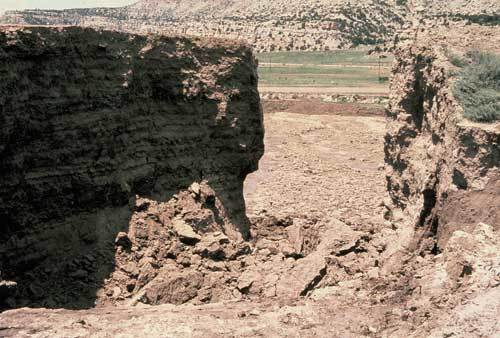
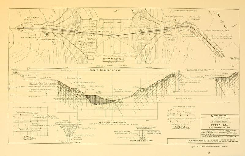
    <summary type="html"><![CDATA[<p><strong><em>Erupting one peaceful Saturday morning, the failure of this dam destroyed several towns, killed 11 people, drowned over 15,000 heads of livestock, and damaged over $2 billion of property in the area.  The fallout of this disaster led to the creation of many oversight groups and committees, dedicated to maintaining the integrity of dams all across the country to ensure that tragedies of this magnitude would never happen again.</em></strong></p><img src="https://www.intermountainhistories.org/files/fullsize/436df6764eb24d21f6563169ea341a43.jpg" alt="Teton Dam Schematics" /><br/><p>Finished in 1976, this dam is well known for its catastrophic failure and the subsequent flooding of Eastern Idaho.  Following years of alternating droughts and flooding, the Bureau of Reclamation proposed the created of a dam in 1963 to help regulate the water.  It was planned to be over 300 feet tall and would create a reservoir over 17 miles long.  Power turbines implanted in the dam would generate hydroelectric power to be sent to the nearby communities.  However, in 1971, conservationists and environmentalists began objecting to the dam, arguing that it would disrupt the habitat for trout and other local wildlife.  After a few years of complaints and a trial, construction on the dam began, which was finished in 1976, despite more legal complaints from conservationists and a brief labor strike.</p><p>On June 3, 1976, only a few months after completion, workers found two small leaks in the dam, followed by a smaller one found the next day.  By Saturday, June 5, a worker found more water leaking through the dam, and alerted the supervisors.  Soon, a second leak sprung, this one much higher than the last.  2 hours after the discovery, a wet spot appeared on the right side of the dam.  Bulldozers were called in to replace washed out material, but it was soon clear that the leak was much larger than they could repair.  Preparations soon began for the flooding and local Sheriffs were called to begin the evacuation.  By noon, the dam broke and water flooded the area downstream.  Cities in the area were soon hit with a massive wall of water.  A 15-foot-high wall of water destroyed the town of Wilford, and seriously impacted Sugar City and Rexburg.  Other nearby towns, like Teton and St. Anthony, were mostly unaffected due to higher elevation.</p><p>The nearby American Falls dam had been scheduled for much needed renovations and the flooding water threatened the integrity of this dam, as well as the safety of the people in the area.  The dam was quickly emptied in preparation for the coming of the water from the broken Teton Dam.  Water, spreading at over 10 miles an hour, from the broken Teton dam reached American Falls on the 7th of June, were the now empty American Falls dam was able to contain it and end the immediate emergency.  11 people died because of the dam and the flood caused over $2 billion of damages to local business and farm and livestock owners.  While legal experts found that the government was not liable for the damages caused, President Ford requested funds to help the people affected, and eventually the government paid over $300 million in claims to people who had lost property during the flood.</p><p>Due to the original failure, the dam was never fully reused.  It was the first of all the dams made by the Bureau of Reclamation to collapse, and left a bad mark on their record.  The dam was soon repaired and by January of the following year, repairs were completed.  Studies and expert testimony believed that one of the two big problems with this dam was poor placement.  Due to the porosity of local rock and the geological instability of the area, many geologists concluded that this was not a good site for a dam.  The second discovered problem was poor techniques used in the construction of the dam and poor oversight over some of the aspects of construction.  This led to the creation of the SEED, the Safety Evaluation of Existing Dams program, which inspected dams to ensure safety and other legislation to help prevent the reoccurrence of tragedies like this.  While the dam was repaired, it was never reused on the same scale that it was originally planned and some have made propositions for its reuse and for its destruction in the last few years.</p><p><em><strong><a href="https://www.intermountainhistories.org/items/show/93">For more (including 4 images) view the original article</a></strong></em></p>]]></summary>
    <published>2017-09-06T04:03:41+00:00</published>
    <updated>2026-04-17T19:31:59+00:00</updated>
    <link rel="alternate" type="text/html" href="https://www.intermountainhistories.org/items/show/93"/>
    <id>https://www.intermountainhistories.org/items/show/93</id>
    <author>
      <name>Josh Franzen, Brigham Young University</name>
    </author>
  </entry>
  <entry>
    <title type="html"><![CDATA[Thistle, Utah: Spanish Fork Canyon&#039;s Ghost Town ]]></title>
    <summary type="html"><![CDATA[<p><strong><em>Driving down US Highway 6, it’s still easy to point out the exact location of the massive landslide that led to the destruction of Thistle, a small railroad town in Spanish Fork Canyon. The landslide caused a natural dam that caused the Spanish Fork River to pool up, eventually flooding the town. While most of the town was destroyed in the flood, the skeletal structures of several buildings are still visible from US-6, a haunting reminder of nature’s awesome power. </em></strong></p><img src="https://www.intermountainhistories.org/files/fullsize/ea288ebbd8f7fa1ceb39f597f007fea2.jpg" alt="Thistle Station, Spanish Fork Canon. R.G.W.Ry. (Rio Grande Western Railway)" /><br/><p>Thistle got its start as a railroad resupply town. In fact, most of the early settlers were there on assignment from railroad companies to provide some rudimentary services to help out trains as they passed through town. Mormon settlers also made up a small part of the early population. </p><p>As rail traffic became more important in the West, Thistle’s role as a supply town grew: they provided a dining service for passing trains before the advent of dining cars, supplied helper engines for trains traveling up the mountains, and had extensive coal and water resupply facilities. The growth of the rail industry also resulted in the growth of the town. At its highest point in the late 1970s, Thistle had around 600 residents, and several other structures were built to accommodate its growing numbers, including bakeries, restaurants, saloons, and a two-floor schoolhouse. </p><p>In 1983, railway surveyors were the first to notice the changing geographical landscape. Their biggest worry was that the shifting earth would warp the rails, and they worked tirelessly with many different crews to try and keep the tracks in line. Their effort was to no avail, however, as the entire mountainside appeared to be slipping away. Rail officials eventually decided to abandon the line that ran through Thistle, and the State of Utah put out an evacuation notice to all Thistle residents to save what belongings they could and leave the town. The landslide ended up creating a natural dam that backed up the Spanish Fork River, and just a few days after the evacuation notice the flood destroyed basically the whole town. </p><p>While there weren’t any reported causalities from the landslide and flood, the economic consequences were large. Two trucking companies laid off workers, cancelled contracts, and even suspended operations. Most of the area's coal mines laid off miners, cancelled contracts, and experienced shut downs. Due to market conditions and the Thistle landslide, coal production dropped nearly 30 percent in 1983. Tourism in the area, particularly in-state tourism, was greatly reduced due to lack of access. To the south, the blockage of Highway 89 and the rail line hurt coal companies, turkey and feed operations, and gypsum, cement, and clay shipments. In total, the Thistle landslide caused total estimated capital losses of $48 million and revenue losses of $87 million.</p><p>Today, only the scattered remains of the town are visible. Half-submerged buildings, the old school house, and the occasional home are all that remains of this old railway town. It still serves as a stark symbol of nature’s power.   </p><p><em><strong><a href="https://www.intermountainhistories.org/items/show/34">For more (including 7 images) view the original article</a></strong></em></p>]]></summary>
    <published>2017-03-20T16:42:11+00:00</published>
    <updated>2026-04-17T19:31:58+00:00</updated>
    <link rel="alternate" type="text/html" href="https://www.intermountainhistories.org/items/show/34"/>
    <id>https://www.intermountainhistories.org/items/show/34</id>
    <author>
      <name>Addison Blair, Brigham Young University </name>
    </author>
  </entry>
</feed>