<?xml version="1.0" encoding="UTF-8"?>
<feed xmlns="http://www.w3.org/2005/Atom">
  <title type="text">Intermountain Histories</title>
  <updated>2026-08-18T15:59:49+00:00</updated>
  <generator uri="http://framework.zend.com" version="1.12.20">Zend_Feed_Writer</generator>
  <link rel="alternate" type="text/html" href="https://www.intermountainhistories.org/"/>
  <link rel="self" type="application/atom+xml" href="https://www.intermountainhistories.org/items/browse?output=rss2"/>
  <id>https://www.intermountainhistories.org/</id>
  <author>
    <name>Intermountain Histories</name>
    <uri>https://www.intermountainhistories.org</uri>
  </author>
  <link rel="hub" href="https://pubsubhubbub.appspot.com/"/>
  <entry>
    <title type="html"><![CDATA[Theodore Roosevelt and Roosevelt Dam: Story 6 of 8 of the President Theodore Roosevelt in the West Tour]]></title>
    <summary type="html"><![CDATA[<p><strong><em>President Theodore Roosevelt dedicated the Roosevelt Dam. At the time, it was the largest artificial lake and the largest masonry dam in the United States. </em></strong></p><img src="https://www.intermountainhistories.org/files/fullsize/a6393024b0add557182e524e08d64ac1.jpg" alt="Apache Indian men working on Roosevelt Dam" /><br/><p>The signing of the Newlands Reclamation Act by President Theodore Roosevelt in 1902 began “the construction of irrigation works for the reclamation of arid lands.” One of the first projects authorized under this act was the world’s largest masonry dam, the Roosevelt Dam. The first stone was placed on September 20, 1906. Benjamin Austin Fowler, a former lawyer from New York City, was central to the dam’s construction. Having left the city scene, Fowler moved to the West in 1899, where he purchased 400 acres in Glendale, Arizona, to become a farmer. With the dry climate and high temperatures, water was scarce, and his farming would be greatly aided if a reservoir could provide steady irrigation water access. Fowler lobbied for 17 years for a dam and reservoir to be constructed northeast of Phoenix, in a narrow canyon of the Salt River. The Roosevelt Dam was built to provide flood control, municipal and irrigation water, and hydropower for central Arizona. This project involved over 3,000 diverse workers. There was a shortage of workers in the summer because of the intense heat, and one of the engineers remarked, “White men won’t stay on this job because they cannot spend their money fast enough.” In turn, they hired Apache Indians who had already long dwelt in the area, and who had excellent labor skills. They completed the dam on February 5, 1911. Roosevelt Lake was the largest artificial lake in the world when it held over 1 million acres of water.
One month later, on March 18th, former President Theodore Roosevelt came with a wagon parade to dedicate the dam. As most of the previous roads were then under the waters of the new reservoir, they took a route up the Apache Trail. Roosevelt reflected on the beauty of the wildflowers and landscapes in his dedicatory speech. At 5:48 pm and with about 1,000 spectators, he flipped the electric switch and opened the gate to begin Arizona’s new era of water control. This contributed to many settlements and a growing community that would not have existed otherwise. Serving communities with sustainable water and energy, Fowler’s and Roosevelt’s efforts paid off as the Scientific American newspaper publicized on the dam’s dedication day, “With the completion of the irrigation system which is being constructed by the federal government, we may safely predict for this valley an era of progress and substantial growth which will place it in the forefront of the most up-to-date agricultural districts in the world.”
The Salt River Project has monitored Roosevelt Dam since 1911, and the site has changed in many ways. In 1992, overflowing problems necessitated renovations. The road to drive across it was removed, the dam was raised 23.5 meters, and a bridge was suspended over Roosevelt Lake. Today, many make the trek to enjoy the water and view the architectural feat that the Roosevelt Dam is.</p><p><em><strong><a href="https://www.intermountainhistories.org/items/show/923">For more (including 4 images) view the original article</a></strong></em></p>]]></summary>
    <published>2025-10-24T15:03:19+00:00</published>
    <updated>2026-08-18T15:52:26+00:00</updated>
    <link rel="alternate" type="text/html" href="https://www.intermountainhistories.org/items/show/923"/>
    <id>https://www.intermountainhistories.org/items/show/923</id>
    <author>
      <name>Jessika Cole, Brigham Young University</name>
    </author>
  </entry>
  <entry>
    <title type="html"><![CDATA[Keyhole Beach: The Key to Beach Life]]></title>
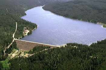
    <summary type="html"><![CDATA[<p><strong><em>The "key" to beach life in Wyoming can be found at Keyhole Beach. The land originally belonged to the Sioux, however, the U.S. government claimed it in 1877 and the beach was later created by the reservoir behind Keyhole Dam in 1952.</em></strong></p><img src="https://www.intermountainhistories.org/files/fullsize/a1198626791a7dda71da4448f593c7fd.jpg" alt="Keyhole Reservoir, 2008" /><br/><p>Located on the southeast shore of Keyhole Reservoir, Keyhole Beach is hailed for its fishing opportunities and as a “mecca” for bird-watching with about 225 species to see. Along with catching one of Wyoming’s largest fish, a freshwater drum, beachgoers can enjoy swimming, boating, kayaking, paddleboarding, sunbathing, and waterskiing. The closest campground is called Tatanka, after the Lakota word for “buffalo.” Tatanka Campground has the best selection of amenities in the area, including water and electric hookups for RVs and rentable cabins, as well as picnic tables at Tatanka, a marina, and a boat launch on the beach. </p><p>The Sioux inhabited and controlled the area long before the Bureau of Reclamation completed Keyhole Dam in 1952, and they continue to fight for this right today. In the Ft. Laramie Treaty of 1868, the U.S. recognized the tribe's ownership of the Black Hills territory which included the Šahíyela Wakpá River (also known as the Belle Fourche River). Named by French fur traders in the 1780s, Bella Fourche means “beautiful fork.” As miners illegally entered the territory throughout the 1870s, the settlers and the Sioux continued to have disputes about the ownership of the territory, and after the defeat of Custer at Little Bighorn, the U.S. waged war on the Sioux and then confiscated their land in 1877. While offered monetary compensation for the land grab after the 1980 Supreme Court case United States v. Sioux Nation of Indians, the Sioux believed this was an insufficient settlement and declined the money. The dispute over land ownership, and the Sioux’s claim on it, continues today. </p><p>As the gold rush persisted in the Black Hills more settlers moved in and in 1891 the Chicago and Northwestern Railroad entered the town of Belle Fourche, seventy-three miles to the northeast. The community became a livestock shipping hub and the name of Keyhole Reservoir derives from the livestock brand the McKean brothers used at their nearby ranch. The Bureau of Reclamation proposed the dam as a part of the Belle Fourche Project, started in 1904, which irrigated lands in the area. While ranchers protested the dam in 1950 due to their loss of farming land, the benefits of wildlife conservation, flood control, and recreational opportunities outweighed their concerns. </p><p>With the completion of the dam in 1952, beach life started to take off at Keyhole Reservoir with the creation of Keyhole State Park. In 1984, the Keyhole Expo was a county fair on the beach's shores that included hot air balloon racing, windsurfing, and more. In 1989, the State Park expanded upon the fair as a part of Wyoming State Park’s “Summerfest.” This event included boat rides to discover the beauty of Keyhole Reservoir, arts and crafts booths, and food concessions. </p><p>Today, Keyhole Beach hosts events such as a Lantern Fest where beachgoers can release floating lanterns on the reservoir and witness the illumination of the lake. Keyhole Marina also contains a bar and grill where visitors can eat and listen to live music on the beach. The community-oriented marina and campgrounds paired with scenic views make Keyhole Beach a memorable vacation spot.</p><p><em><strong><a href="https://www.intermountainhistories.org/items/show/845">For more (including 3 images) view the original article</a></strong></em></p>]]></summary>
    <published>2024-09-03T19:39:03+00:00</published>
    <updated>2026-04-17T19:32:19+00:00</updated>
    <link rel="alternate" type="text/html" href="https://www.intermountainhistories.org/items/show/845"/>
    <id>https://www.intermountainhistories.org/items/show/845</id>
    <author>
      <name>Olivia Hall, Northern Arizona University</name>
    </author>
  </entry>
  <entry>
    <title type="html"><![CDATA[The Crack at Glen Canyon, 1981 ]]></title>
    <summary type="html"><![CDATA[<p><strong><em><span style="font-weight:400;">In 1981, </span><span style="font-weight:400;">Earth First!</span><span style="font-weight:400;"> staged a demonstration at Glen Canyon Dam, giving the appearance of an attack. The incident placed the group on the national radar, with some calling this the birth of the radical environmental movement.</span></em></strong></p><img src="https://www.intermountainhistories.org/files/fullsize/483deaf10dd730edfd0ff19ddb60c859.jpg" alt="Glen Canyon, circa 1898" /><br/><p><span style="font-weight:400;">Earth First</span><span style="font-weight:400;">! members gathered on March 21, 1981 to protest the Glen Canyon Dam. Completed in 1966, the dam was the subject of much political controversy and protest by environmentalists. The dam flooded Pueblo cliff dwellings containing ancient artifacts; damaged the Colorado River ecosystem and endangered native species; and submerged the Cathedral in the Desert, a beautiful natural monument within the canyon. In the </span><i><span style="font-weight:400;">Earth First! Journal</span></i><span style="font-weight:400;">, the group described the dam as having “drowned the most magical place on the continent.” They claimed the dam as a symbol for humanity’s destruction of the planet, and invited members to join in protest. The demonstration was the focal point of a Spring Solstice and full moon celebration by the group.</span>
<span style="font-weight:400;">Seventy-five members of </span><span style="font-weight:400;">Earth First</span><span style="font-weight:400;">! lined up on the Colorado River bridge at Glen Canyon, carrying protest signs calling for the destruction of the dam and freeing of the river. Several members carried 300-feet of black plastic, then unfurled it over the dam to give the appearance of a large crack. These actions were inspired by </span><i><span style="font-weight:400;">The Monkey Wrench Gang</span></i><span style="font-weight:400;">, in which a group plans to blow up the Glen Canyon Dam. The author of the influential novel, Edward Abbey, attended the 1981 demonstration and gave a speech while standing on the back of a pickup truck. Abbey referred to Glen Canyon as a treasure stolen from the people by greedy developers and politicians, and the dam as an invasion. He urged the protestors to oppose the destruction of the Earth, and resort to sabotage and subversion when political action failed. </span>
<span style="font-weight:400;">As Abbey completed his speech, National Park Service police and Coconino County Sheriff’s deputies arrived. Law enforcement officers questioned protestors and attempted to disperse the crowd. According to </span><span style="font-weight:400;">Earth First</span><span style="font-weight:400;">! founder Dave Foreman, the FBI also investigated the incident and dusted the plastic “crack” for fingerprints. Media attention on the demonstration led to a sudden rise in </span><span style="font-weight:400;">Earth First</span><span style="font-weight:400;">! membership, with new members from across the country expressing interest in the movement. The “cracking” of Glen Canyon Dam is often cited as the first moment of radical direct action within the environmental movement. </span><span style="font-weight:400;">Earth First</span><span style="font-weight:400;">! was suddenly on the national radar as a radical alternative to mainstream environmental groups.</span>
<span style="font-weight:400;">Decades later, Glen Canyon remains a site of controversy. Environmental activists continue to argue for the decommissioning of the dam and restoration of the canyon. Despite growing interest in dam removal, the federal government views Glen Canyon and its reservoir, Lake Powell, as a necessity. Glen Canyon generates electricity for millions of homes, and Lake Powell is used for water storage for the Upper Basin states in the Colorado River Compact.</span></p><p><em><strong><a href="https://www.intermountainhistories.org/items/show/835">For more (including 4 images) view the original article</a></strong></em></p>]]></summary>
    <published>2024-05-27T15:31:48+00:00</published>
    <updated>2026-04-17T19:32:18+00:00</updated>
    <link rel="alternate" type="text/html" href="https://www.intermountainhistories.org/items/show/835"/>
    <id>https://www.intermountainhistories.org/items/show/835</id>
    <author>
      <name>Emily Roth, Northern Arizona University </name>
    </author>
  </entry>
  <entry>
    <title type="html"><![CDATA[A Beach in the Desert: Wahweap Beach]]></title>
    <summary type="html"><![CDATA[<p><strong><em>Originally discovered by the Indigenous tribes in the region and created by the growing reservoir behind Glen Canyon Dam, Wahweap Beach developed into a sought-after vacation spot through the construction of Wahweap Lodge by the Greene Family.</em></strong></p><img src="https://www.intermountainhistories.org/files/fullsize/aeab139905fd748f1dace82ace64c1bb.jpg" alt="Wahweap Beach, ca. 1961-1969" /><br/><p>In the middle of northern Arizona and southern Utah’s high desert sits the Wahweap Beach on the artificial oasis of Lake Powell. Wahweap Beach is the most popular recreational and lodging area on Lake Powell with a little over a million visits and about 425,000 overnight stays in 2021 alone. Along with swimming and sunbathing, beachgoers can kayak, paddleboard, jet ski, and powerboat. Wahweap includes amenities such as an RV-friendly campground, picnic tables, boat rentals, and the Lake Powell Resort, making for many options for how to spend time at the beach.</p><p>However, Wahweap Beach did not always exist. It began due to the rising waters of Lake Powell after the construction of Glen Canyon Dam from 1957 to 1964. Originally, “Wahweap” comes from the Paiute language, meaning “bitter water.” The name warned passing natives about the unsafe drinking water as Wahweap only saw running water during spring run-off and summer monsoons. Toward the end of the thirteenth century, the Ancestral Pueblo people fled the area of modern-day Lake Powell and later, the Navajo (Diné), Ute, and Paiute tribes moved into the area.</p><p>In the early days of Lake Powell, the Bureau of Reclamation owned the land, although it granted leases to Navajo farmers for cattle grazing. Bill Greene and his family purchased the lease that designated Wahweap Beach in 1957 from a Navajo man named Curly Tso. The family decided to invest and worked to acquire land concessions from the Arizona State Land Department. Despite strong competition, the family had the help of Barry Goldwater, Arizona senator, and Stewart Udall, House of Representatives member for Arizona’s 2nd District, and gained a concession to the land in 1959 from the National Park Service (NPS). This allowed the Greene family full control of the recreational use at the southern tip of the lake.</p><p>Construction then began on Wahweap Lodge and Marina, now called Lake Powell Resort, by the Greene’s family business, Canyon Tours, Inc. Bill Greene put in a temporary boat launch facility in 1963, and by 1965, Canyon Tours, Inc. finished building Wahweap Lodge which included forty-four guest rooms. These facilities began attracting tourists to its shores to swim, boat, and fish, thus creating the beach life at Wahweap.</p><p>The expected tourist turn-out was so great that in 1962, the NPS already had plans to develop a visitor center at Wahweap Beach. The Parks’ Services Interpretive Prospectus Glen Canyon National Recreational Draft proposed scientific, historical, and recreational-themed exhibits included at Wahweap. Ultimately, other locations such as the Bull Frog Visitor Center across the lake took on the role of interpretation, and included exhibits on human, geological, and natural history. Today, Wahweap is the most active beach and as of June 2023, its swimming spot, also referred to as “Swim Beach,” has been relocated by Glen Canyon National Recreation Area due to the reservoir’s declining water levels. Wahweap is now further from the boat ramps at the Marina, making for a more secluded beach on which to swim and lounge.</p><p><em><strong><a href="https://www.intermountainhistories.org/items/show/826">For more (including 4 images) view the original article</a></strong></em></p>]]></summary>
    <published>2024-05-22T23:55:14+00:00</published>
    <updated>2026-04-17T19:32:18+00:00</updated>
    <link rel="alternate" type="text/html" href="https://www.intermountainhistories.org/items/show/826"/>
    <id>https://www.intermountainhistories.org/items/show/826</id>
    <author>
      <name>Olivia Hall, Northern Arizona University</name>
    </author>
  </entry>
  <entry>
    <title type="html"><![CDATA[The Artesian Wells]]></title>
    <summary type="html"><![CDATA[<p><strong><em>Before Pineview reservoir was constructed, Artesian Park was integral in the pumping of water for Ogden resident. At its peak, Artesian Park had 48 wells pumping water to Ogden. These wells were a popular tourist attraction for those in northern Utah.</em></strong></p><img src="https://www.intermountainhistories.org/files/fullsize/61cf4e0d9bf605ca4022b3d58341af12.jpg" alt="Beneath Pineview Dam in 1920." /><br/><p><span style="font-weight:400;">Before Pineview reservoir was constructed, there was the Artesian Park. At its peak, the park had 48 wells pumping water to Ogden. The first well was dug in 1889 by Jame Ririe and had a depth of 84 feet, pumping 40 gallons of water per minute. As Ogden grew in population and importance, more wells were  needed. There were fifty-one wells dug from 1889 to 1935. Three of which were capped leaving 48 </span><span style="font-weight:400;">wells. The deepest well was 600 feet and the wells pumped a combined 811,000  gallons per minute or 16 million gallons a day providing water to over 40,000 Ogden residents.  </span>
<span style="font-weight:400;">The first “railroad car” that went up Ogden Canyon was developed in 1883 and driven by mules. In 1889, the mules  were replaced by steam engines and, in 1891, those were replaced by electric streetcars. The tracks were extended to Huntsville in 1913. In the winter of 1919, school boys cleared the track of ice and snow so they could ride the streetcar to school in Ogden. The boys did so because the company refused. It took a week to completely clear the tracks. In the winter of 1924, the tracks were buried under thick snow which stopped the streetcars. It took 100 men two days to uncover the tracks, which they did voluntarily. In 1924, for five cents, the Union Station announced they would be making trips every twenty minutes up the canyon to the Artesian Park because of its popularity.</span>
<span style="font-weight:400;">Mountain Park became a tourist attraction starting in 1915 when twenty-four wells were dug that year. By the 1920s, it was a must-see tourist attraction for northern Utah. There was even an ice cream shop right where the Pineview dam stands today. With its fifty acres and gushing water Utahns regularly made the trip up Ogden Canyon to have a picnic in the scenic area. </span>
<span style="font-weight:400;">When the area was first becoming an actual park, the </span><i><span style="font-weight:400;">Ogden Standard Examiner </span></i><span style="font-weight:400;">exclaimed: “No one thing accomplished by the city administration  promises more for Ogden than the development of the Artesian Wells and the making of plans to have Artesian Park one of the most beautiful outdoor spots in the Rocky Mountain region.”</span> <span style="font-weight:400;">The Artesian Park was important to the progression and development of Ogden, Utah. It gave northern Utahns a  leisure place and showed tourists the beauty of Utah. </span>
<span style="font-weight:400;">A study published in 1937 by the Department of the Interior showed that between September 1933 and October 1934, almost four billion gallons worth of water came from Artesian Park. </span><span style="font-weight:400;">In 1937, the Pineview Dam was filled and the artesisan wells were piped to Ogden for drinking water. By 1970, the Artesian Park was closed and six new, larger artesian wells were dug and the older 48 were capped. Yet, the same waters provide the majority of water for those in Ogden Valley today. </span></p><p><em><strong><a href="https://www.intermountainhistories.org/items/show/670">For more (including 4 images) view the original article</a></strong></em></p>]]></summary>
    <published>2022-10-17T19:51:14+00:00</published>
    <updated>2026-04-17T19:32:14+00:00</updated>
    <link rel="alternate" type="text/html" href="https://www.intermountainhistories.org/items/show/670"/>
    <id>https://www.intermountainhistories.org/items/show/670</id>
    <author>
      <name>Houston Crudele, Webster State University </name>
    </author>
  </entry>
  <entry>
    <title type="html"><![CDATA[Devil&#039;s Gate: Weber Hydroelectric Power Plant, Weber Canyon]]></title>
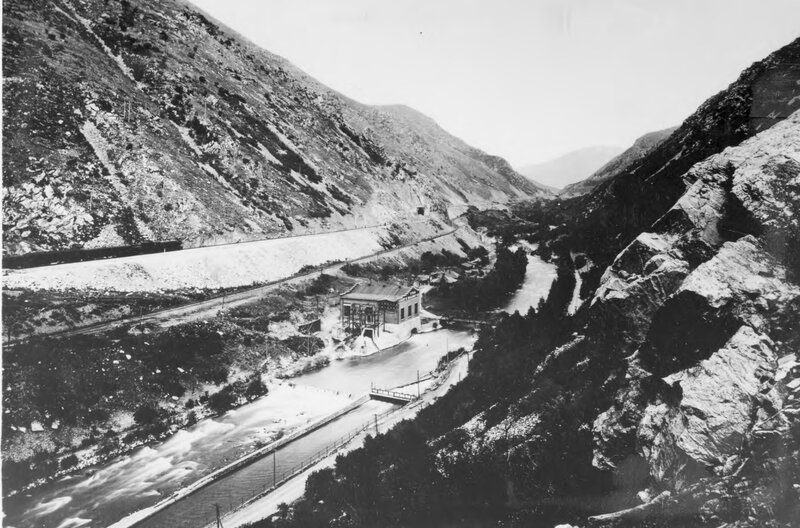
    <summary type="html"><![CDATA[<p><strong><em>The Weber Hydroelectric power plant has been in operation in 1910. Despite decreased usage, the plant continues to provide power to the local grid. </em></strong></p><img src="https://www.intermountainhistories.org/files/fullsize/ebb83febf330b3a1b119d21aecc11fe7.jpg" alt="Devil&#039;s Gate " /><br/><p><span style="font-weight:400;">Devil’s Gate-Weber Hydroelectric Power Plant is located in Weber Canyon. The power station was completed in 1910 on the Weber River. Crowded between steep, winding canyon walls alongside the Union Pacific Railroad and Interstate 84, the plant has stood for over 100 years.</p><span style="font-weight:400;">The conservation movement at the turn of the century was a scientific movement focused on rational planning to increase efficient use of all natural resources. Dams were a solution to making water usage more efficient. Dams conserve water for agriculture and municipal needs as well as provide flood control and electricity. This was the Progressive Era’s ideal approach to managing water resources. Ogden and Salt Lake City were rapidly industrializing at the end of the 1800s with the construction of railroads and and better public transportation. However, an efficient power grid was needed to maintain these advances. Thus, Devil’s Gate was a vital component to support a well-organized system for Ogden and Salt Lake City. </span>
<span style="font-weight:400;">During construction, a conflict with the Union Pacific Railroad almost prevented Devil’s Gate from being built. C. K. Bannister, an engineer involved in the construction of the Pioneer hydroelectric plant in Ogden Canyon, began work on Devil’s Gate in 1900. However, with the railroad next to the Weber River, Union Pacific Railroad officials were concerned a dam would damage the railbed and temporarily halted the dam's progress. Bannister died before work resumed, and his associates, Thomas D. Dee and David Eccles, sold the property rights to the Utah Light and Railway Company. Around the same time, the president of the Union Pacific Railroad, Edward Henry Harriman, purchased sixty-percent of Utah Light and Railway Company’s stocks, thus gaining majority control of the firm. Harriman intended to upgrade the Northern Wasatch Front’s electrical output to make it efficient for his electric streetcar operation in Salt Lake City. Unable to acquire more water rights in Ogden Canyon to improve the Pioneer plant, Harriman authorized the construction of Devil’s Gate with the stipulation that precautions be taken to protect the railroad embankment from potential erosion. Construction on the dam was completed two years later. </span>
<span style="font-weight:400;">With the rapid urbanization of the Wasatch Front at the end of the 1800s, several small power companies sprung up, creating intense competition. This led to corporate consolidations and larger power grids. Devil’s Gate was completed in 1910 and was one of the first power plants in Utah intended to feed an electrical grid. Previously, power plants adjusted their output based on the local daily or seasonal needs, but Devil’s Gate would run continuously at full capacity to meet the needs of the overall system powering all of Salt Lake City and Ogden, including Salt Lake City’s electric streetcars. In 1914, ownership of Devil’s Gate passed into the private hands of Utah Light and Traction, who lost all of its power stations to the Utah Power and Light Company in 1915. </span>
<span style="font-weight:400;">Under the ownership of the Utah Power and Light Company, several modifications were made to Devil’s Gate to increase its electrical capacity and efficiency. In 1989 it was placed on the National Register of Historic Places. It still functions within a power grid today, but its role is far smaller due to the construction of larger dams which surpass Devil’s Gate electrical output. </span></p><p><em><strong><a href="https://www.intermountainhistories.org/items/show/665">For more (including 4 images) view the original article</a></strong></em></p>]]></summary>
    <published>2022-10-12T18:55:36+00:00</published>
    <updated>2026-04-17T19:32:14+00:00</updated>
    <link rel="alternate" type="text/html" href="https://www.intermountainhistories.org/items/show/665"/>
    <id>https://www.intermountainhistories.org/items/show/665</id>
    <author>
      <name>Amber Bell, Weber State University</name>
    </author>
  </entry>
  <entry>
    <title type="html"><![CDATA[Hells Canyon Dam]]></title>
    <summary type="html"><![CDATA[<p><strong><em>Straddling the Idaho–Oregon border and holding firm to the walls of Hells Canyon, the Hells Canyon Dam provides hydroelectric power and irrigation channels to surrounding localities. A creation of the Idaho Power Company, the concrete dam is one of three in the Hells Canyon Complex, the largest privately-owned hydroelectric power complex in the nation, whose motivations and consequences can be felt politically and ecologically.</em></strong></p><img src="https://www.intermountainhistories.org/files/fullsize/010642938f4450485d7ddd6aff0409f0.jpg" alt="Damming Hells Canyon" /><br/><p>The Hells Canyon Complex was controversial before even being built, ever since the Idaho public scrutinized the Idaho Power Company’s request to license three dams on the Snake River in 1947. During the New Deal era, public power—a method of energy administration defined in which communities owned infrastructure under local government—was the norm for hydroelectricity; while Idaho Power wanted to privately run three dams, advocates for public power in the region instead contended against Idaho Power in favor of establishing a single, high dam. After a long battle, private power won when the Federal Power Commission issued Idaho Power a license in 1955, allowing them to build a private hydroelectric complex, in turn signaling a decline of public power’s favor nationwide. Due to the Hells Canyon dam construction in the deepest gorge on the North American continent, the construction process proved difficult, and builders had to dig a twenty-three-mile access road into the Idaho side of the canyon. Along with the road, contractors set up offices, facilities, housing, and a mess hall for construction workers. In a matter of six months, the Hells Canyon Dam’s construction was complete in 1967, and it began generating electricity shortly after.
The political controversy in the postwar years about whether hydropower was something to be publicly or privately owned has roots deep in the ecological. The Hells Canyon Complex sits on the Snake River Basin, a desert ecosystem, while many of the models that public ownership advocates used were based on dams built on the Columbia River Basin, which was forested and mountainous. Because of the ecological differences inherent to these basins, people interacted differently with these water systems, and as a result, their priorities varied in what services a dam should provide. In the Columbia Basin, priority was given to energy production, while in the Snake Basin, priority was given to irrigation. This is largely due to the relationship people had with the land. In the Snake Basin, people cultivated the land for crop harvest, so they wanted the Hells Canyon Complex to have irrigation as its chief operating principle. This gave wind to Idaho Power’s licensing for the three Snake River dams; a single high dam would better serve power generation, but Idaho Power contended that the three-dam complex better served irrigation.
While ecology shaped Hells Canyon Dam, the dam also reshaped the environment. By its very design, the Hells Canyon Complex has no passage for andronomous fish species, a type of fish that migrates from freshwater to the ocean in the Snake and Columbia Rivers. Limiting certain fish species’ ability to access any of the upper Snake River Basin between the complex to Shoshone Falls has dramatically reduced the species’ population and disturbed several ecosystems. This can be traced back to the general neglect of biological research before the construction of dams along the Columbia and Snake Rivers.</p><p><em><strong><a href="https://www.intermountainhistories.org/items/show/627">For more (including 3 images) view the original article</a></strong></em></p>]]></summary>
    <published>2022-06-30T19:53:46+00:00</published>
    <updated>2026-04-17T19:32:13+00:00</updated>
    <link rel="alternate" type="text/html" href="https://www.intermountainhistories.org/items/show/627"/>
    <id>https://www.intermountainhistories.org/items/show/627</id>
    <author>
      <name>Hunter Marang, College of Idaho</name>
    </author>
  </entry>
  <entry>
    <title type="html"><![CDATA[The Hoover Dam]]></title>
    <summary type="html"><![CDATA[<p><strong><em>At the time of its completion, the Hoover Dam was the largest dam in the world. Today, it remains the largest dam of its type in the United States and provides invaluable water to the southwest. </em></strong></p><img src="https://www.intermountainhistories.org/files/fullsize/8ab0bafd443bffdcd7e8b050c0f3664d.jpg" alt="Hoover Dam and Lake Mead" /><br/><p><span style="font-weight:400;">Nestled in the Black Canyon, the Hoover Dam helps control the Colorado River’s flooding cycle that once devastated nearby communities. Construction started in 1931 and finished in 1935. 21,000 individuals worked on the monumental project and just under 100 individuals died from the dangerous working conditions. In order to authorize building the dam, the states of Colorado, Wyoming, Utah, New Mexico, Arizona, California, and Nevada had to decide how to divide water rights along the Colorado River between themselves and Mexico. Ultimately, the Hoover Dam is not just an engineering marvel of American ingenuity but also a display of states working in union to overcome a shared problem. </span>
<span style="font-weight:400;">Before the Public Works Administration could begin construction, they needed labor. Would-be construction laborers flocked to Las Vegas for the chance to work on the construction of the dam. The project took place during the Great Depression and, although it was authorized under Herbert Hoover’s presidency, was a symbol of the public works projects that President Franklin Roosevelt used to put Americans back to work. The project was not without risks and conflict. In August of 1931, the workers at the Hoover Dam went on strike. Their complaint was against unsafe working conditions. Individuals toiled in tunnels that could reach up to 140 degrees, which was made worse by Las Vegas’s heat. In July, the average high of the day hovered at about 106 degrees. There were also casualties from the unsafe conditions, such as workers falling from heights of up to 800 feet. Construction also kicked up dust and produced carbon monoxide. Both are dangerous, with carbon monoxide being potentially deadly. Despite these dangers, sufficient labor remained. There were enough workers that Boulder City was created in order to provide closer living quarters to the worksite. </span>
<span style="font-weight:400;">The spectacle of the enormous structure has drawn tourists since before it was even finished. Tourists began visiting the dam before its completion, leading the team to construct an observation deck in order to keep visitors away from the dangerous worksite. Today, around 7 million individuals visit the dam itself while around 10 million individuals visit the lake created by the dam, named Lake Mead. At the time it was the largest dam in the world, and while others have eclipsed it in size, in the United States it remains the tallest dam, and Lake Mead the largest lake created by a dam.</span></p><p><em><strong><a href="https://www.intermountainhistories.org/items/show/476">For more (including 5 images) view the original article</a></strong></em></p>]]></summary>
    <published>2021-09-10T23:44:11+00:00</published>
    <updated>2026-04-17T19:32:10+00:00</updated>
    <link rel="alternate" type="text/html" href="https://www.intermountainhistories.org/items/show/476"/>
    <id>https://www.intermountainhistories.org/items/show/476</id>
    <author>
      <name>Nikki Smith, Brigham Young University</name>
    </author>
  </entry>
  <entry>
    <title type="html"><![CDATA[One of A Kind: Pine View Dam]]></title>
    <summary type="html"><![CDATA[<p><strong><em>Pine View Dam has a unique 3 layered system that is unmatched anywhere in America.</em></strong></p><img src="https://www.intermountainhistories.org/files/fullsize/fa746b6c0dcd177d6da85e452d8e80f0.jpg" alt="Front of Pineview Dam, looking east, 1987" /><br/><p>The Pine View Dam is a beautiful example of nature and human innovation. The Pine View Dam is made up of three unique layers that combine to comprise its overall integrity: artisan wells, original 61-foot structure of the 1930s, and the addition of 29 feet in the 1950s.</p><p>Settlers in the Ogden area first noticed artisan wells that spread out over the Ogden-Weber Basin. These first settlers were able to reap benefits from the beautiful water supply by using it for irrigation. The first layer of the dam made this possible and became integral to the Ogden community. Though the Ogden River provided the sustenance for life, it also held the ability to end life in the area. Due to yearly flooding, there were times that the early settlers faced the possibility of being washed from the benches of the Ogden River.</p><p>The second layer of the majestic Pine View Dam, finished in the 1930s, added 44,000 acre-feet of water. William R. Wallace, president of the Ogden River Water Users' Association, and Utah Governor Henry H. Blood, fought with the Bureau of Reclamation to secure funds to make this second layer possible and save the surrounding communities of the Ogden River. This second layer did not only add jobs and water to the area, but also provided irrigation for 1,250 farmers.</p><p>The addition of the third layer, needed because of population growth, was made possible by the Bureau of Reclamation who developed a cost-feasible solution. The adding of a third layer was made part of the Weber Basin Project. The 61-foot Pine View Dam would be raised to 90 feet, raising the total capacity to 110,200 acre-feet. The importance of these layers can be seen by the lush, green landscape of the Ogden-Weber Basin, as well as the bountiful products that are grown from the well-irrigated lands. Anyone who lives in this area can tell you the importance of the Pine View Dam, and all people can admire its beauty.</p><p><em><strong><a href="https://www.intermountainhistories.org/items/show/364">For more (including 3 images) view the original article</a></strong></em></p>]]></summary>
    <published>2019-10-10T22:43:41+00:00</published>
    <updated>2026-04-17T19:32:07+00:00</updated>
    <link rel="alternate" type="text/html" href="https://www.intermountainhistories.org/items/show/364"/>
    <id>https://www.intermountainhistories.org/items/show/364</id>
    <author>
      <name>Steven Uribe, Weber State University</name>
    </author>
  </entry>
  <entry>
    <title type="html"><![CDATA[Pioneer Hydroelectric Power Plant]]></title>
    <summary type="html"><![CDATA[<p><strong><em>Upon completion in 1897, the Pioneer Power Plant became a technological wonder, as it was the largest and most sophisticated power plant in Utah and perhaps the Western United States.</em></strong></p><img src="https://www.intermountainhistories.org/files/fullsize/b35141bd56f47a61dc470ef4528a7966.jpg" alt="Pioneer Electric Power Plant" /><br/><p><span style="font-weight:400;">Utah’s first hydroelectric plant was constructed by the Ogden City Electric Company in 1883. It supplied direct current to a few private customers in Ogden and nine city lights, but the next year high water partially destroyed the building. By 1887, it had been rebuilt in Ogden Canyon. This plant was replaced in 1890 by a steam plant at 23rd Street and Wall. </span>
<span style="font-weight:400;">In 1893, the Pioneer Electric Power Company was incorporated with leading Ogdenites at its helm: George Q. Cannon, Fred J. Kiesel, and Frank J. Cannon. Although its primary purpose was to generate power, the company was organized for a variety of purposes. The company provided irrigation water and eventually built a sugar factory in Ogden to process sugar beets. They contracted with Rhodes Brothers of Denver to construct a pipeline to carry water from Ogden River to the plant. Four work camps were established to house and feed the nearly 500 men who worked on the project; even a hospital was provided.  The pipeline was 31,600 feet long, required eight tunnels through solid rock, and included eight steel bridges. A contract was awarded to William Fisher in 1896 to build the power house and a transmission line was built leading to Salt Lake City and surrounding area.</p><p>The nation was in an economic recession during construction but a multimillionaire from Rhode Island, Joseph Bannigton, invested 1.5 million dollars to the cause.  Charles K. Bannister of New York was the lead architect and engineer on this project, as well as a partner of the Pioneer Electric Power Company. </p>
<span style="font-weight:400;">The overall size of the Pioneer Plant, along with its other design features, attracted a great deal of national attention. National engineering journals published numerous articles on the facility. In 1897, Henry Goldmark, an engineer for the Pioneer Electric Power Company, delivered a paper describing the plant at the annual convention of the American Society of Civil Engineers. A </span><span style="font-weight:400;">panel discussion followed Goldmark's presentation, during which one of the commentators, engineer Arthur L. Adams, stated that the Pioneer Plant "easily takes front rank among the high-pressure water-power developments and long-distance transmission plants in this country." </span>
<span style="font-weight:400;">Industrial growth failed to materialize. Surplus power became a nuisance to the company. In 1897, all companies serving the Salt Lake City and Ogden areas were consolidated into the Union Light & Power Company. These included the Ogden and Salt Lake Gas & Electric companies, the Citizens’ Electric Light Co., the Big Cottonwood Power Co. and the Little Cottonwood Water Power and Electric Co. In 1899, the company was reorganized into the Utah Light & Power Company and in 1904, it became the Utah Light & Railway Company. </span>
<span style="font-weight:400;">In 1906, W.H. Harriman purchased the company and spent millions rebuilding plants and transmission lines. The Utah Light & Railway Company built the Weber plant near the mouth of Weber Canyon.The architecture of the Pioneer powerhouse, reminiscent of the Italian Renaissance style, was a fitting symbol of the Pioneer Electric Power Company's prominence. Along with the powerhouse, the station included a brick shop and a large residence for the plant superintendent.</span>
<span style="font-weight:400;">After 1900, the Pioneer Plant underwent some important alterations. In 1913, new Francis-type reaction turbines were installed in the powerhouse. At the same time, an addition was built on the south side of the powerhouse to house switches and transformers which this equipment was later moved outside. In 1920, Utah Power and Light erected several new dwellings for the plant operators. By 1925, at least eight men worked at the powerhouse, which required constant monitoring.</span>
<span style="font-weight:400;">On a smaller scale, the Pioneer Power Plant is particularly significant to Ogden as it was the city's main source of electricity. On a larger sclae, the plant is significant to Utah as it provided a template for other power plants and helped service Salt Lake City with power. Upon completion the Pioneer Power Plant became a technological wonder,  as it was the largest and most sophisticated power plant in Utah and perhaps the Western United States. </span>
<span style="font-weight:400;">The Pioneer Power Plant is still a functioning part of Utah’s energy suppliers. Owned and operated by PacifiCorp, it is one of the most reliable forms of renewable energy for Utahns. The power plant is currently being fed water from the Pineview Reservoir, located 6 miles east of the plant itself. Water coming to the power plant is also diverted to help irrigate areas in Weber and Box Elder Counties. </span>
<span style="font-weight:400;">In 1989, the plant and its surrounding complex of buildings were nominated to the National Register of Historic Places as one of the first alternating current plants in the West. Some of the first high-voltage transmission experiments in the world were conducted at the plant.</span></p><p><em><strong><a href="https://www.intermountainhistories.org/items/show/355">For more (including 3 images) view the original article</a></strong></em></p>]]></summary>
    <published>2019-10-03T04:58:16+00:00</published>
    <updated>2026-04-17T19:32:06+00:00</updated>
    <link rel="alternate" type="text/html" href="https://www.intermountainhistories.org/items/show/355"/>
    <id>https://www.intermountainhistories.org/items/show/355</id>
    <author>
      <name>Ryan Evans, Weber State University</name>
    </author>
  </entry>
  <entry>
    <title type="html"><![CDATA[JFK at the Salt Lake City Municipal Airport: Story 5 of 5 of the John F. Kennedy’s Conservation Tour in September, 1963 Tour]]></title>
    <summary type="html"><![CDATA[<p><strong><em>The second public address given by President John F. Kennedy in Utah targeted the state’s development and its potential to become one of the most popular recreation areas in the U.S. At the end of his last speech during the Conservation Tour in the Intermountain West, JFK initiated the first power generator at the Flaming Gorge Powerplant along the Utah-Wyoming border.</em></strong></p><img src="https://www.intermountainhistories.org/files/fullsize/bade3215422a10e1786885a503087779.jpg" alt="President John F. Kennedy Starts the First Generator at Flaming Gorge Powerplant" /><br/><p>The last speech delivered by President Kennedy during his Conservation Tour in the Intermountain West was at Salt Lake City Municipal Airport.  In this address, which started at 9:35 a.m. on September 27, 1963, JFK explained how innovative resource conservation and development programs would benefit future generations. According to the President, wise management of resources would make a profound difference to the state of Utah, and preserving natural resources would make the state a great recreational attraction for tourists from all over the United States.</p><p>Kennedy dedicated the main part of the speech to the Flaming Gorge Dam on the Green River, one of the six dams that make up the Colorado River Storage Project. The President pointed out that the dam, with almost four million acre feet of capacity, would make Salt Lake City grow and properly organize the distribution of water along the Colorado River Basin. By pushing a buzzer, JFK started the first generator at the dam, making it run at full speed. Thus, the first unit of the Flaming Gorge Dam went into operation on September 27, 1963, at the flip of a switch by the 35th president of the United States.</p><p>Kennedy also emphasized the significance of the ceremony for the people of the state of Utah, stating that every drop of water should be organized to be of service to mankind. Using water wisely was not only crucial for the development of the state and the whole county in the 1960s, but also in the years to come. Kennedy was proud to implement the project that people had been thinking of for fifty years and highlighted the significance of the event for the state of Utah.</p><p>Before leaving, the president warmly greeted the people who had gathered to hear his speech. At 9:50 a.m. on September 27, 1963, Kennedy departed Salt Lake City Municipal Airport by jet for Seattle-Tacoma International Airport, thus ending his Conservation Tour in the Intermountain West. All of the speeches he delivered were well received, especially when he focused on foreign policy. The president’s visits made lasting impressions on everyday witnesses, thus increasing their understanding of the environment and its value.</p><p><em><strong><a href="https://www.intermountainhistories.org/items/show/225">For more (including 3 images) view the original article</a></strong></em></p>]]></summary>
    <published>2018-06-14T01:46:47+00:00</published>
    <updated>2026-08-18T15:59:49+00:00</updated>
    <link rel="alternate" type="text/html" href="https://www.intermountainhistories.org/items/show/225"/>
    <id>https://www.intermountainhistories.org/items/show/225</id>
    <author>
      <name>Anastasiia Shuvaeva, Northern Arizona University</name>
    </author>
  </entry>
  <entry>
    <title type="html"><![CDATA[Arrowrock Dam, Engineering Innovation and Building Block to Boise&#039;s Expansion]]></title>
    <summary type="html"><![CDATA[<p><strong><em>In 1911, the U.S. Reclamation Service broke ground on the Arrowrock Dam located on the Boise River, 22 miles upstream from Idaho’s capital.  Arrowrock Dam was the tallest dam in the world in 1915 when the project was completed. The dam is known as an engineering marvel that is referred as Idaho’s Eight Wonder of the World.</em></strong></p><img src="https://www.intermountainhistories.org/files/fullsize/9f5b9ad8b16c577bcefa5be76a5e0077.jpg" alt="Arrowrock Dam completion" /><br/><p>Arrowrock Dam transformed Boise by providing agricultural opportunities and is responsible for the development of Boise.  Boise's roots were in the goldfields of surrounding foothills during the mid-nineteenth century.  Around the 1860’s the gold rush declined, residents noticed the plentiful valley had an economic opportunity with agriculture, and irrigation became the key of the development.  Decades later after numerous ideas and attempts to provide irrigation to the Boise Valley, the newly formed U.S. Reclamation Service engineers came up with the idea of constructing a dam upstream on the Boise River. The dam’s purpose was to store water for crops from June to late September when water became scarce.  </p><p>The U.S. Reclamation Service could not begin constructing Arrowrock Dam until they built a railway to the construction site.  The railroad from Boise to Arrowrock Dam was the first government owned standard gauge common carrier line.  Construction on the railway began in August 22, 1910 and was completed in November 1911. On January 16, 1911, work began on the Arrowrock Camp found below the dam.  The camp functioned similar to a small town with an estimated thirty buildings.  The highest population of the camp was 1400 people, however the camp did not only have men, roughly 200 families also lived within the camp.  </p><p>Before construction on the dam could begin, the next step in the building process is a diversion tunnel through the side of a hill estimated 470 feet long.  After the diversion tunnel completed, the excavation began in February 1912 and the first cement pour was in November 1912.  </p><p>The Arrowrock Dam is considered the grandfather of many famous dams for example, the Hoover and Shasta Dam.  The Hoover and Shasta Dam’s built with the same system engineer Frank Crowe developed the Crowe Cable System.  The system used to pour concert and move material due to the height of the dam and move it a long distance a pour concert in a key point.  The dam revolutionized the way dams were constructed with similar techniques as well as similar design and models.  The construction of the Arrowrock Dam had a large process including a railroad to the construction site, camp building for workers and their families, and finally the dam construction.  The Arrowrock Dam has been called Idaho’s Eight Wonder of the World because of the unique the construction process, the size, and aesthetic appearance. </p><p><em><strong><a href="https://www.intermountainhistories.org/items/show/114">For more (including 4 images) view the original article</a></strong></em></p>]]></summary>
    <published>2018-01-31T19:47:05+00:00</published>
    <updated>2026-04-17T19:32:00+00:00</updated>
    <link rel="alternate" type="text/html" href="https://www.intermountainhistories.org/items/show/114"/>
    <id>https://www.intermountainhistories.org/items/show/114</id>
    <author>
      <name>Luke Hyde, University of Idaho</name>
    </author>
  </entry>
  <entry>
    <title type="html"><![CDATA[The Palisades Dam: Irrigation of the Snake River]]></title>
    <summary type="html"><![CDATA[<p><strong><em>This giant dam is an important structure in the economy of this area.  It prevents millions of dollars of flood damage every year and provides water for the farmers in the area.  It also fosters the recreation industry that is very strong in this area.  It is both an incredible landmark and a symbol for the success of the region. </em></strong></p><img src="https://www.intermountainhistories.org/files/fullsize/f8198694e23134cf593e29d52881c413.jpg" alt="Valley Before the Dam" /><br/><p>The largest dam in the area, the Palisades dam was build long after the other dams were completed.  After the success of the American Falls, Minidoka, and Jackson Dam, the Bureau of Reclamation realized that most of the dams supplied water to farmers in the lower area of the valley, while those in the upper valley struggled to find access to enough water, especially during drought years.  The Bureau began investigating new sites for one more dam in the area.  A number of surveyed sites were dismissed due to poor geology, and surveyors looked for a site that would create a sufficiently high reservoir while not being extremely high, to minimize the risk of failure.  Eventually, the Grand Valley site was selected, and renamed the Palisade site to avoid confusion with other projects in Colorado.</p><p>Construction began in 1946 and was finished by 1957.  The reservoir holds over a million acre feet of water, making it the second largest reservoir in the region, following the American Falls reservoir.  It provides water to about 650,000 acres of farm land, helping to grow grain, beans, potatoes, sugar beets, other vegetables, and many other seeds.  It serves as a home to many cutthroat trout, as well as other species of fish found in the area.  The power plant installed inside the dam generates a total of 176,600 kilowatt hours, enough to power a few hundred homes.  According to estimates by the Bureau of Reclamation, this dam helps produce almost $1 billion of services, accounting for the irrigation to crops, livestock fed, and recreation on the reservoir and the river.</p><p>One of the main purposes of the dam is flood control, helping to keep the amount of water steady throughout the year.  The Bureau estimates that this dam has prevented over $250 million of damages to farms and property, making it the largest contribution of a single dam to the prevention of flood damage.  One of its most well-known uses is for recreation.  The reservoir itself has over 70 miles of shore line and has become a popular fishing spot for local anglers.</p><p><em><strong><a href="https://www.intermountainhistories.org/items/show/92">For more (including 4 images) view the original article</a></strong></em></p>]]></summary>
    <published>2017-09-06T03:15:02+00:00</published>
    <updated>2026-04-17T19:31:59+00:00</updated>
    <link rel="alternate" type="text/html" href="https://www.intermountainhistories.org/items/show/92"/>
    <id>https://www.intermountainhistories.org/items/show/92</id>
    <author>
      <name>Josh Franzen, Brigham Young University</name>
    </author>
  </entry>
  <entry>
    <title type="html"><![CDATA[Minidoka Dam and Lake Walcott]]></title>
    <summary type="html"><![CDATA[<p><strong><em>Helping to turn a desert into farmland, this dam is an important element of the modern ecosystem of the area. It provides a home for much of the local wildlife, as well as life-giving water for farmers who rely on the water stored here to irrigate their fields. It was an important pioneer in hydroelectricity and spurred the creation of thousands of miles of irrigation canals throughout the state.</em></strong></p><img src="https://www.intermountainhistories.org/files/fullsize/2c84fcebd589e8eb43e9768273660053.jpg" alt="Minidoka Dam" /><br/><p>Located between the city of Minidoka and Highway 86, this dam and its corresponding lake provide water for most of the surrounding area. It serves as an oasis for nearby fauna and provides fishing and boating for local residents. The small island inside the reservoir is called Bird Island, as it is a popular roost for many different species of local birds. According to the Fish and Wildlife Center, there have been over 235 different species of birds observed in this area. Fishermen can find various species of trout and catfish, as well as steelhead, white sturgeon, and both small and large mouth bass.</p><p>The construction of this mile-long dam began in 1904 as the first major reclamation project in Idaho. The dam ended up being about 86 feet high and was originally made with compacted earth.  Later, parts would be reinforced with concrete as various sections of the dam began to erode away. The lake that was created by stopping the Snake River was named Lake Walcott, after a member of the construction crew. The lake has a 210,200 acre-feet storage capacity, and is about 8 miles long and about a mile wide, at the larger points. This dam cost $5.8 million to construct, which would be about $156 million today.</p><p>Originally, the dam was only intended to provide water for irrigation and agriculture. However, engineers soon realized the potential for hydroelectric power provided by the dam. In 1909, they began construction on the power plant that now provides electricity for many of the surrounding cities. The city of Rupert was one of the first cities in the US to be completely powered by electricity, drawing its power from the dam’s storage. Similarly, the addition of the power plants allowed for the diversion of water uphill, using electricity, which provided water to land at a higher elevation than the dam. Additional units were added to the power plant in 1927 and 1942 as the nearby cities grew and the demand for water and electricity increased. In 2011, workers began to replace many of the outdated aspects of the dam and installed new and more efficient technology, making the dam more effective and much safer.  </p><p>This dam led to the irrigating of many of the nearby farms, which quickly brought farmers and entrepreneurs to the area. Within a decade, a formerly-barren wasteland, filled with tumbleweeds and desert, was filled with 17,000 people, thousands of green farms, and several new, small cities. The creation of this dam spurred enormous population growth and led to the creation of other dam and irrigation projects in the area.</p><p><em><strong><a href="https://www.intermountainhistories.org/items/show/90">For more (including 4 images) view the original article</a></strong></em></p>]]></summary>
    <published>2017-09-03T03:38:02+00:00</published>
    <updated>2026-04-17T19:31:59+00:00</updated>
    <link rel="alternate" type="text/html" href="https://www.intermountainhistories.org/items/show/90"/>
    <id>https://www.intermountainhistories.org/items/show/90</id>
    <author>
      <name>Josh Franzen, Brigham Young University</name>
    </author>
  </entry>
  <entry>
    <title type="html"><![CDATA[The Island Park Dam and Compromise of Conservation]]></title>
    <summary type="html"><![CDATA[<p><strong><em>After two decades of fighting between local farmers and national conservationists, this dam served as a compromise between the desire to settle Idaho and the need to preserve the natural beauty of Yellowstone.   Its unique location also experiences some of the most drastic temperature changes in the state of Idaho.</em></strong></p><img src="https://www.intermountainhistories.org/files/fullsize/e711672041baa5ebaf63dd6b7f1c3608.jpg" alt="Island Park Preparation" /><br/><p>Located on the western edge of Yellowstone, this dam had a very controversial beginning.  A few dams in this area had been planned in the late 1910's, after the success of the Minidoka Dam.  However, these plans were put on hold as conservationists in the area successfully lobbied Congress into stalling these projects.  They argued that by virtue of being on federal land, the area should be protected and preserved by the Federal Government.  This came as a backlash against the flooding of the Hetch Hetchy Valley in Yosemite National Park through the creation of the O'Shaughnessy Dam.</p><p>Similar requests by farmers in California led to the creation of the O'Shaughnessy Dam in 1919 and was soon denounced by conservationists.  Special legislation had been passed to allow the creation of a dam in a federal park, which required that the dam is held in public hands.  The dam was soon sold to a private company, which further angered the conservationists, who saw this as an attack on the entire idea of the federal park system.  They were successful as they lobbied congressmen to stall the authorization of the proposed.  Even President Franklin D. Roosevelt opposed the creation of a dam on the Yellowstone Lake, the site of the most controversial dam proposal.  However, by 1937, it was apparent that local farmers were running out of irrigable waters and a compromise between the two factions was reached.  Two dams would be created near the confines of Yellowstone: the Island Park Dam and the Grassy Lake Dam.  However, they were to be much smaller than the proposals had called for and would be planned to minimize their effect on the national park.  Farmers would be able to access the water stored in the dam, especially during particularly dry seasons.</p><p>Construction of this dam began in 1937 and was completed in 1939.  Much like the Grassy Lake Dam, this is an earth fill dam.  Its corresponding reservoir holds 135,000-acre feet of water, making it smaller than the Jackson Lake and American Falls, though larger than Lake Walcott and Grassy Lake.  It is located in the Caribou-Targhee National Forest and supplies most of the nearby towns in Idaho with irrigation water.  This dam also boasts the eighth coldest temperature ever recorded in the United States.  On January 18, 1943, this dam reached -60 degrees Fahrenheit, the coldest temperature recorded in Idaho.</p><p><em><strong><a href="https://www.intermountainhistories.org/items/show/79">For more (including 4 images) view the original article</a></strong></em></p>]]></summary>
    <published>2017-08-12T01:12:04+00:00</published>
    <updated>2026-04-17T19:31:59+00:00</updated>
    <link rel="alternate" type="text/html" href="https://www.intermountainhistories.org/items/show/79"/>
    <id>https://www.intermountainhistories.org/items/show/79</id>
    <author>
      <name>Josh Franzen, Brigham Young University</name>
    </author>
  </entry>
  <entry>
    <title type="html"><![CDATA[The Grassy Lake Dam and Casualty of Compromise]]></title>
    <summary type="html"><![CDATA[<p><strong><em>The debate between conservation and reclamation postponed the creation of this dam.  The original dam site was going to be off the Yellowstone Lake, but was split into two separate dams.  One, the Grassy Lakes Dam, is the smallest reservoir created by the Minidoka Project.  While is it very close to the Jackson Lake, it is uphill from the other lake and provides water to farmers whose fields are uphill from the other lakes in the area.</em></strong></p><img src="https://www.intermountainhistories.org/files/fullsize/53a68faaadbe553af6085669b614d733.jpg" alt="Grassy Lake Dam" /><br/><p>While this dam is fairly small compared to the nearby Jackson Lake, the creation of this dam was quite dramatic.  In 1919, after working on the Jackson Lake dam, proposals were made for another dam in the Bechler Meadows.  This was an attempt to use the local water for irrigation and farming.  No real action was undertaken for some time, but within a few years, conservationists became alarmed that this dam (along with a few other dam proposals in the area) would recreate the infamous Hetch Hetchy project in Yosemite National Park.  </p><p>In 1919, construction began on the O'Shaughnessy Dam, which created the Hetch Hetchy Reservoir.  This dam was constructed inside a National Park and required special legislation for approval.  The legislation decided that public lands should be used for public benefit and that the scenic valley would be of more use to the community of California as a dam than a place for sightseeing.  By the time of the dam's completion, many groups had already begun calling for the removal and prevention of dams in the name of conservation, the idea that the natural landscape should be preserved.  The Grassy Lake dam fell victim to the backlash against the flooding of the Hetch Hetchy Valley and was postponed.</p><p>After two decades of political debates, a compromise between local irrigators and conservationists in Congress allowed for the creation of two dams, both added to the Minidoka Project.  The Grassy Lake dam was to be created at the head of Cascade Creek, near the Fall river and close to the southern edge of Yellowstone.  This would prevent Yellowstone Lake from being diverted for irrigation, preserving it for future generations.  It would still allow farmers in the area to have access to water during especially dry seasons.  In 1937, construction began and by 1939, the dam was completed.  It is an earth fill dam and can hold 15,000 acre-feet of water.  It is a little over a mile in length and less than half a mile wide.  Recently, in both 1996 and 2004, the Reclamation Bureau modified and replaced some worn out sections of the dam. </p><p><em><strong><a href="https://www.intermountainhistories.org/items/show/78">For more (including 3 images) view the original article</a></strong></em></p>]]></summary>
    <published>2017-08-11T12:06:42+00:00</published>
    <updated>2026-04-17T19:31:59+00:00</updated>
    <link rel="alternate" type="text/html" href="https://www.intermountainhistories.org/items/show/78"/>
    <id>https://www.intermountainhistories.org/items/show/78</id>
    <author>
      <name>Josh Franzen, Brigham Young University</name>
    </author>
  </entry>
  <entry>
    <title type="html"><![CDATA[The American Falls Dam and Moving a Town]]></title>
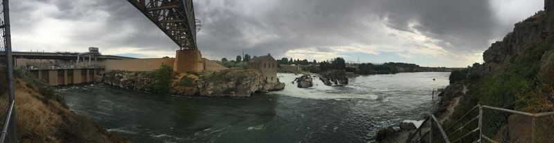
    <summary type="html"><![CDATA[<p><strong><em>Underneath this massive reservoir lies the remains of the original town of American Falls.  Located in the best spot for a dam, the entire town had to be moved by cart uphill.  The cement grain silo deemed too difficult to move can still be seen poking out of the dam, and during an extremely low tide, you can walk on the old sidewalks where the city used to be.</em></strong></p><img src="https://www.intermountainhistories.org/files/fullsize/66c6dffe0a8292ec8c6e28060087c6d2.jpg" alt="The American Falls Dam Today" /><br/><p>The idea for the American Falls dam began after the success of the nearby Minidoka Dam led to better farmland and increased population.  In 1908, limited testing of a dam site began, and a decade later, in 1918, geological investigations began that led to the proposal of a dam in 1919.  This proposal presented a controversial issue, as it claimed that the best place for a dam and subsequent reservoir would be right where the town was located.  The authors of the proposal called for the relocation of a large section of American falls, a massive undertaking for a city that was starving from the falling crop prices of the post WW1 era.  Deliberations on both the federal and local level took years to conclude that the dam was necessary and to finally begin the process of moving.</p><p>The Bureau of Reclamation purchased many of the properties that would soon be flooded by the dam, and helped to clear the sagebrush to make new properties for these relocated homeowners.  They would eventually buy 329 properties in the area, while some homeowners decided to keep their claim on the land soon to be flooded.  However, by the end of 1921, the head of the Reclamation Service decided that this project was too costly and ordered it ended.  This alarmed many local farmers, who depended on dams and irrigation for water.  A group of local businesspeople and farmers raised enough money to cover the additional costs and petitioned  the Bureau to resume construction on the dam.  With half of the financial cost covered by the local community, the head of the Bureau of Reclamation acquiesced and resumed planning to move the city.</p><p>In 1925, construction began.  Old power lines and railroads had to be relocated around the dam, and the monumental task of moving the entire city had to be undertaken.  Most of the buildings in the city were moved by horses pulling large wheeled carts.  Famously, one particular Sunday, the St. John Lutheran Church was in transit and several worshipers attended their service in the church while it was on wheels.  By the end of 1925, all the buildings and markings from the former town site had been moved, with some exceptions.  All that remained were a few foundations, some sidewalks, and the giant concrete grain silo that was deemed too difficult to move.  The dam was finished in 1926, and local banks began opening up and expanding services, hopeful for the economic boost that this dam would bring.</p><p>The dam held more than 1.7 acre-feet of water and stretched for miles along the Snake river.  However, by 1973, it became evident that weathering and wear on the dam necessitated complete replacement of the structure.  The new dam, finished in 1978, was built downstream of the old dam, and actually lowered the amount of water that could be held.  Today, it supplies thousands of farms with water.  The cement grain silo can still be seen from the dam, as well as the old powerhouse.  This building was built two decades before the dam was made, utilizing the natural waterfall to generate power, which was sent via power lines to Pocatello.  The generator that was originally installed is still located within the dilapidated building, though it is impossible to reach.</p><p><em><strong><a href="https://www.intermountainhistories.org/items/show/77">For more (including 4 images) view the original article</a></strong></em></p>]]></summary>
    <published>2017-08-11T11:01:50+00:00</published>
    <updated>2026-04-17T19:31:59+00:00</updated>
    <link rel="alternate" type="text/html" href="https://www.intermountainhistories.org/items/show/77"/>
    <id>https://www.intermountainhistories.org/items/show/77</id>
    <author>
      <name>Josh Franzen, Brigham Young University</name>
    </author>
  </entry>
  <entry>
    <title type="html"><![CDATA[The Glen Canyon Dam, Environmentalists, and Recreation]]></title>
    <summary type="html"><![CDATA[<p><strong><em>Since the decision to dam Glen Canyon in 1956, it has become a symbol of loss and sacrifice on the Colorado River to preservationists.</em></strong></p><img src="https://www.intermountainhistories.org/files/fullsize/274cbd373fe29102b3ac5c579702dae7.jpg" alt="Glen Canyon Dam from the Air" /><br/><p>Successful in his fight against Echo Park Dam David Brower came to regret his strategy of supporting a dam at Glen Canyon. In the late 1950s, the Sierra Club took trips to the canyon. In was only then that its members understood the natural beauty and scenery it had to offer. Brower’s friends feared for him as he grew depressed over the loss. Those that knew the canyon, such as pioneer river guide Norman Nevills and ferry operator Art Chaffin, loved the canyon but their voices were few in the crowded political debate. As if to rub salt into David Brower’s wounds, Luna Leopold of the U.S. Geological Survey waited until after construction of the dam had started to write a report which stated that Hoover Dam sufficiently stored water for the Colorado River and that therefore Glen Canyon Dam was unnecessary. Preservationists now consider Glen Canyon a symbol of loss. </p><p>Brower recovered from his initial depression and continued to fight for the preservation of the Colorado Plateau. He helped produce the publication of The Place No One Knew: Glen Canyon on the Colorado River, which brought the canyon to the public in vivid color. It was a piece of nostalgia looking back at Glen Canyon, rather than an attack on dam building. Dams flooded other canyons such as Flaming Gorge, Horseshoe and Kingfisher yet they did not receive the level of attention that Glen Canyon did. During the 1950s environmentalists did not have the political strength to oppose all dam building. Glen Canyon Dam was elevated to notable significance because of the scale of damage it did. </p><p>Lake Powell came into existence in 1966 as construction workers closed the tunnels that had previously rerouted the Colorado River around the unfinished dam. Beautiful in its own way, Lake Powell is a popular tourist destination. It now sits within the 1.25 million-acre Glen Canyon National Recreation Area. Elaborate houseboats accommodate the two million annual visitors who come to relax, drink, and have fun. For the local tourism industry, the lake has been a huge economic boost. The National Park Service reported that in 2011, 2.3 million visitors spent $238 million in nearby communities. This spending supported 2819 jobs. Lake Powell is now a vital part of the local community. </p><p>Many things were lost to the waters of Lake Powell. These include prehistoric ruins, unique geological features that went unstudied, and native fish populations that were unable to cope with the change of habitat, as well as distinctive beauty unknown to the modern day. The rising waters of Lake Powell created a time limit for archaeologists who had to rush to retrieve as much information as possible. To help, inexperienced workers joined the digging but large areas were not reached before they were flooded.  It is unlikely that Lake Powell will ever be drained. Despite this, a lot can be learned from how the attitude of the environmentalist movement facilitated the damming of Glen Canyon to save Dinosaur National Monument. </p><p><em><strong><a href="https://www.intermountainhistories.org/items/show/58">For more (including 6 images) view the original article</a></strong></em></p>]]></summary>
    <published>2017-06-05T17:59:09+00:00</published>
    <updated>2026-04-17T19:31:59+00:00</updated>
    <link rel="alternate" type="text/html" href="https://www.intermountainhistories.org/items/show/58"/>
    <id>https://www.intermountainhistories.org/items/show/58</id>
    <author>
      <name>George Mumford, Northern Arizona University</name>
    </author>
  </entry>
  <entry>
    <title type="html"><![CDATA[Echo Park Dam and the Early Environmental Movement]]></title>
    <summary type="html"><![CDATA[<p><strong><em>In the 1950s the Environmentalism Movement was only just beginning. For the early movement the battle over Echo Park was significant. </em></strong></p><img src="https://www.intermountainhistories.org/files/fullsize/f436051c94ca67ab4a6e1b81e422a860.jpg" alt="U.S. Geological Survey, 1871" /><br/><p>The Colorado River Storage Project (CRSP) planned for comprehensive development of the Colorado River. By damming the river the Bureau of Reclamation hoped the water could be managed efficiently. At the center of this project would be a dam at Echo Park within Dinosaur National Monument. Echo Park Dam, announced in 1953 by Interior Secretary Douglas McKay, was meant to fulfill multiple purposes. Under the Colorado River Compact of 1922, the Upper Basin states had to provide 7.5 million acre-feet of water to the Lower Basin. Echo Park Dam would be a water storage facility to ensure this obligation could be met. Additionally, the dam would provide water for irrigation and a cheap source of hydroelectricity. This power would, in turn, be used in part to fund other development projects. </p><p>In the 1950s, most Americans understood conservation to mean the efficient use of resources. The Bureau of Reclamation pushed heavily for the development of the Colorado River to fuel the growth of the southwest. CRSP would ensure that the Upper Basin states got all of their allotted water, under the 1922 compact, before it flowed away to California. Even environmentalists at this time saw the build-up of the Colorado Plateau as inevitable: some even welcomed it. However, they were also concerned about preserving areas of particular significance, which is what made the dam a contentious issue. </p><p>Environmentalists believed that it set a dangerous precedent to let Dinosaur National Monument be flooded. In fighting against the dam, environmental leaders, including David Brower of the Sierra Club, argued that a dam at Glen Canyon would satisfy the demand for a dam while saving a national monument. Many were inspired by the columnist Bernard DeVoto who wrote in the Saturday Evening Post that the dam must be stopped to save Dinosaur and its unique natural beauty. DeVoto warned that the Echo Park Dam would set an example that put every national park and monument at risk. This desire to preserve national monuments, not stop dams, motivated many environmentalists. </p><p>In a defining moment, Brower corrected evaporation statistics put forward by the Department of Reclamation in front of a congressional subcommittee. Not only did Brower discredit the department but he also proved that Glen Canyon would make for a suitable replacement, as water loss through evaporation there would not be much greater. Environmentalists employed a successful campaign that became the basis of the movement. New techniques such as the publishing of books known as coffee-table propaganda, added to their arsenal. At the last moment, David Brower tried to convince the Sierra Club to oppose CRSP but failed. The fate of Glen Canyon and Echo Park was sealed. In 1956 Congress passed an amended Colorado River Storage Project Act which now stated that no dam should be built in a national park or monument. The environmental movement had however won a major victory and now had validation of its objectives to preserve the land.</p><p><em><strong><a href="https://www.intermountainhistories.org/items/show/56">For more (including 4 images) view the original article</a></strong></em></p>]]></summary>
    <published>2017-06-03T16:22:52+00:00</published>
    <updated>2026-04-17T19:31:58+00:00</updated>
    <link rel="alternate" type="text/html" href="https://www.intermountainhistories.org/items/show/56"/>
    <id>https://www.intermountainhistories.org/items/show/56</id>
    <author>
      <name>George Mumford, Northern Arizona University</name>
    </author>
  </entry>
</feed>