<?xml version="1.0" encoding="UTF-8"?>
<feed xmlns="http://www.w3.org/2005/Atom">
  <title type="text">Intermountain Histories</title>
  <updated>2026-04-17T19:32:05+00:00</updated>
  <generator uri="http://framework.zend.com" version="1.12.20">Zend_Feed_Writer</generator>
  <link rel="alternate" type="text/html" href="https://www.intermountainhistories.org/"/>
  <link rel="self" type="application/atom+xml" href="https://www.intermountainhistories.org/items/browse?output=rss2"/>
  <id>https://www.intermountainhistories.org/</id>
  <author>
    <name>Intermountain Histories</name>
    <uri>https://www.intermountainhistories.org</uri>
  </author>
  <link rel="hub" href="https://pubsubhubbub.appspot.com/"/>
  <entry>
    <title type="html"><![CDATA[The Rush Creek Point Fire Lookout and Fire Suppression <br />
]]></title>
    <summary type="html"><![CDATA[<p><strong><em>Rush Creek Point Fire Lookout is an abandoned fire lookout overlooking the Rush, Cabin, and Big Creek drainages in central Idaho’s Payette National Forest, built by the Civilian Conservation Corps (CCC) as part of the Forest Service’s fire suppression efforts.</p></strong></p><img src="https://www.intermountainhistories.org/files/fullsize/2f634c9d453524fbbca9cd296dfe52ac.jpg" alt="Rush Creek Point Fire Lookout " /><br/><p>The Rush Creek Point Fire Lookout is a small structure built in 1937 by the Civilian Conservation Corps to monitor fires from its vantage point straddled between the Big Creek and Rush Creek drainages. Fire lookouts were necessary due to the Forest Service’s 10:00 AM policy, which announced that forest fires should be put out by 10:00 AM on the day after they occurred. To make this feasible, the CCC built fire lookouts while the Forest Service strung telephone lines throughout the national forests for communication with the outside world. The surplus of labor during the Great Depression made this development possible with the government-sponsored work-relief programs of the New Deal, such as the CCC. </p><p>The aggressive fire-fighting policy of the Forest Service often proved impracticable in Idaho. Forest Service employee Elers Koch noted in his 1935 article “The Passing of the Lolo Trail,”  the failures of the firefighters to contain the conflagrations even under ideal conditions, suggesting that perhaps some of this difficulty originated from the buildup of fuels as a result of earlier fire suppression. Despite these early concerns, the Forest Service maintained the 10:00 AM policy until 1977, after which fires were addressed with individualized plans often including alternatives to suppression.</p><p>The 1980 Central Idaho Wilderness Act further reduced the necessity of the Rush Creek Point Fire Lookout by defining this portion of the Payette National Forest as part of the Frank Church-River of No Return Wilderness Area. This limited the fire suppression activities that the Forest Service was legally allowed to conduct, since in wilderness areas the use of motorized tools is prohibited. Furthermore, suppressing fire at all in wilderness is only questionably legal, since the act calls for wilderness “untrammeled” by man. Abandoned, the Rush Creek Point Fire Lookout has been out of service for many years, a relic of the Forest Service’s aggressive fire suppression. </p><p><em><strong><a href="https://www.intermountainhistories.org/items/show/302">For more (including 2 images) view the original article</a></strong></em></p>]]></summary>
    <published>2019-02-14T00:25:36+00:00</published>
    <updated>2026-04-17T19:32:05+00:00</updated>
    <link rel="alternate" type="text/html" href="https://www.intermountainhistories.org/items/show/302"/>
    <id>https://www.intermountainhistories.org/items/show/302</id>
    <author>
      <name>Everett Masterman, University of Idaho</name>
    </author>
  </entry>
  <entry>
    <title type="html"><![CDATA[Senator Heyburn and the Northwest&#039;s First State Park]]></title>
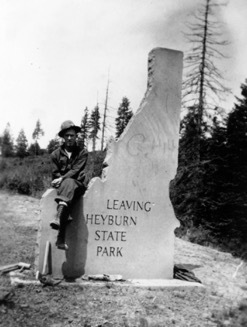
    <summary type="html"><![CDATA[<p><strong><em>In 1908 Heyburn State Park became the Idaho's first state park and the first in the entire Pacific Northwest. Senator Weldon Heyburn pushed to create a national park in Idaho, but had to settle on a state park. Heyburn State Park developed and grew with the region, creating a local and regional recreation spot for people to enjoy. </em></strong></p><img src="https://www.intermountainhistories.org/files/fullsize/46e5b97f8a2153ec2101d9da7440942b.jpg" alt="Heyburn State Park Sign" /><br/><p>When Senator Weldon Heyburn begain dreaming of a new national park in Idaho, the General Allotment Act of 1877 had recently opened up a large swatch of land. After this Act, members of the Coeur d’ Alene Indian Tribe people each received 160 acres of land, and the rest would be divided among homesteaders. Since the land was Indian land, Congress got involved. In 1907 Heyburn introduced two bills aimed at creating a national park in Idaho. But both stalled in the House Committee on Indian Affairs. A second bill passed after a word change without Heyburn’s knowledge. The wording changed the park from a national park to a state park, allowing Idaho to buy land. Heyburn strongly opposed the idea of a state park, stating, “I do not believe in creating a park that shall be the property of the state…They are always a subject of political embarrassment.” Despite his opposition, President Theodore Roosevelt signed the bill into law on April 30, 1908. </p><p>After the formation, Heyburn State Park grew to meet the needs of the many visitors. The area was already a local vacation spot with many people renting houseboats for the summer. Local newspapers saw the park creating new opportunities. State Game Warden, Ben Gray, had high hopes for the park, stating, “There is no doubt in my mind but that Heyburn park will become a mecca for pleasure seekers in this state and its reputation will spread throughout the entire northwest.” He shared this vision with Governor James Hawley and George Pickett, who made up the Heyburn State Park commission. They envisioned a place where people could moor their houseboats, fish and hunt, and recreate during the year. A writer for the Idaho Statesman described how great the fishing was in the park, and declared, “The black bass and perch at Heyburn park not only grow to a large size, but are finely flavored, and fishing is therefore one of the main attractions there.” Other newspapers as well reported on the array of recreational opportunities. Plans were underway to create a hotel in the park to draw in more tourists. Not only did people view Heyburn State Park as a place away from the city, but also a good place for healing the sick. A doctor from Washington was interested in building a sanitarium inside the park. During the 1930s, Heyburn State Park underwent several improvement projects by the Civilian Conservation Corps. The project superintendent, Rex Wendle, said that the work done by the men in the CCC transformed the park: “Heyburn State Park was changed from a forest area to a real park by the National Park Service using CCC labor.” They constructed buildings, roads, campgrounds, and brought power to the park. </p><p>Heyburn State Park gave the people of Idaho a place to unwind and enjoy the outdoors. The Idaho Statesman again placed high praise on the park, writing, “Thousands of acres of this is fitted for camping purposes. Springs of the purest and coldest water imaginable abound, and there are no snakes and but a few noxious insects. I didn’t see a mosquito." The exaggerated description showed how proud they were to have a state park. </p><p><em><strong><a href="https://www.intermountainhistories.org/items/show/121">For more (including 4 images) view the original article</a></strong></em></p>]]></summary>
    <published>2018-02-01T03:47:03+00:00</published>
    <updated>2026-04-17T19:32:00+00:00</updated>
    <link rel="alternate" type="text/html" href="https://www.intermountainhistories.org/items/show/121"/>
    <id>https://www.intermountainhistories.org/items/show/121</id>
    <author>
      <name>Vince Wilson, University of Idaho</name>
    </author>
  </entry>
  <entry>
    <title type="html"><![CDATA[Magee Historic Ranger Station]]></title>
    <summary type="html"><![CDATA[<p><strong><em>Located in Pritchard, Idaho, on the little North Fork of the Coeur d’Alene River, the historic Magee Ranger Station was a hub of activity throughout the twentieth century. Utilized as a homestead, Forest Service ranger station, work camp for the Civilian Conservation Corps (CCC), and again during World War II as an emergency landing strip, the area has a rich and complex history.</em></strong></p><img src="https://www.intermountainhistories.org/files/fullsize/0c8bddd3dec2123f8e5797dad2ed39b4.jpg" alt="Blister Rust Crew" /><br/><p>In September 1905, Charles Magee built a homestead on the Trail Creek-Tepee Creek confluence - the first recorded non-Indian settlement of the area, . He constructed a small cabin and a couple outbuildings which may have been a woodshed, stable, and tack barn. In 1908, the Secretary of Agriculture appropriated a portion of Magee’s homestead as a Forest Service administrative site, calling it the Magee Ranger Station. He approved the Forest Service station in the area with the intent of localizing management resources in the remote North Fork of the Coeur d’ Alene River. District ranger Howard Drake and his men added the first official administrative building in 1908 with Charles Magee, followed by later headquarters in 1915 and 1922. Forest Service personnel then used the station on a seasonal basis from 1908 to 1973 for road construction, fire suppression, trail maintenance, and logging. After 1973, the Forest Service assimilated the Magee Ranger District into the Wallace and Fernan districts and the station was decommissioned. Eight years later in 1981, the Magee Ranger Station became listed on the National Register for Historic Places in Shoshone County.</p><p>In addition to Forest Service activities, the CCC established a personnel base camp and work Camp F-134 in May 1935 as part of President Franklin D. Roosevelt’s New Deal programs to employ young men across the country for public works projects. At its peak, the camp housed 400 men in Company 544 which constructed roads, maintained trails, and eradicated white-pine blister rust, a fungus disease that eradicated much of the white pine populations in Idaho within 70 years of its introduction in 1910. In the 1940s after the CCC program ended and at the onset of U.S. participation in World War II, the Army Corps of Engineers constructed an emergency landing field for fighter aircraft between 1942 and 1943. Locals reported that fighter aircraft never visited the landing strip during the war. In addition to the gravel airstrip, military personnel also built a small bunkhouse near the runway. Today, the airstrip can still be seen, while the bunkhouse is no longer standing.</p><p>Today, the Historic Magee Ranger Station and the surrounding area is a prime location for recreation and tourism. Locals and residents from across the Pacific Northwest come to hike, camp, ride horses, and float the river during the summer. The Magee Station ranger’s cabin is open to public rental during summer months and the other structures that remain are open to viewing for those interested in the longstanding and rich history associated with the area. </p><p><em><strong><a href="https://www.intermountainhistories.org/items/show/116">For more (including 5 images) view the original article</a></strong></em></p>]]></summary>
    <published>2018-02-01T02:52:06+00:00</published>
    <updated>2026-04-17T19:32:00+00:00</updated>
    <link rel="alternate" type="text/html" href="https://www.intermountainhistories.org/items/show/116"/>
    <id>https://www.intermountainhistories.org/items/show/116</id>
    <author>
      <name>Nate Kimball, University of Idaho</name>
    </author>
  </entry>
  <entry>
    <title type="html"><![CDATA[&quot;Roosevelt&#039;s Tree Friends&quot; in Idaho]]></title>
    <summary type="html"><![CDATA[<p><strong><em>Franklin Delano Roosevelt’s 1933-1942 New Deal program, the Civilian Conservation Corps (CCC), provided rural areas and communities with economic stimulus as well as natural resource protection and preservation. While receiving an education and much-needed work, young men who enrolled with the CCC interacted with communities by furnishing isolated regions with recreational areas, accessibility, and protection from forest fire and disease.</em></strong></p><img src="https://www.intermountainhistories.org/files/fullsize/156b5a0fdf3df98861aa43298382ae7d.jpg" alt="CCC Firefighters" /><br/><p>Pres. Roosevelt aimed to employ more than 300,000 men in the CCC. Just two months after the program’s implementation, 1,200 worked in Payette National Forest camps such as Gallagher and Silver Creek. Roosevelt hoped their rural camps and labor would “add to present and future values of the nation’s natural resources.” Eventually, over 18,000 total men worked to do this in Idaho’s forests.</p><p>CCC camp impacted on nearby communities was significant. CCC workers constructed roads to make rural areas accessible and undertook beautification projects to bring order to a still-rustic region. Communities around the nation valued the program for its benefits; 85.1 percent of all letters written by community members and sent to the CCC director’s office contained positive opinions regarding the program. By 1941, Payette National Forest workers, then numbering over 4,500, completed 13 bridges, 134 buildings (mostly for the Forest Service), and 131 miles of road. CCC workers created recreational areas for nearby communities, many of which still exist. In 1939, for example, 170 workers from Gallagher camp worked at the 640-acre Warm Lake on the south side of the Payette National Forest. Enrollees developed a campground for Boy Scout use, built recreational buildings and constructed roads for public access to the area. CCC recreational projects helped launch a developing outdoor tourism industry in the Payette National Forest region, increasing the overall incomes of Idahoans. </p><p>While expanding recreational infrastructure, CCC workers preserved forests, fought fires, and planted trees in rural areas nationwide. Workers traversed the woods, sprayed pine beetle repellent and treated nearly two million acres of white pine for blister rust fungus in Idaho. In the Payette National Forest, fires were numerous. The summer of 1940 brought 90, and 600 CCC workers and nearby civilians toiled relentlessly to extinguish them. In the last week of August, workers helped quell 43 fires. The Flat Creek fire burned nearly 2,000 acres before firefighters controlled it, using trails built by CCC workers to import equipment. Workers also built fire watch towers and seeded barren areas. Between 1933 and 1941, Payette National Forest workers planted trees covering a sum total of 147 acres of land.</p><p>In between work projects, CCC enrollees received a general education, room and board and 30 dollars per month during their short stays. Much of each payment went to the workers’ struggling families. Workers frequently spent their remaining balance at local communities and often participated in recreational activities. In 1938, the Cascade townsfolk edged out Camp Gallagher 8-7 in a hyped inter-league baseball game. As seen in the newly formed sports leagues, composed of both townsfolk and CCC men, a cooperative attitude between workers and communities arose from the economic boost the CCC introduced.</p><p>The CCC in the Payette National Forest, the state of Idaho and rustic regions around the country provided not just an economic incentive for communities, but fostered a “civic generation.” Because of the program, forests are accessible and populated with trees the CCC planted and beautification projects its workers built. What newspapers called “the best New Deal program” went largely undisputed in the state of Idaho.</p><p><em><strong><a href="https://www.intermountainhistories.org/items/show/113">For more (including 5 images) view the original article</a></strong></em></p>]]></summary>
    <published>2018-01-31T19:37:14+00:00</published>
    <updated>2026-04-17T19:32:00+00:00</updated>
    <link rel="alternate" type="text/html" href="https://www.intermountainhistories.org/items/show/113"/>
    <id>https://www.intermountainhistories.org/items/show/113</id>
    <author>
      <name>Colton T. Clark, University of Idaho</name>
    </author>
  </entry>
  <entry>
    <title type="html"><![CDATA[The Horse Heaven CCC Camp: Life, Work, Masculinity and Education in the Northern Idaho Forest]]></title>
    <summary type="html"><![CDATA[<p><strong><em>Horse Heaven was one of the most remote CCC camps in North Idaho. It was constructed to be a ‘forest camp’ meaning that the majority of projects conducted by the workmen were related to forestry. </em></strong></p><img src="https://www.intermountainhistories.org/files/fullsize/ddaf8ea492186afe8db42a8777a96295.jpg" alt="Hill Side View" /><br/><p>The Civilian Conservation Corps (CCC) was one of the most popular of the 1930s New Deal programs, designed to employ young me, promote economic recovery by sending funds back to their families, and completing public works projects. The Horse Heaven camp, like many of the Pacific Northwest’s CCC camps, was dedicated to forestry and conservation projects. Its location near Enaville, Idaho in the Coeur d’Alene National Forest, allowed for easy access to areas in need of forestry projects. Men at this camp had loaded into cars and driven deep into the wilderness with 40,000 pounds of supplies to build the camp from the ground up. Due to the rugged trail they had to traverse, the thirty mile trip took them six hours by car. After their trek deep into the dense woodland, the caravan camped in a clear valley meadow that had been set aside for the CCC. They had to build their camp, number F-156, from nothing but the supplies they brought with them. Once they were finished one of the camp’s leaders, Major Clarke, called it one of the most beautiful in the area. Form their central location, the men of the camp were able to work on projects like road building and limiting the spread of blister rust, a deadly fungus, in the white pine population. More than just the effect on the local forest and the education of the men at the camps, the CCC was known for improving their outlook as well. </p><p>The Great Depression challenged concepts of masculinity of the time, but through camp activities the workmen of the CCC were able to rebuild their confidence. Men who had no work could not fulfill their prescribed roles as breadwinners, and those same men with little no money for food found themselves weakening physically. The CCC worked to effectively combat these doubts. It gave young men food and a steady job that allowed them to send money home to their families. The work they did was largely outdoors and very physical. When this was coupled with a steady nutritious diet, it allowed formerly weak and sickly men to regain their strength, further improving their self-image. Along with that, the residents of the CCC camps had the opportunity to educate themselves when not at work. Each camp in the CCC had a library and offered classes in diverse topics like public speaking and radio operation. Some classes would even be taught from visiting professors from nearby colleges. This gave the workmen at Horse Heaven camp the opportunity to exercise their minds as well as their bodies.</p><p>Horse Heaven camp was one of many CCC camps in North Idaho and across the United States. These camps served as the center of conservation efforts in their time, but their impact was far larger than just environmental. These camps served to preserve the self-respect of men who had been struggling with economic circumstance.  </p><p><em><strong><a href="https://www.intermountainhistories.org/items/show/105">For more (including 3 images) view the original article</a></strong></em></p>]]></summary>
    <published>2018-01-22T20:21:54+00:00</published>
    <updated>2026-04-17T19:31:59+00:00</updated>
    <link rel="alternate" type="text/html" href="https://www.intermountainhistories.org/items/show/105"/>
    <id>https://www.intermountainhistories.org/items/show/105</id>
    <author>
      <name>Nicholas C. Cousino, University of Idaho</name>
    </author>
  </entry>
  <entry>
    <title type="html"><![CDATA[The CCC &amp; Rim Rock Drive: Building a Road Through the Canyons]]></title>
    <summary type="html"><![CDATA[<p><strong><em>Often described as one of America’s most spectacular drives, Rim Rock Canyon takes in rugged red canyons, clear blue skies and breathtaking views. The road is a tribute to the skill, audacity and determination of the New Deal.</em></strong></p><img src="https://www.intermountainhistories.org/files/fullsize/98850de763f6e3b1582bda2985c8d85a.jpg" alt="Steep Switchbacks" /><br/><p>Rim Rock Drive is commonly regarded as one of the most beautiful roads in America. Three different New Deal agencies began construction of Rim Rock Drive: the Civilian Conservation Corps (CCC), Public Works Administration (PWA), and the Works Progress Administration (WPA). Work began on the road in 1932, but due to the extreme difficulty of the project, combined with a halt during World War Two, it took nineteen years to complete. The road stretches twenty-three miles along steep sunset-colored rocks connecting each end of Colorado National Monument. Since its completion in 1951, it has become an increasingly popular route. </p><p>Rim Rock Drive, climbing up steep canyons and tunnelling through the rock on three occasions, is the product of tireless work by the men of the CCC. The boys used dynamite to carve the tunnels, though in 1932, an avalanche caused by a dynamite explosion resulted in the death of nine construction workers. The deadly blast shows the inherent danger involved in some of the New Deal projects and the tenacity of the men who worked on them. </p><p>Today, Rim Rock Drive is regularly referred to as a must-see attraction on any American road trip. The hard work of the men involved in the project has left a legacy in the breath-taking road clinging to the twists and turns of Colorado’s scenic canyons and rugged mesas. The National Park Service describes the road as “inseparable from the monument,” demonstrating its status as an integral part of Colorado National Monument.</p><p>Many visitors today do not simply use Rim Rock Drive as a means of getting from one point to another, but choose to use the road in order to take in its spectacular views either by driving, walking, or biking along the route. Fourteen hiking trails, varying from short and flat to long and arduous, criss-cross the Colorado National Monument, making the area available to everyone. </p><p>Cycling Rim Rock drive has also become increasingly popular and there are plenty of options for cyclists of varying ability. Some choose to cycle the entirety of Rim Rock Drive and its climb of 2,300 vertical feet while others interested in off-road mountain biking take off for adjoining areas outside the park.</p><p><em><strong><a href="https://www.intermountainhistories.org/items/show/75">For more (including 3 images) view the original article</a></strong></em></p>]]></summary>
    <published>2017-06-20T04:02:31+00:00</published>
    <updated>2026-04-17T19:31:59+00:00</updated>
    <link rel="alternate" type="text/html" href="https://www.intermountainhistories.org/items/show/75"/>
    <id>https://www.intermountainhistories.org/items/show/75</id>
    <author>
      <name>Sarah Birt, Northern Arizona University and Hull University </name>
    </author>
  </entry>
  <entry>
    <title type="html"><![CDATA[The CCC &amp; Capitol Reef National Monument: Creating Roads in the Wilderness]]></title>
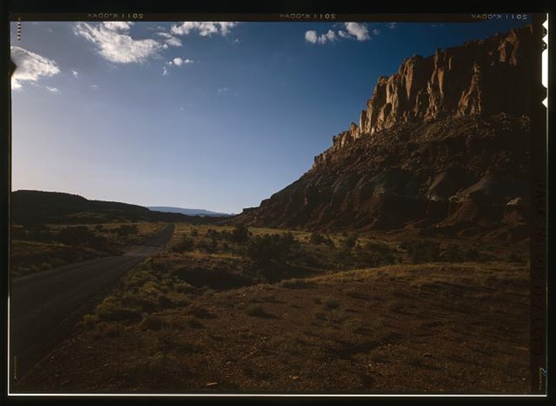
    <summary type="html"><![CDATA[<p><strong><em>At Capitol Reef National Monument, Utah, the Civilian Conservation Corps (CCC) worked tirelessly to build roads making this remote area accessible for visitors to the National Monument.</em></strong></p><img src="https://www.intermountainhistories.org/files/fullsize/8f699dd386756fc441762e509c2267b9.jpg" alt="Torrey-Boulder Road" /><br/><p>In 1937, President Franklin Roosevelt designated 37,711 acres of land in Utah as Capitol Reef National Monument. The new monument was under the jurisdiction of Zion National Park until becoming its own National Park in 1971 under President Richard Nixon. The area was also expanded to 241,000 acres, a very considerable increase in size. However, during the New Deal era of the late 1930s to early 1940s Capitol Reef was simply a small National Monument, remote, with very little infrastructure. Members of the Civilian Conservation Corps camp NM-2 (later renamed NP-6) took on the task of bringing improving infrastructure in the Monument. These men were based west of Fruita, close to Chimney Rock. </p><p>Much of what the CCC men built remains visible within Capitol Reef National Park. Two examples of this are the Fruita ranger station and a powder magazine built into the hillside. The CCC constructed the powder magazine to store the large supply of explosives they needed to quarry sandstone slabs for construction of roads, trails, and buildings within the monument. It is now listed on the National Register of Historic Places and can be seen by the many people who visit Capitol Reef. </p><p>One of the roads built by the CCC to increase access to Capitol Reef National Monument and the surrounding area was the Torrey-Boulder Road, which allowed access to the isolated town of Boulder for the first time. Except for a few scattered lodges and the small Native American population of Havasupai in the Grand Canyon, Boulder had been the last place in the United States to receive its mail by mule—as late as 1940. The road built by the CCC climbs up to 9,000 feet at points, winding its way through thick forests of Aspen and is now a part of Highway 12. The CCC built two similar roads in the area which are colloquially referred to as ‘The Million Dollar Road’ and ‘Hells Backbone Road’, names which imply their construction difficulties.</p><p><em><strong><a href="https://www.intermountainhistories.org/items/show/73">For more (including 3 images) view the original article</a></strong></em></p>]]></summary>
    <published>2017-06-12T22:55:53+00:00</published>
    <updated>2026-04-17T19:31:59+00:00</updated>
    <link rel="alternate" type="text/html" href="https://www.intermountainhistories.org/items/show/73"/>
    <id>https://www.intermountainhistories.org/items/show/73</id>
    <author>
      <name>Sarah Birt, Northern Arizona University and Hull University </name>
    </author>
  </entry>
  <entry>
    <title type="html"><![CDATA[The CCC &amp; Arches National Monument and Park]]></title>
    <summary type="html"><![CDATA[<p><strong><em>Between the years 1938-1942 the Civilian Conservation Corps (CCC) completed an impressive amount of work building bridges, trails, and roads in Arches National Monument.</em></strong></p><img src="https://www.intermountainhistories.org/files/fullsize/4d4bd60d7e1db17da38aa27f1a6dbf34.jpg" alt="Moab Canyon Wash Culvert" /><br/><p>The area which is now Arches National Park first came to the attention of the government in the early part of the 20th century. In 1929, President Herbert Hoover designated 4,500 acres of the region a National Monument and in 1938 President Franklin Roosevelt enlarged it substantially to 33,000 acres. This was the size of the area when the CCC worked there, making it a challenge to create roads, trails, bridges, and other infrastructure projects over such a vast area. In 1969, President Richard Nixon granted the area National Park status.</p><p>In nearby Moab, Utah, the government created CCC camp NP-7 in 1940 with the aim of improving the infrastructure of Arches National Monument. The men of the CCC were the first people to attempt projects such as trail building in this remote area. Their efforts in the 1940’s helped the area to become more accessible when tourism boomed during the post-World War II period. This growth, caused predominantly by increased leisure time and money along with access to automobiles, has continued to this day with Arches National Park becoming an increasingly popular choice for tourists of all types visiting the Southwest. </p><p>Those in the NP-7 camp, one of the last CCC camps in America to close down, had completed an impressive amount of work when it closed in 1942. One of the most distinctive CCC projects to look for in the park is an impressive red sandstone building near the visitor center. Other remnants include many of the trails leading to key attractions in the park, including the ones leading to Delicate Arch and Landscape Arch. In addition to this the CCC completed work on the headquarters buildings, drainage culverts and a scenic park road. </p><p>Today Arches National Park is popular with all types of tourists, from avid mountain bike enthusiasts attracted by the surrounding region's trails to curious sightseers simply wishing to take in the stunning natural beauty of the park. </p><p><em><strong><a href="https://www.intermountainhistories.org/items/show/72">For more (including 3 images) view the original article</a></strong></em></p>]]></summary>
    <published>2017-06-12T22:22:32+00:00</published>
    <updated>2026-04-17T19:31:59+00:00</updated>
    <link rel="alternate" type="text/html" href="https://www.intermountainhistories.org/items/show/72"/>
    <id>https://www.intermountainhistories.org/items/show/72</id>
    <author>
      <name>Sarah Birt, Northern Arizona University and Hull University </name>
    </author>
  </entry>
</feed>