<?xml version="1.0" encoding="UTF-8"?>
<feed xmlns="http://www.w3.org/2005/Atom">
  <title type="text">Intermountain Histories</title>
  <updated>2026-04-17T19:32:16+00:00</updated>
  <generator uri="http://framework.zend.com" version="1.12.20">Zend_Feed_Writer</generator>
  <link rel="alternate" type="text/html" href="https://www.intermountainhistories.org/"/>
  <link rel="self" type="application/atom+xml" href="https://www.intermountainhistories.org/items/browse?output=rss2"/>
  <id>https://www.intermountainhistories.org/</id>
  <author>
    <name>Intermountain Histories</name>
    <uri>https://www.intermountainhistories.org</uri>
  </author>
  <link rel="hub" href="https://pubsubhubbub.appspot.com/"/>
  <entry>
    <title type="html"><![CDATA[Life in Los Alamos: Linking the Past and Present <br />
]]></title>
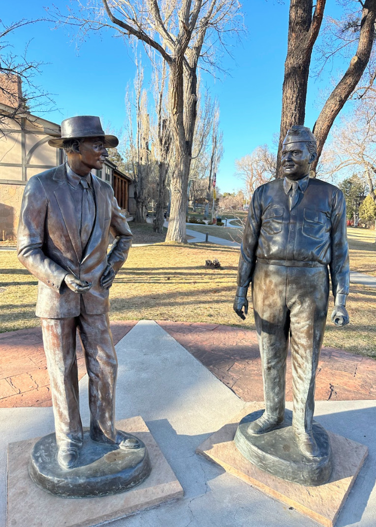
    <summary type="html"><![CDATA[<p><strong><em>Los Alamos residents in the 1940s found themselves in unusual circumstances. John von Neumann explained that, “At great expense we have gathered on this mesa the largest collection of crackpots ever seen.” Yet these people continued life under the cover of secrecy and created a community which has lasted until this day. 	</p></strong></p><img src="https://www.intermountainhistories.org/files/fullsize/a56ce2e0f40dcd7d1a6e2fe9af1ddcf0.jpg" alt="Statue of Oppenheimer and Groves" /><br/><p><span style="font-weight:400;">As the scientists and military personnel worked furiously to create an atomic weapon during the latter years of WWII, many moved to the classified town of Los Alamos, New Mexico. Because their project was shrouded in such secrecy, they were required to move themselves and their family without knowing many of the details of their new job or location. Although the civilian and academic director, J. Robert Oppenheimer, tried to make it as much of a collaborative and normal operation as possible, the nature of their assignment meant that living in Los Alamos was unique. </p>
<span style="font-weight:400;">Many scientists arrived without knowing exactly where they would be working or what they would be doing. They were not even allowed to tell their spouses what their work in the restricted laboratories entailed. Secrecy was of the utmost importance. Oppenheimer spread disinformation to nearby cities, such as Santa Fe, that they were working on an electric rocket. Mail for all scientists was addressed to Box 1663, Sandoval County, Rural. It was liable to searches and some outgoing mail was redacted for security concerns. Even phone calls were monitored—army intelligence agents were obvious in listening in on people’s private conversations. Barbed wire covered the scenic landscape and made some workers feel as though they were the ones imprisoned rather than the liberators of those in European prison camps. </p>
<span style="font-weight:400;">Despite the secrecy and sometimes oppressive security, many familiar aspects of daily life continued in Los Alamos. Many women were given clerical jobs such as secretaries or computer operators to keep them occupied while their husbands worked. Children continued to attend school and babies continued to be born. In regards to the baby boom, the military official General Leslie Groves grumbled that they were simply taking advantage of the free healthcare awarded to those in the army effort. The few movies which were allowed to play were quite popular. In a move for additional entertainment, engineers and scientists threw amateur theatricals which even featured the eminent Oppenheimer in the role of “corpse.” </p>
<span style="font-weight:400;">The setting of Los Alamos itself served as a diversion for employees and their families. Oppenheimer had picked the site of Los Alamos for its beauty and openness. He thought that it could give the scientists a sense of freedom amidst all of their restrictions. Placed on top of towering mesas flanked by green mountains and overlooking fantastic natural features, there were many opportunities for outdoor recreation. During the winter, avid skiers trekked up the nearby Jemez Mountains and skied back down to their homes. The outdoor ice rink, built in 1936, became an unofficial youth center for local children to spend their winters with friends. The warmer months brought camping, horseback riding, fishing, and hiking. Curious children and adults also explored the many nearby Ancestral Puebloan archaeological sites and ruins. </p>
<span style="font-weight:400;">Even though Los Alamos was a unique environment of brilliant scientists sequestered in the wilderness, life found a way to continue in relative normalcy. It grew out of a wartime necessity into a long-lasting community with unusual origins. Today, Los Alamos is home to around 13,000 people and a National Laboratory specializing in weapon-making for the United States government. The community maintains their engagement in many of the recreational activities that their predecessors did. The Pajarito Ski Hill and the ice rink continue to gather youth and adults during the winter months. Warmer times of the year bring outdoor sports, especially running and hiking, among the abundant natural landscape. Summer is also the ideal time for weapons testing. For seasoned Los Alamos citizens, a large explosion miles away that rattles windows and door frames is unsurprising—rarely do they suspect an earthquake.  The work and life of Los Alamos persists nearly a century after it was settled. </span>


</p><p><em><strong><a href="https://www.intermountainhistories.org/items/show/754">For more (including 5 images) view the original article</a></strong></em></p>]]></summary>
    <published>2023-09-20T19:36:59+00:00</published>
    <updated>2026-04-17T19:32:16+00:00</updated>
    <link rel="alternate" type="text/html" href="https://www.intermountainhistories.org/items/show/754"/>
    <id>https://www.intermountainhistories.org/items/show/754</id>
    <author>
      <name>Abigail Beus, Brigham Young University</name>
    </author>
  </entry>
  <entry>
    <title type="html"><![CDATA[Newspaper Rock]]></title>
    <summary type="html"><![CDATA[<p><strong><em>One of many petroglyph sites in Utah, Newspaper Rock is unique because of the large time span in which the petroglyphs were drawn. It is a look into the past lives of those who lived in Utah before us.</em></strong></p><img src="https://www.intermountainhistories.org/files/fullsize/503ebfadc22176964ceb07658bf0b8f0.jpg" alt="Newspaper Rock" /><br/><p>Newspaper Rock is located along the Scenic Creek Corridor Scenic Byway in the Bears Ears National Monument, created on the cliffs that go through all of Indian Creek Canyon. Newspaper Rock is about 24 miles northwest of Monticello and 50 miles south of Moab. The actual petroglyph site is around 200 square feet across. It is located along the main road to the Needles District of Canyonlands National Park. There is no fee to access this site, and it is open all year long. Formerly a state park, Newspaper Rock currently carries the designation of a National Monument.</p><p>The petroglyphs that cover the group of rocks collectively known as Newspaper Rock were drawn across a wide span of time ranging from 1200 to 200 years ago. The petroglyphs are thought to be drawn by a variety of people including the Ancestral Pueblo, Fremont, Basket Maker, and Navajo peoples.</p><p><span>As a hunter-gather people living around 100 CE, Ancestral Puebloans’ diet relied upon hunting. Later, they transitioned to a sedentary lifestyle and relied more upon agriculture. They occupied the southwest area of the modern-day United States until droughts destroyed their agricultural economy and forced them to move away from Utah, Arizona, Colorado, and New Mexico to other areas with more water. The Fremont also inhabited this area around the same time as the Ancestral Puebloans. Similarly, they developed agricultural practices, but hunting remained an important part of their culture until devastating droughts hit the region. By the fifteenth century, the Diné (Navajo) arrived and, like their predecessors, participated in hunting and gathering. When the Diné moved into the southwest, they adapted some of the Puebloans’ agricultural practices and cultivated corn, beans, and squash while supplementing their diet through hunting.</span></p><p><span>The Ancestral Puebloans, Fremont, and Navajos all added carvings to this rock</span> over the course of centuries. As a result, there is no linear story that can be understood from the pictures. Most of the pictures remain unidentified and uninterpreted because there is no way to discover their meaning. It is unclear why this particular rock was such a popular place for petroglyphs, but its popularity in the ancient world has made it popular again in the modern world. <span>European explorers added more names and dates, and</span> curious visitors come to see the pictures etched by ancient peoples long past.</p><p>In the Navajo language, Newspaper Rock is called <em>Tse’ Hane</em>, which means, “rock that tells a story.” What do these ancient storytellers reveal about the Native American Indians who created These mysterious images? Though there is no exact translation known for many of these petroglyphs, it is possible to infer some things about the people from their rock art. These markings, engravings, and drawings tell us about stories, hunting patterns, crop cycles, beliefs, and mythologies of their existence. Some modern Native American Indians have interpreted the drawings on the rock to include family or clan symbols, spiritual meanings, and calendar events. Images include those of animals, people, tools, and other items. We know that the drawings were compiled over time by different groups who were in the area. Earlier drawings resemble snakes, wagon wheels, lizards, footprints, and broad shouldered, animal headed people. Some we can tell were made later, depicting men on horseback, potentially referring to the coming of the Spanish and other colonizers who threatened some groups and brought prosperity to others. These petroglyphs help us add to the tales we already know about these ancient people as we build on the foundation of what we know about them from other artifacts and oral histories.</p><p><em><strong><a href="https://www.intermountainhistories.org/items/show/564">For more (including 6 images) view the original article</a></strong></em></p>]]></summary>
    <published>2021-12-18T08:33:05+00:00</published>
    <updated>2026-04-17T19:32:12+00:00</updated>
    <link rel="alternate" type="text/html" href="https://www.intermountainhistories.org/items/show/564"/>
    <id>https://www.intermountainhistories.org/items/show/564</id>
    <author>
      <name>Sarah Taylor, Sarah McCuen, Emma McLeod Lariviere, and C. Raquel Rawlings, Brigham Young University</name>
    </author>
  </entry>
  <entry>
    <title type="html"><![CDATA[Mesa Verde and the Evolution of Site Preservation and Protection]]></title>
    <summary type="html"><![CDATA[<p><strong><em>Pot Hunting at Mesa Verde led to several important laws being put into place to protect artifacts from pothunters and the public. These laws are still in place today.</em></strong></p><img src="https://www.intermountainhistories.org/files/fullsize/1c4a0c97b4698f6bd9de9101aa831e6f.jpg" alt="Cliff Dwellings" /><br/><p> President Theodore Roosevelt created Mesa Verde National Monument on June 29, 1906. The monument is located near Cortez and Mancos, Colorado. Ancestral Puebloans inhabited Mesa Verde from 6000 BCE. to about 1300 CE. Their broader cultural group encompassed most of northern Arizona, northern New Mexico, southwestern Colorado and southern Utah. </p><p>Fathers Escalante and Dominguez were the first Europeans to record seeing Mesa Verde on their way to what is now California. The ruins then went unnoticed until geologist Ferdinand V. Hayden led an expedition across southern Colorado in 1874. When he heard about cliff houses nearby, instead of going to the ruins himself, Hayden sent his expedition photographer, William H. Jackson, to photograph them. Stunned by what he saw in the photographs, Hayden returned the next year to document the ruins and the artifacts inside them.</p><p>In 1888, Richard Wetherill and his brothers who lived in the area found the ruins while looking for lost cattle; they explored them and began collecting artifacts. By 1890 Wetherill had built a substantial collection from all over Mesa Verde and began to sell to collectors and museums. Also during this time, Wetherill started taking tourists to Mesa Verde. In 1891, he led a Swedish scientist, Gustav Nordenskiöld, to the ruins. During his time exploring the ruins, Nordenskiöld developed a systematic method for excavating the ruins and how to record artifacts. Afterwards, Nordenskiöld removed the objects from the site. During his excavation, the Swede noticed the pottery went from painted black- on- white, refined pottery to simple and crude pottery. This pattern led Nordenskiöld to notice how the Anasazi changed over time through their pottery. </p><p>When Nordenskiöld tried to return to Sweden with his large collection, customs agents stopped and detained him. Undeterred, Nordenskiöld negotiated his release when he pointed out that the US did not have any laws preventing him from taking the objects out of the country. After Nordenskiöld returned to Sweden, Wetherill stopped taking tourists to Mesa Verde to focus on his excavation at Chaco Canyon. Tourists continued to visit the sites for the next decade until archaeologist and preservationist Edgar Lee Hewitt fought to make Mesa Verde a national monument. Hewett was instrumental in lobbying congress to create  the Antiquities Act of 1906 which led to President Roosevelt’s declaration of Mesa Verde a national monument.</p><p>Although the Antiquities Act was the first step in protecting artifacts in national monuments, pot hunting continued at Mesa Verde as well as at other sites such as Canyon de Chelly and Chaco Canyon. The punishment of taking a pot or artifact from federal lands today is punishable by a year in jail and up $10,000 in fines.</p><p><em><strong><a href="https://www.intermountainhistories.org/items/show/64">For more (including 3 images) view the original article</a></strong></em></p>]]></summary>
    <published>2017-06-06T21:33:44+00:00</published>
    <updated>2026-04-17T19:31:59+00:00</updated>
    <link rel="alternate" type="text/html" href="https://www.intermountainhistories.org/items/show/64"/>
    <id>https://www.intermountainhistories.org/items/show/64</id>
    <author>
      <name>Alexandria O&amp;#039;Hara, Northern Arizona University</name>
    </author>
  </entry>
</feed>
