<?xml version="1.0" encoding="UTF-8"?>
<feed xmlns="http://www.w3.org/2005/Atom">
  <title type="text">Intermountain Histories</title>
  <updated>2026-04-17T19:32:20+00:00</updated>
  <generator uri="http://framework.zend.com" version="1.12.20">Zend_Feed_Writer</generator>
  <link rel="alternate" type="text/html" href="https://www.intermountainhistories.org/"/>
  <link rel="self" type="application/atom+xml" href="https://www.intermountainhistories.org/items/browse?output=rss2"/>
  <id>https://www.intermountainhistories.org/</id>
  <author>
    <name>Intermountain Histories</name>
    <uri>https://www.intermountainhistories.org</uri>
  </author>
  <link rel="hub" href="https://pubsubhubbub.appspot.com/"/>
  <entry>
    <title type="html"><![CDATA[Mignon Richmond: First Black Woman College Graduate in Utah]]></title>
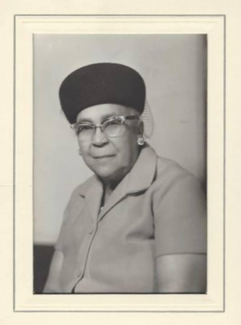
    <summary type="html"><![CDATA[<p><strong><em><span style="font-weight:400;">In 1921 Mignon Barker Richmond became the first African American woman to graduate from college in Utah and went on to become a community organizer and civil rights activist.</span></em></strong></p><img src="https://www.intermountainhistories.org/files/fullsize/8b40389c2ee054bc94fe17722f9e1b3b.jpg" alt="Mignon Barker Richmond" /><br/><p><span style="font-weight:400;">Mignon Barker Richmond was born on April 1, 1897 in Salt Lake City to William Barker and Mary Alice Reagan Barker. She attended Utah Agricultural College, now known as Utah State University, in Logan, Utah, graduating in 1921 with a degree in home economics. She persisted in spite of gross racism from her professors and peers, and participated in the Empyrean Club, a group of women that discussed contemporary problems and events, becoming its secretary-treasurer in her senior year. Following graduation, she faced difficulties finding a job in her field of study due to racial discrimination, and only after 27 years was she able to obtain work in her field of study, working first as a laboratory technician, and later as a school lunch supervisor at the University of Utah Stewart School from 1948 to 1953, and was afterwards hired to start home-living classes for the Utah State Industrial School. </span>
<span style="font-weight:400;">During this period she was active in the National Association for the Advancement of Colored People (NAACP) and the Young Women’s Christian Association (YWCA), and in 1957 she became the YWCA Food Services Director in Salt Lake City, where she stayed until her retirement in 1962 at the age of 65. Later, during president Lyndon Johnson’s administration, she became the head of the Women’s Job Corps and chairwoman of Project Medicare Alert. During her work with the Salt Lake chapter of the NAACP, she co founded the Nettie Gregory Center, a venue for minority youth to be involved in recreation in Salt Lake City, as well as on boards for the Utah Community Service Council and the Women’s Legislative Council, where she helped create legislation to fight poverty. After receiving several awards for her community service and commitment to education and civil rights, she died at the age of 86 on March 10, 1984. Many organizations including the Salt Lake Branch NAACP, Trinity AME Church, and Calvary Baptist Church came together to dedicate Richmond Park in Salt Lake City in 1984, and commissioned a plaque describing Mignon Barker Richmond as an educator, civil leader, and humanitarian.</span></p><p><em><strong><a href="https://www.intermountainhistories.org/items/show/874">For more (including 3 images) view the original article</a></strong></em></p>]]></summary>
    <published>2024-11-02T22:24:37+00:00</published>
    <updated>2026-04-17T19:32:20+00:00</updated>
    <link rel="alternate" type="text/html" href="https://www.intermountainhistories.org/items/show/874"/>
    <id>https://www.intermountainhistories.org/items/show/874</id>
    <author>
      <name>Morgon George, Utah State University</name>
    </author>
  </entry>
  <entry>
    <title type="html"><![CDATA[Dorothy McKibbins: The Gatekeeper of Los Alamos ]]></title>
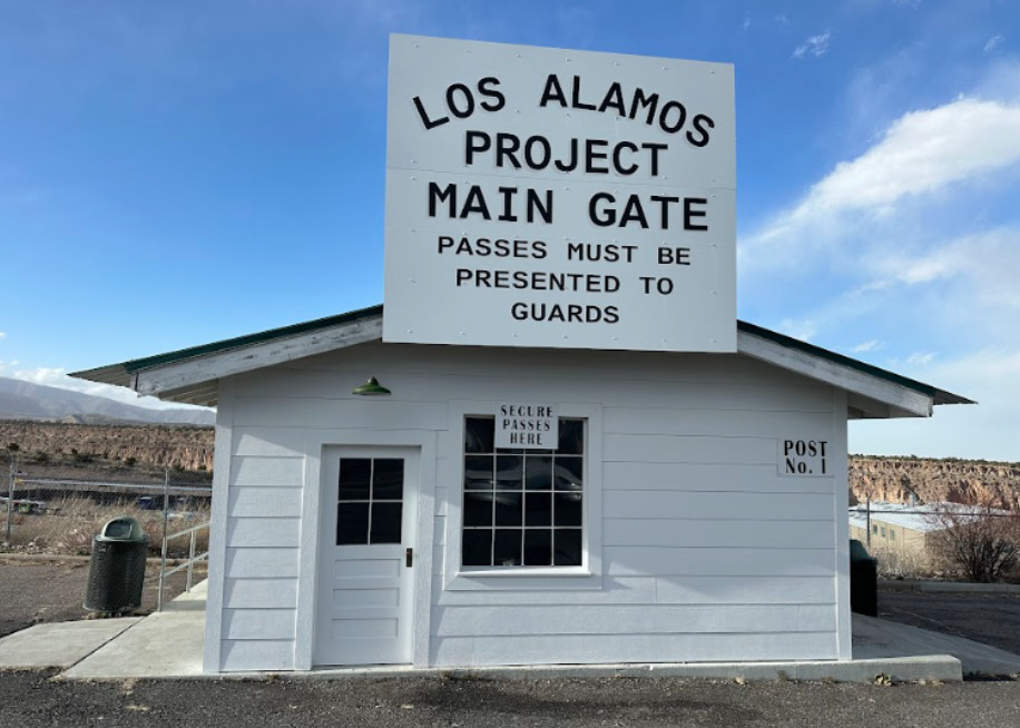
    <summary type="html"><![CDATA[<p><strong><em>The Manhattan Project would not have been possible without the efforts of Dorothy McKibbin, the Gatekeeper of Los Alamos. From attaining marriage licenses to transferring phone calls, Dorothy McKibbin was an integral and diversely skilled cog in the large machine of building the first nuclear weapons. </p></strong></p><img src="https://www.intermountainhistories.org/files/fullsize/5c401996b7cfdc416ba17d96a788fbec.jpg" alt="Los Alamos Project Main Gate Replica" /><br/><p><span style="font-weight:400;">Once General Leslie Groves and Dr. J. Robert Oppenheimer chose Los Alamos, New Mexico as the place to build the atomic bomb; hundreds of bewildered employees streamed into the nearby town of Santa Fe. Due to the confidentiality of the Manhattan Project, recruitment was difficult and details provided to the new hires were vague because of the classified nature of their work. They were told that their work would helpe war effort and be located in the scenic mesas of New Mexico, but little else. After a long train ride to the nearby town of Lamy, scientists and their families hauled their luggage through the winding streets of Santa Fe, looking for 109 East Palace Avenue—the only address they had been given. There, they were met by a simple red and blue sign reading “United States Engineer Office No. 3” and the welcoming presence of Dorothy McKibbin. </p>
<span style="font-weight:400;">In 1932, recently-widowed Dorothy McKibbin moved to Santa Fe from Kansas with her son, hoping for a new life. When she met Dr. J. Robert Oppenheimer in 1943, she found one. Oppenheimer recognized her comforting, calming, and competent presence and asked her to be a War Department secretary with unspecified duties. Like the other personnel, she only knew that her job concerned an essential war project. As she discovered after accepting the position, duties encompassed everything from disciplining Nobel laureates, receiving classified mail, enforcing security, helping lost families find the way to their new homes, and more. She was there for some of the most important moments of the project, even observing the Trinity Test from a car parked near Albuquerque. To Dorothy McKibbin, “Working at 109 was more than just a job. It was an exciting experience. Our office served as the entrance to one of the most significant undertakings of the war or, indeed, of the twentieth century.” </p>
<span style="font-weight:400;">For the entirety of the Manhattan Project she was the point of contact between the secret city and the rest of the world, earning herself the nickname of  the “Gatekeeper of Los Alamos.” After the Manhattan Project concluded, the site was renamed the Los Alamos National Laboratory, and McKibbin continued to work there until her retirement in 1963. She spent her retirement organizing community programs in Los Alamos and Santa Fe until her death in 1985. Today, a room in the Los Alamos History Museum is named in her honor, and although her office at 109 East Palace currently houses a gift shop, its original iron gate which once welcomed thousands to the secret city is on display at the Los Alamos History Museum. </span>
</p><p><em><strong><a href="https://www.intermountainhistories.org/items/show/752">For more (including 4 images) view the original article</a></strong></em></p>]]></summary>
    <published>2023-09-08T01:24:19+00:00</published>
    <updated>2026-04-17T19:32:16+00:00</updated>
    <link rel="alternate" type="text/html" href="https://www.intermountainhistories.org/items/show/752"/>
    <id>https://www.intermountainhistories.org/items/show/752</id>
    <author>
      <name>Abigail Beus, Brigham Young University</name>
    </author>
  </entry>
  <entry>
    <title type="html"><![CDATA[Bathtub Row ]]></title>
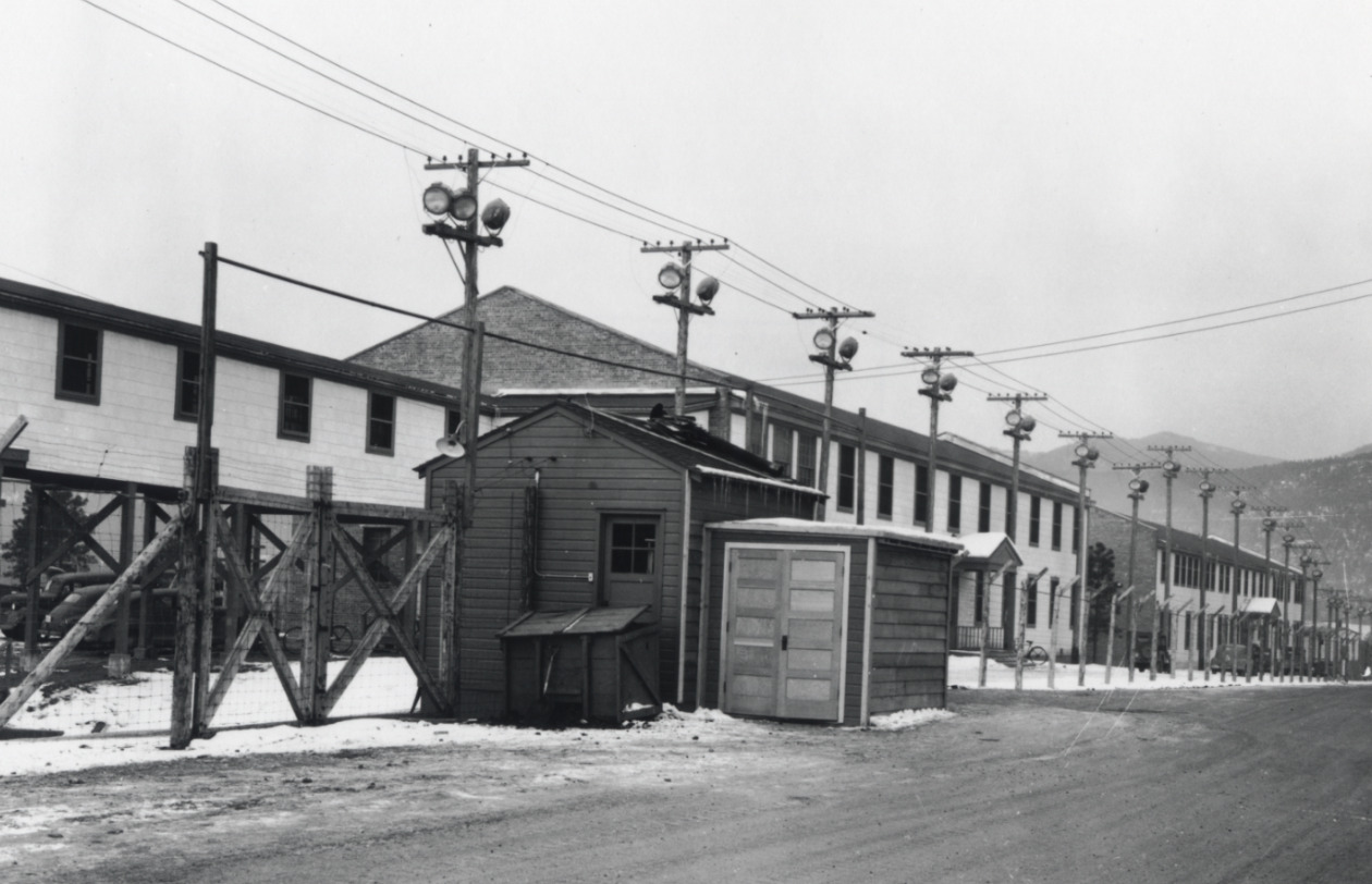
    <summary type="html"><![CDATA[<p><strong><em>As scientists raced to build the first atomic weapon during WWII, they were required to sacrifice their time, academic careers, energy, bathtubs, and more in the remote desert highlands of New Mexico. </p></strong></p><img src="https://www.intermountainhistories.org/files/fullsize/81238fa6d58203850c43f89b67708cda.jpg" alt="Los Alamos Infrastructure " /><br/><p>As World War II raged into the 1940s, each country in the war was an avid participant in the race for scientific advancement. With such high stakes, the United States invested two billion dollars—over $33 billion today—in the creation of the atomic bomb. This massive project was dubbed the Manhattan Project, after its headquarters in New York, despite largely taking place in the remote highlands of New Mexico.</p><p><span style="font-weight:400;">While the United States had fiscal resources to invest in the project, they did not have much time. Both the Germans and the Soviets were developing their own nuclear weapons, and it seemed that whoever discovered how to harness the power of the atom first would win the war. The speed and urgency of the venture inevitably meant that some details were overlooked. Construction teams were tasked with building housing for thousands of men, women, and children in the remote deserts of New Mexico in total secrecy. The workmanship of many of these early houses was shoddy at best. Project builders were not only short on time, but materials. In particular, iron was a scarce resource and largely reserved for the war effort. Understandably, it could hardly be used for iron bathtubs. Due to these factors, the majority of scientists, military personnel, and their families lived in small, relatively iron-less, hastily built homes with only a few variations of bathroom fixtures—none of which included bathtubs. </span>
<span style="font-weight:400;">Only a single row of houses had the luxury of bathtubs because they were built before the war and had originally belonged to teachers of a secondary boys’ ranch school. These “master cottages” were some of the only buildings already built when the government bought the land and were a coveted luxury. Reserved for men such as Nobel-Prize winning Englishman Sir James Chadwick, explosives expert George Kistiakowsky, bomb designer Max Roy, ordnance director William S. “Deak” Parsons, and head scientist Robert J. Oppenheimer, bathtubs were a sign of prestige in this secret New Mexico town. According to local legend, Alice Kimball Smith, wife of scientist Cyril Smith, coined the term “bathtub row.” This effectively differentiated between the comfortable ranch school homes with bathtubs and those of government construction with showers.</p>
<span style="font-weight:400;">Despite the obvious disparity, many on Bathtub Row were willing to share their good fortune. Robert Oppenheimer was reportedly a generous host who invited many in the community into his home for classified discussions, drinks, and dinner parties. Ordnance director William S. Parsons’ home was fortunate enough to have two bathtubs. He often allowed military men to use them if they were injured and unable to stand for long periods of time under a shower. These bathtubs were also used to entice babysitters who would be rewarded with a relaxing soak in their neighbor’s home in exchange for an afternoon taking care of the owners’ children.</p>
<span style="font-weight:400;">Today, these houses are privately owned, but remain part of the Los Alamos National Historical Landmark District. In 2007, the Los Alamos population petitioned to change the street name from 20th to Bathtub Row. The community has continued to embrace this humorous anecdote from WWII through naming the local brewing co-op after the iconic row of houses. It stands as a reminder of the simple luxuries many relinquished in favor of supporting the American effort during WWII. </span>

</p><p><em><strong><a href="https://www.intermountainhistories.org/items/show/751">For more (including 10 images) view the original article</a></strong></em></p>]]></summary>
    <published>2023-09-08T00:39:58+00:00</published>
    <updated>2026-04-17T19:32:16+00:00</updated>
    <link rel="alternate" type="text/html" href="https://www.intermountainhistories.org/items/show/751"/>
    <id>https://www.intermountainhistories.org/items/show/751</id>
    <author>
      <name>Abigail Beus, Brigham Young University</name>
    </author>
  </entry>
  <entry>
    <title type="html"><![CDATA[Lake Lowell: Transforming Treasure Valley]]></title>
    <summary type="html"><![CDATA[<p><strong><em>The Reclamation Act of June 17, 1902, aimed to create proper irrigation systems that could provide water access for residents of western states. Lake Lowell was one of those projects.</em></strong></p><img src="https://www.intermountainhistories.org/files/fullsize/8dafc9cce562e3302960bcf13f35ebe2.jpg" alt="Building up" /><br/><p>Under the direction of the 1902 Reclamation Act—congressional legislation intended to irrigate western states and provide greater access to water—the Bureau of Reclamation approved and developed Lake Lowell, starting in 1902 and finishing in 1909. Three dams—the Upper, Middle, and Lower Embankments (embankments are walls of earth or stone built to prevent a river from flooding an area)—surround a natural depression southwest of Nampa, Idaho to form the lake. A fourth wall, called the East Embankment, was added later to protect farmsteads on the eastern end of the reservoir.
In the irrigation off-season, the Boise River Diversion Dam and New York Canal provide most of Lake Lowell’s volume, discharging water intp the upper end of the lake, where there is a capacity ranging from 12.7 feet on the Middle Embankment to 65 feet on the Upper. During the irrigation season, Lake Lowell becomes one of the major irrigation providers for Canyon County agriculture. With the capacity to irrigate over 200,000 acres of land, it is one of the American West’s largest off-stream reservoirs.
As with many other western irrigation projects, Lake Lowell presented a significant opportunity for economic growth and restructured the relationship between people and their environment. Along with other government investment projects that opened the area to construction and farming, irrigation attracted migrants from the Midwest who worked as laborers to develop the dam and as farmers to till the land. In 1900, the census counted 161,772 people living in Idaho; by the 1920 census, the population had more than doubled to 431,866 people. This growth was sharpest in southwestern Idaho, which grew by 130% during this twenty-year period as agricultural and ex-urban communities transformed Treasure Valley into fertile land. Lake Lowell made that change possible.
In addition to serving local farms, towns, and cities, Lake Lowell also plays a role in how people and other living things interact with the region’s nature. The lake hosts the Deer Flat Reservoir, one of the oldest refuges in the National Wildlife Refuge System. As for humans in nature, Lake Lowell is a popular destination for numerous outdoor activities, including boating, swimming, fishing, birdwatching, hiking, and hunting.</p><p><em><strong><a href="https://www.intermountainhistories.org/items/show/629">For more (including 5 images) view the original article</a></strong></em></p>]]></summary>
    <published>2022-06-30T21:27:42+00:00</published>
    <updated>2026-04-17T19:32:13+00:00</updated>
    <link rel="alternate" type="text/html" href="https://www.intermountainhistories.org/items/show/629"/>
    <id>https://www.intermountainhistories.org/items/show/629</id>
    <author>
      <name>Legna Roximar Morales, College of Idaho</name>
    </author>
  </entry>
  <entry>
    <title type="html"><![CDATA[Long Valley Finnish Church]]></title>
    <summary type="html"><![CDATA[<p><strong><em>The Long Valley Finnish Church was a crucial meeting place for Finnish Lutherans. The building continues to serve and educate the people of the area to this day.</em></strong></p><img src="https://www.intermountainhistories.org/files/fullsize/fe4390b086e8d75b5c5f75d81466c973.jpg" alt="Lasting legacy" /><br/><p><span>Following decades of struggle for independence from the Russian government and its anti-Finnish policies, numerous Finns left their homeland to migrate to the United States in search of religious and political freedom. Between 1900 and 1930, about 85 Finnish families traveled to Idaho and settled in Long Valley, southwest of Clear Creek and southeast of Hurday Creek. The Long Valley Finnish settlement became the largest Finnish community in the state of Idaho, centered around the Lutheran Church and celebrating Finnish culture. </span>
<span>These Finnish settlers took advantage of the 1862 Homestead Act, which allowed any adult citizen or intended citizen who had never fought against the United States government to claim 160 acres of land surveyed by the government. Contrary to popular perception, this land was not empty but had long been occupied by the Shoshone and Nimíipuu. The Homestead Act required the new property owners to live on and cultivate the land, leading most of the Long Valley Finns to become farmers or loggers.</span>
<span>The Lutheran Church was the foundation of the Long Valley Finnish community.  This community of worship established a physical location in 1917, when they built the Long Valley Finnish Church on an acre plot in Lake Fork, Idaho. The main hall of the church is forty-eight feet long and twenty-six feet wide, supplying ample space to worship and gather. The Long Valley Finnish Church was a cornerstone for the Finns as a place for the people to worship according to their Lutheran faith and come together as a community. People living in the area still use the chapel to this day for select worship services, funerals, and more.</span>
<span>Long Valley Finnish Church stands approximately 350 feet southwest of the Finnish cemetery where the majority of Finnish immigrants were laid to rest. Finnish Ladies Aid Society maintains and preserves the building, which today is one of the only remaining artifacts in Idaho representing the Finnish migration to the state.</span></p><p><em><strong><a href="https://www.intermountainhistories.org/items/show/626">For more (including 3 images) view the original article</a></strong></em></p>]]></summary>
    <published>2022-06-26T02:56:16+00:00</published>
    <updated>2026-04-17T19:32:13+00:00</updated>
    <link rel="alternate" type="text/html" href="https://www.intermountainhistories.org/items/show/626"/>
    <id>https://www.intermountainhistories.org/items/show/626</id>
    <author>
      <name>Cooper Leaf, College of Idaho</name>
    </author>
  </entry>
  <entry>
    <title type="html"><![CDATA[The Big Burn of 1910]]></title>
    <summary type="html"><![CDATA[<p><strong><em>The summer of 1910 was very dry in the northwest United States, with absolutely no precipitation May through July. The resulting fire was so destructive that Americans named it “the Big Burn.”</em></strong></p><img src="https://www.intermountainhistories.org/files/fullsize/1aac363c55b106acdcbdfdad043cc9a0.jpg" alt="Scars of Wallace, ID" /><br/><p>In the summer of 1910, every step through the forests in the Bitterroot Mountains between Idaho and Montana could meet with a resounding <em>crunch</em> from the arid twigs and leaves. The season had been extremely dry, with no rain at all from May through July.
On the night of July 26, a lightning storm swept across the Bitterroots. Thunder roared through the valleys, but there was no rainfall. By the following morning, nearly a thousand fires had sprung up around the region, sparked by the lightning. In the following weeks, even more blazes emerged. Sparks, thrown by trains rumbling through the dense forest had no trouble lighting the desiccant woodland, adding to the crisis. By the middle of August, there were 2,500 separate fires burning in Idaho and Montana.
On the morning of August 20, a breeze picked up through the Coeur d’Alene National Forest and the St. Joe Mountains. The wind gradually intensified throughout the day. Before the firefighters knew it, they were dealing with gusts of up to 70 mph. Hurricane-like winds pushed together hundreds of fires. By this point, there was virtually no hope of containing the fire. The Big Burn had started.
The dry wilderness was like an endless source of fuel, and he giant blaze devoured everything in its path. Flaming trees were pulled from the ground and tossed like mere sticks while dry timber caught fire and instantly exploded into a ball of sparks. Firefighters that survived reported that it was near impossible to outrun the heat because the inferno moved at the speed of a charging horse. Those with a head start had a chance of survival; most others did not. Over the course of two days, the Big Burn torched three million acres of land. A third of Wallace, Idaho—a town of three thousand people—burned to the ground. The fire almost completely leveled the mining towns of Grand Forks, Idaho and Taft, Montana. Eighty-six people died, seventy-eight of whom were firefighters.
It was soon clear that the Big Burn was the most destructive fire the United States Forest Service had ever seen. The fire would also be recognized as the most significant wildfire emergency because of its deep impact on future forest policies. The disaster inspired a wave of priority and policy concerning national land. The incredible loss of life and forest showed the Forest Service needed serious recognition from the people. Donations poured in, and Congress doubled the organization’s budget. Parks and forest stations hired more staff and established resources in preparation of another wildfire catastrophe. The disaster of 1910 imprinted on the nation how dangerous fire could be; it was a lesson learned at incredible human cost.</p><p><em><strong><a href="https://www.intermountainhistories.org/items/show/623">For more (including 5 images) view the original article</a></strong></em></p>]]></summary>
    <published>2022-06-25T06:54:15+00:00</published>
    <updated>2026-04-17T19:32:13+00:00</updated>
    <link rel="alternate" type="text/html" href="https://www.intermountainhistories.org/items/show/623"/>
    <id>https://www.intermountainhistories.org/items/show/623</id>
    <author>
      <name>Brennen Donahue, College of Idaho</name>
    </author>
  </entry>
  <entry>
    <title type="html"><![CDATA[Aryan Nations in Coeur d’Alene, Idaho: Is the state “Too Great for Hate?”]]></title>
    <summary type="html"><![CDATA[<p><strong><em>Coeur d’Alene is the largest city in Northern Idaho, nestled among the Rocky Mountains and a picturesque lake. It was also home to a major compound of the Aryan Nations.</em></strong></p><img src="https://www.intermountainhistories.org/files/fullsize/2da7685c12ed5a2ea90e86e36e9487ae.jpg" alt="Founder of the Aryan Nations" /><br/><p>From the early-1970s arrival of Aryan Nations leader Richard Butler, to the March 2020 Idaho House’s failed vote for a “Too Great for Hate” specialty license plate, the state of Idaho has in recent years struggled over both the presence and meaning of modern white supremacy within its borders. Shortly after moving to Idaho, Butler established an Aryan Nations headquarters in rural Kootenai County on a twenty-acre site just north of Coeur d’Alene. Butler used funding he had saved and donations from fellow worshippers to begin holding services for his own congregation of the Church of Jesus Christ-Christian, a group founded in the 1940s that promulgated white supremacy and antisemitism. Butler’s compound included an adjoined print shop for publishing books, fliers, posters, and pamphlets filled with racist propaganda and antisemitic caricatures. The group led parades that gathered large crowds of youths in downtown Coeur d’Alene alongside annual summits at the compound. In the mid-1990s, the Aryan Nations began running its own website, one of the first dedicated sites for recruiting white supremacists. The religious tenor of Butler’s compound was a major draw for many who saw him as a prophetic individual, and he claimed a religious freedom right to spread his message of hate. From this headquarters, Butler preached white supremacy and exclusion to his followers, making the area synonymous with white supremacy.
However, many residents of Coeur d’Alene felt distressed at Butler’s growing presence. In 1981, Butler’s followers and rivals engaged in violent conflict, and someone defaced a local Jewish restaurant with antisemitic grafitti. This brought the compound and the town to the attention of the Kootenai County Task Force on Human Relations. The brainchild of local activists Tony Stewart, Norman Gissel, and Marshall Mend, the task force rallied locals to advocate against hate by using community outreach programs to speak against white supremacy and by intervening in disputes involving Butler and his supporters.
The advocacy group finally made headway when they won a $6.3 million lawsuit against Butler’s group for violating local codes. Stewart, Gissel, and others involved in that campaign were loath to offer their strategy as a solution for other cities, but they say their approach might be one way to address white supremacy in the US and around the world. Bankrupted by the suit, the Aryan Nations lost possession of their local property. Idaho firefighters used the compound buildings for arson investigation training, eventually burning down every structure.
The Carr Foundation later purchased the land and gifted it to the North Idaho College Foundation on the condition that they redevelop it into a “peace park.” However, in 2019 NICF obtained the Carr foundation’s permission to instead sell the land in a favorable market to fund an endowment for human rights education.
The task force’s victory over the Aryan Nations does not mean the struggle against white supremacy has concluded. Coeur d’Alene remains a town of mixed emotions between those who allow racism to flourish and those who believe Idaho can be “too great for hate.”</p><p><em><strong><a href="https://www.intermountainhistories.org/items/show/622">For more (including 3 images) view the original article</a></strong></em></p>]]></summary>
    <published>2022-06-25T05:20:37+00:00</published>
    <updated>2026-04-17T19:32:13+00:00</updated>
    <link rel="alternate" type="text/html" href="https://www.intermountainhistories.org/items/show/622"/>
    <id>https://www.intermountainhistories.org/items/show/622</id>
    <author>
      <name>Omotayo Akingba, College of Idaho</name>
    </author>
  </entry>
  <entry>
    <title type="html"><![CDATA[Cecelia Weiss, Female Homesteader<br />
]]></title>
    <summary type="html"><![CDATA[<p><strong><em>“Disregarding whatever pecuniary gain there may be, it is a real inspiration to be part of a modern pioneer colony conquering the wilderness. At least it is an inspiration in the retrospect.” Cecelia Weiss recognized and exhibited the determination and grit required of a homesteader in the desert mountains of southern Utah.</p></strong></p><img src="https://www.intermountainhistories.org/files/fullsize/ae6547733ba3c480b60048add163e233.jpg" alt="Cecelia and the Piano Box
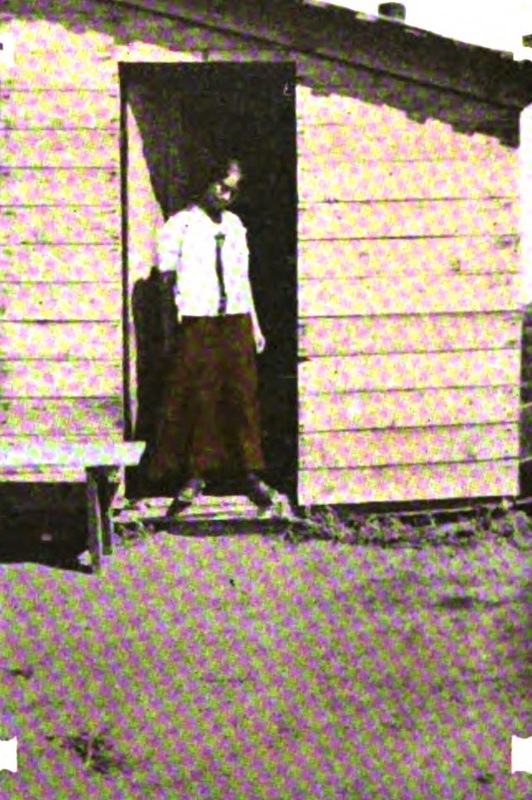
" /><br/><p>With the introduction and improvement of dry farming in the late nineteenth century, land previously considered worthless could suddenly be used. Land fever took hold of many prospective homesteaders, including Cecelia Weiss. Following the lead of her sister, in 1912 Cecelia filed for 320 acres of sagebrush in Iron County of southwestern Utah. With neighboring claims and most others in the region filed by men (only two of whom had wives), they quickly became known as “The Girls.” The two depended on one another and Cecelia recalled, “Without my sister’s companionship I think I would have deserted before the first season was half over.”</p><p>Upon acquiring her land, Cecelia hired out the building of a simple home. It was “not entirely weather-proof, but as it rarely rained in summer it afforded sufficient protection.” Cecelia was spared the “privilege of naming [her] residence.” It had scarcely been completed when a homesteader passed by, remarking that the “piano box” was finished and the “nickname clung to it ever since.”</p><p>In her accounts, Cecelia wrote, “my 320 acres do not support me — yet. I support them.” Establishing a home and a farm was no simple, or cheap, task. Cecelia returned to the city every winter, during the five month furlough allowed under homestead law, to earn the necessary funds to continue work in the summer. A Russian immigrant, she quipped that, unlike in her home country, “there are no relief commissions for girl homesteaders, and the Red Cross pays no attention to them.”</p><p>Together, the sisters worked on improvements for their land. There was no running water for miles, so they were dependent on a neighbor who could afford the expense of digging and establishing a well. Cecelia wrote, “Until I had to walk a mile and a half and carry every drop I had no conception of the value of water.” Out of necessity, “water conservation became a religion.” Putting up fences was “always one of the worst jobs of a homesteader.” When Cecelia and her sister first began digging post holes and setting the posts, they could only manage one in the morning and one in the evening, with their best effort and leaving them exhausted. Before long though, they increased to ten in the morning and ten more at night. Together, they set 600 posts and saved $75 that it would have cost to hire the work out. </p><p>To meet ownership requirements for the land, Cecelia needed to cultivate 40 acres. She paid cash for the heavy labor of clearing, plowing, seeding, and hauling. It was a helpful arrangement, but, worse than increasing her costs, it added to her “hours of leisure.” She despised the abundant spare time, writing, “I never knew how much time there is in the world, how it refuses to be prodded and hurried in its snaily crawl, until I contracted with Uncle Sam to spend seven consecutive months in the sagebrush, with the nearest neighbor almost out of sight and not sufficient work to make me forget the heat.”</p><p>Her garden became a “source of great delight.” The arid soil was not in great condition for growing, and she had to compete with rabbits and gophers, but what she was able to raise was a help. Food became less of an issue when a store was established in the nearby town, Beryl.</p><p>Even with her sister nearby, homesteading could be lonely. “In the sagebrush,” Cecelia commented, “It is not sufficient that [a young woman] should avoid evil itself; she must avoid the appearance of evil.” She records having to be careful that if a young man came to call, they would sit outside on “a hard wooden bench in the broiling sun” because it was not proper to invite him inside her one bedroom home alone. Cecelia felt “handicapped by the fear of gossip and scandal” that would “spring up overnight without provocation” in a place “where folks have nothing to do for recreation but scan the empty miles and sit and think about their neighbor.” A young girl like Cecelia, without the protection of a chaperon, made “the best material for such stories.” </p><p>Life was “not all thirst, desolation and dreariness” and, “in spite of everybody,” they made time to enjoy themselves. Cecelia found “many congenial friends” among the other settlers. Trips to call on neighbors, when managed, were all day affairs because “distances between homes [were] too great to be taken lightly” and to be travelled during midday heat. Parties “in the land of hope and thirst” were just as exciting and enjoyable as those in the city. They also often served additional practical purposes. When a big job or task was at hand, one might send for friends and neighbors to make light work of it. Food and festivities would take place after its completion. </p><p>In 1916, Cecelia received the title to her land. If she chose to sell, she could have made a neat profit of $2,200, but that was not what Cecelia wished for. She “would rather make a real farm out of the sagebrush tract.” While others saw the patent as an end goal, to her it only marked the beginning, a continuation of a dream. She wrote, “It has taken pluck to stick to the venture and see it through. There have been times when it has been very hard to stay, but I have never thought of quitting.” To develop a farm from raw land took “money, grit, perseverance, and self-denial,” but “in spite of drouth and loneliness, this plucky girl ‘won through.’”</p><p><em><strong><a href="https://www.intermountainhistories.org/items/show/458">For more (including 3 images) view the original article</a></strong></em></p>]]></summary>
    <published>2021-02-07T06:05:00+00:00</published>
    <updated>2026-04-17T19:32:09+00:00</updated>
    <link rel="alternate" type="text/html" href="https://www.intermountainhistories.org/items/show/458"/>
    <id>https://www.intermountainhistories.org/items/show/458</id>
    <author>
      <name>Anna Bailey, Brigham Young University </name>
    </author>
  </entry>
  <entry>
    <title type="html"><![CDATA[Brewing a Brew Culture]]></title>
    <summary type="html"><![CDATA[<p><strong><em>Though prohibition in Fort Collins ended in 1969, the breweries that would become a staple in Western college town culture did not arrive for another twenty years. It was Fort Collins’ status as a college town and location near the pristine waters of the Poudre River that drew brewers to the area.</em></strong></p><img src="https://www.intermountainhistories.org/files/fullsize/2300d113185bf834094ae68a4ed879af.jpg" alt="Old Town Square" /><br/><p>As one of Fort Collins’ oldest breweries, Coopersmith’s Pub & Brewing is a cultural mainstay of the college town. It opened in 1989 along with several other breweries that followed the opening of the Anheuser-Busch brewery in 1988, after a law changed allowing Fort Collins to produce and sell beer. Upon learning of the change in law, Coopersmith's founder Scott Smith took advantage of the opportunity, opening the pub & brewing facility with investors’ assistance. Though several breweries have since opened and closed, Coopersmith’s has survived through the years as a successful model to other similar businesses. Front Range Historian Brea D. Hoffman even suggests that Coopersmith’s helped to make Old Town Fort Collins a popular local destination. Now, the brewery employs over one hundred people with around twenty house beers on tap.</p><p>But brewing was not always the industry it is today. It took more than a decade after prohibition ended for the city to even consider allowing breweries to set up shop in Fort Collins, and almost two decades until breweries were actually established. One of the bigger concerns for both the brewers and the locals was water usage. Like the rest of the West, Fort Collins and Northern Colorado face challenges when it comes to water access. For breweries, water is an integral part of their process; water supports the yeast which feeds off of sugar and turns it into alcohol. In order for beer to obtain its natural flavor, the water from which the process begins needs to be free of bacteria and pollutants that can alter the flavor of the beer, leading many breweries to spend considerable funds on treating their water. The City of Fort Collins invests attention to the health of its natural environment and water sources, and has been doing so since the 1970s. Since both the city and the breweries were and continue to be so concerned with water, these entities have worked together on shared goals toward water conservation. This sort of local collaboration was a necessity for brewers in Fort Collins, for the city’s location on the Poudre River made it and ideal place for brewers to set up shop.</p><p>Breweries also received pushback from more conservative residents, who were concerned with the kind of culture that would come with an industry centered around alcohol consumption. “The city was dry until ’69,” said Coopersmith’s President, Dwight Hall, who explained what he thought about the cultural changes it took for breweries to take off. “But I’ll go back to CSU being such a moderating influence on the community. It brings people in with new perspectives.” </p><p>“It’s the rebirth of a historic tradition,” founder Scott Smith was quoted as saying in the Coloradoan. “Brew pubs aren’t a fad.” Though Fort Collins might have held onto prohibition longer than most, changing attitudes throughout the region helped bring brewery culture to a once dry city.</p><p><em><strong><a href="https://www.intermountainhistories.org/items/show/135">For more (including 4 images) view the original article</a></strong></em></p>]]></summary>
    <published>2018-02-01T20:07:47+00:00</published>
    <updated>2026-04-17T19:32:00+00:00</updated>
    <link rel="alternate" type="text/html" href="https://www.intermountainhistories.org/items/show/135"/>
    <id>https://www.intermountainhistories.org/items/show/135</id>
    <author>
      <name>Davis Brady, Jason Caskey, and Elaine Gay, Colorado State University</name>
    </author>
  </entry>
  <entry>
    <title type="html"><![CDATA[A Thirst for Freedom in a Dry Town]]></title>
    <summary type="html"><![CDATA[<p><strong><em>A long-brewing issue, the Fort Collins, Colorado City Council voted to permit the sale of beer, wine, and liquors on April 8, 1969 and passed Ordinance No. 14. The voices of the community, including local businessmen, politicians, and the Colorado State University student population, were integral in influencing this decision.</em></strong></p><img src="https://www.intermountainhistories.org/files/fullsize/a0ecee72beabc8b0b2187f586ba3d78b.jpg" alt="Thomas Bennett" /><br/><p>The repeal of prohibition in Fort Collins was not easily completed. In 1969 a petition was circulated for the third time to end prohibition. First in 1961 and again in 1965, the petition had been defeated due to strong moral opposition from religious organizations. Yet, as Dr. Thomas Bennett, Mayor of Fort Collins from 1967 to 1968 pointed out, there were two liquor stores within city limits that held liquor licenses from Larimer County. Outside city limits, there were establishments like Ladd’s Covered Wagon. In 1961, owner Lloyd Ladd was granted a liquor license from Larimer County for his restaurant just north of Fort Collins. Fort Collins residents who wished to drink had several options to do so. </p><p>Dr. Thomas Bennett stepped down as mayor of Fort Collins in 1968 to serve as a councilman for the city and worked with others to end prohibition. Dr. Bennett felt passionately this was the moment to repeal prohibition. His primary argument was based on economics. The numerous bars and restaurants at the edge of city limits were proof of the profitability of alcohol sales. A new revenue stream, and the local jobs bars and liquor stores would generate, were appealing to the city council and the local community. Another source of pressure on the city council was the increase in student enrollment, specifically military veterans on the GI Bill, at Colorado State University (CSU). The 1968 Beer-In at CSU, referenced in the previous article, spoke volumes about the attitudes of college students towards prohibition. Two other college towns along the Front Range area were also in the process of repealing their own long-standing prohibition laws: Boulder, repealed in 1967 and Greeley in 1969. </p><p>The first legally sold drink of spirituous liquor since 1896 was sold in Fort Collins on August 8, 1969, at 5:00 pm in the Top Restaurant, located on the top floor of the Rocky Mountain Bank and Trust building. Les Ware, the owner of the Top Restaurant, had photographers on hand to commemorate the event. Red Ferrell, owner of Campus West Liquors and Larimer County liquor inspector at the time of the Fort Collins prohibition repeal, received the first license to sell packaged liquors in the city. Nancy Kavastanjian, staff writer for The Coloradoan newspaper, interviewed Ferrell in 1977 for a piece on the end of prohibition in Fort Collins. Ferrell reflected on the growth of liquor stores within Fort Collins, commenting that he “didn’t think it was healthy for a community to have that many.” </p><p>After the repeal, the number of bars and liquor stores within city limits did increase quickly.  According to Ferrell, the saturation of the market limited individual business earnings. The moral orientation of the town was still influential, limiting large-scale production and distribution of alcohol in Fort Collins for another two decades, when once again, it was the economic appeal of new businesses and new jobs that presented themselves in the form of beer production and breweries. </p><p><em><strong><a href="https://www.intermountainhistories.org/items/show/134">For more (including 5 images) view the original article</a></strong></em></p>]]></summary>
    <published>2018-02-01T20:00:10+00:00</published>
    <updated>2026-04-17T19:32:00+00:00</updated>
    <link rel="alternate" type="text/html" href="https://www.intermountainhistories.org/items/show/134"/>
    <id>https://www.intermountainhistories.org/items/show/134</id>
    <author>
      <name>Rose Gorrell, Colton Morton, and Keanu Squire, Colorado State University</name>
    </author>
  </entry>
  <entry>
    <title type="html"><![CDATA[CSU Students Protest and Hold a &quot;Beer-in&quot; in 1968]]></title>
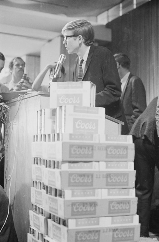
    <summary type="html"><![CDATA[<p><strong><em>Drinking culture in Fort Collins may seem pedestrian today, what with nineteen breweries dotting the city’s landscape, but the barbarous beer and bar culture of contemporary Ft. Collins was born of far more conservative roots. How did  After the repeal of the Volstead act and the resulting end of prohibition in 1933, Fort Collins maintained prohibition far longer than the majority of the country. How did the town's brew culture evolve? It all comes down to a single number: 3.2. </p></strong></p><img src="https://www.intermountainhistories.org/files/fullsize/c6befaad17dcba3f15d5ec36f11ec99f.jpg" alt="Beer-In 1968" /><br/><p>After the repeal of Prohibition in 1933, Fort Collins remained somewhat dry.  On March 22, 1933, the town passed the Cullen-Harrison Act, which allowed lawful distribution and consumption of beer that was 3.2% alcohol by weight - a fairly light brew. </p><p>Some thirty-five years later, students of Colorado State University borrowed demonstration tactics employed by civil rights activists to fight for greater student input in what they felt to be an unfair paternal relationship with university administrators—one of the first items on student protestors’ agenda was the accessibility and consumption of 3.2 beer on campus. How better to demonstrate their frustrations than staging a “beer-in” in the student center? Though the student body was far from unanimous on these matters, on Friday, October 18, 1968, the president of the Associated Students of Colorado State University (ASCSU), Doug Phelps, rallied more than 150 students in the Lory Student Center to stage a “beer-in” under the pretense of liberating the student center. </p><p>As early as November of 1965 students had expressed their displeasure with the lack of 3.2 drinking establishments in Fort Collins. A number of students attended the December 7, 1965, meeting that founded the Fort Collins Malt Beverage Association, a group comprised of city officials, existing tavern owners, and other Ft. Collins merchants. Almost exactly two years later, the ASCSU voted to poll the student body to glean student attitudes in support or opposition to the selling of 3.2 beer on campus. By February 1967, the subject had reportedly become a topic of daily discussion and debate. The State Board of Agriculture, the university governing entity, began debating the topic of 3.2 beer sales on campus by the Spring of 1968. In August of the same year, The State Board of Agriculture voted 4-1 against a request to allow the on-campus sale of 3.2 beer by the glass. On October 10, 1968, a helicopter commissioned by student body president Doug Phelps, flew over CSU campus dropping pamphlets urging students to convene for the “liberation” of the Lory Student Center as soon as possible. The resulting crowd discussed issues of student power, and Phelps announced that on October 18 at 3:00 P.M. he intended to drink beer in the student center in an act that was meant to symbolize the potential of student power to dictate Student Center policy. On October 18, 1968, Phelps and more than 150 other students made good on their promise by staging a beer-in in the Student Center Main Ballroom (only approximately 30 actually drank a beer). Students voiced their desire for beer to be sold in the newly constructed Student Center coffee shop which, perhaps not coincidentally, is the current location of the only on-campus drinking establishment, the beloved Ramskeller. </p><p><em><strong><a href="https://www.intermountainhistories.org/items/show/133">For more (including 4 images) view the original article</a></strong></em></p>]]></summary>
    <published>2018-02-01T19:51:26+00:00</published>
    <updated>2026-04-17T19:32:00+00:00</updated>
    <link rel="alternate" type="text/html" href="https://www.intermountainhistories.org/items/show/133"/>
    <id>https://www.intermountainhistories.org/items/show/133</id>
    <author>
      <name>William Bundy and Keegan Martin, Colorado State University</name>
    </author>
  </entry>
  <entry>
    <title type="html"><![CDATA[&quot;Roosevelt&#039;s Tree Friends&quot; in Idaho]]></title>
    <summary type="html"><![CDATA[<p><strong><em>Franklin Delano Roosevelt’s 1933-1942 New Deal program, the Civilian Conservation Corps (CCC), provided rural areas and communities with economic stimulus as well as natural resource protection and preservation. While receiving an education and much-needed work, young men who enrolled with the CCC interacted with communities by furnishing isolated regions with recreational areas, accessibility, and protection from forest fire and disease.</em></strong></p><img src="https://www.intermountainhistories.org/files/fullsize/156b5a0fdf3df98861aa43298382ae7d.jpg" alt="CCC Firefighters" /><br/><p>Pres. Roosevelt aimed to employ more than 300,000 men in the CCC. Just two months after the program’s implementation, 1,200 worked in Payette National Forest camps such as Gallagher and Silver Creek. Roosevelt hoped their rural camps and labor would “add to present and future values of the nation’s natural resources.” Eventually, over 18,000 total men worked to do this in Idaho’s forests.</p><p>CCC camp impacted on nearby communities was significant. CCC workers constructed roads to make rural areas accessible and undertook beautification projects to bring order to a still-rustic region. Communities around the nation valued the program for its benefits; 85.1 percent of all letters written by community members and sent to the CCC director’s office contained positive opinions regarding the program. By 1941, Payette National Forest workers, then numbering over 4,500, completed 13 bridges, 134 buildings (mostly for the Forest Service), and 131 miles of road. CCC workers created recreational areas for nearby communities, many of which still exist. In 1939, for example, 170 workers from Gallagher camp worked at the 640-acre Warm Lake on the south side of the Payette National Forest. Enrollees developed a campground for Boy Scout use, built recreational buildings and constructed roads for public access to the area. CCC recreational projects helped launch a developing outdoor tourism industry in the Payette National Forest region, increasing the overall incomes of Idahoans. </p><p>While expanding recreational infrastructure, CCC workers preserved forests, fought fires, and planted trees in rural areas nationwide. Workers traversed the woods, sprayed pine beetle repellent and treated nearly two million acres of white pine for blister rust fungus in Idaho. In the Payette National Forest, fires were numerous. The summer of 1940 brought 90, and 600 CCC workers and nearby civilians toiled relentlessly to extinguish them. In the last week of August, workers helped quell 43 fires. The Flat Creek fire burned nearly 2,000 acres before firefighters controlled it, using trails built by CCC workers to import equipment. Workers also built fire watch towers and seeded barren areas. Between 1933 and 1941, Payette National Forest workers planted trees covering a sum total of 147 acres of land.</p><p>In between work projects, CCC enrollees received a general education, room and board and 30 dollars per month during their short stays. Much of each payment went to the workers’ struggling families. Workers frequently spent their remaining balance at local communities and often participated in recreational activities. In 1938, the Cascade townsfolk edged out Camp Gallagher 8-7 in a hyped inter-league baseball game. As seen in the newly formed sports leagues, composed of both townsfolk and CCC men, a cooperative attitude between workers and communities arose from the economic boost the CCC introduced.</p><p>The CCC in the Payette National Forest, the state of Idaho and rustic regions around the country provided not just an economic incentive for communities, but fostered a “civic generation.” Because of the program, forests are accessible and populated with trees the CCC planted and beautification projects its workers built. What newspapers called “the best New Deal program” went largely undisputed in the state of Idaho.</p><p><em><strong><a href="https://www.intermountainhistories.org/items/show/113">For more (including 5 images) view the original article</a></strong></em></p>]]></summary>
    <published>2018-01-31T19:37:14+00:00</published>
    <updated>2026-04-17T19:32:00+00:00</updated>
    <link rel="alternate" type="text/html" href="https://www.intermountainhistories.org/items/show/113"/>
    <id>https://www.intermountainhistories.org/items/show/113</id>
    <author>
      <name>Colton T. Clark, University of Idaho</name>
    </author>
  </entry>
  <entry>
    <title type="html"><![CDATA[Psychiana: Prophesies from Moscow, Idaho]]></title>
    <summary type="html"><![CDATA[<p><strong><em>International response to the Psychiana movement exceeded the wildest expectations of most anyone in Moscow, Idaho. Even the movement’s founder and prophet, Frank Bruce Robinson, was surprised by the speed with which his new religion swept the globe. However, after decades of astonishing success, Psychiana Inc. would quickly and unexpectedly dissolve. Consequently, the largest religious movement to be born in the Intermountain West maintains a complicated legacy. </em></strong></p><img src="https://www.intermountainhistories.org/files/fullsize/0ab902d91e3a47500cf92fc94a8ec688.jpg" alt=" Packet featuring atom bomb as volcano
" /><br/><p>The Psychiana movement began in 1929 with a simple advertisement in Psychology magazine. Promising to teach anyone to “literally and actually” speak to God, the ad was answered by an overwhelming barrage of letters requesting subscription to the new mail-order religion. Within two decades, Psychiana would be counted as the world’s seventh largest religion. Though largely forgotten today, Psychiana remains one of the largest and most consequential religious movements founded in the Intermountain West. </p><p>The religion’s founder and prophet, Frank Bruce Robinson, settled in Moscow, Idaho in 1928. Having left bible training college unsatisfied, Robinson tired of traditional Christianity and established himself as a druggist. As early as 1925, he began to record thoughts on a new religion that blended elements of Christianity and New Age spiritualism. After a short time in Moscow, Robinson began to host lectures preaching the power of positive thought. Urged by local followers, Robinson placed the fateful Psychology magazine advertisement that catapulted his movement into the international spotlight. </p><p>The lessons of Psychiana were compiled into a series of lessons and mailed individually to the subscriber. In all, Robinson composed more than twenty lessons that could be collectively purchased for roughly twenty to forty dollars. In addition, Robinson offered his autobiography and a variety of self-help pamphlets for purchase. Soon after founding the religion, Robinson left the pharmacy business to manage Psychiana’s mammoth office headquarters. With more than one hundred employees, Robinson became the largest private employer in Latah County. </p><p>Psychiana garnered 36,000 subscribers in sixty-seven countries within its first year of operation. By the early 1930s, the Moscow post office sent and received more than 60,000 pieces of Psychiana correspondence each day. Eventually, they had to construct a larger post office. Robinson’s message of enlightenment and prosperity appealed broadly and worldwide economic misery and political anxiety only served to enlarge Psychiana’s audience. Letters poured in affirming the power of Robinson’s philosophy. Curiously, Benito Mussolini numbered among Robinson’s admirers and the two communicated regularly by telegram.</p><p>Robinson’s business dramatically quickened as uncertainty from the global depression of the 1930s gave way to outright fear of a world war in the 1940s. Robinson went so far as to sell lapel pins that proclaimed Psychiana’s ability to defeat Adolf Hitler. By the end of the Second World War, Psychiana had rapidly and steadily grown for almost two decades. In 1948, Frank Bruce Robinson died of a heart attack at the age of sixty-two. The death of his movement would come soon after. </p><p>Business declined after Robinson’s death, forcing his son to close Psychiana’s doors in 1952. As mysteriously as it had emerged onto the world’s stage, Psychiana disappeared into the void of discarded philosophies. Considered by many to be a passing New Age fad, Psychiana nonetheless altered the lives of countless people and occupies an important position in the history of the Intermountain West.</p><p><em><strong><a href="https://www.intermountainhistories.org/items/show/110">For more (including 5 images) view the original article</a></strong></em></p>]]></summary>
    <published>2018-01-27T05:42:55+00:00</published>
    <updated>2026-04-17T19:32:00+00:00</updated>
    <link rel="alternate" type="text/html" href="https://www.intermountainhistories.org/items/show/110"/>
    <id>https://www.intermountainhistories.org/items/show/110</id>
    <author>
      <name>Samuel Sharp, University of Idaho</name>
    </author>
  </entry>
  <entry>
    <title type="html"><![CDATA[Ogden’s Bustling Base: Hill Air Force Base]]></title>
    <summary type="html"><![CDATA[<p><strong><em>Considered one of Utah’s largest employers, Hill AFB has had a significant role in shaping the economy and development of Ogden and surrounding municipalities. The base has also served as a means of fostering greater cooperation between Utahans and the US military.</em></strong></p><img src="https://www.intermountainhistories.org/files/fullsize/b07a41bef4ba6af8e96569e8fffa2e7a.jpg" alt="1940 Groundbreaking Ceremony for Hill Field" /><br/><p>Prominently located a mere 30 miles north of Salt Lake City, Hill Air Force Base has become a remarkable feature of Utah’s landscape. Even before its gates opened in 1940, its construction as a Works Progress Administration (WPA) project provided economic grown and prosperity to the region. The base also served as a symbol of changing relationships between Utah locals, the federal government, and the United States military. </p><p>The local and military relationship that existed throughout Utah’s early history can only be described as contentious. Conflicts between Army commanders seeking to increase the military and therefore federal influence in Utah Territory frequently butted heads with the Mormon majority that dominated territorial government and law. Though tensions would decrease, allowing for Utah’s admission as a state, the isolationist and self-sufficient attitudes that were uniquely Mormon would persisted into the 20th century. </p><p>Utah’s limited economic diversity and general reliance on agriculture left much of the state’s population vulnerable to the effects of the Great Depression. In the mid-1930s, the Army Air Corps began expressing interest in building an Air Depot in the Intermountain West, believing an inland position would keep it safe from coastal attacks. Excitement spread throughout Utah as the prospect of the base promised further economic relief and, more importantly, growth. Cities throughout Utah expressed interest in hosting the new Air Base, but none with as much enthusiasm and determination as the local leaders of Ogden, without whom the base might never have been built.</p><p>The promise of full cooperation by Ogden’s leaders and donation of land near the already established Ogden Arsenal brought wavering federal attention for the project back to Utah. A combination of Works Progress Administration and defense funds totaling $30 million were allocated to the construction of the base, and by the end of 1943, Hill Field had become the largest civilian employer in the state. What little opposition that did arise with the base’s construction was limited to criticism of its location in Ogden as opposed to spots in the Salt Lake and Utah Counties.</p><p>During World War II, Hill’s responsibilities consisted of aircraft supply and maintenance, and expanded to include missiles in 1959, when the base received the assignment to manage the Minuteman Intercontinental Ballistic Missile. Just as the base’s responsibilities were expanding, so too were the communities surrounding the base. Housing and transportation shortages prompted rapid growth and development in Ogden and surrounding municipalities.</p><p>Today Hill Air Force Base continues to be one of the largest employers in Utah and a necessary supporting fixture to many businesses in Ogden. While the massive base closures in 1995 brought uncertainty for the base’s future, many have taken comfort in Hill’s assignment as the depot for the Navy, Marine, and Air Force variants of the F-35. It is anticipated that the F-35 will maintain Hill’s significance with the Air Force as whole, keeping the base a permanent fixture in Utah.</p><p><em><strong><a href="https://www.intermountainhistories.org/items/show/43">For more (including 5 images) view the original article</a></strong></em></p>]]></summary>
    <published>2017-05-09T00:02:22+00:00</published>
    <updated>2026-04-17T19:31:58+00:00</updated>
    <link rel="alternate" type="text/html" href="https://www.intermountainhistories.org/items/show/43"/>
    <id>https://www.intermountainhistories.org/items/show/43</id>
    <author>
      <name>Sarah L. Woolley, Brigham Young University</name>
    </author>
  </entry>
  <entry>
    <title type="html"><![CDATA[Wendover Air Force Base]]></title>
    <summary type="html"><![CDATA[<p><strong><em>Wendover Air Force Base has a short, but rich history. It is responsible for the training of thousands of airplane pilots and bomb testings, including the fighter division that dropped the first atomic bomb in world history.</em></strong></p><img src="https://www.intermountainhistories.org/files/fullsize/76dc54ef567061c7fc9076443908fe68.jpg" alt="Wendover Air Field during World War II" /><br/><p>Created before the U.S. entry in World War II, Wendover Air Force Base [AFB] originally began as a small field in Wendover, Utah. Located on the Utah-Nevada border, the town had a population of only 103 people at the time. In 1941, newly acquired lands increased the base size to make it the largest bombing and gun range in the world at that time. The land was acquired despite the protests of local ranchers and farmers who claimed that it would be detrimental to their income. Wendover AFB’s purpose in WWII was that of a bombing and gun range, testing site, and research center for aircraft warfare. Some of the unique specialties included at Wendover AFB included remote controlled missiles and airplanes, but the main focus was on heavy bombing groups of B-17s and B-24s. Many bombing groups completed their training at the base, including some that flew in D-day and other worldwide operations. Three of the pilots that trained here later earned Medals of Honor for their military service. Wendover AFB also played a part in the preparation to drop the atomic bombs on Japan. Col. Paul W. Tibbets, who led the 509th composite group, chose Wendover for its size and isolation, both necessary for the security of the project. As the project came closer to fruition, the “Little Boy” bomb was assembled and tested at Wendover. After the conclusion of WWII, the use of the wartime air force bases around the nation was reduced. The case was the same for Wendover. Use by the Air Force ceased entirely after 1986, and now the base is used as a museum showcasing the base’s history.</p><p><em><strong><a href="https://www.intermountainhistories.org/items/show/42">For more (including 3 images) view the original article</a></strong></em></p>]]></summary>
    <published>2017-05-08T23:34:40+00:00</published>
    <updated>2026-04-17T19:31:58+00:00</updated>
    <link rel="alternate" type="text/html" href="https://www.intermountainhistories.org/items/show/42"/>
    <id>https://www.intermountainhistories.org/items/show/42</id>
    <author>
      <name>Westin Laing, Brigham Young University</name>
    </author>
  </entry>
  <entry>
    <title type="html"><![CDATA[The Goldfield Historic District: Boom towns, Boosterism, Labor, and Disaster]]></title>
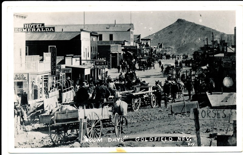
    <summary type="html"><![CDATA[<p><strong><em>Despite the idea that the frontier closed in 1890, popularized by Fredrick Jackson Turner, the West was not settled. The days of boom towns and quick fortunes continued into the twentieth century. Goldfield saw its fair share of boom and bust, labor strife, and environmental disaster in the early 20th century. </em></strong></p><img src="https://www.intermountainhistories.org/files/fullsize/a3b0b6b1d1c51cc614290496da4574ab.jpg" alt="Street Scenes SS1c" /><br/><p>Tucked away in the Middle of Central Nevada on a narrow two lane highway located between Nevada’s two largest populated areas, 200 miles north of Las Vegas and 250 miles south of Reno is the remains of a city that once dwarfed both.  If you were to travel to Goldfield today you would be greeted by a small town composed of a collection of turn of the century buildings, one restaurant, and an impressive castle inspired courthouse, but if you blinked you might miss the town all together. From a casual observer’s position many would find it hard to believe that Goldfield in first decade of the twentieth century was the largest city in the state of Nevada and once had a population that exceeded over 20,000. </p><p>Prospectors were drawn to the dry, remote Nevada desert in previous decades in search of silver and many mining towns such as Tonopah dotted the landscape. Goldfield alluded their picks because it did not offer silver ore, but gold ore. Prospectors discovered gold at the base of Colombia Mountain (the large mountain seen in the background of the town picture) in 1903 and quickly people began flooding in to the region. This once nondescript piece of desert transformed into Nevada’s largest city in only four years. By 1904 Goldfield had its own post office, telephone and telegraph lines, and newspapers. </p><p>The town began as a gathering of tents and adobe buildings because those materials were either light or readily available in the desert, but as the boom moved on more and more modern buildings were added including access to electricity. Businesses included, saloons, hotels, photography shops, and social clubs. Unlike earlier gold rushes many came to Goldfield by car. Early cars had high clearances, solid rubber tires, and could be repaired in the field making them well suited to the desert. This also led to clashes between horse drawn stage companies and automobiles as they fought over who could go on which roads. Rail lines also arrived in town to carry both passengers and ore. The Railroads connected Goldfield to the rest of the country as lines headed out to the north, south and west.  Goldfield received water through a combination of local springs from surrounding canyons and local wells dug around the town site. For an added fee to the city you could even have indoor plumbing brought to your home or business. Though, being in a desert and constantly growing meant water supply was always a problem. The water shortage contributed to fires in Goldfield, in 1906 alone there were three hotel fires in the city. </p><p>At its peak the city hosted sporting and entertainment events including dances, baseball leagues and the Gans-Nelson world championship fight that lasted a whopping 42 rounds. But by 1907 the boom had begun to slow and labor struggles began to emerge. The struggles between miners (led by the IWW) and mine owners made national news as President Teddy Roosevelt was manipulated into calling troops into the city to put an end to the unrest. Though the growth of the city had ended 1908 proved to be the most productive year in the city’s history, but the city was already in decline. As the ore deposits depleted the city shrunk rapidly by the end of 1909 the population fell to 5,000 from a peak of 20,000 to 30,000 in 1907. The city also began to fall apart physically. In 1913 heavy rains fell in the nearby mountains and a torrent of water came rushing down a nearby canyon and strait through town, destroying the low lying segments of town. The city committed to rebuilding but in 1923 another disaster, this time a fire destroyed much of the city and this time threw was little to no energy to rebuild, by decades end all but one rail line had ceased service and Goldfield had declined to a small town. Today Goldfield still stands and contrary to popular belief it is not a ghost town. It still has a population of 300 and serves and the county seat of Esmerelda County and continues to offer services including a post office, DMV, and the county courthouse. The Goldfield Hotel still stands, as well as prominent buildings, such as the Nixon Building and Santa Fe Saloon, continually operating since 1905. </p><p><em><strong><a href="https://www.intermountainhistories.org/items/show/31">For more (including 6 images) view the original article</a></strong></em></p>]]></summary>
    <published>2017-03-03T16:41:54+00:00</published>
    <updated>2026-04-17T19:31:58+00:00</updated>
    <link rel="alternate" type="text/html" href="https://www.intermountainhistories.org/items/show/31"/>
    <id>https://www.intermountainhistories.org/items/show/31</id>
    <author>
      <name>Anthony Graham, University of Nevada, Las Vegas</name>
    </author>
  </entry>
  <entry>
    <title type="html"><![CDATA[Alamo Airways ]]></title>
    <summary type="html"><![CDATA[<p><strong><em>Transportation influences how people are able to access undiscovered lands. The railroad allowed for the transformation of the West. However, in 1919, the first commercial airplane took off, which shortened distances and contributed to a more integrated world. Las Vegas joined the aviation community in 1920 when the first airplane landed in Clark County, but business was slow and only for mail at this time.  </em></strong></p><img src="https://www.intermountainhistories.org/files/fullsize/7de5a40bee46cd3848514963a00651d1.jpg" alt="Bonanza Airplane " /><br/><p>Commercial Aviation put Las Vegas on the map. George Crockett opened Alamo Airport in 1942 which created a hub for his airline and allowed for further commercial traffic. This site is significant because it was the original location for present day McCarran International Airport. During the 1940s the government needed an airport to further military training and Crockett agree to lease the land. Due to his dedication and sacrifice the county was able to provide necessary pilot training for World War II and contribute to the atomic testing project.  Howard Hughes bought the facility and renamed the airport McCarran International after Senator Pat McCarran. Senator McCarran played a huge role in the development of aviation and encouraged ethical business practices and competition among the airlines. Today McCarran International Airport is the fifth busiest in the United States and tenth throughout the world.</p><p><em><strong><a href="https://www.intermountainhistories.org/items/show/30">For more (including 4 images) view the original article</a></strong></em></p>]]></summary>
    <published>2017-03-03T16:23:18+00:00</published>
    <updated>2026-04-17T19:31:58+00:00</updated>
    <link rel="alternate" type="text/html" href="https://www.intermountainhistories.org/items/show/30"/>
    <id>https://www.intermountainhistories.org/items/show/30</id>
    <author>
      <name>Jesi Colston, University of Nevada, Las Vegas </name>
    </author>
  </entry>
  <entry>
    <title type="html"><![CDATA[Atomic Liquors ]]></title>
    <summary type="html"><![CDATA[<p><strong><em>Walk into this aptly themed bar in 2016 and you will find something unique for the city of Las Vegas: an authentic part of its history. While it has expanded in recent years, Atomic is one of those rare historical specimens that has managed to survive, and even thrive, in a city that continuously reinvents itself for the changing tides of tourism. The bar has kept the same look, and many of the same relics of its past, down to the classic neon sign that has adorned the building since Joe and Stella Sobchik opened it in the early 1950s. </em></strong></p><img src="https://www.intermountainhistories.org/files/fullsize/0cbc06ed75225977ab5afc469a76d5d7.jpg" alt="Atomic Neon at Night " /><br/><p>It started in 1945 as Virginia’s Café, named after Stella’s mother who acquired the property in an inheritance from a local judge she cared for during his final years of life. Stella ran the restaurant for her mother with her husband Joe, while Virginia managed other endeavors on the property. At this time, federal military-industrial spending helped the Las Vegas economy to boom, along with many cities in the American West during the Cold War. The arrival of the Nevada Test Site (NTS) in 1951 was one aspect of this federal military involvement in the Las Vegas community, which continued from the World War II establishments of Basic Magnesium Inc. and Nellis Airforce Base. </p><p>Public opinion of the NTS was initially marked by worry of the possible side effects of radiation and fallout. The quick acceptance and even excitement over being a part of the nation’s defense grew from active efforts by the Atomic Energy Commission, along with the generally increased anti-Communist sentiment in the United States. Fears were easy to quell through created images of the American West as simultaneously an empty wasteland made for testing, and a beautiful sunny oasis. </p><p>The development of the NTS contributed to a prominent nuclear culture, a form of patriotic pride in the city, from which Atomic Liquors directly grew. While the NTS was dropping its first above ground test-bomb, Joe and Stella grew tired of cooking food and looked towards selling alcohol. Initially in the form of a liquor store in 1952, by 1954 the Sobhiks had established Atomic Liquors as a full-service bar, complete with a rooftop to watch mushroom clouds rise 60-70 miles outside of town while sipping popular “atomic cocktails” that marked the era.</p><p>As above-ground testing ended in 1963, the “atomic hairdos,” “Miss Atomic Bomb Contests,” and “atomic cocktails” that marked the era’s culture fell-out of popularity. Atomic Liquors, however, remained. Consistently a hangout for mobsters, celebrities, and other Fremont Street laborers, the bar continued as a popular neighborhood staple for a few decades. As the Fremont Street District hit harder economic times, it lost out to the popularity of the Strip, and Atomic Liquors became a little-known neighborhood watering-hole most locals and tourists alike had not heard of, or did not want to venture into. When the Sobchiks passed in 2010, the bar went to their son, Ron, who then sold it to a group of investors, reopening it in 2012, fully restored. Today locals and tourists alike can enjoy the nostalgia of a bygone classic Las Vegas era, while also embracing the new craft beers and cocktail menu that compliments the larger revitalization of Downtown Las Vegas. </p><p><em><strong><a href="https://www.intermountainhistories.org/items/show/29">For more (including 9 images) view the original article</a></strong></em></p>]]></summary>
    <published>2017-02-27T17:36:37+00:00</published>
    <updated>2026-04-17T19:31:58+00:00</updated>
    <link rel="alternate" type="text/html" href="https://www.intermountainhistories.org/items/show/29"/>
    <id>https://www.intermountainhistories.org/items/show/29</id>
    <author>
      <name>Billy Marino, University of Nevada, Las Vegas </name>
    </author>
  </entry>
  <entry>
    <title type="html"><![CDATA[Forced Relocation and The Owens Valley: Numu (Paiutes) and Japanese-Americans and Forced Relocations to and from the Owens Valley]]></title>
    <summary type="html"><![CDATA[<p><strong><em>The Japanese-American workers pictured in the featured image are standing, stooping, and kneeling in the shadows of the eastern Sierra Nevada mountains in Owens Valley, California - and their presence on the land highlights colonial and capitalist themes that underpin the history of the valley itself. Their forced removal and internment during World War II to this isolated rural area is not a unique history to the Owens Valley. Nor is it the only local story of removal. </em></strong></p><img src="https://www.intermountainhistories.org/files/fullsize/00219c688b8f7ec61b8ac671978dba96.jpg" alt="Farming by Mt. Williamson" /><br/><p>Adjacent to the Manzanar Relocation Center is the site of a colonial military project in the valley called Fort Independence. The creation of the fort in 1862 focused on quelling violent skirmishes between Numu (Owens Valley Paiute) and ranchers and farmers who invaded Numu homelands and devastated their food resources. The destruction of seed bearing plants, the deforestation of pine nuts for timber, and the Anglo settlements on Numu irrigated lands and agricultural fields created the atmosphere of violence that Civil War California Volunteers then exacerbated. The colonial focus on terminating Numu land rights and removing them from the valley only temporarily kept them from their homeland, they returned months after their removal in 1863 to salvage their property and enter wage-work on farms, ranches, and within the growing mining industry.          </p><p>While the Numu had been removed from the valley in 1863, Japanese-American citizens were forcibly relocated to the valley in 1942. The ethnocentric experiences are similar: confined to a block of land away from their homes, a military presence policing their lives, the use of labor to create a self-sufficient federal reservation, and the incorporation of their labor into U.S. capitalist production. These colonial policies, like Native reservation life throughout the U.S., brought diverse families together to build a community through work and non-work activities. The mixed memories of internees toward their lives in the camp highlight the connection to place created within Manzanars two-year lifespan.          </p><p>Jeanne Wakatsuki Houston, a co-author of the memoir "Farewell to Manzanar," documented her families experiences there. She remembered her brother Woody declare, “If we’re gonna live in this place, we better get to work,” and she described in detail her family plugging the holes of their barracks, and community creations of bathroom dividers for privacy, public parks, gardens, farms, schools, and churches for recreational and spiritual socializing. However, she also contested positive memories taking place under guard towers and beside barbed wire, “you could measure your liberty by how far they’d let you go.” The creation of community at Manzanar focused on labor and non-labor activities, which Jeanne Houston’s quotes embody. </p><p>Other residents such as Nob Kamibayashi remembered, “We met new friends from throughout the camp. To this day I have friends who were in the same class as me;” Victor Muraoka added, “My job was washing dishes, sweeping, mopping, and helping the cooks. I worked there the longest and hated to leave,” and Saburo Sasaki and Chiyeko “Chickie” Hiraoka Matoba respectively stated, “[We went to the co-op] for ice cream and soda pop, a haircut, or buy a new pair of shoes,” and “School was sort of [the] center of my activities; and so was sports. There were a lot of sports.” These memories concern work and non-work practices, and the positive memories of life and community under civil and military rule. The differences between reservation, concentration, and internment camps consist of the actual mobility of people confined in each place. However, a similarity of all three focus on aspects of family creation and communal work, which for Japanese-citizens at Manzanar created community outside of their California, Oregon, and Washington homes. </p><p><em><strong><a href="https://www.intermountainhistories.org/items/show/28">For more (including 11 images) view the original article</a></strong></em></p>]]></summary>
    <published>2017-02-17T19:31:19+00:00</published>
    <updated>2026-04-17T19:31:58+00:00</updated>
    <link rel="alternate" type="text/html" href="https://www.intermountainhistories.org/items/show/28"/>
    <id>https://www.intermountainhistories.org/items/show/28</id>
    <author>
      <name>Lee Hanover, University of Nevada, Las Vegas </name>
    </author>
  </entry>
  <entry>
    <title type="html"><![CDATA[The Las Vegas Courthouse and Post Office]]></title>
    <summary type="html"><![CDATA[<img src="https://www.intermountainhistories.org/files/fullsize/9b949b6fdc4d133edc9c750b25e722aa.jpg" alt="External Facade " /><br/><p>Located at 300 Stewart Ave, the Las Vegas Federal Courthouse and Post Office, opened on November 27th 1933 and remained in constant use until 2005. Prior to President Franklin Roosevelt’s appointment of a Federal Judge in Las Vegas the state had only one full time federal court in the state capitol, Carson City. Instead, judges from adjacent states rotated through Las Vegas hearing federal cases in the absence of a full time jurist. Judge Roger Thomas Foley’s Appointment in 1945 signified a greater projection of federal power into the “Battle Born State” and more specifically into Las Vegas. Locally, the Courthouse served both to give locals access to Federal offices but is also noteworthy due to the overwhelming federal oversight of Nevada’s natural resources and often contentious relations between the Federal Government and local residents. </p><p>The courthouse also played host to two events of national importance. On November 15th 1950 the Kefauver Hearings on Organized Crime convened in Las Vegas. Although this installment of Tennessee Senator Estes Kefauver’s investigation lacked the theatre of previous episodes it provided insight into sports wire operations overseen by Organized Crime thereby underscoring the national nature of the Mob.  The Kefauver Hearings, apart from providing “must see television” spurred congress to pass gambling bans thereby solidifying Las Vegas’ role as the capital of American gambling. Authors Ed Reid and Ovid Demaris estimate in their book The Green Felt Jungle that organized crime invested more than $300 million in gambling operations in Las Vegas by 1962. </p><p>Later, on April 13, 1955 Hank Greenspun, publisher of the Las Vegas Sun, faced an “inciting murder” indictment over his editorials criticizing Senator Joe McCarthy at the height of his power. Prosecutors cited headlines reading “Is Senator McCarthy a Secret Communist” as evidence that the author, Greenspun, sought to incite McCarthy’s assassination. The council for the defense countered with the First Amendment to the United States Constitution, the guarantee of Free Speech, while also citing the ruin McCarthy brought to one hundred and eight State Department employees that he accused of Communist ties without any evidence. This contention thereby proposed that rather than inciting McCarthy’s murder their client was a journalist with the courage to speak truth to unchecked power. In a small victory for decency Greenspun was acquitted on the first ballot. </p><p>The Las Vegas Federal Courthouse and Post Office was recognized by the Federal Registry of Historic Places on February 10, 1983 (#83001108). The building served as a courthouse until 1965 and as a  Post Office until it was purchased, re-purposed and refurbished into the National Museum of Organized Crime and Law Enforcement. Museum visitors trace the evolution of Organized Crime and Law Enforcement from localized phenomenons to national movements while simultaneously exploring criminal influence both in illegal activities and in shaping American pop culture.</p><p><em><strong><a href="https://www.intermountainhistories.org/items/show/27">For more (including 3 images) view the original article</a></strong></em></p>]]></summary>
    <published>2017-02-17T18:57:49+00:00</published>
    <updated>2026-04-17T19:31:58+00:00</updated>
    <link rel="alternate" type="text/html" href="https://www.intermountainhistories.org/items/show/27"/>
    <id>https://www.intermountainhistories.org/items/show/27</id>
    <author>
      <name>James Steele, University of Nevada, Las Vegas </name>
    </author>
  </entry>
  <entry>
    <title type="html"><![CDATA[The Moulin Rouge: A Symbol of Las Vegas&#039; Civil Rights Struggle<br />
]]></title>
    <summary type="html"><![CDATA[<p><strong><em>The Moulin Rouge was the first racially-integrated hotel and casino in Las Vegas. It was located three miles from the Las Vegas Strip in the city’s Westside district. Although the casino was open for only six months, to this day it continues to represent the promise of racial integration in Las Vegas.</em></strong></p><img src="https://www.intermountainhistories.org/files/fullsize/e1f09cbbef1338d8bd5213a747141349.jpg" alt="Facade " /><br/><p>The Moulin Rouge was opened in 1955 amidst a civil rights battle in Las Vegas. The city’s black residents insisted that Las Vegas officials pass a civil rights ordinance which would allow African Americans to dine, gamble, and stay at Strip hotels. The city’s practice of segregation, which began in the 1930s, had earned it the moniker “The Mississippi of the West.”  While Las Vegas hotels and casinos employed black employees in behind-the-scenes jobs, the workers who dealt with the public, like dealers and servers, were all white. The most visible African Americans employed by the hotels were entertainers like Sammy Davis Jr., Nat King Cole, and Ella Fitzgerald. Even though their names appeared on hotel marquees, black performers were not permitted in the front door and were required to stay in boarding houses in city’s Westside, the neighborhood where Las Vegas’s black population was restricted. A group of white investors led by Will Max Schwartz saw the business potential of an integrated hotel and casino in Las Vegas. Former heavyweight boxing champion Joe Louis was recruited to serve as the Moulin Rouge’s spokesman and purported co-owner.</p><p>From its opening night on May 24, 1955, the Moulin Rouge attracted a mixed clientele of black and white patrons. Celebrities such as Ella Fitzgerald, Frank Sinatra, Harry Belafonte, Bob Hope, Dean Martin, Milton Berle, Dorothy Lamour, Judy Garland, and Marlene Dietrich all made their way to the Moulin Rouge during its short period of operation. The reason why the Moulin Rouge was such a magnet for performers was because it was the only hotel where black and white entertainers could socialize with one another in Las Vegas. Strip hotels attempted to ban its headliners from visiting the Moulin Rouge. White performers such as Tallulah Bankhead were issued ultimatums, but most refused to comply.  Black entertainers who graced the Moulin Rouge’s showroom include Lionel Hampton, Dinah Washington, Gregory Hines, and the Platters. The Moulin Rouge also offered employment opportunities for residents of the Westside. Black Las Vegans found employment as dealers, cocktail waitresses, bartenders, security guards, and managers.</p><p>The Moulin Rouge, named after the famed Parisian cabaret, had 110 rooms, a swimming pool, a 60-foot-high neon Eiffel Tower and a neon sign designed by Betty Willis in the googie style emblematic of the 1950s. The most popular attraction at the Moulin Rouge was its marquee number, a colorful African-themed late night show called The Tropi Can Can which featured Las Vegas’s only all-black chorus line. In June 1955, showgirls from the Moulin Rouge even made the cover of Life magazine.</p><p>In November 1955, financial mismanagement forced the Moulin Rouge’s closure.  By December, the hotel had filed for bankruptcy. Although it was only open for six months, the Moulin Rouge offered its guests a brief glimpse of what a racially-integrated Las Vegas resort looked like.</p><p>In 1960, black Las Vegans, inspired by the wave of civil rights activism sweeping across the country, threatened to march on the Las Vegas Strip unless the city took action to end segregation. A march would not only block access to the Strip, but also embarrass the city and damage its tourism industry.  In March 1960, days before the planned march, the still-shuttered Moulin Rouge served as the venue for a meeting which included NAACP branch president Dr. James McMillan, Nevada Governor Grant Sawyer, and the city’s powerful gaming executives. At the meeting, mediated by Las Vegas Sun editor Hank Greenspun, casino bosses agreed to end their discriminatory policies and allow African Americans to patronize their establishments. </p><p>In the decades since the Moulin Rouge’s initial closure, a number of different owners have attempted to re-open it and restore the hotel to its former glory. The building fell victim to an arsonist in 2003. In 2010 city officials declared the hotel’s decorative tower a risk to public safety and had it torn down. Despite its long period of dormancy, the Moulin Rouge remains an enduring symbol of racial integration and Las Vegas’s civil rights struggle. </p><p><em><strong><a href="https://www.intermountainhistories.org/items/show/26">For more (including 6 images) view the original article</a></strong></em></p>]]></summary>
    <published>2017-02-17T18:29:57+00:00</published>
    <updated>2026-04-17T19:31:58+00:00</updated>
    <link rel="alternate" type="text/html" href="https://www.intermountainhistories.org/items/show/26"/>
    <id>https://www.intermountainhistories.org/items/show/26</id>
    <author>
      <name>Alan Mattay, University of Nevada, Las Vegas </name>
    </author>
  </entry>
  <entry>
    <title type="html"><![CDATA[Japanese Internment at Topaz]]></title>
    <summary type="html"><![CDATA[<p><strong><em>The histories told of World War II are often told in tones of patriotism, justice, and progress.  However, popularized narratives often leave out some of the more complicated and messy events of the time. The history of Japanese Internment at Topaz, Utah is one such story.</em></strong></p><img src="https://www.intermountainhistories.org/files/fullsize/70574f207d4f033313c4f992706cf358.jpg" alt="Topaz, Utah. A panorama view of the Central Utah Relocation Center, taken from the water tower" /><br/><p>The broad narratives of American involvement in World War II include often feature the United States as the hero of the Allied powers, men old and young fighting in Pacific and European theaters of war, and the American home-front experiencing an increase in manufacturing, women in the work force, and rations to support the cause of war. America's involvement led to the Axis powers fall and saved the world from Nazis, fascists, villainous Adolf Hitler, and expanding militarized Japanese empire. This simplified plot, however, leaves out much. What great stories have we missed in our past in the name of perpetuating an overwhelmingly positive American narrative? What lessons about humanity have been sacrificed?</p><p>Topaz, Utah is the site of one such lesson. It is here that 11,212 Japanese-Americans were interned over the course of World War II, with a peak population between 8,100 and 8,300. Executive Order 9066 was signed into action by President Franklin D. Roosevelt on February 19, 1942, ten weeks after the Pearl Harbor attack, and was supported by Congress through Public Law 503 and deemed constitutional by the Supreme Court in the context of war. Such actions sanctioned the voluntary evacuation, then the forced removal, of West Coast residents of Japanese ancestry by the U.S. Army to assembly centers and isolated relocation centers—regardless of citizenship. This decision followed a filing of the Munson report, an investigation of Japanese Americans living on the West Coast, on November 7, 1941 which included such conclusions as “[when] interview after interview piled up…the story was all the same. There was no Japanese ‘problem’ on the Coast. There will be no armed uprising of the Japanese.”</p><p>Moving to internment camps required the sacrifice of careers, properties, and constitutionally-protected rights. Those in the camps made efforts to return to some sense of normalcy; children attended school, adults were employed by the War Relocation Authorities inside camps, and some internees were even able to leave the camp for school or work. At Topaz specifically, the headquarters of the Buddhist Church of America was established, the Boy Scout bugle corps met regularly, and baseball leagues developed and grew to occupy two of the forty-two camp blocks. Not to acknowledge the irony of a love for baseball within the camps, a true American sport, in the midst of a whole-scale questioning of American-ness would be a mistake.</p><p>Most historians point to a trifecta of factors allowing the internment of an entire population in “the land of the free”—namely, racial prejudices, wartime hysteria, and ineffective government leadership. Using the sources below, reflect on the federal actions taken against Japanese-Americans. Was internment necessary? How does an event like this can uncover our own human nature? Asking such questions is not simply an attempt to poke holes in treasured American histories, but to more fully understand human experience in American history. The history of Japanese Internment at Topaz and elsewhere invites us to build empathy and understand with past and present human experience.</p><p><em><strong><a href="https://www.intermountainhistories.org/items/show/17">For more (including 8 images) view the original article</a></strong></em></p>]]></summary>
    <published>2017-02-13T18:23:17+00:00</published>
    <updated>2026-04-17T19:31:58+00:00</updated>
    <link rel="alternate" type="text/html" href="https://www.intermountainhistories.org/items/show/17"/>
    <id>https://www.intermountainhistories.org/items/show/17</id>
    <author>
      <name>Carina Whitesides, Brigham Young University </name>
    </author>
  </entry>
  <entry>
    <title type="html"><![CDATA[The Nunnery]]></title>
    <summary type="html"><![CDATA[<img src="https://www.intermountainhistories.org/files/fullsize/7fd8911778918bad54a0a8a8d8942b72.jpg" alt="Lodge interior. St. Anne&#039;s Retreat. " /><br/><p>Known by various names, including Hatch's Camp, Forest Hills, Pine Glenn, St. Anne's Retreat, and the Nunnery, this historic site is about 6 miles up Logan Canyon in the middle of the Cache National Forest. This former summer camp has been listed on top haunted lists of the US. </p><p>The first owners and developers of the land were the Hatch and Odlum families. Boyd and Anne Hatch and Floyd and Hortense Odum not only developed this land together, but also went into business together starting in the 1920’s and soon became millionaires due to their entrepreneurial efforts. In the 1950s the Hatch family donated the property to St. Thomas Aquinas Parish in Logan. which gladly accepted the property on behalf of the Catholic Church and renamed the camp St. Anne's Retreat. It was only after the Catholic church took over the ownership of the Hatch property that rumors began to take hold of the community, filling the communal mind with images of drowning babies and Satanic nuns. Gary Topping, the archivist of the Catholic Diocese of Salt Lake City, is unaware of any actual crime that would taint the site's reputation in the era when the church used the property as a resort and was unable to find any evidence of any incident in the records of St. Thomas Aquinas Parish. A reporter for the Deseret Morning News was also unable to unearth any evidence backing up local legends. This leads many to believe that these horror stories were created from an environment of prejudice against non-LDS religions in Utah. </p><p>In 1995, Jesse Smith Bushman, a BYU graduate student, conducted a study in which he interviewed two Catholic priests in Utah about their experience as a religious minority in the area during the time that the rumors began about St. Anne’s retreat. These are some of the things they had to say about the LDS church and Catholic relations during the 1950s, “The LDS church and its members tended to overlook the other faiths in the state” and “some adults are still very affected by social barriers and may leave for that reason”. This idea of a “us” versus “them” society is shown in a story that one of the priests shared “about a man who had felt somewhat left out for five years and then after joining the LDS church felt quite accepted." These candid accounts suggest how mistrusting rumors could have started about a non-LDS religious institution. </p><p><em><strong><a href="https://www.intermountainhistories.org/items/show/10">For more (including 2 images) view the original article</a></strong></em></p>]]></summary>
    <published>2017-01-11T00:50:06+00:00</published>
    <updated>2026-04-17T19:31:58+00:00</updated>
    <link rel="alternate" type="text/html" href="https://www.intermountainhistories.org/items/show/10"/>
    <id>https://www.intermountainhistories.org/items/show/10</id>
    <author>
      <name>Taylor Dexter, Brigham Young University</name>
    </author>
  </entry>
  <entry>
    <title type="html"><![CDATA[Escape and Death at Topaz]]></title>
    <summary type="html"><![CDATA[<p><strong><em>A general description of the camp of Topaz and the story of attempted escape and death.</em></strong></p><img src="https://www.intermountainhistories.org/files/fullsize/5214fd4fe0ca6f426e3bd8d3097e073a.jpg" alt="Monument at Topaz Camp Site" /><br/><p>Japanese internment reached its long fingers deep into the interior states of the U.S. not sparing the state of Utah.  Utah's contribution to this program came in the form of Topaz.  Located 15 miles from Delta, Utah, Topaz was created by the War Relocation Agency to house up to 9,000 evacuees.  It would, at its peak, reach a total population 8,232 individuals, and, over the course of its life, Topaz would serve as the home for 11,212 individuals.  These first groups of individuals came mostly from the Tanforan race track that had been converted temporarily into an internment camp.  They were moved into the camp beginning on September 11, 1942.  The camp was constructed in blocks with 34 blocks being devoted to residencies and 8 being administrative, including a hospital built on the site .  Overall, Topaz appeared as a well-developed city with schools, libraries, churches, and other features of a normal community .</p><p>The lack of normalcy in this community was encapsulated by a single event in 1943.  An older gentleman, James Wakasa, was killed while allegedly trying to escape from the camp by crawling under the barbed wire fence.  The local newspaper reported the initial story, that Wakasa had been attempting this escape and was warned four times by the guard before he was fatally shot .  However, a later report by the military showed that he had in fact been standing near the fence when he was shot.  Further investigation revealed that many of the military personnel assigned to guard the camp were combat veterans and this particular guard had seen time in the Pacific, perhaps compromising his objective judgment.  The death of Wakasa brought to the forefront the inherent tensions that existed within the camp between the Japanese American evacuees and the Caucasian administration.  Despite efforts made within the leadership of the camp to eliminate this form of distrust, the fact that the war was still going on and Caucasian Americans were distrustful of most Japanese Americans, citizens or not, was one that could not be passed over lightly.</p><p>In a cruel irony of wartime circumstances, Utah became a place not for refugees as it had been for Mormon Pioneers in the nineteenth century, but one for prisoners of war within their own country.</p><p><em><strong><a href="https://www.intermountainhistories.org/items/show/8">For more (including 3 images) view the original article</a></strong></em></p>]]></summary>
    <published>2017-01-10T23:57:31+00:00</published>
    <updated>2026-04-17T19:31:58+00:00</updated>
    <link rel="alternate" type="text/html" href="https://www.intermountainhistories.org/items/show/8"/>
    <id>https://www.intermountainhistories.org/items/show/8</id>
    <author>
      <name>Benjamin Sowards, Brigham Young University</name>
    </author>
  </entry>
</feed>