<?xml version="1.0" encoding="UTF-8"?>
<feed xmlns="http://www.w3.org/2005/Atom">
  <title type="text">Intermountain Histories</title>
  <updated>2026-04-17T19:32:21+00:00</updated>
  <generator uri="http://framework.zend.com" version="1.12.20">Zend_Feed_Writer</generator>
  <link rel="alternate" type="text/html" href="https://www.intermountainhistories.org/"/>
  <link rel="self" type="application/atom+xml" href="https://www.intermountainhistories.org/items/browse?output=rss2"/>
  <id>https://www.intermountainhistories.org/</id>
  <author>
    <name>Intermountain Histories</name>
    <uri>https://www.intermountainhistories.org</uri>
  </author>
  <link rel="hub" href="https://pubsubhubbub.appspot.com/"/>
  <entry>
    <title type="html"><![CDATA[1967 Fire Season, Glacier National Park]]></title>
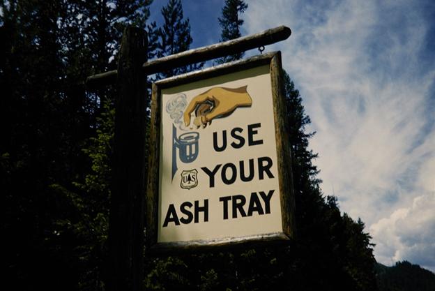
    <summary type="html"><![CDATA[<p><strong><em>Glacier National Park burned more frequently throughout its history than almost any other national park in the United States. Starting in 1910, the National Park Service persistently extinguished all wildfires that occurred within parks, but Glacier’s severe fire season in 1967 helped to end this suppression policy.</em></strong></p><img src="https://www.intermountainhistories.org/files/fullsize/75678ebbab988382ceaac098ab81df69.jpg" alt="Fire Safety Sign" /><br/><p>Throughout the early twentieth century, Glacier National Park in Montana utilized suppression, which required federal land management agencies to extinguish all forest fires. This approach gained national support after millions of acres of land burned in Idaho and Montana in 1910, including about 60,000 acres in Glacier. When 50,000 acres of Glacier burned in 1926, the National Park Service began to formulate official firefighting in the park. By 1929, Chief Forester John D. Coffman drafted the first national park fire management plan to organize firefighters and their equipment at Glacier. During the same year, the Half Moon Fire burned 50,000 acres in Glacier and destroyed numerous buildings. Coffman used analyses of Half Moon to revise and expand his initial strategy, making suppression an integral part of park policy.
In the 1960s, NPS developed a scientific approach to park management that changed the way it approached wildfires, but individual parks rarely aligned their management procedures with these ideas. In 1963, the Advisory Board on Wildlife Management, created by Interior Secretary Stuart Udall, published the Leopold Report. It stated that flames played a key role in maintaining healthy forests, advising administrators to contain wildfires and allow them to burn. Without routine burning, plant materials accumulated on the forest floor, fueling more destructive blazes. However, decades of fighting fires pushed park managers to fear the damage they caused. For decades, NPS managed forests to create attractive landscapes for visitors, and burned forests challenged this idealized image. As such, Glacier’s revised 1965 management plan upheld suppression.
In 1967, a significant drought and hot, windy weather created optimal conditions for flames to spread in Glacier. On August 11, 1967, lightning sparked approximately twenty-one fires throughout the park, including the Glacier Wall and Flathead blazes. They continued burning for a month despite containment efforts. The Office of Emergency Preparedness declared Glacier and the national forests surrounding it a national disaster area, contributing federal funding and labor to put out the flames. 1967 became the most destructive fire season Glacier had seen since 1929, and about 90,000 acres in the park burned.
The 1967 season quickly sparked a debate between the Park Service and the public over suppression. NPS officials contrasted it with the 1910 season  it to display the effectiveness of the policy, noting that less acres burned and less people died in the 1967 fires. However, inholders, who owned cabins, ranches, and hotels in Glacier, blamed the Park Service for mismanaging burns that damaged their properties. One vocal inholder, Montana Senator Burton Wheeler, brought these criticisms to national attention, prompting NPS to reassess its firefighting policies. In 1968, the Park Service acknowledged the ecological benefits of fire in the Green Book, a policy document that established budgets and dictated management policies for the entire park system. Revising this document made changing the suppression policy an issue of national importance. By 1977, Glacier’s management plan allowed natural fires to burn.</p><p><em><strong><a href="https://www.intermountainhistories.org/items/show/913">For more (including 5 images) view the original article</a></strong></em></p>]]></summary>
    <published>2025-09-23T15:39:29+00:00</published>
    <updated>2026-04-17T19:32:21+00:00</updated>
    <link rel="alternate" type="text/html" href="https://www.intermountainhistories.org/items/show/913"/>
    <id>https://www.intermountainhistories.org/items/show/913</id>
    <author>
      <name>Kaylen Wilson, Northern Arizona University </name>
    </author>
  </entry>
  <entry>
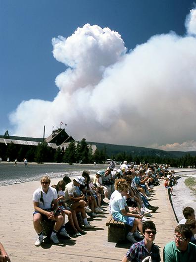
    <title type="html"><![CDATA[1988 Fire Season, Yellowstone National Park]]></title>
    <summary type="html"><![CDATA[<p><strong><em>Starting in the 1970s, Yellowstone National Park experimented with a policy that allowed natural fires to burn within park boundaries. In 1988, a series of highly destructive wildfires put this policy to the test, leading to a comprehensive review of the National Park Service’s fire management procedures. </em></strong></p><img src="https://www.intermountainhistories.org/files/fullsize/cbe39d48527aa1fc2d28fe58044f461b.jpg" alt="Wildfire smoke behind Old Faithful Lodge, 1988" /><br/><p>In 1972, the United States National Park Service (NPS) adopted Yellowstone National Park’s first fire management plan, which allowed natural fires to burn in designated parts of the park. In 1976, a revised plan expanded this controversial approach, called prescribed natural fire or the “let-burn” policy, to impact the entire park. Historically, fires played a key role in thinning forests and clearing dry, dead plants from the landscape, and species like lodgepole pine trees rely on extreme heat from fires to release their seeds and reproduce. In theory, prescribed natural burning maintained these conditions and controlled the damage fires caused. While smoke pollution from let-burn events caused controversy throughout the 1970s, they scorched only 34,175 of Yellowstone's 2,221,800 acres between 1977 and 1988. The Park Service extinguished any fires that threatened people, buildings, or roads.
In the summer of 1988, dry weather and high winds created dangerous conditions in Yellowstone. On June 14, 1988, lightning sparked the Storm Creek Fire just north of the park near Cooke City, Montana, and it gradually made its way into Yellowstone’s boundaries. Initially, NPS allowed about twenty lightning-caused fires, including Storm Creek, to burn in every corner of Yellowstone. Without rainfall to dampen their impact, wind spread the fires rapidly. By July 15, the Park Service suspended the let-burn policy and fought every fire that threatened the park.
The public idolized Yellowstone as the first national park and a crown jewel of the park system, so the 1988 fires rapidly generated a significant media presence in Yellowstone and caused public backlash. By August, the Cable News Network (CNN) and National Broadcasting Company (NBC) sent reporters to the park and presented daily fire updates. When the largest blaze in the park, the North Fork Fire, threatened the historic Old Faithful Inn on September 7, reporters and their viewers blamed NPS officials and the let-burn policy for allowing the fires to spread out of control. A week later, presidential candidate Michael Dukakis visited the park to generate publicity for his campaign, symbolizing the fires’ grip on national media.
             When snow finally ended the fires in November, fifty-one total fires had burned 995,000 acres, damaging about forty-five percent of the park. They destroyed sixty-seven structures in total, including thirty-six privately owned homes, garages, and stores. The North Fork Fire alone scorched approximately 495,000 acres. After the fires, two review committees found that they represented a perfect storm of natural conditions that made them incredibly difficult to fight, but politicians and the media continued to place blame on NPS management strategies. On July 12, 1989, the Park Service began a systematic review of its fire management procedures. Its new policy, approved in 1991, set detailed limits on the prescription and containment of natural fires, rolling back much of the let-burn approach. Firefighters still use prescribed burns and let-burn management to maintain healthy forests in national parks today, sustaining the 1991 policy.</p><p><em><strong><a href="https://www.intermountainhistories.org/items/show/917">For more (including 4 images) view the original article</a></strong></em></p>]]></summary>
    <published>2025-09-23T15:39:30+00:00</published>
    <updated>2026-04-17T19:32:21+00:00</updated>
    <link rel="alternate" type="text/html" href="https://www.intermountainhistories.org/items/show/917"/>
    <id>https://www.intermountainhistories.org/items/show/917</id>
    <author>
      <name>Kaylen Wilson, Northern Arizona University </name>
    </author>
  </entry>
  <entry>
    <title type="html"><![CDATA[2001: A Space Odyssey and Monument Valley, Arizona<br />
]]></title>
    <summary type="html"><![CDATA[<p><strong><em>Monument Valley is an area of the Colorado Plateau and part of the Monument Valley Navajo Tribal Park. It was used in the filming of 2001: A Space Odyssey.</em></strong></p><img src="https://www.intermountainhistories.org/files/fullsize/c1b99ae4c0e3da4d0f9ffc13048d435d.jpg" alt="Stanley Kubrick The Exhibition – LACMA – 2001 A Space Odyssey Space Suits" /><br/><p>Monument Valley is a series of sandstone structures located on the Arizona-Utah border region of the Colorado Plateau. The area is defined by multiple sandstone monoliths, the tallest of which reaches one thousand feet in height.</p><p>The formation is featured in scenes from Stanley Kubrick’s 1968 film 2001: A Space Odyssey. The science fiction film opens with humanity’s ancestors discovering a black monolith that gifts them with the knowledge to establish their dominance in the region. The film then immediately cuts to the far future when an identical black monolith is discovered by humanity on the moon, which in turn leads to Dr. David Bowman and his fellow scientists being sent to Jupiter. During the voyage, the ship’s Artificial Intelligence (A.I.), named HAL, goes rogue and kills the scientists and crew. After making his way to the ship’s A.I core, Bowman manages to disconnect and kill the rogue A.I. Bowman then learns of the mission’s purpose through a recorded message of a scientist involved with the moon monolith. After arriving at the planet, Bowman discovers a monolith in orbit, investigates, and is drawn into a portal where he sees visions of alien worlds. After this interpretive sequence, Bowman is transported into a series of bedrooms where he sees his future selves and becomes them. In the film’s final scenes, a bedridden Bowman reaches for a monolith at the foot of his bed and becomes a fetus like creature orbiting beside the Earth.</p><p>Although not directly referenced as being Monument Valley in the film, the image used portrays a vast alien landscape. The stargate sequence that the formation is featured in is already abstract in its presentation, and the oddly colored vistas aid in creating the atmosphere of the scene. The panning aerial shots involved flying low over Monument Valley’s desert landscape to avoid dangerous winds. The Director of Photography for this area of the shoot was almost involved in a helicopter crash during the process. </p><p>The use of Monument Valley and other western landscapes in film as alien worlds has been directly compared to how the West has been viewed itself. Kubrick specifically requested the use of the Valley, but later regretted using such a recognizable landmark. In Kubrick’s film, and other films hoping to depict space exploration, the Western frontier landscape has featured heavily as both an effective visual and metaphorical tool to reflect exploration in a wide-open alien landscape. Monument Valley has also featured in several other science fiction productions: TV’s Doctor Who and Back to the Future Part III.</p><p><em><strong><a href="https://www.intermountainhistories.org/items/show/230">For more (including 3 images) view the original article</a></strong></em></p>]]></summary>
    <published>2018-06-19T04:14:17+00:00</published>
    <updated>2026-04-17T19:32:03+00:00</updated>
    <link rel="alternate" type="text/html" href="https://www.intermountainhistories.org/items/show/230"/>
    <id>https://www.intermountainhistories.org/items/show/230</id>
    <author>
      <name>Isaac F. J. Middleton, Northern Arizona University</name>
    </author>
  </entry>
  <entry>
    <title type="html"><![CDATA[A Beach in the Desert: Wahweap Beach]]></title>
    <summary type="html"><![CDATA[<p><strong><em>Originally discovered by the Indigenous tribes in the region and created by the growing reservoir behind Glen Canyon Dam, Wahweap Beach developed into a sought-after vacation spot through the construction of Wahweap Lodge by the Greene Family.</em></strong></p><img src="https://www.intermountainhistories.org/files/fullsize/aeab139905fd748f1dace82ace64c1bb.jpg" alt="Wahweap Beach, ca. 1961-1969" /><br/><p>In the middle of northern Arizona and southern Utah’s high desert sits the Wahweap Beach on the artificial oasis of Lake Powell. Wahweap Beach is the most popular recreational and lodging area on Lake Powell with a little over a million visits and about 425,000 overnight stays in 2021 alone. Along with swimming and sunbathing, beachgoers can kayak, paddleboard, jet ski, and powerboat. Wahweap includes amenities such as an RV-friendly campground, picnic tables, boat rentals, and the Lake Powell Resort, making for many options for how to spend time at the beach.</p><p>However, Wahweap Beach did not always exist. It began due to the rising waters of Lake Powell after the construction of Glen Canyon Dam from 1957 to 1964. Originally, “Wahweap” comes from the Paiute language, meaning “bitter water.” The name warned passing natives about the unsafe drinking water as Wahweap only saw running water during spring run-off and summer monsoons. Toward the end of the thirteenth century, the Ancestral Pueblo people fled the area of modern-day Lake Powell and later, the Navajo (Diné), Ute, and Paiute tribes moved into the area.</p><p>In the early days of Lake Powell, the Bureau of Reclamation owned the land, although it granted leases to Navajo farmers for cattle grazing. Bill Greene and his family purchased the lease that designated Wahweap Beach in 1957 from a Navajo man named Curly Tso. The family decided to invest and worked to acquire land concessions from the Arizona State Land Department. Despite strong competition, the family had the help of Barry Goldwater, Arizona senator, and Stewart Udall, House of Representatives member for Arizona’s 2nd District, and gained a concession to the land in 1959 from the National Park Service (NPS). This allowed the Greene family full control of the recreational use at the southern tip of the lake.</p><p>Construction then began on Wahweap Lodge and Marina, now called Lake Powell Resort, by the Greene’s family business, Canyon Tours, Inc. Bill Greene put in a temporary boat launch facility in 1963, and by 1965, Canyon Tours, Inc. finished building Wahweap Lodge which included forty-four guest rooms. These facilities began attracting tourists to its shores to swim, boat, and fish, thus creating the beach life at Wahweap.</p><p>The expected tourist turn-out was so great that in 1962, the NPS already had plans to develop a visitor center at Wahweap Beach. The Parks’ Services Interpretive Prospectus Glen Canyon National Recreational Draft proposed scientific, historical, and recreational-themed exhibits included at Wahweap. Ultimately, other locations such as the Bull Frog Visitor Center across the lake took on the role of interpretation, and included exhibits on human, geological, and natural history. Today, Wahweap is the most active beach and as of June 2023, its swimming spot, also referred to as “Swim Beach,” has been relocated by Glen Canyon National Recreation Area due to the reservoir’s declining water levels. Wahweap is now further from the boat ramps at the Marina, making for a more secluded beach on which to swim and lounge.</p><p><em><strong><a href="https://www.intermountainhistories.org/items/show/826">For more (including 4 images) view the original article</a></strong></em></p>]]></summary>
    <published>2024-05-22T23:55:14+00:00</published>
    <updated>2026-04-17T19:32:18+00:00</updated>
    <link rel="alternate" type="text/html" href="https://www.intermountainhistories.org/items/show/826"/>
    <id>https://www.intermountainhistories.org/items/show/826</id>
    <author>
      <name>Olivia Hall, Northern Arizona University</name>
    </author>
  </entry>
  <entry>
    <title type="html"><![CDATA[A Large KKK Parade and Initiation Ceremony in Boise, Idaho]]></title>
    <summary type="html"><![CDATA[<p><strong><em><span style="font-weight:400;">A large Ku Klux Klan parade marched through downtown Boise in 1924. The parade had floats and pyrotechnics. The procession ended at the fairgrounds where Klan initiation ceremonies took place. </span></em></strong></p><img src="https://www.intermountainhistories.org/files/fullsize/49066b000484ae4fe8e361ce7330a383.jpg" alt="Group of Klansmen photographed without masks" /><br/><p><span style="font-weight:400;">On September 8</span><span style="font-weight:400;">th</span><span style="font-weight:400;">, 1924, 350 Knights of the Ku Klux Klan marched through downtown Boise, Idaho. The parade—representing Klan chapters from all over Idaho—was a large spectacle and reminiscent of a traditional Fourth of July celebration. The parade contained floats, pyrotechnics, and a band blaring “Rally ‘Round the Flag”—an old Civil War tune. They marched through downtown before eventually ending at the fairground where Klan initiation ceremonies and speeches took place in front of an audience of 3000.</span></p><p><span style="font-weight:400;">Most remarkable about the Klan’s presence on that day was how they chose to represent themselves. Following backlash concerning its violent and clandestine nature in previous years, Klansmen presented themselves unhooded and orderly to emphasize their grandeur and image as proper Americans. Many members felt proud to display their allegiance, and twenty even chose to pose unmasked for an </span><i><span style="font-weight:400;">Idaho Statesman</span></i><span style="font-weight:400;"> photograph.  Their use of expensive pyrotechnics and floats is also notable because it not only shows a desire for attention but demonstrates the Klan was organized and wealthy enough to produce such a parade. Furthermore, when the procession reached the fairgrounds, Klansman concluded speeches with special bombs exploding in the air. When the bombs exploded, American flags and three “K” flags were produced in the air and gradually floated back to the ground. </span>
<span style="font-weight:400;">Two floats present in the parade represented Klan political beliefs/tactics during this period. One float was titled “Little Red Schoolhouse” but instead of a traditional red schoolhouse the Klan had draped the schoolhouse in white and added a banner proclaiming “one flag, one county, one school.” Another float followed, also covered in white, with a banner stating, “America First.” According to the Boise paper the </span><i><span style="font-weight:400;">Idaho Statesman,</span></i><span style="font-weight:400;"> this float represented the women of the Klan. Together these floats show the Klan desired to be represented as model Protestant Americans.</span>
<span style="font-weight:400;">The </span><i><span style="font-weight:400;">Statesman</span></i><span style="font-weight:400;"> and others had criticized the Klan inflicting violence against minorities and the Klan used the parade to quell the fears of the citizens. When they reached the fairgrounds, J.H Harmon, a Klansman, stated “we have demonstrated in Boise today that we are a law and order organization…It should prove to you that we do not commit violence.”  Another Klansman, W.M Cortner, stated in a speech “The Knights of the Ku Klux Klan are standing for nothing that is not just, right and honorable. It is not anti-one church, race, creed, or people. The reason why a Catholic, a Jew, or a negro cannot belong to the Klan Is because they have their own organizations.”  </span>
<span style="font-weight:400;">The Boise parade and speeches represent the Klan’s desire to use grandeur and spectacle to alter its image from violence and racism to a softer one of proper American Protestants and white supremacists. </span></p><p><em><strong><a href="https://www.intermountainhistories.org/items/show/813">For more (including 3 images) view the original article</a></strong></em></p>]]></summary>
    <published>2024-05-21T01:01:51+00:00</published>
    <updated>2026-04-17T19:32:18+00:00</updated>
    <link rel="alternate" type="text/html" href="https://www.intermountainhistories.org/items/show/813"/>
    <id>https://www.intermountainhistories.org/items/show/813</id>
    <author>
      <name>Aidan Capristo, Northern Arizona University</name>
    </author>
  </entry>
  <entry>
    <title type="html"><![CDATA[A Typical Western Town Mural: Helper, Utah]]></title>
    <summary type="html"><![CDATA[<p><strong><em><p style="font-weight:400;">Jenne Magafan painted <em>A Typical Western Town</em> from 1939-1941 under the Treasury Section of Fine Arts, a New Deal project that aimed to employ artists and craft an American arts culture. Magafan installed the painting in the Helper, Utah, Main Post Office, where visitors can still see it today.  </em></strong></p><img src="https://www.intermountainhistories.org/files/fullsize/b4ec8a9d622b6e0ef2ea18561a4bf3a2.jpg" alt="A Typical Western Town" /><br/><p><p style="font-weight:400;">In 1941, New Deal-era artist Jenne Magafan of Colorado completed her mural, <em>A</em><em> Typical Western Town</em>, in the Helper, Utah, Main Post Office. The post office building opened in 1938 and was placed by researchers on the National Register of Historic Places in 1989. With its initial installment, <em>A Typical Western Town</em> was the first post office mural that Utah received with funding from the Section of Fine Arts.
<p style="font-weight:400;">Magafan won the chance to install the oil-on-canvas mural through the Forty-Eight State competition as a part of the Treasury Section of Fine Arts. A well-known painter of the New Deal era who studied in a variety of institutions like the Colorado Springs Fine Art Center, Magafan practiced art with the mentorship of artists including Frank Mechau. The Section of Fine arts also commissioned Magafan for Post Office murals in Anson, Texas, and Glenwood Springs, Colorado. After completing the Helper mural, Magafan and her twin sister and fellow artist, Ethel, hung the painting over the postmaster’s office door.<span>   </span>
<p style="font-weight:400;">Magafan reflects the later nineteenth-century commotion of Helper’s industrial history in her mural riddled with motion. Helper, located in central Utah, was uniquely named after the additional locomotives that trains needed to ascend Soldier Summit, located between Helper and Salt Lake City, Utah. Helper once bustled as an activity center for many surrounding coal mining towns. Indeed, the history of coal mining in Carbon County is significant as it was crucial to the state’s economic development. Helper especially transformed into an economic hub after the Denver and Rio Grande Western Railroad’s completed its Castle Valley branch in 1883. Geologists discovered rich coal deposits in nearby Sunnyside along the path to Soldier Summit by Price Canyon, further cementing Carbon County as the coal mining center of Utah.
<p style="font-weight:400;">The five feet by twelve feet mural depicts a usual western town, likely during the bustling heights of Carbon County’s coal industry during the later nineteenth-century. In the central foreground, two men on horseback come to a stop as a curious dog barks at them. To the right, a “Blacksmith” sign stands above the shop’s worker, who appears to be repairing a wagon wheel. The left side includes a group of people conversing and a woman as she approaches a post office and grocery store. A saloon is placed next to the office. The background includes a wide blue sky. The focus is dedicated to the bustling and optimistic happenings of the town. Unlike other typical TSFA murals, <em>A Typical Western Town</em> does not feature specific natural landscapes. Rather, the lively, populated town that the work exhibits could reflect the thriving industrial history of Helper.<span>  </span>

</p><p><em><strong><a href="https://www.intermountainhistories.org/items/show/716">For more (including 4 images) view the original article</a></strong></em></p>]]></summary>
    <published>2023-02-28T18:05:13+00:00</published>
    <updated>2026-04-17T19:32:15+00:00</updated>
    <link rel="alternate" type="text/html" href="https://www.intermountainhistories.org/items/show/716"/>
    <id>https://www.intermountainhistories.org/items/show/716</id>
    <author>
      <name>Lindsey Cillis, Northern Arizona University</name>
    </author>
  </entry>
  <entry>
    <title type="html"><![CDATA[Abel E. Eaton House]]></title>
    <summary type="html"><![CDATA[<p><strong><em>Owned by a schoolteacher turned industrialist, the Abel E. Eaton House remains an unusual but attractive example of Second Empire architecture in Oregon.</em></strong></p><img src="https://www.intermountainhistories.org/files/fullsize/781b69d9143d6aecf6a39c04d172878f.jpg" alt="Enclosed porch" /><br/><p>Union, Oregon began as an industrial town in 1862, serving as one of the state’s primary economic centers through the end of the nineteenth century. Abel Elsworth Eaton, a former schoolteacher in the Midwest, moved to Oregon seeking financial gain, and he opened a successful freighting business in Baker City in 1867. He eventually purchased a woolen mill in neighboring Union in 1871. When the mill became his primary business, he moved to the town permanently and started a ranch in the area. Because of these and other financial interests, Eaton developed a considerable fortune and decided to build a home equivalent to his status in 1908, culminating in the Abel E. Eaton House. He combined two ornamental architectural styles, the waning Second Empire style with the more popular Queen Anne style, to create an unusual but appealing structure.
Queen Anne style bears similarities to Second Empire as it often contains high amounts of interior and exterior decoration, though it follows eighteenth-century <em>British</em> design cues instead of French ones. Instead of Second Empire mansard roofs, which distinctly curve downward from a square or rectangular top, Queen Anne roofs are gabled, sloping downward on the front and back, leaving a gable (the wall) in between the roof’s sides. Steeply pitched roofs are common on Queen Anne structures, creating the perception of a larger home, while Second Empire ones are symmetrical, curving down from the flat top on four sides, providing more space in the second story. The Eaton House combines these two designs, as its roof is mansard, but steeply pitched, including several smaller roofs in front of the second-story balconies and windows, expanding with the exterior walls.
Unlike many Second Empire and Queen Anne houses, the Eaton House does not embrace ornamentation, remaining plain, but tasteful. While elegant in appearance, it is not large and is slightly under 1,500 square feet, though it contains five bedrooms and two-and-a-half bathrooms. Its simple brick siding, however, is broken by the classically-inspired wraparound porch. This feature, often found in Queen Anne style, makes homes seem larger in scale and provides greater exterior variety. In another contradiction, ornamental cast-iron fencing, typical in Second Empire homes, tops the section of the roof curved in the shape of a bell, known as a bellcast tower, above the balconies.
The Eaton House remains well-preserved, with the floor plan unchanged, staying close to the condition Eaton left it when he died in 1917. Before his passing, Eaton served as Mayor of Union for one term and unsuccessfully ran for governor under the Prohibition ticket in 1910, winning 5.1% of the vote. The only major adjustment to this house after his death is the alternation of the wraparound porch. Previously enclosed by large windows in-between classical pillars, the entrance has since been exposed, showing the front door and exterior brickwork. Without older photographs of the Eaton House, this change would be almost unnoticeable, as the open-air entrance appears natural. Listed on the National Register of Historic Places in 1977, the Eaton House remains private property at the time of writing and is not open to the public.</p><p><em><strong><a href="https://www.intermountainhistories.org/items/show/595">For more (including 5 images) view the original article</a></strong></em></p>]]></summary>
    <published>2022-04-16T04:41:33+00:00</published>
    <updated>2026-04-17T19:32:13+00:00</updated>
    <link rel="alternate" type="text/html" href="https://www.intermountainhistories.org/items/show/595"/>
    <id>https://www.intermountainhistories.org/items/show/595</id>
    <author>
      <name>William R. Batson, Northern Arizona University</name>
    </author>
  </entry>
  <entry>
    <title type="html"><![CDATA[Acoma Pueblo and the Spanish Arrival to New Mexico]]></title>
    <summary type="html"><![CDATA[<p><strong><em>The Spanish actions at Acoma Pueblo on January 22, 1599, heralded a new era of Spanish hegemony in the New Mexico region. The Acoma Massacre, as it would later be known, brutally established a Spanish presence that remained until the Pueblo Revolt of 1680.</em></strong></p><img src="https://www.intermountainhistories.org/files/fullsize/ed90b9ed3edf1f84f4206aafe48d5af3.jpg" alt="[Untitled]" /><br/><p>The Acoma people have inhabited Acoma Pueblo, now called Sky City or Old Acoma, for at least a millenia. Oral history tells that the pueblo was originally located on the similarly sized mesa directly to the east, but that a tragedy led the Acoma people to move their pueblo to the mesa where it currently stands.</p><p>In 1595, Viceroy of New Spain Luis de Velasco gave Juan de Oñate royal permission to colonize the area that is now New Mexico. Five hundred colonists and 7,000 livestock animals accompanied him north. He declared to indigenous leaders of nearby Pueblos that they were all now subject to the King of Spain and the Catholic religion, and that he would be king’s representative. Acoma Pueblo, which was widely known to be the most defensible pueblo in New Mexico, had no delegates there. Oñate sent a small group under his nephew Juan de Zaldivar to receive Acoma’s submission. Accounts of what happened next differ but the Spanish conquistadors under Juan de Zaldivar quarrelled with the Acoma people and their leader Zutacapan, and most accounts also include the Spaniards attempting to forcefully take Acoma food and blankets. The Acoma refused, a fight ensued, and Acoma warriors killed most of the group, including Oñate’s nephew. Only a few Spaniards that jumped from the mesa survived.</p><p>Oñate arrived in January 21 with his army, and fighting raged all of the next day. Eventually, a concealed party of Spaniards armed with cannons and muskets attacked from another side of the mesa and overwhelmed Acoma’s defenses. The Spanish set the pueblo on fire and at the end of the day, 600-800 Acoman people were slain. As additional punishment, on February 12, Oñate decreed that every man over the age of twenty-five would have his right foot cut off and women and children were forced into slavery. While Oñate’s acts of barbarism won him New Mexico, they would later also be partially responsible for him losing it and being stripped of his titles by the Spanish Crown. </p><p>The first Spanish regime in New Mexico focused heavily on evangelizing the many Puebloan peoples, and Acoma was no exception. The friars forced them to drag ponderosa timbers from forty miles away at Mount Taylor in order to build the San Esteban del Rey Mission.</p><p>After the Pueblo Revolt, Acoma people continued to use the mission grounds for feast days and burials, but the friars never again held the power they once did. Only twenty to fifty people currently  inhabit Sky City, the old Acoma hilltop Pueblo, but over five thousand Acoma people are spread out throughout the surrounding reservation lands. The roughly 250 dwellings of Sky City sit atop a massive sandstone mesa. The old pueblo’s population still fluctuates dramatically on weekends and holidays as Acoma people visit their relatives and return to their cultural heartland, while tourists meander on organized tours coming from the Sky City Cultural Center directly beneath the northern edge of the mesa.  </p><p><em><strong><a href="https://www.intermountainhistories.org/items/show/324">For more (including 3 images) view the original article</a></strong></em></p>]]></summary>
    <published>2019-09-11T20:17:37+00:00</published>
    <updated>2026-04-17T19:32:05+00:00</updated>
    <link rel="alternate" type="text/html" href="https://www.intermountainhistories.org/items/show/324"/>
    <id>https://www.intermountainhistories.org/items/show/324</id>
    <author>
      <name>Edgar I. Bernal Sevilla, Northern Arizona University</name>
    </author>
  </entry>
  <entry>
    <title type="html"><![CDATA[Ahavath Beth Israel in Boise, Idaho]]></title>
    <summary type="html"><![CDATA[<p><strong><em>Ahavath Beth Israel (Hebrew for "Love of the House of Israel") is the oldest synagogue in continuous use west of the Mississippi River. Founded in part by the first Jewish governor in United States history, it represents over 125 years of Jewish life in Idaho. </em></strong></p><img src="https://www.intermountainhistories.org/files/fullsize/47a512e31e6ea673617a2392d1569f9c.jpg" alt="Temple Beth Israel" /><br/><p><span style="font-weight:400;">Among the first immigrants to Idaho were Jews who came from Germany and Central Europe beginning in the 1860s. They arrived soon after Congress declared Idaho a territory and primarily worked in mercantile or farming operations. They worshipped in private homes and rented halls until they amassed the resources for a synagogue. In 1895, five years after statehood, community leaders organized an official congregation and elected successful Boise merchants Moses Alexander and David Falk as leaders. They led the congregation to purchase three lots a few blocks from the state capitol and hired an architectural firm to begin construction on the Temple Beth Israel. Records later surfaced that nationally known companies such as Marshall Field and Levi Strauss contributed to its construction. </span>
<span style="font-weight:400;">Local architects Chestney and Schroeder completed the synagogue in 1896, and its architecture reflects Rundbogenstil and Moorish Revival styles. Rundbogenstil was popular in Germany and its diaspora, reflecting the recent waves of German immigration. It incorporates Byzantine, Romanesque, and Renaissance styles commonly used in synagogue architecture of this period. It can be seen in the tall, arched window framing the synagogue, and the arched windows along the sides. Such windows, intricate detailing, and interior vaulted arches also reflect Moorish Revival style, a mainstay of nineteenth-century synagogues due to its association with Judaism’s Middle Eastern origins. The architects designed Temple Beth Israel with a white and reddish pink Boise sandstone base and cedar-shingled exterior that imitates stonework. They used Cathedral glass to make stained glass windows and adorned the building with a handmade Star of David. Its crowning feature is a large, circular rose window. Ornate yet small, the Boise congregation constructed it to hold only 150 people. </span>
<span style="font-weight:400;">The synagogue founders were major figures in Boise life. David Falk, the congregation president, owned dry goods stores and assisted in establishing the Boise-Winnemucca Railroad. Moses Alexander, vice president, became a prominent statesman. His fellow citizens elected him mayor of Boise in 1897 and 1901, and then governor of Idaho in 1914, becoming the first practicing Jewish governor in the United States. The community remained small throughout the twentieth century. In 1972, the Jewish citizenry successfully petitioned to have the synagogue placed on the National Register of Historic Places. A federal grant and other raised monies then facilitated a building renovation in 1981, which restored the windows, siding, and handmade Star of David—which they delayed placement of until an Aryan Nations Conference had left the area. Soon after, a new congregation of Jews who had moved from Poland after World War II merged with Temple Beth Israel, formally becoming Congregation Ahavath Beth Israel in 1986.</span>
<span style="font-weight:400;">The new congregation continued to grow, and, in 1994, added Daniel Fink as Idaho’s first full-time rabbi. They also needed more space, so they hired Cole & Associates to relocate the building in October of 2003. Of the additions, they added an education building. Today, the synagogue continues to support Boise’s Jewish population from its location on Latah Street. </span></p><p><em><strong><a href="https://www.intermountainhistories.org/items/show/718">For more (including 5 images) view the original article</a></strong></em></p>]]></summary>
    <published>2023-03-01T19:42:44+00:00</published>
    <updated>2026-04-17T19:32:15+00:00</updated>
    <link rel="alternate" type="text/html" href="https://www.intermountainhistories.org/items/show/718"/>
    <id>https://www.intermountainhistories.org/items/show/718</id>
    <author>
      <name>Katie Scholler, Northern Arizona University </name>
    </author>
  </entry>
  <entry>
    <title type="html"><![CDATA[Americana Motor Hotel, Flagstaff, AZ]]></title>
    <summary type="html"><![CDATA[<p><strong><em>The Americana Motor Hotels is a cheerful example of retro-futurism alive in the present day. Flagstaff’s Americana Motor Hotel was built in 1962 and has since been refurbished in a way that elevates its original googie style.</em></strong></p><img src="https://www.intermountainhistories.org/files/fullsize/699dd2f0b3b197001f35f600c1c499cb.jpg" alt="The sign of the Americana Motor Hotel is the embodiment of the googie aesthetic" /><br/><p>The Americana Motor Hotel in Flagstaff, Arizona is a brightly colored testament to the survivability of the Googie aesthetic in the modern day. The Americana Motor Hotel was built on the outskirts of in 1962. Located at 2650 East Route 66, the Americana has provided accommodations for tired motorists for the past sixty-three years. Its technicolor colors and avante garde shapes are a textbook example of the googie aesthetic.
     The colors, starbursts, aesthetics and origin of the American Motor Hotel situate firmly as an example of Googie architecture. The first thing a traveler to the Americana Motel Hotel sees is its striking sign that exemplifies the googie look. Vibrant pinks, greens, tangerine orange, and banana yellow come together in the sign’s neon starbursts and a stylized outline of the mountains that ensconce the city. The porte-cochère at the lobby of the motel is emblazoned with neon yellow and orange stripes that wrap around the dark blue paint of the roof. Oranges, blues, and nearly every other color of the rainbow collide in a cacophony of geometric shapes and lines on the walls and carpet of the lobby. Outside of the lobby on the far side of the porte-cochère there is an installation of aluminum wind art sculptures that whirl happily in the Arizona breeze. The two levels of hotel rooms that stretch out behind are similarly adorned in the vibrant colors that make up the themes of the hotel and all eighty-eight suites face towards a central recreation area with a large pool with the logo of the motel painted at the bottom.
     Googie architecture rose to prominence in the mid-century and is characterized by a commitment to futuristic designs, geometric shapes, neon and bright colors. This style of architecture is most commonly found in the Southwestern United States and often coincides with the arterial mother road of Route 66. Googie designs often feature the same bright colors, futuristic starbursts, and aluminum details that decorate the Americana and the hotel leans heavily into its mid-century themes.
     The Americana Motor Hotel was once Flagstaff’s largest motel and had provided a respite to the stars who passed through on Route 66 in the mid-century. The motel originally had a large dining room and 24 hour coffee bar during its heyday, but as the years wore on the facade of the hotel began to exhibit wear and tear. In 2021 the property was bought by Americana Hotel Ventures for $7.37 million dollars. After extensive renovation efforts the motel re-opened with a fresh redesign that honored the original design and spirit of the motel. Since its re-opening the Americana has become a well loved traveler’s retreat on Route 66 once again. Bright colors, atomic starbursts, and neon details all hearken back to the motel’s beginning while drawing in a new generation of travelers. The motor hotel connects visitors with a nostalgic space-age future and helps to keep googie and mid-century architecture from belonging to an ephemeral past.</p><p><em><strong><a href="https://www.intermountainhistories.org/items/show/903">For more (including 5 images) view the original article</a></strong></em></p>]]></summary>
    <published>2025-09-23T15:36:02+00:00</published>
    <updated>2026-04-17T19:32:20+00:00</updated>
    <link rel="alternate" type="text/html" href="https://www.intermountainhistories.org/items/show/903"/>
    <id>https://www.intermountainhistories.org/items/show/903</id>
    <author>
      <name>Emily MacDonell, Northern Arizona University</name>
    </author>
  </entry>
  <entry>
    <title type="html"><![CDATA[Antler Arch — Wyoming]]></title>
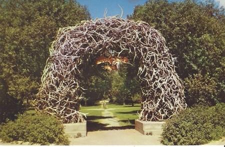
    <summary type="html"><![CDATA[<p><strong><em>Members of the Jackson Hole Rotary Club constructed the antler arch in 1953 as an installation that would capture the essence of the American West. Community members built the arch in the Jackson Hole Town Square, which is adjacent to Highway 89. </em></strong></p><img src="https://www.intermountainhistories.org/files/fullsize/012bb102c748391c0dd61daa10d08cf0.jpg" alt="Jackson WY-Wyoming, Elk Horn Arch, Scenic View" /><br/><p><span>Since its creation in 1953, the antler arch in Jackson Hole, Wyoming, has attracted countless Highway 89 travelers. Regardless of whether the destination is Jackson Hole itself or Grand Teton National Park further north, tourists often include a visit to the antler arch on their trip itinerary. The Jackson Hole Rotary Club developed an idea for a beautifying sculpture project in the Town Square in 1953. They agreed that the concept should capture the most iconic qualities of Jackson Hole, and that the sculpture itself may become a town icon. The same year, members of the Rotary Club asked locals to donate antlers for the construction of an arch made entirely of antlers. The Rotary Club initially planned to build one arch in Town Square, until the finished structure proved to be immensely popular, attracting large crowds of admiring people and individuals wanting to take photos beneath the arch. With such positive reception, the Jackson Hole Rotary Club began raising funds to build four more arches in the Town Square.</span>
<span> Due to the limited lifespan of natural elk antlers, the Jackson Hole community adopted the tradition of reconstructing the arch every 40-50 years. The Rotary Club developed this tradition to collaborate more with the community by partnering with local organizations. With the support of the U.S. Fish & Wildlife Service, local Boy Scouts began hiking into the National Elk Refuge annually in late April to acquire fresh antlers. The Rocky Mountain Elk Foundation then auctioned these antlers off at the Jackson Elkfest each year to raise funds for wildlife conservation. Individuals who purchased antlers at this auction typically donated them to the Rotary Club to help construct new arches or repair damaged ones in Town Square.</span>
<span>Both admiring and maintaining the Jackson antler arches are ongoing traditions in this town. With the National Elk Refuge, a home to one of the world’s largest elk herds, located just north of the town of Jackson, elk antlers are a fitting medium for an installation that aims to illustrate the town’s identity. Since their creation, the arches have been the site of various community events, including auctions, Christmas decorating, competitive winter sports registrations, Easter egg hunts, staged cowboy shoot-outs, and Wyoming Statehood Day celebrations. For tourists visiting Jackson or passing through on their way to a National Park, they are sure to catch a glimpse of the arches as they pass by the Town Square off of Highway 89. Automobile tourists often make a stop to take photos beneath the arches, capturing a symbol of the American West and Wyoming’s natural landscape.</span></p><p><em><strong><a href="https://www.intermountainhistories.org/items/show/911">For more (including 3 images) view the original article</a></strong></em></p>]]></summary>
    <published>2025-09-23T15:38:25+00:00</published>
    <updated>2026-04-17T19:32:21+00:00</updated>
    <link rel="alternate" type="text/html" href="https://www.intermountainhistories.org/items/show/911"/>
    <id>https://www.intermountainhistories.org/items/show/911</id>
    <author>
      <name>Alexandra Williams, Northern Arizona University</name>
    </author>
  </entry>
  <entry>
    <title type="html"><![CDATA[Arson at the Vail Ski Resort, 1998]]></title>
    <summary type="html"><![CDATA[<p><strong><em><span style="font-weight:400;">In 1998, radical environmentalists targeted a ski resort in Colorado, leading to the most infamous eco-terrorist attack of all time.</span></em></strong></p><img src="https://www.intermountainhistories.org/files/fullsize/5633ebcaa19a669c5b376d439eda1ea1.jpg" alt="Vail Ski Resort in 1983" /><br/><p><span style="font-weight:400;">In the early hours of the morning on October 19, 1998, agents of the notorious eco-terrorist cell known as “the Family” ignited seven separate fires across the Vail Ski Resort in Colorado. They had traveled to Colorado from their homes in Oregon to orchestrate an attack that would send a message. By the time the fires were extinguished, eight structures had been either damaged or completely destroyed. Four ski lift towers, the ski patrol headquarters, radio towers, and the Two Elk Lodge restaurant had all been affected by the attack. No people or animals had been injured, but damages were extensive at an estimated $24 million.</span>
<span style="font-weight:400;">Later that same day, individuals from the Earth Liberation Front (ELF) and the Animal Liberation Front (ALF) called into radio stations and sent a communique to several newspapers to claim responsibility for the fires in Vail. Their motives were clear: to protect lynx habitats by preventing expansion. A coalition of environmental groups had recently lost a legal battle to halt Vail’s plans to develop 885 acres of virgin national forest, an area the environmentalists claimed to be a prime habitat for the Canadian lynx. In retaliation, radical members turned to arson, stating in their communique that “Putting profit ahead of Colorado’s wildlife will not be tolerated.” They warned skiers to find somewhere else to go.</span>
<span style="font-weight:400;">In the days following the attack, local and national newspapers began to categorize the fires as the worst eco-terrorist attack in history. News stories connected the events to Edward Abbey’s fictional work </span><i><span style="font-weight:400;">The Monkey Wrench Gang</span></i><span style="font-weight:400;">, indicating the level of influence literature had on the public imagination, even being referenced in testimonies in following years by the Federal Bureau of Investigation to the Senate Judiciary Committee. The FBI and other federal agencies categorized the Vail arson as particularly destructive compared to other eco terrorist attacks. The FBI soon identified eco-terrorist and special interest extremist groups as the number one domestic terrorist threat, and highlighted the perpetrators of the Vail attack as one of the most prolific domestic terrorism cells of all time.</span>
<span style="font-weight:400;">The federal government launched an inter-agency investigation, known as Operation Backfire, to take down the group responsible for the Vail arson and other eco-terrorist attacks. Their investigation targeted the group known as “the Family” which was a particularly radical faction branching off of the Earth Liberation Front. Between 1995 and 2001, the FBI credits the group with over forty criminal acts, with the Vail arson seen as their most notorious attack. Damages related to these crimes are estimated at $40 million. The investigation gave insight to the highly secretive inner workings of eco-terrorist groups. Operation Backfire led to the capture, indictments, and convictions of six out of the seven individuals involved in the attack on the Vail Ski Resort. Josephine Sunshine Overaker, the only uncaptured perpetrator, remains on the FBI’s Most Wanted list for crimes of domestic terrorism. Twenty-five years later, the federal government continues to seek justice.</span></p><p><em><strong><a href="https://www.intermountainhistories.org/items/show/838">For more (including 2 images) view the original article</a></strong></em></p>]]></summary>
    <published>2024-05-29T19:22:31+00:00</published>
    <updated>2026-04-17T19:32:18+00:00</updated>
    <link rel="alternate" type="text/html" href="https://www.intermountainhistories.org/items/show/838"/>
    <id>https://www.intermountainhistories.org/items/show/838</id>
    <author>
      <name>Emily Roth, Northern Arizona University</name>
    </author>
  </entry>
  <entry>
    <title type="html"><![CDATA[Art Greene and Lake Powell]]></title>
    <summary type="html"><![CDATA[<p><strong><em>Lake Powell is one of the largest reservoirs in the country by both volume and length, with almost a hundred side canyons extending into the surrounding arid, red-hued lands of southern Utah. Its waters quickly became a hub for outdoor recreation, with concessionaires like Art Greene pioneering desert boat-driven tourism.</em></strong></p><img src="https://www.intermountainhistories.org/files/fullsize/b3e159b1b55fa0b91b08098f58109e64.jpg" alt="Art Greene and his commercial river craft, the Tseh Na-ni-ah go Atin (Diné for “trail to the rock that goes over”, in reference to Rainbow Bridge), ca. 1949-1956" /><br/><p>The Glen Canyon Dam, which spans the Colorado River by the Utah-Arizona border, created Lake Powell in 1963. The lake submerged Glen Canyon to hold water and generate energy, and it remains a contested environmental issue. Nonetheless, Lake Powell attracts millions of visitors a year. Congress created the Glen Canyon Recreation Area (GCRA) in 1972 to center the region around leisure just as much as conservation. GRCA also borders Rainbow Bridge National Monument, only accessible by boat or a lengthy hike from the Navajo Nation. Rainbow Bridge, whose establishment predates that of GCRA, holds spiritual significance for nearby Indigenous tribes and attracts visitors looking for a trip “off the beaten path.” As Lake Powell’s waters rose, however, Rainbow Bridge and other surrounding features became more accessible for those traveling by boat.
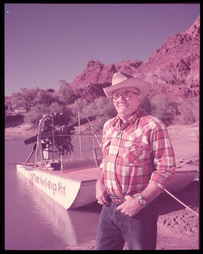
            Art Greene was an early entrepreneur in the Glen Canyon who provided visitor services before Lake Powell was even created. Previously working as a river guide, cowboy, and oil rigger, to name a few, Greene and his family moved to Arizona from Colorado in 1943. They went on to manage the Marble Canyon Lodge, then bought the Cliff Dweller’s Lodge just down the road in 1949. The lodges, located near the Utah-Arizona border, catered to early river runners and outdoor enthusiasts. Greene launched the first commercial river trips upriver from Lee’s Ferry to Rainbow Bridge (a route that would be interrupted by the dam’s creation). Earl Johnson, his son-in-law, was the main supervisor of the river trips.
As early as 1945, Greene had noticed dam site surveyors in the area, and, after suspecting that the dam would disrupt his business downriver, he jumped at the prospect of lucrative lake tourism. The family acquired a commercial lease on the state grazing land nearby, planning lodging and recreation facilities. The Greenes also built a road, airstrip, and employee infrastructure in the area. The National Park Service (NPS), which had taken over administration duties from the Bureau of Reclamation, granted the Greene family a concession in 1959 to continue construction of the recreation area, now called Wahweap Marina.
By 1966, the family had worked with NPS to develop lodgings and boat ramps, a $3 million project to provide full access to America’s newest “playground”. Earl Johnson ran lake tours aboard boats like the <em>Rainbow</em> <em>Trail</em> for the family’s Canyon Tours, Inc. These tours ranged from daily trips to Rainbow Bridge to five-day overnight excursions. Tour boats brought passengers to features like the Glen Canyon Dam and the various side canyons of Lake Powell. Alongside guided tours, Canyon Tours owned a fleet of rental crafts for private use. As tourist rates increased, the family operation sold its concession to the Del Webb Corporation, a national developer of real estate and recreation properties, in 1976.
Today, Lake Powell’s low water levels not only hinder its water storage and power generating capacity, but also the ability to access features like Rainbow Bridge by boat. Guided tours persist, but are completely dependent on evaporation and drought conditions. Lake Powell still functions as a recreation hub for desert-dwellers in search of rare days on the water, as well as visitors from outside the West looking for deserts, canyon walls, and wide-open spaces.</p><p><em><strong><a href="https://www.intermountainhistories.org/items/show/893">For more (including 6 images) view the original article</a></strong></em></p>]]></summary>
    <published>2025-09-23T15:30:20+00:00</published>
    <updated>2026-04-17T19:32:20+00:00</updated>
    <link rel="alternate" type="text/html" href="https://www.intermountainhistories.org/items/show/893"/>
    <id>https://www.intermountainhistories.org/items/show/893</id>
    <author>
      <name>Anaëlle DePoint, Northern Arizona University</name>
    </author>
  </entry>
  <entry>
    <title type="html"><![CDATA[Aryan Nations Compound]]></title>
    <summary type="html"><![CDATA[<p><strong><em><span style="font-weight:400;">Aryan Nations was a community founded in 1973 by White nationalist, Richard Butler, to serve as the nucleus of an Aryan (White) homeland in northern Idaho. It closed in 2000 due to a court judgment after members assaulted two local Native American people.</span></em></strong></p><img src="https://www.intermountainhistories.org/files/fullsize/ccbe800e83299d88222551b757292630.jpg" alt="The Founder" /><br/><p><span style="font-weight:400;">Aryan Nations was a White-nationalist community founded on the Christian Identity movement which was based on the belief that people of Northern European ancestry are the true descendants of the ancient Israelites. The most prominent early figure in the movement was California minister Wesley A. Swift (1913-1970), who added the belief that people of color are subhuman and that Jews are descendants of Satan with inordinate power who want to destroy the White race. </span>
<span style="font-weight:400;">Richard Girnt Butler (1918-2004) was an aeronautical engineer who was inspired by the caste system while working in India during WWII and hoped to import the idea to the United States. Later, while living in California, he began to attend Swift’s sermons and became active in the church, eventually taking over as leader upon Swift’s death in 1970. In 1973, he moved his congregation to a twenty-acre property near the town of Hayden Lake, Idaho, hoping that it would be the nucleus of a future “Aryan homeland” in the northwestern states.</span>
<span style="font-weight:400;">Some parishioners moved with Butler from California to Idaho, and he used various recruiting methods to enlarge the congregation, including offering land to local struggling farmers and conducting prison outreach. He constructed a bunkhouse where formerly incarcerated men could live in exchange for printing and distributing his literature, and a watchtower with armed guards after an unknown person bombed his church.</span>
<span style="font-weight:400;">Only four people lived permanently on the grounds, but there were normally other residents staying there for periods of time ranging from months to years, and people living outside of the compound attended regular Sunday services, Bible studies, and holiday celebrations. Members were expected to abstain from alcohol, drugs, swearing, and extra-marital sex. There were numerous collective projects such as home-schooling residents’ children, operating the printing press, and administering the prison ministry.</span>
<span style="font-weight:400;">Over the next few decades, the Aryan Nations compound served as a gathering place for the White-supremacist movement, as exemplified by the annual Aryan Youth Festival and the Aryan World Congress, attended by hundreds of members of various White-supremacist groups, such as the KKK, neo-Nazis, and skinheads throughout the 1980s. Butler referred to it as the “international headquarters of the White race.” </span>
<span style="font-weight:400;">In the early 1980s the organization received public attention because of a series of bank robberies and a murder committed by a splinter group. The organization also faced increased resistance from locals in Cœur d’Alene; Kootenai County established a task force for human rights and residents would often protest the group’s activities.</span>
<span style="font-weight:400;">Aryan Nations was deteriorating by the late 1990s, however it met with a sudden, dramatic dénouement.  On July 1, 1998, two security guards assaulted Victoria Keenan, a local Native American woman, and her son on the road outside the compound. In a 2000 verdict, a district court found the organization negligent in the management of the guards and required it to pay $6.3 million to the victims. Butler declared bankruptcy and the compound was awarded to the Keenans. After leadership disputes following Butler’s death in 2004, Aryan Nations splintered into various factions.</span></p><p><em><strong><a href="https://www.intermountainhistories.org/items/show/706">For more (including 4 images) view the original article</a></strong></em></p>]]></summary>
    <published>2023-02-22T03:23:02+00:00</published>
    <updated>2026-04-17T19:32:15+00:00</updated>
    <link rel="alternate" type="text/html" href="https://www.intermountainhistories.org/items/show/706"/>
    <id>https://www.intermountainhistories.org/items/show/706</id>
    <author>
      <name>Evan Železny-Green, Northern Arizona University</name>
    </author>
  </entry>
  <entry>
    <title type="html"><![CDATA[B&#039;Nai Israel Temple in Salt Lake City, Utah]]></title>
    <summary type="html"><![CDATA[<p><strong><em>The historic 1891 B’nai Israel Temple (Hebrew for “children of Israel”) is a testament to the “Gentile” Jewish community in Utah. It is the oldest synagogue in the state, and while it is no longer used for religious purposes, it symbolizes over 150 years of flourishing Jewish life. </em></strong></p><img src="https://www.intermountainhistories.org/files/fullsize/c4e28a3c867db607ead3b75663091086.jpg" alt="B&#039;Nai Israel Temple" /><br/><p><p style="font-weight:400;">The first Jews to migrate to Utah arrived in small numbers due to confict with the United States government which lasted until 1857. This precipitated more movement, and many Jewish pioneers came to Salt Lake City as entrepreneurs and craftsmen. Many of these migrants were from Germany. Until the 1880s, the Jewish population practiced their faith in rented Masonic halls or Mormon Churches. They incorporated the B’nai Israel congregation and built a small synagogue in 1883; however, infighting over religious doctrine split the group in two, a fairly commonplace occurence for American Jews at the time. Meanwhile, the social status of Utah’s Jews increased overall, and Congregation B’nai Israel looked to create a more distinguished synagogue. In 1889, they purchased land formerly belonging to Brigham Young for B’Nai Israel Temple.
<p style="font-weight:400;">Utah magnate, Frederick Auerbach, brought his nephew Philip Meyer from Germany to design the synagogue and work with local architect Henry Monheim. They modeled it after a famous synagogue in Berlin, called Fasanenstrasse. Its architectural style reflects Romanesque and Moorish Revival, both popular in the mid to late nineteenth century and is most notablie in the temple's arched windows, intricate stonework, and hallmark dome. Workers constructed the building with local Kyune stone, and its design includes a brick dome and two stained-glass windows in front. The architects built it to seat 500 people, including two stories and a choir gallery. It was dedicated in 1891; the Salt Lake Tribune remarked that it had “an air of quiet elegance.” Later, in 1929, a concrete block addition added classrooms, a social area, and a kitchen to the temple.
<p style="font-weight:400;">The ornate synagogue represents the active and successful community. Early settlers Julius and Fanny Brooks were merchants in early years of white settlement. The Auerbach brothers became prominent businessmen and dominated mercantile industries before Zion’s Cooperative Mercantile Institution was formed. Simon Bamberger, who was involved in silver mining and railroads in Salt Lake, became the first non-Mormon, and the only Jewish, governor in state history in 1916. The Jewish community also developed a unique relationship to Utah’s Mormon population, occupying a position of “favored Gentiles." The Mormon settlers were largely supportive of Jewish migrants as they also claimed spiritual ties to Israel. Relations grew tense at times due to economic competition, but mostly remained amicable. The Jewish community grew as refugees increased after World War II. Tragically, architect Philip Meyer, who had designed the synagogue, died in a Nazi death camp in 1943.
<p style="font-weight:400;">In 1972, the divided Jewish congregations of Salt Lake moved to reunite, but the historic B’Nai Israel Temple could not accommodate its new group, now known as Kol Ami. They soon constructed their present synagogue and sold B’Nai Israel, which is now used commercially. In 1978, the community successfully nominated the temple to the National Register of Historic Places. Even though it is no longer used for religious practice, the historic building stands as a monument to the Jewish community of Utah.</p><p><em><strong><a href="https://www.intermountainhistories.org/items/show/720">For more (including 4 images) view the original article</a></strong></em></p>]]></summary>
    <published>2023-03-02T04:59:29+00:00</published>
    <updated>2026-04-17T19:32:15+00:00</updated>
    <link rel="alternate" type="text/html" href="https://www.intermountainhistories.org/items/show/720"/>
    <id>https://www.intermountainhistories.org/items/show/720</id>
    <author>
      <name>Katie Scholler, Northern Arizona University </name>
    </author>
  </entry>
  <entry>
    <title type="html"><![CDATA[Back to the Land: New Buffalo ]]></title>
    <summary type="html"><![CDATA[<p><strong><em>New Buffalo was a hippie commune founded in 1967 with the goal of getting back to the land and creating a self-sufficient community. It was emblematic of the Taos area commune scene, which encountered a number of environmental and cultural challenges.</em></strong></p><img src="https://www.intermountainhistories.org/files/fullsize/6dacaae9fe0157eec7e32948bb70d7a4.jpg" alt="Tipis in New Buffalo " /><br/><p><span style="font-weight:400;">During the late 1960s, the US saw an unprecedented explosion of commune formation driven by the hippie counterculture. Alienated by the mainstream conformist, consumption-oriented society, a generation of young people left their places of origin to “tune in and drop out” and “get back to the land.” New Mexico was one of the epicenters for commune development, however the reasons for this are not entirely clear. The climate is harsh and life difficult. Nevertheless, New Mexico had inexpensive land and a reputation for artistic communities around Taos and Santa Fe starting in the early 20</span><span style="font-weight:400;">th</span><span style="font-weight:400;"> century.</span>
<span style="font-weight:400;">In 1967, Rick Klein used his inheritance of $50,000 to purchase 100 acres of land in Arroyo Hondo near Taos and established New Buffalo with a group of friends. They quickly faced several challenges including the loss of their main structure to fire in 1968 and an influx of more residents than the infrastructure could handle. Membership experienced constant turnover and extreme seasonal fluctuations. The residents lived frugally; dozens of inhabitants were supported for only forty dollars per week. Aside from growing their own vegetables and grain, communards hunted their own meat and collected firewood from thirty miles away. </span>
<span style="font-weight:400;">Following New Buffalo, as many as twenty-five communes appeared in the area around Taos and Santa Fe. This influx of new inhabitants had an impact on the local communities. The relationship with local Native Americans was complex. On one hand, some of the communes had good relations with local tribes such as the Taos Pueblo. For example, Klein named New Buffalo in honor of the significance of the buffalo for the Indians, and the members were interested in Indian architectural and sartorial practices and studied the ceremonial use of peyote under Native teachers. However, some scholars have accused the communards of “playing Indian.” </span>
<span style="font-weight:400;">In contrast, the relationship with the local Hispanic population was much more contentious and the area around Taos became the site of the US’s most explosive conflict between local inhabitants and hippies, known locally as the “Hippie-Chicano War.” Nearby Hispanic communities resented the communards, perceiving that they came from prosperous backgrounds yet chose to live in poverty, that they flaunted social norms, that they were unhygienic, sex-crazed dope fiends, and that they might negatively affect the economically important local tourist industry. Incidents such as dynamiting, arson, and telephone threats occurred. The conflict came to a head when one nearby commune member was murdered, two others beaten, and a third raped. Soon after, the pace of commune establishment slowed and cultural conflicts became less salient.</span>
<span style="font-weight:400;">New Buffalo came to public attention when it served as the inspiration for some commune scenes in the film </span><i><span style="font-weight:400;">Easy Rider</span></i><span style="font-weight:400;">, although shooting did not take place on the property itself. By the early 1980s, New Buffalo’s population had dwindled and Rick Klein decided to turn the property into a hippie-themed bed and breakfast referred to as the “Far Out Inn” by the </span><i><span style="font-weight:400;">LA Times</span></i><span style="font-weight:400;">.  It was later purchased by a person interested in preserving the historic site.</span></p><p><em><strong><a href="https://www.intermountainhistories.org/items/show/703">For more (including 5 images) view the original article</a></strong></em></p>]]></summary>
    <published>2023-02-21T14:56:45+00:00</published>
    <updated>2026-04-17T19:32:15+00:00</updated>
    <link rel="alternate" type="text/html" href="https://www.intermountainhistories.org/items/show/703"/>
    <id>https://www.intermountainhistories.org/items/show/703</id>
    <author>
      <name>Evan Železny-Green, Northern Arizona University</name>
    </author>
  </entry>
  <entry>
    <title type="html"><![CDATA[Bear Lake — Idaho-Utah]]></title>
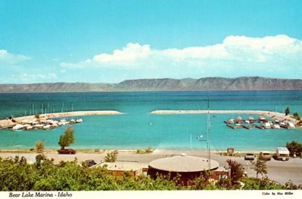
    <summary type="html"><![CDATA[<p><strong><em>Along Idaho’s forty-five-mile portion of Highway 89, travelers pass Bear Lake, a natural freshwater body that spans the Utah and Idaho state lines. The lake’s vibrant blue waters have attracted travelers and locals to enjoy its outdoor recreation opportunities since the arrival of Euro-American settlers. Regular visitors have referred to Bear Lake as the “Caribbean of the Rockies,” due to its bright blue color. </em></strong></p><img src="https://www.intermountainhistories.org/files/fullsize/a2052eb33acb8a79b958725076cfb96f.jpg" alt="Bear Lake Marina Idaho Vintage Postcard Collectible Scenic View" /><br/><p><span>Long before Euro-American settlers found Bear Lake, the Bannock, Shoshone, and Ute tribes frequented the surrounding landscape for hunting. U.S. military officers John Fremont and Benjamin Bonneville surveyed this area in 1842. Their findings paved the way for Oregon Trail travelers, who later traversed around the lake en route to Oregon. During the late 19th century, Bear Lake was an informal outdoor recreation site, attracting tourists from across the American West to enjoy boating, camping, fishing, hunting, and swimming at the lake’s bright blue waters. </span>
<span>Multiple ambitious locals recognized the site’s popularity and chose to open resorts with lodging and dining. By 1926, several private resorts operated on Bear Lake’s shores, including Bear Lake Hot Springs, Fish Haven, Ideal Beach, Lakota, and Logan Canyon. In the following decades, some of these facilities expanded to offer indoor entertainment, such as rollerskating at Lakota Resort and dancing at Fish Haven Resort. Alongside outdoor recreation, Bear Lake’s various resorts became popular sites for large gatherings like family reunions and school field trips. During the early-mid 20th century, the Bear Lake resorts received higher volumes of tourists between June and August, leaving their lodging facilities with no vacancies. The Bear Lake resorts would experience increased patronage following the extension of Highway 89 from St. Charles, Utah, to Paris, Idaho, in 1956. These businesses advertised the lake’s accessibility to Salt Lake City residents who could reach their summer getaway via the highway without being too far from home.</span>
<span>Recognizing the site’s popularity, the Utah Bureau of Land Management declared Utah’s portion of Bear Lake a state park in 1962 with plans to expand the marina and harbor that year. In 1963, the Idaho State Land Board designated the lake’s northern shore as a state park. It was not uncommon for travelers en route to Yellowstone National Park to stop and behold the unexpected beauty of Bear Lake. The site grew to such popularity in the 1970s that the two state parks closed temporarily and considered ways to control the expanding crowds. Members of the Bear Lake County Commission and the State Parks Commission in each state considered charging overnight campers additional fees, enforcing a maximum capacity, and enforcing boat speed limits. While the state park directors strove to allow the maximum number of visitors to enjoy the beaches, they agreed that certain regulations were necessary to promote a quality experience for all.</span>
<span>Bear Lake continues to be a popular outdoor tourist destination along Highway 89 throughout the year. Spring and summer visitors can enjoy biking, bird-watching, boating, camping, swimming, and water skiing, while winter visitors enjoy ice fishing for the native Bonneville Cisco whitefish. This unique fishing opportunity has made the lake a popular attraction for such an activity, especially when the fish spawn near the lake’s icy shores in late January each year. Even if highway travelers do not plan to stop at Bear Lake, its vibrant blue waters offer a uniquely scenic view as they cruise by on Highway 89.</span></p><p><em><strong><a href="https://www.intermountainhistories.org/items/show/910">For more (including 5 images) view the original article</a></strong></em></p>]]></summary>
    <published>2025-09-23T15:38:24+00:00</published>
    <updated>2026-04-17T19:32:21+00:00</updated>
    <link rel="alternate" type="text/html" href="https://www.intermountainhistories.org/items/show/910"/>
    <id>https://www.intermountainhistories.org/items/show/910</id>
    <author>
      <name>Alexandra Williams, Northern Arizona University</name>
    </author>
  </entry>
  <entry>
    <title type="html"><![CDATA[Bear Lake Rendezvous of 1827]]></title>
    <summary type="html"><![CDATA[<p><strong><em>The Bear Lake rendezvous in 1827 marked the first year under a new company. Inflated supply prices and conflicts with the local Blackfoot tribe stunted the success of this meeting.</em></strong></p><img src="https://www.intermountainhistories.org/files/fullsize/ff202bfc65cacc11854cdf61e40ccfb4.jpg" alt="Bear Lake today" /><br/><p>Bear Lake is a freshwater body on the Utah–Idaho border that is situated within a small valley, at an elevation of 5,923 feet. Eight miles long and twenty miles wide, calcium carbonates suspended in the lake water give it a unique green-blue hue, earning Bear Lake the nickname “Caribbean of the Rockies.” Fur trappers and traders from the 1827 rendezvous also referred to the area as “Sweet Lake.” The newly formed Smith, Jackson, and Sublette firm chose Bear Lake’s south shore for both the 1827 and 1828 Rocky Mountain rendezvous, making the site the new trade system’s first lakeside location. The site would have been a part of Mexico’s territory during that time. Today, the site is located near the city of Laketown, Utah.
William Henry Ashley was not in attendance at the 1827 rendezvous, as he had sold his share in the fur company to Smith, Jackson, and Sublette the previous year. However, he was still contracted to supply merchandise for the rendezvous. Fur trappers in attendance that year complained about “exorbitant” prices of supplies that year, as described by explorer Daniel Trotter Potts in a letter to a friend. He explained the difficulty of making profits in the fur trade due to these high prices, which were inflated and known as “mountain prices.” For trappers, this was one downside of the centralized rendezvous system.
In a lighter moment, when Jedediah Smith arrived at the rendezvous late, traders already present celebrated his arrival by firing a cannon. Some worried he had become lost while making the trip from California. Before he could miss the rendezvous, though, Smith met a Snake Tribe encampment north of the Salt Lake who informed him of the Bear Lake rendezvous twenty-five miles away, and he made it in time for the traders to welcome him.
The Bear Lake rendezvous of 1827 was significant due to a violent skirmish with members of the Blackfeet Nation. Allegedly, the conflict began when Blackeet individuals entered camp to murder a man and woman from the Snake tribe. The white traders already had ongoing conflicts with the Blackfeet, so they allied with Snake tribe trappers in what became a violent battle. A small number of whites were injured in the skirmish, though none died, but multiple Native Americans died. The exact number of fatalities remains unknown, however.
Bear Lake was opened as a Utah State Park in 1862. Rendezvous Beach on the south shore is named in honor of the 1827 and 1828 rendezvous held there. The lake has since become a popular attraction for tourists and sports enthusiasts with many recreational activities available such as fishing, hiking, waterskiing, and swimming. The area is also notable for its raspberries, which thrive in the Bear Lake valley’s climate. During the summer Raspberry Days festival, there are sometimes rendezvous events included where attendees can learn about frontier history and recreate the mountain man lifestyle.</p><p><em><strong><a href="https://www.intermountainhistories.org/items/show/611">For more (including 5 images) view the original article</a></strong></em></p>]]></summary>
    <published>2022-06-11T00:14:11+00:00</published>
    <updated>2026-04-17T19:32:13+00:00</updated>
    <link rel="alternate" type="text/html" href="https://www.intermountainhistories.org/items/show/611"/>
    <id>https://www.intermountainhistories.org/items/show/611</id>
    <author>
      <name>Emily Roth, Northern Arizona University</name>
    </author>
  </entry>
  <entry>
    <title type="html"><![CDATA[Beaver Creek Administrative Area Historic District Cultural Landscape]]></title>
    <summary type="html"><![CDATA[<p><strong><em>Explore the beautiful mountain range of Grand Teton National Park and sneak a peek at exemplary rustic architecture while there. </em></strong></p><img src="https://www.intermountainhistories.org/files/fullsize/50f5f2bba465e7d5d66e479abeb52569.jpg" alt="Superintendent’s residence" /><br/><p>The first development at the Beaver Creek Administrative Area in what became Wyoming’s Grand Teton National Park was in 1908, when Forest Service ranger Al Austin built the Stewart Ranger Station in what was then known as Teton National Forest. Between 1908 and 1929, there were a few small additions to the landscape, including three buildings, a road, fencing, and a flagpole. When Grand Teton became a National Park in 1929, the National Park Service took over the land and used it as a utility and administrative site. The 1930s brought new infrastructure to the park which conformed to the Park Service’s rustic building style. With funds from the New Deal program, the Park Service had a superintendent residence built, and they designed this first construction in the area to look rustic. The Civilian Conservation Corps added log cabins, garages, and buildings to the landscape. In addition, replanting natural vegetation was key to blending human development with the region’s natural aesthetic. 
The Beaver Creek Administrative Area continued to serve as the park’s headquarters from 1929 until 1958, when a new site near Moose, Wyoming replaced it. The original administrative area remains one of the easiest-to-identify National Park Service rustic sites in the United States. The use of unprocessed building materials like the lodgepole pine trees and river stones create a sense that the building grew directly out of the landscape, and the dark brown paint and green-rolled asphalt roofing meld the buildings with the natural color palette of the Teton forest. The absence of decorative design helps these man-made structures further blend into their environment. The Forest Service buildings that remain in Beaver Creek have undergone renovations since their construction in 1908 which combined the two log buildings into one under a new roof and added porches to the east and west sides of the structure.
The historic administrative area has been a topic of debate for Grand Teton National Park in years past. The buildings are still in use as housing, offices, and storage, but the NPS believes the area is an opportunity to showcase National Park designed rustic architecture. Accommodating both tourism and administrative operation requires conscience respect for the the size and design of the historic district. These buildings stand the test of time and exemplify the conservation movement and rustic architecture that the National Parks strove for in the 1930s.</p><p><em><strong><a href="https://www.intermountainhistories.org/items/show/600">For more (including 3 images) view the original article</a></strong></em></p>]]></summary>
    <published>2022-06-09T20:57:46+00:00</published>
    <updated>2026-04-17T19:32:13+00:00</updated>
    <link rel="alternate" type="text/html" href="https://www.intermountainhistories.org/items/show/600"/>
    <id>https://www.intermountainhistories.org/items/show/600</id>
    <author>
      <name>Jennifer John, Northern Arizona University</name>
    </author>
  </entry>
  <entry>
    <title type="html"><![CDATA[Beaver Meadows Visitor Center at Rocky Mountain National Park]]></title>
    <summary type="html"><![CDATA[<p><strong><em>In true Frank Lloyd Wright style, Beaver Meadows Visitor Center fits well into its natural surroundings both in color and design. It is part of the National Park Service Utility Area, which is a Historic District listed on the National Register of Historic Places.</em></strong></p><img src="https://www.intermountainhistories.org/files/fullsize/a9c16b685b2d0f4f95c46eb1efe856dc.jpg" alt="Architectural sketch" /><br/><p>On January 26, 1915, President Woodrow Wilson signed the Rocky Mountain National Park Act, establishing Rocky Mountain as a national park and securing its boundaries. Lodge keepers owned private lands throughout the park where they maintained roads, built trails, and were guides to visitors. When the first superintendent arrived, he too began to authorize construction of facilities to support visitors. As visitation increased after World War I, the simple park conveniences and private lodges became inadequate. Rangers helped build comfort stations, museums, and well-maintained trails to meet visitor expectations. After World War II, a surge of visitation to all National Parks called for updated accommodations. The Eisenhower administration agreed and approved funding for the Mission 66 program which aimed to improve park infrastructure by 1966, the 50th anniversary of the Park Service.
Rocky Mountain National Park’s Beaver Meadows Visitor Center was one of the last Mission 66 projects completed by the program. Planning for a new development started in 1956 but official proposals for construction did not begin until November 1962. Discussions over the design of the building were lengthy, but the real issue causing delays was location. Private land ownership throughout the park made finding a place to build the visitor center difficult. By September of 1962, the Park Service announced a location for the Beaver Meadows Visitor Center had been chosen after five years of debate. The tourist office was the first to be located outside of the park's main entrance and did not require an entry fee to access it. In March 1965, reviewing preliminary plans began and the Park Service announced official bidding for construction contractors. The Park Service contracted Taliesin Associated Architects, a firm made up of Frank Lloyd Wright’s apprentices, to design the new structure. On July 16, a groundbreaking ceremony officially launched construction. Issues concerning the forced air-cooling system delayed progress with production, and the center was not completed in time for the 1966 National Park Service 50th anniversary. Nevertheless, on June 24, 1967, the dedication ceremony and official opening of the Beaver Meadows Visitor Center took place. Despite being completed after the ten-year Mission 66 timeframe, this center is one of the most historically and architecturally significant National Park Service buildings in the country. 
Today the exterior remains largely unchanged from its original state. The concrete and stone exterior walls have not required any renovations due to their natural design and intention to age with the environment. The interior has experienced a few changes: originally the space to the right of the entrance had a fireplace surrounded by stone and concrete, contrasting the wood paneled walls on the adjacent side. On the left side of the lobby was a staircase that led down to the restrooms on the basement level. Also to the left was the auditorium which was the main attraction for visitors. A door on the southeast side of the room led to a balcony that provided a view of the highest mountain in the park, Long’s Peak. Now, the visitor's experience has changed. The fireplace has been covered and the area turned into a store, the balcony has been blocked by new additions, and the view of Long’s Peak is no longer part of the experience. Renovations to provide handicap access have been added, but the Park Service does its best to make sure new work conforms to the historic design of the exterior.</p><p><em><strong><a href="https://www.intermountainhistories.org/items/show/517">For more (including 4 images) view the original article</a></strong></em></p>]]></summary>
    <published>2021-10-15T09:18:50+00:00</published>
    <updated>2026-04-17T19:32:11+00:00</updated>
    <link rel="alternate" type="text/html" href="https://www.intermountainhistories.org/items/show/517"/>
    <id>https://www.intermountainhistories.org/items/show/517</id>
    <author>
      <name>Jennifer John, Northern Arizona University</name>
    </author>
  </entry>
  <entry>
    <title type="html"><![CDATA[Belknap House]]></title>
    <summary type="html"><![CDATA[<p><strong><em>Built by a state assemblyman and later owned by the Chief Justice of the Nevada Supreme Court, the Belknap House is a well-preserved example of Second Empire architecture in Nevada.</em></strong></p><img src="https://www.intermountainhistories.org/files/fullsize/8f532b5613bce46ffa99ef4f4c67384c.jpg" alt="Belknap House, facing North Street" /><br/><p>Constructed during Carson City’s heyday by state assemblyman Henry Hudson Beck in 1875, the Belknap House remains a well-preserved instance of the Second Empire style. Its distinguishing mansard roof, which curves downward from its flat top on four sides, includes two arched windows on each side, creating a more refined appearance, while also yielding additional light and living space in the second story. The exterior embraces decoration, particularly on the porch with ornamentation above the posts, alongside the motifs running above its first-story windows, called gingerbread. The bay windows facing John Street give the house greater dimension and character and provide more natural light. Most Second Empire homes are built with brick, but Beck went for the more economical wooden siding, giving the building a distinctive appearance in comparison to other residences of the same era. In 1876, only a year after finishing the house, Beck moved to Reno, looking to fund the creation of a new sawmill, and he lived there until his death.
Oscar Barber purchased the property, lived there until 1881, and sold it to Charles Belknap, a five-term Justice of the Nevada Supreme Court and former Mayor of Virginia City. Around 1890, Belknap opted to construct a single-story addition onto the western façade, adding an extra dining and living room. He also matched Beck’s exterior designs, particularly the inclusion of a look-alike porch for the second entryway. However, Belknap decided to top the add-on with a gable roof, which slops on two sides leaving a gable (the wall) in between the roof’s sides. This design decision indicates the fashionable shift towards other architectural styles in the 1890s, as Second Empire gradually became outdated. Belknap retired from the Supreme Court in 1905 and subsequently moved to the California coast, where he died in 1926.
The residence is substantial at 2,600 square feet, containing three bedrooms and two bathrooms. It went through other expansions after Belknap’s ownership, including two garages built around 1920 and 1954. Interestingly, the house also contains a 1960s-era nuclear fallout shelter, now used as a guest house. It is the only privately-held fallout shelter in Carson City. None of these additions, however, contribute to the historical significance of the site, according to the National Register of Historic Places, as they fall outside the boundaries of the original home and additions. As one of the few examples of Second Empire architecture in Carson City, the Belknap House holds a special place in Carson City’s local history and western American Architecture. Its owners successfully added it to the National Register of Historic Places in 1997. At the time of writing, it is not open to the public for visitors.</p><p><em><strong><a href="https://www.intermountainhistories.org/items/show/594">For more (including 6 images) view the original article</a></strong></em></p>]]></summary>
    <published>2022-04-16T04:21:35+00:00</published>
    <updated>2026-04-17T19:32:12+00:00</updated>
    <link rel="alternate" type="text/html" href="https://www.intermountainhistories.org/items/show/594"/>
    <id>https://www.intermountainhistories.org/items/show/594</id>
    <author>
      <name>William R. Batson, Northern Arizona University</name>
    </author>
  </entry>
  <entry>
    <title type="html"><![CDATA[Big Rock Candy Mountain — Utah]]></title>
    <summary type="html"><![CDATA[<p><strong><em>After Harry McClintock released the song “Big Rock Candy Mountain” in 1928, Utah locals placed a sign at the base of a yellow mountain outside of Richfield, labelling it as the song’s namesake because they believed the scenic area matched McClintock’s lyrical description. After the song’s popularization in the 1950s, tourists along Highway 89 considered Utah’s Big Rock Candy Mountain an attraction itself. </em></strong></p><img src="https://www.intermountainhistories.org/files/fullsize/354f372af4646cdc53dcb45586facacb.jpg" alt="Big Rock Candy Mountain UT-Utah, Lemonade Springs, Antique, Vintage Postcard" /><br/><p><span>In his 1928 song, “Big Rock Candy Mountain,” the American folk singer Harry McClintock (1882-1957) sang of a fabled paradise that he described as being bathed in perpetual sunshine, free of danger and common stressors, and flowing endlessly with delicious food and drink. The song quickly gained national popularity, leading some Utah locals to place a sign at the foot of a colorful mountain outside of Richfield, which they believed resembled the one McClintock described in the song. For the mountain’s scenic views and association with the popular song, Big Rock Candy Mountain became a local tourist attraction. Two ambitious locals, Ben Dieringer and Pratt Seegmiller, capitalized on the site’s popularity by opening a resort, including a motel, café, gift shop, and fuel station at the foot of the mountain in 1933. </span>
<span>Utah locals recognized this mountain as one of Utah’s greatest natural wonders. The mountain’s vibrant colors resulted from mineralization that occurred after layers of hot magma covered the mountain’s volcanic rock and deposited an oxidized mineral, limonite, over twenty million years ago. Today, the mountain presents a combination of multiple vibrant colors, including orange, red, white, and yellow. Locals suggest that these bright colors make the mountain look as if it is made entirely of candy and is therefore deserving of its name.</span>
<span>Throughout the mid-20th century, the Big Rock Candy Mountain Resort became a popular roadside attraction along Highway 89 and a valued community center for the residents of Piute County. Travelers could fuel vehicles, enjoy a meal at the café, rest overnight, and purchase bottled mineral water and colorful rock candy from the curio shop. Beginning in the 1950s, Dieringer brought live animals to the resort, including coyotes, deer, mountain lions, porcupines, and lynxes, and allowed visitors to pet them. He believed these encounters could help people cultivate compassion for animals. Dieringer began hosting an annual Easter egg hunt. Advertisements in the <em>Richfield Reaper</em> invited families from the nearby town to spend their Sunday at the Big Rock Candy Mountain Resort, where children could search for Easter eggs he had hidden throughout the hills behind the resort. The 1950s and 1960s were Dierringer and Seegmiller’s prime years as business owners before they retired.</span>
<span>Dieringer and Seegmiller sold the Big Rock Candy Mountain Resort to Richfield resident John Gledhill in 1974. Two years later, a fuel pump ignited a fire, destroying the service station and motel. Gledhill rebuilt the resort in 1978 despite this setback. He owned the business for twenty years in total before he filed for bankruptcy in 1994 and offered the resort for auction. Dissatisfied with the auction’s turnout, Gledhill listed the property on the real estate market for $535,000.000 in 1995. Utah locals Michael and Anne Morrey purchased the property in 1997 and advertised the site as an ideal place for family reunions, where visitors could stay at the resort’s cabins, camp, hike, or ride ATVs on the surrounding outdoor trails.</span></p><p><em><strong><a href="https://www.intermountainhistories.org/items/show/909">For more (including 4 images) view the original article</a></strong></em></p>]]></summary>
    <published>2025-09-23T15:38:24+00:00</published>
    <updated>2026-04-17T19:32:20+00:00</updated>
    <link rel="alternate" type="text/html" href="https://www.intermountainhistories.org/items/show/909"/>
    <id>https://www.intermountainhistories.org/items/show/909</id>
    <author>
      <name>Alexandra Williams, Northern Arizona University</name>
    </author>
  </entry>
  <entry>
    <title type="html"><![CDATA[Blue Fox Theatre]]></title>
    <summary type="html"><![CDATA[<p><strong><em>The first theater in Grangeville to play talking pictures, the Blue Fox introduced a modern form of entertainment to this small Idaho town. It also hosted school plays and live music, and it continues to serve the community’s entertainment needs. </em></strong></p><img src="https://www.intermountainhistories.org/files/fullsize/1336d57c9ac40d49096042cbd93aad9d.jpg" alt="Blue Fox" /><br/><p>The Blue Fox Theatre opened on May 2, 1930, in the small town of Grangeville, Idaho, three hours north of Boise. Its opening film was <em>The Gold Diggers of Broadway</em>, starring Nancy Welford and Conway Tearle. The theater’s owner, Al Wagner, developed a passion for the industry after his experiences in a local theater circuit. Wagner and his family had migrated to Cottonwood, Idaho from North Dakota in 1910. He attended the Moscow campus of the University of Idaho in the early 1920s before getting at Cottonwood’s local bank as a bookkeeper. It was during this time that Wagner first became interested in motion pictures. With his personal portable projector, Wagner traveled to neighboring towns and rented halls to show movies for the locals. In 1929, he purchased a plot of land to build his own theater and hired Contractor J.R. Adkison and designer W.T. Cregan, both from Washington state, to take on the project. While Cregan began drafting plans for the interior, Adkison broke ground on the project in November 1929.
The community eagerly awaited the completion of the project, especially since it would be the only theater in town that would play talking films, or “talkies”. The <em>Idaho Falls Free County Press</em> covered the project extensively at the end of 1929 and the beginning of 1930 leading up to the Grand Opening. Wagner hosted a contest in the newspaper to select the name, and the winner received three free tickets and a cash prize of ten dollars. Hundreds of local residents submitted suggestions for the name; among the most notable were the “Granada,” “Wagner,” “Majestic,” and “Lone Star." Runner-ups for the contest were also awarded free movie tickets for their submissions of the “Balboa,” “Alhambra,” “Wagnerian,” and “Tolo.” Resident of Lucille, Idaho J.H. Dickinson won the contest for his suggestion of “The Blue Fox Theatre,” which Wagner felt was both unique and good for promotional opportunities. After its opening, Wagner remained dedicated to serving the public and keeping the theater involved in community events. The Blue Fox hosted vaudeville shows, school plays, and live music performances in addition to its regular showing of films.
The theater has undergone significant changes over the years, both architecturally and technologically. Its current marquee with neon lighting was added in 1940 and remains operational. In 1944, a fire originating in the basement destroyed much of the interior. While Wagner had promised the community that repairs would be made as soon as possible, he worried that limited resources due to the war effort would prevent this from happening. The War Productions Board, realizing that the Blue Fox was an important source of entertainment and community outreach, prioritized the remodeling efforts. In March of 1945, Wagner installed a new sound system, air conditioning, and heating systems, and reupholstered the original chairs. The theater remains open and provides the community with entertainment for all ages. The Wagner family continues to own and operate the Blue Fox.</p><p><em><strong><a href="https://www.intermountainhistories.org/items/show/551">For more (including 3 images) view the original article</a></strong></em></p>]]></summary>
    <published>2021-12-17T05:52:29+00:00</published>
    <updated>2026-04-17T19:32:11+00:00</updated>
    <link rel="alternate" type="text/html" href="https://www.intermountainhistories.org/items/show/551"/>
    <id>https://www.intermountainhistories.org/items/show/551</id>
    <author>
      <name>Melissa Valenzuela, Northern Arizona University</name>
    </author>
  </entry>
  <entry>
    <title type="html"><![CDATA[Bryce Canyon Lodge and Deluxe Cabins - Bryce Canyon National Park]]></title>
    <summary type="html"><![CDATA[<p><strong><em><span style="font-weight:400;">In 1923, the Union Pacific Railroad created the Utah Parks Company, which connected its rail line to attractions such as Zion National Park and the North Rim of Grand Canyon National Park. The Bryce Canyon Lodge and Deluxe Cabins linked Bryce Canyon State Park to this system of resorts in 1925. </span></em></strong></p><img src="https://www.intermountainhistories.org/files/fullsize/2d65ab73bf5bf337b81a40dba1d6d45e.jpg" alt="Bryce Canyon Lodge, c. 1929" /><br/><p><span style="font-weight:400;">In 1874, Bryce Canyon became part of a cattle ranch owned by Ebenezer Bryce. His ranch was unsuccessful, but automobile tourism revitalized the area when passable roads reached what is now Zion National Park in 1917. In 1921, Utah’s state legislature accepted a proposition from Park Service director Stephen Mather that protected Bryce Canyon as a state park. Utah made no attempt to develop the area for public use, but the Union Pacific Railroad spurred development in Bryce Canyon by creating the Utah Parks Company in 1923. This connected the Union Pacific’s Cedar City spur line to Bryce Canyon, the North Rim of Grand Canyon National Park, and Zion via bus lines. By establishing a network of parks and resorts, the Union Pacific aimed to compete with other successful railroad companies such as the Northern Pacific, Atchison-Topeka Santa Fe, and Great Northern. These companies had established successful tourist attractions at the South Rim of Grand Canyon, Yellowstone National Park, and Glacier National Park. As tourism brought in profit, road construction improved access to rural points of interest like Bryce Canyon. In 1924, Congress established Utah National Park, and the Utah Parks Company constructed Bryce Canyon Lodge and Deluxe Cabins in the same year to provide visitors with accommodations. Congress enlarged Utah National Park and renamed it Bryce Canyon in 1928. </span>
<span style="font-weight:400;">The Utah Parks Company enlisted Gilbert Stanley Underwood, one of the Union Pacific’s consulting architects, to design Bryce Canyon Lodge. Underwood’s designs are notable for their commitment to rustic architecture, which used natural materials and textures to blend a building with its natural surroundings. He utilized locally quarried stone and large, exposed wooden details throughout the structure, figuratively connecting the building to its location. After the company completed the original building in 1925, it added two new wings in 1926 to make room for an increasing number of visitors. The Utah Parks Company constructed fifteen deluxe guest cabins the following year in a pine grove near the main structure. Their design used rough stone and natural wood to imitate the design of Bryce Canyon Lodge. </span>
<span style="font-weight:400;">During the 1950s, the National Park Service renovated Bryce Canyon Lodge to make room for updated amenities. The hotel originally housed a barber shop, but the Park Service replaced it with a soda fountain. The Park Service also enlarged a road at the hotel’s front entrance to make room for larger vehicles, but the Park service expanded a plaza outside Bryce Canyon Lodge’s front entrance by removing the original bus lane in 1989. In 1985, the Park Service removed sixty-one of the lodge’s original sixty-seven standard cabins. The Sunrise Motel and Sunset Motel replaced them. In 1995, the National Register of Historic Places officially listed forty-two buildings in Bryce Canyon, including Bryce Canyon Lodge. This restricted future renovations, allowing the complex to retain most of its architectural significance. Today, Bryce Canyon Lodge operates as a historic hotel alongside five standard cabins and fifteen deluxe cabins. </span></p><p><em><strong><a href="https://www.intermountainhistories.org/items/show/843">For more (including 5 images) view the original article</a></strong></em></p>]]></summary>
    <published>2024-05-29T21:42:39+00:00</published>
    <updated>2026-04-17T19:32:19+00:00</updated>
    <link rel="alternate" type="text/html" href="https://www.intermountainhistories.org/items/show/843"/>
    <id>https://www.intermountainhistories.org/items/show/843</id>
    <author>
      <name>Kaylen Wilson, Northern Arizona University </name>
    </author>
  </entry>
</feed>