<?xml version="1.0" encoding="UTF-8"?>
<feed xmlns="http://www.w3.org/2005/Atom">
  <title type="text">Intermountain Histories</title>
  <updated>2026-06-16T14:34:55+00:00</updated>
  <generator uri="http://framework.zend.com" version="1.12.20">Zend_Feed_Writer</generator>
  <link rel="alternate" type="text/html" href="https://www.intermountainhistories.org/"/>
  <link rel="self" type="application/atom+xml" href="https://www.intermountainhistories.org/items/browse?output=rss2"/>
  <id>https://www.intermountainhistories.org/</id>
  <author>
    <name>Intermountain Histories</name>
    <uri>https://www.intermountainhistories.org</uri>
  </author>
  <link rel="hub" href="https://pubsubhubbub.appspot.com/"/>
  <entry>
    <title type="html"><![CDATA[Lake Lowell: Transforming Treasure Valley]]></title>
    <summary type="html"><![CDATA[<p><strong><em>The Reclamation Act of June 17, 1902, aimed to create proper irrigation systems that could provide water access for residents of western states. Lake Lowell was one of those projects.</em></strong></p><img src="https://www.intermountainhistories.org/files/fullsize/8dafc9cce562e3302960bcf13f35ebe2.jpg" alt="Building up" /><br/><p>Under the direction of the 1902 Reclamation Act—congressional legislation intended to irrigate western states and provide greater access to water—the Bureau of Reclamation approved and developed Lake Lowell, starting in 1902 and finishing in 1909. Three dams—the Upper, Middle, and Lower Embankments (embankments are walls of earth or stone built to prevent a river from flooding an area)—surround a natural depression southwest of Nampa, Idaho to form the lake. A fourth wall, called the East Embankment, was added later to protect farmsteads on the eastern end of the reservoir.
In the irrigation off-season, the Boise River Diversion Dam and New York Canal provide most of Lake Lowell’s volume, discharging water intp the upper end of the lake, where there is a capacity ranging from 12.7 feet on the Middle Embankment to 65 feet on the Upper. During the irrigation season, Lake Lowell becomes one of the major irrigation providers for Canyon County agriculture. With the capacity to irrigate over 200,000 acres of land, it is one of the American West’s largest off-stream reservoirs.
As with many other western irrigation projects, Lake Lowell presented a significant opportunity for economic growth and restructured the relationship between people and their environment. Along with other government investment projects that opened the area to construction and farming, irrigation attracted migrants from the Midwest who worked as laborers to develop the dam and as farmers to till the land. In 1900, the census counted 161,772 people living in Idaho; by the 1920 census, the population had more than doubled to 431,866 people. This growth was sharpest in southwestern Idaho, which grew by 130% during this twenty-year period as agricultural and ex-urban communities transformed Treasure Valley into fertile land. Lake Lowell made that change possible.
In addition to serving local farms, towns, and cities, Lake Lowell also plays a role in how people and other living things interact with the region’s nature. The lake hosts the Deer Flat Reservoir, one of the oldest refuges in the National Wildlife Refuge System. As for humans in nature, Lake Lowell is a popular destination for numerous outdoor activities, including boating, swimming, fishing, birdwatching, hiking, and hunting.</p><p><em><strong><a href="https://www.intermountainhistories.org/items/show/629">For more (including 5 images) view the original article</a></strong></em></p>]]></summary>
    <published>2022-06-30T21:27:42+00:00</published>
    <updated>2026-04-17T19:32:13+00:00</updated>
    <link rel="alternate" type="text/html" href="https://www.intermountainhistories.org/items/show/629"/>
    <id>https://www.intermountainhistories.org/items/show/629</id>
    <author>
      <name>Legna Roximar Morales, College of Idaho</name>
    </author>
  </entry>
  <entry>
    <title type="html"><![CDATA[Idaho’s Territorial Capital Dispute]]></title>
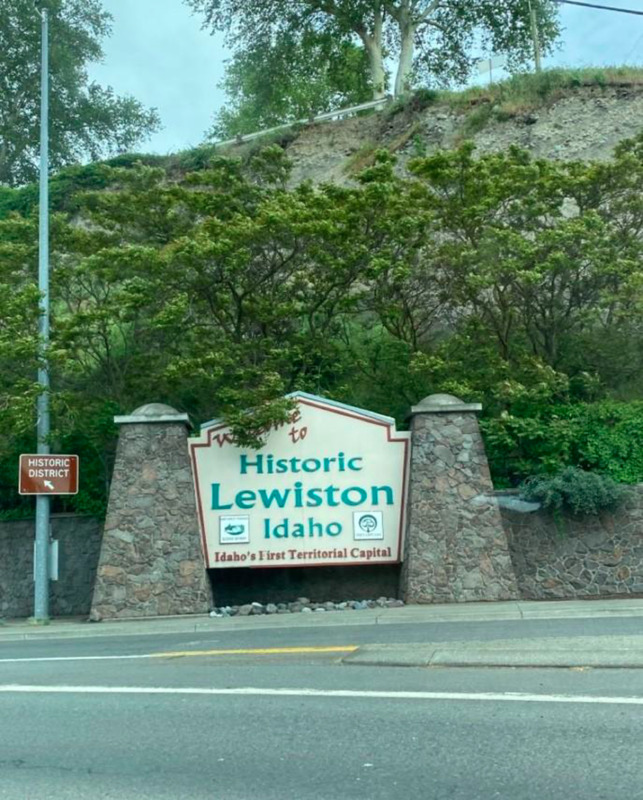
    <summary type="html"><![CDATA[<p><strong><em>Lewiston was Idaho's first territorial capital, but the title was short-lived. Many disputes over moving the capital down to Boise ensued between the people of Lewiston and the people of Boise, contributing to a longstanding divide between northern and southern Idaho.</em></strong></p><img src="https://www.intermountainhistories.org/files/fullsize/acc53b1a3c757d53c6ac8a90857a5ee8.jpg" alt="First" /><br/><p>A nineteenth-century dispute over where to place the state capital dispute helped create a regional divide that persists in Idaho to this day. It all started when westward settlers found gold in 1860, leading many to migrate to the Rocky Mountains in hopes of striking it rich. Settlers found gold in the Clearwater River, in northern Idaho, and some formed mining camps, one of which was Lewiston. As the settler population grew, many in the area called for establishing a seat of United States government closer than Olympia, Washington. In response, in March 1863, territorial governor William H. Wallace pronounced Lewiston the capital of Idaho. Wallace chose this location because in addition to the gold, there was already an established transportation and communication system that linked northern Idaho to other U.S. states and territories.
After the discovery of gold in 1862 in the Boise Basin, however, eager settlers rushed to the southern part of the territory. At the same time, gold had depleted up north in Lewiston, even further accelerating the southward migration. With most of the settler population now residing in the south, moving the capital seemed logical, especially since mountainous terrain made traveling between Boise and Lewiston difficult.
This turned out to be easier said than done, however. The territorial legislature, primarily made up of representatives from northern Idaho, failed the first initiative to change Idaho’s capital. However, in 1864 Idaho’s number of legislative representatives changed to accommodate the difference in population, leaving three representatives for the north and four for the south. This change in political power—plus pressure from H. C. Riggs, one of Bosise’s founders—convinced acting governor Caleb Lyon to move the capital to Boise. On November 23, 1864, Riggs introduced a bill to make Boise the capital. It passed six days later, and Lyon signed it into law.
Rather than fix the problem, this may have only made it worse. Governor Lyon fled to nearby Walla Walla, Washington, and sent a trusted official to retrieve the official documents from the acting secretary of Lewiston. After a stalemate over who had rights to the papers, and where the capital would officially reside, President Lincoln’s territorial secretary C. DeWitt Smith went to serve as acting governor of Idaho. With help from Fort Lapwai soldiers, Smith obtained the documents and traveled to Boise, where he put the new law into effect.
In the end, moving the capitol from Lewiston to southern Idaho left its residents with a sense of lost pride. This sparked a cultural divide between northern and southern Idaho that continues to this day. To this day, downtown Lewiston hosts a sign proclaiming the city “Idaho's First Territorial Capital,” demonstrating that the residents remember their city’s history and will not let people forget Idaho’s original territorial capital.</p><p><em><strong><a href="https://www.intermountainhistories.org/items/show/628">For more (including 3 images) view the original article</a></strong></em></p>]]></summary>
    <published>2022-06-30T20:51:21+00:00</published>
    <updated>2026-04-17T19:32:13+00:00</updated>
    <link rel="alternate" type="text/html" href="https://www.intermountainhistories.org/items/show/628"/>
    <id>https://www.intermountainhistories.org/items/show/628</id>
    <author>
      <name>Dawson Packwood, College of Idaho</name>
    </author>
  </entry>
  <entry>
    <title type="html"><![CDATA[Hells Canyon Dam]]></title>
    <summary type="html"><![CDATA[<p><strong><em>Straddling the Idaho–Oregon border and holding firm to the walls of Hells Canyon, the Hells Canyon Dam provides hydroelectric power and irrigation channels to surrounding localities. A creation of the Idaho Power Company, the concrete dam is one of three in the Hells Canyon Complex, the largest privately-owned hydroelectric power complex in the nation, whose motivations and consequences can be felt politically and ecologically.</em></strong></p><img src="https://www.intermountainhistories.org/files/fullsize/010642938f4450485d7ddd6aff0409f0.jpg" alt="Damming Hells Canyon" /><br/><p>The Hells Canyon Complex was controversial before even being built, ever since the Idaho public scrutinized the Idaho Power Company’s request to license three dams on the Snake River in 1947. During the New Deal era, public power—a method of energy administration defined in which communities owned infrastructure under local government—was the norm for hydroelectricity; while Idaho Power wanted to privately run three dams, advocates for public power in the region instead contended against Idaho Power in favor of establishing a single, high dam. After a long battle, private power won when the Federal Power Commission issued Idaho Power a license in 1955, allowing them to build a private hydroelectric complex, in turn signaling a decline of public power’s favor nationwide. Due to the Hells Canyon dam construction in the deepest gorge on the North American continent, the construction process proved difficult, and builders had to dig a twenty-three-mile access road into the Idaho side of the canyon. Along with the road, contractors set up offices, facilities, housing, and a mess hall for construction workers. In a matter of six months, the Hells Canyon Dam’s construction was complete in 1967, and it began generating electricity shortly after.
The political controversy in the postwar years about whether hydropower was something to be publicly or privately owned has roots deep in the ecological. The Hells Canyon Complex sits on the Snake River Basin, a desert ecosystem, while many of the models that public ownership advocates used were based on dams built on the Columbia River Basin, which was forested and mountainous. Because of the ecological differences inherent to these basins, people interacted differently with these water systems, and as a result, their priorities varied in what services a dam should provide. In the Columbia Basin, priority was given to energy production, while in the Snake Basin, priority was given to irrigation. This is largely due to the relationship people had with the land. In the Snake Basin, people cultivated the land for crop harvest, so they wanted the Hells Canyon Complex to have irrigation as its chief operating principle. This gave wind to Idaho Power’s licensing for the three Snake River dams; a single high dam would better serve power generation, but Idaho Power contended that the three-dam complex better served irrigation.
While ecology shaped Hells Canyon Dam, the dam also reshaped the environment. By its very design, the Hells Canyon Complex has no passage for andronomous fish species, a type of fish that migrates from freshwater to the ocean in the Snake and Columbia Rivers. Limiting certain fish species’ ability to access any of the upper Snake River Basin between the complex to Shoshone Falls has dramatically reduced the species’ population and disturbed several ecosystems. This can be traced back to the general neglect of biological research before the construction of dams along the Columbia and Snake Rivers.</p><p><em><strong><a href="https://www.intermountainhistories.org/items/show/627">For more (including 3 images) view the original article</a></strong></em></p>]]></summary>
    <published>2022-06-30T19:53:46+00:00</published>
    <updated>2026-04-17T19:32:13+00:00</updated>
    <link rel="alternate" type="text/html" href="https://www.intermountainhistories.org/items/show/627"/>
    <id>https://www.intermountainhistories.org/items/show/627</id>
    <author>
      <name>Hunter Marang, College of Idaho</name>
    </author>
  </entry>
  <entry>
    <title type="html"><![CDATA[Long Valley Finnish Church]]></title>
    <summary type="html"><![CDATA[<p><strong><em>The Long Valley Finnish Church was a crucial meeting place for Finnish Lutherans. The building continues to serve and educate the people of the area to this day.</em></strong></p><img src="https://www.intermountainhistories.org/files/fullsize/fe4390b086e8d75b5c5f75d81466c973.jpg" alt="Lasting legacy" /><br/><p><span>Following decades of struggle for independence from the Russian government and its anti-Finnish policies, numerous Finns left their homeland to migrate to the United States in search of religious and political freedom. Between 1900 and 1930, about 85 Finnish families traveled to Idaho and settled in Long Valley, southwest of Clear Creek and southeast of Hurday Creek. The Long Valley Finnish settlement became the largest Finnish community in the state of Idaho, centered around the Lutheran Church and celebrating Finnish culture. </span>
<span>These Finnish settlers took advantage of the 1862 Homestead Act, which allowed any adult citizen or intended citizen who had never fought against the United States government to claim 160 acres of land surveyed by the government. Contrary to popular perception, this land was not empty but had long been occupied by the Shoshone and Nimíipuu. The Homestead Act required the new property owners to live on and cultivate the land, leading most of the Long Valley Finns to become farmers or loggers.</span>
<span>The Lutheran Church was the foundation of the Long Valley Finnish community.  This community of worship established a physical location in 1917, when they built the Long Valley Finnish Church on an acre plot in Lake Fork, Idaho. The main hall of the church is forty-eight feet long and twenty-six feet wide, supplying ample space to worship and gather. The Long Valley Finnish Church was a cornerstone for the Finns as a place for the people to worship according to their Lutheran faith and come together as a community. People living in the area still use the chapel to this day for select worship services, funerals, and more.</span>
<span>Long Valley Finnish Church stands approximately 350 feet southwest of the Finnish cemetery where the majority of Finnish immigrants were laid to rest. Finnish Ladies Aid Society maintains and preserves the building, which today is one of the only remaining artifacts in Idaho representing the Finnish migration to the state.</span></p><p><em><strong><a href="https://www.intermountainhistories.org/items/show/626">For more (including 3 images) view the original article</a></strong></em></p>]]></summary>
    <published>2022-06-26T02:56:16+00:00</published>
    <updated>2026-04-17T19:32:13+00:00</updated>
    <link rel="alternate" type="text/html" href="https://www.intermountainhistories.org/items/show/626"/>
    <id>https://www.intermountainhistories.org/items/show/626</id>
    <author>
      <name>Cooper Leaf, College of Idaho</name>
    </author>
  </entry>
  <entry>
    <title type="html"><![CDATA[Stibnite Mine: Dormant but Not Dead]]></title>
    <summary type="html"><![CDATA[<p><strong><em>Nestled up in the mountains above Valley County, Idaho, in the Payette National Forest, beyond even the most remote town in the region, and in the middle of an otherwise densely green forest, sits Stibnite the currently dormant Stibnite Mine: a landscape of stripped earth, dead grass, rock, and the infamous “Glory Hole,” an open pit with a sluggish pond of waste. </em></strong></p><img src="https://www.intermountainhistories.org/files/fullsize/20dc0bda7b67c07ecd976075edfdf300.jpg" alt="Glory ole" /><br/><p>The Stibnite Mine, located in what is now the Payette National Forest, started during the 1899 Thunder Mountain gold rush. The first known claims were staked by Albert Hennesy in 1914. Those were later purchased by the United Mercury Mining Company of Boise and optioned by the San Francisco-based Bradley Mining Company in 1927 for mining and milling gold. Stibnite’s most active period of operation came during World War II. A core sample taken from the site revealed an abundance of tungsten and high-grade antimony, materials crucial to the war effort for supplying reinforced armor, ammunition shells, fire resistant clothing, and electrical chips. Between 1941 and 1945, Stibnite miners provided 90% and 40$ of the nation's domestic supply of antimony and tungsten, respectively. 
To extract so much material, Bradley Mining expanded Stibnite into a much larger beast. Instead of digging mine shafts, Bradley initiated open pit mining. To process the raw material, the company installed heavier equipment, such as a smelter and mill. When WWII ended, the demand for antimony and tungsten dwindled, and Stibnite’s profits with it. From this point forward, Stibnite operated off and on throughout the years, passing through different companies several times until it completely shut down in 1997.
The end of active mining didn’t end Stibnite’s story, though; instead, environmental issues took front and center stage. After years of mining, Stibnite had accumulated a massive amount of waste, raising the problem of what to do with it. One major point of contamination came from the Bradley Tailing Pile Dump in the Meadow Creek Floodplain. Preventing massive amounts of mine waste from washing downriver into the valley required diverting Meadow Creek twice. Even after this intervention, an environment and water quality survey conducted periodically from 2011 to 2017 around the Stibnite–Yellow Pine area, which included Meadow Creek, revealed elevated levels of mercury, antimony, and arsenic contamination.
In addition to efforts to minimize the effect of tailings leeching contaminants into the waterways below the site, there have also been efforts to clean up and restore the environmental quality of Stibnite itself. For example, high school students conducted a multi-year tree planting project. Alongside these restoration and monitoring efforts have also been proposals to reevaluate the area’s continued resource potential by Perpetua Resources, the company now in charge of the Stibnite site. As of now, there has been an ongoing bid to reopen the Stibnite area mining once again—gold this time—bringing Stibnite’s mining story up to the present but not necessarily to its end.</p><p><em><strong><a href="https://www.intermountainhistories.org/items/show/625">For more (including 3 images) view the original article</a></strong></em></p>]]></summary>
    <published>2022-06-26T01:59:56+00:00</published>
    <updated>2026-06-16T14:34:55+00:00</updated>
    <link rel="alternate" type="text/html" href="https://www.intermountainhistories.org/items/show/625"/>
    <id>https://www.intermountainhistories.org/items/show/625</id>
    <author>
      <name>Meghan Laughlin, College of Idaho</name>
    </author>
  </entry>
  <entry>
    <title type="html"><![CDATA[Queen Aggie: Boise’s Black Madam]]></title>
    <summary type="html"><![CDATA[<p><strong><em>Levy’s Alley was Boise’s most notorious restricted district. After Davis Levy’s death, Agnes Bush became one of its most famous proprietors.</em></strong></p><img src="https://www.intermountainhistories.org/files/fullsize/0cad4d80950205d12f20127cfaf8287c.jpg" alt="Parlor" /><br/><p>Named for Davis Levy, the original owner of many of the cribs that lined the alley in the 1880s, Levy’s Alley ran behind the 600 block of Main Street in downtown Boise. While the alley was not the only restricted district in the city, it was the most notorious, and the majority of Boise’s most famous madams and sex workers lived and worked there. One such person was Agnes Bush, also known as “Queen Aggie,” a Black woman who operated multiple cribs and parlor houses in Boise.
Bush was one of Levy’s prior tenants, and after he died, she acquired some of the property for herself and expanded a pleasure business of her own. Bush soon ran multiple rooms in the district, by then nicknamed “Levy’s Alley” after Davis, which she rented out by individual women known as “crib girls.” She was known not only as a successful businesswoman but also as a prominent citizen, and the <em>Idaho Daily Statesman</em> frequently wrote about her charitable acts for the poor and children in need. Bush also made important donations to the city and formed long-standing financial and “friendly” ties with the press and local law enforcement. These relationships were supplemented by expensive gifts such as a diamond-encrusted badge she gave to Boise police chief B. F. Francis and a $250 diamond ring to local journalist C. Miles. These gifts and activities both ensured and announced Bush’s prominent role in Boise, for which she earned the nickname “Queen Aggie.”
Agnes Bush stands out because she was a Black woman. As a prominent figure in the Boise community with ties to law enforcement, as well as significant property holdings and wealth, she stands as a curious anomaly in the history of the Treasure Valley and the broader region. Though there was white supremacist activity in the area given Boise’s proximity to Oregon (which white residents established officially as a white-only state in its 1859 constitution), Bush was a major player in her community. Indeed, local government and law enforcement typically tolerated sex workers in Boise until 1909, when national sentiments turned against the traditional practice of relegating sex workers to restricted districts in favor of completely expelling such para-legal practices in the name of public health. That year, Congress passed the Mann Act, and local Boise officials began targeting their city’s sex workers for fear of federal intervention.
After being run out of the city, Bush moved to Portland, Oregon to live with one of her sons while she suffered from partial paralysis. In 1910, the <em>Statesman</em> reported her death in Portland and revealed her “real name,” Frances Richardson. Despite how her story ended, Bush’s success and her ties to the community suggest the rich tapestry of people that comprised the state of Idaho’s early years and reflect the fascinating and dynamic time in which she lived.</p><p><em><strong><a href="https://www.intermountainhistories.org/items/show/624">For more (including 3 images) view the original article</a></strong></em></p>]]></summary>
    <published>2022-06-25T23:56:23+00:00</published>
    <updated>2026-04-17T19:32:13+00:00</updated>
    <link rel="alternate" type="text/html" href="https://www.intermountainhistories.org/items/show/624"/>
    <id>https://www.intermountainhistories.org/items/show/624</id>
    <author>
      <name>Gabriel Herring, College of Idaho</name>
    </author>
  </entry>
  <entry>
    <title type="html"><![CDATA[The Big Burn of 1910]]></title>
    <summary type="html"><![CDATA[<p><strong><em>The summer of 1910 was very dry in the northwest United States, with absolutely no precipitation May through July. The resulting fire was so destructive that Americans named it “the Big Burn.”</em></strong></p><img src="https://www.intermountainhistories.org/files/fullsize/1aac363c55b106acdcbdfdad043cc9a0.jpg" alt="Scars of Wallace, ID" /><br/><p>In the summer of 1910, every step through the forests in the Bitterroot Mountains between Idaho and Montana could meet with a resounding <em>crunch</em> from the arid twigs and leaves. The season had been extremely dry, with no rain at all from May through July.
On the night of July 26, a lightning storm swept across the Bitterroots. Thunder roared through the valleys, but there was no rainfall. By the following morning, nearly a thousand fires had sprung up around the region, sparked by the lightning. In the following weeks, even more blazes emerged. Sparks, thrown by trains rumbling through the dense forest had no trouble lighting the desiccant woodland, adding to the crisis. By the middle of August, there were 2,500 separate fires burning in Idaho and Montana.
On the morning of August 20, a breeze picked up through the Coeur d’Alene National Forest and the St. Joe Mountains. The wind gradually intensified throughout the day. Before the firefighters knew it, they were dealing with gusts of up to 70 mph. Hurricane-like winds pushed together hundreds of fires. By this point, there was virtually no hope of containing the fire. The Big Burn had started.
The dry wilderness was like an endless source of fuel, and he giant blaze devoured everything in its path. Flaming trees were pulled from the ground and tossed like mere sticks while dry timber caught fire and instantly exploded into a ball of sparks. Firefighters that survived reported that it was near impossible to outrun the heat because the inferno moved at the speed of a charging horse. Those with a head start had a chance of survival; most others did not. Over the course of two days, the Big Burn torched three million acres of land. A third of Wallace, Idaho—a town of three thousand people—burned to the ground. The fire almost completely leveled the mining towns of Grand Forks, Idaho and Taft, Montana. Eighty-six people died, seventy-eight of whom were firefighters.
It was soon clear that the Big Burn was the most destructive fire the United States Forest Service had ever seen. The fire would also be recognized as the most significant wildfire emergency because of its deep impact on future forest policies. The disaster inspired a wave of priority and policy concerning national land. The incredible loss of life and forest showed the Forest Service needed serious recognition from the people. Donations poured in, and Congress doubled the organization’s budget. Parks and forest stations hired more staff and established resources in preparation of another wildfire catastrophe. The disaster of 1910 imprinted on the nation how dangerous fire could be; it was a lesson learned at incredible human cost.</p><p><em><strong><a href="https://www.intermountainhistories.org/items/show/623">For more (including 5 images) view the original article</a></strong></em></p>]]></summary>
    <published>2022-06-25T06:54:15+00:00</published>
    <updated>2026-04-17T19:32:13+00:00</updated>
    <link rel="alternate" type="text/html" href="https://www.intermountainhistories.org/items/show/623"/>
    <id>https://www.intermountainhistories.org/items/show/623</id>
    <author>
      <name>Brennen Donahue, College of Idaho</name>
    </author>
  </entry>
  <entry>
    <title type="html"><![CDATA[Aryan Nations in Coeur d’Alene, Idaho: Is the state “Too Great for Hate?”]]></title>
    <summary type="html"><![CDATA[<p><strong><em>Coeur d’Alene is the largest city in Northern Idaho, nestled among the Rocky Mountains and a picturesque lake. It was also home to a major compound of the Aryan Nations.</em></strong></p><img src="https://www.intermountainhistories.org/files/fullsize/2da7685c12ed5a2ea90e86e36e9487ae.jpg" alt="Founder of the Aryan Nations" /><br/><p>From the early-1970s arrival of Aryan Nations leader Richard Butler, to the March 2020 Idaho House’s failed vote for a “Too Great for Hate” specialty license plate, the state of Idaho has in recent years struggled over both the presence and meaning of modern white supremacy within its borders. Shortly after moving to Idaho, Butler established an Aryan Nations headquarters in rural Kootenai County on a twenty-acre site just north of Coeur d’Alene. Butler used funding he had saved and donations from fellow worshippers to begin holding services for his own congregation of the Church of Jesus Christ-Christian, a group founded in the 1940s that promulgated white supremacy and antisemitism. Butler’s compound included an adjoined print shop for publishing books, fliers, posters, and pamphlets filled with racist propaganda and antisemitic caricatures. The group led parades that gathered large crowds of youths in downtown Coeur d’Alene alongside annual summits at the compound. In the mid-1990s, the Aryan Nations began running its own website, one of the first dedicated sites for recruiting white supremacists. The religious tenor of Butler’s compound was a major draw for many who saw him as a prophetic individual, and he claimed a religious freedom right to spread his message of hate. From this headquarters, Butler preached white supremacy and exclusion to his followers, making the area synonymous with white supremacy.
However, many residents of Coeur d’Alene felt distressed at Butler’s growing presence. In 1981, Butler’s followers and rivals engaged in violent conflict, and someone defaced a local Jewish restaurant with antisemitic grafitti. This brought the compound and the town to the attention of the Kootenai County Task Force on Human Relations. The brainchild of local activists Tony Stewart, Norman Gissel, and Marshall Mend, the task force rallied locals to advocate against hate by using community outreach programs to speak against white supremacy and by intervening in disputes involving Butler and his supporters.
The advocacy group finally made headway when they won a $6.3 million lawsuit against Butler’s group for violating local codes. Stewart, Gissel, and others involved in that campaign were loath to offer their strategy as a solution for other cities, but they say their approach might be one way to address white supremacy in the US and around the world. Bankrupted by the suit, the Aryan Nations lost possession of their local property. Idaho firefighters used the compound buildings for arson investigation training, eventually burning down every structure.
The Carr Foundation later purchased the land and gifted it to the North Idaho College Foundation on the condition that they redevelop it into a “peace park.” However, in 2019 NICF obtained the Carr foundation’s permission to instead sell the land in a favorable market to fund an endowment for human rights education.
The task force’s victory over the Aryan Nations does not mean the struggle against white supremacy has concluded. Coeur d’Alene remains a town of mixed emotions between those who allow racism to flourish and those who believe Idaho can be “too great for hate.”</p><p><em><strong><a href="https://www.intermountainhistories.org/items/show/622">For more (including 3 images) view the original article</a></strong></em></p>]]></summary>
    <published>2022-06-25T05:20:37+00:00</published>
    <updated>2026-04-17T19:32:13+00:00</updated>
    <link rel="alternate" type="text/html" href="https://www.intermountainhistories.org/items/show/622"/>
    <id>https://www.intermountainhistories.org/items/show/622</id>
    <author>
      <name>Omotayo Akingba, College of Idaho</name>
    </author>
  </entry>
</feed>