<?xml version="1.0" encoding="UTF-8"?>
<feed xmlns="http://www.w3.org/2005/Atom">
  <title type="text">Intermountain Histories</title>
  <updated>2026-04-17T19:32:17+00:00</updated>
  <generator uri="http://framework.zend.com" version="1.12.20">Zend_Feed_Writer</generator>
  <link rel="alternate" type="text/html" href="https://www.intermountainhistories.org/"/>
  <link rel="self" type="application/atom+xml" href="https://www.intermountainhistories.org/items/browse?output=rss2"/>
  <id>https://www.intermountainhistories.org/</id>
  <author>
    <name>Intermountain Histories</name>
    <uri>https://www.intermountainhistories.org</uri>
  </author>
  <link rel="hub" href="https://pubsubhubbub.appspot.com/"/>
  <entry>
    <title type="html"><![CDATA[“A Path Forward”: Celebrating Women&#039;s Suffrage in Utah]]></title>
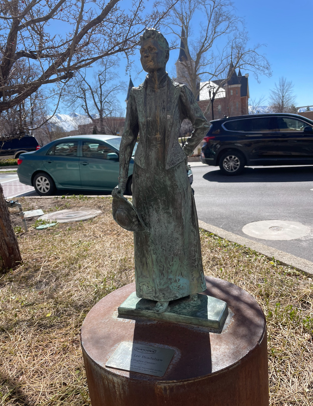
    <summary type="html"><![CDATA[<p><strong><em>“A Path Forward” was built in 2020 in Salt Lake City, Utah, to celebrate 150 years since women first voted in Utah, and 100 years since the 19th Amendment gave women throughout the United States the right to vote. The memorial, located near the Utah State Capitol, highlights women’s suffrage leaders and movements for women’s rights in Utah, in the United States, and for women of color. </em></strong></p><img src="https://www.intermountainhistories.org/files/fullsize/1854c046bfba836fd7f45e298b4376f2.jpg" alt="Archways" /><br/><p>On February 14, 1870, Seraph Young voted in Utah two days after Utah’s territorial legislature granted women the right to vote. She was, in the words of <i>Better Days 2020</i>, the "first woman to vote under a women’s equal suffrage law" in the United States. Six months later, women in Utah had the opportunity to vote in the general election that took place. The hope for equality for women in Utah and the United States was on the horizon.
However, seventeen years later, the United States federal government revoked the voting rights of Utah women as part of the anti-polygamy Edmunds–Tucker Act of 1878, which disfranchised all women in Utah, including whether or not they Latter-day Saints. However, Utah’s women continued to campaign for their voting rights. In 1894, just four years after the practice of polygamy officially ended in the Church of Jesus Christ of Latter-Day Saints, the United States passed the Enabling Act, which invited Utah to apply for statehood. Utah became a state in 1896, and the constitutional convention included Article Four in the state constitution, which granted women the right to vote and hold office. Twenty-four years later, in 1920, Congress finally granted women across the United States the right to vote with the ratification of the 19th Amendment.
The fight for women’s rights in America did not end here. Other acts were passed through the years that protected and enforced voting rights for women of color. For example, the Voting Rights Act of 1965 secured African Americans’ right to.
The memorial “A Path Forward” takes visitors through a timeline of these milestones of women’s suffrage in Utah and the United States. Tourists first follow footsteps engraved on the ground of the monument honoring Seraph Young as the first woman to vote in a United States election. Next to the footsteps is a sculpted table displaying the Enabling Act. Article 4 of the Utah Constitution is etched on the ground next to the table. A series of arches, each one progressively wider than the previous, represents the expansion of women’s suffrage rights. The first arch includes quotes from suffragists who played a significant role in the women’s suffrage movement including Sojourner Truth, Emmeline B. Wells, Martha Hughes Cannon, Susan B. Anthony, and many more. Emmeline B. Wells wrote in her journal, “I desire to do all in my power to help elevate the condition of my own people, especially women.” The “A Path Forward” monument honors courageous suffragists who, like Wells, fought for women’s right to vote. Today, we have the opportunity to honor them and their valiant efforts.</p><p><em><strong><a href="https://www.intermountainhistories.org/items/show/561">For more (including 3 images) view the original article</a></strong></em></p>]]></summary>
    <published>2021-12-18T06:45:38+00:00</published>
    <updated>2026-04-17T19:32:12+00:00</updated>
    <link rel="alternate" type="text/html" href="https://www.intermountainhistories.org/items/show/561"/>
    <id>https://www.intermountainhistories.org/items/show/561</id>
    <author>
      <name>Kate Hill, Brigham Young University</name>
    </author>
  </entry>
  <entry>
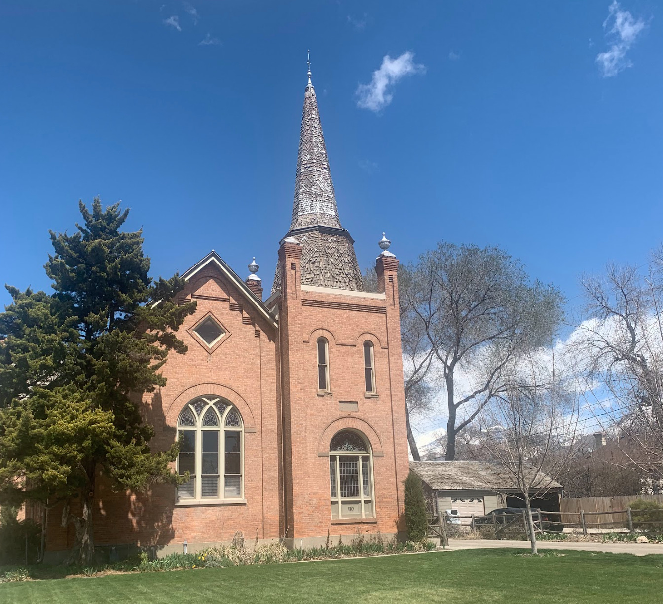
    <title type="html"><![CDATA[American Fork Second Ward Meeting House]]></title>
    <summary type="html"><![CDATA[<p><strong><em>The American Fork Second Ward Meeting House was built in response to the expansion of the American Fork settlement. Latter-Day Saints attended meetings there for almost eight decades. Although its use has changed, today it remains an excellent example of early 20th century gothic architecture.</em></strong></p><img src="https://www.intermountainhistories.org/files/fullsize/6368158aa6c18f215b83f77b7eb32afd.jpg" alt="East side steeple, American Fork Meeting House " /><br/><p><span style="font-weight:400;">The American Fork Second Ward Meeting House, located in American Fork Utah, was constructed in 1903 by members of The Church of Jesus Christ of Latter-day Saints. The building was originally proposed by Bishop Joseph H. Storrs on September 29, 1901. After a unanimous vote in favor of building the meeting house, plans for its construction began immediately. The ward members donated their time, talents, and money to the construction of the building. Though still under construction, they began using the meeting house in 1903. Eventually the steeple was finished, all debts were paid, and the meeting house was dedicated on February 17th, 1909. The total cost of the building was $10,000.20. In 1929 the ward members voted to expand the building to house all auxiliaries. The expansion and remodel included updating the chapel in the southeast section of the building beneath the steeple and the addition of a new recreational hall. The construction resulted in the church's current U-shape. John L. Firmage and his wife, members of the ward, donated $15,000 to the remodel. As a result, the addition was often referred to as the Firmage recreational hall. Architect Don Carlos Young, of Young and Hansen Architects, designed the renovation in the original gothic style. The total cost of the project was $48,555.54 by the end of the project. </span>
<span style="font-weight:400;">After the remodel, the updated chapel was used only for sacred purposes while the recreation hall was used for all other activities. The recreation hall was frequently the location of wedding receptions, dramas, and other community gatherings. The renovation also created enough space for classrooms to accommodate Sunday School and other auxiliary meetings. It even included offices for Bishopric members. </span>
<span style="font-weight:400;">The American Fork Second Ward utilized the building until the early 1980s when it was abandoned for a newer meeting house. In 1984 the abandoned church building was purchased by Michael Bigelow, who owned the building in 2023. An application was submitted for the meeting house to become a historical site in November 1991 and the historical status was granted in 1992. Bigelow has since made small updates to accommodate a residence for his family on the upper floor Sunday School room, and minor changes to utilize the space for their pipe organ design and construction business that is on the main and basement levels. The Bigelow family has been careful to maintain the original gothic architecture of the meeting house. </span></p><p><em><strong><a href="https://www.intermountainhistories.org/items/show/766">For more (including 4 images) view the original article</a></strong></em></p>]]></summary>
    <published>2024-01-18T03:23:29+00:00</published>
    <updated>2026-04-17T19:32:17+00:00</updated>
    <link rel="alternate" type="text/html" href="https://www.intermountainhistories.org/items/show/766"/>
    <id>https://www.intermountainhistories.org/items/show/766</id>
    <author>
      <name>Cecilie Cooper, Brigham Young University</name>
    </author>
  </entry>
  <entry>
    <title type="html"><![CDATA[Camp Floyd Cemetery]]></title>
    <summary type="html"><![CDATA[<p><strong><em>Although Camp Floyd was one of the largest United States military installations before the Civil War, it was abandoned just three years after being created. Evidence of the camp’s over-3,000 residents is now almost non-existent, except for the Camp Floyd Cemetery that remains today in Fairfield, Utah. </em></strong></p><img src="https://www.intermountainhistories.org/files/fullsize/83e417a02d918c705de46f13a17d6a0d.jpg" alt="Unknown soldiers" /><br/><p>In 1858, President James Buchanan sent United States Army General Albert Johnston and 2,500 troops to the Utah Territory to protect newly-appointed territorial leaders and put an end to a suspected rebellion. In response, the Brigham Young, territorial governor and president of The Church of Jesus Christ of Latter-day Saints (sometimes called Mormons) declared martial law and mobilized for war. What became known as the “Utah War'” or “Utah Expedition” began.  Johnston’s army survived a harsh winter and a few raids from Latter-day Saints before they ultimately concluded that the Mormons were not in rebellion against the United States. The troops subsequently passed through the Salt Lake Valley and established a camp at Fairfield, a sparsely populated village that was far from major Latter-day Saint settlements. Johnston’s army called it “Camp Floyd'' after the then secretary of war, John B. Floyd.
Camp Floyd became a lively town with a population of more than 7,000 people at its peak. Then, in 1861, the United States redeployed the soldiers to the eastern theater of the escalating Civil War, leaving Camp Floyd completely abandoned. Almost nothing of the soldiers’ homes or the dugouts where they lived remains today. At the site, the old commissary building now serves as a state park museum, along with the Stagecoach Inn which was used in the overland trade that continued after the soldiers abandoned Camp Floyd. The only other evidence that remains of this once bustling military settlement is the cemetery where the soldiers and officers who perished there were buried.
Scholars believed that 84 people were buried in or close to the Camp Floyd Cemetery. Research has revealed that some of the people who buried there were not Camp Floyd soldiers. The actual location of all these 84 people’s remains is unknown. In 1913, those buried here were commemorated by one large headstone that was made from the stones of army barracks at Camp Floyd. After the land was turned over to the Utah State Park and Recreation Commission in 1959, the American Legion placed 84 headstones, evenly spaced throughout the cemetery. In 2009, researchers used ground penetrating radar technology, revealing the location of 33 bodies. In light of that discovery, in 2011, Camp Floyd State Park replaced the headstones to specifically mark the identified locations of the unidentified bodies. The park also added a sign at the entrance describing the people buried.</p><p><em><strong><a href="https://www.intermountainhistories.org/items/show/562">For more (including 4 images) view the original article</a></strong></em></p>]]></summary>
    <published>2021-12-18T07:05:42+00:00</published>
    <updated>2026-04-17T19:32:12+00:00</updated>
    <link rel="alternate" type="text/html" href="https://www.intermountainhistories.org/items/show/562"/>
    <id>https://www.intermountainhistories.org/items/show/562</id>
    <author>
      <name>Larissa Barnes, Brigham Young University</name>
    </author>
  </entry>
  <entry>
    <title type="html"><![CDATA[Daniel Thomas and Orem&#039;s Mammoth]]></title>
    <summary type="html"><![CDATA[<p><strong><em>While digging to connect his home to city water, Orem resident Daniel Thomas made a fascinating discovery. First finding a “large ancient tooth” himself, Thomas later invited excavators from the University of Utah to his property. They unearthed a complete Columbian mammoth skull and skeleton. Today, this mammoth discovery continues to shape Orem city’s identity.</p></strong></p><img src="https://www.intermountainhistories.org/files/fullsize/46e5de08e7ca215c800c29b66ca73be6.jpg" alt="Cast of the Huntington Mammoth" /><br/><p><span style="font-weight:400;">Utah is home to rich fossil deposits that describe the greater natural history of the region. Lake Bonneville and its shoreline were home to a wide variety of plant and animal species, many now extinct. Columbian mammoths were a large species of mammoth and are cousins with the modern-day African elephant. These beasts roamed throughout Utah along the ever-changing Bonneville shoreline until their extinction thousands of years ago.</span>
<span style="font-weight:400;">Daniel Thomas, an Orem resident who lived in what is now known as the Cherry Hill neighborhood, began digging an irrigation trench in his yard in 1937. Thomas’s goal was to connect his home to the city’s new municipal water supply system. What he was not expecting to find, however, was a remnant of a Columbian mammoth. Thomas himself found “a large ancient tooth,” and soon after invited excavators from the University of Utah. They recovered a full skull and skeleton, and the remains are currently owned by the University of Utah and housed in the Utah Museum of Natural History collection. A city marker is displayed at the original excavation site, in front of The Paper Store and More, where the Thomas home used to be.</span>
<span style="font-weight:400;">Today, mammoths and this particular mammoth find are still celebrated in Orem city. The Orem City “All Together Playground,” which opened in 2016, features a mammoth skeleton painted onto one of its prominent play structures. More recently, in the fall of 2021, Orem city unveiled their mascot, Mero the Mammoth. Mero, whose name is Orem spelled backwards, is described as “Orem’s first resident,” hallmarking the unique natural history of the area. Mero makes appearances at city and community events. He also appears on a variety of city marketing, signage, and web pages. The use of a mammoth as Orem’s mascot today (named Mero) shows the city’s desire to remember their home’s natural history.</span></p><p><em><strong><a href="https://www.intermountainhistories.org/items/show/774">For more (including 4 images) view the original article</a></strong></em></p>]]></summary>
    <published>2024-01-22T03:14:13+00:00</published>
    <updated>2026-04-17T19:32:17+00:00</updated>
    <link rel="alternate" type="text/html" href="https://www.intermountainhistories.org/items/show/774"/>
    <id>https://www.intermountainhistories.org/items/show/774</id>
    <author>
      <name>Edward Patterson, Brigham Young University</name>
    </author>
  </entry>
  <entry>
    <title type="html"><![CDATA[Dave Tatsuno: Film at Topaz Internment Camp]]></title>
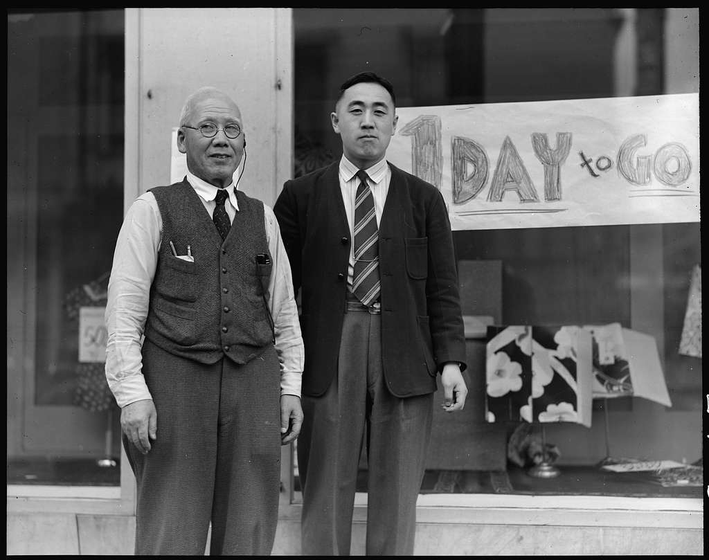
    <summary type="html"><![CDATA[<p><strong><em><span style="font-weight:400;">Dave Tatsuno was one of 11,000 Japanese and Japanese-Americans that were held in Topaz Internment Camp in Delta, Utah. His experience was unique in that he recorded some of his family’s experiences through a motion picture camera that he smuggled into camp. While never intended to be a documentary, his compiled film has since been added to the Library of Congress and further brings to light the conditions experienced by the Japanese in Topaz. </span></em></strong></p><img src="https://www.intermountainhistories.org/files/fullsize/152ee8719f930d9151064c1c1657e3d6.jpg" alt="Dave Tatsuno and his father, merchants of Japanese ancestry in San Francisco prior to evacuation " /><br/><p><span style="font-weight:400;">Born Masaharu Tatsuno in Japan in 1913, Tatsuno immigrated to the United States with his parents when he was only a few months old. Upon arrival in the Bay Area, and due to a clerical error that not even his family understands, he was given a U.S. birth certificate. At a young age, his mother abandoned his family and returned to Japan, leading him to become heavily involved in the YMCA. He decided to adopt the name “Dave” while in junior high. He married Alice Okada in 1938, and their first son, Sheldon, was born in 1940. Amateur filmmaking became a passionate hobby of his after the death of a close friend, when he realized that film had the potential to metaphorically “bring someone back to life.” </span>
<span style="font-weight:400;">Due to the Japanese attack on Pearl Harbor in 1941 (in addition to other Japanese imperialist activities) and racist attitudes towards the Japanese, President Franklin D. Roosevelt issued Executive Order 9066 in February 1942. This order divided the West Coast into military zones and gave the army authority to relocate civilians further inland. The Japanese were the main group affected by the order. Prior to evacuation and internment, Tatsuno helped his father, Shojiro, operate a dry goods store in the Bay area called “Nichi Bei Bussan.” In order to prepare to move, “Nichi Bei Bussan” had an evacuation day sale, where they were forced to sell their goods at incredibly low prices in order to get rid of inventory quickly. </span>
<span style="font-weight:400;">Tatsuno and his family were first held at Tanforan Racetrack and later relocated to Topaz in 1942. Tatsuno, who was familiar with running a business, became one of the managers of the co-op store in camp. While working, he met Walter Honderick, a War Relocation Authority official who owned a camera himself. Honderick encouraged Tatsuno to send for his camera under Honderick’s name. Tatsuno, while on a trip for supplies for the co-op, purchased film for the camera in Chicago. With camera and film, Tatsuno was able to participate in his old hobby again.</span>
<span style="font-weight:400;">In interviews, Tatsuno was adamant that his film in Topaz was never meant to be a documentary. Its focus was specifically on his family and friends. Despite that, the film does contain significant and telling scenes. One scene depicts several Japanese men digging a trench outside one of the barracks. Tatsuno’s narration (which was added to the film much later) relates that the men were repairing a broken pipe. This scene depicts the labor that the Japanese were expected to contribute in order to keep the camp running. Another scene, perhaps one of the most significant, shows Tatsuno’s brother, Masateru (or “Tut”) visiting the camp as an American soldier on his way to Germany. In later interviews, Tatsuno described that he found great irony and injustice in the fact that his brother, especially with his position as a U.S. soldier, had to visit his family behind barbed wire. </span>
<span style="font-weight:400;">Tatsuno and his family returned to the Bay Area in 1945, where they reopened “Nichi Bei Bussan” and sought to help other Japanese returning from internment camps transition back to everyday life. Tatsuno continued to serve as part of the Japanese American Citizens League (JACL) and the YMCA throughout the rest of his life. His film </span><i><span style="font-weight:400;">Topaz</span></i><span style="font-weight:400;"> was added to the Library of Congress in 1996. Tatsuno passed away in 2006, but his legacy of recording his experience at Topaz remains. </span></p><p><em><strong><a href="https://www.intermountainhistories.org/items/show/775">For more (including 3 images) view the original article</a></strong></em></p>]]></summary>
    <published>2024-01-23T05:03:04+00:00</published>
    <updated>2026-04-17T19:32:17+00:00</updated>
    <link rel="alternate" type="text/html" href="https://www.intermountainhistories.org/items/show/775"/>
    <id>https://www.intermountainhistories.org/items/show/775</id>
    <author>
      <name>Sara Davis, Brigham Young University</name>
    </author>
  </entry>
  <entry>
    <title type="html"><![CDATA[David O. McKay Building (MCKB)]]></title>
    <summary type="html"><![CDATA[<p><strong><em>Built in 1954, the David O. McKay Building houses Brigham Young University’s School of Education, which includes Educational Leadership, Elementary and Secondary Education, and Psychology and Instructional Sciences. </em></strong></p><img src="https://www.intermountainhistories.org/files/fullsize/04d52dc247059a5d95ebd8431a5a7dfe.jpg" alt="A Model of the David O. McKay Building" /><br/><p><span style="font-weight:400;">The David O. McKay Building, dedicated in 1954, was originally named the Church Teachers College. Since its construction, the building has gone through various renovations and name changes before achieving its current status. Today, it houses one of the largest Education Preparation Programs in the United States and offers 15 degrees, employs 87 faculty members, and has served over 50 thousand living alumni. </span>
<span style="font-weight:400;">The David O. McKay Building honors the ninth president of the Church of Jesus Christ of Latter-Day Saints, David O. McKay, who was a lifelong educator. Throughout his life, McKay honored the School of Education's mission: provide a rigorous, gospel-centered education while learning after the Master Teacher, Jesus Christ. David O. McKay emphasized the importance of providing all young people with an equal opportunity to gain an education. His vision of schooling went beyond the common school movement of the twentieth century. He believed in creating experiences for children to learn and refine their character. </span>
<span style="font-weight:400;">The David O. McKay Building commemorates his distinctive contribution to the Education profession and his quest to find and employ truth in teaching. One of BYU's core aims is to be a lifelong learner and the David O. McKay Building reflects it. </span></p><p><em><strong><a href="https://www.intermountainhistories.org/items/show/651">For more (including 3 images) view the original article</a></strong></em></p>]]></summary>
    <published>2022-09-14T20:55:26+00:00</published>
    <updated>2026-04-17T19:32:14+00:00</updated>
    <link rel="alternate" type="text/html" href="https://www.intermountainhistories.org/items/show/651"/>
    <id>https://www.intermountainhistories.org/items/show/651</id>
    <author>
      <name>Olivia Forsberg, Brigham Young University</name>
    </author>
  </entry>
  <entry>
    <title type="html"><![CDATA[Ephraim Pioneer Cemetery]]></title>
    <summary type="html"><![CDATA[<p><strong><em>Ephraim’s forgotten cemetery stands as a memorial to early Scandinavian settlers and a reminder of violence in pioneer-era Utah.  </em></strong></p><img src="https://www.intermountainhistories.org/files/fullsize/0a0ea5bdb78a58b830875ad874dbde59.jpg" alt="View of Ephraim Pioneer Cemetery Facing East" /><br/><p>The events that led to the creation of Ephraim Pioneer Cemetery reflect the tumult of early Euro-American settlement in Utah. Members of The Church of Jesus Christ of Latter-day Saints established Fort Ephraim in 1854 near, the geographic center of Utah. These first settlers in Ephraim were far from their homelands; most were converts to the Church who had immigrated from Denmark. Consequently, the settlement became known as “Little Denmark.” When Chief Wakara met Brigham Young in 1849 he invited Latter-day Saints to settle in Central Utah, but amicable relations between Euro-American settlers and the indigenous peoples of the region did not last for long. The Walker War fought between Euro-American Latter-day Saints and Utes brought violence to the Ephraim region from 1853 to 1854, just as Fort Ephraim was being built. The first person from Fort Ephraim to die was a Mr. Manwaring, though the details surrounding his death are unknown. The fort was small and did not have a cemetery in the plans, so the settlers received permission to bury Manwaring in Spring City, ten miles to the north. When the funeral party was just two miles out of Ephraim there came word of an imminent attack. Stuck vulnerably between the two settlements, the settlers went no farther but quickly buried Mr. Manwaring’s body and returned to the safety of the fort. These unexpected circumstances determined where Ephraim residents would be buried until 1905, when residents began using the Park Cemetery in town.
Ephraim Pioneer Cemetery hosts the graves of various inhabitants whose diverse occupations were useful to Fort Ephraim’s functions. They were masons, blacksmiths, stonecutters, millers, harness makers, shingle makers and more. Nearly all the names on the cemetery’s headstones end in the Scandinavian “son” or “sen.” Where a place of birth was added, it nearly always indicates Denmark and occasionally Sweden. The history of violence in the area is also etched on the cemetery’s headstones. For example, the marker for Christian Thorpe indicates he was a second lieutenant in the Blackhawk War, fought between the United States and Sauk leader Black Hawk. Additionally, a granite stone marks the burial site of seven individuals who were killed in 1865. Other cemetery residents were victims of drowning, and disease was also a prevalent threat, as evidenced by the many children’s graves. The cemetery acts as a reminder of the many risks early pioneers faced in Utah.
Approaching Ephraim from the north, it is easy to miss the small clump of trees marking the cemetery off in the distance west of the highway. The cemetery is more than a mile out of town and is accessible only by a dirt road.  The cemetery has gone through periods of neglect and renewal through the decades. In 1990, a committee organized to transform the derelict cemetery to a more respectful resting place. In 1995, the Daughters of Utah Pioneers added plaques to inform visitors about the history of the site. In 2017, a local Boy Scout collected old farm equipment from the mid to late-1800s and placed them in the cemetery as part of an Eagle Scout project. Visitors today will see new, shiny replacement headstones for some alongside broken pieces marking the burial of others.</p><p><em><strong><a href="https://www.intermountainhistories.org/items/show/560">For more (including 6 images) view the original article</a></strong></em></p>]]></summary>
    <published>2021-12-18T04:48:49+00:00</published>
    <updated>2026-04-17T19:32:12+00:00</updated>
    <link rel="alternate" type="text/html" href="https://www.intermountainhistories.org/items/show/560"/>
    <id>https://www.intermountainhistories.org/items/show/560</id>
    <author>
      <name>Tessa Smith, Brigham Young University</name>
    </author>
  </entry>
  <entry>
    <title type="html"><![CDATA[Eureka! Mining and Settlement in the Tintic Mountains]]></title>
    <summary type="html"><![CDATA[<p><strong><em>Eureka, Utah rests within the East Tintic Mountains in northern Juab county. Established in 1870, within the first twenty years of its existence, the Eureka population increased by 1,320.5%. It was the ninth-largest city in Utah in 1910. Though it was a bustling metropolis in the 1920s, Eureka is now one of Utah’s semi-ghost towns.</em></strong></p><img src="https://www.intermountainhistories.org/files/fullsize/c208bab5d88c9df7c90549eb004d8552.jpg" alt="Abandoned building on main street" /><br/><p><p class="Default"><span style="font-weight:400;">Eureka, Utah is a semi-ghost town located within the East Tintic Mountains in northern Juab County. Originally named Ruby Hollow, the town was renamed “Eureka” in 1870 after one of the “Big Four” mines in the area: Bullion Beck and Champion, Gemini, Centennial Eureka, and Eureka Hill. The largest town among a cluster of mining settlements, by 1910 Eureka was the ninth-largest city in Utah with a population of about 3,500 people. About a decade later, in 1922, Eureka’s Chief Consolidated Mining Company became the largest silver producer in the United States. Around the turn of the 20th century, a newspaper described it as “one of the most progressive and prosperous mining towns in this western country.” Despite its economic prosperity through World War I, the mines near Eureka became less productive during the Great Depression. Mining nearly came to an end by the 1950s. In 2019, the US Census Bureau reported that only about 107 people still lived in Eureka.</span>
<p class="Default"><span style="font-weight:400;">Eureka has connections with several illustrious figures in Utah’s history. Eureka was home to the second “Golden Rule” store built in 1909 by James Cash Penney. Expanding his business from this location, Penney developed the J.C. Penney chain of department stores. Jesse Knight, known for financially contributing to Brigham Young University where a campus building bears his name, also has ties to Eureka. Knight invested in the Humbug mine in 1886, and using the profits of his investment, Knight acquired several additional mines in the Tintic Mountains. He built a company town near Eureka called Knightsville, where he built a meetinghouse, school, and amusement building, though the settlement has since become a ghost town. Eureka is also the birthplace of Frank J. Zamboni, the inventor of the Zamboni, a vehicle used to clean and resurface the ice in ice rinks. A building which locals say was the original summer cabin of Porter Rockwell is also found along Eureka’s Main street. Eureka celebrates this history with a western diner named Porter’s Place.</span>
<p class="Default"><span style="font-weight:400;">Although people still live in Eureka, residents maintain its historic, mining town feel. In 1979, Eureka was added to the National Register of Historic Places, and several place markers provide insight into the town’s history. Main Street is full of historic, repurposed, or abandoned buildings. For example, the post office built in 1894 was purchased by the “Everybody’s” merchandising company in 1926. It currently serves as a shop today with products and souvenirs linked to Eureka’s rich history. Multiple historic churches are scattered along Eureka’s Main Street, most built in the Gothic Revival Style. The former Miner’s Union Hall has been repurposed as the Tintic Mining Museum. Some buildings, however, retain their original purposes, such as the Juab County Courthouse which still serves as the County Courthouse and City Jail.</span>
<p class="Default"><span style="font-weight:400;">Eureka is picturesque both in its architecture and in its surrounding landscape. It is a fitting home base for anyone looking to learn about Utah’s mining history, explore its nearby ghost towns such as Knightsville, Homansville, Dividend, or Silver City, or enjoy some of the outdoor scenic wonders that Juab County has to offer.</span></p><p><em><strong><a href="https://www.intermountainhistories.org/items/show/559">For more (including 4 images) view the original article</a></strong></em></p>]]></summary>
    <published>2021-12-18T04:17:31+00:00</published>
    <updated>2026-04-17T19:32:12+00:00</updated>
    <link rel="alternate" type="text/html" href="https://www.intermountainhistories.org/items/show/559"/>
    <id>https://www.intermountainhistories.org/items/show/559</id>
    <author>
      <name>Emily Sabey, Brigham Young University</name>
    </author>
  </entry>
  <entry>
    <title type="html"><![CDATA[Farmington Rock Chapel and the First Latter-day Saint Primary]]></title>
    <summary type="html"><![CDATA[<p><strong><em>Built of rock and gravel, the Farmington Rock Chapel was the birthplace of the Primary Association, a Latter-day Saint church group which has grown to be a significant world-wide children’s organization. The chapel continues to serve as a worship place for Farmington residents today.</em></strong></p><img src="https://www.intermountainhistories.org/files/fullsize/4402dd70afb18b42ed4999a08fbccde0.jpg" alt="Rock Chapel" /><br/><p>The Farmington Rock Chapel has long provided the community of Farmington with a place to worship and to gather. Before its construction, members of The Church of Jesus Christ of Latter-day Saints living in Farmington met for church services in one another’s homes, the schoolhouse, and courthouse, but none were large enough—or appropriate enough in the case of the courthouse—for all to meet in. When a windstorm caused a rockslide which provided enough rocks, sand, and gravel to build a chapel for themselves, Farmington’s Latter-day Saints considered it a miracle. They began construction on the chapel in 1861 and finished in 1863.
The biggest event of general significance in the Rock Chapel was the formation of the Church’s Primary Association, a subunit of the Church dedicated to children’s education and spiritual development, on August 11, 1878 by Aurelia Spencer Rogers, a Farmington resident, and Eliza R. Snow, the general Relief Society President of the Church. They held the first Primary meeting on August 25, 1878 in the Farmington Rock Chapel, where 115 children attended. Rogers felt that forming a children’s organization in the Church was necessary because the children of Farmington had too much unsupervised time. She and Snow founded the Primary Association to teach children lessons on gospel principles, civic and cultural duties, and good manners. The Primary eventually spread to other congregations, and it was adopted churchwide in 1880.
Since the organization of the Primary, the Rock Chapel has been the home of several congregations and the site of events of varying significance. Latter-day Saints continue to worship in the Rock Chapel to this day. The Church added three additional wings to the original in 1941 and 1980. Because of its significance to the residents of Farmington, the chapel was added to the U.S. National Register of Historic Places in October 2011, and tourists can visit the Rock Chapel as part of a historic trail along Farmington’s Main Street.</p><p><em><strong><a href="https://www.intermountainhistories.org/items/show/558">For more (including 4 images) view the original article</a></strong></em></p>]]></summary>
    <published>2021-12-18T03:27:47+00:00</published>
    <updated>2026-04-17T19:32:12+00:00</updated>
    <link rel="alternate" type="text/html" href="https://www.intermountainhistories.org/items/show/558"/>
    <id>https://www.intermountainhistories.org/items/show/558</id>
    <author>
      <name>Brittany Leonard, Brigham Young University</name>
    </author>
  </entry>
  <entry>
    <title type="html"><![CDATA[First Zions Bank]]></title>
    <summary type="html"><![CDATA[<img src="https://www.intermountainhistories.org/files/fullsize/ef9008287dbad34b0b647d4a80b6f211.jpg" alt="Original Eagle Emporium Building and Clock" /><br/><p><span style="font-weight:400;">Zion’s Savings Bank and Trust Company was incorporated under the laws of the Utah Territory under the direction of Brigham Young. On July 10, 1873, it became Utah's first chartered savings bank and trust company. Zion’s Savings Bank and Trust Company grew over the decades, enduring the economic booms and busts including the Great Depression.</span>
</p><p><span style="font-weight:400;">On Dec. 31, 1957, Zion’s Savings Bank and Trust Company, Utah Savings and Trust Company, and First National Bank of Salt Lake City merged to form Zions First National Bank. This merger brought each of these institutions under the management of the LDS church and brought an end to the apostrophe in its name. In early 1960, authorities of The Church of Jesus Christ of Latter-day Saints decided to relieve itself of its banking interests, and on April 22, 1960, the church sold majority control of Zions First National Bank</span>
</p><p><span style="font-weight:400;">The Salt Lake City office on Main Street and the iconic clock just outside are both historically significant. They represent original architecture from early LDS settlements. The building is called the “Eagle Emporium Building” and is the oldest existing commercial building in downtown Salt Lake City. It is the city’s only remaining commercial structure built prior to the completion of the transcontinental railroad. The Eagle Emporium Building was constructed for William Jennings, Utah’s first millionaire, and was originally used to house his mercantile business. Originally powered by a water wheel, the clock was erected on the building in 1873. The clock is one of the few remaining pieces of 19th-century street furniture in downtown Salt Lake. At the request of Brigham Young, the building became the first home of Zion’s Savings Bank and Trust Company. </span>
</p><p><span style="font-weight:400;">Zions Bank continues to bring value to individuals, small-to middle-market businesses, nonprofits, corporations and institutions through a wide range of traditional banking and innovative technology services. It currently has a network of 122 full-service financial centers across Utah, Idaho, and Wyoming. </span></p><p><em><strong><a href="https://www.intermountainhistories.org/items/show/653">For more (including 4 images) view the original article</a></strong></em></p>]]></summary>
    <published>2022-09-16T16:53:09+00:00</published>
    <updated>2026-04-17T19:32:14+00:00</updated>
    <link rel="alternate" type="text/html" href="https://www.intermountainhistories.org/items/show/653"/>
    <id>https://www.intermountainhistories.org/items/show/653</id>
    <author>
      <name>Michael M. Heaton, Brigham Young University</name>
    </author>
  </entry>
  <entry>
    <title type="html"><![CDATA[Founding of the Utah People’s Party]]></title>
    <summary type="html"><![CDATA[<p><strong><em><span style="font-weight:400;">19th-century tensions between members of the Church of Jesus Christ of Latter-day Saints and opponents of the church in Utah led to the creation of two political parties in 1870, the People’s Party and the Liberal Party. The founding of these parties was controversial in that members of the Church flooded their opponents’ meeting in order to form their own party. </span></em></strong></p><img src="https://www.intermountainhistories.org/files/fullsize/59e45fffcfef628985ad3c07fba0226b.jpg" alt="William Godbe" /><br/><p><span style="font-weight:400;">In 1870, tension between the members of the Church of Jesus Christ of Latter-day Saints and non-members living in Utah was high. Church members voted as a block, which made it nearly impossible for non-members of the church to find a voice in government through traditional democratic means. </span>
<span style="font-weight:400;">The foundation of what some called the New Movement, or the Godbeites aggravated the tensions. The Godbeites were former members of the LDS Church, newfound spiritualists, and reformists. They were a unique splinter group within the Church who wanted to reform the Church rather than destroy it, as many of its enemies hoped to do. The Godbeites preached education and reform to Utah’s LDS and non-LDS residents as well as to the federal officials in the state. </span>
<span style="font-weight:400;">The Godbeites gained little traction against the the Church of Jesus Christ of Latter-day Saints, which maintained a large majority of the population in Utah, but it did capture the attention of non-members who sought to create a coalition to counter church political dominance. Godbeites joined non-member businessmen, miners, and others unaffiliated with the Church, bound by little other than their goal of disrupting the dominance of the Church of Jesus Christ in political matters. </span>
<span style="font-weight:400;">On the evening of February 10, 1870, the Godbeites and their partners gathered at the Walker Dry Goods Store on the corner of 3rd South and Main Street in Salt Lake City, Utah. The Godbeites and their new allies intended to form a new political party—one for the “People” as they advertised it. Church members caught word. Editors of the Deseret News and other church leaders organized a protest. Many members showed up at the meeting and managed to get in the doors before anyone else. They occupied all the seats, elected their own candidates, and formed a new party, calling themselves the “People’s Party” as a tongue-in-cheek reference to the Godbeites earlier advertisements. </span>
<span style="font-weight:400;">After their peaceful protest, the Saints left and the non-members organized the “Liberal Party.” One member of the new party remarked that the move by LDS leaders to flood their meeting was the “cleverest thing.” Luckily, the event did not devolve into violence, but the tension between these two parties would continue for their two decades of existence. Newspapers as far away as Sacramento, California wrote about the tension, predicting incorrectly that conflict between the competing factions spelled “impending doom.”</span></p><p><em><strong><a href="https://www.intermountainhistories.org/items/show/788">For more (including 4 images) view the original article</a></strong></em></p>]]></summary>
    <published>2024-03-02T01:46:51+00:00</published>
    <updated>2026-04-17T19:32:17+00:00</updated>
    <link rel="alternate" type="text/html" href="https://www.intermountainhistories.org/items/show/788"/>
    <id>https://www.intermountainhistories.org/items/show/788</id>
    <author>
      <name>Elle Morgan, Brigham Young University</name>
    </author>
  </entry>
  <entry>
    <title type="html"><![CDATA[Galena–Soo’nkahni Preserve &amp; Sundial ]]></title>
    <summary type="html"><![CDATA[<p><strong><em>Along the banks of the Jordan River there is a 252-acre preserve that protects ancient artifacts and lands of tribes that once inhabited the area. Within the preserve is a monument, designed as a natural sundial, that honors all of Utah’s Native American tribes. </em></strong></p><img src="https://www.intermountainhistories.org/files/fullsize/8be27fa24032daf27fa7e33649d058c4.jpg" alt="Galena Soo’nkahni Preserve" /><br/><p>During a land survey conducted in 1991, remnants of an ancient Native American village were found in the Draper, Utah area along the Jordan River.  Stone tools, weapons, corn, animal bones, and the remains of two ancient dwellings were discovered in the area, some of which dated back to Archaic Period between 800 and 480 BC. The artifacts suggest those living in the 3,000-year-old village were corn farmers. Archeologists believe this is one of the earliest known locations of corn farming in the Great Basin.
In 2009, 252 acres were set aside to preserve and protect the wetland and wildlife in the area as well as conserve its cultural heritage. Jason Walker, chairman of the Northwestern Band of Shoshone, described said his ancestors roamed the area and described the land as sacred. The preserve was named Galena Soo’nkahni, which is Shoshone for “many dwellings.” It is protected by Utah Open Lands and managed by the Utah Department of Forestry, Fire and State Lands.
To pay homage to the former inhabitants of the area, as well as all Native American tribes in Utah, the the state’s eight indigenous tribes and the Utah Division of Indian Affairs partnered to create a memorial was constructed in the preserve, which they dedicated in March 2015. Utah Transit Authority, who had planned to build a FrontRunner station on the preserve before it was protected in 2009, donated money for the monument to demonstrate their commitment to recognizing cultural landmarks. The memorial is a natural sundial, with 8 posts for each of the Utah tribes: Skull Valley Band of Goshute, Northwestern Band of the Shoshone Nation, Ute Indian Tribe, Navajo Nation, Ute Mountain Ute Tribe, San Juan Southern Paiute Tribe, Paiute Indian Tribe, and Confederated Tribes of the Goshute Reservation. Each post has information on a tribe and sits in the direction that best matches the tribe’s location in Utah.
The monument and preserve hold deep significance for many Native Americans today as it honors their ancestors and provides an opportunity for others to learn about Utah’s tribes. At the monument’s dedication, Shirley Silversmith, director of the Utah Division of Indian Affairs, said, “We don’t want them to be forgotten,” she said. “We have to have a way to remember that our ancestors lived here.”</p><p><em><strong><a href="https://www.intermountainhistories.org/items/show/557">For more (including 3 images) view the original article</a></strong></em></p>]]></summary>
    <published>2021-12-18T02:57:25+00:00</published>
    <updated>2026-04-17T19:32:12+00:00</updated>
    <link rel="alternate" type="text/html" href="https://www.intermountainhistories.org/items/show/557"/>
    <id>https://www.intermountainhistories.org/items/show/557</id>
    <author>
      <name>Bethany Erickson, Brigham Young University</name>
    </author>
  </entry>
  <entry>
    <title type="html"><![CDATA[George Edward Anderson Photographs]]></title>
    <summary type="html"><![CDATA[<p><strong><em><span style="font-weight:400;">George Edward Anderson is known for pioneering early 20</span><span style="font-weight:400;">th</span><span style="font-weight:400;"> century photography in Utah. His collection shows what was important to Utahns, particularly to members of the Church of Jesus Christ of Latter Day Saints.</span></em></strong></p><img src="https://www.intermountainhistories.org/files/fullsize/718d4ca9986add3c0b25a832b99c478b.jpg" alt="George Edward Anderson" /><br/><p><span style="font-weight:400;">George Edward Anderson was born on October 28, 1860 to parents George Anderson and </span><span style="font-weight:400;">Mary Ann Anderson in Salt Lake City. He was raised a member of the Church of Jesus Christ of Latter Day Saints. As a boy he was apprenticed to Charles R. Savage, a pioneer in photography in Utah, and set up his own studio at the age of 17. In 1886, he established the <em>Temple Bazar </em>studio in Manti, and in 1888 moved it to Springville to the southwest corner of Main and 3rd South Streets. He also operated traveling tent studios.</p><span style="font-weight:400;">Early in his career he took many studio photographs of prominent and everyday Utahns. Later he began to travel and take photographs of significant historical LDS sites. However, his travels took a toll on his relationship with his wife, Olive Lowry Anderson, so he remained home for a period. However his church commissioned him to document new temple dedications in photography. Before going to what would be his last photo shoot, his wife urged him to stay home. He ignored her warning, traveling to the Mesa Arizona Temple dedication. Shortly after the ceremony, he suffered heart failure and died on May 9, 1928 after being transported home. In his obituary the Salt Lake Telegram recounted his accomplishments in photography: “he established a studio at Springville and also had studios at Spanish Fork and Manti... He devoted considerable time to a collection of L.D.S. church historical pictures.”</span>
<span style="font-weight:400;">After Anderson’s death, his collection of photographs changed hands many times. The significance of his images were apparent to many different groups, particularly the Church of Jesus Christ of Latter-Day Saints. A group of LDS seminary teachers in Provo bought Anderson’s collection from his wife in 1928, the year he died. Later Church Historians became aware of the collection and bought it from the seminary teachers. Representatives of the Church of Jesus Christ of Latter Day Saints worked to gather all of the negatives from Anderson’s collection and brought all of his photographs into one collection. After digitizing these negatives, the Church destroyed all but 444 of the glass negatives from the collection. Finally, the collection found a home in the L. Tom Perry Special Collections at Brigham Young University.</span></p><p><em><strong><a href="https://www.intermountainhistories.org/items/show/776">For more (including 6 images) view the original article</a></strong></em></p>]]></summary>
    <published>2024-01-25T05:07:20+00:00</published>
    <updated>2026-04-17T19:32:17+00:00</updated>
    <link rel="alternate" type="text/html" href="https://www.intermountainhistories.org/items/show/776"/>
    <id>https://www.intermountainhistories.org/items/show/776</id>
    <author>
      <name>Starrla Kay Pearson, Brigham Young University</name>
    </author>
  </entry>
  <entry>
    <title type="html"><![CDATA[Grandstaff Canyon: A Beautiful Place with a Complicated Naming History]]></title>
    <summary type="html"><![CDATA[<p><strong><em>Grandstaff Canyon was renamed in 2017 due to its controversial name. Previously  known as Negro Bill Canyon since the 1940’s, this historical location provides a rich  history and provokes deep thought into how that history should be portrayed. </em></strong></p><img src="https://www.intermountainhistories.org/files/fullsize/a6af9c137339bb03665ba3a182d5f9d3.jpg" alt="Walking trail through Grandstaff Canyon" /><br/><p><span style="font-weight:400;">Beginning in the 1940’s, Negro Bill Canyon was an official place on the map, located just outside of Moab, Utah. The canyon was named after William Grandstaff. For the  past 20 years, questions have surrounded its controversial name and whether it should be changed out of respect for William Grandstaff or kept in order to maintain history. Ultimately, a federal board voted to change the canyon's name to Grandstaff Canyon in 2017. </span>
<span style="font-weight:400;">William Grandstaff’s life was a bit of a mystery, although some basic facts are known. In the 1830s, William Grandstaff was born into slavery in Shenandoah County, Virginia. During the first 30-40 years of his life, Grandstaff made his way across the country. After a stop in Cincinnati, Ohio, where Grandstaff fought in the Black Brigade of Cincinnati during the Civil War, he made it to the Moab area in 1877. Grandstaff first resided in an abandoned LDS fort that had been constructed during a period of conflict between the settlers and local Utes. Grandstaff was a frontiersman and one of the first non-native settlers in the area. His presence in Moab helped to promote settlement in the area.  </span>
<span style="font-weight:400;">Grandstaff ranched, grew crops, and had a large herd of cattle. Due to the stream and trees that provided shade, the canyon was perfect for agriculture and ranching. Local Indigenous people visited the canyon to trade with Grandstaff. Today, this area is used as a beautiful recreational area for local hikers and visitors to explore. By changing the name  of the canyon, its visitors can now hold deeper respect, appreciation, and curiosity for William Grandstaff, one whose legacy is still remembered by the people of Moab.</span></p><p><em><strong><a href="https://www.intermountainhistories.org/items/show/650">For more (including 4 images) view the original article</a></strong></em></p>]]></summary>
    <published>2022-09-14T18:50:03+00:00</published>
    <updated>2026-04-17T19:32:14+00:00</updated>
    <link rel="alternate" type="text/html" href="https://www.intermountainhistories.org/items/show/650"/>
    <id>https://www.intermountainhistories.org/items/show/650</id>
    <author>
      <name>Addison Ashby, Brigham Young University</name>
    </author>
  </entry>
  <entry>
    <title type="html"><![CDATA[Heart of Polyurethane: Barney Clark and the Artificial Heart]]></title>
    <summary type="html"><![CDATA[<p><strong><em>In December 1982, Dr. Barney B. Clark received the first permanent total artificial heart implant in a human. The implant was his last resort and his last chance of survival after being diagnosed with congestive heart failure in 1979. He lived with the Jarvik-7 artificial heart for 112 days. Today a memorial in Provo honors his courage.</p></strong></p><img src="https://www.intermountainhistories.org/files/fullsize/1687587c565e27f65f087d15a77083a3.jpg" alt="Marker Close Up" /><br/><p><span style="font-weight:400;">In December 1982, Dr. Barney Clark pioneered medical research by receiving the first artificial heart implant. Clark had suffered from congestive heart failure for several years and his condition was worsening. Despite the experimental nature of the implant and the potential for significant personal suffering, Clark wanted to receive the artificial heart. It represented his last remaining option for survival, and he aimed to contribute to the medical community’s knowledge in the field of heart disease. Before the surgery, Clark had been treated by several doctors. He tried many treatments including experimental medications. Because of the limited number of heart donors, he was too old and too sick to be eligible for an organic heart transplant. The Jarvik-7 artificial heart was his last resort. </span>
<span style="font-weight:400;">The artificial heart was heavily researched before Clark received it. Dr. William C. DeVries had been researching it since 1967. DeVries had implanted the Jarvik-7 heart in cadavers and in many live animals, including calves. Every detail of the preparation and the surgery were outlined almost two years before Clark was selected to receive the implant. </span>
<span style="font-weight:400;">The implant surgery was initially successful. On Thursday, December 2, 1982 the Provo Daily Herald reported that after seven hours of surgery the artificial heart was working well and that it had given Clark “the blood pressure of an 18-year-old.” Despite the successful surgery, Clark soon started facing complications. He experienced an air leak in his lung, seizures, a broken valve on the artificial heart, and frequent nose bleeds. The doctors fixed these problems as they arose, although they were never able to figure out the cause of the seizures. In March 1983 Clark suffered from aspiration pneumonia, which sent him back into the intensive care unit. He never recovered. On March 23, 1983 Clark “suffered from multiple organ system failure that caused a circulatory collapse” and passed away at 10:02 that night. Researchers concluded that the artificial heart itself had not killed him, but complications associated with the surgery and prior conditions had. </span>
<span style="font-weight:400;">Clark survived with the Jarvik-7 total artificial heart for 112 days, though experiencing great suffering. Many regard Barney Clark as a pioneer and a hero. A memorial in Provo honors his legacy. Today the artificial heart is used as a temporary placement while heart failure patients wait for a heart donor.</span></p><p><em><strong><a href="https://www.intermountainhistories.org/items/show/768">For more (including 2 images) view the original article</a></strong></em></p>]]></summary>
    <published>2024-01-20T07:16:05+00:00</published>
    <updated>2026-04-17T19:32:17+00:00</updated>
    <link rel="alternate" type="text/html" href="https://www.intermountainhistories.org/items/show/768"/>
    <id>https://www.intermountainhistories.org/items/show/768</id>
    <author>
      <name>Caitlin Zollinger, Brigham Young University</name>
    </author>
  </entry>
  <entry>
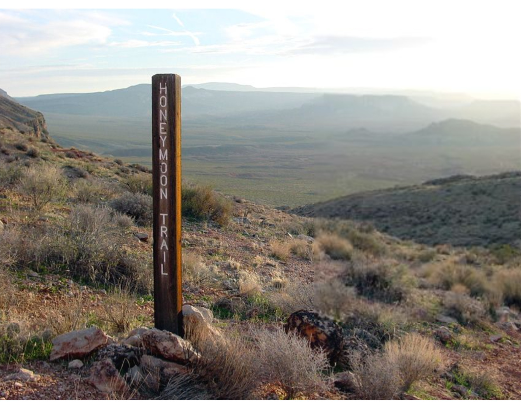
    <title type="html"><![CDATA[Honeymoon Trail]]></title>
    <summary type="html"><![CDATA[<p><strong><em>The Honeymoon Trail connected Latter-day Saint communities in Arizona to St. George and was originally known as the Mormon Wagon Road. Will C. Barnes, an American historian, coined the term Honeymoon Trail as he studied the hundreds of couples who trekked along the trail to the St. George Temple to get married. Couples continued to make the hazardous journey until 1927, when the Mesa, Arizona temple opened. </em></strong></p><img src="https://www.intermountainhistories.org/files/fullsize/b5f9fbc2448e80d9a7874c071208e8c7.jpg" alt="Honeymoon Trail" /><br/><p><span style="font-weight:400;">In 1871, leaders of the Church of Jesus Christ of Latter-Day Saints announced that a temple would be built in St. George in 1871. While this was exciting for members in southern Utah, it was also exciting to the members scattered throughout Arizona who wanted to be married for eternity in a ceremony that could only take place in a temple. After the temple in St. George was completed in 1877, couples in Arizona traveled to St. George to participate in the marriage ceremony. Depending on their starting point in northern or southern Arizona, some couples traveled over 400 miles to be married.</span>
<span style="font-weight:400;">The Honeymoon Trail was difficult to traverse under the best conditions and was sometimes made worse by the weather. Couples had no choice but to cross deep muddy washes and traverse canyons and hills. They could choose between a shorter route across mountains or avoid them by extending their journey by many miles. Although the trail did have a hazardous river crossing, most of the trail lacked adequate drinking water. It was common for oxen to die from dehydration. Some couples made the most of this loss by trading dying or dead oxen to people along the trail for other needed goods. Some couples endured snowstorms while others endured sandstorms. For instance, Joseph Fish, who undertook the trail to marry Julia Reidheid, suffered vision loss due to the sandstorms encountered on the journey. Despite their father’s challenging experience, some of Fish’s children still chose to traverse the same trail to reach the temple, fully aware of the risks they would face.</span>
<span style="font-weight:400;">The physical trail was not the only danger faced by couples. Tensions stemming from the Black Hawk War, a violent confrontation between Latter-Day Saint settlers and the Ute, Paiute, and Navajo nations from 1865 until 1872, led to ongoing confrontations. Some travelers lost horses to Indigenous raiders. However, many of the interactions between travelers and the Natives were friendly. Still, stories of past violence exaggerated the expectations of hostile interactions and caused the travelers to fear. Not only were Natives a concern, but running into strangers and outlaws also brought fear to the lawless wilderness. Danger surrounded the couples and groups who journeyed to the temple in St. George. </span>
<span style="font-weight:400;">The efforts and dedication of the Saints of Arizona were observed by Church leaders. In 1918 they announced that a temple would be built in Mesa Arizona. At the time there were only six operating temples, marking a tremendous victory for the members scattered throughout Arizona. The completion of the Mesa Temple in 1927 brought to an end the colorful history of the Honeymoon Trail.</span></p><p><em><strong><a href="https://www.intermountainhistories.org/items/show/777">For more (including 4 images) view the original article</a></strong></em></p>]]></summary>
    <published>2024-02-02T00:19:57+00:00</published>
    <updated>2026-04-17T19:32:17+00:00</updated>
    <link rel="alternate" type="text/html" href="https://www.intermountainhistories.org/items/show/777"/>
    <id>https://www.intermountainhistories.org/items/show/777</id>
    <author>
      <name>Margie Brown, Brigham Young University</name>
    </author>
  </entry>
  <entry>
    <title type="html"><![CDATA[Indigenous People of Bryce Canyon]]></title>
    <summary type="html"><![CDATA[<p><strong><em><span style="font-weight:400;">The place known today by millions of people as Bryce Canyon National Park has been known by different names to many other people over centuries. The history of those who have journeyed along the canyon before paths were paved there still have a deep connection to the land. And over the past century, an increasing number of people admire the beauty and appreciate such a connection.</span></em></strong></p><img src="https://www.intermountainhistories.org/files/fullsize/83f8b3ce41456cf4cf8fa80c55f1fc6d.jpg" alt="[Untitled]" /><br/><p><span style="font-weight:400;">Unka tumpee wun-nurrx tungwatsini xoopakichu ahnax, Sikyaatutukwi, Bios to chi bi kool, Angka-ku-wass-a-wits, Bryce’s Canyon. </p><p>These are the former names of the geographic marvel now known as Bryce Canyon National Park. Southern Paiutes, Hopi, Zuni, Ute, and Navajo tribes all lived in this region and enjoyed its natural beauty and wonders. Even before these nations, other ancient peoples lived here for centuries. The Indian names, meaning “place of yellow points,” “red painted faces,” and “red rock standing like a man in a hole,” come from ancient legends of the rock formations now called “hoodoos,” meaning scary or a bad omen. Some claimed that the hoodoos were once people who had been turned to stone. This incredible landscape provided a place for indigenous peoples to hunt and gather grass seeds and other foods, creating a deep connection with the land. </span>
<span style="font-weight:400;">Sadly, from 1850 to 1890, through various laws, acts, and atrocities, Native Americans were forced from Bryce Canyon, some to distant reservations. Those that were far removed from Bryce Canyon, like the Navajo, remembered its beauty through oral histories. The Paiutes were not driven out until about 1880, five years after LDS Scottish Rancher Ebenezer Bryce settled there. From the turn of the century onward, new people began coming into the area to settle or sight-see. In 1916, with help from the Union Pacific Railroad, lodges and rest stations began to be built, providing a place for visitors to stay. In 1923, Bryce Canyon became a National Monument and in 1928 it became a National Park, with the boundaries expanded in 1931 and again in 1942. In 1934 workers of the Civilian Conservation Corps created much of the infrastructure that helped make Bryce Canyon more accessible to the public. Today this beautiful National Park is visited by over 1.5 million people annually.</span>
<span style="font-weight:400;">Though this park is now accessible to many people, the indigenous nations that once lived there still have a great connection to the land through their histories and traditions. In past decades most members of those nations lack the resources needed to visit Bryce Canyon, though more indigenous people are able to visit these sacred sites today. They continue to pass on the traditions and stories to new generations. Some Paiutes have returned to the area and still live nearby. Dozens of people currently reside within Bryce Canyon's lands. Leigh Kuwanwisiwma, a member of the Hopi Tribe, teaches “This is our heaven. This is the human people’s heaven, and we need to appreciate that.” A sacred place to many tribes, and now a nationally protected park, Bryce Canyon deserves respect and reverence as visitors admire its wonders.</span></p><p><em><strong><a href="https://www.intermountainhistories.org/items/show/787">For more (including 3 images) view the original article</a></strong></em></p>]]></summary>
    <published>2024-03-01T23:35:49+00:00</published>
    <updated>2026-04-17T19:32:17+00:00</updated>
    <link rel="alternate" type="text/html" href="https://www.intermountainhistories.org/items/show/787"/>
    <id>https://www.intermountainhistories.org/items/show/787</id>
    <author>
      <name>Rachel Feilbach, Brigham Young University</name>
    </author>
  </entry>
  <entry>
    <title type="html"><![CDATA[John Jarvie’s Historic Ranch]]></title>
    <summary type="html"><![CDATA[<p><strong><em>Not all hospitality is returned in kind. In the case of John Jarvie, the outlaws to whom he was so obliging went on to rob and murder both him and his son. </p></strong></p><img src="https://www.intermountainhistories.org/files/fullsize/fa571c3f7ee8336879f9a9d505c7f737.jpg" alt="John Jarvie" /><br/><p><span style="font-weight:400;">In 1880 John Jarvie and his wife Nellie Barr moved from Rock Springs, Wyoming to the burgeoning settlement of Brown’s Park. Jarvie set up a general store, post office, and ran a river ferry that crossed the nearby Green River. Jarvie became well known for his sagacity and kindness to all those who lived in the region, even the Wild Bunch outlaws. Such associations did not serve him well in the long run, but his kindness did, and his legacy has continued to today in Uintah and Daggett County.</span>
<span style="font-weight:400;">John Jarvie was born in Scotland in 1844. As a young man after being beaten soundly by a mine supervisor, Jarvie elected to immigrate to the United States as a stowaway. He arrived in America in 1870 and settled in Rock Springs, Wyoming.  After several years as a businessman in Rock Springs, working as a Saloon Owner, Jarvie met residency requirements and became a citizen on October 8</span><span style="font-weight:400;">th</span><span style="font-weight:400;">, 1875. In 1880 at the age of 36, Jarvie married Nellie Barr, 22, and the couple moved to Brown’s Park, the present location of John Jarvie’s Historic Ranch.  Jarvie opened a general store, moved the local post office to his property, and ran a ferry that crossed the Green River.</span>
<span style="font-weight:400;">Jarvie sold to everyone in the region, even notorious outlaws. One location on the historic ranch in particular, a storage cellar, was thought to have housed criminals like Butch Cassidy when they were on the run from the law. One notable event on the Ranch in 1895 termed the “Outlaws’ Thanksgiving Dinner” saw a dinner of gratitude  between several notorious outlaws including Billie Bender, Les Megs, Butch Cassidy, Elza Lay, Isom Dart, and the Sundance Kid. The meeting was jovial and in celebration of Jarvie and other residents in Brown’s Park tolerance of the outlaw’s activities. In light of their warm relationship, it is tragic that Jarvie and one of his sons eventually lost their lives to outlaws.</span>
<span style="font-weight:400;">William King and George Hood, hearing false rumors about Jarvie’s great wealth, came to the ranch on July 6</span><span style="font-weight:400;">th</span><span style="font-weight:400;">, 1909. Jarvie was alone, his sons having taken jobs on other farms, and his wife having died of Tuberculosis in 1895. Jarvie was known for his generosity and tendency to feed visitors so he set the table for three. The outlaws did not return his kindness. They forced Jarvie to open his store safe and took the contents, a $100 bill and a pearl handled revolver. Jarvie fled the store and was shot in the back and head. The outlaws placed his body on a boat and sent it down the river. Details of the murder slowly tricked out. When reports circulated of two men trying to change a $100 bill in Rock Springs, Jarvie’s son Jimmy pursued the outlaws voraciously. Jimmy was on their trail at an Inn in Idaho when he was pushed from a second-floor balcony and fell to his death. The criminals were never apprehended.</span>
<span style="font-weight:400;">Jarvie left a powerful legacy which was seen in the obituary written for him in the Vernal Express. There he was praised as a “the sage of the Uintahs, the Genius of Brown’s Park, and the Wizzard [sic] of the hills and rivers. He was not only a man among men but he was a friend among men… He was as broad and generous and far reaching in his good deeds as the stream which he knew and loved[.]”</span></p><p><em><strong><a href="https://www.intermountainhistories.org/items/show/770">For more (including 3 images) view the original article</a></strong></em></p>]]></summary>
    <published>2024-01-20T08:08:00+00:00</published>
    <updated>2026-04-17T19:32:17+00:00</updated>
    <link rel="alternate" type="text/html" href="https://www.intermountainhistories.org/items/show/770"/>
    <id>https://www.intermountainhistories.org/items/show/770</id>
    <author>
      <name>Samuel Pulsipher, Brigham Young University</name>
    </author>
  </entry>
  <entry>
    <title type="html"><![CDATA[Joseph F. Smith and the Islanders of Iosepa]]></title>
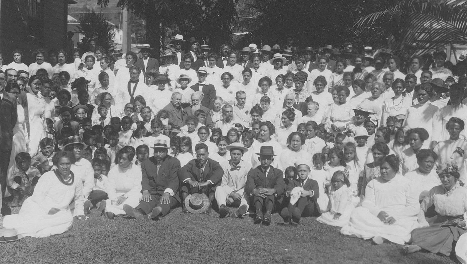
    <summary type="html"><![CDATA[<p><strong><em>The Hawaiian members of the Church of Jesus Christ of Latter-day Saints had a very special relationship with the Church’s sixth president, Joseph F. Smith. He was influential in Hawaiian migrations both to and from Utah, including during the time that many of them resided in Iosepa, a Hawaiian colony.</p></strong></p><img src="https://www.intermountainhistories.org/files/fullsize/c4441ee0af02c1fa09ac1230935470cc.jpg" alt="Joseph F. Smith and Hawaiian Saints" /><br/><p><span style="font-weight:400;">At the age of fifteen, Joseph F. Smith served as a missionary for the Church of Jesus Christ of Latter-day Saints in the Hawaiian Islands in the early 1850s. During his several missions, Smith learned the Hawaiian language and developed a loving relationship with the Native Hawaiians. Throughout his life, Smith traveled to Hawaii more often than any other place outside of the western United States. Smith was successful in converting many Hawaiians to the LDS Church. The doctrine of gathering to “Zion” was a central teaching preached by Joseph F. Smith and other missionaries at that time. When immigration laws allowed it, a few hundred Hawaiian Latter-day Saints migrated to Utah to gather with their fellow Saints and to follow the teachings they had received. The Islanders experienced racism, discrimination, job-turnover, and prejudice that led the LDS Church to seek solutions. In 1889, a settlement was established in Tooele County for the Pacific Islanders settling in Utah. It was to be named after Joseph F. Smith, which in the Hawaiian Language is “Iosepa.” At that time, Smith was a member of the Church’s First Presidency and would later become the President of the Church.</span>
<span style="font-weight:400;">In both public and private correspondence, Joseph F. Smith was explicit in expressing his love for the Iosepan Saints. With a letter to S. M. Kinimakalehua of Iosepa, Smith sent “some cloth pants for the cold time that is coming… This is only rags, but take it with my love.” He reported that “Canon [George Q. Cannon] is joining with my family and I in sending a lot of our love to you and Makaweli and all of the Saints in Iosepa.” During a visit to Hawaii in 1915, Smith became convinced of the need for a temple in Hawaii. Upon returning to Utah, he encouraged the Hawaiian Saints to move back to Hawaii and help build a temple in La’ie. Smith also thought that the future Church Presidents would not have the same love for the Hawaiians that he did, which influenced his encouragement of the Islanders to return to their homeland. The Saints trusted in the council of Joseph F. Smith, and most resettled near the temple site in Hawaii. The settlement of Iosepa was fully abandoned by 1917. In November of 1918, Joseph F. Smith passed away and one year later the La’ie Temple was completed. </span></p><p><em><strong><a href="https://www.intermountainhistories.org/items/show/780">For more (including 4 images) view the original article</a></strong></em></p>]]></summary>
    <published>2024-02-24T03:37:50+00:00</published>
    <updated>2026-04-17T19:32:17+00:00</updated>
    <link rel="alternate" type="text/html" href="https://www.intermountainhistories.org/items/show/780"/>
    <id>https://www.intermountainhistories.org/items/show/780</id>
    <author>
      <name>Jordan Castillo, Brigham Young University</name>
    </author>
  </entry>
  <entry>
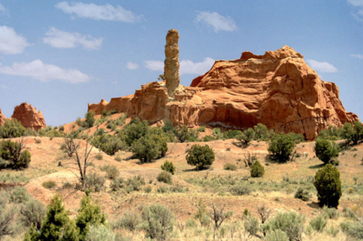
    <title type="html"><![CDATA[Kodachrome Basin and the Power of Photography]]></title>
    <summary type="html"><![CDATA[<p><strong><em>Kodak released its first roll of colored film in 1936 called “Kodachrome.” This film became famous for its new method of producing color in still photography. Its use became widespread among National Geographic photographers, eventually leading to global awareness of the beauty of Southern Utah’s rust colored landscape. </p></strong></p><img src="https://www.intermountainhistories.org/files/fullsize/ef773cd98552f15f18157825eb6cc132.jpg" alt="My Beautiful Picture" /><br/><p><span style="font-weight:400;">In 1948, a group of National Geographic photographers, led by Jack Breed, set out to explore the Southern Utah terrain. Using trails only having ever been passed in modern times by a handful of cattle ranchers, Breed and his crew found a landscape that was relatively untouched. Traveling by car and hiking into more rugged regions, the National Geographic explorers found the contrasting colors of the land to be enchanting. The explorers nicknamed the area “Kodachrome Flat” after the film used to capture the rust colored canyons. Photos taken of the area were later published in a 1949 edition of National Geographic magazine, which had 60 million readers. </span>
<span style="font-weight:400;">Members of the Church of Jesus Christ of Latter-Day Saints who lived in the region were highlighted in the article as well as the landscape. Dressed in pioneer clothing, Breed photographed them recreating a traditional Latter-Day Saint dance in the Kodachrome area, perhaps using the peculiarity to catch readers’ attention. Before the photos were published in the magazine, they were shown to local members of the Lions Club at the Cameron Hotel in Panguitch. Crew member Burnett Hendryx spoke of the National Geographic team’s adventures in the desert. The invitation to view Hendryx’s photos was then extended to the general public who marveled at the color photographs.. This expedition was of great interest to the local residents of Garfield County, not only for the excitement the National Geographic visit sparked in local newspapers, but also because the highly publicized article brought tourists to the county, boosting its isolated economy. </span>
<span style="font-weight:400;">Although originally named Chimney Rock State Park due to copyright issues, the area today is officially known as Kodachrome Basin State Park. It sits in a quiet location between Bryce Canyon and Escalante National Park and is home to a plethora of campsites and hiking trails. It continues to be a tourist site, especially popular among foreigners. The park hosted a total of 179,121 visitors in 2022 and its popularity continues to grow. </span></p><p><em><strong><a href="https://www.intermountainhistories.org/items/show/772">For more (including 3 images) view the original article</a></strong></em></p>]]></summary>
    <published>2024-01-21T22:08:05+00:00</published>
    <updated>2026-04-17T19:32:17+00:00</updated>
    <link rel="alternate" type="text/html" href="https://www.intermountainhistories.org/items/show/772"/>
    <id>https://www.intermountainhistories.org/items/show/772</id>
    <author>
      <name>Jane Carlson, Brigham Young University</name>
    </author>
  </entry>
  <entry>
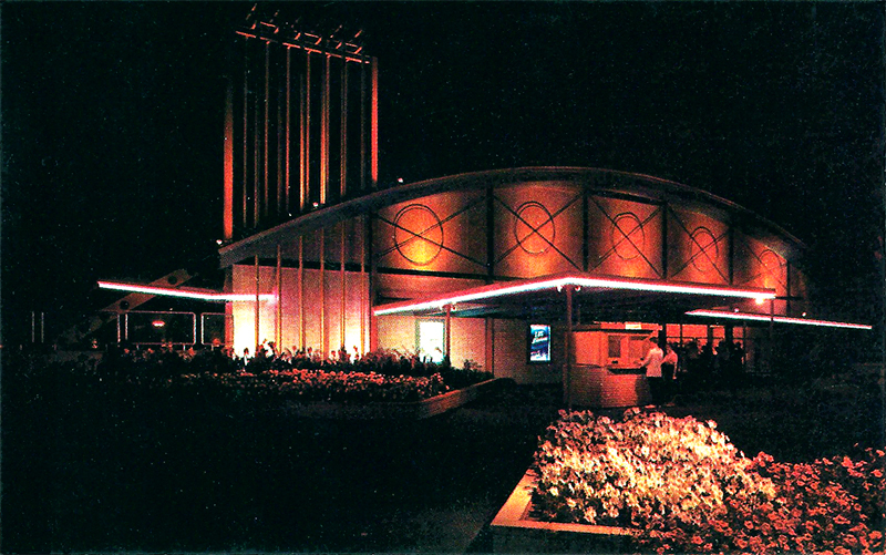
    <title type="html"><![CDATA[Lagoon&#039;s Patio Gardens]]></title>
    <summary type="html"><![CDATA[<p><strong><em><span style="font-weight:400;">Utah’s Lagoon used to be more than just an amusement park; it once housed a large concert venue within its gates, hosting many performances by music legends from the 1950s to the early 1970s.</span></em></strong></p><img src="https://www.intermountainhistories.org/files/fullsize/22bf785d177cfc260f8fabc152cf11d6.jpg" alt="Postcard of Patio Gardens" /><br/><p><span style="font-weight:400;">In 1953 a fire tore throughout Lagoon, Utah’s only amusement park, and destroyed many buildings there. Then owner, Robert Freed, saw this as an opportunity to update the architecture of the park to something much more modern–to create the “New Lagoon.” One of the buildings constructed during the renovations was the Patio Gardens, a concert venue to replace an old, ruined Dancing Pavilion. While Lagoon had live performances before the 1950s, Patio Gardens, with its stage and dance floor, became the new house for concerts. The performances in Patio Gardens over the next two decades included some of the most popular national artists and would make Lagoon nationally known, especially within the 1960s counterculture music scene. </span>
<span style="font-weight:400;">One such popular group was the Beach Boys who, on September 7, 1963, thrilled their youthful Utah audience with their song “Salt Lake City,” claiming that Salt Lake City had “the grooviest kids.” The Beach Boys returned to Lagoon again and again with their final performance of fourteen appearances taking place on September 12, 1970.</span>
<span style="font-weight:400;">The Beach Boys were just one of many popular groups that performed at Patio Gardens. Other notable counterculture bands such as The Rolling Stones, The Monkees, The Who, Janis Joplin, and Jefferson Airplane also performed there. Even The Beatles were in discussions to perform at Lagoon, but their high asking price led to their exclusion. Patio Gardens also housed more classic acts, such as Benny Goodman, the Utah Symphony, and Ella Fitzgerald. </span>
<span style="font-weight:400;">Most bands had a good experience, with some even returning to perform again or immortalizing the venue in songs, as the Beach Boys did. However, there were also bands who hated the venue and, more importantly, the crowds. On May 25, 1968, The Doors performed to a crowd of about 3,500, nearing the venue’s 4,000-person capacity limit. Jim Morrison, the band’s lead singer, declared that the crowd was dead for his first performance of the day, hurled vulgar insults to the audience, and after three songs walked off of the stage, never to return. </span>
<span style="font-weight:400;">Regardless of the failure of The Doors concert, Patio Gardens is remembered fondly by many Utahns. Patio Gardens closed in 1973 after operating for twenty years. Where music legends used to perform is now the home of the dark ride Dracula’s Castle and Lagoon’s arcade. The original light fixtures and the top of the stage (the rest of which is hidden by a wall) are the only reminders of what helped make Lagoon so famous.</span></p><p><em><strong><a href="https://www.intermountainhistories.org/items/show/778">For more (including 3 images) view the original article</a></strong></em></p>]]></summary>
    <published>2024-02-22T22:07:05+00:00</published>
    <updated>2026-04-17T19:32:17+00:00</updated>
    <link rel="alternate" type="text/html" href="https://www.intermountainhistories.org/items/show/778"/>
    <id>https://www.intermountainhistories.org/items/show/778</id>
    <author>
      <name>Mikelle Andersen, Brigham Young University</name>
    </author>
  </entry>
  <entry>
    <title type="html"><![CDATA[Latina Legacies in Carbon County: Latinas in Carbon County]]></title>
    <summary type="html"><![CDATA[<p><strong><em>Despite the difficulties Latinas faced as they settled in coal mining camps, their sacrifices, efforts, and love for their families helped them create culturally welcoming spaces that transformed Carbon County and Notre Dame De Lourdes Church.</em></strong></p><img src="https://www.intermountainhistories.org/files/fullsize/39750120fdd4c704d1a40815308e4861.jpg" alt="Notre Dame de Lourdes Catholic Church" /><br/><p><span style="font-weight:400;">Although Carbon County is known for its cultural diversity, Latinas who resided there often faced discrimination from other groups of immigrants. Angelina Gutierrez recalled “there was so much prejudice against the Spanish people. We could not go anywhere. There [were] about six couples of us [who] went to a bar over here. And they threw us out ‘no Mexicans allowed.’” Rosa Sandoval also remembers the discrimination she faced as a fifth grader by an Italian girl. In addition to facing discrimination, Latinas faced the constant threat of becoming widows and single mothers due to the hazardous working conditions in the mines. When Leticia Ramos’ husband died, she had to assume new responsibilities for the care of her family. She remembers, “[It was] scary because…I didn’t know how to do nothing…I didn’t do nothing but have kids and take care of them.” In situations where their husbands were laid off or passed away because of mine conditions, Latinas became not only caretakers, but breadwinners. They worked in “local hospitals, salons, as secretaries, house cleaners, and cooks.” Even though they were extremely busy, Latinas found refuge in the Catholic Church. </span>
<span style="font-weight:400;">However, Latinas faced challenges even within the refuge of the church. Irish and Italians dominated the Catholic church and as a result Latinas often faced “discrimination and exclusion” there. Latinas did not seclude themselves, but instead claimed their dignity. Patricia Sanchez stated, “we are going to show them that we are people, that we are human. We’re not a little rodent that just goes and hides.” Latinas’ strong stance brought changes to Notre Dame Catholic church. For example, mass started to be held in Spanish. Latinas also formed a church choir where they sang “Alabanzas” in important ceremonies like weddings. Even more revolutionary was the ethnic celebrations incorporated into the church, such as quinceaneras and the Virgin of Guadalupe day. Passing on such traditions was important to Latinas. One of the ways they preserved their culture was by creating fond memories with their children. For instance, Rose remembered spoiling her grandkids with tortillas. In addition, Latinas carved out spaces for their children to learn about their traditions; the Notre Dame Catholic School was such a space. It wasn’t easy paying tuition, but Latinas valued education and they wanted to reinforce their traditional religious values in their kids. As a result of their parents’ sacrifices, Latin children in private school did not face the same type of discrimination they would have faced in public schools. Like the Notre Dame Catholic church, the Notre Dame Catholic school became a place of inclusion and safety for all nationalities thanks to the efforts of Latinas.</span></p><p><em><strong><a href="https://www.intermountainhistories.org/items/show/659">For more (including 3 images) view the original article</a></strong></em></p>]]></summary>
    <published>2022-09-19T20:42:53+00:00</published>
    <updated>2026-04-17T19:32:14+00:00</updated>
    <link rel="alternate" type="text/html" href="https://www.intermountainhistories.org/items/show/659"/>
    <id>https://www.intermountainhistories.org/items/show/659</id>
    <author>
      <name>Sarai Silva, Brigham Young University</name>
    </author>
  </entry>
  <entry>
    <title type="html"><![CDATA[Lehi Sugar Factory: Development of the Sugar Beet Industry in Utah]]></title>
    <summary type="html"><![CDATA[<p><strong><em>Built following a direct revelation from the prophet Wilford Woodruff, the Lehi Sugar factory marked the fulfillment of a multi decade struggle to bring the beet sugar industry to Utah. With its completion came a great economic opportunity for Lehi and its neighboring cities. </em></strong></p><img src="https://www.intermountainhistories.org/files/fullsize/e1ae95f87c9d1611f8c85086382bcddb.jpg" alt="Sugar Cos. Mill, Lehi Utah, 1890" /><br/><p><span style="font-weight:400;">Since the Mormon pioneers arrived in Utah in 1847, Brigham Young, the prophet of the Church of Jesus Christ of Latter-day Saints at the time, was determined to help them become a self-sufficient people and bring industry to Utah. Sugar production was one of the industries at the forefront of church leaders’ minds, because of the vast amount of sugar that had to be imported into the area otherwise. Growing sugar cane was not a viable option because of the arid climate. However, around this time, a method was developed in France allowing sugar to be isolated from beets. Leaders of the church, including John Taylor, were assigned to purchase and move beet sugar processing machinery to the West. Once the machinery arrived, church members tested it to see if it would indeed be able to isolate sugar from beets. The project was a massive failure and the church lost a fortune. </span>
<span style="font-weight:400;">No further attempts were made to produce sugar locally until 1889, when sugar beet production was becoming widespread throughout the United States, and the method of producing sugar from beets was more widely understood. Wilford Woodruff, as current president of the church, received a revelation that the will of the Lord was to have a sugar beet factory built in Utah. In order to raise enough capital for the factory, the church used a large sum of tithing money and borrowed from multiple banks. The Lehi Sugar Factory was built, and Wilford Woodruff opened the ceremony that dedicated the factory to the Lord, a common practice in the Church. </span>
<span style="font-weight:400;">The sugar factory played a large role in the community, contributing greatly to the financial wellbeing of those living in Lehi and others close by. It provided  many jobs working in the factory and an opportunity for farmers to grow crops. The factory continued to operate from 1891 until 1924, when sugar production was relocated to other factories around the state. The factory lot, formerly owned by the Utah and Idaho Sugar Company, was sold in 1979 to a trucking company where it remains in their possession. The smokestack for the factory has since been converted to a cell phone tower, a symbol of the change that has taken place in Utah’s economy over the years.</span></p><p><em><strong><a href="https://www.intermountainhistories.org/items/show/656">For more (including 2 images) view the original article</a></strong></em></p>]]></summary>
    <published>2022-09-16T19:12:33+00:00</published>
    <updated>2026-04-17T19:32:14+00:00</updated>
    <link rel="alternate" type="text/html" href="https://www.intermountainhistories.org/items/show/656"/>
    <id>https://www.intermountainhistories.org/items/show/656</id>
    <author>
      <name>Caleb J. Nokes, Brigham Young University</name>
    </author>
  </entry>
  <entry>
    <title type="html"><![CDATA[Martha Hughes Cannon Memorial Statue]]></title>
    <summary type="html"><![CDATA[<p><strong><em>Martha Hughes Cannon was an outstanding woman with great ambition and intelligence. As she gained an education and grew in the LDS religion, she capitalized on her position as an educated woman of faith to represent Utah women as they battled anti-polygamy legislation and public health issues.</em></strong></p><img src="https://www.intermountainhistories.org/files/fullsize/48b93f901ad49440cfe49a8350fd6fe1.jpg" alt="Martha Hughes Cannon Statue, Provo" /><br/><p>Martha Hughes Cannon was born in Wales on July 1st, 1857. During her infant years, Martha’s parents joined other new converts to the LDS faith on a long journey to Utah. Tragically, her father passed away only three days after arriving in Utah and surviving the arduous westward trek. By her teenage years, Martha had faced considerable hardship and poverty, but showed resilience and hope for the future. Martha’s young adult years were full of education. After graduating college with a degree in chemistry, Martha was accepted into the University of Michigan, one of few medical schools that admitted men and women. She also studied at the National School of Oratory, becoming a skilled public speaker. Her medical skills and oratorical skills would be great assets during her involvement in Utah politics. </p><p>Martha’s personal and professional life gave her a unique position in the eyes of the United States government. As the fourth wife to Angus M. Cannon, Martha faced considerable scrutiny from territorial officials. As a doctor, she delivered many children born to polygamist mothers and was seen as an important witness to prosecute polygamy. She lived out of state for many years to avoid testifying against and incriminating her husband, along with other polygamist families. The official outlawing of polygamy in 1890 allowed Martha to return to Utah and begin her career in politics.</p><p>A request from the Democratic party prompted Martha to run in the state senate election. Although her husband was running for the Republican party, this did not stop Martha from fulfilling what she viewed as an incredible civic opportunity. After winning the Democratic seat, Martha spent four years effectively advocating for public health and education causes in Utah. She authored bills to start the Utah Health Department, and schools for children with disabilities. Unfortunately, Martha’s political career came to an end with her third pregnancy. The nation viewed this as proof that Mormons were still practicing polygamy, and she was now an unacceptable representative. Although her time was cut short, Martha provided many valuable insights to Utah’s state legislature and was a voice for women across the state of Utah.</p><p><em><strong><a href="https://www.intermountainhistories.org/items/show/783">For more (including 3 images) view the original article</a></strong></em></p>]]></summary>
    <published>2024-02-26T19:39:54+00:00</published>
    <updated>2026-04-17T19:32:17+00:00</updated>
    <link rel="alternate" type="text/html" href="https://www.intermountainhistories.org/items/show/783"/>
    <id>https://www.intermountainhistories.org/items/show/783</id>
    <author>
      <name>Olivia Stockman, Brigham Young University</name>
    </author>
  </entry>
</feed>