<?xml version="1.0" encoding="UTF-8"?>
<feed xmlns="http://www.w3.org/2005/Atom">
  <title type="text">Intermountain Histories</title>
  <updated>2026-04-17T19:32:05+00:00</updated>
  <generator uri="http://framework.zend.com" version="1.12.20">Zend_Feed_Writer</generator>
  <link rel="alternate" type="text/html" href="https://www.intermountainhistories.org/"/>
  <link rel="self" type="application/atom+xml" href="https://www.intermountainhistories.org/items/browse?output=rss2"/>
  <id>https://www.intermountainhistories.org/</id>
  <author>
    <name>Intermountain Histories</name>
    <uri>https://www.intermountainhistories.org</uri>
  </author>
  <link rel="hub" href="https://pubsubhubbub.appspot.com/"/>
  <entry>
    <title type="html"><![CDATA[&quot;Roosevelt&#039;s Tree Friends&quot; in Idaho]]></title>
    <summary type="html"><![CDATA[<p><strong><em>Franklin Delano Roosevelt’s 1933-1942 New Deal program, the Civilian Conservation Corps (CCC), provided rural areas and communities with economic stimulus as well as natural resource protection and preservation. While receiving an education and much-needed work, young men who enrolled with the CCC interacted with communities by furnishing isolated regions with recreational areas, accessibility, and protection from forest fire and disease.</em></strong></p><img src="https://www.intermountainhistories.org/files/fullsize/156b5a0fdf3df98861aa43298382ae7d.jpg" alt="CCC Firefighters" /><br/><p>Pres. Roosevelt aimed to employ more than 300,000 men in the CCC. Just two months after the program’s implementation, 1,200 worked in Payette National Forest camps such as Gallagher and Silver Creek. Roosevelt hoped their rural camps and labor would “add to present and future values of the nation’s natural resources.” Eventually, over 18,000 total men worked to do this in Idaho’s forests.</p><p>CCC camp impacted on nearby communities was significant. CCC workers constructed roads to make rural areas accessible and undertook beautification projects to bring order to a still-rustic region. Communities around the nation valued the program for its benefits; 85.1 percent of all letters written by community members and sent to the CCC director’s office contained positive opinions regarding the program. By 1941, Payette National Forest workers, then numbering over 4,500, completed 13 bridges, 134 buildings (mostly for the Forest Service), and 131 miles of road. CCC workers created recreational areas for nearby communities, many of which still exist. In 1939, for example, 170 workers from Gallagher camp worked at the 640-acre Warm Lake on the south side of the Payette National Forest. Enrollees developed a campground for Boy Scout use, built recreational buildings and constructed roads for public access to the area. CCC recreational projects helped launch a developing outdoor tourism industry in the Payette National Forest region, increasing the overall incomes of Idahoans. </p><p>While expanding recreational infrastructure, CCC workers preserved forests, fought fires, and planted trees in rural areas nationwide. Workers traversed the woods, sprayed pine beetle repellent and treated nearly two million acres of white pine for blister rust fungus in Idaho. In the Payette National Forest, fires were numerous. The summer of 1940 brought 90, and 600 CCC workers and nearby civilians toiled relentlessly to extinguish them. In the last week of August, workers helped quell 43 fires. The Flat Creek fire burned nearly 2,000 acres before firefighters controlled it, using trails built by CCC workers to import equipment. Workers also built fire watch towers and seeded barren areas. Between 1933 and 1941, Payette National Forest workers planted trees covering a sum total of 147 acres of land.</p><p>In between work projects, CCC enrollees received a general education, room and board and 30 dollars per month during their short stays. Much of each payment went to the workers’ struggling families. Workers frequently spent their remaining balance at local communities and often participated in recreational activities. In 1938, the Cascade townsfolk edged out Camp Gallagher 8-7 in a hyped inter-league baseball game. As seen in the newly formed sports leagues, composed of both townsfolk and CCC men, a cooperative attitude between workers and communities arose from the economic boost the CCC introduced.</p><p>The CCC in the Payette National Forest, the state of Idaho and rustic regions around the country provided not just an economic incentive for communities, but fostered a “civic generation.” Because of the program, forests are accessible and populated with trees the CCC planted and beautification projects its workers built. What newspapers called “the best New Deal program” went largely undisputed in the state of Idaho.</p><p><em><strong><a href="https://www.intermountainhistories.org/items/show/113">For more (including 5 images) view the original article</a></strong></em></p>]]></summary>
    <published>2018-01-31T19:37:14+00:00</published>
    <updated>2026-04-17T19:32:00+00:00</updated>
    <link rel="alternate" type="text/html" href="https://www.intermountainhistories.org/items/show/113"/>
    <id>https://www.intermountainhistories.org/items/show/113</id>
    <author>
      <name>Colton T. Clark, University of Idaho</name>
    </author>
  </entry>
  <entry>
    <title type="html"><![CDATA[Arrowrock Dam, Engineering Innovation and Building Block to Boise&#039;s Expansion]]></title>
    <summary type="html"><![CDATA[<p><strong><em>In 1911, the U.S. Reclamation Service broke ground on the Arrowrock Dam located on the Boise River, 22 miles upstream from Idaho’s capital.  Arrowrock Dam was the tallest dam in the world in 1915 when the project was completed. The dam is known as an engineering marvel that is referred as Idaho’s Eight Wonder of the World.</em></strong></p><img src="https://www.intermountainhistories.org/files/fullsize/9f5b9ad8b16c577bcefa5be76a5e0077.jpg" alt="Arrowrock Dam completion" /><br/><p>Arrowrock Dam transformed Boise by providing agricultural opportunities and is responsible for the development of Boise.  Boise's roots were in the goldfields of surrounding foothills during the mid-nineteenth century.  Around the 1860’s the gold rush declined, residents noticed the plentiful valley had an economic opportunity with agriculture, and irrigation became the key of the development.  Decades later after numerous ideas and attempts to provide irrigation to the Boise Valley, the newly formed U.S. Reclamation Service engineers came up with the idea of constructing a dam upstream on the Boise River. The dam’s purpose was to store water for crops from June to late September when water became scarce.  </p><p>The U.S. Reclamation Service could not begin constructing Arrowrock Dam until they built a railway to the construction site.  The railroad from Boise to Arrowrock Dam was the first government owned standard gauge common carrier line.  Construction on the railway began in August 22, 1910 and was completed in November 1911. On January 16, 1911, work began on the Arrowrock Camp found below the dam.  The camp functioned similar to a small town with an estimated thirty buildings.  The highest population of the camp was 1400 people, however the camp did not only have men, roughly 200 families also lived within the camp.  </p><p>Before construction on the dam could begin, the next step in the building process is a diversion tunnel through the side of a hill estimated 470 feet long.  After the diversion tunnel completed, the excavation began in February 1912 and the first cement pour was in November 1912.  </p><p>The Arrowrock Dam is considered the grandfather of many famous dams for example, the Hoover and Shasta Dam.  The Hoover and Shasta Dam’s built with the same system engineer Frank Crowe developed the Crowe Cable System.  The system used to pour concert and move material due to the height of the dam and move it a long distance a pour concert in a key point.  The dam revolutionized the way dams were constructed with similar techniques as well as similar design and models.  The construction of the Arrowrock Dam had a large process including a railroad to the construction site, camp building for workers and their families, and finally the dam construction.  The Arrowrock Dam has been called Idaho’s Eight Wonder of the World because of the unique the construction process, the size, and aesthetic appearance. </p><p><em><strong><a href="https://www.intermountainhistories.org/items/show/114">For more (including 4 images) view the original article</a></strong></em></p>]]></summary>
    <published>2018-01-31T19:47:05+00:00</published>
    <updated>2026-04-17T19:32:00+00:00</updated>
    <link rel="alternate" type="text/html" href="https://www.intermountainhistories.org/items/show/114"/>
    <id>https://www.intermountainhistories.org/items/show/114</id>
    <author>
      <name>Luke Hyde, University of Idaho</name>
    </author>
  </entry>
  <entry>
    <title type="html"><![CDATA[Backcountry Airport: Taylor Wilderness Research Station Airstrip<br />
]]></title>
    <summary type="html"><![CDATA[<p><strong><em>The Taylor Wilderness Research Station airstrip is one of small number of airstrips located in land designated as wilderness in the United States. Constructed by former owner Jess Taylor, the airstrip is now owned by the University of Idaho.</p></strong></p><img src="https://www.intermountainhistories.org/files/fullsize/89980a54b341267ccbe712c0c80dfe73.jpg" alt="TWRS airstrip from its northern side looking west" /><br/><p>The Taylor Wilderness Research Station airstrip is located in the heart of the Frank Church-River of No Return Wilderness in Idaho. Resting on the south bank of Big Creek at the base of a steep valley flanked by cloud-shrouded peaks, the airstrip is approximately one-half mile of grass running between Rush Creek and Pioneer Creek with a small bend in the middle known as a “dog leg.” This airstrip is one of a small handful located in the Frank Church Wilderness.</p><p>Jess and Dorothy Taylor owned and operated a hunting outfit from the ranch before the University of Idaho purchased the property in 1969. Taylor began constructing the Taylor Ranch airstrip May 1948. “Most people don’t realize the amount of work that went into building the airstrip,” Taylor stated in a 1974 interview. The tract of land was once “solid timber and brush.” In an oral history, Taylor stated that when he conceived of building an airstrip he had “no particular instruction on building it.” Construction began with clearing thick brush, followed by the trees. Taylor used dynamite or a team of 1800-pound geldings to remove the remaining stumps. Taylor finished preparing the airstrip using a flip scraper and walking plow. The entire construction of the airstrip took approximately one year. </p><p>The Taylors decided to build an airstrip to bring in customers for the hunting outfit which they planned to operate on the property. When they purchased the property in 1935 air travel was not practical. When the couple moved to Taylor Ranch to live year-round in 1948, backcountry air travel had become feasible. While running the hunting outfit from the property (as had the previous owner, David Lewis), the couple realized that if they were able to develop an airstrip then they could improve their business. Their property was located in prime hunting country, with many opportunities to hunt bighorn sheep, elk, and deer. The addition of the airstrip made the ranch more accessible, turning it into an even more attractive hunting destination.</p><p>Taylor Ranch sat deep within the Idaho Primitive Area, which eventually became part of the Frank Church-River of No Return Wilderness in 1980. The Wilderness Act of 1964 provided for the use of aircraft in designated wilderness areas where aircraft use had been previously established, subject to regulation by the Secretary of Agriculture. This provision has become a point of contention among wilderness activists. The Central Idaho Wilderness Act, which designated the River of No Return Wilderness, also permitted motorized use and access “where previously established.” The Taylor airstrip, established before the passing of these acts, was covered by these provisions. Today, the airstrip is classified as private, meaning that a pilot must receive permission to land at the site. The University of Idaho’s College of Natural Resources owns the ranch, now known as the Taylor Wilderness Research Station (TWRS), and permits the landing of TWRS users and authorized guests who are transported by local aviation companies. Backpackers, hunters, and other recreationists may fly out of TWRS only in the case of a medical emergency. The Taylor Wilderness Research Station airstrip has had many uses throughout its history. Originally built to offer hunting access for the Taylor hunting outfit, the airstrip is now primarily used by students, professors, and field scientists.</p><p><em><strong><a href="https://www.intermountainhistories.org/items/show/304">For more (including 3 images) view the original article</a></strong></em></p>]]></summary>
    <published>2019-02-15T00:53:10+00:00</published>
    <updated>2026-04-17T19:32:05+00:00</updated>
    <link rel="alternate" type="text/html" href="https://www.intermountainhistories.org/items/show/304"/>
    <id>https://www.intermountainhistories.org/items/show/304</id>
    <author>
      <name>Ian C. Pickens, Boise State University</name>
    </author>
  </entry>
  <entry>
    <title type="html"><![CDATA[Basque Culture in Boise]]></title>
    <summary type="html"><![CDATA[<p><strong><em>The Boise Basque Block is an entire city block dedicated to the culture and heritage of Basque in Boise and across the United States. Located along the entire length of Grove Street, this area features museums, restaurants, music events, and annual festivals. The historic block is home to one of the largest Basque communities in the United States with an estimated 16,000 residents. </em></strong></p><img src="https://www.intermountainhistories.org/files/fullsize/a36978dc31ec6c0002d8a71f3c169930.jpg" alt="Boise Basque Center" /><br/><p>Drawn to the United States by the gold rush of 1848, waves of Basque people arrived in the U.S. and settled around Los Angeles. After becoming established in southern California, their populations expanded and followed the discovery of gold to northern California and Nevada. By 1890 the Basques had moved into Oregon and southern Idaho, and by 1910 they had spread throughout the West.</p><p>Basque peoples focused their efforts on establishing themselves in the region through various economic endeavors, such as sheep herding. The Basque style of sheep herding is one of solitude in which the shepherd is out alone with only the animals that he cares for. These grazing practices helped shape the ecological landscape of the regions that were used. Furthermore, it drove the Basques to the regions and industries that they are currently in today. This is shown through their large populations in areas such as Fruitland, Idaho and Ontario, Oregon. These cities have long histories of Basque culture and deep ties to the traditions that they hold dear. </p><p>After months of this lonely schedule, men commonly rented rooms at Basque boarding houses that housed their fellow countrymen. These would be places to relax, court potential wives, and reconnect with their culture. A boarding house was the key factor in establishing what is today the Boise Basque Block. The Cyrus Jacobs/Uberuaga House served as a Basque boarding house in Boise from 1910 until 1968.   Today it stands in the center of the block and is a museum dedicated to the Basque community. </p><p>With such an established Basque community in Boise centered around the Cyrus Jacobs/Uberuaga House, it was decided in 1949 to build the Basque center right next door. This place served as a location for gatherings and events as well as a location to preserve the heritage of the Basque people. Their influence began to spread throughout Boise as their population grew and various businesses and restaurants came up throughout the city. </p><p>The Boise Basque Block became such an influence on the community that in 1987 the festival of Jaialdi was held there. Jaialdi celebrates the patron saint San Ignacio of Loyola and is in an effort to educate the public of the Basque culture and be part of Basque activities.  This is a festival that is held the last weekend in July every five years with an average attendance of 40,000 people. It has become a highlight for all of Basque people in the Pacific Northwest.</p><p><em><strong><a href="https://www.intermountainhistories.org/items/show/168">For more (including 3 images) view the original article</a></strong></em></p>]]></summary>
    <published>2018-05-15T00:30:09+00:00</published>
    <updated>2026-04-17T19:32:02+00:00</updated>
    <link rel="alternate" type="text/html" href="https://www.intermountainhistories.org/items/show/168"/>
    <id>https://www.intermountainhistories.org/items/show/168</id>
    <author>
      <name>John Fisk, University of Idaho</name>
    </author>
  </entry>
  <entry>
    <title type="html"><![CDATA[Blood in the Salmon River Mountains: Sheepeater War]]></title>
    <summary type="html"><![CDATA[<p><strong><em>Two years after the Nez Perce War and one year after the Bannock War ended, white residents in southern and central Idaho hoped that another Indian conflict would never happen again. Unfortunately, relations between Native Americans and settlers did not rest after a series of events caused another war to erupt. This war between three cavalries and a band of Western Shoshone became known as Idaho’s last armed conflict with Native Americans.</em></strong></p><img src="https://www.intermountainhistories.org/files/fullsize/d37f22b5fc0da1b86b3baab10af54d99.jpg" alt="The First Map Ever Made of Country Between Big Creek and Salmon River, I.T. (1926)" /><br/><p>The Sheepeaters were a band of Western Shoshone that comprised of other tribes from the Columbia Plateau and the Snake River Plain. In 1878, the Bannock War came to a close, and surviving tribesmen joined the Sheepeaters. Soon raids for horses and the murders of ranchers and American and Chinese miners caused speculation that Sheepeaters were behind the attacks, but there was no evidence. As a result, General Oliver Howard directed military forces in the region. He organized a campaign of at least sixty troops for Capt. Reuben Bernard called Troop G of the 1st Cavalry. Their mission was to investigate the region and find the Sheepeater band.</p><p>Troop G dispatched from Boise on May 31, 1879, and on June 4, Lt. Henry Catley led forty-eight infantrymen of the 2nd Infantry dispatched from Grangeville, Idaho. Throughout the campaign, Bernard’s and Catley’s infantries suffered difficulties with the mountainous terrain, with the snow delaying their march. Catley remained in Warren, Idaho, until the snow dissipated in July, and Bernard reported to Howard of the terrain and asked for help. Howard ordered Lt. Edward Farrow of Umatilla, Oregon, to lead the 21st Infantry with twenty-eight troops on July 11. With several supplies lost, Catley’s cavalry reached Big Creek, where they discovered signs of Native Americans in the region, and on July 29, they were attacked at Vinegar Hill. Catley’s cavalry soon retreated, but they got themselves trapped in the canyon and were attacked again the next day, forcing the cavalry to retreat back to Grangeville. On August 6, Bernard and Farrow joined forces at the North Payette River. They marched through Big Creek until, on August 20, a Sheepeater raiding party of fifteen Native Americans attacked Troop G at Soldier Bar. The troops fought back and forced the raiding party to retreat. Only one soldier died. But the soldiers kept following the band. </p><p>After following the raiding party, Troop G marched to Grangeville for rest, but continued with the campaign on September 17. They took prisoners with them, and on September 23, a Sheepeater war chief came to Troop G and surrendered. Eight days later, Idaho’s last armed conflict with Native Americans came to an end. The prisoners were taken to Washington State and were questioned for the actions that caused the war. The tribe denied these actions. Troop G returned to Boise after marching 1,258 miles through the River of No Return region. The Sheepeater band and prisoners were soon transferred to the Fort Hall Reservation in Southeastern Idaho the same year, and no armed conflicts on Native Americans in Idaho followed afterwards.</p><p><em><strong><a href="https://www.intermountainhistories.org/items/show/180">For more (including 4 images) view the original article</a></strong></em></p>]]></summary>
    <published>2018-05-24T02:50:17+00:00</published>
    <updated>2026-04-17T19:32:02+00:00</updated>
    <link rel="alternate" type="text/html" href="https://www.intermountainhistories.org/items/show/180"/>
    <id>https://www.intermountainhistories.org/items/show/180</id>
    <author>
      <name>Andy McGinnis, University of Idaho</name>
    </author>
  </entry>
  <entry>
    <title type="html"><![CDATA[Boise’s Table Rock Cross]]></title>
    <summary type="html"><![CDATA[<p><strong><em>The Table Rock Cross has been the center of the longest separation-of-church-and-state debate in Idaho. </em></strong></p><img src="https://www.intermountainhistories.org/files/fullsize/6996d6b0b4fb21cca67d5be525d10eb1.jpg" alt="Cross, Table Rock, Boise" /><br/><p>Table Rock is a popular hiking destination for residents in Boise, Idaho. It is part of a diverse four-mile hiking loop that lets hikers make their own trails without the worry of motorized vehicles running into them. Atop of the hiking trail you will see a 60-foot white cross put up by the Jaycees Club of Boise in 1956. The cross was built on government land, meaning the Jaycees Club did not own the cross or land until 1972. Even then, the cross met with controversy. </p><p>On July 19, 1970, the Jaycees Club asked to buy the land around the cross from the Board of Correction. On June 25, 1971, the Correction Board declared the parcel surplus and gave it to the Idaho Department of Lands. The Idaho Board of Lands feared a lawsuit as a similar cross in Eugene, Oregon was ruled to be violating the separation of church and state in the 1970s. The Land Board declared a public auction to sell the land around the cross and the Jaycees Club bought it for $100 and made it private land.  In 1999, Rob Sherman, a Chicago talk-radio host and atheist, argued that the transaction of land was rigged in favor of the Jaycees Club and wanted the cross to be removed. This led to a march of around 10,000 people on Capitol Boulevard protesting that the cross should stay. Many notable Idaho politicians showed their support for the cross like future Governor Butch Otter who thought it was private property.</p><p>The cross continues to look over the Boise area today. It has become a reminder of the longest separation-of-church-and-state debate in Idaho. Though some have brought up the question whether the cross would even exist if the majority of Boise residents were not Christians, there have also been arguments that the cross brings harm to other non-Christian groups in Boise. For many Boise residents, however, the cross is a symbol of how peaceful and welcoming the Boise community can be.</p><p><em><strong><a href="https://www.intermountainhistories.org/items/show/170">For more (including 3 images) view the original article</a></strong></em></p>]]></summary>
    <published>2018-05-15T01:38:18+00:00</published>
    <updated>2026-04-17T19:32:02+00:00</updated>
    <link rel="alternate" type="text/html" href="https://www.intermountainhistories.org/items/show/170"/>
    <id>https://www.intermountainhistories.org/items/show/170</id>
    <author>
      <name>Tristin Hafer, University of Idaho</name>
    </author>
  </entry>
  <entry>
    <title type="html"><![CDATA[Bunker Hill and the Sullivan Mill Explosion]]></title>
    <summary type="html"><![CDATA[<p><strong><em>The Western Federation of Miners made several attempts to obtain better pay for their members working in the Bunker Hill and Sullivan Mine. When these failed, the union planned a demonstration in protest. The protest got out of hand and a train laden with explosives was hijacked and diverted to the mill where it was detonated, destroying the mill entirely.</em></strong></p><img src="https://www.intermountainhistories.org/files/fullsize/a932ad752166a6275c7de394e432b6bc.jpg" alt="Bull Pen, Kellog, ID" /><br/><p>In 1898 miners in the Silver Valley of northern Idaho struggled to secure better wages. Drill and powder men received $3.00 per day and “muckers” (shovellers) received $2.50 per day. Both wanted a fifty cent pay raise to bring them in line with the other mines in the area. However, with a supply glut in the silver market, margins were narrowing for mine operators and outside investors. To further their cause, many miners joined the Western Federation of Miners to collectively bargain for better wages. </p><p>Bunker Hill and Sullivan Mining and Concentrating Company, the largest mining company in the region, refused to even recognize the union or its members. They hired the Pinkerton Detective Agency and the Theil Detective Agency to send in spies pretending to be miners looking for work. These spies would then join the union and report back to Bunker Hill on the activities and membership of the unions. Bunker Hill was determined not to pay union wages and further reduce their profit margins. Local government leaders and businessmen urged Bunker Hill to pay the union scale and accused them of wanting to foment labor riots to discourage other outside investment when management refused to cooperate.</p><p>After fruitless attempts to obtain better pay for the union members, the Western Federation of Miners determined that a demonstration would be made against Bunker Hill on April 29, 1899. Although intended to be peaceful, the demonstration soon became violent. Union members in Burke, Idaho hijacked a train and rerouted it into Wardner, Idaho. Bunker Hill guards at Wardner exchanged gunfire with the union men. A large dynamite explosion destroyed the concentrator and seventy company offices as well as a cache of Springfield rifles belonging to the Army stored at the location. At least one union and one non-union worker died in the explosion.</p><p>Bunker Hill Mining had donated to several candidates for public office. Management used those political connections to call for help. On May 4, 1899, the governor of Idaho, Frank Steunenberg, declared martial law and asked for federal help. Black troops from Fort Sherman in Coeur d’Alene were sent into the area. Hastily constructed “bull pens” (makeshift jails) house those accused of participating in, or who were sympathetic to, the events of April 29. Troops also arrested the engineer of the hijacked train, the Populist sheriff, and two commissioners of Shoshone County. The arrest of the sheriff and commissioners led to their impeachment, which sent a message to other Populists not to support the miners.</p><p>The destruction of the concentrator mill delayed operations for three months. Bunker Hill built a new, more efficient concentrator to replace the destroyed one. Martial law lasted for two years. During that time, only those willing to forswear union membership were allowed to work in the Bunker Hill and Sullivan mine. What had started as an attempt to strengthen workers’ positions in relation to the company ended with the company stronger than ever.</p><p><em><strong><a href="https://www.intermountainhistories.org/items/show/118">For more (including 3 images) view the original article</a></strong></em></p>]]></summary>
    <published>2018-02-01T03:09:32+00:00</published>
    <updated>2026-04-17T19:32:00+00:00</updated>
    <link rel="alternate" type="text/html" href="https://www.intermountainhistories.org/items/show/118"/>
    <id>https://www.intermountainhistories.org/items/show/118</id>
    <author>
      <name>Matt McCune, University of Idaho</name>
    </author>
  </entry>
  <entry>
    <title type="html"><![CDATA[Castle in a Small Town]]></title>
    <summary type="html"><![CDATA[<p><strong><em>A turn-of-the-century building turned into a museum tells the history of a small town, its residents, and the state where it stands.</em></strong></p><img src="https://www.intermountainhistories.org/files/fullsize/914b95aa8260562f04c33d044271e073.jpg" alt="[Untitled]" /><br/><p>A.A. Adams built The Castle in 1906. At the time, Juliaetta was a boomtown primarily because of agriculture. It had several stores and churches, a train depot, a hospital, and a school of medicine. The popular little town marked the end of the Spokane Rail Line. Adams moved there, the Potlatch River Valley, because of the mild climate and began to experiment with different types of wheat. The climate and conditions for experimentation with grains were right. Adams and his family lived in The Castle as a private residence until the 1950s. In 1970, Onal and Donna Cope and Chuck and Phyllis Nobles purchased The Castle to turn it into a museum. In the year that followed, the Copes and the Nobles repaired, cleaned, and acquired objects in the museum for its opening during the local 1971 Locust Blossom Festival. About ten years later, the Copes bought out the Nobles’ half of the museum and continued to give tours of the place.</p><p>Today, Justin Cope, the grandson of Onal and Donna Cope, continues the traditions of tours, collecting, and upkeep for the Castle. The Castle not only houses the history of the Copes, but also the town Juliaetta and Latah County. The tours consist of not only objects of the past, but also entertaining oral histories of the antiques and the people that they belonged to. The Castle is an important place to archive the treasures of the community.</p><p><em><strong><a href="https://www.intermountainhistories.org/items/show/179">For more (including 3 images) view the original article</a></strong></em></p>]]></summary>
    <published>2018-05-24T02:01:57+00:00</published>
    <updated>2026-04-17T19:32:02+00:00</updated>
    <link rel="alternate" type="text/html" href="https://www.intermountainhistories.org/items/show/179"/>
    <id>https://www.intermountainhistories.org/items/show/179</id>
    <author>
      <name>Jackie Lewis, University of Idaho</name>
    </author>
  </entry>
  <entry>
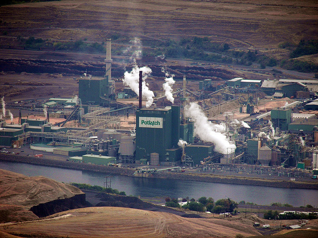
    <title type="html"><![CDATA[Clearwater Paper: Lewiston’s Defining Feature]]></title>
    <summary type="html"><![CDATA[<p><strong><em>The Clearwater Paper mill is one of the first things you notice in Lewiston, Idaho. Known for providing the town with a pungent odor, it has provided thousands of jobs to the people of the Lewis Clark Valley and has a long history in the area. </em></strong></p><img src="https://www.intermountainhistories.org/files/fullsize/76d988c5d48f0d3e760aeca5d51f605f.jpg" alt="Potlatch Paper MIll" /><br/><p>The Clearwater Paper Mill in Lewiston, Idaho (formerly known as the Potlach Paper Mill) is well known to locals for emitting billowing clouds of steam from its smoke stacks. It can be seen and smelled from miles away. People visiting the town notice the stench almost instantly, while the residents hardly notice it because it just becomes natural to them. The mill has been a major provider of jobs in the Lewis and Clark Valley and helped with population growth in the surrounding area. </p><p>The Lewiston Mill was created in 1950 while still under the Potlach Lumber Company name. During World War II, there was a high demand for wood and other timber products. Potlach took advantage of this and became one of the biggest timber companies in the United States and expanded to Lewiston. The Lewiston Mill was unique. It was the first factory to produce bleached poster board from wood waste. Not only was this efficient for the company, but it was also a move that was environmentally conscious as it put wood waste to use. The Lewiston Mill became one of the company’s most successful factories, which resulted in the headquarters moving from San Francisco to Spokane due to Spokane being much closer to Lewiston. Lewiston was also subject to constant new installations and upgrades which, by the 1990s, included a $40 million upgrade to the sawmill and log processor, a $400 million modernization to the pulp and paper mill, and a $107 million upgrade for a twin wire tissue machine. In 1997, Potlach was awarded $95 million from Beloit Corporation due to a defective pulp washer system. </p><p>Due to falling revenue, Clearwater Paper Corporation was created via spin-off in 2008. This was very controversial to the LC valley, as Potlach was a large provider of jobs. Hundreds of lay-offs results from this, but the mill still stayed as a major source of jobs, as well as continued to be a defining feature for the town of Lewiston, Idaho. </p><p><em><strong><a href="https://www.intermountainhistories.org/items/show/178">For more (including 3 images) view the original article</a></strong></em></p>]]></summary>
    <published>2018-05-24T01:22:26+00:00</published>
    <updated>2026-04-17T19:32:02+00:00</updated>
    <link rel="alternate" type="text/html" href="https://www.intermountainhistories.org/items/show/178"/>
    <id>https://www.intermountainhistories.org/items/show/178</id>
    <author>
      <name>Nate Quarry, University of Idaho</name>
    </author>
  </entry>
  <entry>
    <title type="html"><![CDATA[Farragut Naval Training Station]]></title>
    <summary type="html"><![CDATA[<p><strong><em>In its time, the Farragut Naval Training Station was the largest city in Idaho  and the second largest naval training center in the world. </em></strong></p><img src="https://www.intermountainhistories.org/files/fullsize/157f3a87b27c896c2480a88f7a04e6d5.jpg" alt="U.S. Naval Training Station, (Lake Pend Oreille) Farragut, Idaho" /><br/><p>Located between Sandpoint and Coeur d’Alene, Idaho on the southern end of Lake Pend Oreille, the historic Farragut Naval Training Station was a first stop for many fresh recruits during World War II. During its thirty months of existence, more than 293,000 sailors received basic training at Farragut. As the base grew, a city emerged from the land and permanently impacted the environment. The inland naval training location, the unique land attraction, a short but eventful life, and the park that remains all celebrate Farraguts rare and complex history. </p><p>Farragut added jobs, houses, and people to lands that were once used by early tribal affiliation and pioneer explorations. In 1941, the U.S. government purchased the 4,160 acres from two private owners: Kootenai County and a small railway company.  The unique inland naval base is 300 miles away from the western coastlines. Walter Butler Construction Co. employed approximately 22,000 men to build libraries, living quarters, mess halls, chapels, recreation facilities, and other buildings for the base. Neighboring communities, including Sandpoint and Coeur d’Alene, still struggled from the Great Depression. Farragut provided jobs, higher wages, and more opportunities to these communities. </p><p>The groundbreaking for Farragut took place in March 1942. By September 1942, the base population reached 55,000, making it the largest city in Idaho at the time. Farragut was also the second largest naval training center in the world. Recruits left home for the first time, came to Farragut, and learned how to march, row, swim, and use firearms before either heading to the Mediterranean Sea or the South Pacific. The base also contained nearly 900 German prisoners of war who worked beside American soldiers as gardeners and maintenance men.</p><p>The land was attractive to the navy for many reasons. Lake Pend Oreille provided natural aesthetics and raw functionality. The lake’s deep waters, large size, and cool temperatures, along with the steep, tree-lined shores and quiet conditions all created an attractive land-locked location that could closely mimic the ocean without the risks. The base allowed for ground and water training and effectively taught sailors how to take care of themselves in war. The base supplied economic benefits and a textbook location for training; however, the rapid urbanization created pollution and habitat loss to the land and water. </p><p>The once naval training station is now Farragut State Park and remains a tribute to the base. It now caters to tourists with outdoor activities. Bikers, runners, horseback riders, and swimmers can enjoy the land traveled by World War II naval trainers and trainees. Although the land has been transformed and the environment has changed, the natural beauty of the land is protected and maintained by the state. </p><p><em><strong><a href="https://www.intermountainhistories.org/items/show/173">For more (including 3 images) view the original article</a></strong></em></p>]]></summary>
    <published>2018-05-16T23:16:49+00:00</published>
    <updated>2026-04-17T19:32:02+00:00</updated>
    <link rel="alternate" type="text/html" href="https://www.intermountainhistories.org/items/show/173"/>
    <id>https://www.intermountainhistories.org/items/show/173</id>
    <author>
      <name>Darby Pierce, University of Idaho</name>
    </author>
  </entry>
  <entry>
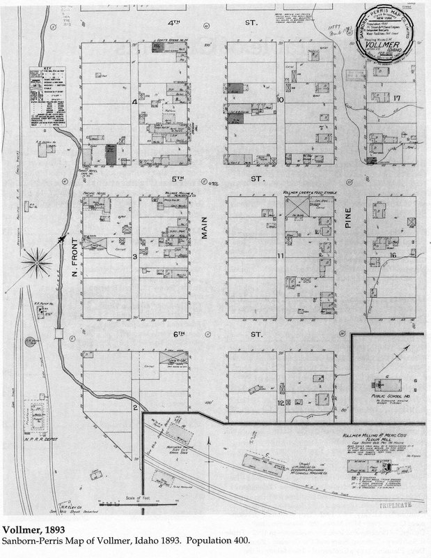
    <title type="html"><![CDATA[Forgotten Vollmer of Idaho]]></title>
    <summary type="html"><![CDATA[<p><strong><em>Idaho’s first millionaire, John P. Vollmer, helped modernize Latah County, Idaho, and created communities. Vollmer, Idaho, was one of those communities although evidence of this initial modernization, this man, and this community are all but vague memories. </em></strong></p><img src="https://www.intermountainhistories.org/files/fullsize/970921c4510994391b9ffa01df9bbe05.jpg" alt="Vollmer Plan 1893" /><br/><p>Although largely forgotten today, John P. Vollmer, greatly influenced northern Idaho in the latter portion of the nineteenth century. He made his fortune in banking, loaning money to farmers, ranchers, and sheep herders. His largest bank and residence was in Lewiston. There he funded large irrigation projects to draw water for agriculture from the Clearwater River. He established the first telegraph line in northern Idaho in 1874, and in 1878 hmade the first Bell telephone exchange on the Pacific coast; however, Vollmer’s influence on the town that once bore his name came in other forms, first praise, then controversy. </p><p>During this period of Latah County history, the greater Inland Empire of eastern Washington and northern Idaho underwent a process of connecting its resources and production with capital interests back east. Major railroad tycoons of the time saw the Inland Empire as a segment of the greater economic machine of the United States. Vollmer’s capital influence in the Palouse and Clearwater regions of the empire obliged him to act as an agent for the Northern Pacific Railway Company, and in 1885 he initiated work to link the economies of Spokane and Lewiston. </p><p>Unfortunately, steepness in grade between the Clearwater Basin and Palouse Hills dictated the most direct route impossible; thus, the rail line diverted from Moscow, the county seat, and eastward through densely wooded and wet low ground known as Huff’s Gulch. In 1889, work to build the railroad between Lewiston and Spokane was complete. Soon after in 1892 the town of Vollmer, Idaho established itself on the site of old Huff’s Gulch. Vollmer himself started one of the first businesses: a mill and livery. Many congregated to the new town, which provided great opportunity because it rested on the edge of both the Palouse Hills and the western white pine forest.</p><p>Settlers within the Inland Empire supported the creation of the railroads because of the opportunity that they afforded. The railroads confirmed that farmers of the region had an active part in the country’s future; however, difficult financial times reminded farmers and settlers of external economic forces that limited profits. The railroads and those who facilitated their creation, Vollmer, symbolized those external forces. In Vollmer, Idaho, praise of the man for his role in bringing the railroad to the Palouse ended with the economic downfall created by the depression of 1893. The nationwide crisis put Vollmer’s banking business at odds with residents of the town because the poor market price for crops caused many farmers to default on their loans.  This was followed by foreclosures imposed by Vollmer’s bank, which forced several farmers to lose their land. As a result, by 1900 Vollmer owned nearly 5,000 acres of agricultural land in Latah County. Due to Vollmer’s business dealings during the depression, the town of Vollmer passed a measure to rename itself to Troy in 1897.</p><p>John P. Vollmer facilitated modernization in Latah County by enabling railroad creation, agricultural processing, and loans; nevertheless, the arduous circumstances caused by the depression of 1893 created a rift between him and the residents of former Vollmer. The town came out of the depression gaining a reputation for opportunity and prosperity under its new name of Troy. The rail line that helped create the town ceased to exist in the late 1980s. Now its former course serves as a scenic bike route between Troy and Moscow. Just like the railroad and the town he helped create, Vollmer, remains only in memory.</p><p><em><strong><a href="https://www.intermountainhistories.org/items/show/115">For more (including 4 images) view the original article</a></strong></em></p>]]></summary>
    <published>2018-01-31T19:56:59+00:00</published>
    <updated>2026-04-17T19:32:00+00:00</updated>
    <link rel="alternate" type="text/html" href="https://www.intermountainhistories.org/items/show/115"/>
    <id>https://www.intermountainhistories.org/items/show/115</id>
    <author>
      <name>Andrew J. Keim, University of Idaho</name>
    </author>
  </entry>
  <entry>
    <title type="html"><![CDATA[Fort Boise&#039;s Historic Transitions]]></title>
    <summary type="html"><![CDATA[<p><strong><em>During the nineteenth century, the Boise Basin hosted an abundance of natural resources. These resources, specifically furs and gold, attracted settlers from the East, triggering a massive migration out West. Settlers, miners, and fur traders traveled the nearby Oregon Trail. A series of fort locations were employed starting in 1834 near the confluence of the Boise and Snake Rivers to provide support and stimulate economic growth by enabling settlers to trade goods with each other and nearby Native tribes. </em></strong></p><img src="https://www.intermountainhistories.org/files/fullsize/62d23d4b423fe9a0d3055e24e29e6bdf.jpg" alt="Fort Boise 2" /><br/><p>Snake Fort, founded in 1834 by Thomas McKay of the Hudson Bay Fur Trading Company, was originally located at the confluence of the Snake and Boise River near present-day Parma, Idaho, at the Oregon border. Later renamed Fort Boise, the fur trading post directly competed with Fort Hall, established by Nathaniel Wyeth, upriver in what is now present-day Pocatello, Idaho. The adobe style structure was highly susceptible to flooding, and Fort Boise was relocated several times within the general vicinity to reduce flooding risk. Within a few years, regional fur trading sharply declined, and the economy of Fort Boise transitioned to salmon fisheries. The great flood of 1853, along with escalating conflicts among settlers and Native Americans in 1854, contributed to its demise. The old fort was abandoned in 1855. </p><p>The new Fort Boise, situated in the heart of downtown Boise, Idaho, was established as a military post by the U.S. government in 1863 under the guidance of Major Pinkney Lugenbeel. Gold mining prevailed in the Boise Basin, and the military post provided a protective buffer to settlers and miners, reducing conflicts between them and surrounding tribes. Inspiration for the design came from brick buildings in Walla Walla, Washington, where Major Lugenbeel stopped on his way to the Boise Basin. Charles May, the builder responsible for the construction of the brick buildings, was hired to assist in the construction of Fort Boise. He used strong materials that consisted of brick and sandstone quarried from the nearby foothills and Table Rock.</p><p>In 1879, Fort Boise was renamed the Boise Barracks and served as a military base and a community center by hosting numerous social events such as theatrical performances, religious services, concerts, balls, tea and dinner parties, dancing, and tennis matches. The fort played a vital role in establishing the city and providing a center for diverse activities, meeting the needs of military and civilian. In the early twentieth century, the decision by the U.S. War Department to reduce small military bases and forts resulted in the fort’s second abandonment. Following several years of vacancy, Governor D.W. Davis loaned the property to the U.S. Public Health Service, enabling World War I veterans to receive treatments from postwar injuries. Passed in 1922, the Hospital Bill qualified veterans to receive medical treatments regardless of active status. The Public Health Service later turned the hospital over to the Veterans Bureau and in 1930 to the Veterans Administration. </p><p>Despite its many shortcomings, Fort Boise became a fundamental component to the development of the current city. Initially facilitating economic growth and prosperity in the region through the trade of natural capital, the fort later transitioned to a protective force, a location for social interaction among settlers and finally a place of healing for the wounded.</p><p><em><strong><a href="https://www.intermountainhistories.org/items/show/174">For more (including 8 images) view the original article</a></strong></em></p>]]></summary>
    <published>2018-05-17T00:07:10+00:00</published>
    <updated>2026-04-17T19:32:02+00:00</updated>
    <link rel="alternate" type="text/html" href="https://www.intermountainhistories.org/items/show/174"/>
    <id>https://www.intermountainhistories.org/items/show/174</id>
    <author>
      <name>Zachary A. Sanchez, University of Idaho</name>
    </author>
  </entry>
  <entry>
    <title type="html"><![CDATA[Grand Old Man of the Mountains: Dave Lewis <br />
]]></title>
    <summary type="html"><![CDATA[<p><strong><em>David Lewis had a propensity for hunting predatory animals, especially cougars, and amassed himself a reputation amongst hunters traveling through Idaho for his skills, affable personality, and hospitality. </em></strong></p><img src="https://www.intermountainhistories.org/files/fullsize/ffc8838450af1319b498822a417d999b.jpg" alt="Dave Lewis with dog and black bear" /><br/><p>David Lewis was a renowned hunter in his time (1844/1855-1936) who other hunters across the West knew as “Uncle Dave,” but today he is regularly referred to as “Cougar Dave” in honor of his cougar and other animal hunting prowess. </p><p>Not much is known about Lewis’s early life due to being a private man. Even his exact age is unclear, as Lewis periodically lied about it depending on who was asking, but most accounts put his birth year as 1844 in New Orleans, Louisiana. However, there is compelling evidence to indicate that he was actually born in 1855 in Yoncalla, Oregon.  Lewis’s parents travelled to Willamette Valley along the Oregon Trail in the 1850s. Lewis claimed to have been at the Siege of Vicksburg for the Union Army with James “Wild Bill” Hickok, but he would have been 7 at the time. Later, he served at the Battle of Little Bighorn as a scout under Captain Frederick Benteen. During the Sheepeater Campaign of 1879, Lewis was the packer in charge of the two-mule ammunition train and the brief war was his first experience in the area. </p><p>Lewis had a particular hatred for cougars, and he began his long career of cougar hunting soon after the Sheepeater Campaign, and by 1888 he had earned himself the reputation of “Cougar Dave” for his talents. The Forest Service hired Lewis as a “Forest Guard (Hunter)” on April 1, 1910, for “the destruction of the animals on the Forest” for what should have been a two-month stint became his job for several years. </p><p>Forest management practices and beliefs of the time treated predatory animals, such as wolves, coyotes, foxes, bears, and cougars, as threatening to game in the forest. Dominant policy of the time meant that exterminating predatory animals would protect the wildlife that humans valued, including mule deer, elk, bighorn sheep, and mountain goats. His reputation for hating and killing cougars was reflected in local tall-tales, where in one legend it is claimed that Lewis treed a cougar, dropped his rifle to climb after the cat, and wrestled it out of the tree where it fell to his dogs waiting below. While Lewis never wrestled a cougar out of a tree, he reportedly went on to kill over 1,000 cougars in his lifetime.</p><p>Lewis fell in love with the region known today as the Frank Church-River of No Return Wilderness, but in his lifetime would eventually become known as the Idaho Primitive Area. In 1924, Lewis would later claim a 65-acre homestead along Big Creek seven miles upstream from the Middle Fork of the Salmon River, a land he first experienced during the Sheepeater Campaign. After catching pneumonia Lewis travelled 33 miles from his homestead to his nearest friend. He was then taken to the Boise’s Veteran’s Hospital over 100 miles away. He passed away the next day. The Idaho Statesmen had this to say about Lewis’s death, “Old age closed Friday morning the career of Dave “Cougar Dave” Lewis, nationally famous cougar killer and Idaho’s grand old man of the mountains.”</p><p><em><strong><a href="https://www.intermountainhistories.org/items/show/301">For more (including 4 images) view the original article</a></strong></em></p>]]></summary>
    <published>2019-02-13T11:12:08+00:00</published>
    <updated>2026-04-17T19:32:05+00:00</updated>
    <link rel="alternate" type="text/html" href="https://www.intermountainhistories.org/items/show/301"/>
    <id>https://www.intermountainhistories.org/items/show/301</id>
    <author>
      <name>Burgundy Johnson, University of Wisconsin Oshkosh</name>
    </author>
  </entry>
  <entry>
    <title type="html"><![CDATA[Lake Pend Oreille: Booming Industries and Depleting Resources]]></title>
    <summary type="html"><![CDATA[<p><strong><em>The last domesticated region in Idaho, known as Lake Pend Oreille, contains a long history of human activity. Pend Oreille’s first inhabitants include indigenous peoples followed by fur traders, explorers, miners, and loggers. The lake received its name from Canadian fur trapper and mapmaker David Thompson. The words “Pend Oreille” are French for “an ear pendant” or “hangs from ears”, possibly referring to the lakes shape or the jewelry worn by the Kalispel Indians who resided there. </em></strong></p><img src="https://www.intermountainhistories.org/files/fullsize/14e0b562f8c4bad39231ac3a23bec93f.jpg" alt="Pend d&#039;Oreille Lake" /><br/><p>In the fall of 1809, a fur agent with the North-West Company named David Thompson found Lake Pend Oreille. Thompson recognized the environmental value the area held.  Years after making the discovery, he wrote in his memoir, “The impression of my mind is, from the formation of the country and its climate, its extensive Meadows and fine forests, watered by countless brooks and Rills of pure water, that it will become the abode of civilized Man, whether Natives or other people.” Soon after his arrival, Thompson established a fur-trading outpost called the Kullyspell House. It was the first permanent wooden structure in Idaho next to Lake Pend Oreille and was named after the Kalispel Indians who guided Thompson around the Columbia River Basin. Once Thompson succeeded with his trading house, he moved on to other adventures, leaving Finan McDonald in charge. The location was forgotten until 1928 when a group of Idaho historians were guided by a blind Kalispel man to the remains of the trading outpost on the lake. </p><p>Lake Pend Oreille’s history did not end with Thompson and the Kullyspell House; the area grew over the next two hundred years. With the beginning of the gold rush era in 1866, the lake served as a passage for miners traveling from the Columbia River to Helena, Montana. With the ending of one boom comes the beginning of another. The demand for timber reached North Idaho, one of the largest areas of timber in the United States. The industry began in 1880 when Robert Weeks opened a general store dealing furs in the lake’s largest community, Sandpoint, in the panhandle of Idaho. As the town expanded so did the timber industry, along with the establishment of several sawmills, including the world-class Humbird Mill. The mill sparked modernization in the little lake town. By 1920, Sandpoint became the largest shipper of cedar poles and pilings in the Northwest. </p><p>The towns’ populations grew as the industries surrounding the lake attracted people from all over the country. Today, the location is featured in the media as one of the last, best places to live, but with its discovery came the chopping of its meadows and forests. This was followed cultivation and logging, which caused pesticides and other chemicals to drain into the lake. Just as David Thompson stated in his memoir, Lake Pend Oreille did become an abode for man and suffered from the exploitation of its abundant resources along with pollution from its inhabitants.</p><p><em><strong><a href="https://www.intermountainhistories.org/items/show/171">For more (including 3 images) view the original article</a></strong></em></p>]]></summary>
    <published>2018-05-16T01:42:20+00:00</published>
    <updated>2026-04-17T19:32:02+00:00</updated>
    <link rel="alternate" type="text/html" href="https://www.intermountainhistories.org/items/show/171"/>
    <id>https://www.intermountainhistories.org/items/show/171</id>
    <author>
      <name>Madison Huck, University of Idaho</name>
    </author>
  </entry>
  <entry>
    <title type="html"><![CDATA[Magee Historic Ranger Station]]></title>
    <summary type="html"><![CDATA[<p><strong><em>Located in Pritchard, Idaho, on the little North Fork of the Coeur d’Alene River, the historic Magee Ranger Station was a hub of activity throughout the twentieth century. Utilized as a homestead, Forest Service ranger station, work camp for the Civilian Conservation Corps (CCC), and again during World War II as an emergency landing strip, the area has a rich and complex history.</em></strong></p><img src="https://www.intermountainhistories.org/files/fullsize/0c8bddd3dec2123f8e5797dad2ed39b4.jpg" alt="Blister Rust Crew" /><br/><p>In September 1905, Charles Magee built a homestead on the Trail Creek-Tepee Creek confluence - the first recorded non-Indian settlement of the area, . He constructed a small cabin and a couple outbuildings which may have been a woodshed, stable, and tack barn. In 1908, the Secretary of Agriculture appropriated a portion of Magee’s homestead as a Forest Service administrative site, calling it the Magee Ranger Station. He approved the Forest Service station in the area with the intent of localizing management resources in the remote North Fork of the Coeur d’ Alene River. District ranger Howard Drake and his men added the first official administrative building in 1908 with Charles Magee, followed by later headquarters in 1915 and 1922. Forest Service personnel then used the station on a seasonal basis from 1908 to 1973 for road construction, fire suppression, trail maintenance, and logging. After 1973, the Forest Service assimilated the Magee Ranger District into the Wallace and Fernan districts and the station was decommissioned. Eight years later in 1981, the Magee Ranger Station became listed on the National Register for Historic Places in Shoshone County.</p><p>In addition to Forest Service activities, the CCC established a personnel base camp and work Camp F-134 in May 1935 as part of President Franklin D. Roosevelt’s New Deal programs to employ young men across the country for public works projects. At its peak, the camp housed 400 men in Company 544 which constructed roads, maintained trails, and eradicated white-pine blister rust, a fungus disease that eradicated much of the white pine populations in Idaho within 70 years of its introduction in 1910. In the 1940s after the CCC program ended and at the onset of U.S. participation in World War II, the Army Corps of Engineers constructed an emergency landing field for fighter aircraft between 1942 and 1943. Locals reported that fighter aircraft never visited the landing strip during the war. In addition to the gravel airstrip, military personnel also built a small bunkhouse near the runway. Today, the airstrip can still be seen, while the bunkhouse is no longer standing.</p><p>Today, the Historic Magee Ranger Station and the surrounding area is a prime location for recreation and tourism. Locals and residents from across the Pacific Northwest come to hike, camp, ride horses, and float the river during the summer. The Magee Station ranger’s cabin is open to public rental during summer months and the other structures that remain are open to viewing for those interested in the longstanding and rich history associated with the area. </p><p><em><strong><a href="https://www.intermountainhistories.org/items/show/116">For more (including 5 images) view the original article</a></strong></em></p>]]></summary>
    <published>2018-02-01T02:52:06+00:00</published>
    <updated>2026-04-17T19:32:00+00:00</updated>
    <link rel="alternate" type="text/html" href="https://www.intermountainhistories.org/items/show/116"/>
    <id>https://www.intermountainhistories.org/items/show/116</id>
    <author>
      <name>Nate Kimball, University of Idaho</name>
    </author>
  </entry>
  <entry>
    <title type="html"><![CDATA[Outfitting To Research: The University of Idaho’s Taylor Wilderness Research Station<br />
]]></title>
    <summary type="html"><![CDATA[<p><strong><em>The University of Idaho has owned a research station in the Frank Church-River of No Return Wilderness Area in Idaho since 1969. The station focuses on environmental education for undergraduates and graduates from all over the country.</p></strong></p><img src="https://www.intermountainhistories.org/files/fullsize/eba0f931e10054f7c695dd20aac456f0.jpg" alt="Looking towards Taylor on the bridge" /><br/><p>The Taylor Wilderness Research Station in the Frank Church-River of No Return Wilderness Area has been owned by many people over the years. The University of Idaho (UI), who owns it now, acquired the property from Jess and Dorothy Taylor in 1969 for $100,000, who had bought the property from David “Cougar Dave” Lewis in 1935 for $1,200. The university intended to fund the research station for a couple years before research grants would fund it self-sufficiently, a hope that remains unfulfilled. The station has adapted, though, and still focuses on education and research. </p><p>One unique opportunity at the station is the University of Idaho’s Semester in the Wild Program. This program allows students to spend a semester in the wilderness taking an integrated set of classes in the sciences and humanities, while receiving field experience. </p><p>The main focus and goal for the research station has remained education, broadly defined, rather than publishable research. The research station produced even more educational research opportunities when the university bought it. For example, the caretakers Jim and Holly Akenson, who were hired by UI, managed the property from 1982 to 2003 and developed an internship program, accepting and encouraging interns and students to come do research, especially in wildlife ecology. The Akensons took the interns on backpacking and horseback riding excursions to trap wolves, cougars, bobcats, and bears to tag them and collect data. They also investigated carcasses they happened across to determine how that animal was killed. Mostly, this research focused on students’ learning opportunities and backcountry skill-building rather than academic publication. It worked, because student experiences made them more marketable for future jobs. </p><p>In recent decades, the station moved towards more long-term monitoring programs, reflecting shifts in the history of ecology, which will provide the groundwork for potential future research. Some long-term monitoring efforts have already happened. For example, bird observations are made over the seasons to determine the presence or absence of specific bird species. Another project has compared the biomass of bluebunch wheatgrass to bighorn sheep populations. This research has been active for more than 25 years. As for today, one of the caretakers is conducting a research project on the pheromones of cougars to determine if we can identify cougars based on their different smells alone. UI also collaborates; Idaho State University researchers come to the research station each year to sample multiple creeks in the Big Creek drainage, looking at the riparian area and stream productivity. This has been conducted for 31 years, which gives us data from before a major fire in 2000 that significantly affected the ecological relationships in the watershed. Research here is limited to non-invasive practices, because it is a wilderness area. Permits also limit the station’s ability to conduct research in the area. However, even with the regulations in wilderness, research continues. The size of the wilderness area makes TWRS an especially useful research site in many of the environmental sciences. </p><p>The station is invaluable for giving students hands on field experience in an unusual learning environment. It allows long-term research to be carried out in a place where getting research permits can be hard. The educational opportunities that are provided here let students from all over the country experience wilderness and education in a whole new way.  </p><p><em><strong><a href="https://www.intermountainhistories.org/items/show/303">For more (including 3 images) view the original article</a></strong></em></p>]]></summary>
    <published>2019-02-15T00:30:07+00:00</published>
    <updated>2026-04-17T19:32:05+00:00</updated>
    <link rel="alternate" type="text/html" href="https://www.intermountainhistories.org/items/show/303"/>
    <id>https://www.intermountainhistories.org/items/show/303</id>
    <author>
      <name>Hailey Shannon, University of Idaho</name>
    </author>
  </entry>
  <entry>
    <title type="html"><![CDATA[Potlatch Lumber Mill and the Company Town]]></title>
    <summary type="html"><![CDATA[<p><strong><em>Potlatch, Idaho, is a small town on the edge of the Palouse region of Idaho, originally built to house the employees of the world’s largest white pine sawmill.  The Potlatch Lumber Company’s mill in Potlatch employed hundreds in its almost eighty-year lifespan and produced millions upon millions of board feet of lumber. </em></strong></p><img src="https://www.intermountainhistories.org/files/fullsize/d30a6c53feae4f8e778093fbea5eba7a.jpg" alt="Potlach Mill Workers" /><br/><p>In 1903, the Potlatch Lumber Company was incorporated by William Deary of the Northland Pine Company (a company established by the Weyerhaeuser Syndicate) and Henry Turrish of Wisconsin Log and Lumber.  These men who were originally competitors chose to collaborate in pursuit of keeping land prices down by merging their companies to form the Potlatch Lumber Company.  The mill opened in 1906 and processed the company’s holdings of over 100,000 acres of western white pine and other timber holdings around the region.  The mill was one of the largest sawmills in the United States at the time and was the largest white pine sawmill in the world.   </p><p>The company soon decided to build a town on the hills near the mill to house their employees.  Established with 128 homes and soon after a hotel, churches, a general store, and schools, the town continued to grow.  The town, aptly named Potlatch, symbolized pride for the company.  By 1907 over two hundred houses had been built.  Much of the workers housing had been constructed in haste, often with green lumber, resulting in constant remodeling of windows, doors, and flooring.  Company Towns were not uncommon in the Pacific Northwest, dozens of them dotted across the landscapes of Idaho, Washington and Oregon.  These towns would see a great “boom” but most met the same fate when a “bust” occurred and the communities shrunk into shells of their former selves.</p><p>When the mill first opened it could cut 350,000 feet of lumber in a single ten-hour shift.  An eighteen-hundred horsepower steam engine powered the mill and drove a series of belts that worked the various machines and implements.  The power plant produced enough excess steam to heat many of the houses in town.  In its early days the mill employed five hundred workers and thirty horses to operate.   In the 1950s, the mill transitioned from its steam engine and series of belts and pullies, to individual electric motors on machines, modernizing the facility. </p><p>Although there had been a lot of product moving through the mill in the past several decades, the mill had begun to downsize and in August 1981 the sawmill closed due to dropping lumber prices in a depressed market, forcing two hundred people out of work.  Workers and residents hoped, like several closures before, that it would only be a temporary shut-down until the market recovered.  In March 1983, however, Potlatch Corporation announced that the closure would be permanent, and the mill was quickly torn down and the materials salvaged.  During its heyday Potlatch had over fifteen-hundred residents, today the population has idled around eight hundred.  </p><p><em><strong><a href="https://www.intermountainhistories.org/items/show/112">For more (including 8 images) view the original article</a></strong></em></p>]]></summary>
    <published>2018-01-31T19:21:49+00:00</published>
    <updated>2026-04-17T19:32:00+00:00</updated>
    <link rel="alternate" type="text/html" href="https://www.intermountainhistories.org/items/show/112"/>
    <id>https://www.intermountainhistories.org/items/show/112</id>
    <author>
      <name>Zac Carscallen, University of Idaho</name>
    </author>
  </entry>
  <entry>
    <title type="html"><![CDATA[Riverside Dance Hall]]></title>
    <summary type="html"><![CDATA[<p><strong><em>The Riverside complex was a popular community venue and social hotspot for the residents of Potlatch, Idaho, and the surrounding Palouse from its construction in the 1930s to its closing in the 1960s. Riverside provided a social gathering place outside of town where citizens and employees of Potlatch connected with others from the surrounding area.</em></strong></p><img src="https://www.intermountainhistories.org/files/fullsize/73cae1c5f424d4837c4fef0cb8ab1b6c.jpg" alt="William Deary Memorial" /><br/><p>Potlatch, Idaho, a small North Idaho town, was the location of the world’s largest lumber mill from its construction in 1906 to its closure in 1981. Potlatch Lumber Company employed hundreds of people in the mill as well as in the various company-owned businesses. The town was built by the company to provide housing for its employees. The company provided several options for recreation, often in the now historic gymnasium. Despite the dominant presence of the company, there were other places for entertainment within a short drive. One of the most fondly remembered and universally enjoyed was Riverside, the octagonal building off what is now Highway 95 at the base of Riverside Hill. The building served as a dance hall, concert venue, and later a roller skating rink. The grounds included the building, as well as a racetrack and rodeo grounds. </p><p>The first iteration of the iconic Riverside building was constructed in the 1920s. Ray Hanson constructed the building most people associate with Riverside in the 1930s after a fire destroyed the first. Much of the lore surrounding the popular gathering place comes from the oral histories and stories from the older generations that are shared both in private and at the many community events.</p><p>Many people look back fondly on the iconic race track and dance hall located at Riverside. The venue hosted some of the most famous country and western singers The Grand Ole Opry had to offer. Those big names include but are not limited to Hank Thompson, Johnny Cash, Tex Ritter, George Jones, and Dolly Parton. Even former University of Idaho Professor and proud Potlatch resident Malcolm Renfrew played his trombone at Riverside. It was thanks to the efforts of owners Leonard and Marlene Zahnow that Riverside drew the star power and surrounding communities to the dance hall. The couple, along with Leonard’s father Wesley, owned the venue from 1957 to 1962. The couple dedicated their time to caring for the grounds and maintaining the building to ensure both locals and performers would come back for another good time at Riverside. Due to yearly floodwaters from the Palouse River and the high maintenance costs attributed to the flooding, the Zahnows sold the dance hall in 1962. Soon after the sale the building succumbed to the years of flood damage and fell into disrepair. </p><p>Ask residents of the town who were around in the 1950s and 60s and they will be able to tell you a story about their experiences at Riverside. The joy of a place like Potlatch and its population are the stories the younger generations get to hear at celebrations like Potlatch Days and the new Return to Riverside music festival. The Riverside dance hall will forever be in the memory of Potlatch and the surrounding Palouse. </p><p><em><strong><a href="https://www.intermountainhistories.org/items/show/120">For more (including 5 images) view the original article</a></strong></em></p>]]></summary>
    <published>2018-02-01T03:42:31+00:00</published>
    <updated>2026-04-17T19:32:00+00:00</updated>
    <link rel="alternate" type="text/html" href="https://www.intermountainhistories.org/items/show/120"/>
    <id>https://www.intermountainhistories.org/items/show/120</id>
    <author>
      <name>Charlie Taylor, University of Idaho</name>
    </author>
  </entry>
  <entry>
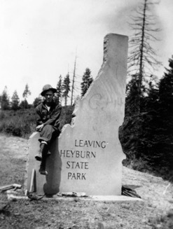
    <title type="html"><![CDATA[Senator Heyburn and the Northwest&#039;s First State Park]]></title>
    <summary type="html"><![CDATA[<p><strong><em>In 1908 Heyburn State Park became the Idaho's first state park and the first in the entire Pacific Northwest. Senator Weldon Heyburn pushed to create a national park in Idaho, but had to settle on a state park. Heyburn State Park developed and grew with the region, creating a local and regional recreation spot for people to enjoy. </em></strong></p><img src="https://www.intermountainhistories.org/files/fullsize/46e5b97f8a2153ec2101d9da7440942b.jpg" alt="Heyburn State Park Sign" /><br/><p>When Senator Weldon Heyburn begain dreaming of a new national park in Idaho, the General Allotment Act of 1877 had recently opened up a large swatch of land. After this Act, members of the Coeur d’ Alene Indian Tribe people each received 160 acres of land, and the rest would be divided among homesteaders. Since the land was Indian land, Congress got involved. In 1907 Heyburn introduced two bills aimed at creating a national park in Idaho. But both stalled in the House Committee on Indian Affairs. A second bill passed after a word change without Heyburn’s knowledge. The wording changed the park from a national park to a state park, allowing Idaho to buy land. Heyburn strongly opposed the idea of a state park, stating, “I do not believe in creating a park that shall be the property of the state…They are always a subject of political embarrassment.” Despite his opposition, President Theodore Roosevelt signed the bill into law on April 30, 1908. </p><p>After the formation, Heyburn State Park grew to meet the needs of the many visitors. The area was already a local vacation spot with many people renting houseboats for the summer. Local newspapers saw the park creating new opportunities. State Game Warden, Ben Gray, had high hopes for the park, stating, “There is no doubt in my mind but that Heyburn park will become a mecca for pleasure seekers in this state and its reputation will spread throughout the entire northwest.” He shared this vision with Governor James Hawley and George Pickett, who made up the Heyburn State Park commission. They envisioned a place where people could moor their houseboats, fish and hunt, and recreate during the year. A writer for the Idaho Statesman described how great the fishing was in the park, and declared, “The black bass and perch at Heyburn park not only grow to a large size, but are finely flavored, and fishing is therefore one of the main attractions there.” Other newspapers as well reported on the array of recreational opportunities. Plans were underway to create a hotel in the park to draw in more tourists. Not only did people view Heyburn State Park as a place away from the city, but also a good place for healing the sick. A doctor from Washington was interested in building a sanitarium inside the park. During the 1930s, Heyburn State Park underwent several improvement projects by the Civilian Conservation Corps. The project superintendent, Rex Wendle, said that the work done by the men in the CCC transformed the park: “Heyburn State Park was changed from a forest area to a real park by the National Park Service using CCC labor.” They constructed buildings, roads, campgrounds, and brought power to the park. </p><p>Heyburn State Park gave the people of Idaho a place to unwind and enjoy the outdoors. The Idaho Statesman again placed high praise on the park, writing, “Thousands of acres of this is fitted for camping purposes. Springs of the purest and coldest water imaginable abound, and there are no snakes and but a few noxious insects. I didn’t see a mosquito." The exaggerated description showed how proud they were to have a state park. </p><p><em><strong><a href="https://www.intermountainhistories.org/items/show/121">For more (including 4 images) view the original article</a></strong></em></p>]]></summary>
    <published>2018-02-01T03:47:03+00:00</published>
    <updated>2026-04-17T19:32:00+00:00</updated>
    <link rel="alternate" type="text/html" href="https://www.intermountainhistories.org/items/show/121"/>
    <id>https://www.intermountainhistories.org/items/show/121</id>
    <author>
      <name>Vince Wilson, University of Idaho</name>
    </author>
  </entry>
  <entry>
    <title type="html"><![CDATA[St. Joe River and the Wild and Scenic Rivers Act]]></title>
    <summary type="html"><![CDATA[<p><strong><em>The Wild and Scenic Rivers Act set aside rivers for preservation and included about 891 miles of Idaho’s rivers. The St. Joe River in northern Idaho is one example.</em></strong></p><img src="https://www.intermountainhistories.org/files/fullsize/d879e12d45b986f56479f38009383cc2.jpg" alt="St. Joe River rafting, Idaho 3" /><br/><p>Idaho Senator Frank Church was a driving force behind the Wild and Scenic Rivers Act. In 1965, Senator Church introduced a new bill called the National Wild Rivers Bill. This served as a basis for what became the Wild and Scenic Rivers Act. Frank Church understood the importance of protecting America’s rivers stating, “If we fail to give these rivers . . . statutory protection now, while there is still time, we shall have only ourselves to blame later, when time has run out.” The forward thinking of Church helped push rivers into the legislative spotlight and led to the designation of numerous Idaho rivers. </p><p>On October 2, 1968, Lyndon B. Johnson signed the Wild and Scenic Rivers Act declaring, “An unspoiled river is a very rare thing in this Nation today. Their flow and vitality have been harnessed by dams and too often they have been turned into open sewers by communities and by industries.” The act signified a concerted effort to protect America’s rivers. Once the act passed, the U.S. Forest Service created teams to study many of Idaho’s rivers to see if they met the criteria of a wild and scenic river. In order to be classified, rivers needed to meet certain criteria, “Their immediate environments, possess outstandingly remarkable scenic, recreational, geological, fish and wildlife, historic, cultural, or other similar values, shall be preserved in free-flowing condition.” Those remarkable values elevated some rivers above others. After the establishment of those values, a river was put into one of three categories, wild, scenic, or recreational. To qualify as wild, a river could have neither developments nor dams and only be accessible by trail. Scenic rivers also needed to be dam-free and mostly undeveloped. Roads were allowed on scenic rivers along with trails. Lastly, recreational rivers could be accessed by both roads and trails, and there can be some development, like campgrounds, along the river. The river could still be classified as recreational even if a dam or diversion altered the course of the river in the past. Rivers could have sections that encompassed all three or just one designation. Idaho’s rivers incorporated the full range of the outstanding remarkable values and designations. </p><p>In 1969, Idaho Governor Don Samuelson requested a joint study with the Forest Service and Idaho Water Resource Board to assess the St. Joe River. In 1974, the study found the river met the criteria for inclusion into the National Wild and Scenic Rivers System and was formally designated on November 10, 1978. The scenery, recreational opportunities, and the abundance of fish and wildlife were deemed exceptional in and along the river, and 39.7 miles were designated as wild while 26.6 miles were designated as recreational. </p><p>While the mileage of rivers included in the National Wild and Scenic Rivers System is low, the passing of the act helped preserve rivers from pollution and development. In doing so, it created a system of rivers that can be enjoyed by future generations. </p><p><em><strong><a href="https://www.intermountainhistories.org/items/show/177">For more (including 3 images) view the original article</a></strong></em></p>]]></summary>
    <published>2018-05-22T00:47:52+00:00</published>
    <updated>2026-04-17T19:32:02+00:00</updated>
    <link rel="alternate" type="text/html" href="https://www.intermountainhistories.org/items/show/177"/>
    <id>https://www.intermountainhistories.org/items/show/177</id>
    <author>
      <name>Vince Wilson, University of Idaho</name>
    </author>
  </entry>
  <entry>
    <title type="html"><![CDATA[The Lobauer-Estep Murder at Big Creek, Idaho<br />
]]></title>
    <summary type="html"><![CDATA[<p><strong><em>Two miners, Walter Estep and Frank Lobauer, on Ramey Ridge in Big Creek became enemies after a faulty deal and an affair. When they failed to resolve their problem after seeking help from officials, Lobauer took matters into his own hands and promptly reported his deeds.</p></strong></p><img src="https://www.intermountainhistories.org/files/fullsize/df20c4d50173f80ad3393e0e0ced767c.jpg" alt="Frank Lobauer 1936
" /><br/><p>Before the paths of Walter Estep and Frank Lobauer fatally crossed, they were neighbors who mined on Ramey Ridge in Big Creek. Previously a forest ranger, Estep, born in 1893, moved to Acorn Creek Ranch on Ramey Ridge in 1930. Born in 1884, Lobauer was a short man, not quite 5’4”, who was cross eyed and balding. Lobauer and his wife, Myrtle Bland Geer, moved to Big Creek in the 1920’s. This area along Big Creek was a popular site for mining with many homesteads used primarily for mining claims. </p><p>The two men became acquainted when Lobauer was contracted to work in one of Estep’s mines in exchange for an interest in the group. However, after finishing the work, Estep changed his mind about paying Lobauer. Meanwhile, Estep also had seduced Lobauer’s wife in what became a three-year affair with two children resulting. These intimate details of the feud were common knowledge among locals. In late 1935, Lobauer finally acted, traveling to the Warren Ranger Station to contact Ranger Gene Briggs. Despite an extensive telephone network in the area, without a phone Lobauer had to travel to contact authorities. Since he was absent at the time, Lobauer related the details to Briggs’s wife, Hiley, and demanded Estep to be placed under a peace bond to stay away from Myrtle. He added that if the sheriff failed to stop the affair, he would kill Estep. The isolation of the area did not provide Lobauer with many ways of taking immediate action. Hiley called the sheriff and relayed message; however, she omitted Lobauer’s threat. </p><p>On December 2, Estep acted as an attorney to help transfer the deed of the Dave Lewis property to Jess Taylor, a hunting ranch three miles downstream from Lobauer’s camp on Big Creek. According to Lobauer, as Estep was returning from the Lewis cabin, he saw Lobauer waiting with a gun and went to grab it. They agreed to talk things over and Lobauer asked Estep for the money he was owed. However, Estep refused to pay. Lobauer replied, “I’ll settle you with a bullet” and shot and killed Estep as he walked out the door. Lobauer visited Lewis and asked him to notify the sheriff. The sheriff sent a local to investigate as he couldn’t reach the remote area until the next day. Lobauer was found sitting inside his tent drunk. Estep’s body was still lying in the doorway with a bullet hole through the back of his neck and out of his mouth with blood spattered all over the snow. </p><p>Lobauer was arrested and sent to the Valley County Jail in Cascade where he admitted to the murder, but later pleaded not guilty in trial. In 1936, Lobauer was convicted of manslaughter and sentenced to 5 to 10 years in the Idaho State Penitentiary in Boise, Idaho. He spent eight years in prison until he was released in 1942. Six years later, Lobauer returned to Big Creek where he was last seen heading out to an old mining claim by foot in the snow. </p><p><em><strong><a href="https://www.intermountainhistories.org/items/show/305">For more (including 5 images) view the original article</a></strong></em></p>]]></summary>
    <published>2019-02-15T01:10:30+00:00</published>
    <updated>2026-04-17T19:32:05+00:00</updated>
    <link rel="alternate" type="text/html" href="https://www.intermountainhistories.org/items/show/305"/>
    <id>https://www.intermountainhistories.org/items/show/305</id>
    <author>
      <name>Madi Thurston, University of Idaho</name>
    </author>
  </entry>
  <entry>
    <title type="html"><![CDATA[The Mission of the Sacred Heart ]]></title>
    <summary type="html"><![CDATA[<p><strong><em>Located in Coeur d’Alene’s Old Mission State Park, the Mission of the Sacred Heart is the oldest building in Idaho. Also known locally as the Cataldo Mission, or Old Mission, the Mission of the Sacred Heart was built between 1850 – 1853 by Catholic missionaries and members of the Coeur d’Alene Tribe. It is listed on the National Register of Historic Places and is the oldest mission building in the Pacific Northwest. </em></strong></p><img src="https://www.intermountainhistories.org/files/fullsize/18aa16b18593eeda0e9dd7d760561341.jpg" alt="FRONT and EAST SIDE ELEVATIONS - Sacred Heart Mission" /><br/><p>In the early nineteenth century, the Coeur d’Alene Indians began to hear rumors of men in black robes who possessed special powers. Curiosity about these alleged powers inspired the tribe to invite the “black robes” to live amongst them. Jesuit missionaries arrived in the St. Joe River area in the early 1840s and built the St. Joe Mission in 1842. Due to seasonal flooding the mission was abandoned and relocated near the Coeur d’Alene River and modern day Cataldo, Idaho.</p><p>Father Antonio Ravalli modeled the mission after the cathedrals of his Italian homeland. Construction began in 1850 and three hundred Coeur d’Alene Indians and two missionaries built the ninety-foot-long, forty-foot-high, and forty-foot-wide building. The construction required creativity due to minimal building supplies. No nails were used, the chandeliers were made from old tin cans, and the walls were built by weaving grass and straw over a framework then solidifying it with river mud, a method known as waddle and daub. </p><p>When completed in 1853, the Mission of the Sacred Heart became an important stop for westward settlers, miners, traders, and religion seekers. The original goal of the mission was to serve as a reduction community, bringing Indians from nearby communities to one gathering place to focus on religion and the adoption of Jesuit agricultural practices. It also provided supplies and hospitality in this remote part of the West. By the 1870s, the mission and surrounding farm had grown to between eighty and one hundred acres and made full use of the Coeur d’Alene valley for grazing and cultivation. </p><p>In 1961 the Mission of the Sacred Heart was designated a National Historic Landmark, and in 1966 was added to the National Register of Historic Places. A mural of the mission can be seen on the walls of the Brumidi Corridors at the U.S. Capitol building and is the only landscape depicted there that shows a building that still exists today. The mission is the oldest building in the state of Idaho and is now a part of Coeur d’Alene’s Old Mission State Park. The park includes the Mission and the restored Parish house (which was burnt down in 1887), along with two cemeteries, nature trails, and a visitor center. </p><p><em><strong><a href="https://www.intermountainhistories.org/items/show/172">For more (including 4 images) view the original article</a></strong></em></p>]]></summary>
    <published>2018-05-16T03:39:31+00:00</published>
    <updated>2026-04-17T19:32:02+00:00</updated>
    <link rel="alternate" type="text/html" href="https://www.intermountainhistories.org/items/show/172"/>
    <id>https://www.intermountainhistories.org/items/show/172</id>
    <author>
      <name>Trevor McEvers, University of Idaho</name>
    </author>
  </entry>
  <entry>
    <title type="html"><![CDATA[The Oasis Rooms]]></title>
    <summary type="html"><![CDATA[<p><strong><em>With roots in the late-nineteenth century silver book, Wallace Idaho's last operating brothel did not close until 1991. </em></strong></p><img src="https://www.intermountainhistories.org/files/fullsize/c41f499b8768b192d688599860d477b8.jpg" alt="Oasis Room sign" /><br/><p>Wallace, Idaho has a history of indulging in vices and lasciviousness. Since its establishment members of the local government engaged in the illegal prostitution and gambling activities produced as an outlet for miners in the community. This led to continued government corruption that perpetuated into the mid twentieth century. From 1963 to its unexpected closing in 1988, Ginger Murphy ran The Oasis Rooms. When Murphy bought The Oasis, mining and prostitution were declining in profits and popularity. Due to this government corruption and other allegations of prominent members in the community, it was not until 1973 that the town ordered all operating brothels to shut down. Each brothel took down its business signs, hid from the public eye, and operated in secret. Consequently, the brothels of Wallace flourished until each shut down decades later.</p><p>The Oasis brought in profits near one million dollars a year and on a good weekend each woman could earn upwards of two thousand dollars. Before the Oasis closed in 1988, Madam Ginger employed anywhere from five to eight women. Each woman worked for two weeks and had two weeks off, completing shifts from two in the afternoon to six in the morning and averaged anywhere from thirty-five to forty customers a night. The turnover rate of women was high. Most of the workers traveled across the Northwest and would not stay for more than a few weeks in Wallace. Competition for a spot at Madam Ginger’s was tough because she paid her women a 60/40 cut, unlike most madams who paid 50/50 of the profits. Madam Ginger took good care of her employees. Each woman was subject to weekly doctors’ visits to screen for pregnancy and sexually transmitted diseases. Ginger employed “maids” who not only kept house but watched out for the women’s safety. They would set the timer for the clients, drop profits into each woman’s lock box, and use the reverse peephole in each room to check on the women in case they heard anything out of the ordinary. Until 1988 this was the norm for the women employed.</p><p>In Wallace, the FBI investigated the town and its questionable operations often. On June 23, 1988, an informant tipped off Madam Ginger and her eight employees to an FBI raid. As this was a common occurrence, the women packed a bag and left the brothel with most of their possessions left behind. They expected to be back to their temporary homes within a few weeks but the FBI had ongoing investigations that lasted longer than normal. Madam Ginger abandoned the building until local Jack Mayfield bought it years later and discovered the rooms were left just as they had been the day the women left. </p><p>Today, The Oasis Bordello Museum provides an inside look to the women’s abandoned bedrooms and personal items including lingerie, eight-track tapes, and various toiletries.  The museum gives the visitor an inside look into the lives of these women and a glimpse of what it was like as a sex worker.  </p><p><em><strong><a href="https://www.intermountainhistories.org/items/show/122">For more (including 3 images) view the original article</a></strong></em></p>]]></summary>
    <published>2018-02-01T03:53:56+00:00</published>
    <updated>2026-04-17T19:32:00+00:00</updated>
    <link rel="alternate" type="text/html" href="https://www.intermountainhistories.org/items/show/122"/>
    <id>https://www.intermountainhistories.org/items/show/122</id>
    <author>
      <name>Caila Zimmerman, University of Idaho</name>
    </author>
  </entry>
  <entry>
    <title type="html"><![CDATA[The Rush Creek Point Fire Lookout and Fire Suppression <br />
]]></title>
    <summary type="html"><![CDATA[<p><strong><em>Rush Creek Point Fire Lookout is an abandoned fire lookout overlooking the Rush, Cabin, and Big Creek drainages in central Idaho’s Payette National Forest, built by the Civilian Conservation Corps (CCC) as part of the Forest Service’s fire suppression efforts.</p></strong></p><img src="https://www.intermountainhistories.org/files/fullsize/2f634c9d453524fbbca9cd296dfe52ac.jpg" alt="Rush Creek Point Fire Lookout " /><br/><p>The Rush Creek Point Fire Lookout is a small structure built in 1937 by the Civilian Conservation Corps to monitor fires from its vantage point straddled between the Big Creek and Rush Creek drainages. Fire lookouts were necessary due to the Forest Service’s 10:00 AM policy, which announced that forest fires should be put out by 10:00 AM on the day after they occurred. To make this feasible, the CCC built fire lookouts while the Forest Service strung telephone lines throughout the national forests for communication with the outside world. The surplus of labor during the Great Depression made this development possible with the government-sponsored work-relief programs of the New Deal, such as the CCC. </p><p>The aggressive fire-fighting policy of the Forest Service often proved impracticable in Idaho. Forest Service employee Elers Koch noted in his 1935 article “The Passing of the Lolo Trail,”  the failures of the firefighters to contain the conflagrations even under ideal conditions, suggesting that perhaps some of this difficulty originated from the buildup of fuels as a result of earlier fire suppression. Despite these early concerns, the Forest Service maintained the 10:00 AM policy until 1977, after which fires were addressed with individualized plans often including alternatives to suppression.</p><p>The 1980 Central Idaho Wilderness Act further reduced the necessity of the Rush Creek Point Fire Lookout by defining this portion of the Payette National Forest as part of the Frank Church-River of No Return Wilderness Area. This limited the fire suppression activities that the Forest Service was legally allowed to conduct, since in wilderness areas the use of motorized tools is prohibited. Furthermore, suppressing fire at all in wilderness is only questionably legal, since the act calls for wilderness “untrammeled” by man. Abandoned, the Rush Creek Point Fire Lookout has been out of service for many years, a relic of the Forest Service’s aggressive fire suppression. </p><p><em><strong><a href="https://www.intermountainhistories.org/items/show/302">For more (including 2 images) view the original article</a></strong></em></p>]]></summary>
    <published>2019-02-14T00:25:36+00:00</published>
    <updated>2026-04-17T19:32:05+00:00</updated>
    <link rel="alternate" type="text/html" href="https://www.intermountainhistories.org/items/show/302"/>
    <id>https://www.intermountainhistories.org/items/show/302</id>
    <author>
      <name>Everett Masterman, University of Idaho</name>
    </author>
  </entry>
</feed>