<?xml version="1.0" encoding="UTF-8"?>
<feed xmlns="http://www.w3.org/2005/Atom">
  <title type="text">Intermountain Histories</title>
  <updated>2026-04-17T19:32:04+00:00</updated>
  <generator uri="http://framework.zend.com" version="1.12.20">Zend_Feed_Writer</generator>
  <link rel="alternate" type="text/html" href="https://www.intermountainhistories.org/"/>
  <link rel="self" type="application/atom+xml" href="https://www.intermountainhistories.org/items/browse?output=rss2"/>
  <id>https://www.intermountainhistories.org/</id>
  <author>
    <name>Intermountain Histories</name>
    <uri>https://www.intermountainhistories.org</uri>
  </author>
  <link rel="hub" href="https://pubsubhubbub.appspot.com/"/>
  <entry>
    <title type="html"><![CDATA[Echo, Utah: Gateway to the West]]></title>
    <summary type="html"><![CDATA[<p><strong><em>Echo, Utah, once a town of significant geographical and social importance in territorial Utah has become a virtual ghost town, physically isolated from the interstates that run a short distance from its once bustling main street.  In its history, it was a key location along the Hastings Cutoff Trail, the Donner Party passed by in 1846 as well as some 75,000 Latter-day Saint emigrants between 1847 and 1869.  The Pony Express, various stage and mail lines, the Overland Telegraph, the Transcontinental Railroad, and the Lincoln Highway all utilized Echo’s location for their routes.</em></strong></p><img src="https://www.intermountainhistories.org/files/fullsize/d77510f3151bbfb69069140fd8469d07.jpg" alt="James Bromely&#039;s Stage Station" /><br/><p>Echo is located at the mouth of the steep sided Echo Canyon,, the bottleneck that directed overland travelers toward the Ogden and Salt Lake valleys.  While the Donner Party was the first major American overland group since the mountain men to pass through, the Latter-day Saints or Mormons were the first to make note of its geographical significance when their first wagon train encamp there for almost a week in July 1847. They viewed the spot as an ideal resting spot for overland travelers--a long, broad valley covered in grass and trees. James Bromely noted the location’s desirability and established a large stage station there in 1854, forming the first permanent vestige of a town.</p><p>Echo became a strategic location during the Utah War in 1857-1858 as a base of operations for the Mormon Nauvoo Legion defending the Utah Territory from the invading US Army.  U.S. military leaders recorded that the narrow canyon and dramatic geological formations made the location perfect for both fortified defense and ambush. Travelers, having heard of Echo’s militant reputation, feared passing through the town for decades.</p><p>The Transcontinental Railroad entered Echo in 1868, building its own Hell-on-wheels style town to the northwest of the existing Mormon settlement. Echo became an important junction connecting the coal mines of Summit County and the gold and silver mines in Park City with the Union Pacific Main Line until the railroad consolidated its locomotive facilities in Ogden during World War II.  After the construction of Interstate-80 in 1986, the town did not receive an interstate exit.  Cut off from easy access, and with the railroad abandonment of its branch lines in 1988, the town withered and died.</p><p><em><strong><a href="https://www.intermountainhistories.org/items/show/18">For more (including 3 images) view the original article</a></strong></em></p>]]></summary>
    <published>2017-02-13T18:43:52+00:00</published>
    <updated>2026-04-17T19:31:58+00:00</updated>
    <link rel="alternate" type="text/html" href="https://www.intermountainhistories.org/items/show/18"/>
    <id>https://www.intermountainhistories.org/items/show/18</id>
    <author>
      <name>Joshua Bernhard, Brigham Young University  </name>
    </author>
  </entry>
  <entry>
    <title type="html"><![CDATA[Founding of Fairview ]]></title>
    <summary type="html"><![CDATA[<img src="https://www.intermountainhistories.org/files/fullsize/039e4a491a0e8095313509b1e4e9ea94.jpg" alt="Monument to the Founders " /><br/><p>Determined to create colonies throughout the proposed State of Deseret, Brigham Young called hundreds of Latter-day Saints (members of The Church of Jesus Christ of Latter-day Saints) to settle valleys throughout the Intermountain West.  With daily concerns of constructing adequate shelter and securing sufficient food for family, Mormon pioneers in Utah Territory learned to balance each of the most important aspects of their lives, including their religious organization.  The religious setup and gradual alignment of unit leadership in Sanpete County provides an exceptional time and place to highlight the early evolution of ecclesiastical organization in the Utah Territory.</p><p>On October 1, 1859, Stake President (local ecclesiastical leader who oversees a number of "ward" congregations) Welcome Chapman called together a body of Latter-day Saints in Mount Pleasant to discuss the settlement of North Bend.  He selected a group to form a new settlement and chose a leader to preside over them. “Appointed brother James N. Jones to act as President, or Bishop, for the present time,” Welcome Chapman recorded. The Saints then sustained Jones “by a vote of the people.” Jones, along with fifteen other men and their families, spent the next nine months building the Fairview settlement.</p><p>After Fairview achieved sufficient population stability, on 25 June 1860 LDS Apostle Orson Hyde officially organized the settlement and ordained James N. Jones as the presiding local religious authority.  In a letter to Brigham Young, Orson Hyde reported that “James N. Jones was selected and ordained Bishop of that ward.”   Several years later, “On the morning of the 25th [of April 1863] at North Bend in San Pete County, the chiefs Anterro, Tabby, George and old Sowiett and many other chiefs and braves, visited President Young and company at the house of Bishop Jones.</p><p><em><strong><a href="https://www.intermountainhistories.org/items/show/19">For more (including 3 images) view the original article</a></strong></em></p>]]></summary>
    <published>2017-02-13T18:58:33+00:00</published>
    <updated>2026-04-17T19:31:58+00:00</updated>
    <link rel="alternate" type="text/html" href="https://www.intermountainhistories.org/items/show/19"/>
    <id>https://www.intermountainhistories.org/items/show/19</id>
    <author>
      <name>Kyle Burgess, Brigham Young University </name>
    </author>
  </entry>
  <entry>
    <title type="html"><![CDATA[John Wesley Powell ]]></title>
    <summary type="html"><![CDATA[<p><strong><em>After fighting to preserve the Union in the Civil War—and losing his right arm at the Battle of Shiloh, John Wesley Powell set off to chart one of the last blank portions of the United States geographical map. His expeditions in the late 1860s and early 1870s helped to complete the geographical map and contribute to the environmental knowledge about aridity in the American West.</em></strong></p><img src="https://www.intermountainhistories.org/files/fullsize/5fb8a2748927667cabdfa9e7a2e3197b.jpg" alt="Powell Portrait " /><br/><p>In 1867, on the first of two expeditions down the Green and Colorado rivers, John Wesley Powell’s crew, consisting of ten men, embarked on the adventure of a lifetime. The trek exhausted them both physically and mentally. Sailing on in four poorly-constructed wooden boats, the crew made repairs almost every night. Powell experienced the turbulent rapids at the confluence of the Grand and Colorado rivers. After a devastating accident in ‘disaster falls,’ the men lost one of their boats and about a third of their provisions. The grueling journey continuously tested the company’s morale. Several men abandoned the expedition, planning to scale the walls of the canyon and hike to a Mormon village - they were never heard from again. After a difficult trek, the expedition arrived in Salt Lake City. Their survival solicited national attention, transforming the expedition party into American heroes. </p><p>Powell, a little bruised from his journey, remained eager to conduct a second expedition and finish the map of the Grand Canyon. The second expedition began in 1871, but this time Powell and his men came prepared. Landscape photographer E. O. Beaman accompanied them through the Grand Canyon. The photographs, depicting the men and their journey, drew public attention to the expedition. Ultimately, this second expedition contributed to Powell’s discoveries of the remaining blank space on the map. Ultimately, this second expedition, cut short because of the dangerously high and treacherous waters, still allowed Powell to gather extensive scientific information and complete his map. Powell’s sacrifice and adventures made it possible for the world to see the beauties of the American West. His explorations led to the foundation of the Grand Canyon National Monument. </p><p><em><strong><a href="https://www.intermountainhistories.org/items/show/20">For more (including 4 images) view the original article</a></strong></em></p>]]></summary>
    <published>2017-02-13T19:11:11+00:00</published>
    <updated>2026-04-17T19:31:58+00:00</updated>
    <link rel="alternate" type="text/html" href="https://www.intermountainhistories.org/items/show/20"/>
    <id>https://www.intermountainhistories.org/items/show/20</id>
    <author>
      <name>Mallory Christensen, Brigham Young University </name>
    </author>
  </entry>
  <entry>
    <title type="html"><![CDATA[Ephraim K. Hanks, Expert Courier]]></title>
    <summary type="html"><![CDATA[<p><strong><em>As the Latter-day Saint settlements in Utah became more established in the late 1840s, a need for a good line of communication between their territory and the rest of the country became increasingly important. The federal government established a Post Office in Salt Lake City in the winter of 1849, but it took some time to get a bi-monthly schedule to start running. In 1850, a twice a month service was established between Kanesville, Iowa, and Salt Lake City. In the years to follow, Ephraim K. Hanks would play an important role in this endeavor.</em></strong></p><img src="https://www.intermountainhistories.org/files/fullsize/9b92542e532b43d6389abe1d34909758.jpg" alt="Ephraim D. Hanks" /><br/><p>Ephraim K. Hanks'  involvement in the transportation of mail across the plains began in 1851. In August of that year, Samuel H. Woodson subcontracted the delivery of mail between Fort Laramie and Salt Lake City to Hanks and another man named Feramorz Little. Contracted for $8,000 a year, the pair arrived at Fort Laramie on the fifteenth of every month to drop off outgoing mail, pick up incoming mail, and escorted any emigrants traveling to Salt Lake City.  The trek required skill, resourcefulness, and hard work - all of which Hanks had gained through his many years of experience crossing the plains. The dangers of these trips was not lost on Hanks’ wife, Thisbee Read, who feared for her husband’s safety during his travels. Hanks, too, recognized the dangers, but also felt a sense of duty to accomplish the task that Brigham Young had entrusted to him.  </p><p>During a seven-year period, Hanks made the 2,400-mile round trip more than fifty times. He once made the journey from Salt Lake to Independence in less than 23 days--the fastest recorded time during that era.  </p><p>He frequently interacted with American Indians during his travels. Hanks’ quick thinking and friendliness enabled him to survive several potentially perilous encounters with Native Americans. The New York Herald praised Hanks for being the “most daring and intrepid of all Mormon mail carriers” for his ability to get the mail across the route safely and on time even though the “Indians on the route had refused to let others pass freely.” </p><p>His wife Thisbee spoke of his dedication and commitment to the job of getting the mail to its destination safely. His trips in the winter occasionally left him stranded in impassable snow. One on of these journeys, Hanks “lived in a cave on one of these trips with the mail, eating nothing but dried beef rolled in flour, until the winter snows melted enough for him to be on his way again.”   Hanks set up a ranch near Emigration Canyon, which served as a Pony Express station and a way station for travelers passing through the area. Although no longer there, the approximate location of the Pony Express station is remembered by a historical land marker.</p><p><em><strong><a href="https://www.intermountainhistories.org/items/show/21">For more (including 3 images) view the original article</a></strong></em></p>]]></summary>
    <published>2017-02-15T17:13:00+00:00</published>
    <updated>2026-04-17T19:31:58+00:00</updated>
    <link rel="alternate" type="text/html" href="https://www.intermountainhistories.org/items/show/21"/>
    <id>https://www.intermountainhistories.org/items/show/21</id>
    <author>
      <name>Daniel Dunford, Brigham Young University </name>
    </author>
  </entry>
  <entry>
    <title type="html"><![CDATA[Death at Mountain Meadows ]]></title>
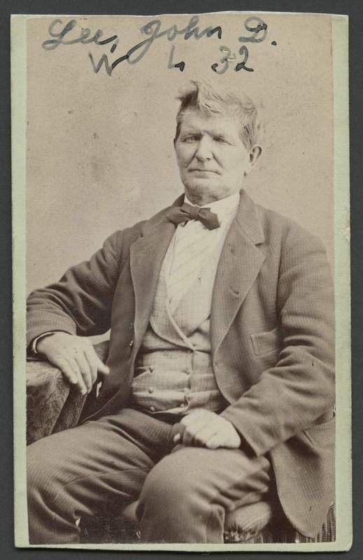
    <summary type="html"><![CDATA[<p><strong><em>The Fancher Party set out from Arkansas in April 1857, determined to reach the fertile fields of California- but they never reached their destination. Instead, they met their deaths at the hands of Mormon settlers and Paiute Indians near Mountain Meadows, an area just south of present day Cedar City, Utah on September 11, 1857. </em></strong></p><img src="https://www.intermountainhistories.org/files/fullsize/7681cb75268f4cde17eeec5e1d4a5372.jpg" alt="John D. Lee " /><br/><p>The mid-1850s relationship between Latter-day Saints (or Mormons) and the United States government, who felt that they were growing too powerful, was tense. In response to the growing power of the leaders of the LDS Church in Utah, the federal government sent a large Army to Utah in 1857 to assess the situation and suppress any potential rebellions against the United States. With the army's approach, fear and anxiety spread among Mormon settlers in Utah Territory.</p><p>It was in this atmosphere that the Fancher party crossed Utah Territory on their way to California. Contention abounded between the Fancher Party and the Mormon communities through which they passed on their journey west. The emigrants chided Mormon settlers that the army was coming to suppress the religious group, and boasted that members in their group had persecuted Joseph Smith, the Church’s first leader. Their threats to steal from Mormon communities further enraged the Saints, creating a climate that resulted in extra-legal vigilantism.</p><p>In response to the perceived threats, LDS leaders in Cedar City and Parowan took matters into their own hands. Isaac C. Haight, William Dame, and John D. Lee solicited the aid of local Paiute Indians to steal the settlers’ stock while the local community plotted to attack the emigrant train encamped at ‘the Meadows.’ Under the ruse of a white flag, Lee led the Indians in the raid.  Then, the local men disarmed the wagon train and killed around 120 emigrants on September 11, 1857. Only seventeen members of the party survived, all children too young to remember the attack. After the massacre, word came from Brigham Young in Salt Lake City for the Saints and the Paiutes to let the emigrant train pass unmolested.  Unfortunately, his letter came too late to save the emigrant party from disaster. Some debate Young's knowledge and timing of the letter.</p><p>A series of cover-up stories allowed those responsible for the massacre to escape prosecution for years. John D. Lee faced trial in 1875, though the court did little to address the situation. A second trial commenced in 1878.  This time the court attributed full responsibility for the massacre to Lee, ruling that his actions qualified as murder. The jury sentenced Lee to death and the federal representatives executed Lee on March 23, 1877.  The involvement and role of Paiute auxiliaries is still debated to the present. The other men responsible for the massacre escaped legal punishment. Most of the massacre survivors eventually rejoined relatives in Arkansas and California.  Representatives of the participants dedicated a memorial commemorating the tragedy and honoring the families who died at Mountain Meadows in 1999.</p><p><em><strong><a href="https://www.intermountainhistories.org/items/show/22">For more (including 5 images) view the original article</a></strong></em></p>]]></summary>
    <published>2017-02-15T17:21:51+00:00</published>
    <updated>2026-04-17T19:31:58+00:00</updated>
    <link rel="alternate" type="text/html" href="https://www.intermountainhistories.org/items/show/22"/>
    <id>https://www.intermountainhistories.org/items/show/22</id>
    <author>
      <name>Rachel Hendrickson, Brigham Young University </name>
    </author>
  </entry>
  <entry>
    <title type="html"><![CDATA[Reexamining the Bear River Massacre  ]]></title>
    <summary type="html"><![CDATA[<p><strong><em>January 29, 1863, dawned bright and cold. Encased in snow and silence, the Shoshone Indian camp located near the banks of Bear River near present-day Franklin, Idaho, had little idea what that fateful day held in store for them. In the early dawn hours, screams, gun smoke, and the feverish sounds of a pitched battle pierced the air. Within a few minutes, California militiamen had burned the Shoshones’ homes, shot their husbands and sons, raped and killed women, and blood stained the white snow, bringing immense sorrow and grief to the Shoshones. </em></strong></p><img src="https://www.intermountainhistories.org/files/fullsize/d3796127175afa2318b9c9a5b1ba1316.jpg" alt="Bear River Massacre site, looking east " /><br/><p>Colonel Patrick Edward Connor, upon hearing miner’s charges that Shoshones had stolen good and animals from them, had led his California Volunteers north from Fort Douglas in Utah Territory to Bear Hunter’s Shoshone village adjacent to the Bear River.  Connor, already antagonistic towards Indians and Mormons, had decided to attack the Indians in their winter encampment in order to participate in some form of military combat during the Civil War. </p><p>Connor’s men approached the Indian encampment early that morning. Upon seeing the approaching militia, the Indians quickly gathered up their weapons and the battle commenced. Once their ammunition ran out, the Indians asked to surrender, but received no mercy. The battle quickly turned into a massacre as the militia slaughtered 250 Shoshone men, women, and children while they California Volunteers suffered eighteen casualties. </p><p>At the sight of the confrontation, a national monument was to be erected, bearing the words “Battle of Bear River.” Mae T. Parry, a granddaughter of one of the chief Indians involved in the massacre, has begun to fight for the name of the Bear River Battle to be called the Bear River Massacre. “When you attack a sleeping village of Indian men, women and children, you can't call that a battle” Parry noted.  Her ongoing fight to right the wrongs of history reflects the ongoing struggles of her people against the American government and for the inclusion of Indian point-of-view into the national narrative. </p><p>In 2008 the Shoshone Nation acquired the site and commemorated the 150 year anniversary at the site in 2013. </p><p><em><strong><a href="https://www.intermountainhistories.org/items/show/23">For more (including 5 images) view the original article</a></strong></em></p>]]></summary>
    <published>2017-02-15T17:34:06+00:00</published>
    <updated>2026-04-17T19:31:58+00:00</updated>
    <link rel="alternate" type="text/html" href="https://www.intermountainhistories.org/items/show/23"/>
    <id>https://www.intermountainhistories.org/items/show/23</id>
    <author>
      <name>Kiya Mercado, Brigham Young University  </name>
    </author>
  </entry>
  <entry>
    <title type="html"><![CDATA[Colonel Patrick Edward Connor and the Bear River Massacre]]></title>
    <summary type="html"><![CDATA[<p><strong><em>On 29 January 1863 Colonel Patrick Edward Connor led a contingent of California militiamen against a Northwestern Shoshone village in present day Cache Valley, Idaho.  Connor and his men destroyed and burned the village, killing roughly 250 Indian men, women, and children over the space of four hours. The militiamen hopelessly outmatched the Northwestern Shoshone warriors who had only “bows and arrows, tomahawks, and a few rifles.”  Connor’s men, on the other hand, possessed 16,000 rounds of ammunition for their rifles and handguns, and additional ammunition for their mountain howitzers.  Historians refer to the events of this fateful day as the Bear River Massacre.</em></strong></p><img src="https://www.intermountainhistories.org/files/fullsize/b898db3530c02cc31fcbf5599aab4c2a.jpg" alt="Chief Sagwitch " /><br/><p> President Abraham Lincoln placed Connor in charge of the 3rd California Volunteer Infantry at the outbreak of the American Civil War in 1861. Fearing that the Confederates would try to isolate the newly formed state of California from the rest of the Union, Lincoln ordered Connor and his men to Salt Lake City to protect the overland mail routes from Indian attack. Incensed by this assignment, Connor pleaded with his superior officers to allow him to take his men east to fight in the main theater of the Civil War. He argued that the men under his command wanted to "serve their country in shooting traitors instead of eating rations and freezing to death around sage brush fires..." They longed for “the privilege of going to the Potomac and getting shot."  His request denied, he stayed in Utah Territory to protect the mail routes.  He ordered his men to construct Fort Douglas in Salt Lake City.</p><p>After two years without any military action, Connor instigated an opportunity to fight. The Northwestern Shoshone periodically traded with emigrant parties on the Oregon Trail, one of the primary routes under Connor’s protection, or defended themselves against unscrupulous miners traveling between Utah Territory and the future states of Idaho and Montana. Mormon settlement in Utah Territory and increased traffic along the Oregon Trail limited the resources available to the Northwestern Shoshone.  By the 1860s, the Shoshones had few choices but to exact a toll from emigrants and settlers utilizing Indian resources without compensating the tribe. Northwestern Shoshone warriors attacked a group of eight miners early in January 1863, killing two of them. The survivors made their way to Salt Lake City where they testified to Chief Justice John F. Kinney that Shoshones had attacked them. Kinney issued a warrant for the arrest of several Indian chiefs from the Northwestern Shoshone tribe including chiefs Bear Hunter, Sagwitch, and Sanpitch. The territorial marshal, Isaac L. Gibbs, recognizing that he would not be able to pursue and arrest the Shoshone chiefs by himself, requested the aid of Connor and his men.  Connor accepted enthusiastically. </p><p>Connor made it abundantly clear that because his superiors denied him the chance to fight Confederates in the South, he intended to fight Indian warriors instead. “Connor anticipated that a major fight with the Indians would give his bored troops an opportunity to exhibit their fighting prowess and might gain him new and more exciting appointments.”  He later admitted, “it was not my intention to take any prisoners.”  His expedition had nothing to do with protecting the overland mail routes, or arresting the Shoshone chiefs--he simply wanted a chance to fight but instead orchestrated a massacre.</p><p><em><strong><a href="https://www.intermountainhistories.org/items/show/24">For more (including 2 images) view the original article</a></strong></em></p>]]></summary>
    <published>2017-02-15T17:49:51+00:00</published>
    <updated>2026-04-17T19:31:58+00:00</updated>
    <link rel="alternate" type="text/html" href="https://www.intermountainhistories.org/items/show/24"/>
    <id>https://www.intermountainhistories.org/items/show/24</id>
    <author>
      <name>Erik Peterson, Brigham Young University </name>
    </author>
  </entry>
  <entry>
    <title type="html"><![CDATA[Camp Floyd and the Mormons]]></title>
    <summary type="html"><![CDATA[<p><strong><em>Driven from state to state, early coverts of The Church of Jesus Christ of Latter day Saints faced constant persecution for their religious beliefs in antebellum America.  Eventually, they fled west to the Rocky Mountains.  Within ten years, however, the federal government sent troops after them, fearing that Brigham Young, the Mormon prophet, was becoming too autonomous and powerful in the Utah Territory.  General Albert Johnston’s presence in the Utah Territory caused a great war of ideas—and sometimes arms—between the determined Saints and unsympathetic soldiers.  The establishment of Camp Floyd increased interactions between soldiers and Mormons and church leaders cautioned against the potential negative effects to the moral, social, and economic conditions on the Mormon Zion.</em></strong></p><img src="https://www.intermountainhistories.org/files/fullsize/8b854548a43b555632b0bbf8cffae768.jpg" alt="General Albert Sidney Johnston " /><br/><p>For nearly a decade prior to the army’s arrival in 1857, the Mormons had lived relatively isolated and undisturbed by outside influences. Of early concern to church leaders, Fairfield, a satellite town of Camp Floyd, was viewed as bringing moral decay to some Mormons.  Termed “Frogtown” by the Saints and army, it became a den of gambling houses, dance halls, brothels, and saloons frequented by soldiers, teamsters, emigrants, and even some settlers. Theft, prostitution, and murder frequently filled the streets and back halls. Church leaders mourned the spread of moral and social deterioration throughout the valley.  One member said, “Camp Floyd Fairfield was full of rotteness and evil of every description and I'm sorry to say our people of both sexes mixed up with them largely and of how bad it did look to see young ladies whose parents were faithful.”  </p><p>Despite the fear of moral and social turmoil that the army brought to Mormon communities, the Saints benefited economically from the army's occupation in the territory. The soldiers began building the immense fort at Camp Floyd as soon as they arrived. The fort consisted of buildings for headquarters, infantry and artillery units, storehouses, stables, corrals, workshops, powder magazines, a theatre, aqueduct, and so on. </p><p>At its height, Camp Floyd was perhaps the largest military installation in the United States prior to the Civil War. The Saints helped build the fort, laboring as artisans, carpenters, and mechanics, which allowed them to profit from trade with the army as Camp Floyd provided business opportunities for enterprising Saints. John Carson, for example, built the Stagecoach Inn, offering a simple yet comfortable environment for higher class visitors and military personnel alike. The inn later became an Overland Stage and Pony Express stop. </p><p>The commencement of the Civil War in 1861 struck the death knell for the army's military occupation in Utah Territory, and with it went a major source of conflict for the territory’s inhabitants. Johnston's army had opened the floodgates for travelers to pour into the territory, effectively ending the Mormons' isolation. Moral decay and social tension spread at an alarming rate from the camp to the Saints. Amidst all the social discord, however, the military presence had a positive impact on the territory's economy without which the Mormons would have struggled to keep their agricultural market afloat.  Conversely, the success of the fort depended upon Mormon laborers and consumers.  In the end, the Saints and Gentiles needed each other for Utah to grow and develop into a thriving territory.</p><p><em><strong><a href="https://www.intermountainhistories.org/items/show/25">For more (including 3 images) view the original article</a></strong></em></p>]]></summary>
    <published>2017-02-15T18:01:44+00:00</published>
    <updated>2026-04-17T19:31:58+00:00</updated>
    <link rel="alternate" type="text/html" href="https://www.intermountainhistories.org/items/show/25"/>
    <id>https://www.intermountainhistories.org/items/show/25</id>
    <author>
      <name>Lorin Groesbeck, Brigham Young University </name>
    </author>
  </entry>
  <entry>
    <title type="html"><![CDATA[Timpanogos Cave National Monument]]></title>
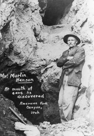
    <summary type="html"><![CDATA[<p><strong><em>Thousands of people climb to the top of Mount Timpanogos mountain every year, but many miss so-called the “heart” of the mountain, the Timpanogos Caves. </em></strong></p><img src="https://www.intermountainhistories.org/files/fullsize/8200d6bc26afa01231bf2211f467097d.jpg" alt="Martin Hansen stands at the natural entrance to Hansen Cave, which he discovered in 1887." /><br/><p>Settlers in Utah Valley discovered three separate caves in American Fork Canyon, seemingly undisturbed. Each cave is filled with exceptional varieties of stalactites, stalagmites, frostwork, flowstone, and other unique cave structures. The first of these caves was discovered in 1877 by logger Martin Hansen as he was cutting wood in the canyon. Mountain lion tracks near where he was working led to the entrance of a cave high up the canyon wall. His discovery came to be known as Hansen Cave. Inside the cave Martin discovered colorful and beautiful formations, which unfortunately were removed by visitors and miners over time. </p><p>The next cave, Timpanogos Cave, was not discovered until 1913. Two young men, James Gough and Frank Johnson, became bored while on a tour of Hansen Cave and went exploring. After becoming stuck and taking an alternate route back to their group, they stumbled upon an opening to another cave. This discovery was eventually lost after being covered by a landslide. Though the entrance was covered, rumors of its discovery were perpetuated by an article in the American Fork Citizen. In 1921, a group went to find it once again. Returning from the summit of Timpanogos, this group of friends decided to visit Hansen Cave in the hope of finding the new cave mentioned in the article. Surprisingly, they rediscovered the entrance to Timpanogos cave and subsequently formed the Payson Alpine Club dedicated to protecting the cave from the thieves and vandals that had destroyed Hansen Cave. </p><p>The last cave was discovered in 1921 by Heber Hansen and his nephew Wayne as they were hunting. While on the opposite side of the canyon, facing the two previously discovered caves, the pair spotted a potential third opening between the two other entrances. This third discovery eventually became known as Middle Cave. The three caves are now connected by tunnels to allow tour groups to pass through.  </p><p>When the people of Utah Valley began to recognize the significance of the caves and the potential for tourism, protecting the caves became a higher priority. Mining claims and previous land disputes threatened the existence of the three caves, and only through the valiant efforts of local citizens, and an appeal to the president of the United States, did it become possible to protect and establish these three caves as the national monument that they are today.</p><p><em><strong><a href="https://www.intermountainhistories.org/items/show/181">For more (including 7 images) view the original article</a></strong></em></p>]]></summary>
    <published>2018-05-25T23:41:53+00:00</published>
    <updated>2026-04-17T19:32:02+00:00</updated>
    <link rel="alternate" type="text/html" href="https://www.intermountainhistories.org/items/show/181"/>
    <id>https://www.intermountainhistories.org/items/show/181</id>
    <author>
      <name>Ellis Benson, Brigham Young University</name>
    </author>
  </entry>
  <entry>
    <title type="html"><![CDATA[Sego Canyon Fremont Culture Rock Art]]></title>
    <summary type="html"><![CDATA[<p><strong><em>Sego Canyon in Utah has rock art that dates back thousands of years. Four distinct time periods are represented in this collage of ancient artwork. </em></strong></p><img src="https://www.intermountainhistories.org/files/fullsize/3e11325fe3310d6ae0aa0d5b082a1295.jpg" alt="Sego Canyon Rock Art" /><br/><p>One of the most unique and easily accessible locations of ancient rock art in Utah is the Sego Canyon site near Thompson Springs in eastern Utah. Encompassing only three panels of rock art, four successive and distinct periods of human use are illustrated: Archaic, Fremont, Ute, and Anglo-American. Archaic, or Barrier Canyon style. The last of these styles may date as far back as 7000 BC and often features pictographs of large, rounded anthropomorphic figures. Fremont style paintings, dating from 600 AD to around 1250 AD, are pecked into the rock and depict angled anthropomorphic figures and abstract shapes. Ute style dates from 1300 AD to the mid-1800s and depicts animals, war figures, and shields painted in red and white. As American settlers arrived in the late nineteenth century, many sheepherders and cattlemen added their own additions to the artwork.</p><p>The site sits halfway between Thompson Springs, a center of ranching and railroading on the Denver & Rio Grande Western Railway, and the current ghost town of Sego, built to extract coal from the mines in the Book Cliffs first explored by Henry Ballard in 1881. G.K. Gilbert of the U.S. Geological Survey described the rock art in his 1883 report. In 1911, construction began on a railroad called the Ballard & Thompson Railway, which ran right in front of the largest of the three panels. After decades of vandalism by railroaders, miners, and ranchers, including a period where the cliff face was quarried out for building-stone, the BLM acquired the site in 1988. A restoration effort began in 1993 wherein they removed modern graffiti and patched the bullet holes to make the panels more visible.</p><p><em><strong><a href="https://www.intermountainhistories.org/items/show/182">For more (including 2 images) view the original article</a></strong></em></p>]]></summary>
    <published>2018-05-26T00:16:38+00:00</published>
    <updated>2026-04-17T19:32:02+00:00</updated>
    <link rel="alternate" type="text/html" href="https://www.intermountainhistories.org/items/show/182"/>
    <id>https://www.intermountainhistories.org/items/show/182</id>
    <author>
      <name>Joshua Bernhard, Brigham Young University</name>
    </author>
  </entry>
  <entry>
    <title type="html"><![CDATA[Great Falls of the Missouri River: When they found the Great Falls of the Missouri in June 1805, Lewis and Clark were relieved to be on the right path, but faced a difficult portage over the feature.]]></title>
    <summary type="html"><![CDATA[<img src="https://www.intermountainhistories.org/files/fullsize/3aefe050f1e709328e0fbba870599870.jpg" alt="Great Falls of the Missouri" /><br/><p>The Corps of Discovery relied heavily upon the geographic knowledge of Native peoples. They had been told of a set of impassable waterfalls high up on the Missouri River and finding them would indicate they were on the correct. However, in the late Spring of 1805, they reached a confusing confluence of two large rivers. Their Native informants had not mentioned such a large tributary - the Marias. The existence of this river puzzled the captains, who were unsure which river was the Missouri since the Marias matched it in size. Knowing the optimal months for travel were quickly passing, the captains spent a week on the decision, carefully evaluating each option knowing that a wrong choice would be costly. Eventually, Lewis and some men traveled up the Missouri where, to Lewis’ delight, they came across the Great Falls in June 1805. Lewis sent a message to Clark labeled “from the Great falls of the Missouri,” and Clark and his men rejoined the group.</p><p>Confident of their path, the captains believed the next portion of their journey to be easy, but they would find their information from Natives again incorrect. Although they had told Lewis and Clark “that the portage around the falls was not more than a half mile, the actual portage proved to be a torturous, eighteen-mile traverse that consumed more than a month of travelling season already far gone.” The water route was almost impossible to travel, forcing the group to continuously go on shore and walk, carrying their belongings. They encountered grizzly bears, rattlesnakes, and mosquitos, which created various problems and hardships for them. Eventually, they made it through the Great Falls and crossed the Missouri River, traveling onward to the west coast of the continent. </p><p>Today, Great Falls has a Lewis and Clark National Historic Trail Interpretive Center where visitors can learn more about the expedition, participate in activities that the Corps would have done, and learn about the plants and animals Lewis and Clark documented during their journey through the Falls.</p><p><em><strong><a href="https://www.intermountainhistories.org/items/show/183">For more (including 3 images) view the original article</a></strong></em></p>]]></summary>
    <published>2018-05-26T03:14:38+00:00</published>
    <updated>2026-04-17T19:32:02+00:00</updated>
    <link rel="alternate" type="text/html" href="https://www.intermountainhistories.org/items/show/183"/>
    <id>https://www.intermountainhistories.org/items/show/183</id>
    <author>
      <name>Kelsey Cogswell, Brigham Young University</name>
    </author>
  </entry>
  <entry>
    <title type="html"><![CDATA[Navajo Long Walk to Bosque Redondo]]></title>
    <summary type="html"><![CDATA[<p><strong><em>The forced relocation of Navajo to Fort Sumner in the 1860s was a time of loss and sorrow. The United States government was unable to support the large number of people forced out of their homes. </em></strong></p><img src="https://www.intermountainhistories.org/files/fullsize/14772910caae170413410284c32f8787.jpg" alt="[Untitled]" /><br/><p>From 1864 to 1868, the Navajos were forced to live at Fort Sumner on the Bosque Redondo reservation in eastern New Mexico, approximately 300 miles from their homeland. Around 8,000 Navajos were forced to make the journey. Hundreds, including the elderly and children, died on the way. Many more died during the four years at Bosque Redondo. </p><p>Navajo homelands cover northeast Arizona, northwest New Mexico, southeast Utah, and southwest Colorado. Their home, which they call Dinétah, is bordered by the four sacred mountains. Leading up to the Long Walk, the Navajos had difficult relations with the United States Army. This included broken treaties, the Army not protecting the Navajos from other raiding tribes, and some Navajos raiding the soldiers. Because of these raids, the military leader of New Mexico, James H. Carleton, wanted to control the Navajos. Carleton’s other motives were to assimilate the Navajos into an agricultural and Christian lifestyle. He also wanted their land for silver and gold mining. He gave the Navajos a chance to surrender but none did. He received help from Christopher “Kit” Carson, who eventually got the Navajos to abandon their land after burning and destroying everything they had. The majority surrendered, but others hid from and fought the soldiers. </p><p>In spring of 1864, the Navajos were forced to journey to Bosque Redondo. They did not know where they were going, how far they would travel, or how long the trip would last. They were not prepared for such a journey. Those who could not keep up were left behind. Fort Sumner was not big enough for the large number of Navajos plus the Mescalero Apaches that were also relocated there. Inadequate amounts of food and supplies caused near starvation. When they were given food, it was spoiled or they did not know how to prepare it. Crops that the Navajos grew failed greatly each year. Carleton’s experiment was unsuccessful.</p><p>On June 1, 1868, the Treaty of Bosque Redondo was signed by the United States Government and Navajo leaders. The treaty allowed them to return to their traditional homeland. They were granted “$150,000 for rehabilitation, plus 15,000 sheep and goats and 500 head of cattle, as well as token payments to each tribal member.” Part of the treaty included sending the children and future generations to government boarding schools where their cultural identity was stripped from them. The last of these schools closed in the 1980s.</p><p>The tragedy of the Long Walk is still evident in the culture and attitudes of the Navajo. While it is difficult for them to reflect upon, they remember the strength of their ancestors that led to the continuation of their people. </p><p><em><strong><a href="https://www.intermountainhistories.org/items/show/184">For more (including 3 images) view the original article</a></strong></em></p>]]></summary>
    <published>2018-05-26T03:56:33+00:00</published>
    <updated>2026-04-17T19:32:02+00:00</updated>
    <link rel="alternate" type="text/html" href="https://www.intermountainhistories.org/items/show/184"/>
    <id>https://www.intermountainhistories.org/items/show/184</id>
    <author>
      <name>Cherie Elise Gutierrez, Brigham Young University</name>
    </author>
  </entry>
  <entry>
    <title type="html"><![CDATA[Étienne Provost in Utah Valley<br />
]]></title>
    <summary type="html"><![CDATA[<p><strong><em>Étienne Provost is the namesake of the Provo river and the modern day city of Provo.</em></strong></p><img src="https://www.intermountainhistories.org/files/fullsize/2803860c347c0865516563ef6435f201.jpg" alt="Éntienne Provost" /><br/><p>Born in Canada in 1785, French-Canadian Étienne Provost moved west as a young man to pursue the life of a fur trader. Although he is recognized as one of the most influential mountain men during his time, his legacy hides in the shadows of more recognizable men, such as Jim Bridger. This portly, illiterate, self-made fur trader led expeditions and ventures through modern-day New Mexico and Utah before settling in Missouri. His influence lies within his namesake: Provo, Utah. </p><p>During his 1824 travels, Provost encountered some Shoshones between Utah Lake and the Great Salt Lake. Warren Angus Ferris, another trapper, included a version of their meeting in his writings, although he was not present at the time. He writes about an Indian “evil genius” known as “Bad Gocha” (an Anglicized version of the French nickname “mauvais gauche” or “the bad left-handed one”) who met with Provost. He asked Provost to smoke the peace pipe but requested that all metals be removed, as it would be problematic for the ritual. As the white men complied, the “Indians fell upon them and commenced their work of slaughter with their knives,” resulting in about fifteen dead. However, it should be noted that the number and story varies between accounts. The most likely estimate is that about eight died. Provost’s escape led to the renaming of the nearby Timpanoquint River to the phonetically spelled Provo. Later, when Mormon settlers moved into the area, the nearby city became Provo as well, although Provost likely never knew of either of his namesake landmarks. </p><p>While this story paints a picture of an unprovoked attack by ruthless, violent Indians, Peter Skene Ogden made a point of explanation when writing about the event. He noted that, not long before Provost’s company came, another group of white mountain men forcibly took horses and furs from the same group of Shoshone that resulted in a death of a Native American. Although there is not a record of a Shoshone perspective, this information helps to create a more relatable, human image instead of perpetuating the myth of the aggressive Indian. </p><p><em><strong><a href="https://www.intermountainhistories.org/items/show/185">For more (including 4 images) view the original article</a></strong></em></p>]]></summary>
    <published>2018-05-28T15:27:22+00:00</published>
    <updated>2026-04-17T19:32:02+00:00</updated>
    <link rel="alternate" type="text/html" href="https://www.intermountainhistories.org/items/show/185"/>
    <id>https://www.intermountainhistories.org/items/show/185</id>
    <author>
      <name>Rachel Felt, Brigham Young University</name>
    </author>
  </entry>
  <entry>
    <title type="html"><![CDATA[The Battle of the Little Bighorn]]></title>
    <summary type="html"><![CDATA[<p><strong><em>At the Battle of the Little Bighorn (or Battle of Greasy Grass) Lakota, Northern Cheyenne, and Arapahos defeated U.S. Army General George Armstrong Custer. Though they won the battle, the Natives eventually surrendered to relocation and reservation confinement.</em></strong></p><img src="https://www.intermountainhistories.org/files/fullsize/da952bfc060ae3d8448a8814e5394d7b.jpg" alt="Custer&#039;s Last Stand" /><br/><p>Lakota Sioux have lived in the present-day South Dakota area for centuries. The first reservation treaty between the Lakota and the United States was signed in 1851 when Europeans on the Oregon Trail started to cross the southern part of Lakota lands in large numbers. There were several clashes between whites and Lakotas after that, but the biggest and the most famous conflict happened in 1876 when several hundred U.S. soldiers were killed by Lakota, Northern Cheyenne, and Arapaho forces at the Battle of the Little Bighorn.</p><p>By the 1870s, many Plains Natives had moved onto government agencies in Nebraska and South Dakota. However, in 1875, after discovering gold in the Black Hills on Lakota land, and anxious to civilize the buffalo-chasing nomads, the United States ordered the rest of the tribe to move or be punished. Move was something Sitting Bull, a well-known Lakota chief, could not do. For the previous ten years, Sitting Bull had pushed his people to reject the restrictions of agency life, which fought against Lakota religion, language, and tribal organization. In 1876, he started gathering Lakota, as well as their Cheyenne allies, into a huge moving village in southeast Montana far away from the agencies.</p><p>Angry at Sitting Bull’s defiance, President Ulysses Grant sent an army led by General Terry to march to Sitting Bull’s camp and force him to obey. Terry decided to split his army in half: the half led by him would attack from downriver with the help of a riverboat while the half led by General Custer would attack from upriver. Custer was impatient, started his attack early, and was overpowered by the superior numbers and fighting experience of the Lakota and Cheyenne warriors in the village. Of the 650 soldiers in Custer’s army, 268 of them were killed, including all of the soldiers who were fighting beside Custer at the time. The survivors managed to hide in a thrown-together fort until they were saved two days later by Terry’s army (who saw no action). The mission was a complete failure.</p><p>For the US, the battle was a terrible shock and Custer was turned into an American hero, like Abraham Lincoln or George Patten. For the Lakota, it was the happy fulfillment of Sitting Bull’s vision of a strong Lakota nation, free from American laws and land grabs. Over the next winter, however, bad weather exhausted the Lakota, and in 1877 they gave up the fight and moved to Nebraska. General Custer kept his hero status until the 1960s and 70s when Native American culture and history started to become more accepted and Custer was seen more and more as a villain who oppressed a nature-loving society. Today, the Battle of the Little Bighorn is still alive in the memories of both natives and non-natives as the moment in history when Indians proved that, despite what most whites believed, they were still very much a force to be reckoned with.</p><p><em><strong><a href="https://www.intermountainhistories.org/items/show/186">For more (including 3 images) view the original article</a></strong></em></p>]]></summary>
    <published>2018-05-28T16:48:13+00:00</published>
    <updated>2026-04-17T19:32:02+00:00</updated>
    <link rel="alternate" type="text/html" href="https://www.intermountainhistories.org/items/show/186"/>
    <id>https://www.intermountainhistories.org/items/show/186</id>
    <author>
      <name>Jonathan Reil, Brigham Young University</name>
    </author>
  </entry>
  <entry>
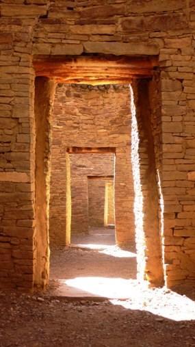
    <title type="html"><![CDATA[Chaco Canyon Overview]]></title>
    <summary type="html"><![CDATA[<p><strong><em>Chaco Canyon bears evidence of a civilization that flourished between 9000 BC and 1300 AD.</em></strong></p><img src="https://www.intermountainhistories.org/files/fullsize/c8cb5ba557401e1c945009b3c16dbffe.jpg" alt="Doorways at Pueblo Bonito" /><br/><p>Chaco Canyon National Park is located in northwestern New Mexico. The area is open to the public to learn about the people who lived within the walls of Chaco Canyon thousands of years ago. In 9000 BC, the area was occupied by Paleo Indians and Archaic peoples. It was then occupied by Ancestral Puebloans from 1 AD to 1300 AD. Between 750 and 850 AD, much of the population of the central San Juan Basin moved to the Four Corners area, north of the San Juan River. Over 1.5 million artifacts have been documented from Chaco Canyon. In the middle of the New Mexico desert, Chaco Canyon housed hundreds of prehistoric peoples. </p><p>Early archaeologists recognized two types of structures and identified them as “great pitstructures” and “great kivas”. These structures “may represent two ways of organizing ritual, or perhaps even two ethnicities.” </p><p>Chaco Canyon was pre-planned rather than annexed; the roads were laid out in straight lines and astronomical orientation would have necessitated a certain amount of planning, skill, and leadership. People lived in the canyon in eleven “great houses”, each one of them big enough to provide homes for an entire village. Inside the great houses, there are approximately 1,133 rooms, and the average size of 1,133 rooms at Chacoan buildings is 11. 97 meters squared. </p><p>Chaco Canyon is evidence of a civilization that flourished between the ninth century BC and thirteenth century AD and attained remarkable achievements in architecture, agriculture, social complexity, engineering, astronomy, and economic organization. </p><p><em><strong><a href="https://www.intermountainhistories.org/items/show/187">For more (including 2 images) view the original article</a></strong></em></p>]]></summary>
    <published>2018-05-28T17:18:16+00:00</published>
    <updated>2026-04-17T19:32:02+00:00</updated>
    <link rel="alternate" type="text/html" href="https://www.intermountainhistories.org/items/show/187"/>
    <id>https://www.intermountainhistories.org/items/show/187</id>
    <author>
      <name>Erin Tapahe, Brigham Young University</name>
    </author>
  </entry>
  <entry>
    <title type="html"><![CDATA[Chief Sagwitch Timbimboo]]></title>
    <summary type="html"><![CDATA[<p><strong><em>In the mid- to late-1800s, when the Mormon pioneers came to the Utah territory they found the land its resources already occupied and used by various groups of Utes, Paiutes, Northwestern Shoshones, Goshutes, and Navajos. For Northwestern Shoshones, Cheif Sagwitch Timbimboo stood as a beacon for his people to follow during these early years of encounter, conflict, and negotiation.</em></strong></p><img src="https://www.intermountainhistories.org/files/fullsize/9106de5c009228b8c120e4591bf5beca.jpg" alt="Sagwitch Timbimboo" /><br/><p>Chief Sagwitch was born in 1822. As a boy, he honed his skills as a hunter and a speaker. He spent time with fur trappers and was well suited to be chief.  Sagwitch was already a chief of the Northwestern Shoshone by the age of twenty-five when Mormons settlers came to the Utah territory. Sagwitch met the new leader of the Church of Jesus Christ of Latter-day Saints, Brigham Young, and welcomed him and the rest of the Mormons into the area.</p><p>Sagwitch became friends with Brigham Young and did what he could to keep the peace between the Shoshone and the Mormons/settlers. Tensions grew and in January of 1863, Colonel Conners of the U.S. Army took his men and attacked the Shoshone who had camped at the Bear River for winter. Chief Sagwitch’s group was among them and was one of the few survivors. Sagwitch sought help for his people from Brigham Young and found aid from the Mormon Church, which Sagwitch later joined in 1875.</p><p><em><strong><a href="https://www.intermountainhistories.org/items/show/188">For more (including 2 images) view the original article</a></strong></em></p>]]></summary>
    <published>2018-05-30T19:34:26+00:00</published>
    <updated>2026-04-17T19:32:02+00:00</updated>
    <link rel="alternate" type="text/html" href="https://www.intermountainhistories.org/items/show/188"/>
    <id>https://www.intermountainhistories.org/items/show/188</id>
    <author>
      <name>Spencer Thomas, Brigham Young University</name>
    </author>
  </entry>
  <entry>
    <title type="html"><![CDATA[The Golden Spike: Promontory Summit and the Transcontinental Railroad]]></title>
    <summary type="html"><![CDATA[<img src="https://www.intermountainhistories.org/files/fullsize/3de2b2ada80702b84f11d853b1a6cc5f.jpg" alt="Joining of the Rails, Promontory Point; May 10, 1869" /><br/><p>Western settlers longed for a faster and easier way to travel across the West. Emigrants traveling by horseback, wagon, or foot required several months to cross the plains and the Rocky Mountains. Trains made travel faster, safer, and much less physically taxing, but there was no transcontinental railroad that connected the country from east to west in the mid-nineteenth century. Technology and political incentives made it feasible for the country to contemplate a transcontinental railroad. </p><p>By the late nineteenth century, the transcontinental railroad came to fruition.  The Union Pacific and Central Pacific Railroad companies laid hundreds of miles of tracks, but needed a place to connect. On April 8, 1869, Grenville M. Dodge, chief engineer of the Union Pacific, along with Collis Potter Huntington, president of the Central Pacific, met with Congressman Sam Hooper to settle the debate of where the two railroads would meet. Together they concluded on Promontory Summit, “at which place the rails shall meet and connect and form one continuous line.” </p><p>Located in Utah, Promontory Summit (also referred to as Promontory Point) is an area of high ground northwest of Salt Lake City. Here, at Promontory Summit, on May 10, 1869, three spikes were driven into the ground to commemorate the completion of the transcontinental railroad. The spikes symbolized different areas of the country coming together, like the different railroads that came together. The most famous spike, the golden spike, was made from California gold, the silver spike from Nevada alloy silver, and the iron spike from a combination of Arizona metals, connecting these Western states permanently in one symbolic tie of the railroad.</p><p>A crowd of up to 1,000 people gathered at Promontory Summit on May 10, 1869 to witness the historic day when the railroads joined together as one. The Deseret News reported, “A thousand throbbing hearts impulsively beat to the motion of the trains as the front locomotive of each company led on majestically up to the very verge of the narrow break between the lines, where, in a few moments, was to be consummated the nuptial rites uniting the gorgeous east and the imperial west of America, with the indissoluble seal of inter-oceanic commerce.” </p><p>Today, Promontory Summit, forever tied to the railroad, houses a Visitor Center and Engine House where people can experience the history of the transcontinental railroad.</p><p><em><strong><a href="https://www.intermountainhistories.org/items/show/189">For more (including 2 images) view the original article</a></strong></em></p>]]></summary>
    <published>2018-05-30T20:21:58+00:00</published>
    <updated>2026-04-17T19:32:02+00:00</updated>
    <link rel="alternate" type="text/html" href="https://www.intermountainhistories.org/items/show/189"/>
    <id>https://www.intermountainhistories.org/items/show/189</id>
    <author>
      <name>Emma Tolman, Brigham Young University</name>
    </author>
  </entry>
  <entry>
    <title type="html"><![CDATA[The Sacred Heart Mission and “Benign” Cultural Colonization]]></title>
    <summary type="html"><![CDATA[<p><strong><em>Father Pierre De Smet, the Jesuit missionary andexplorer of the American West, described the Coeur d’Alene Indians upon his first encounter with them in 1842 as extremely receptive to his Christian message. De Smet baptized twenty-four adults and many small children among the Coeur D’Alene people during that first visit. De Smet left after a few days, but sent his Jesuit colleagues later that same year to stay with the Indians over the winter and to establish a Catholic mission among them. </em></strong></p><img src="https://www.intermountainhistories.org/files/fullsize/bf0ddf4513ac8914118251c80462fbe1.jpg" alt="Sacred Heart Mission" /><br/><p>Father Anthony Ravalli, a Jesuit missionary and architect from Italy, designed and led the construction of the Church of the Sacred Heart from 1850–53, and the Coeur D’Alene people provided much of the labor necessary to complete the project. Father De Smet’s later writings contain numerous references to the Sacred Heart mission, and he often stayed there during his travels between missions. </p><p>On one occasion in 1863, Father De Smet stayed at the mission for six days and wrote about the changes occurring with the growing presence of white miners and settlers. He referenced a report by a U.S. Army captain that claimed that the only “salvation” for Indians would be “to be removed far, far from [the] presence [of the whites]” and that Indians “can never exist in contact with whites.” Father De Smet himself condemned this suggestion of removal and wrote, “May heaven preserve [the Coeur d’Alene Indians] from contact with the whites!” His advocacy for Indians, however, was predicated mainly on their conversion and faithfulness to Christianity.</p><p>The legacy of Pierre De Smet and his Jesuit missions, including Sacred Heart, is a subject of debate in the current postcolonial era. Traditionalist historians and biographers generally portray Father De Smet as a heroic explorer and a savior to the native peoples of western North America, specifically one who sought to understand and honor native culture. However, as theologian George E. Tinker writes, “Any Euroamerican’s understanding of or appreciation for Indian cultures was subject to severe cultural limitations.” Pierre De Smet may have tried to understand Indian culture, but ultimately the Jesuit approach was to quickly “impose European cultural values.” De Smet himself actively sought to use his missions to reorganize Indian civilization into a sedentary society that could better receive Christianity. So while De Smet himself was not directly involved in the removal and extermination of Indians (in fact he spoke against it), the cultural colonization of which he was a part was aimed at eroding Indian identity and culture. The Mission of the Sacred Heart, like other colonialist European or American religious ventures, should be viewed as a tool of western imperialism. </p><p><em><strong><a href="https://www.intermountainhistories.org/items/show/190">For more (including 3 images) view the original article</a></strong></em></p>]]></summary>
    <published>2018-05-30T20:55:05+00:00</published>
    <updated>2026-04-17T19:32:02+00:00</updated>
    <link rel="alternate" type="text/html" href="https://www.intermountainhistories.org/items/show/190"/>
    <id>https://www.intermountainhistories.org/items/show/190</id>
    <author>
      <name>Sam Utley, Brigham Young University</name>
    </author>
  </entry>
  <entry>
    <title type="html"><![CDATA[The Navajo Trail of Tears from Fort Defiance to Bosque Redondo]]></title>
    <summary type="html"><![CDATA[<img src="https://www.intermountainhistories.org/files/fullsize/0fcb145b9ba89e523a3cc8089c2d528f.jpg" alt="Navajos Under Guard After Forced March to Fort Sumner, New Mexico, ca. 1864" /><br/><p>The Long Walk is to the Navajo what the Trail of Tears is to the Cherokee. Troubled relations between the U.S. and the Navajos brought on a wicked removal in December of 1863. Earlier in the year, the United States government had sent in Christopher “Kit” Carson to remove the Navajos from their homeland of Fort Sumner, New Mexico. He burned their villages, starved them, and took them as slaves until they surrendered in the middle of winter, the worst time to begin a 400+ mile journey from points in Navajo country to Fort Defiance, Arizona and from there to Fort Sumner, New Mexico.</p><p>Cold made the difficult journey worse, but the Navajos suffered the most spiritually and mentally because they were uprooted from their homeland. They called their home The Four Sacred Mountains due to the spiritual qualities it possessed for them. Their hardships resulted in the death of around 200 Navajos on the journey. Some died from their conditions. Others were shot for being pregnant, old, or slow. The Navajos were not allowed to bury their dead.</p><p>More than 8,000 Navajos made it to Fort Sumner where they experienced continued starvation, slavery, prostitution, and disease at the hands of their enemy. It is estimated that more than 3,000 Navajos died at Fort Sumner by 1868. That spring, General Sherman of the United States of America sent a survey report back to the government and reported only 7,111 Navajo survived at Fort Defiance, and that he was convinced, “that the Navajos [would] never be contented to remain” at any place other than their homeland. On August 28, President Andrew Johnson signed a treaty that allowed the Navajo to return to their home at Fort Defiance.</p><p>One Navajo woman said, “When I tell my grandchildren about the Long Walk, they don’t believe me. I tell them that they wouldn’t be as they are today if their ancestors hadn’t gone through the confinement and even died of hunger.” The Navajos are proud of their ancestors for being strong and surviving against the odds. They recognize that this type of horrible event should never happen again.</p><p><em><strong><a href="https://www.intermountainhistories.org/items/show/191">For more (including 3 images) view the original article</a></strong></em></p>]]></summary>
    <published>2018-05-31T00:31:34+00:00</published>
    <updated>2026-04-17T19:32:02+00:00</updated>
    <link rel="alternate" type="text/html" href="https://www.intermountainhistories.org/items/show/191"/>
    <id>https://www.intermountainhistories.org/items/show/191</id>
    <author>
      <name>Maddie Pettit, Brigham Young University</name>
    </author>
  </entry>
  <entry>
    <title type="html"><![CDATA[The Intermountain Indian School]]></title>
    <summary type="html"><![CDATA[<p><strong><em>Between WWII and 1985, the Bureau of Indian Affairs used the Bushnell Army Hospital to assimilate Native American students. Tribal animosities and civil-right abuses lead to riots. </em></strong></p><img src="https://www.intermountainhistories.org/files/fullsize/90565add19e26c7f56a8867a4203ab0f.jpg" alt="Class of 1972" /><br/><p>Following WWII, the Bureau of Indian Affairs (BIA) converted the Bushnell Army Hospital—a multi-million dollar military facility—into a federally operated Indian Boarding School. Nestled up against the Wasatch Mountains in Brigham City, Utah, the Intermountain Indian School (IIS) became home to an annual 2,150 students, ages six to twenty-two, 600 of which spoke no English upon arrival. The IIS quickly became the largest of the remaining nineteen off-reservation boarding schools operated by the BIA in both size and number of students.</p><p>As with past models, the IIS emphasized English and other academic and vocational skills and prescribed the age-old practice of assimilating Indians into mainstream America—a type of education for extinction. In 1951, IIS superintendent George Boyce, in hopes of permanently removing Navajo children from their Indigenous cultures and communities, proudly announced that the IIS would approach assimilation of “these backward groups” through “a more informed attack” in order to Americanize the Navajo children that attended the school.</p><p>In the fall of 1974, they renamed the school the Intermountain Inter-Tribal School, choosing to enroll students from twenty-six other tribes from across the nation. Because of tribal animosities, riots erupted in February 1975, during which three police officers were injured and several police cars destroyed. Further, operating under conflict of constitutional and federal treaty requirements, the IIS was charged with numerous civil-rights lawsuits that described a number of personal abuses and violations of human rights. On May 17, 1984, the Intermountain Indian School closed its doors, ending over a century of federally-instituted American Indian boarding school programs.</p><p><em><strong><a href="https://www.intermountainhistories.org/items/show/192">For more (including 4 images) view the original article</a></strong></em></p>]]></summary>
    <published>2018-05-31T16:26:03+00:00</published>
    <updated>2026-04-17T19:32:02+00:00</updated>
    <link rel="alternate" type="text/html" href="https://www.intermountainhistories.org/items/show/192"/>
    <id>https://www.intermountainhistories.org/items/show/192</id>
    <author>
      <name>Terence Wride, Brigham Young University</name>
    </author>
  </entry>
  <entry>
    <title type="html"><![CDATA[Veterans of Indian Wars Memorial: While the statue atop the Veterans of Indian Wars Memorial in Provo is rumored to be a mass-produced Union soldier, it was actually carved by a local artist. ]]></title>
    <summary type="html"><![CDATA[<img src="https://www.intermountainhistories.org/files/fullsize/098bc07643f98611856fd3731515ad04.jpg" alt="The Veterans of Indian Wars Memorial" /><br/><p>The Veterans of Indian Wars Memorial, located on the southwest corner of the intersection of 500 West and Center Street in Provo, UT, was constructed by the Sons of the Utah Pioneers and unveiled July 24, 1909.  The memorial is dedicated to the original settlers of Provo and residents who fought in Utah's Indian Wars from 1850 to 1868. These wars included the Walker War, the Battle of Provo River, and other conflicts. The northeast plaque lists twenty-eight individuals and thirteen families as original settlers of Provo in 1849. The southeast, southwest, and northwest plaques list 121 veterans of the Indian Wars. </p><p>There is a story in circulation that a New England company mass produced stock Civil War memorial statues in 1908 in preparation for the fiftieth anniversary of the war in 1911 and that the statue on top of the Provo Indian Wars Memorial is one of these (a statue of a Union soldier).  However, this rumor is untrue. "Victory," the statue that rests atop the memorial, was sculpted by Cyrus Edwin Dallin, renowned sculptor, native of Springville, and creator of The Angel Moroni statue that was placed on the LDS Salt Lake Temple spire.</p><p><em><strong><a href="https://www.intermountainhistories.org/items/show/193">For more (including 7 images) view the original article</a></strong></em></p>]]></summary>
    <published>2018-05-31T18:15:07+00:00</published>
    <updated>2026-04-17T19:32:02+00:00</updated>
    <link rel="alternate" type="text/html" href="https://www.intermountainhistories.org/items/show/193"/>
    <id>https://www.intermountainhistories.org/items/show/193</id>
    <author>
      <name>Jerron Orton, Brigham Young University</name>
    </author>
  </entry>
  <entry>
    <title type="html"><![CDATA[The Rock Springs Massacre of 1885 <br />
]]></title>
    <summary type="html"><![CDATA[<p><strong><em>In Rock Springs, Wyoming a fatal display of jealously and racism took place against Chinese immigrants on September 2, 1885. </p></strong></p><img src="https://www.intermountainhistories.org/files/fullsize/4813f8fd04b20abf1d38258622e59ced.jpg" alt="Rock Springs Massacre" /><br/><p>The first large wave of Chinese immigrated to California in 1848 in search of gold. The Chinese labored in mines and railroads. Companies loved Chinese laborers because they worked longer hours than their white counterparts and for less pay. Many white laborers in the West felt threatened by the Chinese laborers because of the lower wages and poorer conditions they worked for. The Chinese laborers experienced discriminated in political, social, and economic life. Some examples of this discrimination include denied citizenship, negative social stereotypes, and lower wages.  </p><p>In 1882 the United States Congress passed the Chinese Exclusion Act, which prohibited Chinese from entering the United States. It did not directly impact those immigrants already in America although violence and discrimination towards Chinese increased. </p><p>One of the notorious atrocities occurred in Rock Springs, Wyoming in 1885. Over 600 Chinese lived there with 250 white workers at the mine run by the Union Pacific Railroad. White laborers had tried to unionize to protect wages but the Chinese laborers did not unionize with them. On the morning of September 2, 1885, a fight broke out between Chinese and Caucasian miners. The white workers went to town and rallied people together to go and attack the China town portion of Rock Springs across Bitter Creek. The mob gave the Chinese an hour to leave but the mob attacked a half hour after the warning. They burned all the homes in Chinatown, killed twenty-eight Chinese laborers and injured fourteen more as a direct result of the massacre. </p><p>In Wyoming Territory, Governor Francis F. Warren telegraphed President Grover Cleveland on September 7, 1885, asking for federal troops to come to the aid of Wyoming to help control the mob telling him that the mob would not allow the Chinese to return to the city. The president commanded the army to protect the Chinese laborers and they went back to the mines with the guaranteed protection of the army. None of the murderers were prosecuted. The white laborers felt as though the federal government, in protecting the Chinese, enabled and upheld a type of slavery that negatively impacted their ability to compete. This incident served as catalyst for other anti-Chinese race riots that occurred throughout the United States. </p><p><em><strong><a href="https://www.intermountainhistories.org/items/show/276">For more (including 4 images) view the original article</a></strong></em></p>]]></summary>
    <published>2019-02-09T04:16:46+00:00</published>
    <updated>2026-04-17T19:32:04+00:00</updated>
    <link rel="alternate" type="text/html" href="https://www.intermountainhistories.org/items/show/276"/>
    <id>https://www.intermountainhistories.org/items/show/276</id>
    <author>
      <name>Sarah Adams, Brigham Young University</name>
    </author>
  </entry>
  <entry>
    <title type="html"><![CDATA[ Sitting Bull and the Sun Dance of 1876<br />
]]></title>
    <summary type="html"><![CDATA[<p><strong><em>Sitting Bull influenced many events in the nineteenth century through his roles as Medicine Man and War Chief. The Sun Dance he performed in June of 1876 along the Rosebud River raised the hopes of the Lakota tribes, and predicted the victory at the Battle of the Little Bighorn.</p></strong></p><img src="https://www.intermountainhistories.org/files/fullsize/2614227e05cae714a0b428df29c9c73c.jpg" alt="Sitting Bull, 1885" /><br/><p>In 1876, Hunkpapa Medicine Man and War Chief, Sitting Bull, worried about the eminent war between the seven tribes of the Lakota Nation and the Americans. Because of his religious devotion and belief in a connection with his ancestors, he participated in the annual Sun Dance to purify his heart and provide his people with power. In the Sun Dance, an annual religious ritual performed by many Plains Indian tribes, dancers prayed to the Great Spirit and inflicted physical pain on themselves in order to reach a higher spiritual realm and to benefit the well-being of the tribe. On June 6, 1876, Sitting Bull performed this ritual in the Rosebud River Valley, where the Hunkpapas camped for several days before moving to the site where the Battle of the Little Bighorn took place. This year’s ritual became so important people referred to it as “Sitting Bull’s Sun Dance” in his honor. Sitting Bull, in this specific instance, offered one hundred pieces of flesh from his arms as a sacrifice. He danced throughout the night until he fainted from a loss of blood. When he awoke, he had startling news to tell his friends and family. He had a vision of soldiers attacking an Indian village, but they and their horses were upside down in the camp with their feet towards the sky. The Indians interpreted this vision as an indication of their victory over the soldiers. This gave the Indians peace and hope that their warriors would defeat and kill the soldiers. </p><p>Sitting Bull’s vision of soldiers falling into their village materialized in June 1876 at the Lakota encampment along the Greasy Grass river. His vision also bolstered their confidence in meeting and destroying General George Armstrong Custer’s 7th Calvary at the Battle of the Little Bighorn. Sitting Bull’s religiosity led him to experience a hopeful vision which increased morale, aided in the Lakota’s defeat of Custer and his troops, and confirmed Native American victory. </p><p><em><strong><a href="https://www.intermountainhistories.org/items/show/277">For more (including 2 images) view the original article</a></strong></em></p>]]></summary>
    <published>2019-02-09T04:54:38+00:00</published>
    <updated>2026-04-17T19:32:04+00:00</updated>
    <link rel="alternate" type="text/html" href="https://www.intermountainhistories.org/items/show/277"/>
    <id>https://www.intermountainhistories.org/items/show/277</id>
    <author>
      <name>Hannah Bassett, Brigham Young University</name>
    </author>
  </entry>
  <entry>
    <title type="html"><![CDATA[The Rich History of the Anaconda Copper Mine]]></title>
    <summary type="html"><![CDATA[<p><strong><em>The Anaconda Copper Mine was the true epitome of an Irish immigrant’s American dream coming to life. Its creator, Marcus Daly, not only built a copper industry that was incomparable to others at the time, but he also provided the opportunity for thousands of Irish immigrants to come to the West with the promise of a stable job and a strong community. His success created the potential for many American dreams to follow. </p></strong></p><img src="https://www.intermountainhistories.org/files/fullsize/64942ddddffb68a48e273acd7fe99a46.jpg" alt="Anaconda Copper Mining Company in the 1920s" /><br/><p>Within months of its creation, the Anaconda Copper Mine, located near Butte, Montana, was a leading producer of copper across the entire North American continent. And it all began with one Irishman, Marcus Daly. Having advanced in the mining business for over two decades, Daly bought the Anaconda Silver Mine in 1881, with the help of the Haggin-Hearst-Tevin organization. When his workers discovered a rich vein of copper several months later, the other owners weren’t thrilled—there weren’t the resources to easily treat the copper, and no one knew if this discovery could grow to compete with the copper plants in the Midwest. Even so, Daly kept hope. He bought the properties from his partners and switched the mine to focus only on copper; the company quickly became very prosperous. Daly continued to buy mines in the surrounding area of Butte and to incorporate them into the Anaconda Copper Mining Company throughout the 1890s. By 1895, the prosperity had spread; in a report to British investors, mining expert Hamilton Smith stated that the mine could produce more copper than any other company, at a fraction of the cost. </p><p>Much of the surrounding landscape and population of Butte, Montana was shaped by the incredible success of the Anaconda Copper Mining Company in the late 1800s and into the early 1900s. Timber proved critical to the success of the mining business, and Daly bought and utilized the Montana forests in order to run his mine. Furthermore, Daly’s Irish heritage and promise of a stable mining company drew thousands of Irishmen to Butte to work in his mines. Historian David M. Emmons has said, “By 1900, there were approximately 12,000 immigrant and second-generation Irish in a total Silver Bow County (Butte) population of 47,365. Thus, 25 percent of the residents . . . were either Irish-born or the children of Irish-born.” Irishmen came to the Anaconda Copper Mining Company because of the relationships Daly built with his workers there. These relationships started the moment applicants applied directly to him, and they continued as he met workers’ families and would even personally train young men in the work. The mines were incredibly prosperous for both owner and workers, and with the promise of employers who respected their people, the Irish had clear incentives to flood to Butte. </p><p>Although not much remains of the Anaconda Copper Mine beyond abandoned mine shafts and railroad tracks, it is worth the trip through Butte to see the residue of a true American dream that played such a heavy role in shaping Montana economy, environment, and population in the late 1800s. </p><p><em><strong><a href="https://www.intermountainhistories.org/items/show/278">For more (including 3 images) view the original article</a></strong></em></p>]]></summary>
    <published>2019-02-09T05:30:47+00:00</published>
    <updated>2026-04-17T19:32:04+00:00</updated>
    <link rel="alternate" type="text/html" href="https://www.intermountainhistories.org/items/show/278"/>
    <id>https://www.intermountainhistories.org/items/show/278</id>
    <author>
      <name>Makayla Beitler, Brigham Young University</name>
    </author>
  </entry>
</feed>